Embed Size (px)
Citation preview
1
Peak District Mines Historical Society Ltd.
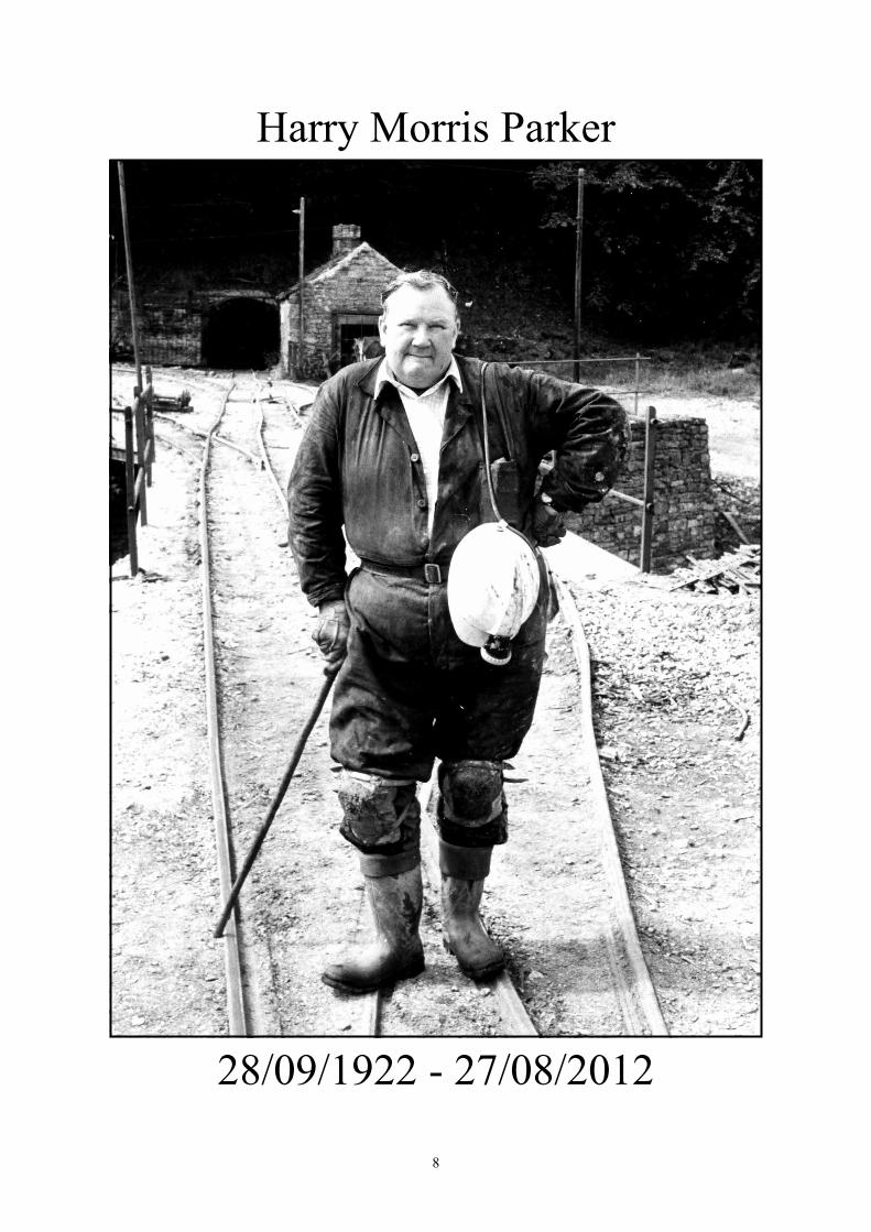
Harry Morris Parker (28/09/1922 - 27/08/2012)We are sorry to have to report the sad news that a long-standing member of the Society, Harry (HM) Parker, passed away peacefully on Monday the 27th of August. Harry’s funeral took place at Hutcliffe Wood Crematorium, followed by a service at Nether Green Methodist Church, on Thursday the 6th of September. His funeral was attended by about eighty people, with some twenty members of the Society present. For a full obituary of Harry see pages 8 & 9.
Mike and Mave Luff
The Companies Act 1985As required under Article 24 of the Articles of Association of the Company, the following Directors will retire at the AGM:
The Hon. ChairmanThe Hon. Deputy ChairmanThe Hon. EditorThe Hon. SecretaryThe Hon. RecorderTwo Ordinary Members
The Committee that was elected at the Thirty-Seventh AGM, which was held on Saturday 26th November 2011, is as follows:Chairman Mr. A. Wood *Deputy Chairman Mr. J. K. Gregory *Hon Secretary Mr. D. Weston +Hon Treasurer Mr. D. Gough (resigned 2/3/12) (Mr. A. Mutter, Acting Treasurer)Hon Recorder Mr. D. Williams +Hon Editor Dr. R. Shaw +Ordinary Members Mr. M. Long Mr. M. Luff Mr. A. Mutter Mr. A. Russell * Mr. S. Thompson Mr. D. Webb +Those whose names are marked with + are retiring as required by the Articles of Association and are eligible for re-election. Those whose names are marked * are retiring and are not eligible for re-election.
Fully paid up Members of the Society, who are aged 18 and over, are invited to nominate members of the Society (who are themselves fully paid up members and who have consented to nomination) for the vacant posts on the Committee.Nominations are required for the positions of:
Hon. ChairmanHon. Deputy ChairmanHon. RecorderHon. EditorHon. SecretaryHon. TreasurerTwo Ordinary Members
A nomination form is enclosed with this Newsletter for you to use. Any nomination will be accepted provided that it is in the format prescribed. All nominations must be received by Mr. J. D. Weston (Hon. Secretary) by 12th November 2012. Proof of postage cannot be accepted as proof of delivery.All nominations should be accompanied by a brief written resumé that will be included in the Agenda of the AGM if a ballot is required to elect Directors.To save on postage costs, nominations for the Committee may be sent with Annual Dinner bookings to Mr. K. Gregory, 3 Cobden Road, MATLOCK, Derbyshire, DE4 3JR..J.D.WestonHon Secretary
For full details of the AGM and entertainment programme, and the Miner’s Buffet, see page 15.
To All MembersNotice is hereby given that the Thirty-Eighth Annual General Meeting of the Peak District Mines Historical Society Ltd. will be held at 5.30pm on Saturday 17th November 2012 at the Peak District Mining Museum, The Pavilion, Matlock Bath, Derbyshire.The Agenda will be distributed at the start of the meeting.By OrderDavid WestonHon Secretary
Newsletter No. 144 October 2012
2
Dra
ft St
atem
ent o
f Fin
anci
al A
ctiv
ities
for
the Y
ear
Ende
d 31
st M
arch
201
2Re
stri
cted
fund
s £U
nres
tric
ted
fund
s £To
tal
2012
£To
tal
2011
£In
com
ing
reso
urce
sSu
bscr
iptio
ns-
9,68
49,
684
8,86
8A
dmis
sion
s-
31,6
7531
,675
35,3
37Sh
op sa
les
-41
,186
41,1
8644
,843
Don
atio
ns-
201
201
805
Gift
Aid
105,
113
5,12
37,
284
Din
ners
-98
998
91,
132
Bar
mot
e ev
ent
--
--
Dis
play
s and
pro
ject
s-
--
-M
agpi
e C
otta
ge F
ees
-1,
837
1,83
71,
359
Mag
pie
Cot
tage
RPA
and
rent
-4,
519
4,51
93,
054
East
Mid
land
Geo
logi
st-
--
900
Am
ortis
atio
n of
gen
erat
or fu
nd-
2626
20G
rant
s-
18,9
6418
,964
20,5
66EM
IAC
Con
fere
nce
2011
-1,
014
1,01
4-
Oth
er in
com
e-
1,35
71,
357
141
Gar
age
rent
s-
290
290
280
Sale
of l
and
at T
empl
e M
ine
-2,
000
2,00
0-
Bui
ldin
g So
ciet
y Im
tere
st4
1,52
11,
525
1,11
9To
tal i
ncom
ing
reso
urce
s14
120,
376
120,
390
125,
708
Res
ourc
es e
xpen
ded
Cha
rita
ble
expe
nditu
rePu
rcha
ses f
or R
esal
e-
18,1
7118
,171
19,9
95B
arcl
ayca
rd c
harg
es-
253
253
-M
inin
g H
isto
ry &
New
slet
ters
-7,
880
7,88
06,
979
Mer
cian
Geo
logi
st-
--
900
Mai
nten
ance
-5,
392
5,39
25,
556
Prin
t, Po
stag
e &
Sta
tione
ry-
3,05
63,
056
4,01
2A
dver
tisin
g-
1,03
51,
035
1,34
3Po
wer
, Wat
er &
Tel
ecom
ms
-5,
360
5,36
05,
043
Wag
es &
Nat
iona
l Ins
uran
ce-
37,9
6637
,966
34,7
07R
ent
-20
,587
20,5
8720
,804
Insu
ranc
e-
7,10
67,
106
6,75
6Su
bscr
iptio
ns-
8989
150
Dis
play
s and
pro
ject
s17
846
224
473
Libr
ary
-17
417
427
9A
dmin
istra
tion
301,
598
1,62
867
7D
inne
r & B
arm
ote
Even
t-
1,09
81,
098
1,21
9EM
IAC
Con
fere
nce
2011
-64
964
9-
Big
Dra
w e
vent
-1,
347
1,34
7-
Dep
reci
atio
n26
4,06
44,
090
3,29
1Lo
ss o
n di
spos
als
--
-7,
419
Mis
cella
neou
s cos
ts-
927
927
2,44
6To
tal r
esou
rces
exp
ende
d23
411
6,79
811
7,03
212
2,06
9M
ovem
ent i
n to
tal f
unds
for
the
year
-N
et in
com
e/(e
xpen
ditu
re) f
or th
e ye
ar(2
20)
3,57
83,
358
3,63
9Th
ere
wer
e no
rec
ogni
sed
gain
s or
loss
es f
or 2
012
or 2
011
othe
r th
an th
ose
incl
uded
in th
e st
atem
ent o
f fina
ncia
l act
iviti
es.
All
inco
min
g re
sour
ces a
nd re
sour
ces e
xpen
ded
deriv
e fr
om c
ontin
uing
act
iviti
es.
Bal
ance
She
et a
s at 3
1st M
arch
201
220
1220
11£
££
£Fi
xed
asse
ts
Tang
ible
ass
ets
22,8
5124
,910
Cur
rent
ass
ets
Stoc
k14
,579
15,7
36D
ebto
rs a
nd p
repa
ymen
ts3,
921
5,19
5C
ash
at b
ank
and
in h
and
198,
183
187,
968
216,
683
208,
899
Cur
rent
liab
ilitie
s
Cre
dito
rs a
nd a
ccru
als
(9,4
05)
(7,0
38)
Net
cur
rent
ass
ets
207,
728
201,
861
Tota
l ass
ets l
ess c
urre
nt li
abili
ties
230,
129
226,
771
Unr
estr
icte
d fu
nds
Peak
Dis
trict
Min
es H
isto
rical
Soc
iety
77,7
9571
,046
Peak
Dis
trict
Min
ing
Mus
eum
146,
553
149,
724
224,
348
220,
770
Res
tric
ted
fund
s
Peak
Min
e aw
ard
130
160
Gen
erat
or fu
nd78
104
Sile
nce
Min
e Fu
nd28
846
6M
agpi
e M
ine
Pow
er F
und
5,28
55,
271
230,
129
226,
771
Peak
Dis
tric
t Min
es H
isto
rica
l Soc
iety
Lim
ited
3
Meets List: Winter 2012 - 20131: Underground Meet - Pretoria Chert Mine, Bakewell.Tuesday 2nd October 2012. Leader: Paul Chandler.
2: Lake District Mines Weekend.Friday 5th to Sunday 7th October 2012. Organiser: Paul Chandler.
3: Underground Meet – Holme Bank Chert MineTuesday 9th October. Leader: Tony Wood.
Full details of these three meets were published in Newsletter No. 143, July 2012.
4: Barmote Event 2012Wednesday 17th October 2012. Event Organiser: Tony Wood.This year’s Barmote Event will be held at the Peak District Mining Museum, Matlock Bath, and will start at 11:00am prompt.New members will receive an invitation, while other members wishing to attend should contact the Museum beforehand on 01629 583834, to give them an idea of numbers for refreshments.A guided tour of the museum will be available for new members. There will be two presentations, and new members will receive a clay pipe. The event will finish at 2.00pm.
5: Underground Meet - Great Masson Cavern, Matlock BathTuesday 23rd October 2012. Leader: Tony Wood, meet 7.00pm at the Peak District Mining Museum, Matlock Bath.Another Society visit to this ever popular, extensive part natural, part mined complex. If you haven’t been before you are in for a treat. It is full of interest, with large and impressive natural caverns, very early “woodpecker” pick work, hand picked coffin levels and relatively modern mining artefacts, and is interesting from both the geological and mineralisation perspective. Well worth bringing a camera. With thanks to the Heights of Abraham for allowing access to the Masson system via the Show Cave.Reference: Lead Mining in the Peak District, edited by T D Ford and J H Rieuwerts (2000 edition).
6: Mining Heritage Walk - Ashover MinesSaturday 10th November 2012. Leader: Tony Wood, meet 10.30am at the Black Swan in Ashover.This walk will mainly take us around the sites of Overton Mine and the Gregory Mines although other sites will be pointed out along the way.Optional food and drink at the Black Swan afterwards.
7: Film Evening: An Introduction to Cave and Mine Exploration.Monday 12th November 2012. Presenter: Paul Chandler, meet 7.00 for 7.15pm at the Peak District Mining Museum, Matlock Bath. Programme: The first film shown will be “Mud & Water” (A compilation of various caves & mines in Derbyshire), followed by films on Peak Cavern and, after a refreshment break, Speedwell Cavern, both at Castleton. Finally there will be a short film entitled “Lead Mining in the Peak District”. Thanks to both David Webb and Ralph Johnson for permission to show their respective films.The film show will last about two hours.
8: Underground Meet - Peakshole Sough, Castleton.Sunday 18th November 2012. Leader: Paul Chandler.Another opportunity for Society members to visit this small, but interesting, gated lead mine. Easy/Moderate grade trip, containing water of around wellie depth in the first part of the sough. There is a series of fixed ladders or short climbs to reach the upper part of the mine, which contains some nice mineralisation and mine artifacts. Oversuit or waders are advised, with knee-pads for some optional crawly bits. Worth bringing a camera. Party size limited to eight, due to the compact nature of mine. This is a joint visit with Masson Caving Group. To book your place or get further details please contact Paul Chandler.Reference: PDMHS Bulletin Vol. 9, No.3 (1985).
9: Mining Heritage Walk - Castleton Area.Saturday 24th November 2012. Leader: Tony Wood, meet 10.30am in the main car park near Castleton Visitor Centre.A chance to see some of the mines on Castleton Moor, including the entrance to James Halls Over Engine Mine, Hazard Mine, the site of Hollandtwine Mine and the now filled in Dirtlow opencast, the course of Dirtlow Rake, How Grove Mine and Siggate Head Mine. We will also look at the cement works and Pindale Quarry.
10: Film Evening: Mining Films and Miscellaneous Snippets.Monday 26th November 2012. Presenter: Paul Chandler, meet 7.00 for 7.15pm at the Peak District Mining Museum, Matlock Bath.This film show will last about one and a half hours with a break for refreshments halfway through.The first film will feature Cornwall’s Tin Mining in a TV documentary titled “Nation on film”, plus snippets from Derbyshire. After the break a film on the Nenthead Lead Mines (With kind permission of I.A. Recordings www.iarecordings.org) will be shown, featuring visits to Smallcleugh, Rampgill & Capelcleugh Levels, plus some surface features. Finally, some more film snippets, including a “haunted mine”.

4
Please note: This film show was originally scheduled to be shown on Monday the 5th of December 2011 but had to be cancelled, due to sudden wintry weather! Belated apologies to all those who had a wasted journey!
11: Underground Meet - Rookery Black Marble Mine, AshfordTuesday 4th December 2012. Leader: Tony Wood meet 7.00pm opposite Ashford Church.Once again an opportunity to visit this popular Derbyshire mine which, if you have never visited it before, is quite extensive, easy to explore and totally different to a typical Derbyshire lead mine.An easy grade trip, dry apart from a few puddles, with mostly walking size passages. This evening visit is an ideal novice trip, but of interest to experienced mine explorers too. Access conditions limit the party size to 15 including the Leader. For further details or to book your place(s) please contact Tony Wood.
12: Mining Heritage Walk - The Alport Mining FieldThursday 27th December 2012. Leader: Tony Wood, meet 10.30am, at the George Hotel, YoulgreaveA chance to burn off the Christmas Turkey by taking a walk to visit the various mines in the Alport mining field, including the Broad Meadow shaft, where the water pressure engine that is now in the Peak District Mining Museum first worked in 1819, the site of the famous Guy Engine, the enormous Pages Shaft, Hollow Farm where Trevithick’s engineer Richard Page once lived, the sites of Crash Purse and Pienet Nest shafts and finally visiting the churchyard to look at the graves of the miners who were killed in the explosion at Mawstone Mine in 1932.Optional food and drink at the George Hotel afterwards.
13: Underground Meet - Owlet Hole, Matlock BathTuesday 15th January 2013. Leaders: Tony Wood and Martin Long, meet 7.00pm at the car park at the side of the Mining Museum.A small but interesting mine entered via a 30 ft fixed ladder, followed by a short climb down and then another fixed ladder climb of 15 ft. Helmet mounted lamp essential and wellies, boiler suit and gloves recommended. Explorers with ladder and line experience only, so definitely not a novice trip. Once at the bottom of the mine we will have a look around the former Victoria show cavern and also take a look at a fireset level. Places limited to 8 plus leaders.To book your place(s) please contact Tony Wood.
14: Mining Heritage Walk - Sheldon AreaSaturday 19th January 2013. Leader: Tony Wood, meet 10.30am at the Cock and Pullet in Sheldon Village.The walk will look at local views, and visit the Field Grove Mine. On the way back we will stop in Sheldon church yard to take a look at the graves of
the Brocklehurst family who were at one time heavily involved with Magpie Mine. If time permits a walk down to the tail of Magpie Sough may be possible.Optional food & drink afterwards at the Cock & Pullet Sheldon
15: Underground Meet - Houghton’s Pipe, Via GelliaTuesday 29th January 2013. Leader: Tony Wood, meet 7.00pm in the mill car park opposite the little white bungalow in the Via Gellia.A chance to visit this relatively short series of mine workings. This is a limited numbers trip so please book your place(s) with Tony Wood.Food and drink at the Barley Mow Bonsall afterwards.
16: Underground Meet - Mouldridge MineTuesday 12th February 2013. Leader: Tony Wood, meet at Pikehall in the lay-by near the telephone kiosk.Once again this is a limited numbers trip so please book your place(s) with Tony Wood.Food and drink afterwards at the Miners Standard in Winster.
17: Underground Meet - Good Luck MineTuesday 26th February 2013. Leaders : Good Luck Mines Preservation Group, meet at 7:00pm in the Good Luck lay-by in the Via Gellia.This is only a provisional date, yet to be confirmed, please see further details in the January 2013 newsletter.
Future Plans:Trips are already being planned for March and April 2013, as well as a possible revisit to Bage Mine.Please keep a regular check on the website for any change in circumstances on the above meet dates.The Mining Heritage Walks are a highly recommended way of getting out to meet new members and old friends. Buffets are optional and cost between £3.00 and £3.50Further details on many of the mines visited can be found in the latest edition of “Lead Mining in the Peak District” by Rieuwerts and Ford.
Contact Details:Tony Wood: Tel: 07891 276668 email: [email protected] Chandler: Tel: 01246 220773 email: [email protected]
Tony Wood
PDMHS WebsiteThe PDMHS website www.pdmhs.com is constantly being developed as a valuable source of archive material.In particular, if there are changes to scheduled meets, we do try to notify members by posting these changes on the website. If you intend to join any of the Society meets it is well worth checking for updates before travelling.

5
Life Membership Award
Wes Taylor was formally presented with his Certificate of Life Membership by PDMHS Chairman Tony Wood at the PDMHS Council meeting at Magpie Mine on Friday the 31st of August 2012.As was announced in the July Newsletter, the Directors of the Society voted to award an Honorary Membership to Wes in appreciation of his many years of invaluable service to the Society. I’m sure you will all join with the members of Council in congratulating him on this award.
Martin Long
Contributing to the NewsletterContributions to the PDMHS Newsletter will always be gratefully received. There are a number of ways you can send your masterpiece in:-1: By Email: This is perhaps in many ways the most convenient way for those equipped to use it. Preferably please send text as a Microsoft Word, or similar, file. Try to keep to a simple format, I would recommend Times New Roman in 16 point for main headings, 14 point for sub-headings and 12 point for the main body of the text. Please try to give your work a meaningful title.DO NOT embed photographs or diagrams in the text, send the images separately. Ideally send photographs as 300dpi RGB JPEG or TIFF files, drawings and diagrams may be sent in any convenient bitmap or vector format.2: By Post: If you wish to send your work by post it is best typed following the email guidelines - the text can then be scanned in directly using OCR. However, I am quite happy to accept legible hand written articles too...Good quality photographs and drawings are always welcome, or could be sent as digital images on a CD.3: By Telephone: You could even phone me and dictate an item while I crayon it on the wall to be typed later.However you choose, your contribution will be most welcome. My contact details for all three methods can be found on Page 16.
Steve Thompson
Book ReviewLead Mining in Derbyshire: History, Development and Drainage by J.H.RieuwertsVol. 1. Castleton to the River Wye (2007), Landmark, Ashbourne. 192 pp. ISBN 978-1-84306-343-8Vol. 2. Millers Dale to Alport and Dovedale (2008), Horizon Editions, Ashbourne. 142pp.ISBN 978-1-84306-344-5Vol. 3. Elton to the Via Gellia (2010), Horizon Editions, Ashbourne. 208 pp. ISBN 978-1-84306-345-2Vol. 4. The Area south of the Via Gellia (2012), Peak District Mines Historical Society Ltd. 150 pp.ISBN 978-0 904334-02-09Volumes 3 and 4 are available from the Peak District Mining Museum, Matlock, DE4 3NR at £25 per volume.
A difficulty in any mining is water flowing into the workings, and the lead miners of Derbyshire were not exempt from this problem - their many drainage levels are known as soughs. In 1987 Dr. Rieuwerts produced a privately published, limited edition, compilation bringing together some 30 years of research into widely distributed archives. His review covered the 200 soughs then known and is difficult to obtain today. A further 25 years of research in the Derbyshire Record Office, Sheffield Archives (formerly the Reference Library), in the Duke of Devonshire’s archives in Chatsworth House, the Duchy of Lancaster Archives at Chatsworth and in London, the Rutland Archives at Haddon Hall and in the National Archives (Public Record Office) at Kew and several other collections, has uncovered much more material. In particular the number of soughs has been greatly increased to well over 300; thus Dr. Rieuwerts has found it necessary to expand his 1987 book into a four volume set. A great quantity of data on the history of mining, investment and drainage is now accessible and Jim Rieuwerts has done us a service in analysing the numerous and often vague or conflicting references. Many of the historical details have been revealed by legal records of court cases which resulted from the frequent disputes between mine-owners and between sough-driving companies.Jim Rieuwerts has taken the opportunity to describe the industry as a whole, with accounts of who worked which mines and when, and how much lead ore was produced, where figures survive. Much of the history discussed relates to the 17th and 18th centuries when production was at its peak and demonstrates that the miners knew about the geological relationships of the Carboniferous Limestone, the inter-layered toadstones and the overlying shales long before geology as a science was born. Indeed their observations provided John Whitehurst with his early concept of Derbyshire stratigraphy in 1778. The miners knew that the interleaved lavas (toadstones) rarely yielded much lead ore and they could often predict they might be met. However, their knowledge had its limitations and
Wes Taylor (Left) receives his certificate of Life Membership from PDMHS Chairman Tony Wood.
Photo: Martin Long
6
these books show that they still ran into many problems, particularly when the lavas sometimes extended much further or were thicker than expected. The miners also found what appear to be volcanic vents and feeders where the toadstone could not be bottomed. Thus some soughs were abandoned or diverted when they met toadstone.The traditional categorization of the mineral deposits into rakes, scrins, pipes and flats has been followed. Rakes and scrins are more or less vertical fracture fillings whilst pipes and flats were largely controlled by “favourable” beds or, more often, by bedding planes. He has noted that the “pipes” were mineral-lined caves where roof beds could have collapsed into voids, some later filled with sediments containing detached lumps of ore, referred to by the miners as “gravel ore”. He also includes comments on the “plumbs” and “hadings” of Longstone Edge where the fissure veins are in steeply dipping limestone beds on the south side of the Longstone Edge monocline. Several important mines are discussed in detail, e.g. Magpie Mine at Sheldon, the Hillocks and Knotlow Mines near Monyash, Golconda Mine near Brassington, and Millclose Mine at Darley Dale. Many other mines are currently inaccessible, e.g. Hubbadale Mines at Flagg where it is to be hoped that mine explorers will find a way in soon. The last major lead and zinc mine at Mill Close is covered in volume 3 (not in volume 4 as implied by the map on the title page). The lead and baryte Golconda Mine is covered in volume 4.The books are illustrated with sections of the Old Series 6 inches to 1 mile Ordnance Survey maps with mining details superimposed. There are scattered references in the text to plans and diagrams in archives but few of these have been reproduced: they would have made it easier to follow the historical details and would have helped future studies.
Each volume is illustrated with photographs by Paul Deakin and others, many in colour. Volume 4 includes a survey of mining activities and trials outside the orefield at Baslow, Ashley Hay, Whitwell and Whaley Bridge. It also includes 15 pages of appendices to volumes 1 &2.
I have not seen a lot of the archives, so I cannot really criticise the detail. However, a few improvements could have been made. The mining enterprise using boat haulage in the Speedwell Mine at Castleton gets rather brief treatment in volume 1; boat haulage there has been said to be unique but in fact boats were used at several other mines and soughs. I found it difficult to work out some of the Mining Liberty boundaries: they could have been shown on a separate map or added to the existing maps. The important Stoney Middleton area is split between several maps: an extra map would have been helped, though a map of Moorwood Sough is in vol. 4. References cited in the text are not always listed, as in the Ashover chapter in vol. 4 where Stuart Band’s articles are not listed.The volumes all have comprehensive bibliographies and list of archives consulted. I did not notice many spelling or type-setting mistakes, but “Astleton” in the contents list of
volume 1 stands out. Also the BSA (British Speleological Association) documents are in the Derbyshire Record Office at Matlock, not at Lichfield as stated in the appendix to volume 1.Jim Rieuwerts is to be congratulated for bringing together so much information on what is in effect a defunct industry, but one which has left many traces of lead mining activities on both surface and underground throughout the Peak District.All these volumes should be on the shelves of anyone interested in the lead mining industry in the Peak District.
Trevor D FordEditor’s Note:The British Speleological Association documents to which Dr. Ford refers have now been transferred from the Derbyshire Record Office to the British Caving Library, Glutton Bridge, Buxton, SK17 0EN.
Steve Thompson
William Hammond, Brickmakers.Pott Hammonds was the usual name by which the firm was known in Bollington in the early days. I had long chats with Eric Hammond, the last of the Hammonds to be involved in the business of mining and brick making in Bakestonedale. It was Eric’s grandfather, William, who came from Levenshulme, South Manchester to Bakestonedale in the late 19th century. When William Hammond arrived in Bakestonedale, Gardiner was already mining and making bricks on the north side of the Bakestonedale valley, and Halls were on the south side.William Hammond married Gardiner’s daughter, and the firm Gardiner and Hammond made a range of coloured glazed bricks, white, maroon and blue, among other things. Hammond bought out Halls, and the firm William Hammond Ltd. was incorporated in 1901. The Hammond family were well liked in Bollington and the firm were known as decent employers.There were several earlier mining and brickmaking businesses in Bakestonedale and in the neighbouring Harrop valley, Kenyon & Co, George Lambert, Gardiner, and Halls, but none lasted as long as Hammonds or became so important. Eric said that the single remaining stone chimney, with the initials and date “EH 1848”, was for a steam powered crushing engine. I surmise the EH stands for Elisha Hall, a mine owner with interests around Whaley Bridge, but this is debatable. George Lambert was making bricks at the top of the dale, near Brink Farm, probably mining the Bassey seam, but they also bought coal and clay elsewhere from the mines in the Harrop Valley, and Kenyons were just over the hill in the Harrop valley.The shafts at the top of the hill above the southern side of the works in a small wood, were jigged down to the road at Pott Mill. Eric presumed this would be Hall’s mines but it seems odd that if that were so they did not have a tramroad direct to the works. So far the

7
ownership of these mines is a mystery, whatever was mined, coal or fireclay must have been carted away by road, but to where?Around the brickworks are several shafts worked in the time of Hammonds from the early 1900s. Eric said that their founder shaft was to the south-west of the works near to Moorside Lane. Other shafts were the Top Pit where the coal and clay was jigged down to the works by a steam engine, and the Rock Pit which had been lime blasted. Both these shafts were on the north side of the valley on the hill above the works. The Water Pit, where Tom Jackson was engine man, was on the north side right in the middle of the works, and the Tunnel and the Bridge Pit where Tom Thomas died, about 400yds up the valley where the track across the moor starts, now a small rough car park. The final shaft, the Moorside Mine, was next to the end of Moorside Lane. There are several other shafts and adits of which even Eric knew no history. He had capped one big shaft very near the works and the Coal Board have capped others, but neglecting some as presumably they were on none of their maps.Ventilation in the mines was never a worry, Eric believed this could be due to the multiplicity of shafts, new and old all over the site, although they did put up a brattice of tarpaulin in the Moorside shaft and a few trapdoors. He never knew of fire buckets, furnaces or blowers ever being used in the area. The pit was a naked light pit until one day Eric said there was a small “pop”, his words. The inspectors were involved and thereafter it was flameproof equipment. Only one seam, the Bassey was noted as “gassy”, this was not mined by Hammonds but had been so higher up the valley in older pits. Like all miners they were blessed with ingenuity. One day there was trouble of some sort in the Top Pit shaft, so two men were lowered down on top of the cage, but they had insufficient light to see what they were doing. The office mirror was held at the shaft top and reflected enough sunlight to finish the job.The mines were worked by pillar and stall, the pillars later being removed. In the time of the 1926 strike surface workers took coal but left the clay, which quickly swelled and blocked the passage. They mined two seams of coal and clay, one seam of clay, the Sweet Seam, was much better quality than the Stone or Ribbon Seam. At the very deepest part of the Moorside Mine, Eric said almost beneath Pott Shrigley Church, the clay became a very hard rock which only a diamond drill could cope with, but not very well. The best seam of clay was the very highest quality that can be found in this country.The Moorside Mine and the Water Pit, and probably many of the other pits both old and newer are drained by one sough which runs for about 2km south-southwest to the stream in the fields between Spuley Lane and Shrigley Road. at SJ 944 785. The line of the sough is marked on the surface by a series of beautiful shafts, each capped beehive fashion with superb ginging in the centre of a large spoil heap, but with no access track.
The Water Pit, worked by Tom Jackson about 1900, was closed sometime about 1950, but when it was opened is uncertain. It was supposed to have been sunk by a Rainow man, presumably not on his own, some time after 1870. The sough, about 2km long might, I suspect, have been constructed earlier, it was a big undertaking including the construction of six large loose pits. All the brickworks pits drained into this one sough. At the time Eric could throw no light as to where the water to work the Water Pit came from, presumably a small underground reservoir. However, some years later I received a letter from Eric, while clearing up the site for development a small, previously unknown, underground stream had been discovered which seemed to be in the right position to supply the Water Pit. He also told me a story that his father had told him. His grandfather lifted up a large stone which covered a small watercourse, and told Eric’s Dad, “if you ever find this is not running, you’re in trouble”, which must have meant that the water was now running to where it should not. It does seem that under the brickworks and Bakestonedale Moor there is much that we don’t yet know about.The most irksome task in the whole mine was the annual walking of the sough. This was necessary as any damage or blockage was sure to cause trouble, and claims might be made by aggrieved landowners. I did notice that one of the loose pits was near to the sough tail. Eric explained, about 1940 a fall very near to the tail could only be repaired by digging down to the damage, and pumping water up this shaft and into the stream, an expensive business he claimed. Water was pumped up the Moorside shaft by three pumps, then run along an underground gulley to the Water Pit and so down to the sough. A steam drawing engine was situated at the bottom of the shaft.Hammonds made every type of refractory ware, for retorts, furnaces and boilers. Some of the products were exported, even to the British rocket program at Woomera, Australia. Can you remember that? When mining ceased in Bakestonedale they purchased clay from Lancashire and Scotland. One old Bollington gentleman told me “I’d never live in Pott Shrigley, one day it’ll all disappear into the ground”, a bit extreme, but you can understand what he meant.In its prime the works were noted for untidiness, a busy place, piles of bricks all by the roadside, smoking kilns, drying sheds, the Moorside headgear, tramlines, a small tip hill and an air of real industry. In my early days in Bollington I often went by the works at night. I wondered then what these men stoking the fires of hell were really doing. In the daytime a grey smokiness over the site could be seen from our house, and sometimes at night a reddish glow. The Old Brickworks are now a pleasing small industrial estate, using some of the old buildings. Cleaner and tidier than it ever was, but nothing like so interesting!
Roger Bowling
8
Harry Morris Parker
28/09/1922 - 27/08/2012

9
Harry Morris Parker (28/09/1922 - 27/08/2012)“Harry Parker, a chubby fellow and a bit of a wag”, thus was he described by a fellow army officer before each recognised the other, after not having met for nearly thirty years.This description will be familiar to many long-serving members of the Society who may recall his many stories - and jokes - most of which were decidedly non-PC!Harry was born in Stretford, Manchester, the only child of Harry and Gladys. His father was a typewriter mechanic and salesman, who was also interested in photography. Harry developed an interest in things medical but could not afford the training and education to become a doctor. He did the next best thing and became a member of the British Red Cross Society, which he kept up until retirement.Being too young at the outbreak of war for military service he volunteered for the Air Raid Precaution Service, and joined a four-man team assigned to the first aid posts.Harry, in spite of being the youngest at 16½, was always asked to be the first to check the body!On being called up into the Lancashire Fusiliers he was determined to lead from the front, and was selected for officer training at schools including Barmouth and Barnard Castle, where his interest in mining was awakened.During parachute training he fell badly from a free jump and damaged his ankle resulting in a down-grading in fitness. This could possibly have saved his life, as the Fusiliers took part in the Arnhem raid where many were killed. To get overseas Harry volunteered for the Special Investigation Branch of the Military Police, within the office of the Provost Marshal. This took him to many places in the Far East, including Singapore.On de-mobilisation he had several short-term jobs until 1949 when he joined the Manchester City News series of weekly papers as staff photographer. In 1952 he moved to the Hull Daily Mail, an evening newspaper, again as staff photographer. The year 1959 saw his last move, to Sheffield, again as staff photographer. After short spells as Assistant Publicity Manager and Circulation Manager of the Morning Telegraph he returned to the Photographic Department as Picture Editor of Sheffield Newspapers.Many newspapers, including those in Sheffield, ran “Spot the Ball” competitions in the 1970s and early 1980s, with valuable prizes which often included holidays to what were then exotic places. Harry, with his photographic skills and medical training, was the ideal man to accompany parties of winners to New York, Florida, California, Thailand and Japan.Harry joined the Society in early 1962 and soon took up an active role, not only taking pictures of Society meets but also helping to collate the early Bulletins. This involved several volunteers walking round a large table in the Sheffield University Geology Department, each laying down a page of “duplicated” copy until all were assembled. He became a member of the Committee and also served two terms as Chairman. He was also a very effective Public Relations Officer for the Society with his many media connections, serving until the mid 1990s when ill health restricted his travelling.As a result of his overseas tours he was often invited to give illustrated talks to interested bodies. One such occasion led to a meeting with Frank Harrison of British Steel’s Ore Mining Branch, which owned fluorspar mines in the Northern Pennines. From visits to these grew the “Great Nenthead Holiday” when as many as thirty members, family and friends, staying in a variety of cottages, caravans and tents, would visit the mines and historic sites of Alston Moor, including all the working mines. On occasions the Society was asked to assist in the exploration of older parts of the working mines rather than British Steel using their own staff.Many people will be able to look at their memorabilia with pleasure, as Harry was a most generous man, and always ensured that everybody involved received copies of the numerous photos that he took.His end to travelling came, ironically, on a week’s visit to Nenthead in September 1992, when, having been asked to take “before” pictures of the old mine shops (which had just been acquired by the fledgling North Pennine Heritage Trust), he fell heavily bursting a vein in his knee. With his earlier leg injuries his mobility was severely reduced, which culminated in him entering a care home in 2010.His extensive collection of mining photographs and slides are being passed to the Society’s archive for cataloguing. Many of his pictures have appeared in the Newsletter and Bulletin, and he was particularly proud of the number that appeared in the 50th Anniversary Bulletin.
Mike and Mave Luff
10
Peak District Mines – Observations and Discoveries – Part 42Lead Hill, Derwent, Derbyshire, centred SK 197 871I have walked through this site on several occasions, noting the lead slag on the footpath. On the 18th of May 2012 I spent about three hours there and have concluded that it was a major bole smelting location. Copious amounts of small white slag are trodden into the footpath that extends from SK 197 871 to 198 871, a distance of about 20 metres. There are three separate concentrations of slag on the path. At the north-west end of the path there is a circle of stones adjacent to a large boulder (marked with a large ‘FW’ graffito). Several channels can be traced, running downhill from this site and from the others. They appear to end at small casting pits, filled with grey ash and devoid of vegetation.The boles are sited on or near the path which runs along Derwent Edge, a couple of metres below the top of the ridge which flattens out above them. They take advantage of a kink in the general north/south orientation of the edge, which for a short span turns almost to east/west. This permits the boles to face south-west to take advantage of the prevailing wind funnelling up from the junction of the Woodlands and Derwent valleys. The area above the boles, on the top of the ridge and on the plateau beyond, is covered in thick heather which prevents any clear examination of surface features, although there appears to be a small depression which could have been used as a pond.There is no known documentary evidence for the site, other than the place name Lead Hill that appears in the Ordnance Survey (1840) and is quoted by Cameron (p. 65). Bill Bevan mentions the site as a bole in his book on the Upper Derwent (p. 90), but gives no source, so I suspect it was identified through personal observation and because of the placename.The site is gradually being eroded by walkers (and cyclists) on the footpath and the possible run-off channels and casting pits are becoming overgrown. It would certainly benefit from an archaeological and geophysical survey to establish its structures and to uncover any additional features. There are very few physical remains on most Peak bole sites, other than the odd scattering of slag, so the boles on Lead Hill are of considerable historical significance.NB. The site is on Access Land, but not on a right of way. As I left the Access Land I discovered that access had been suspended for most of the second half of May and first half of June. I apologised to the grouse.
Reported: David KiernanReferences:
Bevan, B. 2004 The Upper Derwent; 10,000 Years in a Peak District Valley. Tempus.Cameron, K. 1959 The Place-Names of Derbyshire. Cambridge University Press.
Outseats Bole Hill, Outseats, Derbyshire, SK 222 840During a visit to this bole smelting site on the 8th of May 2012 the following observations were made:The finds: A small nugget of ‘white’ bole slag and a small piece of possible grey slag.Site description: The slag was found lying on a narrow track that runs just below the top of the ridge and above the wire fence that separates the hillside from New Road, west of Dennis Knoll. The site is on a very steep slope and the finds may have been pieces of debris from the very disturbed ground on the top of the ridge. The bole site was positioned at between 350-360 metres above sea level and faces directly south-west to take advantage of the wind funnelling up Hurst Clough. Much of the debris from the site may have been washed down the steep hillside into Hurst Clough, where a very high stream sediment anomaly of 1000 ppm lead was recorded at SK 211 822.Historical references: No records contemporary with the site’s use have as yet been discovered. The place name Bole Hill and the adjacent Bole Hill Wood are recorded by Cameron, but only from 1840 onwards in the Ordnance Survey. Farey (1811) refers to the site as ‘1/4 mile NW of Hurst Clough in Hathersage’.Comment: Most of the slag from the site is likely to have been extracted and transported for resmelting to the smelting mill at North Lees (SK 232 837) which was operating in the early 18th century. In fact the mill may have been built specifically for this practice which was common in this period.Access: The site is open to public access with the usual restrictions.
Reported: David KiernanReferences:
Cameron, K. 1959 The Place-Names of Derbyshire. Cambridge University Press.Farey, J. 1811 General View of the Agriculture and Minerals of Derbyshire. Volume 1.
Lead Slag Finds in North-East Derbyshire and at Burbage BrookWoodland surveys over the past few years have revealed four lead slag deposits in woods on the Coal Measures west of Chesterfield and also beside the Burbage Brook at Burbage Moor and Longshaw.Locations were recorded using a Garmin hand held GPS unit and expressed as 10 figure OS Grid references.
Gazetteer:Burbage Brook North: SK 26205 81692Lead slag eroding in a number places along a 5 metre section of footpath on the east bank of the Burbage Brook on Burbage Moor. The deposit is south of a small tributary stream flowing west into the Burbage Brook. A piece of vitrified gritstone and large pieces of slag have been found in the small stream. It may be a small bole

11
smelting site and further features may be hidden in the plantation to the east. Burbage Brook South: SK 26000 80446
Lead slag eroding from the footpath on the west side of Burbage Brook below Longshaw. A small exposure of slag along a 1.5 metre stretch of path, a series of small shallow steps back away from the path west but no other features are visible.
Cobnar Wood, Dunston: SK 35565 75520Floods caused the Barlow Brook to overflow its banks and erode a section of riverbank. It exposed a number of stones suggesting a collapsed wall. Slag and creamy litharge type deposits on gritstone (imported) was noticed. It appeared to be a lead processing site.
Fragments of charcoal and mineral coal can be seen in the river bank, this site is downstream of an early 17th century iron charcoal blast furnace so deposition from upstream is possible. The Barlow Brook at this point previously turned north, but a new course was cut in the early 20th century to isolate a bend in the old river to form a reservoir. The new cut truncated the end of this structure and possibly buried it when a weir was constructed. It is possible it is an unrecorded ore-hearth
smelting mill and that the new cut followed the line of the former mill leat, although it is nor marked on early OS maps. There is a curious quotation from Milward (1992, p. 37) ‘Later, when the Earl (of Shrewsbury) had lordship of Barlow (1589-1613) he (Arthur Mower) paid Arthur Barker, the bailiff, on the way from the lead mill at Cobnar Spring.’
Linacre Wood, Old Brampton: SK 33053 72797Fire reddened stone, lead slag and dark carbonaceous top soil was eroding from a footpath high above the Linacre Valley at 224 metres. No other features were noticeable but a spread of slag was noticed in a ploughed field to the north-east of the site. Below the site, about 8 metres north-west, a shallow dish shaped pit about 2.9 metres in diameter was noted. It did not contain any evidence of burning or carbonaceous material and it is not known whether the two features are connected. From the location of the slag it is assumed it was a bole smelting site.
Reported: Paul Smith (of Walton, Chesterfield and a different PS to our ex-chairman) and Richard Carr
Reference:Milward, R. 1992 Arthur Mower of Barlow Woodseats, County of Derby – A sixteenth Century Yeoman. Derbyshire Miscellany XIII Part 1, pp. 14-24 and Part 2, pp. 27-51.
Rifleman Mine, Lordship of Blackwell, SK 1236 7175A book in Chatsworth Archives (Chats. Bar. Coll. 164, p.558) contains the following entry:“Lordship of Blackwell May 14th 1847Then received of Samuel Mycock, Joseph Mycock, Benjamin Mycock and Thomas Hyde, one dish of Ore to free a Founder Meer of Ground for Old, on a vein ranging East and West which they call by the name of Rifleman, the said Founder is situate near the Mosely Stile in the North Fence of a field called Moor-bottom, which field is bounded on the East by Elder Lane, on the South by the Buxton Road, and on the West by Blackwell Lane, and in the occupation of Mr. Arthur H Heathcote as under tenant to William Mosely.Same time measured and staked out the said Founder.James Longsdon Deputy Barmaster ”Moor-bottom can be identified as a field of 6 acres and 6 perches on a map of 1812 (Potter 1812), in which Blackwell Lane is named as “Moor Lane”. Elder Lane has not been identified, but it is clearly an earlier name for the B6049 road to Tideswell, which splits the old Moor-bottom field almost exactly in half. The Mosely Stile was on a long-disused footpath, although its continuation south of the A6 Buxton road is still a public right of way. Interestingly there is one measurement (June 30th, 1824) of 3 loads 7 dishes at Mosely Stile, Edmund Barnes (Bag. C. 445). Was this the same mine?Shading on maps of 1825 and 1847 (Chats. Maps 3163 & 2030) appear to show the line of a vein along the northern boundary of the field, and the site of the
A piece of vitrified gritstone, and a smaller piece of slag above, at Burbage Brook North
Stones at Cobnar Wood include fire-reddened gritstones (top) and one with a creamy-coloured lead deposit (below)
12
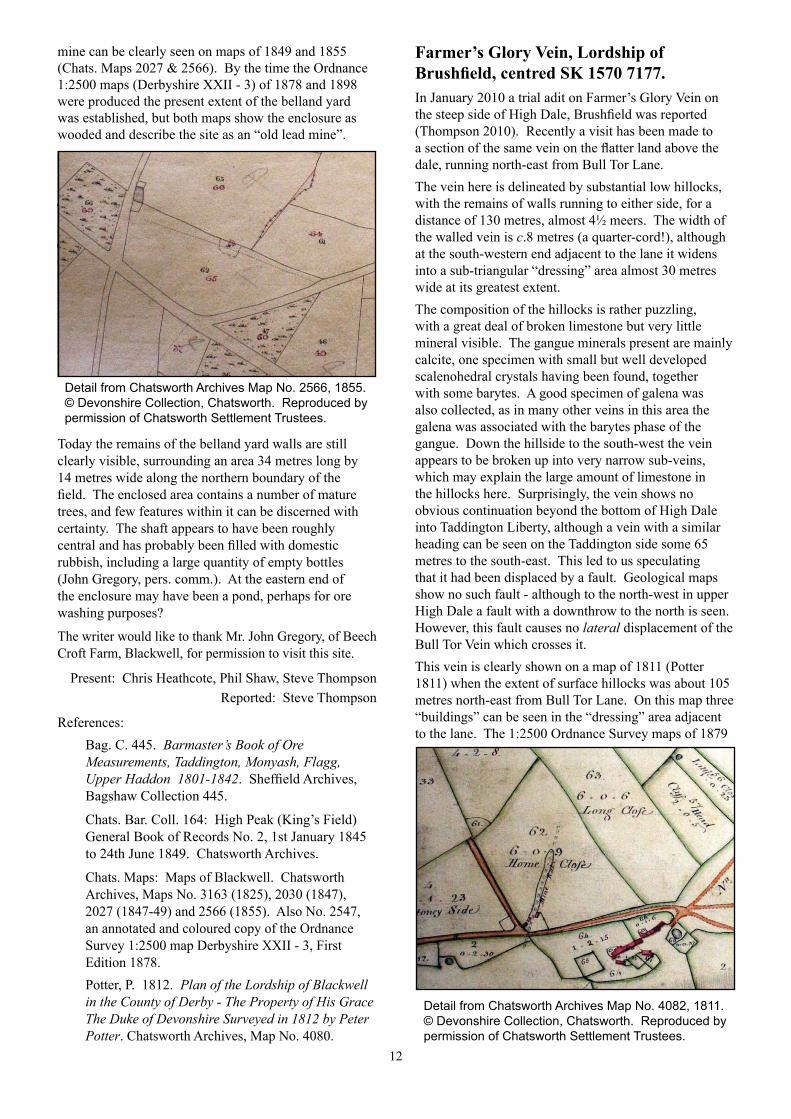
mine can be clearly seen on maps of 1849 and 1855 (Chats. Maps 2027 & 2566). By the time the Ordnance 1:2500 maps (Derbyshire XXII - 3) of 1878 and 1898 were produced the present extent of the belland yard was established, but both maps show the enclosure as wooded and describe the site as an “old lead mine”.
Today the remains of the belland yard walls are still clearly visible, surrounding an area 34 metres long by 14 metres wide along the northern boundary of the field. The enclosed area contains a number of mature trees, and few features within it can be discerned with certainty. The shaft appears to have been roughly central and has probably been filled with domestic rubbish, including a large quantity of empty bottles (John Gregory, pers. comm.). At the eastern end of the enclosure may have been a pond, perhaps for ore washing purposes?
The writer would like to thank Mr. John Gregory, of Beech Croft Farm, Blackwell, for permission to visit this site.
Present: Chris Heathcote, Phil Shaw, Steve ThompsonReported: Steve Thompson
References:Bag. C. 445. Barmaster’s Book of Ore Measurements, Taddington, Monyash, Flagg, Upper Haddon 1801-1842. Sheffield Archives, Bagshaw Collection 445.
Chats. Bar. Coll. 164: High Peak (King’s Field) General Book of Records No. 2, 1st January 1845 to 24th June 1849. Chatsworth Archives.
Chats. Maps: Maps of Blackwell. Chatsworth Archives, Maps No. 3163 (1825), 2030 (1847), 2027 (1847-49) and 2566 (1855). Also No. 2547, an annotated and coloured copy of the Ordnance Survey 1:2500 map Derbyshire XXII - 3, First Edition 1878. Potter, P. 1812. Plan of the Lordship of Blackwell in the County of Derby - The Property of His Grace The Duke of Devonshire Surveyed in 1812 by Peter Potter. Chatsworth Archives, Map No. 4080.
Farmer’s Glory Vein, Lordship of Brushfield, centred SK 1570 7177.In January 2010 a trial adit on Farmer’s Glory Vein on the steep side of High Dale, Brushfield was reported (Thompson 2010). Recently a visit has been made to a section of the same vein on the flatter land above the dale, running north-east from Bull Tor Lane.The vein here is delineated by substantial low hillocks, with the remains of walls running to either side, for a distance of 130 metres, almost 4½ meers. The width of the walled vein is c.8 metres (a quarter-cord!), although at the south-western end adjacent to the lane it widens into a sub-triangular “dressing” area almost 30 metres wide at its greatest extent.The composition of the hillocks is rather puzzling, with a great deal of broken limestone but very little mineral visible. The gangue minerals present are mainly calcite, one specimen with small but well developed scalenohedral crystals having been found, together with some barytes. A good specimen of galena was also collected, as in many other veins in this area the galena was associated with the barytes phase of the gangue. Down the hillside to the south-west the vein appears to be broken up into very narrow sub-veins, which may explain the large amount of limestone in the hillocks here. Surprisingly, the vein shows no obvious continuation beyond the bottom of High Dale into Taddington Liberty, although a vein with a similar heading can be seen on the Taddington side some 65 metres to the south-east. This led to us speculating that it had been displaced by a fault. Geological maps show no such fault - although to the north-west in upper High Dale a fault with a downthrow to the north is seen. However, this fault causes no lateral displacement of the Bull Tor Vein which crosses it.This vein is clearly shown on a map of 1811 (Potter 1811) when the extent of surface hillocks was about 105 metres north-east from Bull Tor Lane. On this map three “buildings” can be seen in the “dressing” area adjacent to the lane. The 1:2500 Ordnance Survey maps of 1879
Detail from Chatsworth Archives Map No. 2566, 1855.© Devonshire Collection, Chatsworth. Reproduced by permission of Chatsworth Settlement Trustees.
Detail from Chatsworth Archives Map No. 4082, 1811.© Devonshire Collection, Chatsworth. Reproduced by permission of Chatsworth Settlement Trustees.
13
and 1898 (Derbyshire XXIII - 1) show one shaft and one building on the vein, the extent of the workings corresponding to that of today.The first known record of Farmer’s Glory is a freeing of the 23rd of March 1808 for Original (Reginald in other documents) Dicken and Thomas Holmes (Bag. C. 443). This included one founder meer, 7 taker meers south-westwardly and 15 taker meers north-eastwardly. These meers, measured from the boundary between Taddington Liberty and Brushfield, indicate that the shaft shown on the 1879 Ordnance Survey map was probably the founder shaft. This reference also recorded that between 1808 and 1824 Farmer’s Glory produced 971 loads 7 dishes of grove ore, 8 loads 8 dishes of hillock ore and two freeing dishes. The final record known is the sale of Farmer’s Glory to Samuel Knowles for £5 in 1834 (Bag. C. 443)The writer would like to thank Mr. Fred Allen, of Top Farm, Brushfield, for permission to visit this site.
Present: Adam Russell, Steve ThompsonReported: Steve Thompson
References:Bag. C. 443. An account of all Entries made within the Lordship of Brushfield and Blackwall Likewise the Liberty of Little Longstone on the South side Wye from Jan y. 1st 1807. Sheffield Archives, Bagshaw Collection 443.Potter, P. 1811. Plan of the Lordship of Brushfield in the County of Derby - The Property of His Grace The Duke of Devonshire Surveyed in 1811 by Peter Potter. Chatsworth Archives, Map No. 4082.Thompson, S. 2010. Trial Adit, High Dale, Brushfield. In: Observations and Discoveries, Part 32, PDMHS Newsletter No. 133, January 2010.
If you have information on any of the sites noted or would like to contribute to future issues of this series of notes, please contact: Chris Heathcote, 15 Links Road, Chapel en le Frith,
High Peak, Derbys SK23 9TX (01298 814822)or John Barnatt, 21 The Front, Fairfield, Buxton,
Derbys, SK 17 7EQ (01298 77923),email: [email protected]
Lincolnshire and Nottinghamshire Air Ambulance Charity DonationThe sale of surplus publications has enabled me to make a donation of £114 to this charity.Some of the purchases were made by members attending an evening PDMHS meeting at Matlock Bath, and I would like to thank all those who contributed.For more information about the Air Ambulance see:-
http://www.ambucopter.org.uk/Geoff Warrington
Sheffield Archives and Local StudiesChanges to Opening HoursFor those of us actively researching the history of Peak District Lead Mining, one particularly important source of information is Sheffield Archives, with the Bagshawe Collection, the Oakes Deeds, Wager Holmes Collection and much, much more.From the 1st of September 2012 the opening hours at both Sheffield Archives and Sheffield Local Studies Library are changing. The revised (reduced, actually!) opening times are:Sheffield Archives
Monday and Tuesday 9.30am-5.30pmWednesday, Thursday and Friday ClosedSaturday 9.30am-5.30pm
Sheffield Local StudiesMonday and Tuesday ClosedWednesday 9.30am-8pmThursday, Friday and Saturday 9.30am-5.30pm
For more information about Sheffield Archives and the Local Studies Library visit the website:www.sheffield.gov.uk/libraries/archives-and-local-studies
Steve Thompson
New MembersPlease welcome the following people who have recently been elected as new members of the Society.
Clare Griffiths and John Wood, DARLEY DALEDawn and William Vale, MACCLESFIELDSteve Clark, DERBYRhodri Lowndes, MACCLESFIELDMichael Nicholls, MACCLESFIELD
We hope they will all get a great deal of enjoyment and interest from their membership, and play a full and rewarding part in the activities of the Society.
Laura Smith
Training Coordinator’s Notes:Rope Rescue PracticeA friend (who I shall call Caver “A”) recently invited me to Devonshire Cavern to practice some rope rescue techniques. Using a tackle bag stuffed with rocks as a casualty, we rigged and hauled in turn until happy with our efforts. As a finale we hauled each other, then de-rigged and retired to the pub. Over glasses of pop we discussed what went well, and what didn’t. Caver “A” enquired about my weight as he found the haul extremely tiring, and was disappointed to learn that I’m actually lighter than he. Confession time - while he was engrossed in hauling, I’d been slowly abseiling (which I’m surprised he didn’t notice) until I could go no further because of meeting a knot, which was holding the tackle bag, still full of rocks from our earlier efforts!
Caver “B”
14
Watergrove Mine - The (Unexpected) Luton ConnectionA paper published some 45 years ago (Kirkham, 1967) states that in 1965 two glazed earthenware jugs of Staffordshire pottery were loaned to Luton Museum. They were inscribed “Benjamin Wyatt, Foolow 1824, Success to Water Grove”. Having, rather belatedly, read this I spoke to Jim Rieuwerts, and we decided that, as I live only 30 minutes by train from Luton, I should contact Luton Museum and Art Gallery to enquire about these items. After a phone call to the museum I obtained an email address, and the following day I was in touch with Elizabeth Adey, the Curator of Local Collections at the Wardown Park Museum, part of Luton Culture.(I also suggested to Jim that perhaps we should say nothing to the rest of the Watergrove Mine project team, so that we could give them all a pleasant surprise when this Newsletter was published...)And so on Friday the 22nd of June I travelled to Luton, and to the Wardown Park Museum to meet Elizabeth Adey and to see and photograph the Watergrove Jugs.
As the photographs show, they are of very fine quality and in excellent condition, decorated with a relief moulded floral design and hand painted flowers and inscription. Benjamin Wyatt (1775-1836) was the father of William Wyatt (1803-1858), who was appointed as agent to Watergrove Mine in 1836 (Rieuwerts, 2007).
But exactly how did these two jugs come to be in Luton Museum, one might wonder?
Thomas Wyatt Bagshawe was born on the 18th of April 1901 in Dunstable. He read Geology at Gonville and Caius College at Cambridge University, but abandoned his studies to join the British Imperial Expedition to Graham Land, Antarctica between 1920 and 1922. The expedition was unfortunately cut short due to lack of funds, but Thomas Bagshawe and his colleague Maxime Charles Lester became (and remain to this day) the smallest party ever to over-winter on Antarctica! Later he wrote the first ever scientific study of the breeding behaviour of the Gentoo Penguin (Bagshawe, 1938).Luton Museum was initially established in 1927 in a room at the Carnegie Library, with Thomas Wyatt Bagshawe as Honorary Curator. After a period of vigorous campaigning led by Bagshawe and The Luton News the museum was transferred to its present home in Wardown House on the 1st of July 1931.The name Thomas Wyatt Bagshawe, of course, contains the names of two very significant families in the history of Derbyshire lead mining, the Wyatts of Foolow and the Bagshawes (or Bagshaws) of Castleton, Wormhill and many other places! Earlier this year a colleague of Elizabeth Adey had investigated his family history and had discovered the Derbyshire connection. Not long afterwards my email arrived...The two “Watergrove Jugs” were loaned to Luton Museum as a part of the Nicholas and Richard Bagshawe Collection on the 23rd of July 1962, Accession Number L/12/62. They are recorded in the museum’s accession record as “Bagshawe Personalia, Jugs (2), probably originally from a set of three”.
Steve ThompsonReferences:
Kirkham, N. 1967 Oakenedge, Streaks and Watergrove Soughs. Bulletin of the Peak District Mines Historical Society, Vol. 3, No. 4.Rieuwerts, J. H. 2007 Lead Mining in Derbyshire: History, Development & Drainage, Vol. 1 Castleton to the River Wye. Landmark.Bagshawe, T. W. 1938 Transactions of the Zoological Society of London, Vol. 24, No. 3, pp. 185–306.
Footnote:Before I left the museum to walk back to Luton station I looked round the galleries and exhibits on the ground floor. I had almost finished doing so when Elizabeth appeared again, with a sheet of paper in her hand. This was a photocopy of the original accession record for the jugs. It included these words: “See Catalogue of Sale of Mining Plant, Machinery, Materials, &c., 16.11.1853 (6704, L/3/62, Bagshawe Library No. 5079)”.I think Jim Rieuwerts did double back somersaults when I told him this! In the 1960s Jim remembers having seen a copy of this catalogue, annotated with the names of purchasers and prices paid for the various items. Its present whereabouts are unknown. There is perhaps much more exciting material yet to be found in Luton...
The two Watergrove Jugs.
Detail of the inscription on one of the jugs.All photographs by Steve Thompson, and reproduced by kind permission of Luton Culture and the Trustees of the Nicholas and Richard Bagshawe Collection.

15
The 2012 Annual General Meeting and Social EveningSaturday 17th November 2012The programme will commence at 15.00 when there will be a talk in two parts, of approximately 45 minutes each, followed by a film show. During the afternoon there will be a break for tea, coffee and biscuits.The Annual General Meeting will begin at 17.30 and last for approximately one hour. It will be followed by the Miners’ Buffet which will be served at 19.00.The buffet will cost £18.50 per head and you will be issued with a ticket for your meal when you arrive at the Museum. As was the case last year, food will be selected from the buffet menu on the day. We have a drinks licence for the sale of beer and wine at the event.To make your food reservation you can either:
Send an email to: [email protected] the Mining Museum on 01629 583834or Return the completed slip enclosed with this Newsletter to the Mining Museum at The Pavilion, South Parade, Matlock Bath, DE4 3NR
Payment in full must be received at the Museum by Saturday the 3rd of November 2012. Cheques should be made out to the Peak District Mines Historical Society.
The Afternoon Talks ProgrammeThe programme of entertainment preceding the Annual General Meeting will be as follows:Phil Wigfull: The Story of the Dakeyne Disc Engine,
which was installed at Bateman’s Shaft in Lathkilldale
David Webb: His latest film: “Good Luck Mine, a Living Legacy”
Miners’ Buffet – The MenuBaskets of Mixed Rolls from a local BakeryCarved to Order: Topside of Beef
Whole Roast Butter Basted Turkey with Stuffing, Pigs in Blankets and Cranberry Sauce
Decorated Poached Salmon FilletsHome made Cheddar Cheese and Onion PieRoast New Potatoes with Rosemary and GarlicSelection of VegetablesBowls of Mixed Chunky SaladRed Cabbage and Beetroot SaladCheese Board with Chutneys and Seasonal FruitsTerrine of Pate, Crackers and ButterSelection of traditional hearty puddings such as:
Fruit Crumble, Bread and Butter Pudding, or Strudel, served with Cream or Custard.
Robin Hall
Walking Through HistoryA film crew descended on Magpie Mine in early August to record the second in the series “Walking Through History”. The star of the programme is presenter Tony Robinson, and, of course, our own member Dr. John Barnatt. The company making the programme is a sister company to that which makes the “Time Team” series. This particular episode is on the Derwent Valley, it will start in Bakewell, then goes via Magpie Mine and several other locations right down to Derby.
The programme will be shown on Channel 4 early in 2013. The crew spent nearly three hours at the mine recording much of the site, although we look forward to seeing what will remain after editing.
Mike Luff
Dissertation ReviewAn investigation of lead contamination in soils at Smeltings Farm to assess the potential existence of a bole near Ringinglow, Sheffield.Dissertation by Stephen Marchant submitted to the Manchester Metropolitan University, March 1997.This c.90 page dissertation was submitted to Lynn Willies for possible publication in the Bulletin but never appeared. It is the result of a final year project in Environmental Science and is summarized here so that it does not “disappear”. Steve Marchant took 55 soil samples by the simple process of hammering a polythene tube into the soil on a 40 m spaced grid. The samples were analyzed by flame atomic absorption spectrometry for their lead content. Most samples had less than 500 p.p.m. as a background but one yielded 29,390 p.p.m. confirming the former presence of a lead smelting bole on disturbed ground close to the lip of the field overlooking the Limb Valley, where an adjacent copse is called Bole Hill Plantation. No archaeological dig is known to have taken place.The dissertation is being placed in the PDMHS archives for consultation by anyone interested.
Trevor D Ford
Tony Robinson (left) and John Barnatt being filmed for “Walking Through History”. Photo: Mike Luff
16
Printed by: www.folderprint.co.uk short-run folder printing
Letter to the EditorDear Editor,Re: Roger Bowling’s most interesting article “The Last Miner”, in the July 2012 Newsletter No. l43.I was also an acquaintance of the late Arthur Poulson, in fact I sold him an old Norton motorbike to tow his pit tubs out of a coal and fireclay footrill, i.e. a drift mine, that he worked. I recall his response to my concern about fumes: “If a ingin con breathe, a mon con breathe”, but he didn’t say for how long! I was working at the time as the “Mech Eng”, i.e. a collier with spanners, on a power-loading coal face at the Victoria Pit, and others in North Staffs, and was an occasional Mines Rescue dogsbody.In this capacity we were contacted, by the police I think, to search for two boys from Sutton near Macclesfield who had not returned home from a camping trip to “explore” the old mines and quarries of Wildboarclough and the Dane Valley.My first thought was to request the assistance of Arthur Poulson, who had gleaned coal from the ancient workings in this area for years. The mines known by Arthur to be “accessible” were Mousetrap, Danethorn, Danebower (three levels), Greenhills and Robins Clough. The location of some others were known, Midgeleygate, Blackclough, Chest Levels, etc., but these were not accessible, and therefore of no relevance to the search.All the accessible workings in the above areas were inspected for signs of recent entry. The main levels were photographed, paced out, compass headings noted, and the details passed on to our masters, the National Coal Board at Staffordshire House, Stoke-on-Trent. Never to see the light of day again, no doubt!All’s well that ends well: The boys finally returned home, one can only speculate on the retribution!More detail on the mines of this area can be found in the book “Valley of the Wild Stream: A History of Wildboarclough”, by Antony Borrow (Elderberry Press, September 2004).Shortly after this episode, the National Coal Board sent in the heavy gang to block up all known coal entrances. I also recall that our coal face pay was reduced to the minimum surface day rate.NB. Unauthorised entry into coal workings is illegal.
Len Kirkham
A Prestigious Award for the High Rake Project ReportYou will all have received Mining History Volume 18, Nos 1 and 2, authored by John Barnatt and his colleagues. This scholarly record is the result of ten years’ hard labour on the site, followed by countless hours spent researching and typing. Other than John Barnatt, the team which worked on the site and contributed to the publication contained no professional archaeologists: they were amateurs in the best (and truest) sense of that word.
The High Rake publication was not submitted for any award by its authors, but its wide circulation has, naturally, attracted attention in the field of Industrial Archaeology. The team members were gratified to be told recently that it had been entered for an award and had won. This award is for Fieldwork and Recording and is made by the Association for Industrial Archaeology with the aim of “promoting good archaeological recording practice” . The main award is split in two categories, one for professionals and one for amateurs, the latter awarded to the High Rake Project.
As Project Leader, John was invited to receive a cheque for £400 and a certificate at the annual conference of the Association for Industrial Archaeology in Chelmsford, Essex in early August 2012. However, because of other commitments, he was unable to attend the conference, and so it has now been arranged that he will be presented with the honour at a meeting of the association in Ironbridge early in 2013, and will give a presentation on the High Rake Project to the meeting.
The money from the award will be directed to the minor but necessary expenses of excavation and conservation in current and future digs.
You can find more about the Association for Industrial Archaeology and its annual awards by visiting:-
http://industrial-archaeology.org/
Keith Gregory
PDMHS Newsletter, January 2013The deadline for the January 2013 edition of the Newsletter is Saturday the 24th of November 2012.
Articles, photographs, letters etc. should be sent to:-Steve Thompson56 The Banks, WELLINGBOROUGH, NN9 5YXTel: 01933 675428 Email: [email protected]
Peak District Mines Historical Society Ltd.Company No 1227931 Limited by GuaranteeRegistered Charity No 504662
Registered Office: Peak District Mining Museum, Grand Pavilion, South Parade, Matlock Bath MATLOCK, DE4 3NR Tel: 01629 583834
Web Sites: Society: www.pdmhs.com Museum: www.peakmines.co.uk
The contents of this Newsletter are in the Public Domain and may be reproduced without permission provided that acknowledgment is made of the source.
Opinions expressed in this publication are those of the authors and do not necessarily reflect the opinion of the Society.