Embed Size (px)
DESCRIPTION
USGS Map of Pechanga, California
Citation preview
33 22' 30"117 07' 30"
33 30' 00"117 07' 30"
33 22' 30"117 00' 00"
33 30' 00"117 00' 00"
STATE OF CALIFORNIA - GRAY DAVIS GOVERNORTHE RESOURCES AGENCY - MARY NICHOLS, SECRETARY FOR RESOURCES
DEPARTMENT OF CONSERVATION - DARRYL YOUNG, DIRECTOR Prepared in cooperation with the U.S. Geological SurveyDIVISION OF MINES AND GEOLOGYJAMES F. DAVIS, STATE GEOLOGIST
Topographic base by U.S. Geological Survey7.5’ Pechanga QuadranglePolyconic projection, contour interval 20 feet,dotted lines 10 feet.
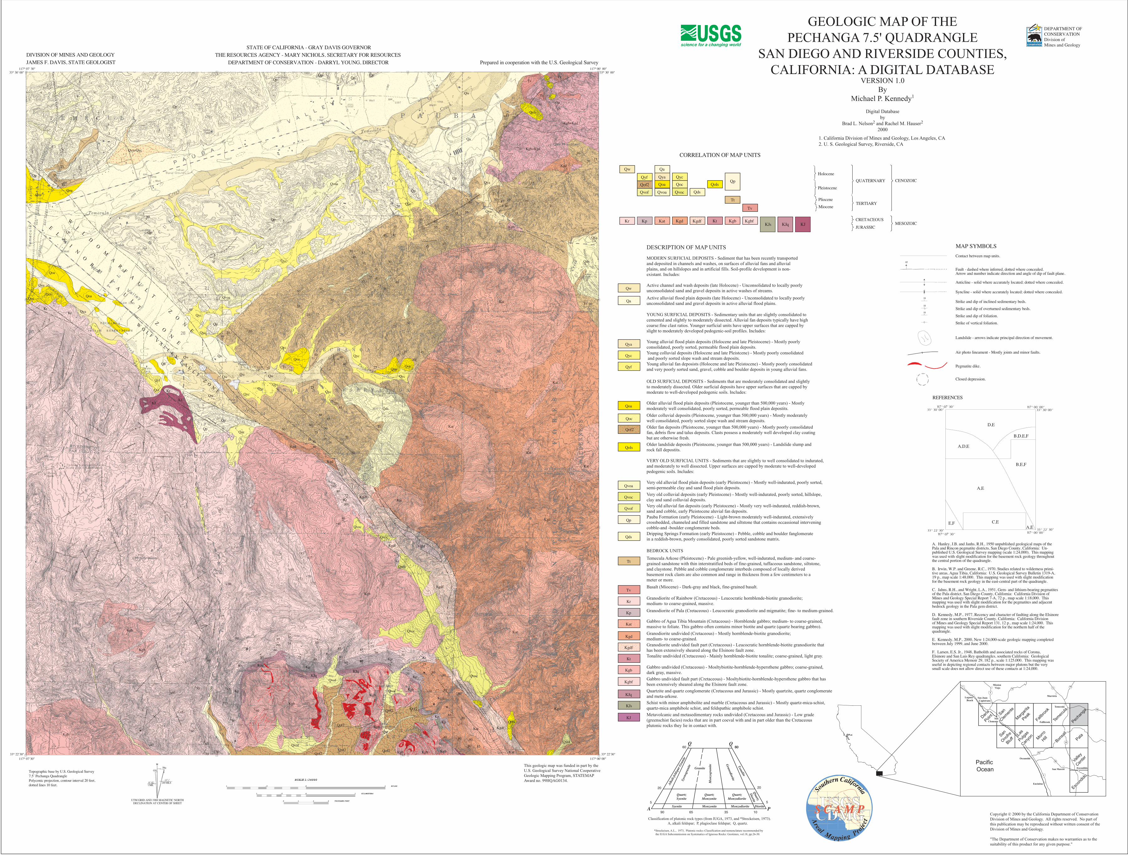
A. Hanley, J.B. and Janhs, R.H., 1950 unpublished geological maps of thePala and Rincon pegmatite districts, San Diego County, California: Un-published U.S. Geological Survey mapping (scale 1:24,000). This mappingwas used with slight modification for the basement rock geology throughoutthe central portion of the quadrangle.
B. Irwin, W.P. and Greene, R.C., 1970, Studies related to wilderness primi-tive areas, Agua Tibia, California: U.S. Geological Survey Bulletin 1319-A,19 p., map scale 1:48,000. This mapping was used with slight modificationfor the basement rock geology in the east-central part of the quadrangle.
C. Jahns, R.H., and Wright, L.A., 1951, Gem- and lithium-bearing pegmatitesof the Pala district, San Diego County, California: California Division ofMines and Geology Special Report 7-A, 72 p., map scale 1:18,000. Thismapping was used with slight modification for the pegmatites and adjacentbedrock geology in the Pala gem district.
D. Kennedy, M.P., 1977, Recency and character of faulting along the Elsinorefault zone in southern Riverside County, California: California Divisionof Mines and Geology Special Report 131, 12 p., map scale 1:24,000. Thismapping was used with slight modification for the northern half of thequadrangle.
E. Kennedy, M.P., 2000, New 1:24,000-scale geologic mapping completedbetween July 1999, and June 2000.
F. Larsen, E.S. Jr., 1948, Batholith and associated rocks of Corona,Elsinore and San Luis Rey quadrangles, southern California: GeologicalSociety of America Memoir 29, 182 p., scale 1:125,000. This mapping wasuseful in depicting regional contacts between major plutons but the verysmall scale does not allow direct use of these contacts at 1:24,000.
D,E
B,D,E,F
B,E,F
A,E
A,D,E
C,EE,FA,E
REFERENCES
Contact between map units.
Fault - dashed where inferred, dotted where concealed.Arrow and number indicate direction and angle of dip of fault plane.
Anticline - solid where accurately located; dotted where concealed.
Strike and dip of inclined sedimentary beds.
Strike and dip of overturned sedimentary beds.
Strike and dip of foliation.
Strike of vertical foliation.
Landslide - arrows indicate principal direction of movement.
Air photo lineament - Mostly joints and minor faults.
Pegmatite dike.
Closed depression.
65
18
18
18
Syncline - solid where accurately located; dotted where concealed.
MAP SYMBOLS
Qyf
Qvof
Qw
Qya
Qoa
Qvoa
Qyc
Qoc
Qvoc Qds
QolsQp
Tt
Qa
Kr Kp Kat Kgd Kgdf Kt Kgb KgbfKJqKJs
Tv
PlioceneMiocene
Pleistocene
HoloceneQUATERNARY
CRETACEOUS
JURASSIC
CENOZOIC
MESOZOIC
TERTIARY
CORRELATION OF MAP UNITS
Qw
Qa
Qya
Qyc
Qyf
Qoa
Qoc
Qof2
Qols
Qvoa
Qvoc
Qvof
Qp
Qds
Tt
Tv
Kr
Kp
Kgd
Kgdf
Kt
Kgb
Kgbf
KJ
KJq
KJs
Qof2
Kat
DESCRIPTION OF MAP UNITS
MODERN SURFICIAL DEPOSITS - Sediment that has been recently transportedand deposited in channels and washes, on surfaces of alluvial fans and alluvialplains, and on hillslopes and in artificial fills. Soil-profile development is non-existant. Includes:
Active channel and wash deposits (late Holocene) - Unconsolidated to locally poorly unconsolidated sand and gravel deposits in active washes of streams.
Active alluvial flood plain deposits (late Holocene) - Unconsolidated to locally poorlyunconsolidated sand and gravel deposits in active alluvial flood plains.
YOUNG SURFICIAL DEPOSITS - Sedimentary units that are slightly consolidated tocemented and slightly to moderately dissected. Alluvial fan deposits typically have highcoarse:fine clast ratios. Younger surficial units have upper surfaces that are capped byslight to moderately developed pedogenic-soil profiles. Includes:
Young alluvial flood plain deposits (Holocene and late Pleistocene) - Mostly poorly consolidated, poorly sorted, permeable flood plain deposits.
Young alluvial fan deposists (Holocene and late Pleistocene) - Mostly poorly consolidatedand very poorly sorted sand, gravel, cobble and boulder deposits in young alluvial fans.
Young colluvial deposits (Holocene and late Pleistcene) - Mostly poorly consolidated and poorly sorted slope wash and stream deposits.
OLD SURFICIAL DEPOSITS - Sediments that are moderately consolidated and slightly to moderately dissected. Older surficial deposits have upper surfaces that are capped bymoderate to well-developed pedogenic soils. Includes:
Older alluvial flood plain deposits (Pleistocene, younger than 500,000 years) - Mostlymoderately well consolidated, poorly sorted, permeable flood plain depostits. Older colluvial deposits (Pleistocene, younger than 500,000 years) - Mostly moderately well consolidated, poorly sorted slope wash and stream deposits.Older fan deposits (Pleistocene, younger than 500,000 years) - Mostly poorly consolidated fan, debris flow and talus deposits. Clasts possess a moderately well developed clay coatingbut are otherwise fresh.Older landslide deposits (Pleistocene, younger than 500,000 years) - Landslide slump androck fall depostits.
VERY OLD SURFICIAL UNITS - Sediments that are slightly to well consolidated to indurated, and moderately to well dissected. Upper surfaces are capped by moderate to well-developedpedogenic soils. Includes:
Very old alluvial flood plain deposits (early Pleistocene) - Mostly well-indurated, poorly sorted,semi-permeable clay and sand flood plain deposits.Very old colluvial deposits (early Pleistocene) - Mostly well-indurated, poorly sorted, hillslope,clay and sand colluvial deposits.Very old alluvial fan deposits (early Pleistocene) - Mostly very well-indurated, reddish-brown,sand and cobble, early Pleistocene aluvial fan deposits.Pauba Formation (early Pleistocene) - Light-brown moderately well-indurated, extensivelycrossbedded, channeled and filled sandstone and siltstone that contains occassional interveningcobble-and -boulder conglomerate beds.Dripping Springs Formation (early Pleistocene) - Pebble, cobble and boulder fanglomeratein a reddish-brown, poorly consolidated, poorly sorted sandstone matrix.
BEDROCK UNITS
Temecula Arkose (Pleistocene) - Pale greenish-yellow, well-indurated, medium- and coarse-grained sandstone with thin interstratified beds of fine-grained, tuffaceous sandstone, siltstone,and claystone. Pebble and cobble conglomerate interbeds composed of locally derived basement rock clasts are also common and range in thickness from a few centimeters to a meter or more.
Basalt (Miocene) - Dark-gray and black, fine-grained basalt.
Granodiorite of Rainbow (Cretaceous) - Leucocratic hornblende-biotite granodiorite;medium- to coarse-grained, massive.
Granodiorite of Pala (Cretaceous) - Leucocratic granodiorite and migmatite; fine- to medium-grained.
Gabbro of Agua Tibia Mountain (Cretaceous) - Hornblende gabbro; medium- to coarse-grained, massive to foliate. This gabbro often contains minor biotite and quartz (quartz bearing gabbro).Granodiorite undivided (Cretaceous) - Mostly hornblende-biotite granodiorite;medium- to coarse-grained.Granodiorite undivided fault part (Cretaceous) - Leucocratic hornblende-biotite granodiorite thathas been extensively sheared along the Elsinore fault zone.Tonalite undivided (Cretaceous) - Mainly hornblende-biotite tonalite; coarse-grained, light gray.
Gabbro undivided (Cretaceous) - Mosltybiotite-hornblende-hypersthene gabbro; coarse-grained, dark gray, massive.Gabbro undivided fault part (Cretaceous) - Mosltybiotite-hornblende-hypersthene gabbro that has been extensively sheared along the Elsinore fault zone.Quartzite and quartz conglomerate (Cretaceous and Jurassic) - Mostly quartzite, quartz conglomerateand meta-arkose.Schist with minor amphibolite and marble (Cretaceous and Jurassic) - Mostly quartz-mica-schist,quartz-mica amphibole schist, and feldspathic amphibole schist.Metavolcanic and metasedimentary rocks undivided (Cretaceous and Jurassic) - Low grade(greenschist facies) rocks that are in part coeval with and in part older than the Cretaceous plutonic rocks they lie in contact with.
KJ
KJs
KJs
Qa
Qw
Kr
Kr
Qoc
Qyc
Qoa
Qa
Qa
Qyc
Qw
This geologic map was funded in part by the U.S. Geological Survey National Cooperative Geologic Mapping Program, STATEMAP Award no. 99HQAG0134.
Copyright 2000 by the California Department of Conservation Division of Mines and Geology. All rights reserved. No part ofthis publication may be reproduced without written consent of theDivision of Mines and Geology.
"The Department of Conservation makes no warranties as to thesuitability of this product for any given purpose."
c
San
Onofre
Bluff
Marga
rita
Peak
Fallbr
ook
Temec
ula
Pecha
nga
PalaBon
sall
Morro
Hill
Valley
Center
San
Clemen
te
Escon
dido
Las
Pulgas
Canyo
n
Pacific Ocean
1
5
74
5
78
76
15
71 79
79
Oceanside
SanClemente
Laguna Beach
Encinitas
Mission Viejo
San Juan Capistrano
Murrieta
Temecula
Fallbrook
San Marcos Escondido
Dana
Point
GN
240 MILS13
0 021 MIL
MN
UTM GRID AND 1988 MAGNETIC NORTHDECLINATION AT CENTER OF SHEET
1/2
W I L D O M A R F A U L T
Z O N E
E L S I N O R E F A U L T
Z O N E
W O L F V A L L E Y F A U L T Z O N E
Qp
Kgb+Kgd
Tv
Qa
Qw
QpQp Qp
QpTv
Tt
Tv
Qols
Kgb+KgdQya+Qyc
Tt
Qp
Qyc
Qp
Tt
Qya
Kgd
Qp
QpQoa
Tt Qvoa
Qya
QoaTt
Qyc
Kgb
Qya
Qds
Kat TtQvoa
Qyc
Kr
Qyc
Kgd
Qyc
Qw
Qoa
QoaQoa
Kat
Tt
QycQw
Tt
Qyf QycQyc
Qyc
Qds
QycKJ
Kr
KJ
QpKatTtQp
Kat
Qoc
Kgb
Kgd
Kgd
Kat
Kgdf
Kgdf
Kr Kat
Qvoc
Kgbf
Qvoc
Kgdf
Kat
Qvoc
KrQvoc
Kgd
Kgb Qvoc
Kgb
Kr
KJqKp
Kp
Qvof
KgdKgb
KJqKJq
Kgb
Kp
Qvof Kgb
KgdfKat
Qof2Qof2
Qof2
QolsKp
Qw
Qvof
Kp
Kgb
Kgb
Qof2 Kgb
Qvof
KatKgbQof2
Kp
Qof2
Qa Qp
Qoa
Qoa
Qya
QoaQoa
Kr Qya
Kr
Qyc
Qp
QaQw
Qyf
Qa
Qw
Qw
Kgb
8580
80 8080
7570
65
70 75 8560
808070
7575
7070
75
85
85
8080
80
8585
8075
75
8585
7060
80
80
60
30
65
75
80
70
60 70
85
7270
78
8563
65
50
60
60
45
60
65
7050
40
8080
8080
72
8035
3
2
3
4
2
2
22
5
25
3
3
55
35
50
60
33
3
555
25
25
5
40
75
70 50
65
75
80
20
20 15
15
10
5
20
103040
3535
25403535
45
10
3
80
5
3
5
535
404050
30
4550
40
35
50
40
2525
3535
50
3050
20
20 25
2030
25
3025
45
30
2525
25
2540
452525
25
1025
30
25
5045
6030
3550
35
4025 35
30
75
8560
70
55
80
80
75
75
80
75
80
DEPARTMENT OFCONSERVATION Division ofMines and Geology
GEOLOGIC MAP OF THEPECHANGA 7.5' QUADRANGLE
SAN DIEGO AND RIVERSIDE COUNTIES, CALIFORNIA: A DIGITAL DATABASE
VERSION 1.0By
Michael P. Kennedy1
Digital Databaseby
Brad L. Nelson2 and Rachel M. Hauser2
2000
1. California Division of Mines and Geology, Los Angeles, CA2. U. S. Geological Survey, Riverside, CA
QuartzSyenite
QuartzMonzonite
QuartzMonzodiorite
Syenite Monzonite Monzodiorite
Granite
Alka
li-fel
dspa
r Gra
nite
Tonalite
Diorite
Syen
ogra
nite
Granodiorite
Mon
zogr
anite
Quartz
Diorite
90 65 35 10
5
20
60Q Q
A P
60
20
5
60
Classification of plutonic rock types (from IUGA, 1973, and *Streckeisen, 1973). A, alkali feldspar; P, plagioclase feldspar; Q, quartz.
*Streckeisen, A.L., 1973, Plutonic rocks--Classification and nomenclature recommended by the IUGA Subcommission on Systematics of Igneous Rocks: Geotimes, vol.18, pp.26-30.