Embed Size (px)
Citation preview

PEER REVIEW OF THE DBH SOIL SERVICES SURFICIAL SOILS ASSESSMENT BRAMPTON BRICK APPLICATION
Prepared for:
The City of Brampton
By: AgPlan Limited March 23, 2011.

AgPlan Limited 84 Callander Drive Guelph Ontario. N1E 4H8. Telephone 519-822-0750, Fax 519-822-0756 Email [email protected]
Surficial Soils Brampton Brick Norval Quarry Undertaking
1
INTRODUCTION The following describes the results of a peer review of the report prepared by Mr. David Hodgson of DBH Soil Services Inc. on behalf of Brampton Brick concerning the proposed quarry located within the City of Brampton, Regional Municipality of Peel. The DBH report has the title Surficial Soils Study West Half of Lot 12, Concession 6 WHS, City of Brampton, Regional Municipality of Peel and is dated August, 2008. AgPlan Limited was retained in October, 2010 by the City of Brampton to complete the peer review following a set of guiding questions which are summarized in this report as Appendix 1. The findings and their implications, related to Brampton's set of guiding questions, are summarized within Matrix 2-1 in Appendix 2. The analysis of positive and negative effects associated with the proposed Brampton Brick undertaking is multidisciplinary. As a result, this peer review should be read in conjunction with reports and peer reviews in other subject areas such as environment/natural heritage, hydrology, hydrogeology, planning and transportation. The information used and the opinions expressed in this peer review (including appendices) may be supplemented, reconsidered or otherwise revised by the author due to new or previously unknown information. BACKGROUND A peer review of a surficial soils study could more reasonably be structured if that surficial soils study needed to be consistent with provincial standards and guidelines for such work. Unfortunately, there are no standards or guidelines produced by the Province of Ontario and restricted to surficial soils. However, there are guidelines related to particular situations or purposes. As described by, and reproduced by DBH Soil Services; there are currently Guidelines for Detailed Soil Surveys for Agricultural Land Use Planning produced by Mr. Eric Wilson on behalf of the Ontario Ministry of Agriculture, Food and Rural Affairs (OMAFRA). There is also literature that describes surficial soil survey requirements for different circumstances/applications such as those produced by the State of Utah for alternative wastewater treatment systems (Lowe and Sorensen, 1999). As well, there are papers which generally address guidelines for surficial geology (such as Guidelines for Preparation of Surficial Geology Quadrangle MAPS for West Virginia and Adjacent States (a Working Document), J. Steven Kite Department of Geology and Geography, West Virginia University, August 2003 Revision). Therefore, this peer review has been structured around the common elements found in the surficial soils guideline literature that is available. Similar to any study of surficial soils, there is an opportunity for the use of different methods and interpretations. It is not the intent of this peer review to list and/or recommend methods and interpretations. The report by DBH not only addresses surficial soils but also uses soils data and soil interpretive classes from agriculture. Because of the DBH reference to soil capability for agriculture and the use of the Wilson (OMAFRA) document related to agricultural land use planning, in addition to the requirements of planning policy in Ontario, this peer review by AgPlan includes reference to agriculture. Similar to studies on surficial soils, Agricultural Impact Assessments (AIA) are limited by a lack of agreement on the kind of information necessary and how comprehensive the information included in the AIA is required to be. For example, current discussions with the Ontario Ministry of Agriculture Food and Rural Affairs (Turvey, 2010), indicate that the Province of Ontario has no documents which outline possible and/or probable impacts to agriculture associated with development. As a result, other sources of literature in addition to Ontario planning policy have been used to provide a framework related to the peer review of the DBH report. Two documents, both with the title Agricultural Impact Assessment Guidelines, have been produced by the Region of Halton (1985) and the Town of Caledon (draft, 2003). The Guidelines describe the process to be followed within the Region and the Town when evaluating a development proposal affecting agriculture and contain a list of information requirements (which have been interpreted and summarized in Matrix 2, Appendix 1). For Halton Region, the AIA Guidelines are a reflection of the Food Land Guidelines (1976) and for the Town of Caledon the

AgPlan Limited 84 Callander Drive Guelph Ontario. N1E 4H8. Telephone 519-822-0750, Fax 519-822-0756 Email [email protected]
Surficial Soils Brampton Brick Norval Quarry Undertaking
2
Provincial Policy Statement (1997). Some of the wording in the matrix has been reinterpreted to reflect a change based on the wording of current policy. The PPS and the Greenbelt Plan do not specifically describe possible or probable impacts to surficial soils which are a result of development. Neither do these policies specifically list the physical and chemical characteristics of soils necessary for impact assessment nor the methods appropriate for the measurement of those physical and chemical characteristics. However, the PPS does make reference to the maintenance of soil quality and ecological function whereas the Greenbelt Plan refers to rehabilitation to a state of equal or greater ecological value. Given the lack of specificity in policy, opinions which are stated within this peer review regarding soils as part of natural heritage systems, have been framed on the basis of published literature. FINDINGS Findings are summarized in two ways - descriptively in the following section and in the summary Matrix 2-1 in Appendix 2. Both the text description as well as the summary matrix should be read because not all of the peer review findings are repeated within each of these two components. Peer review comments related to policy and legislation are based on the interpretation of specific sections of policy or legislation and are summarized in Matrix 2-2 in Appendix 2. The DBH Soil Services report stated that its terms of reference were to complete a soil survey/Canada Land Inventory (CLI) classification, soil volume calculation and micro drainage assessment for an area identified as [the] West half of Lot 2, Concession 6 WHS, City of Brampton in the Regional Municipality of Peel. The terms of reference have a relatively narrow scope and are restricted to a single piece of property proposed to be developed as a quarry by Brampton Brick. There is no question that DBH Soil Services Inc. has met its terms of reference. However, much of the following discussion will indicate that the terms of reference result in information which is insufficient to meet the requirements of legislation and planning policy. The following bulleted points summarize peer review observations related to methods, information bases, data limitations/certainty, missing information, mitigation/monitoring and conclusions. Methods
The DBH Soil Services report contains a section called methodology which lists data sources and makes reference to OMAFRA guidelines for detailed soil surveys. The methodology section also indicates that slopes were measured using a hand held clinometer. Later in the report there is a list of sequential tasks followed in the production of the detailed soil survey. There is also reference to the use of a Dutch augur used as a tool to expose soils to depth, in this instance, to refusal or to a minimum depth of 100 cm. The DBH report also makes reference to the Canadian System of Soil Classification and to the Field Manual for Describing Soils in Ontario. All of the aforementioned information leads to the conclusion that standard methods were employed in the creation of the detailed soil survey. However, all of the soil attributes measured/observed in the field were not described. For example, there is no description stating that surface stoniness was broken down into classes on the basis of areal extent etc.
The methods used in the detailed soil survey did not include laboratory measurements for soil physical and chemical characteristics which could serve as a baseline against which the success of rehabilitation could later be measured. The report would benefit from information which outlines possible and probable impacts to surficial soils, measurements used as indicators of those impacts and finally, the acceptable limits within which those indicators demonstrate successful rehabilitation.
Information Bases
The subject lands description and location map provided a good reference for the proposed quarry location.
The data source listing is helpful and indicated at the beginning of the report that information from other disciplines providing impact assessment to Brampton Brick was not used in the surficial

AgPlan Limited 84 Callander Drive Guelph Ontario. N1E 4H8. Telephone 519-822-0750, Fax 519-822-0756 Email [email protected]
Surficial Soils Brampton Brick Norval Quarry Undertaking
3
soils assessment except for a single reference to the Long Environmental Concept Plan of May 2008.
Data Limitations/Certainty
Discussion on the limitations of scale associated with published soil surveys, subsequently used as a rationale for a detailed site survey, indicates one of the limitations associated with soil surveys. Other limitations with soils surveys are not described - as is most often the case within consulting surficial soil reports and AIA's. Limitations are described within the scientific literature.
The detailed soil survey follows common practice but lacks any discussion about correlation of soil characteristics and soil capability classes amongst soils given the same name. For example, Oneida and Chingacousy series have more recently been assigned different soil capability classes relative to classes assigned in older soil surveys.
The discussion about the detailed soil survey includes reference to disturbed areas but none appear to be mapped.
Missing Information
There is no cross reference to soils information collected for purposes of environmental and hydrogeological studies on behalf of Brampton Brick.
The policy review quotes from the Provincial Policy Statement (PPS, 2005), the Official Plans for the Region of Peel and the City of Brampton, the Aggregate Resources Act (1990) and the Greenbelt Plan (2005). Quotes from the PPS (2005) neglect to include sections 2.5.4.1 b) and c) which are as follows:
On these prime agricultural lands, complete agricultural rehabilitation is not required if: b. other alternatives have been considered by the applicant and found unsuitable. The consideration of other alternatives shall include resources in areas of Canada Land Inventory Class 4 to 7 soils, resources on lands identified as designated growth areas, and resources on prime agricultural lands where rehabilitation is feasible. Where no other alternatives are found, prime agricultural lands shall be protected in this order of priority: specialty crop areas, Canada Land Inventory Classes 1, 2 and 3; and c. agricultural rehabilitation in remaining areas is maximized.
DBH has failed to provide broader-scale information to put the proposed Brampton Brick site in context to other areas of similar shale resources by use of the hierarchy for agricultural lands outlined in the PPS (2005) and interpreted as shown in Figure 1 (the most important agricultural lands are at the top of the triangle and the least important lands at the bottom). The provision of broader scale information, related to impacts to agriculture outside of site-specific effects, is also required by section 2.3.5.2 of the PPS (2005) and quoted within the DBH report which states that impacts from any new or expanding non-agricultural uses on surrounding agricultural operations and lands should be mitigated to the extent feasible.
Reference has been made by DBH to the Official Plans for the Region of Peel and the City of Brampton which allow for a shale mining land use subject to a rezoning and the issuance of an Aggregate Resources Act license. Discussion follows with respect to the Aggregate Resources Act and the Greenbelt Plan. Within the DBH report, there is no discussion or interpretation of legislation and/or policy used to indicate why the wording of the PPS (2005), requiring evidence that the proposed Brampton brick quarry lands are relatively poorer agriculturally, has not been examined.
The discussion on climate would benefit from a statement on the significance, if any, of the site having 2700 - 2900 average crop heat units.
The soil survey section contains no information about soil potential for specialty crops.
AgPlan Limited 84 Callander Drive Guelph Ontario. N1E 4H8. Telephone 519-822-0750, Fax 519-822-0756 Email [email protected]
Surficial Soils Brampton Brick Norval Quarry Undertaking
4
FIGURE 1 AGRICULTURAL LAND HIERARCHY RELATED TO AGGREGATE MINING
The DBH discussion concerning artificial drainage does not have a clear statement that field observation and aerial photography either indicated, or did not indicate, the presence of tiles.
Micro drainage information described and mapped by DBH does not include a discussion on the changes to micro drainage and any possible subsequent changes to surface water quantity or quality that will result due to the quarry. Reference to those matters or to documents prepared by other consultants and which discussed drainage and subsequent changes would assist in evaluating the micro drainage information presented.
The topsoil resources section contains estimates of the volume of the “A” horizon and of the “B” horizon based on the total sample size of 16. A reference to statistics would assist in understanding whether this sample size was sufficient. The soil volume calculation also includes a number of assumptions but has no data to assist in evaluating whether these assumptions are reasonable. For example, a poorly drained soil called Jeddo has been mapped on the site and another area has been identified as ponded (no pond was included on the soil map) - what is the probability that Jeddo soils will be sufficiently dry to be stripped without soil damage and at what time of year is this probability highest (related to low moisture content)?
The topsoil and subsoil volumes are not linked to the operational site plan and to use in progressive rehabilitation.
The retainer, or terms of reference, described in the DBH Soil Services report is narrowly focused - predominantly on surficial soils whereas the DBH report section on policy and legislation indicates consideration of agriculture. Regardless, in an area designated for agricultural use, policy has a requirement for an evaluation of the effects on agriculture of any proposed new non-agricultural use. In this regard, the Applicant has failed to provide an Agricultural Impact Assessment, which includes an examination of some or all of the characteristics listed in Matrix 2, Appendix 1, as well as a site alternatives comparison.
There are several instances where links amongst the reports, completed by different disciplines providing information on behalf of Brampton Brick, are not provided. For example: o the relationship between the volumes of the "A" horizon and the "B" horizon and the volumes
of material required for berms as shown in the operational site plan; an indication of changes which will occur in those berms as a result of progressive rehabilitation;
Specialty crop areas
Soil capability class I
Soil capability class 2
Soil capability class 3
Soil rehabilitation feasible areas
Soil capability classes 4 - 7
Designated growth areas

AgPlan Limited 84 Callander Drive Guelph Ontario. N1E 4H8. Telephone 519-822-0750, Fax 519-822-0756 Email [email protected]
Surficial Soils Brampton Brick Norval Quarry Undertaking
5
o the comparison of depths to the water table and the fluctuations in depth by season and year and the significance of those depths and fluctuations relative to the recommendation for stripping soils in a dry condition;
o the DBH seed mixtures recommended for soils and the seed mixtures’ acceptability in natural, agricultural and/or urban situations;
o the significance of changes in the surface water micro drainage pattern relative to the drainage pattern during shale mining through to rehabilitation and post-rehabilitation;
o no reference has been made to possible impacts on agriculture due to noise/blasting, dust, truck traffic or changes to the water table.
The time over which the site will be stripped, mined and rehabilitated (including the time required to return groundwater levels to a pre-mining condition) has the potential to be extensive, that is, much longer than the normal planning timeframe of 20 to 30 years. Changes to natural heritage features and agriculture may be extensive during such a long time; therefore, estimates of impact to natural heritage systems and/or agriculture will require some estimation of the state of natural heritage systems and/or agricultural practice in the future.
The DBH Soil Services report has some components which are confusing. The terms of reference, are different from the broader analysis of policy found within the DBH report (as described previously within this peer review). As a second example, the policy review does suggest that rehabilitation of the lands is not required if they are to be mined below the water table. However, the DBH report includes a section on rehabilitation. Other reports provided by Brampton Brick make reference to the use of fill which would explain why rehabilitation is for a land-based system.
Mitigation/Monitoring
The general surficial soils rehabilitation plan is reasonable but is lacking in specific information. Given that the soils on the site are high in clay content, changes in soil structure resulting from soil compaction can lead to a massive soil structure that changes water movement and plant available water - subsequently affecting soil productivity. The DBH report provides insufficient detail concerning soil compaction prevention, mitigation and mitigation success.
In the surficial soils assessment, the crop types in Table 2, to be used as part of rehabilitating soils, include Reed Canary Grass which is highly invasive. The crops or vegetation species chosen for rehabilitation will need to be acceptable for agricultural uses given that the proposed site is part of the Greenbelt Protected Countryside and will also need to reflect the planned changes to urban uses within Brampton.
The successful use of vegetation and/or crop types will depend on soil physical and chemical characteristics at the time of rehabilitation. For example, certain crops will not grow on poorly drained soils and those that do grow may not prevent soil erosion by water depending on the relative amount of silt through to fine clays present in the soils on the site. Therefore, the DBH Soil Services report does not provide sufficient detail with respect to soil characteristics and the suitability of different crop types or species of vegetation relative to different soil conditions.
Conclusions
The data presented in the report are clearly and consistently presented, but are limited to surficial soils, micro drainage and soil survey. Other information sources and field analyses need to be considered for the characterization of primary and secondary impacts to surficial soils as part of natural heritage systems and/or agriculture. These other sources of information are necessary to the analysis of whether the subject quarry should be approved. In particular, the report does not comprehensively and completely address the requirements of the Provincial Policy Statement (2005) and the Greenbelt Plan as there is no discussion on:
o surficial soils concerning the ecological value and ecological function of the site soils. Additionally, there is no discussion about the relationship between soils on the site and those soils in adjacent areas,
o soil quality and how that soil quality will be measured, maintained and possibly improved, and
o the surficial soil characteristics of the site and surrounding area as being a good choice for the proposed Brampton Brick undertaking

AgPlan Limited 84 Callander Drive Guelph Ontario. N1E 4H8. Telephone 519-822-0750, Fax 519-822-0756 Email [email protected]
Surficial Soils Brampton Brick Norval Quarry Undertaking
6
Moreover, the report's conclusions are statements of fact that do not link policy requirements with the findings of the report. The report does not make conclusions regarding the consistency of the proposal with the Provincial Policy Statement (2005) or conformity with the Greenbelt Plan. For example: o Specific information concerning the probability of soil compaction or the actual time when
soils might be at their driest has not been presented within the report. o The methods to be used to stabilize the berms and the effects on soil quality of the
operational plan plantings and the subsequent retrieval and reuse of the soils in final rehabilitation of the site are not described.
o The relative success of the operational plan and of the final rehabilitation plan cannot be ascertained without additional information.
Finally, contrary to the policy requirements of the Provincial Policy Statement (2005) and the Greenbelt Plan, the recommended mitigation and monitoring measures, related to soils as part of natural heritage systems and/or agriculture, are incomplete: o Soil quality before excavation has not been compared to soil quality after rehabilitation. o The effects of mining below the water table are not described as they relate to soils as part of
agriculture and/or natural heritage systems, and the impacts have not been estimated. o Site alternatives have not been evaluated to address the PPS requirement of choice of a site
with lowest impacts (that is, extraction that minimizes social and environmental impacts). CONCLUSIONS Based on this peer review, the DBH Soil Services technical report on surficial soils (2008), as supplied by Brampton Brick, does not warrant approval based on the requirements of legislation and policy. Therefore, the acceptance of the DBH Soil Services Inc. report by the City of Brampton is not recommended. AgPlan Limited
Michael K. Hoffman REFERENCES The following references have generally not been cited but have been used as a framework for the peer review of the DBH Soil Services Inc. report. Acton, C. J. 1989. The Soils of Brant County. Report no. 55 of the Ontario Institute of Pedology.
Brampton, City of. 2010. Guideline Principles and Questions for Brampton Peer Reviewers Brampton Brick Peer Review.
Brethour, Cher, Kate Stiefelmeyer and Larry Martin. 2004. The Impact of Compliance Costs on Ontario's Competitiveness. Prepared by the George Morris Centre for the Ontario Ministry of Agriculture and Food.
Brethour, Cher, Kate Stiefelmeyer and Al Mussell. 2004. Financial Impact of the Nutrient Management Regulations (267/03) and Assessment of Affordability. Prepared by the George Morris Centre for the Ontario Ministry of Agriculture and Food.
Brown, D. M., and A. Bootsma, 1993 Crop Heat Units for Corn and Other Warm-Season Crops in Ontario, Ontario Ministry of Agriculture and Food AGDEX 111/31.
Brown, D. M. and A. Bootsma. 1991. Freeze Risk During Spring and Autumn in Ontario. Ontario Ministry of Agriculture and Food Factsheet Agdex 072.4 pp.

AgPlan Limited 84 Callander Drive Guelph Ontario. N1E 4H8. Telephone 519-822-0750, Fax 519-822-0756 Email [email protected]
Surficial Soils Brampton Brick Norval Quarry Undertaking
7
Brown, D. M., G. A. McKay, L. J. Chapman. 1968. The Climate of Southern Ontario. Climatological Studies No. 5, Meteorological Branch, Ontario Department of Transport.
Brown, D. M and R. E. Place. 1989. Rating climate in southwestern Ontario for horticultural crops. Can. J. Plant Sci. 69: 325-336.
Caledon, Town of. 2003. Agricultural Impact Assessment Guidelines. Draft.
Canada Soil Survey Committee (CSSC), Sub-committee on Soils Classification. 1978. The Canadian System of Soil Classification. Canadian Department of Agriculture Publication 1646.Supply and Services Canada, Ottawa.
Centre for Resources Development, University of Guelph. 1972. Planning for Agriculture in Southern Ontario. ARDA Report No. 7.
Chapman, L. J. and D. F. Putnam. 1973. The Physiography of Southern Ontario. 2nd Edition. University of Toronto Press.
Combe, Mary Jane, Pam Fisher, Kevin Schooley, Maribeth Fitts, Ken Slingerland. 1999. Estimated Establishment Costs and Costs of Production for Raspberries and Strawberries in Ontario. Ontario Ministry of Agriculture, Food and Rural Affairs.
Combe, Mary Jane. September 1, 2000. Establishment in the Chicken Broiler Industry. Prepared for the Ontario Ministry of Agriculture Food and Rural Affairs by Agricultural Business Consultant/Durward Jones Barkwell& Company LLP.
Ecologistics Limited and Smith, Hoffman Associates Limited. 1984. Soil Rating System for Specialty Crops. Prepared for Ontario Hydro.
Environment Canada. 1972. The Canada Land Inventory Report No. 2, Soil Capability Classification for Agriculture.
Fisher, Helen and Ken Slingerland. 2002. Site Selection for Grapes in the Niagara Peninsula.
Gillespie, J. E., R. E. Wicklund and M.H. Miller. 1971. The Soils of Halton County. Report number 43 of the Ontario Soil Survey.
Griffiths, Heather. 2006. Effects of Air Pollution on Agricultural Crops. Ontario Ministry of Agriculture, Food and Rural Affairs, Factsheet Agdex #092.
Hagerty, T. J. and M. S. Kingston 1992. The Soils of Middlesex County. Volumes 1 and 2. Report no. 56 of the Ontario Center For Soil Resource Evaluation.
Halton, Region of. 1985. Agricultural Impact Assessment Guidelines Regional Municipality of Halton.
Hoffman, D. W., 1971. The Assessment of Soil Productivity for Agriculture. ARDA Report No. 4.
Hoffman, Douglas Weir. 1973. Crop Yields of Soil Capability Classes and Their Uses in Planning for Agriculture. PhD Thesis, University of Waterloo.
Hoffman, D. W., B. C. Matthews and R. E. Wicklund. 1964. Soils Associations of Southern Ontario. Report No. 30 of the Ontario Soil Survey.
Hoffman, D. W., and H. F. Noble. 1975. Acreages of Soil Capability Classes for Agriculture in Ontario. ARDA Report Number 8.
Irwin, Ross W. 1999. Twenty Year Record of Drainage Benefit. Prepared as a factsheet for the Land Improvement Contractors of Ontario.
Kingston, M. S., and E. W. Presant. 1989. The Soils of the Regional Municipality of Niagara. Volumes 1 and 2. Report no. 60 of the Ontario Institute of Pedology.
Kroetsch, David; David Lee, Jeff Brown and Eric Wilson. 1999. Revised Soil Survey of Renfrew County. A Report of the Ontario Soil Survey.
Macintosh, E. E. and M. K. Hoffman. 1985. Rehabilitation of Sand and Gravel Pits for Fruit Production in Ontario. Prepared for the Industrial Minerals Section, Mineral Resources Branch, Ontario Ministry of Natural Resources.
McBride, Raymond A. 1983. Agronomic and Engineering Soil Interpretations From Water Retention Data. PhD Thesis. University of Guelph.

AgPlan Limited 84 Callander Drive Guelph Ontario. N1E 4H8. Telephone 519-822-0750, Fax 519-822-0756 Email [email protected]
Surficial Soils Brampton Brick Norval Quarry Undertaking
8
McCrea, P. R. 1984. An Assessment of the Effects of Road Dust on Agricultural Production Systems. Agricultural Economics Research Unit, Lincoln College, Canterbury, New Zealand. Research report no. 156.
New South Wales Department of Agriculture. Complete list of Farm Enterprise Budgets http://www.agric.nsw.gov.au/reader/2897.
Ontario Ministry of Agriculture, Food and Rural Affairs and Ontario Ministry of Environment and Energy. 2006. Minimum Distance Separation I (MDS I).
Ontario Ministry of Agriculture, Food and Rural Affairs and Ontario Ministry of Environment and Energy. 2006. MDS Implementation Guidelines.
Ontario Ministry of Agriculture, Food and Rural Affairs. 2010. Agricultural Statistics for Ontario. OMAFRA Web Site
Ontario Ministry of Municipal Affairs and Housing. 2005. Greenbelt Plan. Established under Section 3 of the Greenbelt Act, 2005.
Ontario Ministry of Natural Resources. 2010. The State of the Aggregate Resource in Ontario Study. Consolidated Report.
Presant, E. W. and C. J. Acton. 1984. The Soils of the Regional Municipality of Haldimand-Norfolk. Volumes 1 and 2. Report No. 57 of the Ontario Institute of Pedology. Land Resources Research Institute contribution No. 84-13.
Schut, L., W. 1992. The Soils of Elgin County. Volumes 1 and 2. Report no. 63 of the Ontario Center For Soil Resource Evaluation.
Schut, L., W. E. A. Wilson and P. A. Roberts. 1994. State of the Resources for the Duffin-Rouge Agricultural Preserve. Ontario Ministry of Agriculture and Food.
S. E. Yundt Limited and Stantec Consulting Ltd. 2010. Outstanding Rehabilitation and Reclamation Sites.
Statistics Canada. 1926 - 2006. Census of Agriculture data.
Steiss, Bob. 2010. Personal communication. Ontario Ministry of Agriculture, Food and Rural Affairs.
The Association of Professional Engineers, Geologists and Geophysicists of Alberta. 2006. Guideline for Professional Practice.
Turvey, John. 2010. Personal Communication. Ontario Ministry of Agriculture, Food and Rural Affairs.
Velleman, Paul F. and Leland Wilkinson. 1993. Nominal, Ordinal, Interval, and Ratio Typologies Are Misleading. Paper revised and reprinted from an article in The American Statistician (1993) 47:1, 65 - 72.
Weibe, J. and E. T. Anderson. 1976. Grape Climatic Zones in Niagara. Ontario Ministry of Agriculture and Food.
Wilson, Eric A. 2004a. Guidelines for Detailed Soil Surveys for Agricultural Land Use Planning. Ontario Ministry of Agriculture, Food and Rural Affairs.
Wilson, Eric A. 2004b. Classifying Prime and Marginal Agricultural Soils and Landscapes: Guidelines for Application of the Canada Land Inventory in Ontario. Ontario Ministry of Agriculture, Food and Rural Affairs.
Wilson, Eric A. 2010. Personal communication. Ontario Ministry of Agriculture, Food and Rural Affairs.

AgPlan Limited 84 Callander Drive Guelph Ontario. N1E 4H8. Telephone 519-822-0750, Fax 519-822-0756 Email [email protected]
Surficial Soils Brampton Brick Norval Quarry Undertaking
9
APPENDIX 1

AgPlan Limited 84 Callander Drive Guelph Ontario. N1E 4H8. Telephone 519-822-0750, Fax 519-822-0756 Email [email protected]
Surficial Soils Brampton Brick Norval Quarry Undertaking
10
MATRIX 1
REVIEW SUBCOMPONENT
GUIDING QUESTIONS
Purpose Is the purpose of the work clearly and understandably stated in the applicant’s
report/study?
Are all relevant and probable issues and impacts encompassed by the purpose?
Is the purpose worded so that it encompasses the questions that are relevant to surficial soils and/or agriculture?
Methodology Is the methodological approach to the purpose technically sound to permit an objective review of issues, data, facts, and appropriate to fulfill the purpose?
Are there technical concerns related to the methodology and assumptions that may compromise the analysis and/or the conclusions of the report/study?
Information Are relevant data and facts clearly and consistently presented in the applicant’s
report/study?
Is the information useful and is the data used critical to the conclusions?
Are the data useful and accurate, or are there concerns about their quality?
Are complete, relevant and appropriate data sets provided?
Are the relevant data and other information sufficiently detailed? Is anything
missing?
Certainty Are certainties and uncertainties of the proposal’s success openly and objectively stated in the applicant’s report/study?
Are all assumptions clearly stated? Are the assumptions reasonable?
Are the standards or thresholds commonly accepted in surficial soils and/or agriculture identified and appropriately utilized?
Issue Gaps Are there issue gaps arising from the peer review?
Were all identified issues addressed?
Are there additional issues identified through the peer review that need to be
addressed?
Are there any key issues (from the perspective of surficial soils and/or agriculture)
that have not been studied?
Mitigation/ Monitoring
Are realistic mitigation measures (or contingency plans) proposed in the applicant’s report/study? Are they presented in sufficient detail?
Do the proposed measures mitigate the impacts?
Will the proposed measures be adequate to address outstanding concerns?
Conclusion Are the conclusions of the report/study supported by and follow from the work
undertaken?
Are the conclusions relevant to the purpose/objectives of the work?
Would the peer reviewer reach the same conclusions, and if not, then what
conclusions would that reviewer reach?
Do the conclusions satisfy the applicable policies of the Official Plans and provincial plans, policies, guidelines and standards?
Adequacy Generally, does the applicant’s report/study adequately address the stated

AgPlan Limited 84 Callander Drive Guelph Ontario. N1E 4H8. Telephone 519-822-0750, Fax 519-822-0756 Email [email protected]
Surficial Soils Brampton Brick Norval Quarry Undertaking
11
REVIEW SUBCOMPONENT
GUIDING QUESTIONS
purpose?
Does the applicant’s report/study adequately address the stated purpose, from the perspective of surficial soils and/or agriculture?
Is there anything that I would have done differently?
Is the applicant’s report/study complete?
MATRIX 2
Principal information requirements
Subcomponent information
Development proposal description
Site plan, location plan, description
Site physical resource inventory
Soils and soil capability including inherent limitations to the capability classification
Site land use Past and present agricultural production, the non-agricultural uses on site, land parcel(s) shape and size, land tenure, operation and farm operator characteristics, farm capital investment
Off-site land-use Adjacent land uses (type and intensity), existing constraints imposed by external uses including Minimum Distance Separation (MDS), land parcel sizes, ownership/tenancy, off-site soil capability, off-site designations/zoning
Economic viability Viability of the lands themselves, viability when in combination with a larger farm operation, flexibility for different kinds of farm use
Impacts on agriculture Direct loss of agricultural land, affects the surrounding lands including the general area in which the site is located
Mitigation measures Methods of impact mitigation on-site and off-site Conclusions Summary and recommendations, compliance with MDS and policy Background information
Literature cited, data sources, personal communications, methodologies, Curriculum Vitae of team member(s)
AgPlan Limited 84 Callander Drive Guelph Ontario. N1E 4H8. Telephone 519-822-0750, Fax 519-822-0756 Email [email protected]
Surficial Soils Brampton Brick Norval Quarry Undertaking
12
APPENDIX 2

AgPlan Limited 84 Callander Drive Guelph Ontario. N1E 4H8. Telephone 519-822-0750, Fax 519-822-0756 Email [email protected]
Surficial Soils Brampton Brick Norval Quarry Undertaking
13
Norval Quarry Rezoning Application (Brampton Brick)
MATRIX 2-1 SURFICIAL SOILS November 23, 2010
Preliminary Review Table This table has been completed to provide a summary of the peer review work. It is not meant to be fully comprehensive, but to provide a starting point to organize thoughts and lead to final conclusions on the peer review.
Guideline Question Findings regarding the Brampton Brick Report
Implications if this concern/issue is not addressed in the technical report
Purpose
Is the purpose of the work clearly and understandably stated in the applicant’s report?
Yes. However, the purpose is limited to the characteristics of surficial soils and neglects discussion related to agriculture and the natural heritage components within the Greenbelt Plan and the PPS.
Requirements the Greenbelt/PPS are not met by this report.
Does the purpose set out the proper direction to undertake the study?
Yes, but is scoped too narrowly to surficial soils and micro drainage and therefore neglects agriculture and natural heritage.
Direction as described within the report does not relate to placing the site in a relative hierarchy of agricultural value as required by policy. Additionally it has not been demonstrated, from the perspective of soils, that there will be no negative impacts on the natural features are on their ecological functions
Methodology
Is the methodological approach technically sound? Is the review of issues, data, and facts objective and appropriate?
Methodology for soil survey is reasonable. Limitations associated with soil classification, soil survey and interpretive classifications (e.g. CLI) are not present/discussed. Discussions of limitations are not normally a part of practice but are part of the scientific literature.
Problems with soil correlation and with consistent CLI ratings for given soils (Oneida and Chingacousy mapped within the proposed site) are not mentioned and are not used to put the site in context. Interpretations of soils related to natural heritage components is lacking within the surficial soils report.
Does the peer review identify any technical concerns stemming from the methodology (and assumptions made to inform the methodology) that may compromise the analysis and/or conclusions of the report?
The methodology is focused on soil survey and neglects reference to statistical analysis, for example.
The average depth and thickness of the A and B horizons is based on a small sample size (less than 30 samples where 30 samples are stated by some authors as a necessary minimum for parametric statistics). Therefore, averages may not be correct.
Information

AgPlan Limited 84 Callander Drive Guelph Ontario. N1E 4H8. Telephone 519-822-0750, Fax 519-822-0756 Email [email protected]
Surficial Soils Brampton Brick Norval Quarry Undertaking
14
Guideline Question Findings regarding the Brampton Brick Report
Implications if this concern/issue is not addressed in the technical report
Are relevant data and facts clearly and consistently presented in the technical report?
Yes but limited to surficial soils, micro drainage and soil survey.
Links to policy are lacking.
Is information gathered from appropriate sources? Is the information useful? Accurate? Are there concerns regarding their quality or validity?
Sources are reasonable related to surficial soils. Other sources need to be considered for primary and secondary impacts to agriculture and natural heritage. There is no link between crop type/seed mixes and their utility in agricultural systems or natural heritage systems.
Some of the species recommended as part of crop types for soil stabilization in rehabilitation are highly invasive and have the potential to negatively affect the protected countryside and natural heritage areas.
Is the data used critical to the conclusions? The conclusions are statements of fact but do not link the requirements of policy with the findings of the report. Other facts presented in the literature that are associated with rehabilitation of soils have not been used in support of specific rehabilitation recommendations or plans.
The conclusions provide no insight as to whether the proposal is consistent with the PPS. Specific information concerning the probability of soil compaction or the actual time when soils might be at their driest has not been presented within the report. There is no relationship established between the amount of materials available and their use in berms which are shown as part of the operational plan. The methods to be used to stabilize the berms and the effects on soil quality of the operational plan plantings and the subsequent retrieval and reuse of the soils in final rehabilitation of the site are not described. The relative success of the operational plan and of the final rehabilitation plan cannot be ascertained without additional information.
Is the Brampton Brick report thorough/comprehensive/complete? To respond to this question, peer reviewers must consider accuracy, appropriateness and timing/seasonality of the data collection (if applicable). Where specific technical report warrants, there may be a need to consider broader connections (i.e.: water inter-relationships). Please indicate if you feel this is lacking in the Brampton Brick report and what broader connections should be considered.
The report is not comprehensive or complete given the requirements of the Greenbelt Plan and the PPS. There is no discussion about problems with correlation in the use of soil names and in the application of CLI ratings for common field crops for those specific named soils. The scientific literature related to the depth to free water within the profile and how that depth to free water changes seasonally has not been used to make
The terms of reference for this surficial soils study are too narrowly focused. However, if the report is to be judged solely on the basis of the terms of reference, there are still problems related to sample size, descriptions of limitations and reference to probable success of rehabilitation of the site.

AgPlan Limited 84 Callander Drive Guelph Ontario. N1E 4H8. Telephone 519-822-0750, Fax 519-822-0756 Email [email protected]
Surficial Soils Brampton Brick Norval Quarry Undertaking
15
Guideline Question Findings regarding the Brampton Brick Report
Implications if this concern/issue is not addressed in the technical report
recommendations related to the timing of soil removal. The sample size for the depth of A and B horizons is inadequate for the calculation of an average value (parametric statistics). Microdrainage information does not use the locations of existing swales which can be seen on aerial photographs.
How comprehensive and complete are the recommended mitigation and monitoring measures proposed by Brampton Brick? This includes assessing direct and indirect impacts; short and long term aspects.
Recommended mitigation and monitoring measures related to soils and agriculture are incomplete. Soil quality before excavation has not been compared to soil quality after rehabilitation. The effects of mining below the water table are not described as they relate to soils as components of agriculture and/or natural heritage areas. Site alternatives have not been addressed.
There are no references to existing studies or to analyses specific to the proposed site that provide information that would allow a reader of the report to put the site in context - where context examines why the site is relatively better or poorer than other potential sites and also provides context over time to demonstrate existing soil characteristics relative to post-rehabilitation soil characteristics.
The gap analysis will assess the relative importance of the data gaps and limitations to the project and identify potential options for addressing them. As such, a recommendation from a peer reviewer could be that additional survey and baseline monitoring must be undertaken as the project proceeds, provided the necessary frameworks are in place to direct this data collection and any changes that are triggered.
Data gaps include a lack of reference to the requirements of the Greenbelt Plan and the PPS, consideration of site alternatives, reference to the probability of rehabilitation success, and inadequate baseline against which to measure rehabilitation success. The report also lacks reference to studies completed by others related to water quality and quantity, dust, noise, traffic and the significance of these findings relative to surficial soils within agriculture and/or natural heritage areas.
Data gaps (e.g., no AIA, no soil dry bulk density, no field saturated hydraulic conductivity, no link to other reports and “secondary impacts”, no discussion of fill characteristics and subsequent effects) restrict the ability to characterize the number and magnitude of impacts associated with the proposed Brampton Brick undertaking.
Certainty
Are certainties and uncertainties of the proposal’s success openly and objectively stated in the applicant’s report/study?
No. The relative probability of obtaining similar soil quality post-rehabilitation is not outlined within the surficial soils report.
Are all assumptions clearly stated? Are the assumptions reasonable? Analysis of assumptions and parameters.
No. As discussed previously, assumptions associated with the classification of continua, soil classification correlation and soil

AgPlan Limited 84 Callander Drive Guelph Ontario. N1E 4H8. Telephone 519-822-0750, Fax 519-822-0756 Email [email protected]
Surficial Soils Brampton Brick Norval Quarry Undertaking
16
Guideline Question Findings regarding the Brampton Brick Report
Implications if this concern/issue is not addressed in the technical report
interpretive classification correlation are not described in the report.
Are the standards or thresholds commonly accepted in this type of technical area identified and appropriately utilized? (i.e.: transportation, soils, natural environment? Etc…)
There are few specific standards outside of those specified within policy or within the scientific literature.
There is no professional organization dictating minimum requirements or standards for the examination of surficial soils or for the production of agricultural impact assessments.
Issue Gaps
Are there issue gaps arising from the review? Yes. The requirements of the PPS are ignored -site rehabilitation to create similar levels of soil quality, choice of site with lowest impacts to agriculture. Interrelationships between disciplines have not been described to demonstrate primary and secondary impacts. For example, ability to stabilize berm slopes (necessary for visual effects and noise attenuation) of Chingacousy A horizon assuming that this material will become part of the berms shown in the operational plan.
Issues list as yet to be created; discipline specific issues are outlined at the end of this document.
Were the identified issues addressed in the technical report?
No. Discipline specific issues are outlined at the end of this document.
Are there key issues, related to the specific technical report, that have not been considered?
Yes. Discipline specific issues are outlined at the end of this document.
Mitigation/Monitoring
Are realistic mitigation measures/ rehabilitation plans proposed in the applicant’s report? Is there sufficient detail?
No. For example, baseline conditions for dry bulk density have not been described. Thus, the density of soils post-rehabilitation cannot be compared to allow for a measure of the "success" of rehabilitation.
Mitigation measures are generally descriptive, that is, they do not provide a minimum standard of what will be done, nor do they indicate soil/agricultural/natural heritage characteristics that will be monitored and at what point specific mitigation measures will be applied relative to those soil/agricultural/natural heritage characteristics.
Do the proposed measures mitigate the impacts? Is the end result desirable from a technical point of view?
No. The probability of impacts (given previous studies of lands rehabilitated to an agricultural after use) has not been used to estimate impacts. There is no
Cannot reasonably estimate impacts nor characterize their probable success.

AgPlan Limited 84 Callander Drive Guelph Ontario. N1E 4H8. Telephone 519-822-0750, Fax 519-822-0756 Email [email protected]
Surficial Soils Brampton Brick Norval Quarry Undertaking
17
Guideline Question Findings regarding the Brampton Brick Report
Implications if this concern/issue is not addressed in the technical report
reference to the literature on the success of mitigation measures applied to mitigate estimated impacts for rehabilitated lands in Ontario.
Will the proposed measures be adequate to address outstanding concerns?
No. Measures lack specificity. Cannot measure/characterize effects after the application of mitigation because a baseline has not been established.
Conclusion
Do the conclusions satisfy the applicable policies of the relevant policy documents that need to be consulted as per the specific discipline (i.e.: Official Plan, Provincial legislation, standards and guidelines, etc…). This should be informed by the policy matrix. Have implications relating to required jurisdiction and agency approvals including environmental assessments been identified?
No. The requirements of the PPS and therefore the Greenbelt Plan have not been adequately described and characterized. Report would appear to have been produced to meet ARA Category 2 standards.
The planned use is not consistent with Provincial planning policy.
Are the conclusions relevant to the purpose/objectives and supported by the work undertaken by the report authors?
Yes, given the terms of reference supplied to DBH Soil Services. No, because the terms of reference are too narrowly focused.
Policy requirements not met.
Based on the peer review, would the same conclusions be determined?
No.
Adequacy
Does the applicant’s report/study adequately address the stated purpose?
No. There is some reference to agriculture but no reference to the requirements outlined in the PPS policies 2.4.3, 2.4.4, 2.5.3 and 2.5.4. With respect to natural heritage, there is no reference to section 2.1.6 within the PPS or to section 4.2.3 (5b) in the Greenbelt Plan.
Policy requirements not met.
Is there anything that should, in your opinion, have been done differently?
Yes. As described previously. Policy requirements not met.

AgPlan Limited 84 Callander Drive Guelph Ontario. N1E 4H8. Telephone 519-822-0750, Fax 519-822-0756 Email [email protected]
Surficial Soils Brampton Brick Norval Quarry Undertaking
18
Conclusions Summary
The report includes references to operational design based on technical reports where there is no specific reference to the soil materials
described in the surficial soils study and shown as affecting the design.
There is a description of on-site soils and a map provided as support for those descriptions but there is no cross reference to soils
information collected for purposes of environmental and hydrogeological studies.
Reference is made to the soils report for Peel Region and the summary of mapped soils is correct. However, there are no discussions
about the limitations associated with the soil survey or soil surveys generally.
The report contains no analysis for other site alternatives that have been considered by the applicant and found unsuitable. The
description provided can be interpreted to mean that the suitability of alternatives is based on what might be called a business rationale.
However, the PPS (1997, 2005) makes it clear that a rationale associated with the relative quality of agricultural lands is required. The
agricultural effects of different alternatives need to be stated.
No reference has been made to possible impacts on agriculture due to noise/blasting, dust or truck traffic. The planning rationale, including
specific reference to plans and policy associated with what would appear to be an industrial use and its compatibility with agriculture has
not been discussed.
No attempt is made to characterize changes to agriculture within the time of the operation of the proposed quarry. Nor is there an estimate
of the amount and form of agriculture that may be present after rehabilitation is complete. There is no discussion of the effects on
agriculture of the quarry after use.
There is no reference to soils as part of natural heritage areas or to the role of soils in the maintenance and improvement of ecological
value.

AgPlan Limited 84 Callander Drive Guelph Ontario. N1E 4H8. Telephone 519-822-0750, Fax 519-822-0756 Email [email protected]
Surficial Soils Brampton Brick Norval Quarry Undertaking
19
MATRIX 2-2 POLICY/LEGISLATION MATRIX
Act or Policy
Legislative and/or Policy Component Considered relative to Agriculture
Discussion/Interpretation
The Greenbelt Plan
1.2.2 Goals To enhance our urban and rural areas and overall quality of life by promoting the following matters within the Protected Countryside: 1. Agricultural Protection Protection of the specialty crop area land base while allowing supportive infrastructure and value added uses necessary for sustainable agricultural uses and activities;
a. Support for the Niagara Peninsula specialty crop area as a destination and centre of agriculture focused on the agri-food sector and agri-tourism related to grape and tender fruit production;
b. Protection of prime agricultural areas by preventing further fragmentation and loss of the agricultural land base caused by lot creation and the redesignation of prime agricultural areas ;
c. Provision of the appropriate flexibility to allow for agriculture , agriculture-related and secondary uses , normal farm practices and an evolving agricultural/rural economy; and
d. Increasing certainty for the agricultural sector to foster long-term investment in, improvement to, and management of the land.
1b, c, and d have relevance. Neither the surficial soils nor the Long planning report address loss of agricultural land, the effects of the proposed quarry on the agricultural economy or the effects of the quarry and long-term investment in the agricultural sector.
3.1.1 Description The Protected Countryside contains an Agricultural System that provides a continuous and permanent land base necessary to support long-term agricultural production and economic activity. Many of the farms within this system also contain important natural heritage and hydrologic features, and the stewardship of these farms has facilitated both environmental and agricultural protection. The Agricultural System is therefore integral to the long-term sustainability of the Natural Heritage System within the Protected Countryside. It is through evolving agricultural and environmental approaches and practices that this relationship can continue and improve. The Agricultural System is made up of specialty crop areas, prime agricultural areas and rural areas. The Agricultural System includes expansive areas where prime agricultural and specialty crop lands
The links (if any) between natural heritage systems and agriculture within the protected countryside have not been addressed in the surficial soils report.

AgPlan Limited 84 Callander Drive Guelph Ontario. N1E 4H8. Telephone 519-822-0750, Fax 519-822-0756 Email [email protected]
Surficial Soils Brampton Brick Norval Quarry Undertaking
20
Act or Policy
Legislative and/or Policy Component Considered relative to Agriculture
Discussion/Interpretation
predominate and active agricultural and related activities are ongoing. The delineation of the Agricultural System was guided by a variety of factors including a land evaluation area review (LEAR) which assessed such matters as soils, climate, productivity and land fragmentation; the existing pattern of agriculturally protected lands set out in municipal official plans; and a consideration of projected future growth patterns.
4.3.2 Non-Renewable Resource Policies For lands within the Protected Countryside, the following policies shall apply:
1. Activities related to the use of non-renewable resources are permitted in the Protected Countryside, subject to all other applicable legislation, regulations and municipal official plan policies and by-laws. The availability of mineral aggregate resources for long-term use will be determined in accordance with the PPS, except as provided below.
2. Non-renewable resources are those non-agriculture based natural resources that have a finite supply, including mineral aggregate resources. Aggregates, in particular, provide significant building materials for our communities and infrastructure, and the availability of aggregates close to market is important both for economic and environmental reasons.
This section provides the information that the availability of aggregate resources will be determined following the requirements of the PPS. Those requirements have not been addressed in the Long planning report or in the surficial soils report.
4.3.2 Non-Renewable Resource Policies 4. The Ministry of Natural Resources will pursue the following under
the Aggregate Resources Act, for all mineral aggregate operations , including wayside pits and quarries, within the Protected Countryside:
a. Rehabilitated area will be maximized and disturbed area minimized on an ongoing basis during the life-cycle of an operation;
b. Progressive and final rehabilitation efforts will contribute to the goals of the Greenbelt Plan;
c. The Ministry of Natural Resources will determine the maximum allowable disturbed area of each mineral aggregate operation. Any excess disturbed area above the maximum will be required to be rehabilitated. For existing operations this shall be completed within 10 years of the date of approval of the Greenbelt Plan, and 50% completed within six years. For new operations,
The significant statement in this section is part (b) which links rehabilitation requirements back to section 1.2.2 discussed previously.

AgPlan Limited 84 Callander Drive Guelph Ontario. N1E 4H8. Telephone 519-822-0750, Fax 519-822-0756 Email [email protected]
Surficial Soils Brampton Brick Norval Quarry Undertaking
21
Act or Policy
Legislative and/or Policy Component Considered relative to Agriculture
Discussion/Interpretation
including expansions, the total disturbed area shall not exceed an established maximum allowable disturbed area; and
d. An application for a mineral aggregate operation or wayside pits and quarries may be permitted only where the applicant demonstrates that the quantity and quality of groundwater and surface water will be maintained as per Provincial Standards under the Aggregate Resources Act.
4.3.2 Non-Renewable Resource Policies 5. When operators are undertaking rehabilitation of mineral
aggregate operation sites in the Protected Countryside, the following provisions apply:
a. The aggregate industry will work with the Ministry of Natural Resources to consider the development and implementation of comprehensive rehabilitation plans in areas of high concentration of mineral aggregate operations ;
b. The disturbed area of a site will be rehabilitated to a state of equal or greater ecological value , and for the entire site, long-term ecological integrity will be maintained or restored, and to the extent possible, improved;
c. If there are key natural heritage features or key hydrologic features on the site, or if such features existed on the site at the time of application:
i. The health, diversity and size of these key natural heritage features and key hydrologic features will be maintained or restored and, to the extent possible, improved to promote a net gain of ecological health; and
ii. Any permitted extraction of mineral aggregates that occurs in a feature will be completed, and the area will be rehabilitated, as early as possible in the life of the operation.
d. Aquatic areas remaining after extraction are to be rehabilitated to aquatic enhancement, which shall be representative of the natural ecosystem in that particular setting or ecodistrict, and the combined terrestrial and
From the surficial soils perspective, part (b) is of significance. Soil characteristics are part of the ecology of the area and none of the documents reviewed described how the site soils would have an equal or greater ecological value post-rehabilitation.

AgPlan Limited 84 Callander Drive Guelph Ontario. N1E 4H8. Telephone 519-822-0750, Fax 519-822-0756 Email [email protected]
Surficial Soils Brampton Brick Norval Quarry Undertaking
22
Act or Policy
Legislative and/or Policy Component Considered relative to Agriculture
Discussion/Interpretation
aquatic rehabilitation shall meet the intent of 4.3.2.5 (c). e. Outside the Natural Heritage System, and except as
provided in 4.3.2.5 (b), (c) and (d), final rehabilitation will appropriately reflect the long-term land use of the general area, taking into account applicable policies of this Plan and, to the extent permitted under this Plan, existing municipal and provincial policies.
The Provincial Policy Statement (2005)
PPS 1.7.1 (e) Planning so that major facilities (such as airports, transportation/transit/rail infrastructure and corridors, intermodal facilities, sewage treatment facilities, waste management systems, oil and gas pipelines, industries and resource extraction activities) and sensitive land uses are appropriately designed, buffered and/or separated from each other to prevent adverse effects from odour, noise and other contaminants, and minimize risk to public health and safety. PPS 1.7.1 (g) Promoting the sustainability of the agri-food sector by protecting agricultural resources and minimizing land use conflicts;
The definition of sensitive land use in the PPS includes “residences” which may be either part of agricultural or rural area. The specifics of the possible and probable effects have not been described within the surficial soils report. The reference in part “g” to the minimizing land use conflicts has also not been addressed within the surficial soils report.
PPS 2.3.5.2 Impacts from any new or expanding non-agricultural uses on surrounding agricultural operations and lands should be mitigated to the extent feasible.
Those agricultural operations which are part of the Greenbelt and may experience positive and/or negative effects due to the operational and post-rehabilitation characteristics of the proposed aggregate pit have not been addressed within the surficial soils report.
PPS 2.5.4.1 On these prime agricultural lands, complete agricultural rehabilitation is not required if: b) other alternatives have been considered by the applicant and found unsuitable. The consideration of other alternatives shall include resources in areas of Canada Land Inventory Class 4 to 7 soils, resources on lands identified as designated growth areas, and resources on prime agricultural lands where rehabilitation is feasible. Where no other alternatives are found, prime agricultural lands shall be protected in this order of priority: specialty crop areas, Canada Land Inventory Classes 1, 2 and 3.
This section of the PPS describes a hierarchy of value of agricultural lands and the requirement for putting the soil capability characteristics of the proposed site in context with either better or poorer agricultural areas which had similar aggregate resource characteristics. There is no site alternatives analysis nor is there a discussion about the relative soil capability of the proposed site within the surficial soils or Long planning reports.
AgPlan Limited 84 Callander Drive Guelph Ontario. N1E 4H8. Telephone 519-822-0750, Fax 519-822-0756 Email [email protected]
Surficial Soils Brampton Brick Norval Quarry Undertaking
23
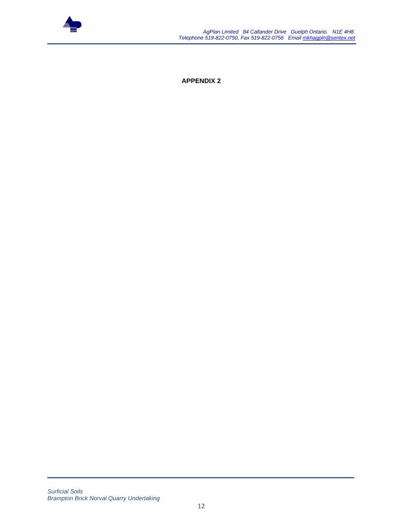
The Aggregate Resources Act
12. (1) In considering whether a licence should be issued or refused, the
Minister or the Board, as the case may be, shall have regard to,
(a) the effect of the operation of the pit or quarry on the environment;
(b) the effect of the operation of the pit or quarry on nearby communities;
(c) any comments provided by a municipality in which the site is located;
(d) the suitability of the progressive rehabilitation and final rehabilitation plans for the site;
(e) any possible effects on ground and surface water resources;
(f) any possible effects of the operation of the pit or quarry on agricultural resources;
(g) any planning and land use considerations;
(h) the main haulage routes and proposed truck traffic to and from the site;
(i) the quality and quantity of the aggregate on the site;
(j) the applicant’s history of compliance with this Act and the regulations, if a licence or permit has previously been issued to the applicant under this Act or a predecessor of this Act; and
(k) such other matters as are considered appropriate. R.S.O. 1990, c. A.8, s. 12; 1996, c. 30, s. 9 (1, 2); 2002, c. 17, Sched. F, Table.
From a surficial soils and agriculture perspective, parts (d) and (f) are of most significance. However, all parts of this section of the ARA need to be addressed within the surficial soils report.
Aggregate Resources Act Standards Category 2
1.2 Operations
1.2.2 details of how the stripping and stockpiling of the topsoil and overburden will be dealt with;
1.2.19 details on how berms will be vegetated and maintained;
Specific information about the berms shown in the operational design and the storage location of topsoil (A horizon), B horizon and C horizon (parent materials) is not clear within the surficial soils report. There are no discussions about the kinds of equipment that will be used and their projected effects on soils (particularly

AgPlan Limited 84 Callander Drive Guelph Ontario. N1E 4H8. Telephone 519-822-0750, Fax 519-822-0756 Email [email protected]
Surficial Soils Brampton Brick Norval Quarry Undertaking
24
1.2.20 the general types of equipment that will normally be used on site;
1.2.28 any recommendations and/or monitoring program(s) identified in the technical reports.
soil compaction and/or soil mixing).
1.3 Progressive Rehabilitation
1.3.2 details on how the overburden and topsoil will be used to facilitate progressive rehabilitation;
1.3.3 the location, design and type of vegetation (e.g. grasses, legumes, shrubs and trees, etc.) that will be established on the site during progressive rehabilitation;
1.3.4 how the slopes will be established on the excavation faces and the quarry floor;
1.3.5 details on how progressive rehabilitation will be conducted in relation to the operational sequences; and
1.3.6 if proposed, details on the importation of topsoil or inert material to facilitate rehabilitation of the site.
Again, the specifics for all parts of progressive rehabilitation are not clear. The Long planning report makes reference to the use of inert fill. Information on the texture, density and structure of the fill and the effect of those characteristics on field saturated hydraulic conductivity, for example, are not discussed.
1.4 Final Rehabilitation
1.4.1 if proposed, details on the importation of topsoil or inert material to facilitate rehabilitation of the site;
1.4.2 how the final slopes will be established on all excavation faces and the quarry floor;
1.4.3 the location, design and type of vegetation (e.g. grasses, legumes, shrubs, and trees, etc.) that will be established on the site during final rehabilitation;
1.4.4 any building(s) or structure(s) to remain on the site;
1.4.5 anticipated elevation of the groundwater table;
1.4.6 any internal haul roads that will remain on the site;
As stated previously, details are lacking with respect to importation of soil materials. The desirability of the proposed grasses and legumes has not been described within the surficial soils report. Additionally, there is no discussion about depth to free water within surficial soils as opposed to ground water table elevation - existing conditions, operational conditions and post-rehabilitation conditions.

AgPlan Limited 84 Callander Drive Guelph Ontario. N1E 4H8. Telephone 519-822-0750, Fax 519-822-0756 Email [email protected]
Surficial Soils Brampton Brick Norval Quarry Undertaking
25
1.4.7 final surface water drainage and drainage facilities on the site;
1.4.8 the final elevations of the rehabilitated areas of the site illustrated by a one or two meter contour interval, expressed as metres above mean sea level, and;
1.4.9 location of cross-section(s).
1.5 Cross-Sections
1.5.1 one or more cross-sections of existing conditions, rehabilitation and the anticipated final elevation of the groundwater table, within the licensed boundary;
1.5.2 the final slope gradients that will be established
1.5.3 the cross-section of a typical berm design that will be constructed on the site
2.1 Summary Statement
A summary statement accompanying an application for a licence must be signed by the author and provide information on the following:
2.1.1 any planning and land use considerations;
2.1.2 the agricultural classification of the proposed site, using the Canada Land Inventory classes. For the land being returned to agriculture, the proposed rehabilitation techniques must be identified.
The summary statement requirements specify the need for an analysis of planning policy - the detail of which is lacking in the surficial soils report.
The report does described Canada Land Inventory soil capability class values but does not address the fact that the soils found on the site have different soil capability values in different Regions and/or Counties.
3.0 Prescribed Conditions that Apply to Category 2 Licences
The licence is subject to the following conditions:
3.1 Dust will be mitigated on site.
3.2 Water or another provincially approved dust suppressant will be applied to internal haul roads and processing areas as often as required to mitigate dust.
3.3 Processing equipment will be equipped with dust suppressing or collection devices, where the equipment creates dust and is being
There are no discussions about the effects of dust on agricultural crops with particular emphasis on crop yields and crop quality. There are no discussions about a dust monitoring program related to agricultural crops.

AgPlan Limited 84 Callander Drive Guelph Ontario. N1E 4H8. Telephone 519-822-0750, Fax 519-822-0756 Email [email protected]
Surficial Soils Brampton Brick Norval Quarry Undertaking
26
operated within 300 metres of a sensitive receptor.
3.4 Any recommendations and/or recommended monitoring program identified in the technical reports will be described on the site plan and all records will be retained by the licensee and made available upon request by the Ministry of Natural Resources for audit purposes.
5 .0 Operational Standards that Apply to Licences
5.4 topsoil must be stripped sequentially prior to aggregate extraction;
5.6 all topsoil or overburden that is stripped during the operation of the site will be stored separately with vegetated stable slopes;
5.16 removal of topsoil from the site shall not occur;
5.17 all topsoil or overburden stripped in the operation of the site is used in the rehabilitation of the site;
5.18 adequate vegetation is established and maintained to control erosion of any topsoil or overburden replaced on the site for rehabilitation purposes;
5.21 rehabilitation of the site shall ensure that: 5.21.1 adequate drainage and vegetation of the site is provided; and 5.21.2 any compaction of the site is alleviated;
Most of these components have been addressed generally within the surficial soils report. However, the ability of the grass and legumes recommended to control erosion relative to different slope gradients has not been described. Steep slopes may fail irrespective of vegetative cover.
The clay soils found on the site have the potential, under wet or moist conditions, to lose their structure (where structure refers to the aggregation of soil particles into distinct forms such as blocky or granular). If structure is lost then the soil is described as massive and soil water relationships are change significantly. The soil water change subsequently affects the health and cover of vegetation.
Issues
No AIA (Agricultural Impact Assessment).
No site alternatives comparison following the relative agricultural land value hierarchy requirements of the PPS.
No baseline soils chemical and physical characteristics.
No reference the literature indicating the probability of the maintenance of soil ecological value and ecological function.
Few links amongst information provided by different disciplines. For example, dust effects on agricultural crops.
Lack of detail - for example, vehicle load relative to soil bearing capacity, use of geotextiles to improve soil bearing capacity, specific
vehicle traffic patterns for the removal of topsoil and subsoil and the placement of the soils in berms, no reference to the literature to help
ascertain the probable level of soil compaction and the relative success in alleviating compaction, no current versus post-rehabilitation soil
capability discussion.