Embed Size (px)
Citation preview

PENN VIRGINIA LAND COMPANY – AREA A
HENDERSON COUNTY
ENERGY PROJECT SITE SUITABILITY
2009
Department of Energy Development and Independence
Energy and Environment Cabinet Commonwealth of Kentucky

FOREWORD
Penn Virginia Land Company submitted this site for evaluation for potential
development as an alternative energy facility. The site was evaluated against
preliminary criteria which identifies characteristics beneficial for development of a wind,
solar, biomass, nuclear, or coal-to liquid (CTL)/coal-to-gas (CTG) facility. This site
benefits from a location in the Western Kentucky Coal Fields, access to substantial
water resources and flexible transportation options.
Cover photo (2008) - Proposed development site

The Penn Virginia Land Company has offered the Area A property to be evaluated as a
potential energy facility. The development of an energy facility, whether for CTL/CTG,
wind, nuclear, solar or biomass, must consider basic common factors which include
assets like access to transportation, general topography, proximity to public access
areas, and available utilities.
GENERAL SITE CONSIDERATIONS
Ownership
The surface and coal under the property are owned by Penn Virginia. Oil wells located
on the site are managed by Continental Resources.
Aerial photograph of development area
Penn Virginia -Area A – Henderson County Page 1

Size
Penn Virginia offers approximately 1,000 acres of previously mined land in Henderson
County on the Green River, immediately south of the Audubon Parkway (USGS
Spottsville, Reed, Curdsville and Delaware topographic quadrangles). The site is
adjacent to additional property to the northeast available for development, equaling over
2,600 acres. Property to the southwest is currently under development as a coal
gasification facility.
Topography
The proposed site was previously surface mined. The limited residential land use in the
area is not adjacent to the site, and it is not anticipated that other land uses nearby will
pose issues with development of an energy facility as a result of the previous land use.
Significant portions of the property have been surface mined and may have up to 100
feet of mine spoil placed above the residual material. This may present a challenge in
siting those aspects of an alternative energy facility that require substantial foundations.
Floodplain and Wetlands
Some areas of the site located along the Green River and along the west side of the
property were noted to lie within the 100-year floodplain, but the vast majority of the
proposed site is not impacted by floodplains. A small area of wetlands is identified,
associated with the mouth of the stream located on the western edge of the property.
The size and location of the identified wetland should not impede the development of
the site.
Site Hazards
Environmental databases were reviewed to determine if there is regulatory evidence
that the site or a nearby property has been impacted by environmental issues.
According to a 2008 FirstSearch Environmental Database Report, the Penn Virginia
Area A site was not identified on any environmental databases searched nor were any
other facilities identified with the radius search.
Penn Virginia -Area A – Henderson County Page 2

Oil and Gas Wells
There are producing oil wells located on the site which are managed by Continental
Resources. These wells are located primarily along ridges above the main
development area and are not expected to pose significant issue for the proposed
development.
Producing oil well
Sensitive Areas
The proximity of non-attainment areas and Class I Visibility Areas to the site was
examined for potential impacts to air quality or limitations on a required air permit for a
CTL/CTG or biomass facility. The nearest air quality non-attainment area is located at
least 20 miles distant in Evansville, Indiana. Careful planning may be required,
however, to assure that development or operation does not adversely impact Mammoth
Cave National Park, a Class I Visibility Area located approximately 75 miles southeast
of the proposed site.
Penn Virginia -Area A – Henderson County Page 3

Stream located on proposed site
State water data was searched to determine if designated impaired streams in the area
might affect discharge requirements for an energy facility. The site is not located near
impaired bodies of water which could complicate planning or development by limiting
flexibility with regard to discharge requirements. The proposed site is located along the
Green River (part of Green and Tradewater River Basin). There are no public water
intakes within 25 miles downstream of the site. Use designations for the Green River in
accordance with 401 KAR 10:026 include warm water aquatic habitat, primary contact
recreation, secondary contact recreation, and drinking water source. The Green River
at this location is not on the 303(d) List of Surface Waters for impaired uses.
The site lies within four USGS topographic map quadrangles. The northeastern map,
Reed, documents the potential presence of the Indiana bat as a federally listed
endangered species within the area covered by the map. State threatened or
endangered species identified in the same area include the American Coot, listed as
endangered, and the Indiana bat and the Bald Eagle as state threatened species. The
Penn Virginia -Area A – Henderson County Page 4

Northern Harrier is a state listed threatened species which has been reported to be
potentially present within the area covered by the Spottsville map and the Hooded
Merganser (water fowl) is listed as a state threatened species within the Delaware map
area. Additional investigation to assure that alternative energy facility development will
not significantly degrade the habitat of these species may be required associated with
planning activities. However, due to previous mining at the site it is not anticipated that
the proposed development will significantly impact critical habitats.
There are no sites listed on the National Register of Historic Places within 100 meters of
the project area. Nineteen surveyed properties (identified as potential historical/ cultural
resources based on established criteria, but for which no official classification has been
completed) were identified near the proposed site, but are found on the opposite side of
the Green River in Ohio County, suggesting minimal to no impact from development at
the proposed site. Thirteen previously recorded archaeological sites were identified in
the project area, two of which were described as potentially eligible for listing as cultural
resources. A cemetery was identified nearby. If it would be disturbed during
development of the site, it would require prior investigation and planning. Further
investigation is recommended prior to development to ensure that archaeological
resources and the neighboring cemetery are not impacted.
Geological Assets
Siting considerations for a biomass or CTL/CTG process must take into account
available geological assets for potential sequestration. Analysis by the Kentucky
Geologic Survey (KGS) ranked the geologic assets for the site as fair. The following
graphic was prepared by the KGS and depicts certain assets of the proposed site. The
graphic depicts substantial oil production areas, miscible (2,500+ feet deep) and
immiscible (less than 2,500 feet deep) wells surrounding the site, many of which have
been further developed with water flooding. A large area of faulting is located south of
the site. The site is labeled 2.14 on the graphic map.
Penn Virginia -Area A – Henderson County Page 5
The primary sequestration target formations for a biomass or CTL/CTG facility in this
locale (Ordovician Knox with the primary seal being the overlying Black River
carbonates and Maquoketa shales) are reported by the KGS to lie immediately beneath
the proposed development site. Deep, un-mineable coal beds are not identified in the
Penn Virginia -Area A – Henderson County Page 6

immediate area. The Knox Formation is found an average of 6,900 feet deep at this
location. These assets are somewhat offset by merely adequate seismic stability. The
proximity of faults to a site may impact the development of a nuclear, biomass, or
CTL/CTG facility. A biomass or CTL/CTG facility constructed at the proposed site could
experience amplified ground motion effects if constructed on unconsolidated alluvial
material.
Utilities
Basic electric service is presently available on site, with gas and water service available
in the vicinity. Sewer service is not available in the area necessitating planning for on-
site treatment facilities as part of the development process. It is expected that
broadband Internet access, which is available in the area, will become available to the
site with the development of the adjoining gasification facility.
Reclaimed property with internal haul road
Penn Virginia -Area A – Henderson County Page 7

Transportation
Road access is essential for any large industrial facility and particularly so for an energy
facility that brings in its fuel or trucks out its product. Road access to the site is
adequate for coal and worker transport. This site is accessed by the Audubon Parkway,
a four-lane highway which is listed as a state maintained coal haul route in Henderson
County for approximately 15 miles. Unpaved haul roads are also located throughout
the site and are isolated from public access.
Existing barge facility adjacent to the property
Although not a significant siting consideration for a solar, nuclear or wind facility, a
biomass or CTL/CTG facility will require several transportation options due to the
substantial feedstock required for these technologies. In addition to access via truck
transport, Patriot Coal operates a barge facility adjacent to the proposed site which may
be available to enhance feed stock supply and could be expanded to provide transport
for products. Rail transport is not available at the proposed site.
Penn Virginia -Area A – Henderson County
Page 8

Green River with active barge traffic
Transmission Any energy facility will require access to electric transmission points. A 69kV line
should be an adequate capacity to carry generated power from a solar facility in
Kentucky. A nuclear, biomass, wind or CTL/CTG facility would require access to larger
electric transmission points. The nearest existing electricity grid access is located at two
substations located on the Patriot Coal property at the western edge of the site, both
serviced by 69kV lines. The nearest high capacity electric transmission line is located
less than ten miles from the proposed site. Though this line is not immediately present
at the subject site, it is estimated that connection could be made using existing right-of-
way. In addition, development of the adjacent gasification facility will result in high
capacity electric transmission facilities which may be accessible to the proposed site.
Penn Virginia -Area A – Henderson County Page 9

69kV transmission lines and substation
Natural gas is used as a feedstock and fuel in CTL/CTG and for some biomass facilities,
making access to a supply important. Additionally, if the facility makes synthetic natural
gas, access to a transmission pipeline will be important in getting products to market.
High capacity natural gas transmission is available at the far side of the adjacent
property to the southwest.
Water Supply
Penn Virginia -Area A – Henderson County
Available water supply is a critical project component for the development of a
CTL/CTG, biomass or nuclear facility. The proposed property is adjacent to the Green
River which offers a mean annual flow at this location of 6,843 million gallons per day
(MGD) or 9.9 trillion gallons per minute (gpm). The low-flow 7Q2 and 7Q10 are 273 and
105 MGD, respectively. The low-flow 7Q10 is the lowest mean flow during seven
consecutive days over a ten-year period. The low-flow 7Q2 is the lowest mean flow
during seven consecutive days over a two year period. If the 7Q10 is less than 3.8
MGD, the amount of water required for a 10,000 barrel per day facility, the stream would
not be recommended as a sole source for dependable year-round water removal. The
nearest USGS monitoring station is located at Calhoun, KY and has recorded the lowest
Page 10

mean annual flow as 3,453 MGD or 5 trillion gpm. Based on this data the Green River
should provide adequate raw water supply for a CTL/CTG facility, which will need in
excess of 2,500 gpm or for a biomass facility that may have cooling water needs. The
Green River may also provide the minimum adequate raw water supply for a nuclear
facility, which would need in excess of 8,000 gpm or 11.5 MGD for cooling purposes.
Workforce Availability
Development of a CTL/CTG, biomass, or nuclear facility would require access to an
adequate supply of construction and skilled labor. The labor market area for the
proposed site would include Henderson, Daviess, McLean, Hopkins, Webster and
Union counties in Kentucky, Gallatin County in Illinois and Gibson, Vanderburgh and
Warrick counties in Indiana. Based on information developed by the Kentucky
Economic Development Cabinet in October 2008, these nine counties have a civilian
workforce of over 250,000. Henderson County labor market
Source: www.thinkkentucky.com
Penn Virginia -Area A – Henderson County Page 11

Civilian Labor Force Henderson County Labor Market Area
2007 Oct. 2008 2007 Oct. 2008 Civilian Labor Force 23,096 23,182 253,458 253,417
Employed 21,932 21,734 241,099 239,128 Unemployed 1,164 1,448 12,359 14,289
Unemployment Rate %) 5.0 6.2 4.9 5.6 Source: U.S. Department of Labor, Bureau or Labor Statistics
Other General Characteristics The proximity to military sites was reviewed in order to consider the potential impact of
an energy facility to military training routes or long range radar. Based upon information
produced by the Federal Aviation Administration’s Department of Defense Screening
Tool, the proposed site is greater than 5 miles from any military site or long range radar.
Atmospheric extremes, such as tornadoes, are capable of structurally damaging a
facility and must be considered particularly during siting for a solar, nuclear, or wind
facility. Based upon Federal Emergency Management Agency mapping, the site is at a
moderate to high risk for tornado activity.
TECHNOLOGY SPECIFIC CONSIDERATIONS CTL/CTG
In addition to the common factors described above for energy site development, unique
factors specific to a particular technology must be considered. For a CTL/CTG facility,
access to coal resources is important. Penn Virginia A site offers suitable location with
excellent nearby coal resources, road and barge transport accessibility, with adequate
water resources and necessary workforce to construct and operate the facility. Coal
supply would be available from Allied Coal and Phoenix Coal which both operate
nearby, as well as a number of other suppliers operating in Henderson and surrounding
counties. This strong coal supply is a significant asset of the proposed site. Some
additional improvement to basic utility access and connection with high capacity natural
gas and electricity may be required but is possible. The site developer will need to
Penn Virginia -Area A – Henderson County Page 12
adequately assess natural and cultural resources and manage the site to avoid negative
impact to those resources.
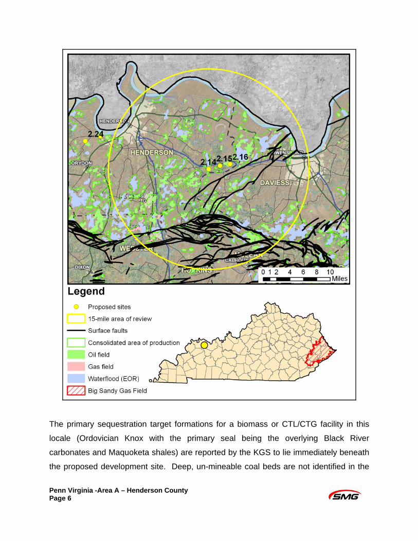
Solar
Adequate solar radiation is critical to the successful generation of solar power. A
successful site should be relatively free from land cover, and not within a mile of a
corporate city boundary. The Penn Virginia Area A site has an annual direct normal
solar radiation of 3.88 KWh/m2/day and an annual solar radiation for two-axis flat plates
of 6.18 KWh/m2/day. Based upon this average solar radiation, too much cloud cover
and haze is present to be effective as a large scale facility. The property is open land
except for the forested ridges. Solar installations in large mass can be a visual
distraction to local communities; however, this site is greater than a mile from an urban
community.
Solar insolation map
Penn Virginia -Area A – Henderson County
Page 13

Wind
The most critical component for a successful wind facility is adequate and consistent
wind speed. In order to generate enough power to be a utility class facility, a mean
average wind speed at 60 meters of 5.6 meters per second (m/s) or greater is required.
Information obtained from AWS Truewind, indicates that the average wind speed at 60
meters for the site is 5.27 m/s. Without adequate wind speed, other factors, such as
foundational concerns, potential visual impacts, telecommunication interference,
impacts to birds and bats, as well as operational concerns such as ice shedding, noise,
blade drop and throw, and flicker are moot. Wind speed measurements to accurately
assess the available resource at any potential development site would be required prior
to final planning.
Mean wind speed – 5.27 m/s
Penn Virginia -Area A – Henderson County Page 14

Biomass
An adequate feedstock supply environment includes available crop residues, animal
manure, forest residues from former silviculture or clearing, primary and secondary mill
residues, urban residues (i.e., wood scraps from local business such as lumberyards),
landfill gas, domestic wastewater, or switchgrass. Information obtained from the
National Renewable Energy Laboratory indicates that the total biomass available within
Henderson County is 127,465 tonnes/year. Biomass in Henderson and its surrounding
Counties is 829,150 tonnes/year. These supplies (>500,000 tonnes/year) are expected
to provide an adequate feedstock source. Analysis of the potential in the area to grow
feedstock specifically for a biomass facility should also be part of the planning process.
Nuclear
A limiting factor to the development of a nuclear facility is available water supply. The
lowest mean annual flow for this section of the Green River is 3,453 MGD, which is well
above the required 11.5 MGD to meet basic facility needs.
Safety issues associated with nuclear facilities include ensuring an adequate controlled
buffer zone of at least 2,000’ radius around the facility and an effective emergency plan.
These aspects mean that the best location for a nuclear facility is a rural, or
undeveloped site. The Penn Virginia Area A site has a controlled exclusion zone
greater than 3,000’, but is located 10 miles from a population center of 25,000 persons
or more. The emergency plan should take into account egress limitations that could
potentially impede emergency efforts. No obvious impediments to egress are present
within 50 miles of the site. From the site, egress on the Audubon Parkway can be taken
either east to Owensboro or west to Henderson. From either city, egress can continue
in the same direction or north and south using Hwy 431, Pennyrile Parkway, or Natcher
Parkway.
Atmospheric considerations can be important for a nuclear facility to avoid the possibility
for interaction of the nuclear cooling system plume with a plume containing noxious or
Penn Virginia -Area A – Henderson County Page 15

toxic substances from a nearby facility. The nearest air pollutant discharge source is a
source for air emissions six miles from the site.
SUITABILITY
In summary, the Penn Virginia Area A, located within the Western Kentucky Coal Fields,
is a viable site for a potential alternative energy facility, particularly a biomass or
CTL/CTG facility. The site scored a total of 1026 points, representing 86% of the total
available points for a CTL/CTG facility. Similarly, for a biomass facility, the site scored a
total of 1061 points, representing 85% of the total available points, with good
transportation and high biomass availability in the local area. The Penn Virginia A site
offers suitable location with excellent nearby coal resources, road and barge transport
accessibility, with adequate water resources and necessary workforce to construct and
operate the facility. Some additional improvement to basic utility access and connection
with high capacity natural gas and electricity may be required, but is possible. The site
developer will need to adequately assess natural and cultural resources and manage
the site to avoid negative impact to those resources
Due to a low average mean wind speed, this location is not a viable location for a utility
scale wind facility. Additionally, available solar radiation at the site is too low to produce
a significant source of energy for a utility solar facility alone, with a site score of 542
points, representing 58% of the total available points.
The site scored a total of 704 points for a potential nuclear facility, representing 73% of
the total available points. Prior to development of a nuclear facility, foundation concerns
and further geotechnical study would be required for earthquake stability.
Penn Virginia -Area A – Henderson County Page 16

Penn Virginia -Area A – Henderson County Page 17

Kentucky Department for Energy Development and Independence http://www.energy.ky.gov/
500 Metro Street 12th Floor, Capital Plaza Tower
Frankfort, KY 40601 (502) 564-7192 or (800) 282-0868
Smith Management Group www.smithmanage.com
1405 Mercer Road Lexington, KY 40511
(859) 213-8936
Penn Virginia Land Company 125 First Street
Suite 100 Henderson, KY 42420
(270) 546-0380