Embed Size (px)
Citation preview
Peoria Avenue Corridor Improvement Study:Jackrabbit Trail Parkway to Dysart Road
July 2011
Final Report
Final Report Peoria Avenue Corridor Improvement Study Jackrabbit Trail Parkway to Dysart Road
Page ES-1 July 2011
EXECUTIVE SUMMARY
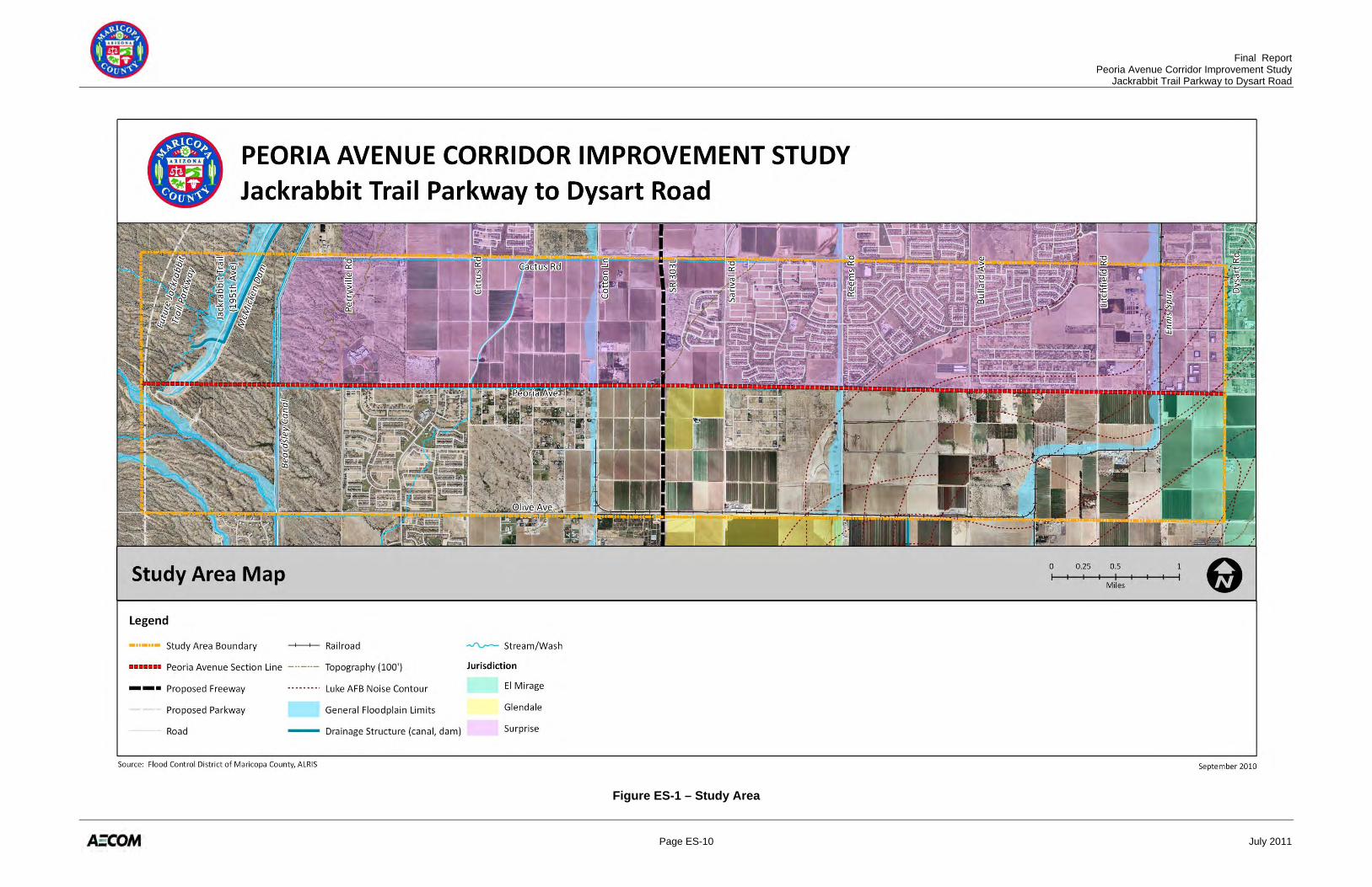
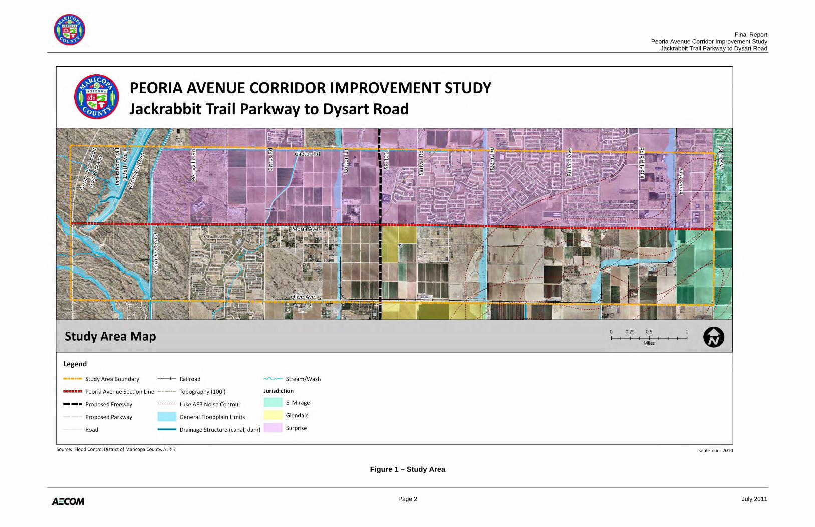
The Peoria Avenue Corridor Improvement Study: Jackrabbit Trail Parkway to Dysart Road is one in a series of long-range transportation planning studies being conducted by the Maricopa County Department of Transportation (MCDOT) to assess the ultimate corridor footprint requirements to enable consistent implementation across multiple jurisdictions. BACKGROUND The Maricopa Association of Governments (MAG) prepared the Interstate 10/Hassayampa Valley Roadway Framework Study (Hassayampa Framework Study) that identified a comprehensive roadway network to meet traffic demands for the build out of the area west of State Route 303 (SR 303L). This long range regional transportation study identified the need for a roadway network consisting of freeways, parkways, and major arterial roads. The Hassayampa Framework Study recommended an extension of Peoria Avenue west from Perryville Road to the future Jackrabbit Trail Parkway, and identified Peoria Avenue as a major arterial from the future Jackrabbit Trail Parkway to Sarival Avenue. The study area for this project includes Peoria Avenue from the future Jackrabbit Trail Parkway alignment to Dysart Road (Peoria Avenue Corridor). The study area generally encompasses a two-mile wide corridor centered on the existing Peoria Avenue. The study area is shown in Figure ES-1. PURPOSE, GOALS, AND OBJECTIVES The goal of this study is to establish the facility type, number of lanes, right-of-way needs, and general alignment for the Peoria Avenue Corridor that will be required to accommodate projected traffic growth and enhance safety. In cooperation with the City of Surprise, the City of Glendale, and the City of El Mirage, the study has also developed access management guidelines, determined design standards based upon which jurisdiction anticipates annexing the roadway, and developed an implementation plan. In general, the purpose of this Corridor Improvement Study is to provide MCDOT and other jurisdictions with a future “footprint” of the Peoria Avenue Corridor and a timeframe for the implementation of the recommended future roadway improvements. The key objectives of this Corridor Improvement Study include:
• Define and assess strategic issues within the project study area • Develop and evaluate conceptual alternative alignments within the corridor study area • Recommend a preferred alignment • Develop consensus for the preferred alignment • Define the characteristics of the preferred alignment • Develop an implementation plan
Final Report Peoria Avenue Corridor Improvement Study Jackrabbit Trail Parkway to Dysart Road
Page ES-2 July 2011
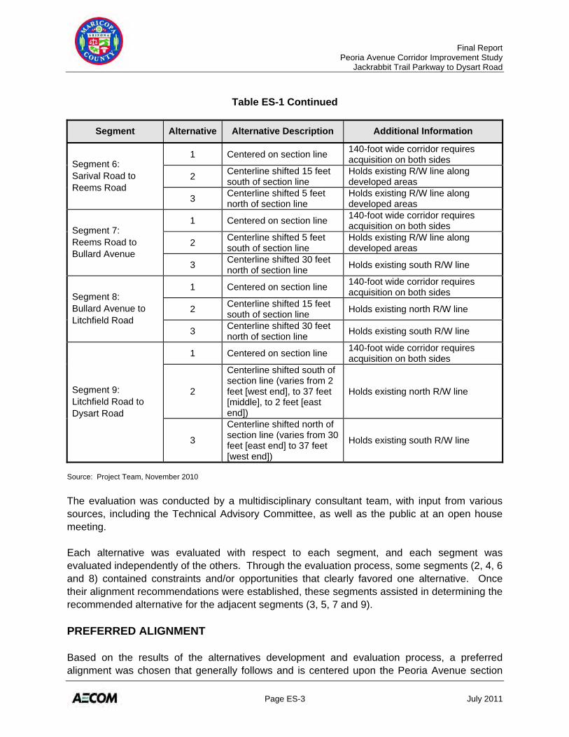
ALTERNATIVES DEVELOPMENT AND EVALUATION Three alternative alignments were considered for Peoria Avenue. For planning purposes, a 140-foot wide (minimum) corridor was used for each alternative. Alternative 1 includes widening the corridor symmetric about the section line. Alternative 2 includes widening the corridor to the south, maintaining the northern right-of-way boundary. Alternative 3 includes widening the corridor to the north, maintaining the southern right-of-way boundary. Because the existing right-of-way throughout the corridor differs due to varying dedications of land, the degree of shifting to the north or south changes. For example, in some areas a shift may represent a difference of only five feet; in others, a shift could represent a change of 55 feet. To help in the analysis, the Peoria Avenue corridor was divided into nine segments for the evaluation process. Table ES-1 describes the alignment of each alternative within each segment.
Table ES-1 – Alternative Alignment Descriptions
Segment Alternative Alternative Description Additional Information
Segment 1: Future Jackrabbit Trail Parkway to Beardsley Canal
1 Centered on section line Goes through basin and floodpool
2 South of reconstructed McMicken Dam Goes south of floodpool
Segment 2: Beardsley Canal to Perryville Road
1 Centered on section line Matches Zanjero Trails Preliminary Plat
Segment 3: Perryville Road to Citrus Road
1 Centered on section line 140-foot wide corridor requires acquisition on both sides
2 Centerline shifted 5 feet south of section line
Holds planned dedicated R/W along north side
3 Centerline shifted 15 feet north of section line Holds existing south R/W line
Segment 4: Citrus Road to Cotton Lane
1 Centered on section line 140-foot wide corridor requires acquisition on both sides
2 Centerline shifted 5 feet south of section line
Holds planned dedicated R/W along north side
3 Centerline shifted 37 feet north of section line
Places south R/W line approximately 10 feet south of irrigation ditch and allows room for potential frontage road
Segment 5: Cotton Lane to Sarival Road
1 Centered on section line
176-foot wide corridor requires acquisition on both sides; wider corridor adjacent to SR 303L/Peoria Avenue traffic interchange
2 Centerline shifted 55 feet south of section line Holds existing north R/W line
3 Centerline shifted 55 feet north of section line Holds existing south R/W line
Final Report Peoria Avenue Corridor Improvement Study Jackrabbit Trail Parkway to Dysart Road
Page ES-3 July 2011
Table ES-1 Continued
Segment Alternative Alternative Description Additional Information
Segment 6: Sarival Road to Reems Road
1 Centered on section line 140-foot wide corridor requires acquisition on both sides
2 Centerline shifted 15 feet south of section line
Holds existing R/W line along developed areas
3 Centerline shifted 5 feet north of section line
Holds existing R/W line along developed areas
Segment 7: Reems Road to Bullard Avenue
1 Centered on section line 140-foot wide corridor requires acquisition on both sides
2 Centerline shifted 5 feet south of section line
Holds existing R/W line along developed areas
3 Centerline shifted 30 feet north of section line Holds existing south R/W line
Segment 8: Bullard Avenue to Litchfield Road
1 Centered on section line 140-foot wide corridor requires acquisition on both sides
2 Centerline shifted 15 feet south of section line Holds existing north R/W line
3 Centerline shifted 30 feet north of section line Holds existing south R/W line
Segment 9: Litchfield Road to Dysart Road
1 Centered on section line 140-foot wide corridor requires acquisition on both sides
2
Centerline shifted south of section line (varies from 2 feet [west end], to 37 feet [middle], to 2 feet [east end])
Holds existing north R/W line
3
Centerline shifted north of section line (varies from 30 feet [east end] to 37 feet [west end])
Holds existing south R/W line
Source: Project Team, November 2010 The evaluation was conducted by a multidisciplinary consultant team, with input from various sources, including the Technical Advisory Committee, as well as the public at an open house meeting. Each alternative was evaluated with respect to each segment, and each segment was evaluated independently of the others. Through the evaluation process, some segments (2, 4, 6 and 8) contained constraints and/or opportunities that clearly favored one alternative. Once their alignment recommendations were established, these segments assisted in determining the recommended alternative for the adjacent segments (3, 5, 7 and 9). PREFERRED ALIGNMENT Based on the results of the alternatives development and evaluation process, a preferred alignment was chosen that generally follows and is centered upon the Peoria Avenue section
Final Report Peoria Avenue Corridor Improvement Study Jackrabbit Trail Parkway to Dysart Road
Page ES-4 July 2011
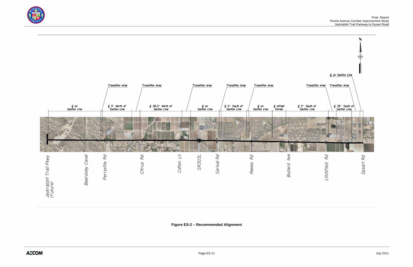
line except where existing constraints limit the corridor and warrant a slight alignment change. Transition areas are planned between alignment shifts to maintain corridor fluidity. The preferred alignment is illustrated in Figure ES-2. Typical Section The Peoria Avenue section line serves as a boundary between two jurisdictional agencies with different design standards – the City of Surprise to the north, and Maricopa County to the south. Without an executed operation and maintenance agreement in place, roadway designs and development plans will be reviewed and approved by one of the two different agencies, depending on whether the site is north or south of Peoria Avenue. Due to the differing design standards for a principal arterial, as well as differing corridor constraints, hybrid typical sections were developed for Peoria Avenue, including:
• Standard Hybrid Typical Section: Ultimate right-of-way width of 133 feet; north half-street reflects City of Surprise standard, south half-street reflects Maricopa County standard; would be utilized between Jackrabbit Trail Parkway and Perryville Road, Reems Road and Bullard Avenue, and Litchfield Road and Dysart Road.
• Narrow Typical Section: Ultimate right-of-way width of 120 feet; similar to Standard Hybrid Typical Section with reduced median widths and buffer distances; would be utilized between Perryville Road and Citrus Road, Sarival Road and Reems Road, and Bullard Avenue and Litchfield Road.
• Widened Hybrid Typical Section: Ultimate right-of-way width of 169 feet to accommodate the addition of turn lanes and/or auxiliary lanes near SR 303L; would be utilized between Cotton Lane and Sarival Road.
• Narrow Hybrid with Frontage Road Typical Section: Ultimate right-of-way with of 145 feet; designed as an access management strategy for residential properties with direct access to Peoria Avenue; would be utilized between Citrus Road and Cotton Lane.
Planning-Level Cost Estimates Preliminary planning-level cost estimates for the Preferred Alignment were developed with the following assumptions:
• 6-lane typical section • Two traffic signals per mile (every half-mile) • Underground signal equipment provided at quarter-mile locations • Traffic signal interconnection system for the entire length • No street lighting • 8-foot masonry sound wall adjacent to existing development (actual noise mitigation to
be based on future study at time of construction following current noise abatement policy)
• Eight driveways per mile, per side
Final Report Peoria Avenue Corridor Improvement Study Jackrabbit Trail Parkway to Dysart Road
Page ES-5 July 2011
• Minimal earthwork assuming roadway would be at or near existing ground • Remove and replace existing roadway features • On-site roadway drainage system includes catch basins spaced approximately every
500 feet that discharge into a drainage channel along the roadway • $4 per square foot for right-of-way acquisition
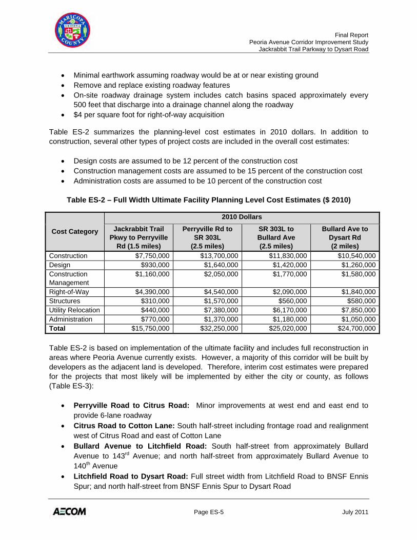
Table ES-2 summarizes the planning-level cost estimates in 2010 dollars. In addition to construction, several other types of project costs are included in the overall cost estimates:
• Design costs are assumed to be 12 percent of the construction cost • Construction management costs are assumed to be 15 percent of the construction cost • Administration costs are assumed to be 10 percent of the construction cost
Table ES-2 – Full Width Ultimate Facility Planning Level Cost Estimates ($ 2010)
Cost Category
2010 Dollars
Jackrabbit Trail Pkwy to Perryville
Rd (1.5 miles)
Perryville Rd to SR 303L
(2.5 miles)
SR 303L to Bullard Ave (2.5 miles)
Bullard Ave to Dysart Rd (2 miles)
Construction $7,750,000 $13,700,000 $11,830,000 $10,540,000Design $930,000 $1,640,000 $1,420,000 $1,260,000Construction Management
$1,160,000 $2,050,000 $1,770,000 $1,580,000
Right-of-Way $4,390,000 $4,540,000 $2,090,000 $1,840,000Structures $310,000 $1,570,000 $560,000 $580,000Utility Relocation $440,000 $7,380,000 $6,170,000 $7,850,000Administration $770,000 $1,370,000 $1,180,000 $1,050,000Total $15,750,000 $32,250,000 $25,020,000 $24,700,000
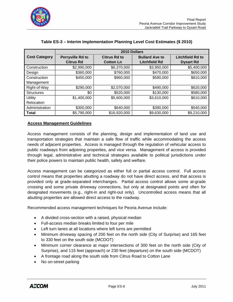
Table ES-2 is based on implementation of the ultimate facility and includes full reconstruction in areas where Peoria Avenue currently exists. However, a majority of this corridor will be built by developers as the adjacent land is developed. Therefore, interim cost estimates were prepared for the projects that most likely will be implemented by either the city or county, as follows (Table ES-3):
• Perryville Road to Citrus Road: Minor improvements at west end and east end to provide 6-lane roadway
• Citrus Road to Cotton Lane: South half-street including frontage road and realignment west of Citrus Road and east of Cotton Lane
• Bullard Avenue to Litchfield Road: South half-street from approximately Bullard Avenue to 143rd Avenue; and north half-street from approximately Bullard Avenue to 140th Avenue
• Litchfield Road to Dysart Road: Full street width from Litchfield Road to BNSF Ennis Spur; and north half-street from BNSF Ennis Spur to Dysart Road
Final Report Peoria Avenue Corridor Improvement Study Jackrabbit Trail Parkway to Dysart Road
Page ES-6 July 2011
Table ES-3 – Interim Implementation Planning Level Cost Estimates ($ 2010)
Cost Category 2010 Dollars
Perryville Rd to Citrus Rd
Citrus Rd to Cotton Ln
Bullard Ave to Litchfield Rd
Litchfield Rd to Dysart Rd
Construction $2,990,000 $6,370,000 $3,950,000 $5,400,000Design $360,000 $760,000 $470,000 $650,000Construction Management
$450,000 $960,000 $590,000 $810,000
Right-of-Way $290,000 $2,070,000 $490,000 $620,000Structures $0 $520,000 $130,000 $580,000Utility Relocation
$1,400,000 $5,600,000 $3,610,000 $610,000
Administration $300,000 $640,000 $390,000 $540,000Total $5,790,000 $16,920,000 $9,630,000 $9,210,000 Access Management Guidelines Access management consists of the planning, design and implementation of land use and transportation strategies that maintain a safe flow of traffic while accommodating the access needs of adjacent properties. Access is managed through the regulation of vehicular access to public roadways from adjoining properties, and vice versa. Management of access is provided through legal, administrative and technical strategies available to political jurisdictions under their police powers to maintain public health, safety and welfare. Access management can be categorized as either full or partial access control. Full access control means that properties abutting a roadway do not have direct access, and that access is provided only at grade-separated interchanges. Partial access control allows some at-grade crossing and some private driveway connections, but only at designated points and often for designated movements (e.g., right-in and right-out only). Uncontrolled access means that all abutting properties are allowed direct access to the roadway. Recommended access management techniques for Peoria Avenue include:
• A divided cross-section with a raised, physical median • Full-access median breaks limited to four per mile • Left turn lanes at all locations where left turns are permitted • Minimum driveway spacing of 200 feet on the north side (City of Surprise) and 165 feet
to 330 feet on the south side (MCDOT) • Minimum corner clearance at major intersections of 300 feet on the north side (City of
Surprise), and 115 feet (approach) or 230 feet (departure) on the south side (MCDOT) • A frontage road along the south side from Citrus Road to Cotton Lane • No on-street parking
Final Report Peoria Avenue Corridor Improvement Study Jackrabbit Trail Parkway to Dysart Road
Page ES-7 July 2011
Development policies intended to help achieve access management that can be implemented through future development and redevelopment include:
• Encourage alternative access ways that connect to Peoria Avenue at identified major access points
• Encourage on-site circulation or parallel routes that would discourage direct access to Peoria Avenue
• Encourage the use of direct access to minor roadways connecting to the corridor • Minimize the number of driveways to reduce traffic conflicts
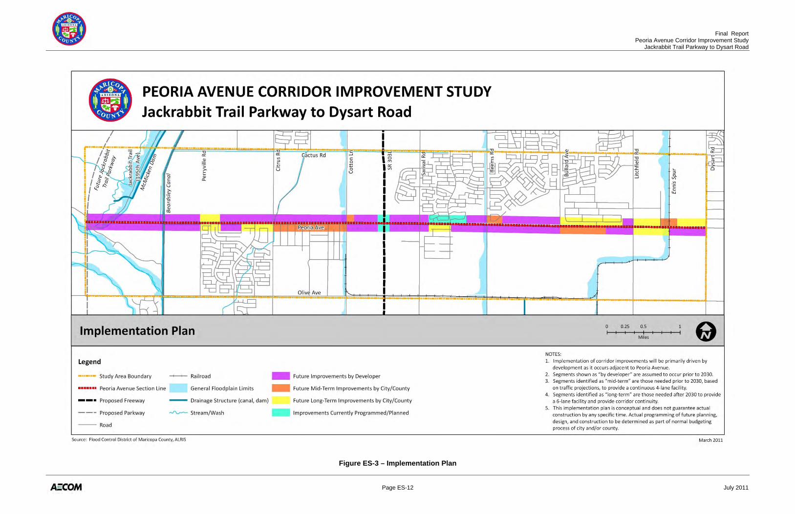
Implementation Plan The recommendations of this study are intended to be used to preserve corridor right-of-way since construction of improvements will not likely be completed in the near-term, but rather as development occurs along the corridor, as shown in Figure ES-3. All timetables are subject to change, depending on such circumstances as identification of additional funding, new opportunities for cost-sharing with partner jurisdictions, and development of land adjacent to Peoria Avenue. In the near-term, projects that are already programmed should be completed, such as improvements at the SR 303L/Peoria Avenue interchange to be constructed by ADOT when SR 303L is upgraded to a freeway facility, as well as the City of Surprise planned completion of the north half-street between Sarival and Reems Roads. Other near-term improvements recommended for consideration include:
• Acquire right-of-way and construct a two-lane roadway between Citrus Road and Cotton Lane
• Drainage improvements at Litchfield and Sarival Roads Assuming completion of the segments to be implemented by developers, several additional improvement projects would be needed in the mid-term timeframe to provide a continuous 4-lane facility by the year 2030, including:
• South half-street and frontage road construction between Citrus Road and Cotton Lane • Cotton Lane intersection improvements • Reems Road intersection improvements • South half-street construction between Bullard Avenue and Litchfield Road • South half-street construction between Litchfield Road and BNSF Ennis Spur
Final Report Peoria Avenue Corridor Improvement Study Jackrabbit Trail Parkway to Dysart Road
Page ES-8 July 2011
Long-term (likely beyond 2030) improvements will focus on bringing uniformity to the corridor and widening to the ultimate 6-lane facility. Areas where these improvements would occur include:
• Perryville Road to Citrus Road • Sarival Road to Reems Road • Bullard Road to Litchfield Road • Litchfield Road to Dysart Road
The MCDOT Transportation Improvement Program (TIP), updated annually, is based on a 5-year projection of available transportation funding and a countywide prioritization of roadway system needs. No projects (Design Concept Report, design, or construction) along this portion of Peoria Avenue are a part of the current 5-year TIP. CONSIDERATIONS FOR FUTURE STUDY AND DESIGN Arizona State Land Department Holding West of Beardsley Canal The west end of the corridor from Jackrabbit Trail Parkway to Beardsley Canal is owned by the Arizona State Land Department (ASLD). These State Trust Lands will likely be sold or leased to private interests for development. At such time, a detailed land development plan will be developed, including roadway alignments. The Preferred Alignment for Peoria Avenue is coincident with the section line in this segment. However, future development plans could result in a different alignment for Peoria Avenue as long as the connection to Jackrabbit Trail Parkway is maintained and connectivity to the east is provided. The Preferred Alignment crosses a flood retention basin owned by the Flood Control District of Maricopa County (FCDMC). A FCDMC right-of-way use permit would be required for any improvements that are located on their property. Future coordination will be required with FCDMC on all studies and design efforts pertaining to this proposed roadway alignment. The roadway must not impact the safety and function of the existing FCDMC facilities and associated basin, channel, and dam. For example, the proposed roadway must not reduce the existing basin volume or adversely impact existing flow conveyance. In addition, all FCDMC requirements pertaining to operations and maintenance, environment, and land rights must be met. Citrus Road to Cotton Lane Between Citrus Road and Cotton Lane, the Preferred Alignment includes a shift to the north and the construction of a frontage road along the south side of Peoria Avenue. The Preferred Alignment would require approximately 100 feet of right-of-way north of the section line. The planned Prasada development within the City of Surprise contained provisions for a landscape buffer along the north side of Peoria Avenue to accommodate a drainage channel. With the proposed Peoria Avenue shift to the north, a portion of the planned landscape buffer would be
Final Report Peoria Avenue Corridor Improvement Study Jackrabbit Trail Parkway to Dysart Road
Page ES-9 July 2011
occupied by Peoria Avenue. Further investigation is required to determine the necessary drainage channel configuration and landscape configuration. This unpaved one-mile segment of the corridor generated the most interest from the public during the open house meetings conducted during this study. The primary feedback was to immediately implement improvements to mitigate dust issues, and to place the ultimate roadway as far north as possible. In addition, concern was expressed regarding vehicle speeds along Peoria Avenue adjacent to the homes along the south side, with a strong desire for a reduced speed limit (below 40 miles per hour) within this segment. In addition, the public requested to limit the number of connections to the frontage road from the south, such that some of the existing north-south streets would not connect to the frontage road. A future box culvert crossing under Citrus Road is planned north of Peoria Avenue. This crossing will be in conflict with the existing Maricopa Water District (MWD) Cross-Cut Canal. Future design and coordination efforts will be needed to address this crossing. Realignment West of Bullard Avenue West of Bullard Avenue, the Preferred Alignment includes a northerly shift near the center of the segment to avoid the existing irrigation facilities and well sites. If corridor conditions change in the future (e.g., removal of the irrigation facilities on the south side or new development on the north side) this recommendation should be reconsidered. For example, if development occurs first on the south side of Peoria Avenue, the existing irrigation facilities would likely be relocated as part of the development. If this were the case, then the alignment could stay on the section line and the realignment would not be necessary. However, if development were to occur first on the north side of Peoria Avenue, then the northerly shift should be implemented to avoid relocation of the irrigation facilities. BNSF Ennis Spur The existing BNSF Ennis Spur crossing of Peoria Avenue is at-grade and proposed improvements maintain the at-grade crossing. Future development plans near the BNSF Ennis Spur should provide building set-backs to allow the future implementation of a grade separated crossing, if deemed necessary in the future.
Final Report Peoria Avenue Corridor Improvement Study Jackrabbit Trail Parkway to Dysart Road
Page ES-10 July 2011
Figure ES-1 – Study Area
Final Report Peoria Avenue Corridor Improvement Study Jackrabbit Trail Parkway to Dysart Road
Page ES-11 July 2011
Figure ES-2 – Recommended Alignment
Final Report Peoria Avenue Corridor Improvement Study Jackrabbit Trail Parkway to Dysart Road
Page ES-12 July 2011
Figure ES-3 – Implementation Plan
Final Report Peoria Avenue Corridor Improvement Study Jackrabbit Trail Parkway to Dysart Road
Page 1 July 2011
1.0 INTRODUCTION
The Maricopa Association of Governments (MAG) prepared the Interstate 10/Hassayampa Valley Roadway Framework Study (Hassayampa Framework Study) that identified a comprehensive roadway network to meet traffic demands for the build out of the area west of State Route 303 (SR 303L). This long range regional transportation study identified the need for a roadway network consisting of freeways, parkways, and major arterial roads. The Hassayampa Framework Study recommended an extension of Peoria Avenue west from Perryville Road to the future Jackrabbit Trail Parkway, and identified Peoria Avenue as a major arterial from the future Jackrabbit Trail Parkway to Sarival Avenue. The study area for this project includes Peoria Avenue from the future Jackrabbit Trail Parkway alignment to Dysart Road (Peoria Avenue Corridor). The study area generally encompasses a two-mile wide corridor centered on the existing Peoria Avenue. The study area is shown in Figure 1. The goal of this study is to establish the facility type, number of lanes, right-of-way needs, and general alignment for the Peoria Avenue Corridor that will be required to accommodate projected traffic growth and enhance safety. In cooperation with the City of Surprise, the City of Glendale, and the City of El Mirage, the study has also developed access management guidelines, determined design standards based upon which jurisdiction anticipates annexing the roadway, and developed an implementation plan. In general, the purpose of this Corridor Improvement Study is to provide the Maricopa County Department of Transportation (MCDOT) and other jurisdictions with a future “footprint” of the Peoria Avenue Corridor and a timeframe for the implementation of the recommended future roadway improvements. The key objectives of this Corridor Improvement Study include:
• Define and assess strategic issues within the project study area • Develop and evaluate conceptual alternative alignments within the corridor study area • Recommend a preferred alignment • Develop consensus for the preferred alignment • Define the characteristics of the preferred alignment • Develop an implementation plan
This report summarizes the findings of the project, with full technical memoranda located in the report’s appendices.
Final Report Peoria Avenue Corridor Improvement Study Jackrabbit Trail Parkway to Dysart Road
Page 2 July 2011
Figure 1 – Study Area
Final Report Peoria Avenue Corridor Improvement Study Jackrabbit Trail Parkway to Dysart Road
Page 3 July 2011
2.0 EXISTING AND FUTURE CORRIDOR FEATURES
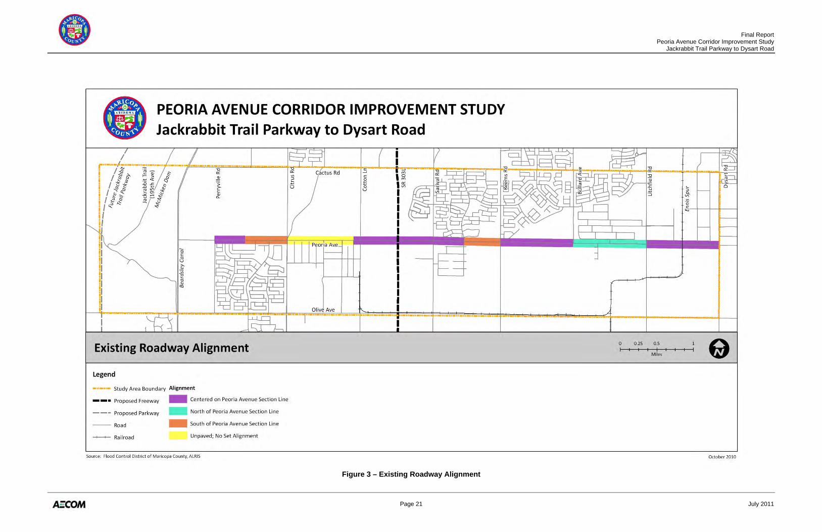
This section summarizes information gathered and documented in Technical Memorandums No. 1: Existing and Future Corridor Features, No. 2: Environmental Overview, No. 3: Conceptual Drainage Report, and No. 7: Traffic Analysis. The full text for these technical memoranda can be found in Appendices A, B, C, and G of this Report. Key exhibits are provided to graphically display the existing and future corridor features that were considered in identifying and evaluating feasible candidate corridor alternatives. 2.1 EXISTING TRANSPORTATION NETWORK Figure 2 illustrates the existing transportation network in the study area. Peoria Avenue is a two-lane roadway, with varying degrees of improvements. Peoria Avenue extends west as far as Perryville Road as a paved road, with the exception of a one-mile segment between Citrus Road and Cotton Lane that is unpaved. Between Perryville Road and the Beardsley Canal, an unpaved and narrow maintenance/access road exists. The existing roadway currently has a speed limit of 45 miles per hour, with no designated parking lanes or bicycle lanes along the roadway. Sidewalks (primarily detached) are located at various locations along the route where curb and gutter exist. In the wider context of the study area, Jackrabbit Trail Parkway does not yet exist; Olive Avenue is the only crossing of the Beardsley Canal providing access to the west; and SR 303L remains a major arterial road with no freeway improvements completed. Local roadways are intermittently developed, depending on the degree of built residential and industrial land uses. The BNSF Ennis Spur crosses Peoria Avenue at an at-grade railroad crossing, protected by lights and gates. 2.1.1 Roadway Classification Based on its current function in the existing network, MCDOT functionally classifies the existing Peoria Avenue roadway as a major collector in the Maricopa County Transportation System Plan (February 2007). A major collector provides short-distance (less than three miles) traffic movement, collects and distributes traffic between local and arterial streets, and provides direct access to abutting land. 2.1.2 Existing Alignment The current roadway alignment generally follows the Peoria Avenue section line, with some variation (Figure 3). The segments that are centered on the section line include: between Perryville Road and a half-mile east, between a quarter-mile west of Cotton Lane and a half-mile east of Sarival Road, between Reems Road and Bullard Avenue, and between Litchfield Road and Dysart Road. The existing roadway shifts slightly to the south so that the Peoria Avenue section line is near the north edge of the existing roadway between a half-mile east of
Final Report Peoria Avenue Corridor Improvement Study Jackrabbit Trail Parkway to Dysart Road
Page 4 July 2011
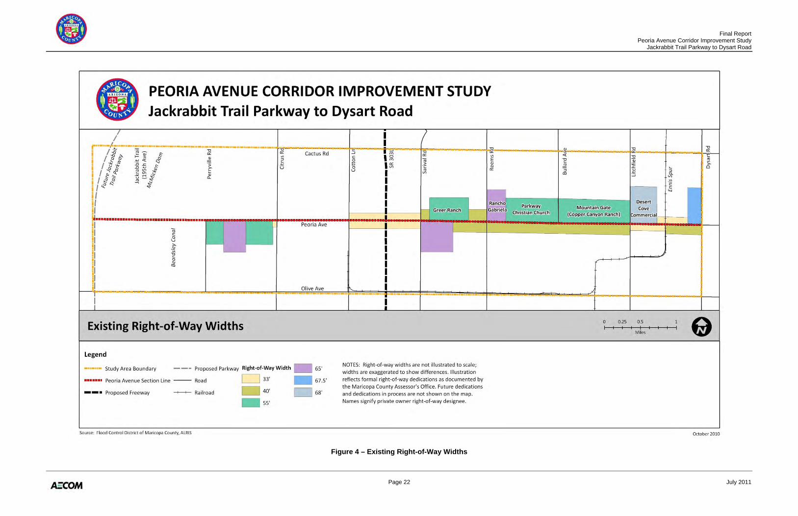
Perryville Road and Citrus Road, and between a half-mile east of Sarival Road and Reems Road. Between Bullard Avenue and Litchfield Road, the existing roadway shifts slightly to the north so that the Peoria Avenue section line is near the south edge of the existing roadway. 2.1.3 Existing Right-of-Way The existing right-of-way width along Peoria Avenue varies along the corridor. Figure 4 provides representative right-of-way width information along Peoria Avenue from Perryville Road to Dysart Road. It is important to note that information presented on this map includes formally recorded right-of-way per the Maricopa County Assessor’s Office, as of September 2010. This does not reflect right-of-way dedications that may be in process, municipality required developer stipulations that have not been administered, or any other situations not documented with the county. 2.1.4 Intersection and Lane Geometry The existing portion of Peoria Avenue within the study area has eight major cross-street intersections from Perryville Road to Dysart Road. The intersection with Litchfield Road is a four-legged signal controlled intersection. The other seven intersections are either two-way stop controlled or all-way stop controlled. The Perryville Road intersection is a “T” intersection, with the existing Peoria Avenue terminating here. 2.1.5 Access Conditions
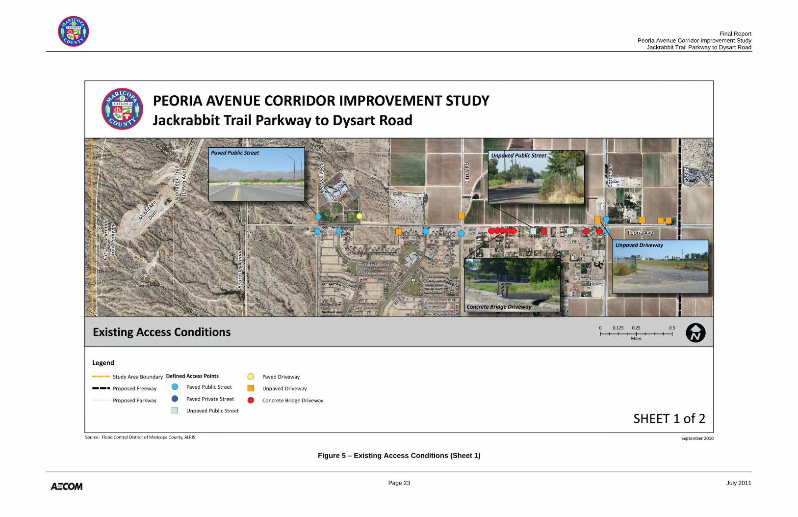
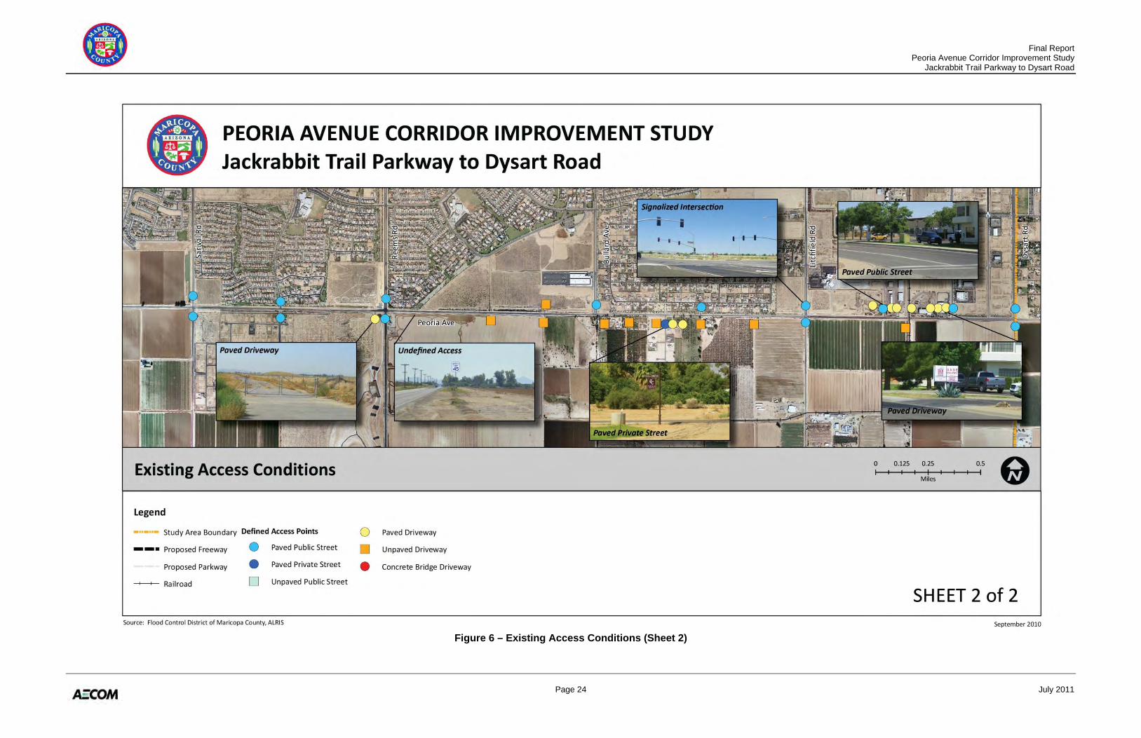
There are thirty-four driveways and fifteen intersections on Peoria Avenue. In addition to these defined access points, there is also “undefined” access throughout the corridor at various locations. All of the intersections have full access configurations, but only a few have separate lanes for left and right turns. The approximate locations of these minor intersections and driveways are shown in Figures 5 and 6. The figures include example photos of the various types of access conditions that are present along the corridor. All intersections and driveways along existing Peoria Avenue have full movement access in all directions (no limited access). 2.2 FUTURE TRANSPORTATION NETWORK For the planned future network, functional classification is the process by which roads are grouped into classes or systems according to the kind of service they will provide in the future. Roadways functionally classified as high-speed, high-capacity facilities tend to maximize mobility and minimize direct land access. The hierarchy of functional classification typically includes freeways, expressways, parkways, major and minor arterials, collectors, and local streets. Maricopa County and MAG similarly classify Peoria Avenue as an urban principal arterial in the future network. However, Peoria Avenue actually falls within multiple jurisdictions in the study area. Each jurisdiction has assigned its own future functional classification to the portion of
Final Report Peoria Avenue Corridor Improvement Study Jackrabbit Trail Parkway to Dysart Road
Page 5 July 2011
Peoria Avenue within its boundaries. The overlapping classifications are even more complex where Peoria Avenue forms the boundary between jurisdictions. For the planned future network, Peoria Avenue has been classified by local jurisdictions as listed below:
• MCDOT – Urban Principal Arterial: The future MCDOT functional classification of Peoria Avenue in the study area is as an urban principal arterial, as stated in the Maricopa County Major Streets and Routes Plan, adopted in 2001 and revised in 2004. A principal arterial is defined as a street that provides for long-distance traffic movement within Maricopa County or between Maricopa County and urban areas. Access to abutting land is restricted and controlled through frontage roads and raised medians, as well as by the spacing and location of driveways and intersections. Opposing traffic flows may be separated by a raised median.
• MAG – Major Arterial: The MAG Hassayampa Framework Study identifies Peoria Avenue as a major arterial. This is supported in the 2010 MAG Regional Transportation Plan (RTP).
• City of El Mirage – Minor Arterial: Incorporated El Mirage includes the area south of Peoria Avenue between the BNSF Ennis Spur and Dysart Road. El Mirage classifies Peoria Avenue as a minor arterial (based on City of Peoria standard details).
• City of Glendale – Major Arterial: The City of Glendale maintains planning jurisdiction over the south side of Peoria Avenue from the BNSF Ennis Spur to Perryville Road as part of its municipal planning area (MPA). One-half mile between SR 303L and Sarival Road is incorporated, fronting Peoria Avenue to the south. Recent General Plan amendments have upgraded Peoria Avenue to a major arterial roadway.
• City of Surprise – Major Arterial: The City of Surprise incorporated area within the study area extends north from Peoria Avenue, between the Beardsley Canal and Dysart Road. Surprise classifies Peoria Avenue as a major arterial in the current General Plan.
Much of the surrounding roadway system to the project area does not exist or is planned to be expanded or adjusted from its current configuration. SR 303L and Jackrabbit Trail Parkway are the two most significant roadway facilities in the surrounding network that will provide regional access.
• SR 303L Corridor: SR 303L is located roughly in the center of the study area. It intersects Peoria Avenue between Cotton Lane and Sarival Road. SR 303L is currently being improved from an interim two-lane roadway into a “Rural Major Freeway,” as classified by MAG. The ultimate improved SR 303L will be a fully access-controlled, grade-separated freeway. Peoria Avenue is one of the thirteen service interchanges planned for the build out of the SR 303L corridor.
Final Report Peoria Avenue Corridor Improvement Study Jackrabbit Trail Parkway to Dysart Road
Page 6 July 2011
• Jackrabbit Trail Parkway: Jackrabbit Trail Parkway has recently undergone several planning and corridor-level studies. In the 2007 MAG Hassayampa Framework Study, Jackrabbit Trail was established as an Arizona Parkway, a new functional classification category in Arizona. In 2008, MCDOT completed the Jackrabbit Trail Access Control and Corridor Improvement Study, which further refined the corridor and established a preferred alignment.
Jackrabbit Trail Parkway will follow the new Design Guideline Recommendations for the Arizona Parkway (MCDOT, August 2008), which includes an intermediate-capacity, six- to eight-lane divided highway with partial access control and no direct left turns permitted at major intersections. The junction of Peoria Avenue with Jackrabbit Trail Parkway will need to consider the design standards in the Arizona Parkway Intersection/Interchange Operational Analysis and Design Concepts Study (MCDOT, August 2009).
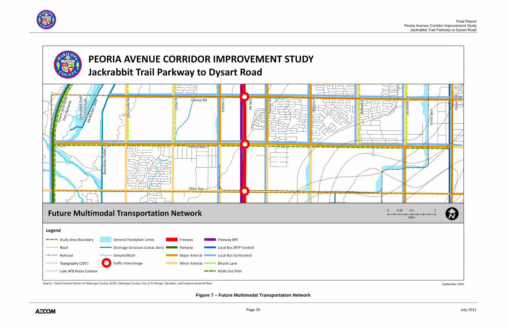
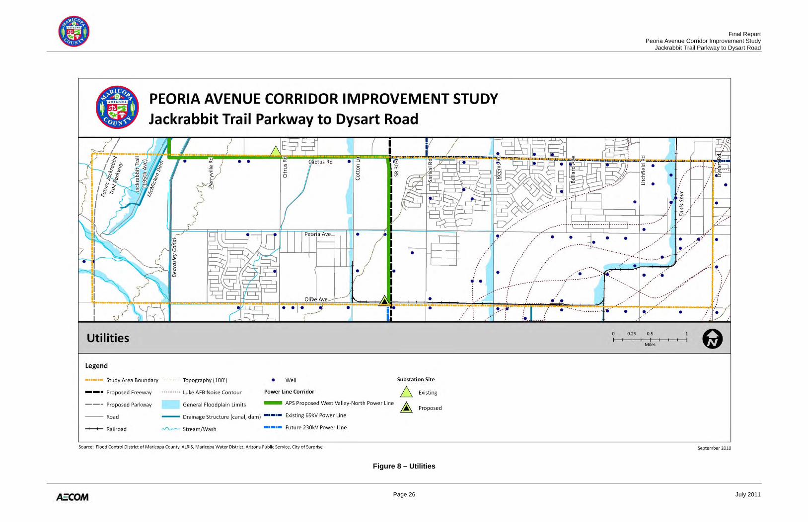
Figure 7 illustrates the future multimodal transportation network in the study area, including future roadway classifications, planned public transit routes and bicycle lanes/multi-use pathways. 2.3 UTILITIES Numerous utilities are present within the study area (Figure 8). The portion of the study area between the Beardsley Canal and Reems Road is within the Maricopa Water District (MWD) Conservation District Number One service area boundaries. MWD is primarily an irrigation water conservation district providing water services to its customers. The District’s irrigation conveyance and delivery channels and pipelines span the entire length of its service areas along Peoria Avenue. Many MWD wells and private irrigation wells (active and inactive) are also sited along Peoria Avenue. Under a contract with Arizona Public Service (APS), MWD also delivers power and energy through APS’s distribution facilities to water wells belonging to the District and its customers. Numerous overhead power distribution lines run in an east-west direction parallel to Peoria Avenue, along both sides of the roadway, as well as in a north-south direction along the cross streets: Cotton Lane, Sarival Avenue, Dysart Road, and the BNSF Ennis Spur. Aboveground power lines along Peoria Avenue are fragmented, a result of gradual burying of overhead distribution lines in front of new housing developments over the years. The future APS West Valley-North 230kV power transmission line, scheduled to be placed in service in 2015 in a corridor west of SR 303L, follows SR 303L from Olive Avenue to Cactus Road through the study area, where it will then turn west to parallel Cactus Road to the north. Power substation sites are planned on the adjacent major arterials to Peoria Avenue (Olive Avenue and Cactus Road). City utilities along Peoria Avenue include underground water and sewer lines, and appurtenances, including a 30-inch reclaimed water line and reclaimed water delivery headers on the south side of Peoria Avenue across from the City of Surprise South Water Reclamation Plant (SSWRP). Other public utilities along Peoria Avenue include Southwest Gas natural gas lines and Qwest overhead and underground telephone lines.
Final Report Peoria Avenue Corridor Improvement Study Jackrabbit Trail Parkway to Dysart Road
Page 7 July 2011
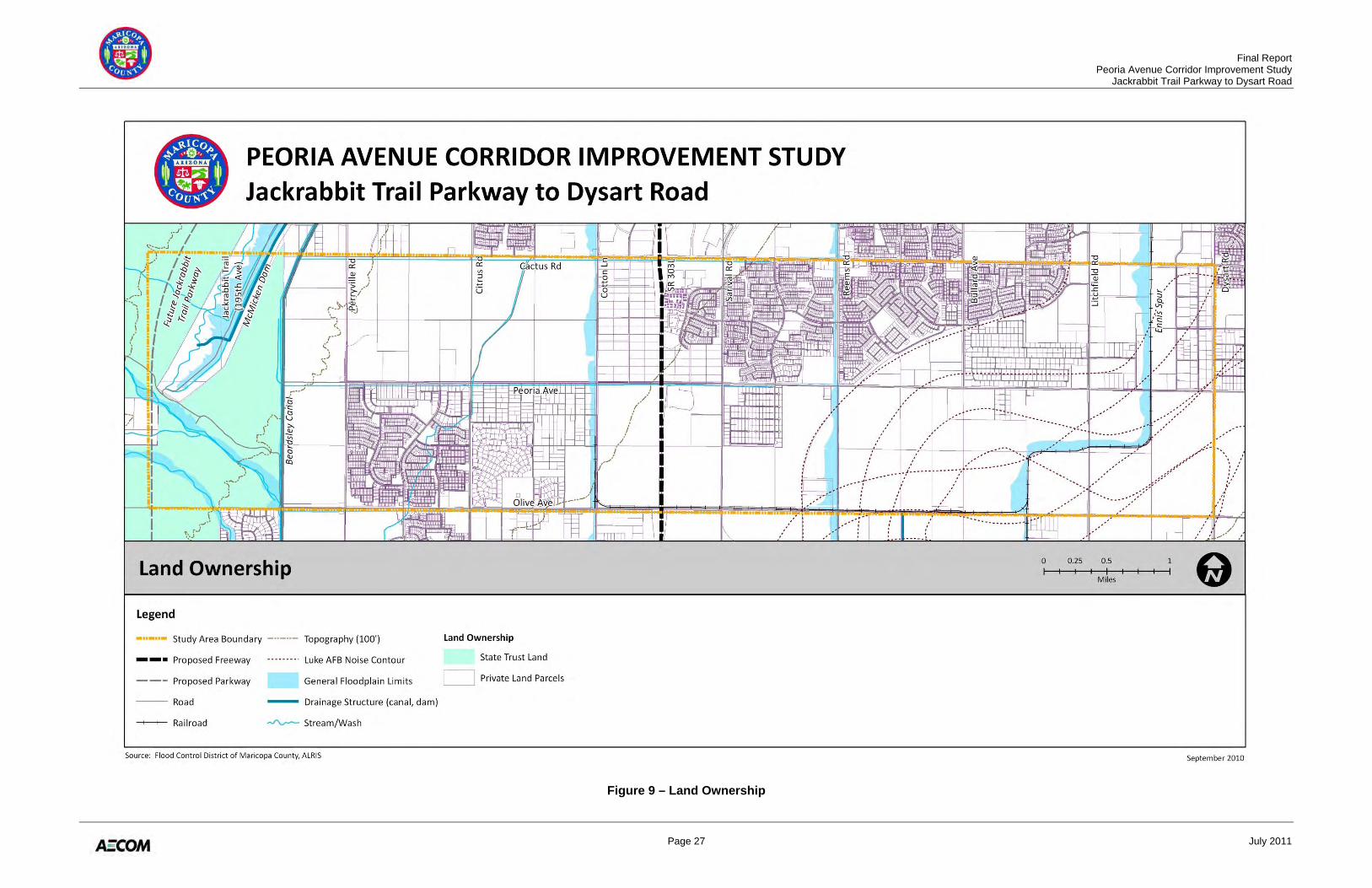
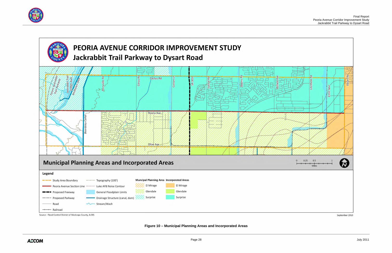
2.4 LAND USE, OWNERSHIP, AND MANAGEMENT Land ownership is identified in terms of public or private control, whereas land jurisdiction refers to the city, town, county, state, or federal agency or agencies exercising governmental authority over an area. The majority of the land in the study area is privately owned, with only about 20 percent of the westernmost study area publicly owned by the Arizona State Land Department (ASLD) (Figure 9). While much of the private land is parceled out and owned by individual property owners, there are several major private land holdings in the study area, including the Flood Control District of Maricopa County (FCDMC), MWD, and Dysart Unified School District #89, as well as major master planned community land owners. Figure 10 depicts the boundaries of all the jurisdictions and their MPAs within the study area: City of El Mirage, City of Glendale, and City of Surprise. Peoria Avenue serves as the boundary between the Glendale and Surprise MPAs. Maricopa County has planning and zoning authority over the unincorporated areas, including areas inside an MPA but outside the current city limits. The MPAs of El Mirage and Surprise are largely incorporated in the study area, while the areas in the Glendale MPA are mostly unincorporated, with the exception of a parcel abutting SR 303L and a 10-foot strip of land along the south side of Peoria Avenue from Perryville Road to east of Litchfield Road. This annexation is part of the City of Glendale Strip Annex Area which includes approximately 39 square miles of land, with Peoria Avenue serving as the northern boundary. Within the Glendale MPA, Maricopa County Planning and Development Department administers the zoning and subdivision ordinances. Table 1 notes the extent of the study area in each MPA, as well as the remaining land within the county.
Table 1 – Study Area by MPA
MPA/Jurisdiction Area (acres)
Percent of Study Area
El Mirage 320 3% Glendale 4,160 38% Surprise 5,440 50% Maricopa County 960 9% Total 10,880 100% Source: Flood Control District of Maricopa County.
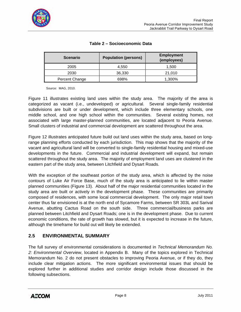
In 2005, the study area had a population of approximately 4,550 persons and an employment base of approximately 1,500 employees. By 2030, these numbers are expected to dramatically increase. Table 2 presents the socioeconomic data for the existing 2005 and adopted 2030 forecast scenarios, as well as the percent change between the two forecast years.
Final Report Peoria Avenue Corridor Improvement Study Jackrabbit Trail Parkway to Dysart Road
Page 8 July 2011
Table 2 – Socioeconomic Data
Scenario Population (persons) Employment (employees)
2005 4,550 1,500 2030 36,330 21,010
Percent Change 698% 1,300% Source: MAG, 2010.
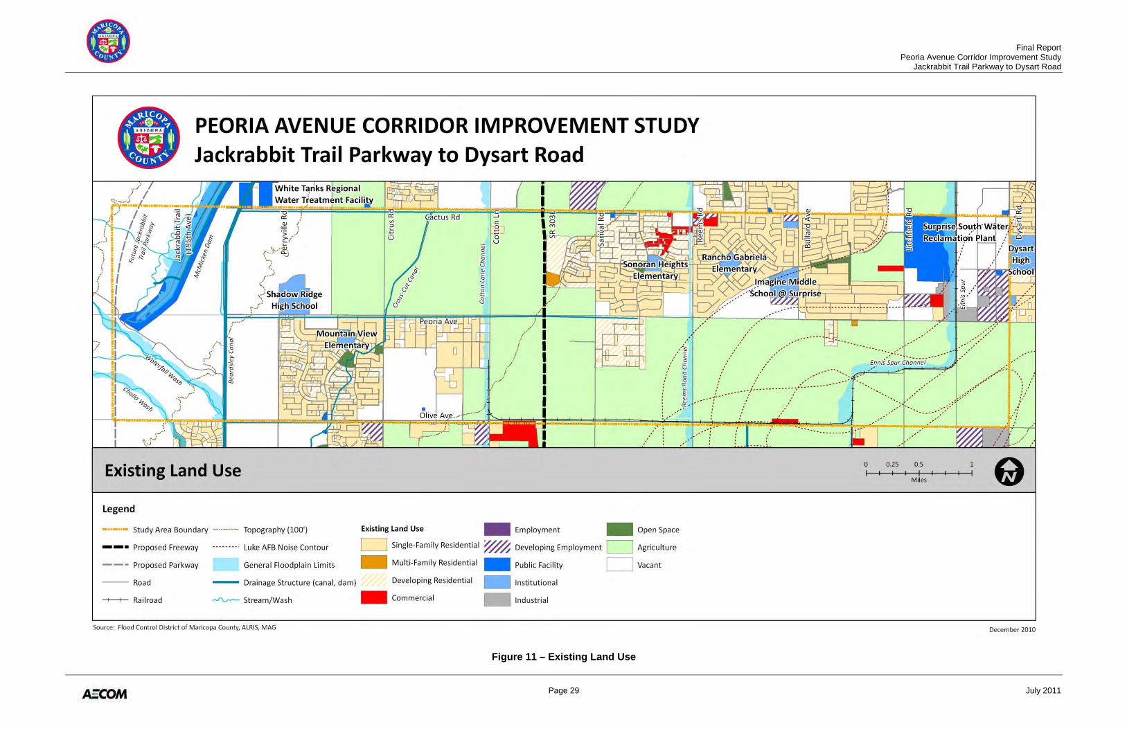
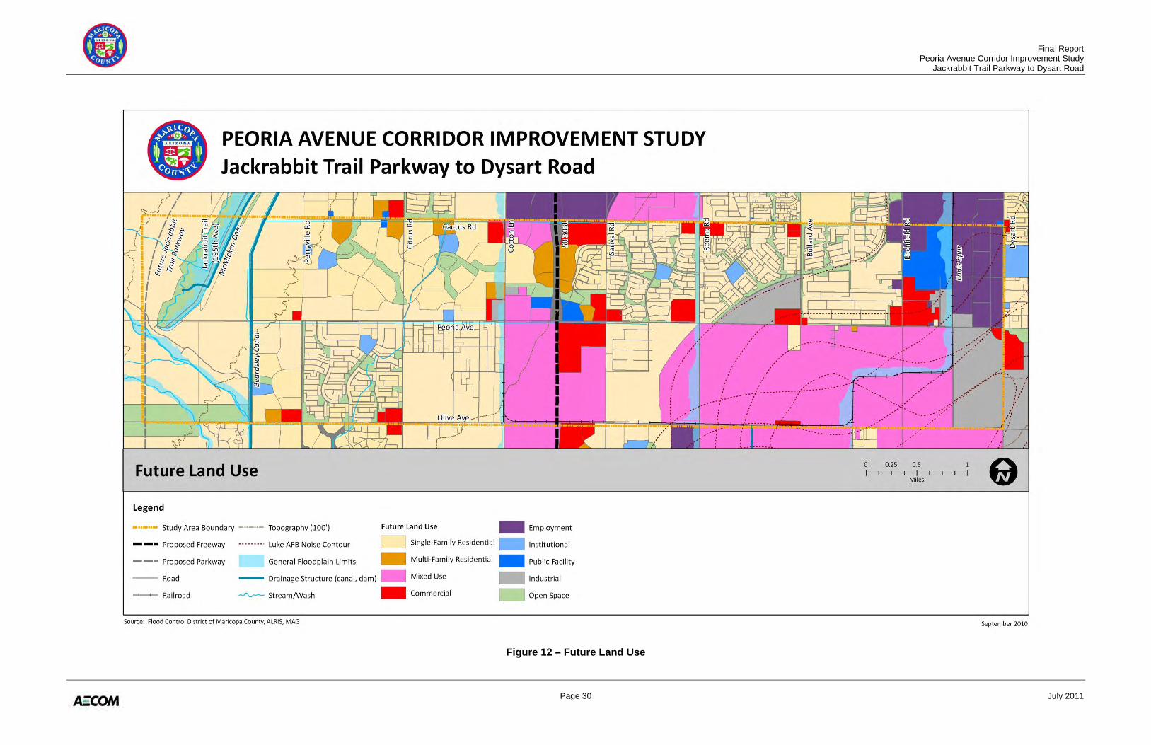
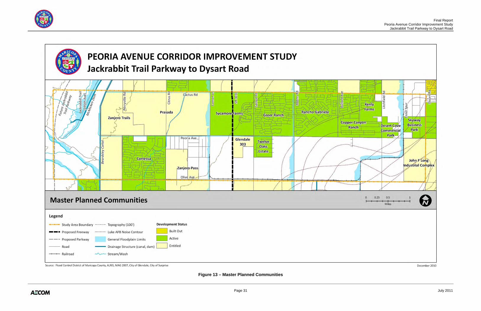
Figure 11 illustrates existing land uses within the study area. The majority of the area is categorized as vacant (i.e., undeveloped) or agricultural. Several single-family residential subdivisions are built or under development, which include three elementary schools, one middle school, and one high school within the communities. Several existing homes, not associated with large master-planned communities, are located adjacent to Peoria Avenue. Small clusters of industrial and commercial development are scattered throughout the area. Figure 12 illustrates anticipated future build out land uses within the study area, based on long-range planning efforts conducted by each jurisdiction. This map shows that the majority of the vacant and agricultural land will be converted to single-family residential housing and mixed-use developments in the future. Commercial and industrial development will expand, but remain scattered throughout the study area. The majority of employment land uses are clustered in the eastern part of the study area, between Litchfield and Dysart Roads. With the exception of the southeast portion of the study area, which is affected by the noise contours of Luke Air Force Base, much of the study area is anticipated to lie within master planned communities (Figure 13). About half of the major residential communities located in the study area are built or actively in the development phase. These communities are primarily composed of residences, with some local commercial development. The only major retail town center thus far envisioned is at the north end of Sycamore Farms, between SR 303L and Sarival Avenue, abutting Cactus Road on the south side. Three commercial/business parks are planned between Litchfield and Dysart Roads; one is in the development phase. Due to current economic conditions, the rate of growth has slowed, but it is expected to increase in the future, although the timeframe for build out will likely be extended. 2.5 ENVIRONMENTAL SUMMARY The full survey of environmental considerations is documented in Technical Memorandum No. 2: Environmental Overview, located in Appendix B. Many of the topics explored in Technical Memorandum No. 2 do not present obstacles to improving Peoria Avenue, or if they do, they include clear mitigation actions. The more significant environmental issues that should be explored further in additional studies and corridor design include those discussed in the following subsections.
Final Report Peoria Avenue Corridor Improvement Study Jackrabbit Trail Parkway to Dysart Road
Page 9 July 2011
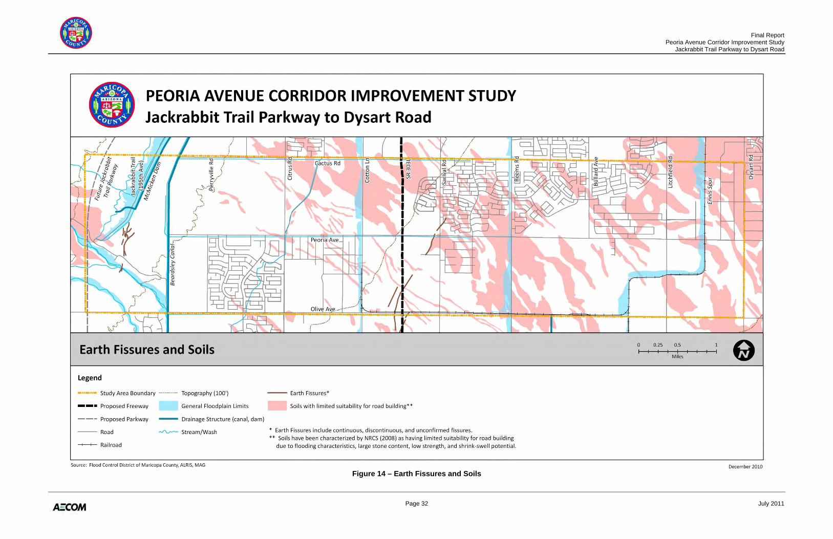
2.5.1 Section 4(f) Resources Section 4(f) of the Department of Transportation Act of 1966 (49 USC 303) prohibits the use of land of significant publicly owned parks, recreation areas, wildlife and waterfowl refuges, and land of a historic site for transportation projects unless the Federal Highway Administration (FHWA) determines that there is no feasible and prudent avoidance alternative and that all possible planning to minimize harm has occurred. While there are no city or county parks within the study area (White Tank Mountain Regional Park is located just west of the study area), there are several community or “pocket” parks within developed communities. School playgrounds may qualify as Section 4(f) resources if they are publicly owned, open to the public, have a major recreational purpose, and are considered by the community to be a significant resource. For instance, Shadow Ridge High School is located immediately adjacent to Peoria Avenue in the western limits of the study area. There are several other schools within the study limits, though not immediately adjacent to Peoria Avenue: Mountain View Elementary, Sonoran Heights Elementary, Rancho Gabriela Elementary, and Imagine Middle School. Some historic sites on or eligible for the National Register of Historic Places (NRHP) may also be afforded protection by Section 4(f). However, there are currently limited amounts of information available regarding historic properties within the study area. Of the known sites, the Beardsley Canal and the BNSF Ennis Spur could potentially be afforded protection under Section 4(f). 2.5.2 Soils and Earth Fissures As shown in Figure 14, there are areas of soils with high shrink-swell potential located on both the western and eastern boundaries of the study area. These soils are one of several soil units present throughout the study area that are rated as having “limited suitability for road building” by the Natural Resources Conservation Service (NRCS), due to flooding characteristics, large stone content, low strength, and shrink-swell potential. Fissures are cracks in the ground surface that occur due to uneven land subsidence and can form gullies as much as 50 feet wide and 10 to 15 feet deep. Existing and potential locations of earth fissures have been mapped south of McMicken Dam, at SR 303L near Olive Avenue, and at Peoria Avenue near Sarival Road (Figure 14). The effects of earth fissures can be significant, causing damage to infrastructure, increasing flood potential, worsening groundwater pollution, and accelerating soil erosion. Continued land subsidence and accompanying earth fissures will likely occur in this area as long as groundwater overdraft continues. 2.5.3 Wildlife and Wildlife Movement Maintaining access between large habitat blocks, such as the White Tank Mountain Regional Park located just west of the study area, and natural corridors in the landscape, such as the
Final Report Peoria Avenue Corridor Improvement Study Jackrabbit Trail Parkway to Dysart Road
Page 10 July 2011
Agua Fria River which is located just east of the study area, is key to maintaining native biodiversity as much as possible in the metropolitan area. The Peoria Avenue Corridor could provide such a connection if low-cost wildlife connectivity features are considered during the design process. Guidelines for facilitating wildlife connectivity have been developed by the Arizona Wildlife Linkages Workgroup, the Arizona Game and Fish Department (AGFD), and Arizona Missing Linkages organization. The relatively undisturbed desert land in the western portion offers potential habitat for many desert wildlife species of all sizes. The proximity and connectivity to the White Tank Mountain Regional Park likely allows use of the area by larger animals than would often be found in land adjacent to urban areas. A significant portion of the more urbanized study area has long been developed for agricultural uses and offer some nesting and foraging habitat for birds, small rodents, and other small mammals. As residential and commercial uses develop, a variety of wildlife species adapted to urban conditions will continue to use vegetation in residential and commercial landscaping, parks, and remaining agricultural fields. 2.5.4 Hazardous Materials A regulatory database search for hazardous materials was conducted for the study area. A review of the records search identified six registered underground storage tanks (USTs), two leaking USTs, previous chemical spills and illegal dumping, over 400 drywells, and 94 groundwater wells. Many groundwater wells and drywells within the study area may be impacted, depending on the chosen alignment. Further investigation of hazardous materials issues is recommended in subsequent studies and design. Once the construction area has been established, additional research and visual inspection should be performed to evaluate the potential presence of groundwater wells, dry wells, and/or surface contamination within the construction zone. Prior to project construction activities, performing a Phase I/II site assessment on the property acquired for the project would provide information necessary to determine environmental conditions and reduce exposure from hazardous materials contamination. 2.5.5 Cultural Resources To identify potential cultural resources, sources examined include files at the State Historic Preservation Office (SHPO) and the AZSITE electronic database. Records reviewed show that the study area consists of approximately 24 cultural resource inventories undertaken from 1987 to 2004. Inventory levels range from unsurveyed to completely surveyed, with the majority of sections only partially surveyed. Not all archaeological inventories conducted may appear on AZSITE if they were undertaken on private land, as private land owners are not required to report inventories to public officials. The existing cultural resource inventories identify 22 sites within the study area. The majority of NRHP-eligible sites and those requiring testing are located west of the proposed SR 303L.
Final Report Peoria Avenue Corridor Improvement Study Jackrabbit Trail Parkway to Dysart Road
Page 11 July 2011
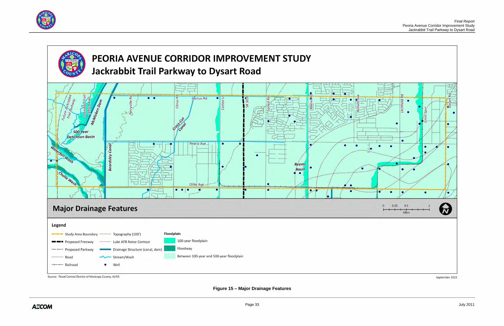
While numerous sections of the historic Beardsley Canal are considered eligible, the section within the study area has not been evaluated. The BNSF Railway has been determined eligible, however the BNSF Ennis Spur has not been evaluated for NRHP eligibility. There are no records of historic property inventories within the study area. However, a preliminary field review observed residences and structures present on the parcels adjacent to Peoria Avenue that could potentially be 50 years old or older. Typically, historic properties are at least 50 years old, but younger properties may be considered for listing if they are of exceptional importance. Should project design include any of these parcels, the structure(s) may need to be evaluated for their eligibility for inclusion in the NRHP. 2.6 DRAINAGE SUMMARY Technical Memorandum No. 3: Drainage Overview documents the full overview of existing drainage conditions within the study area (Appendix C). Figure 15 summarizes these conditions and depicts the major drainage features for the Peoria Avenue study area. Major drainage structures include:
• McMicken Dam: The dam is almost eleven miles long, following an alignment offset from the Beardsley Canal, beginning at Peoria Avenue west of Perryville Road and extending north and east to Happy Valley Road west of Bullard Avenue. The dam is operated and maintained by the FCDMC. The dam detains storm runoff and meters outflows through a channel located at the east end of the structure. The Peoria Avenue section line intersects the detention basin located immediately south of the dam.
• Canals: The Beardsley Canal is located approximately a half mile west of Perryville Road and is owned by the MWD. A series of irrigation canals/ditches are also owned by the MWD in the study area. These east-west canals connect with the Beardsley Canal on the west end, extending to approximately one-half mile east of Sarival Road, located south of Peoria Avenue and south of Cactus Road. Parallel, but privately owned, irrigation canals also exist in segments along the south side of Peoria Avenue. Additionally, MWD manages the Cross-Cut Canal and Pipeline, which crosses Peoria Avenue underground, along Citrus Avenue.
• Reems Road Channel and Basin: This structure is a regional flood control facility to
intercept and convey the 100-year stormwater event. The ultimate facility includes a channel flowing south along Reems Road from Bell Road to the Reems Basin, an off-line detention basin is located a quarter-mile south of Peoria Avenue. The purpose of the channel is to protect Reems Road and the land to the east, including the City of Surprise wastewater treatment plant and various utilities.
While no rivers are located within the study area, several streams and washes traverse the area, generally located in the westernmost portion, draining from the White Tank Mountains.
Final Report Peoria Avenue Corridor Improvement Study Jackrabbit Trail Parkway to Dysart Road
Page 12 July 2011
Federal Emergency Management Agency (FEMA) maps show most of the study area to be within the 100-year to 500-year floodplain. Concentrations of land are located within the 100-year floodplain, including drainage areas west of McMicken Dam, major washes, and the channels west of Cotton Lane, Reems Road, and the BNSF Ennis Spur. The 100-year floodplains adjacent to major roadways serve as permanent drainage channels, with the land owned and controlled by the FCDMC, and therefore preserved against future development. As uncontrolled or natural drainage features, both Waterfall and Cholla Washes include floodway areas. A number of wells exist in the study area, including several located adjacent to Peoria Avenue, whose locations will need to be considered with respect to potential roadway improvements. A series of channels and basins are in varying stages of development throughout the corridor, including public channels and basins being implemented by the FCDMC, as well as a series of private channels and basins, such as at Shadow Ridge High School and within the master planned communities of Greer Ranch, Twelve Oaks Estates, and Copper Canyon Ranch (Mountain Gate). The following summarizes major drainage issues considered in the development of alternatives and selection of the preferred alternative:
• Under current conditions, roadways within the study area are exposed to flooding as berms and irrigation facilities preclude off-site runoff from sheet flowing onto agricultural fields. As land use changes and urbanization expands, less off-site runoff is expected to reach the roadway grid.
• The completion of recommended FCDMC capital improvement projects will significantly reduce the amount of flow that runs along Peoria Avenue, making existing and planned developer-built roadside channels sufficient to contain off-site flows. The intersection of Litchfield Road and Peoria Avenue is of special concern, as the anticipated outfall channel to the south may take a while to be completed.
• The corridor should include a system of roadside channels and culverts to accept combined off-site and on-site flows. The proposed channels along SR 303L, Reems Road, and the BNSF Ennis Spur have sufficient capacity to accept flows from the Peoria Avenue system. Closed storm drain systems that connect to roadside channels can be used in areas where right-of-way availability is limited.
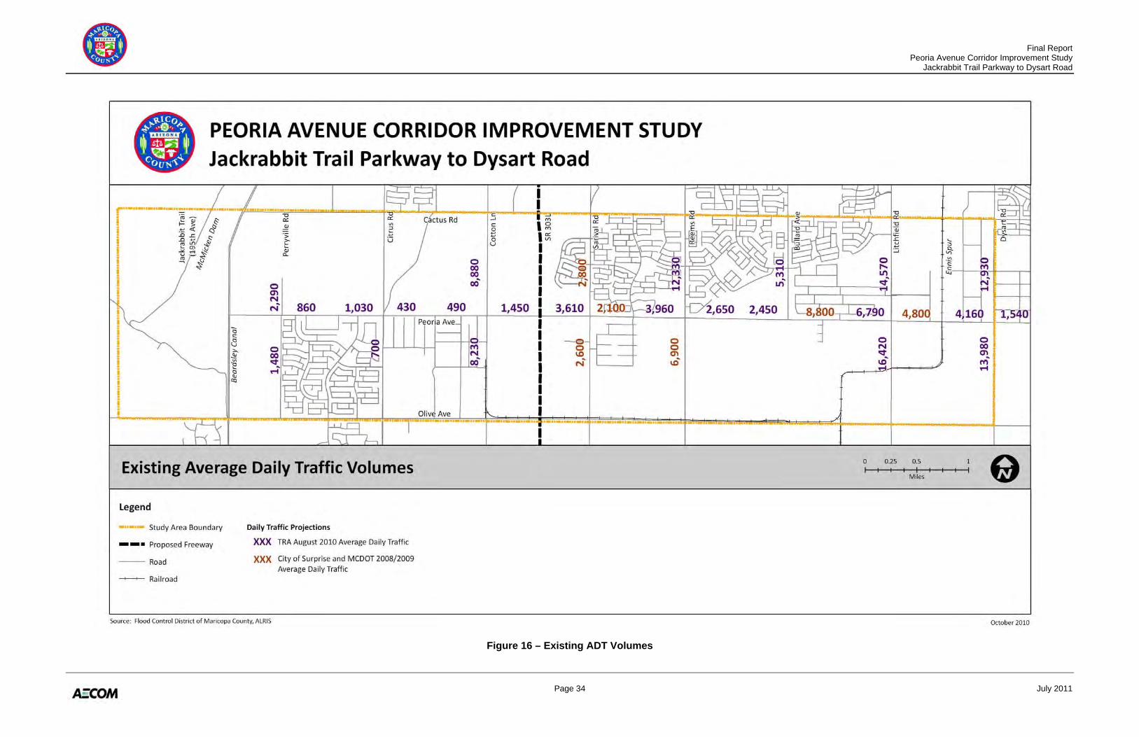
2.7 TRAFFIC SUMMARY Technical Memorandum No. 7: Traffic Analysis documents the full analysis of existing and future traffic conditions within the study area (Appendix G). A summary of the analysis follows. 2.7.1 Existing Traffic Volumes Historical traffic volumes were obtained from the City of Surprise and MCDOT for years 2008–2009 where available. In addition, Traffic Research & Analysis, Inc. (TRA) conducted traffic
Final Report Peoria Avenue Corridor Improvement Study Jackrabbit Trail Parkway to Dysart Road
Page 13 July 2011
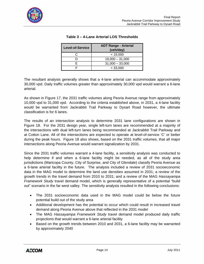
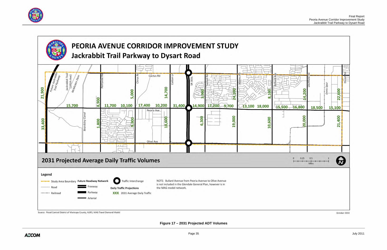
counts in August 2010 at several locations in the study area. The existing average daily traffic (ADT) volumes within the study area are shown in Figure 16. Existing ADT on Peoria Avenue varies from approximately 900 vehicles per day (vpd) at the west end to 9,000 vpd between Bullard Avenue and Litchfield Road. A majority of the north/south arterial cross streets along the corridor currently carry more traffic than Peoria Avenue itself. With the exception of SR 303L, Litchfield Road has the highest existing cross street daily traffic volume (16,500 to 14,600 vpd) in the study area. Classification counts were also conducted at three locations within the study area: (1) Peoria Avenue east of Cotton Lane; (2) Cotton Lane north of Peoria Avenue; and (3) Litchfield Road north of Peoria Avenue. All three locations show that passenger cars comprise a vast majority of the existing daily traffic volumes (approximately 98 percent) while large trucks comprise less than 1 percent of the daily traffic volumes. The remaining 1 to 2 percent is medium-sized vehicles (e.g., buses, RVs, small trucks). 2.7.2 Future Traffic Volumes MAG provided design year 2031 traffic volume projections for use in this study. MAG network simulations were provided for the 2031 design year. For the purposes of the MAG model, the network includes three traffic lanes in each direction of travel on Peoria Avenue. The 2031 traffic volume projections are shown in Figure 17. MCDOT does not include a Peoria Avenue crossing of the Agua Fria River in its current or future roadway network. Other regional planning studies have suggested a need for a river crossing and the City of El Mirage has included a crossing in its planned roadway network. While this river crossing may not be implemented in the near future, a conservative approach (by including the river crossing) was used to project the 2031 Peoria Avenue travel demand. While the transportation plans described in Section 2.2 were used to establish the ultimate Peoria Avenue classification, the 2031 travel demand analysis was used to help determine an implementation strategy for the corridor. 2.7.3 Traffic Analysis and Results Table 2.1 of the MCDOT Roadway Design Manual includes information regarding planning level traffic volume thresholds for different facility types. According to this table, a 4-lane urban arterial can accommodate approximately 35,000 vpd. In addition, planning level analyses were conducted using Highway Capacity Software to estimate volume thresholds for a 4-lane urban arterial roadway. Based on these analyses, Table 3 shows the resulting daily traffic ranges and corresponding level-of-service thresholds.
Final Report Peoria Avenue Corridor Improvement Study Jackrabbit Trail Parkway to Dysart Road
Page 14 July 2011
Table 3 – 4-Lane Arterial LOS Thresholds
Level-of-Service ADT Range - Arterial (veh/day)
C < 19,000 D 19,000 – 31,000 E 31,000 – 33,000 F > 33,000
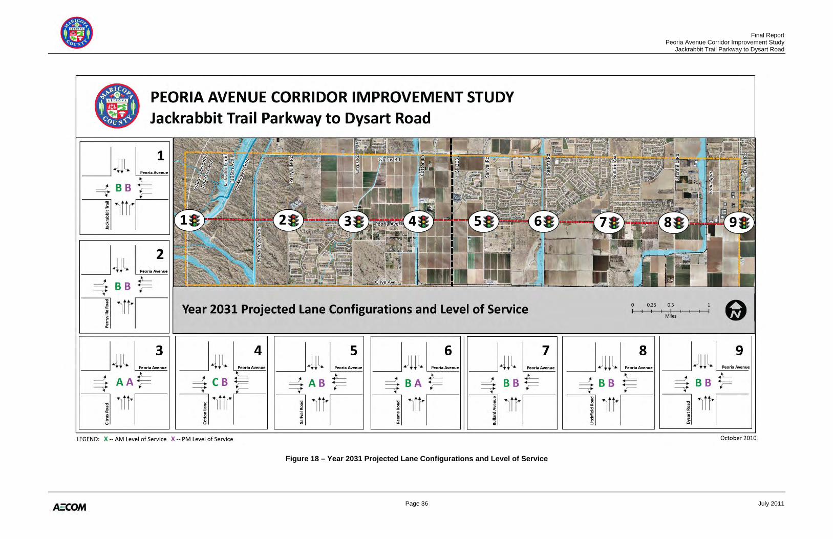
The resultant analysis generally shows that a 4-lane arterial can accommodate approximately 30,000 vpd. Daily traffic volumes greater than approximately 30,000 vpd would warrant a 6-lane arterial. As shown in Figure 17, the 2031 traffic volumes along Peoria Avenue range from approximately 10,000 vpd to 31,000 vpd. According to the criteria established above, in 2031, a 4-lane facility would be warranted from Jackrabbit Trail Parkway to Dysart Road however, the ultimate classification is for 6 lanes. The results of an intersection analysis to determine 2031 lane configurations are shown in Figure 18. For the 2031 design year, single left-turn lanes are recommended at a majority of the intersections with dual left-turn lanes being recommended at Jackrabbit Trail Parkway and at Cotton Lane. All of the intersections are expected to operate at level-of-service ‘C’ or better during the peak hours. Figure 18 also shows, based on the 2031 traffic volumes, that all major intersections along Peoria Avenue would warrant signalization by 2031. Since the 2031 traffic volumes warrant a 4-lane facility, a sensitivity analysis was conducted to help determine if and when a 6-lane facility might be needed, as all of the study area jurisdictions (Maricopa County, City of Surprise, and City of Glendale) classify Peoria Avenue as a 6-lane arterial facility in the future. The analysis included a review of 2031 socioeconomic data in the MAG model to determine the land use densities assumed in 2031; a review of the growth trends in the travel demand from 2010 to 2031; and a review of the MAG Hassayampa Framework Study travel demand model, which is generally representative of a potential “build out” scenario in the far west valley. The sensitivity analysis resulted in the following conclusions:
• The 2031 socioeconomic data used in the MAG model could be below the future potential build out of the study area
• Additional development has the potential to occur which could result in increased travel demand along Peoria Avenue above that reflected in the 2031 model
• The MAG Hassayampa Framework Study travel demand model produced daily traffic projections that would warrant a 6-lane arterial facility
• Based on the growth trends between 2010 and 2031, a 6-lane facility may be warranted by approximately 2040
Final Report Peoria Avenue Corridor Improvement Study Jackrabbit Trail Parkway to Dysart Road
Page 15 July 2011
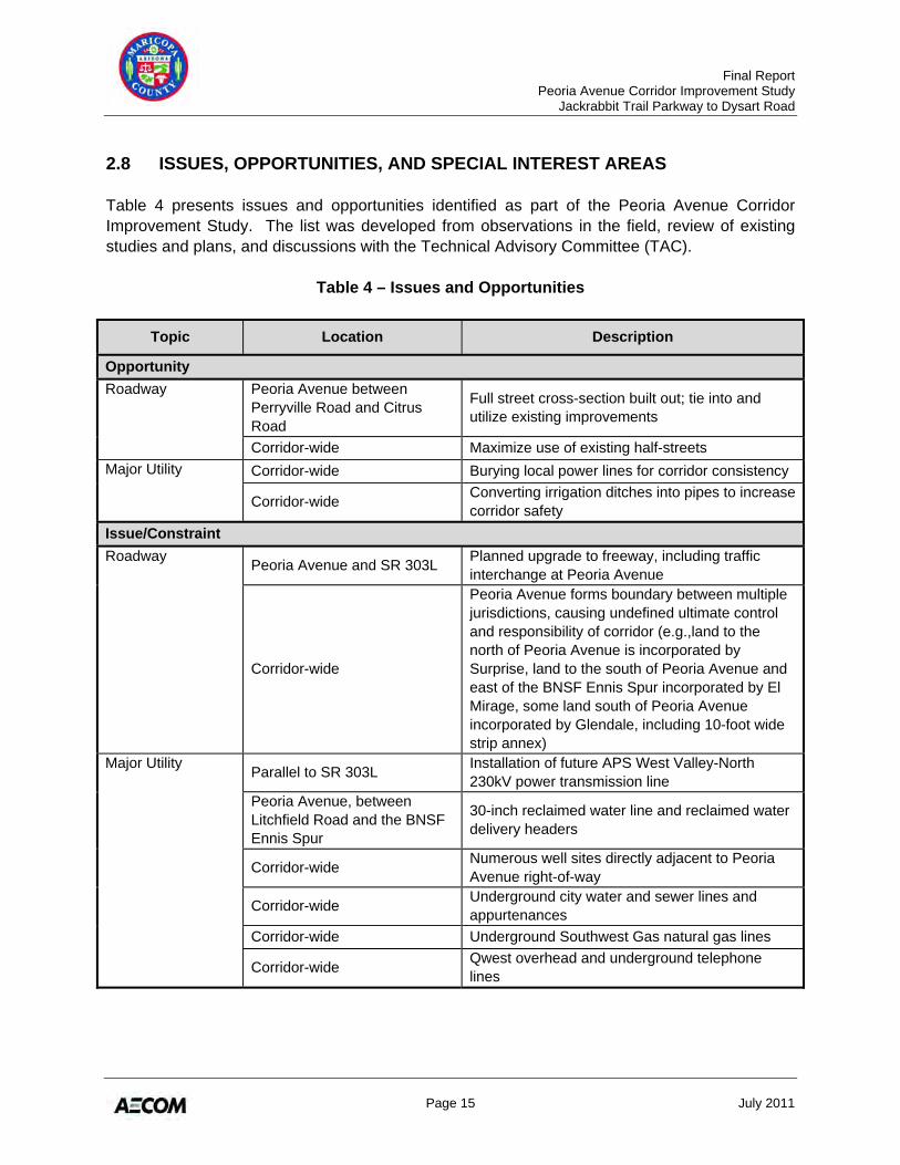
2.8 ISSUES, OPPORTUNITIES, AND SPECIAL INTEREST AREAS Table 4 presents issues and opportunities identified as part of the Peoria Avenue Corridor Improvement Study. The list was developed from observations in the field, review of existing studies and plans, and discussions with the Technical Advisory Committee (TAC).
Table 4 – Issues and Opportunities
Topic Location Description
Opportunity Roadway Peoria Avenue between
Perryville Road and Citrus Road
Full street cross-section built out; tie into and utilize existing improvements
Corridor-wide Maximize use of existing half-streets Major Utility Corridor-wide Burying local power lines for corridor consistency
Corridor-wide Converting irrigation ditches into pipes to increase corridor safety
Issue/Constraint Roadway Peoria Avenue and SR 303L Planned upgrade to freeway, including traffic
interchange at Peoria Avenue
Corridor-wide
Peoria Avenue forms boundary between multiple jurisdictions, causing undefined ultimate control and responsibility of corridor (e.g.,land to the north of Peoria Avenue is incorporated by Surprise, land to the south of Peoria Avenue and east of the BNSF Ennis Spur incorporated by El Mirage, some land south of Peoria Avenue incorporated by Glendale, including 10-foot wide strip annex)
Major Utility Parallel to SR 303L Installation of future APS West Valley-North 230kV power transmission line
Peoria Avenue, between Litchfield Road and the BNSF Ennis Spur
30-inch reclaimed water line and reclaimed water delivery headers
Corridor-wide Numerous well sites directly adjacent to Peoria Avenue right-of-way
Corridor-wide Underground city water and sewer lines and appurtenances
Corridor-wide Underground Southwest Gas natural gas lines
Corridor-wide Qwest overhead and underground telephone lines
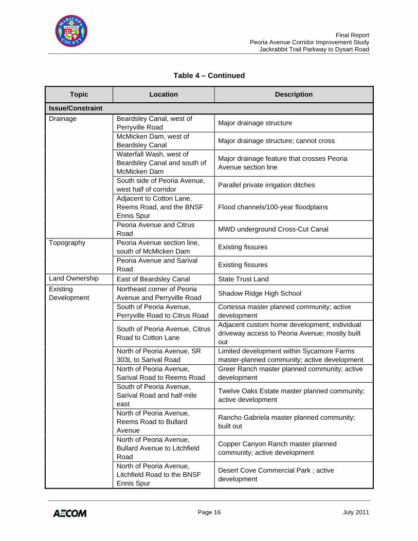
Final Report Peoria Avenue Corridor Improvement Study Jackrabbit Trail Parkway to Dysart Road
Page 16 July 2011
Table 4 – Continued
Topic Location Description
Issue/Constraint Drainage Beardsley Canal, west of
Perryville Road Major drainage structure
McMicken Dam, west of Beardsley Canal Major drainage structure; cannot cross
Waterfall Wash, west of Beardsley Canal and south of McMicken Dam
Major drainage feature that crosses Peoria Avenue section line
South side of Peoria Avenue, west half of corridor Parallel private irrigation ditches
Adjacent to Cotton Lane, Reems Road, and the BNSF Ennis Spur
Flood channels/100-year floodplains
Peoria Avenue and Citrus Road MWD underground Cross-Cut Canal
Topography Peoria Avenue section line, south of McMicken Dam Existing fissures
Peoria Avenue and Sarival Road Existing fissures
Land Ownership East of Beardsley Canal State Trust Land Existing Development
Northeast corner of Peoria Avenue and Perryville Road Shadow Ridge High School
South of Peoria Avenue, Perryville Road to Citrus Road
Cortessa master planned community; active development
South of Peoria Avenue, Citrus Road to Cotton Lane
Adjacent custom home development; individual driveway access to Peoria Avenue; mostly built out
North of Peoria Avenue, SR 303L to Sarival Road
Limited development within Sycamore Farms master-planned community; active development
North of Peoria Avenue, Sarival Road to Reems Road
Greer Ranch master planned community; active development
South of Peoria Avenue, Sarival Road and half-mile east
Twelve Oaks Estate master planned community; active development
North of Peoria Avenue, Reems Road to Bullard Avenue
Rancho Gabriela master planned community; built out
North of Peoria Avenue, Bullard Avenue to Litchfield Road
Copper Canyon Ranch master planned community; active development
North of Peoria Avenue, Litchfield Road to the BNSF Ennis Spur
Desert Cove Commercial Park ; active development
Final Report Peoria Avenue Corridor Improvement Study Jackrabbit Trail Parkway to Dysart Road
Page 17 July 2011
Table 4 – Continued
Topic Location Description
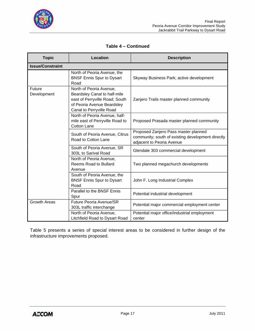
Issue/Constraint North of Peoria Avenue, the
BNSF Ennis Spur to Dysart Road
Skyway Business Park; active development
Future Development
North of Peoria Avenue, Beardsley Canal to half-mile east of Perryville Road; South of Peoria Avenue Beardsley Canal to Perryville Road
Zanjero Trails master planned community
North of Peoria Avenue, half-mile east of Perryville Road to Cotton Lane
Proposed Prasada master planned community
South of Peoria Avenue, Citrus Road to Cotton Lane
Proposed Zanjero Pass master planned community; south of existing development directly adjacent to Peoria Avenue
South of Peoria Avenue, SR 303L to Sarival Road Glendale 303 commercial development
North of Peoria Avenue, Reems Road to Bullard Avenue
Two planned megachurch developments
South of Peoria Avenue, the BNSF Ennis Spur to Dysart Road
John F. Long Industrial Complex
Parallel to the BNSF Ennis Spur Potential industrial development
Growth Areas Future Peoria Avenue/SR 303L traffic interchange Potential major commercial employment center
North of Peoria Avenue, Litchfield Road to Dysart Road
Potential major office/industrial employment center
Table 5 presents a series of special interest areas to be considered in further design of the infrastructure improvements proposed.
Final Report Peoria Avenue Corridor Improvement Study Jackrabbit Trail Parkway to Dysart Road
Page 18 July 2011
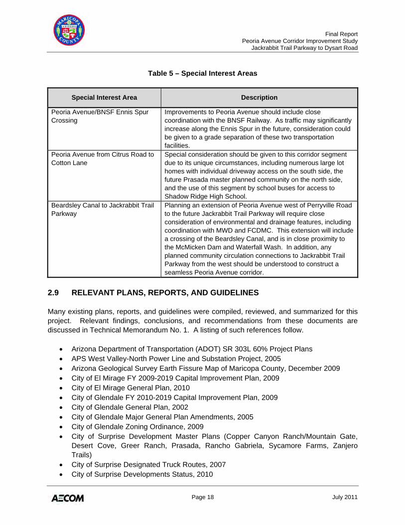
Table 5 – Special Interest Areas
Special Interest Area Description
Peoria Avenue/BNSF Ennis Spur Crossing
Improvements to Peoria Avenue should include close coordination with the BNSF Railway. As traffic may significantly increase along the Ennis Spur in the future, consideration could be given to a grade separation of these two transportation facilities.
Peoria Avenue from Citrus Road to Cotton Lane
Special consideration should be given to this corridor segment due to its unique circumstances, including numerous large lot homes with individual driveway access on the south side, the future Prasada master planned community on the north side, and the use of this segment by school buses for access to Shadow Ridge High School.
Beardsley Canal to Jackrabbit Trail Parkway
Planning an extension of Peoria Avenue west of Perryville Road to the future Jackrabbit Trail Parkway will require close consideration of environmental and drainage features, including coordination with MWD and FCDMC. This extension will include a crossing of the Beardsley Canal, and is in close proximity to the McMicken Dam and Waterfall Wash. In addition, any planned community circulation connections to Jackrabbit Trail Parkway from the west should be understood to construct a seamless Peoria Avenue corridor.
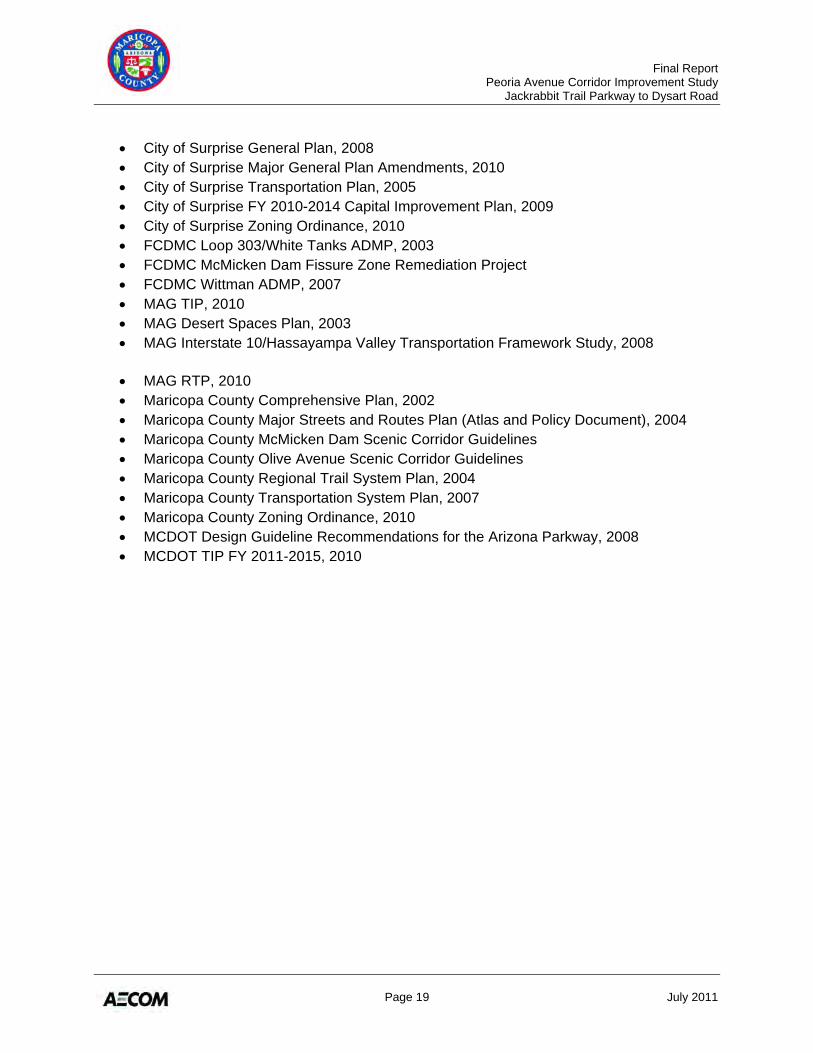
2.9 RELEVANT PLANS, REPORTS, AND GUIDELINES Many existing plans, reports, and guidelines were compiled, reviewed, and summarized for this project. Relevant findings, conclusions, and recommendations from these documents are discussed in Technical Memorandum No. 1. A listing of such references follow.
• Arizona Department of Transportation (ADOT) SR 303L 60% Project Plans • APS West Valley-North Power Line and Substation Project, 2005 • Arizona Geological Survey Earth Fissure Map of Maricopa County, December 2009 • City of El Mirage FY 2009-2019 Capital Improvement Plan, 2009 • City of El Mirage General Plan, 2010 • City of Glendale FY 2010-2019 Capital Improvement Plan, 2009 • City of Glendale General Plan, 2002 • City of Glendale Major General Plan Amendments, 2005 • City of Glendale Zoning Ordinance, 2009 • City of Surprise Development Master Plans (Copper Canyon Ranch/Mountain Gate,
Desert Cove, Greer Ranch, Prasada, Rancho Gabriela, Sycamore Farms, Zanjero Trails)
• City of Surprise Designated Truck Routes, 2007 • City of Surprise Developments Status, 2010
Final Report Peoria Avenue Corridor Improvement Study Jackrabbit Trail Parkway to Dysart Road
Page 19 July 2011
• City of Surprise General Plan, 2008 • City of Surprise Major General Plan Amendments, 2010 • City of Surprise Transportation Plan, 2005 • City of Surprise FY 2010-2014 Capital Improvement Plan, 2009 • City of Surprise Zoning Ordinance, 2010 • FCDMC Loop 303/White Tanks ADMP, 2003 • FCDMC McMicken Dam Fissure Zone Remediation Project • FCDMC Wittman ADMP, 2007 • MAG TIP, 2010 • MAG Desert Spaces Plan, 2003 • MAG Interstate 10/Hassayampa Valley Transportation Framework Study, 2008
• MAG RTP, 2010 • Maricopa County Comprehensive Plan, 2002 • Maricopa County Major Streets and Routes Plan (Atlas and Policy Document), 2004 • Maricopa County McMicken Dam Scenic Corridor Guidelines • Maricopa County Olive Avenue Scenic Corridor Guidelines • Maricopa County Regional Trail System Plan, 2004 • Maricopa County Transportation System Plan, 2007 • Maricopa County Zoning Ordinance, 2010 • MCDOT Design Guideline Recommendations for the Arizona Parkway, 2008 • MCDOT TIP FY 2011-2015, 2010

Final Report Peoria Avenue Corridor Improvement Study Jackrabbit Trail Parkway to Dysart Road
Page 20 July 2011
Figure 2 – Existing Transportation Network
Final Report Peoria Avenue Corridor Improvement Study Jackrabbit Trail Parkway to Dysart Road
Page 21 July 2011
Figure 3 – Existing Roadway Alignment
Final Report Peoria Avenue Corridor Improvement Study Jackrabbit Trail Parkway to Dysart Road
Page 22 July 2011
Figure 4 – Existing Right-of-Way Widths
Final Report Peoria Avenue Corridor Improvement Study Jackrabbit Trail Parkway to Dysart Road
Page 23 July 2011
Figure 5 – Existing Access Conditions (Sheet 1)
Final Report Peoria Avenue Corridor Improvement Study Jackrabbit Trail Parkway to Dysart Road
Page 24 July 2011
Figure 6 – Existing Access Conditions (Sheet 2)
Final Report Peoria Avenue Corridor Improvement Study Jackrabbit Trail Parkway to Dysart Road
Page 25 July 2011
Figure 7 – Future Multimodal Transportation Network
Final Report Peoria Avenue Corridor Improvement Study Jackrabbit Trail Parkway to Dysart Road
Page 26 July 2011
Figure 8 – Utilities
Final Report Peoria Avenue Corridor Improvement Study Jackrabbit Trail Parkway to Dysart Road
Page 27 July 2011
Figure 9 – Land Ownership
Final Report Peoria Avenue Corridor Improvement Study Jackrabbit Trail Parkway to Dysart Road
Page 28 July 2011
Figure 10 – Municipal Planning Areas and Incorporated Areas
Final Report Peoria Avenue Corridor Improvement Study Jackrabbit Trail Parkway to Dysart Road
Page 29 July 2011
Figure 11 – Existing Land Use
Final Report Peoria Avenue Corridor Improvement Study Jackrabbit Trail Parkway to Dysart Road
Page 30 July 2011
Figure 12 – Future Land Use
Final Report Peoria Avenue Corridor Improvement Study Jackrabbit Trail Parkway to Dysart Road
Page 31 July 2011
Figure 13 – Master Planned Communities
Final Report Peoria Avenue Corridor Improvement Study Jackrabbit Trail Parkway to Dysart Road
Page 32 July 2011
Figure 14 – Earth Fissures and Soils
Final Report Peoria Avenue Corridor Improvement Study Jackrabbit Trail Parkway to Dysart Road
Page 33 July 2011
Figure 15 – Major Drainage Features
Final Report Peoria Avenue Corridor Improvement Study Jackrabbit Trail Parkway to Dysart Road
Page 34 July 2011
Figure 16 – Existing ADT Volumes
Final Report Peoria Avenue Corridor Improvement Study Jackrabbit Trail Parkway to Dysart Road
Page 35 July 2011
Figure 17 – 2031 Projected ADT Volumes
Final Report Peoria Avenue Corridor Improvement Study Jackrabbit Trail Parkway to Dysart Road
Page 36 July 2011
Figure 18 – Year 2031 Projected Lane Configurations and Level of Service
Final Report Peoria Avenue Corridor Improvement Study Jackrabbit Trail Parkway to Dysart Road
Page 37 July 2011
3.0 DEVELOPMENT AND EVALUATION OF ALTERNATIVE ALIGNMENTS
Technical Memorandum No. 4: Candidate Alternative Alignments and Evaluation documents the alternatives development and evaluation process used for this project. The full technical memorandum is located in Appendix D. After completion of the inventory of existing conditions and traffic forecasts, the study team conducted a single-tiered process of developing and evaluating alternatives, including the following major steps:
• Development of evaluation criteria and performance measures upon which candidate alternatives would be evaluated
• Development of candidate alternatives • Evaluation of candidate alternatives, with input from the TAC and general public • Determination of recommended alternative
3.1 EVALUATION CRITERIA
Table 6 lists the evaluation criteria, a short description, and performance measures associated with each. The number of performance measures varies for each criterion, reflecting the inherent complexity and amount of data available for each element. The performance measures are intended to minimize or maximize an outcome that reflects fulfillment of the criterion. Some of the measures are evaluated numerically; others are based on a qualitative assessment.
Table 6 – Evaluation Criteria and Performance Measures
Criteria Title Criteria Description Criteria Performance Measure
Right-of-Way Considerations
An assessment of the amount and value of the right-of-way that would need to be acquired for corridor alternatives in relation to other alternatives under consideration for the segment.
Quantitative assessment of acres or square feet of acquisition Qualitative assessment of potential cost
Compatibility with Existing Developments
An estimate of the potential effect of proposed corridor alternatives on the existing developments most directly affected. Key considerations include the proximity to existing developments and potential displacements.
Qualitative assessment of compatibility
Final Report Peoria Avenue Corridor Improvement Study Jackrabbit Trail Parkway to Dysart Road
Page 38 July 2011
Table 6 –Continued
Criteria Title Criteria Description Criteria Performance Measure
Compatibility with Planned Future Developments
An estimate of the potential effect of the corridor alternatives on planned developments and/or land that is currently under the jurisdiction of the Arizona State Land Department. Key considerations include compatibility with approved master plans and/or preliminary and final plats.
Qualitative assessment of compatibility
Compatibility with Existing and Planned Roadway Improvements
An assessment of the compatibility of the corridor alternatives with the existing and planned roadway improvements.
Qualitative assessment of compatibility
Engineering Complexity and Constructability
A general assessment of engineering complications, exclusive of cost considerations, which could arise from construction of the roadway. Key considerations include roadway geometry, permitting requirements, construction staging, etc.
Qualitative assessment of complexity and constructability
Public Acceptability
Estimated community support for and acceptance of the corridor alternative, based on input from municipal staff, stakeholders, homeowner associations, and the public.
Qualitative assessment of acceptability
Local Agency Support Estimated local agency (city) support for and acceptance of the corridor alternative, based on input from municipal staff.
Qualitative assessment of acceptability
Drainage/Flood Control Considerations
An estimate of potential impacts from the proposed corridor alternatives to both existing FCDMC facilities as well as to future improvements.
Qualitative assessment of potential impacts
Environmental Considerations
An assessment of social, ecological, and cultural environment in the study area.
Qualitative assessment of potential impacts to socioeconomic environmentQualitative assessment of potential impacts to physical and natural environment Qualitative assessment of potential impacts to cultural resources
Utility Considerations
Estimate of potential impacts from the proposed corridor alternative to both existing and planned future utility facilities such as the MWD canals, wells, reclaimed water delivery headers, and overhead lines.
Quantitative assessment of potential impacts
Source: Project Team, October 2010
Final Report Peoria Avenue Corridor Improvement Study Jackrabbit Trail Parkway to Dysart Road
Page 39 July 2011
3.2 CANDIDATE ALTERNATIVES AND EVALUATION
A series of three alternative alignments were considered for Peoria Avenue. For planning purposes, a 140-foot wide (minimum) corridor was used for each alternative. Alternative 1 includes widening the corridor symmetric about the section line. Alternative 2 includes widening the corridor to the south, maintaining the northern right-of-way (R/W) boundary. Alternative 3 includes widening the corridor to the north, maintaining the southern R/W boundary. Because the existing R/W throughout the corridor differs due to varying dedications of land, the degree of shifting to the north or south changes. For example, in some areas a shift may represent a difference of only five feet; in others, a shift could represent a change of 55 feet. To help in the analysis, the Peoria Avenue corridor was divided into nine segments for the evaluation process (delineated in the table below). Table 7 describes the alignment of each alternative within each segment. Because Peoria Avenue does not yet exist through Segments 1 and 2, and because of other constraints, fewer alternatives were considered for these segments than elsewhere. The full technical memorandum, located in Appendix D, contains plan sheets showing the various alternatives.
Table 7 – Alternative Alignment Descriptions
Segment Alternative Alternative Description Additional Information
Segment 1: Future Jackrabbit Trail Parkway to Beardsley Canal
1 Centered on section line Goes through basin and floodpool
2 South of reconstructed McMicken Dam Goes south of floodpool
Segment 2: Beardsley Canal to Perryville Road
1 Centered on section line Matches Zanjero Trails Preliminary Plat
Segment 3: Perryville Road to Citrus Road
1 Centered on section line 140-foot wide corridor requires acquisition on both sides
2 Centerline shifted 5 feet south of section line
Holds planned dedicated R/W along north side
3 Centerline shifted 15 feet north of section line Holds existing south R/W line
Segment 4: Citrus Road to Cotton Lane
1 Centered on section line 140-foot wide corridor requires acquisition on both sides
2 Centerline shifted 5 feet south of section line
Holds planned dedicated R/W along north side
3 Centerline shifted 37 feet north of section line
Places south R/W line approximately 10 feet south of irrigation ditch and allows room for potential frontage road
Final Report Peoria Avenue Corridor Improvement Study Jackrabbit Trail Parkway to Dysart Road
Page 40 July 2011
Table 7 – Continued
Segment Alternative Alternative Description Additional Information
Segment 5: Cotton Lane to Sarival Road 1 Centered on section line
176-foot wide corridor requires acquisition on both sides; wider corridor adjacent to SR 303L/Peoria Avenue traffic interchange
2 Centerline shifted 55 feet south of section line Holds existing north R/W line
3 Centerline shifted 55 feet north of section line Holds existing south R/W line
Segment 6: Sarival Road to Reems Road
1 Centered on section line 140-foot wide corridor requires acquisition on both sides
2 Centerline shifted 15 feet south of section line
Holds existing R/W line along developed areas
3 Centerline shifted 5 feet north of section line
Holds existing R/W line along developed areas
Segment 7: Reems Road to Bullard Avenue
1 Centered on section line 140-foot wide corridor requires acquisition on both sides
2 Centerline shifted 5 feet south of section line
Holds existing R/W line along developed areas
3 Centerline shifted 30 feet north of section line Holds existing south R/W line
Segment 8: Bullard Avenue to Litchfield Road
1 Centered on section line 140-foot wide corridor requires acquisition on both sides
2 Centerline shifted 15 feet south of section line Holds existing north R/W line
3 Centerline shifted 30 feet north of section line Holds existing south R/W line
Segment 9: Litchfield Road to Dysart Road
1 Centered on section line 140-foot wide corridor requires acquisition on both sides
2
Centerline shifted south of section line (varies from 2 feet [west end], to 37 feet [middle], to 2 feet [east end])
Holds existing north R/W line
3
Centerline shifted north of section line (varies from 30 feet [east end] to 37 feet [west end])
Holds existing south R/W line
Source: Project Team, November 2010

Final Report Peoria Avenue Corridor Improvement Study Jackrabbit Trail Parkway to Dysart Road
Page 41 July 2011
3.3 ALTERNATIVES EVALUATION
Each alternative was evaluated with respect to each segment, and each segment was evaluated independently of the others. The full results of the evaluation can be found in Tables 3 through 10 of Technical Memorandum No. 4, located in Appendix D. The evaluation was conducted by a multidisciplinary consultant team, with input from various sources, including the TAC during December 2010 and January 2011, as well as the public at an open house meeting held in January 2011. 3.3.1 Results and Recommendations Through the evaluation process, some segments (2, 4, 6 and 8) contained constraints and/or opportunities that clearly favored one alternative. Once their alignment recommendations were established, these segments assisted in determining the preferred alternative for the adjacent segments (3, 5, 7 and 9). To show this process, the following evaluation highlights are presented out of numerical order. Segment 2: Beardsley Canal to Perryville Road The Zanjero Trails master planned community is planned on both sides of Peoria Avenue between the Beardsley Canal and Perryville Road. The preliminary plat dedicates 136 feet of R/W for Peoria Avenue, centered on the section line. Because Zanjero Trails is expected to move forward with this plat configuration in the future, the section line option (Alternative 1) was decided to be the only practical alternative. Because this segment has only one alternative, no evaluation was necessary.
Segment 4: Citrus Road to Cotton Lane Maricopa County and the City of Surprise do not appear to have sufficient R/W to accommodate the recommended improvements in this segment, so regardless of alternative, R/W negotiations will be required. Key factors for this segment include existing and planned land uses. To the north, the Prasada community is planned, although no preliminary plat yet exists. To the south, Peoria Avenue is lined with existing large-lot, single-family houses that front the roadway corridor and often have driveways that access Peoria Avenue. In addition, two irrigation canals run parallel to Peoria Avenue to the south. Because of the more imminent constraint that the existing land uses pose, the recommendation favors Alternative 3: shifting the roadway north to minimize impacts on existing land uses to the south. Alternative 3 also provides the opportunity to construct a frontage road along the south side of Peoria Avenue so the existing access locations do not have direct access to Peoria Avenue. Therefore, Alternative 3 is recommended to be further refined to minimize impacts to the south and north, while providing route continuity and a connection to Jackrabbit Trail Parkway.
Final Report Peoria Avenue Corridor Improvement Study Jackrabbit Trail Parkway to Dysart Road
Page 42 July 2011
Segment 6: Sarival Road to Reems Road Existing residential development and related drainage facilities are located on both sides of Peoria Avenue through Segment 6. As these criteria potentially impact the corridor the greatest, an effort was made to balance the impacts to both sides of the corridor. Therefore, Alternative 1 (symmetric on section line) is recommended. Segment 8: Bullard Avenue to Litchfield Road Like Segment 6, Segment 8 contains existing residential development on both sides of the corridor. To the north, a newer residential subdivision has a small landscaped buffer between the R/W and property lines. To the south, individual large-lot, single-family homes front Peoria Avenue but are offset approximately 100 feet from the roadway. Recommending Alternative 1 (symmetric on section line) best balances the impacts to existing development. Segments 2, 4, 6, and 8 provided the context that influenced the recommendation for the odd-numbered segments. Often, two or three alternatives in these segments achieved similar scores, with no alternative presenting a clear advantage. In these cases, connectivity with the adjacent segments helped determine the most practical solution. Likewise, transitional sub-segments were strategically placed to avoid constraints or take advantage of opportunities to seamlessly connect segments. Because of the relative equality of the impacts of the different alternatives, if conditions change in the future (e.g., wells removed, advanced development plats, etc.), the recommendations for the following segments could be reviewed and changed to reflect current conditions.
Segment 3: Perryville Road to Citrus Road Existing and planned developments, as well as existing and planned roadway improvements, were the key factors for Segment 3. To the north, Shadow Ridge High School has been built at the west end. A portion of the remaining land is platted through Zanjero Trails and preliminarily planned as part of the Prasada community. To the south, the Cortessa subdivision has been constructed, as well as several irrigation facilities and wells. On the west end, between Cortessa and the high school, is the corridor’s only street section constructed to full width. In an effort to maximize use of this full-width street, which is built symmetric on the section line, Alternative 1 is recommended. This supports a connection to Segment 2 to the west, which is also recommended to be located symmetric to the section line. To the east, Segment 4 is recommended to shift north. Because of the constraint that the existing development on the south side of the corridor poses in Segment 4, the transition area from the section line to a northerly shift is recommended to occur in the eastern portion of Segment 3. Segment 5: Cotton Lane to Sarival Road The key determinant for Segment 5 is ADOT’s final design for SR 303L, which includes a traffic interchange at Peoria Avenue, centered on the section line. Very little development exists today through this segment. As SR 303L requires a section line alignment and such an alignment was also recommended for Segment 6, the recommendation for Segment 5 is to move forward with Alternative 1 (symmetric on section line). Because of the constraint that the existing development on the south side of the corridor poses in Segment 4, the transition area from the
Final Report Peoria Avenue Corridor Improvement Study Jackrabbit Trail Parkway to Dysart Road
Page 43 July 2011
section line to a northerly shift is recommended to occur in the western portion of Segment 5, slightly impacting an existing development to the north, but no structures. Segment 7: Reems Road to Bullard Avenue Because of the noise contours associated with Luke Air Force Base, the majority of this segment is undeveloped, with the exception of approximately four houses that back up to Peoria Avenue on the west end. However, the presence of these houses skews the evaluation away from an option that impacts the north side of the corridor. The south side of the corridor, however, contains irrigation facilities and well sites. Section line alignments are recommended for the adjacent links, Segments 6 and 8. In an effort to reduce impact to the drainage facilities and the existing development, and also to connect to the adjacent segments, the recommendation for this segment includes a northerly shift in the center of the segment to avoid the irrigation facilities and well sites, with transition areas back to the section line at the east and west ends, avoiding impact to the existing development. If corridor conditions change in the future (e.g., removal of the irrigation facilities on the south side or new development on the north side) this recommendation could be reconsidered to recommend a section line alignment. Segment 9: Litchfield Road to Dysart Road Segment 9 contains no existing or platted development to the south. To the north of Peoria Avenue, existing land uses are next to the BNSF Ennis Spur, located in the middle of the segment. Development is planned and platted to the east and west. Half streets have been constructed on the north side throughout, but with no constant centerline offset. Therefore, the corridor’s constructed half-street varies with differing amounts of R/W. To minimize impacts to existing land uses, the recommendation for this segment includes a southerly shift in the alignment, with transition areas to connect back to the section line on the east and west ends. Like Segment 7, if corridor conditions change in the future (e.g., existing land uses are redeveloped), maintaining a section line alignment may be considered. Segment 1: Jackrabbit Trail Parkway to Beardsley Canal Segment 1 is unique because no roadway or existing development is currently present and no development plans are imminent. Only two alternatives are practical for this section – Alternative 1, alignment symmetric to the section line, and Alternative 2, which does not follow the other widening guidelines (e.g., maintaining the north or south R/W boundary). Alternative 2 in this segment dips south to miss the flood basin south of the truncated McMicken Dam. Drainage impacts and local agency support (specifically of FCDMC) are the two key determining factors. After the evaluation, Alternative 1, which travels through the flood basin, was seen to have the least drainage impacts, as Alternative 2 would cross numerous washes, some of which may require substantial crossings. The recommendation for Segment 1 is to move forward with Alternative 1, based upon received consensus from FCDMC that it is less impactful to cross the basin than to cross a number of natural washes. By recommending a section line alignment, this alternative also maximizes the ability of the ASLD to auction larger tracts of developable land in the future. (Currently, ASLD has a general master plan for the land, but no formal planning will be documented until a developer assumes responsibility.) In addition, Alternative 1 would provide better intersection spacing along the future Jackrabbit Trail Parkway.
Final Report Peoria Avenue Corridor Improvement Study Jackrabbit Trail Parkway to Dysart Road
Page 44 July 2011
Figure 19 illustrates the preferred alignment. Corridor alignment recommendations were based on a 140-foot planning corridor and were slightly refined to match the corridor’s typical sections, defined in more detail after the alternatives evaluation process (discussed in Section 4.1).
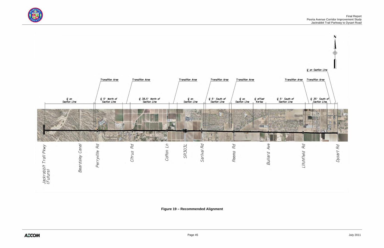
Final Report Peoria Avenue Corridor Improvement Study Jackrabbit Trail Parkway to Dysart Road
Page 45 July 2011
Figure 19 – Recommended Alignment
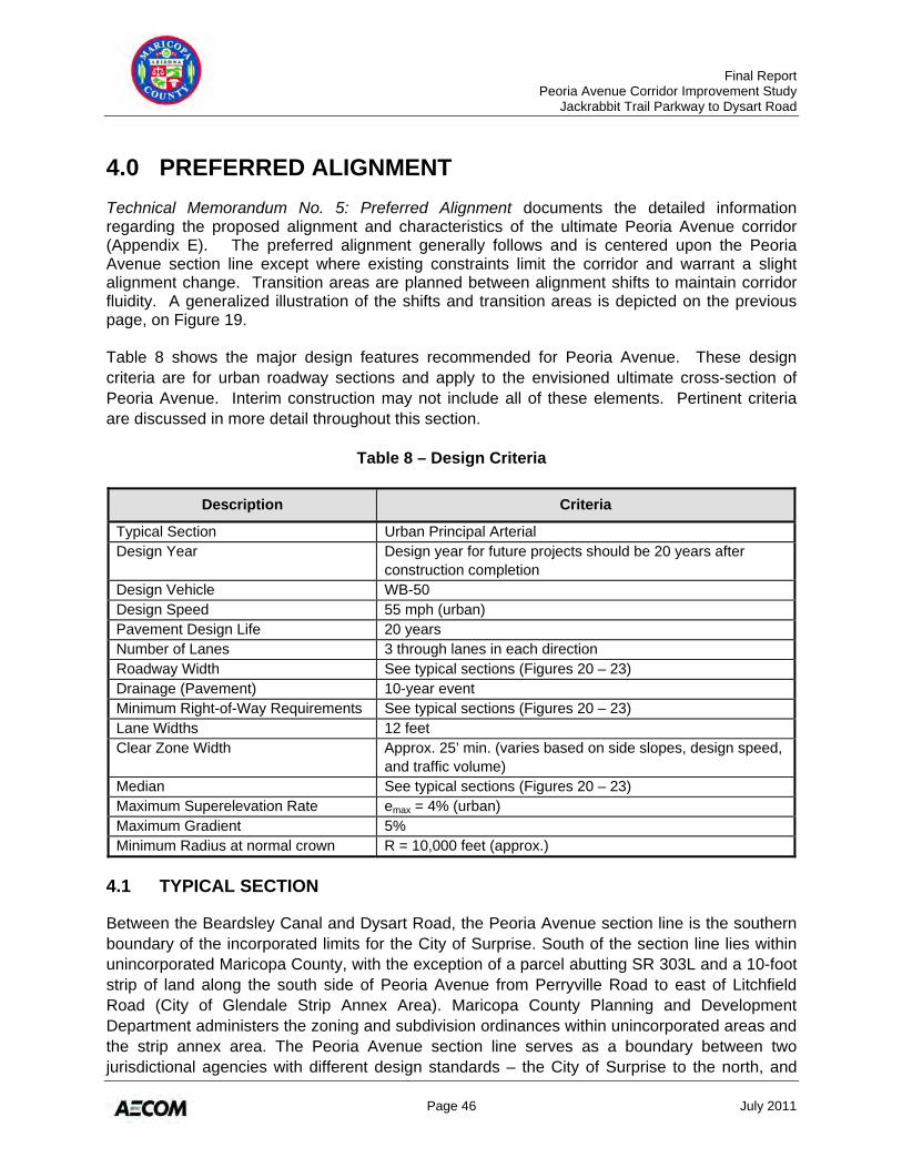
Final Report Peoria Avenue Corridor Improvement Study Jackrabbit Trail Parkway to Dysart Road
Page 46 July 2011
4.0 PREFERRED ALIGNMENT Technical Memorandum No. 5: Preferred Alignment documents the detailed information regarding the proposed alignment and characteristics of the ultimate Peoria Avenue corridor (Appendix E). The preferred alignment generally follows and is centered upon the Peoria Avenue section line except where existing constraints limit the corridor and warrant a slight alignment change. Transition areas are planned between alignment shifts to maintain corridor fluidity. A generalized illustration of the shifts and transition areas is depicted on the previous page, on Figure 19. Table 8 shows the major design features recommended for Peoria Avenue. These design criteria are for urban roadway sections and apply to the envisioned ultimate cross-section of Peoria Avenue. Interim construction may not include all of these elements. Pertinent criteria are discussed in more detail throughout this section.
Table 8 – Design Criteria
Description Criteria
Typical Section Urban Principal Arterial Design Year Design year for future projects should be 20 years after
construction completion Design Vehicle WB-50 Design Speed 55 mph (urban) Pavement Design Life 20 years Number of Lanes 3 through lanes in each direction Roadway Width See typical sections (Figures 20 – 23) Drainage (Pavement) 10-year event Minimum Right-of-Way Requirements See typical sections (Figures 20 – 23) Lane Widths 12 feet Clear Zone Width Approx. 25’ min. (varies based on side slopes, design speed,
and traffic volume) Median See typical sections (Figures 20 – 23) Maximum Superelevation Rate emax = 4% (urban) Maximum Gradient 5% Minimum Radius at normal crown R = 10,000 feet (approx.)
4.1 TYPICAL SECTION
Between the Beardsley Canal and Dysart Road, the Peoria Avenue section line is the southern boundary of the incorporated limits for the City of Surprise. South of the section line lies within unincorporated Maricopa County, with the exception of a parcel abutting SR 303L and a 10-foot strip of land along the south side of Peoria Avenue from Perryville Road to east of Litchfield Road (City of Glendale Strip Annex Area). Maricopa County Planning and Development Department administers the zoning and subdivision ordinances within unincorporated areas and the strip annex area. The Peoria Avenue section line serves as a boundary between two jurisdictional agencies with different design standards – the City of Surprise to the north, and
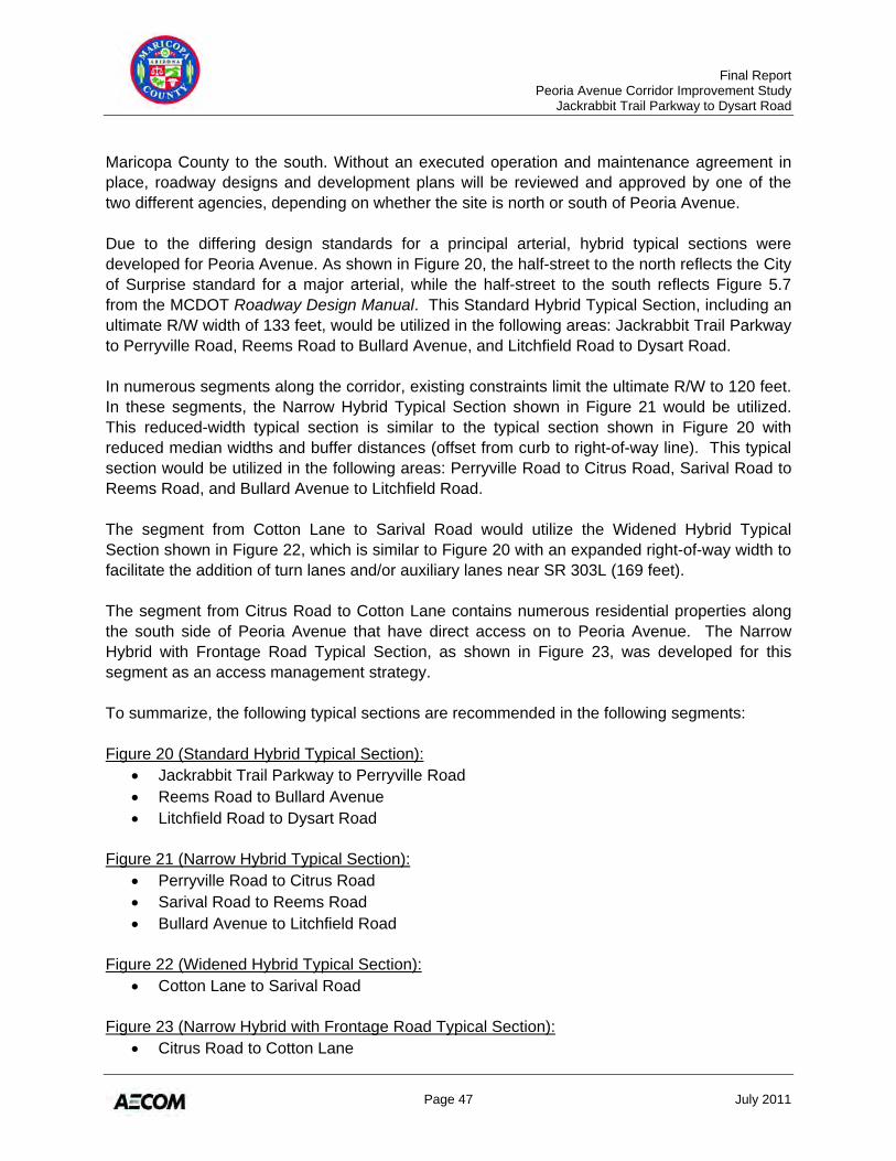
Final Report Peoria Avenue Corridor Improvement Study Jackrabbit Trail Parkway to Dysart Road
Page 47 July 2011
Maricopa County to the south. Without an executed operation and maintenance agreement in place, roadway designs and development plans will be reviewed and approved by one of the two different agencies, depending on whether the site is north or south of Peoria Avenue. Due to the differing design standards for a principal arterial, hybrid typical sections were developed for Peoria Avenue. As shown in Figure 20, the half-street to the north reflects the City of Surprise standard for a major arterial, while the half-street to the south reflects Figure 5.7 from the MCDOT Roadway Design Manual. This Standard Hybrid Typical Section, including an ultimate R/W width of 133 feet, would be utilized in the following areas: Jackrabbit Trail Parkway to Perryville Road, Reems Road to Bullard Avenue, and Litchfield Road to Dysart Road. In numerous segments along the corridor, existing constraints limit the ultimate R/W to 120 feet. In these segments, the Narrow Hybrid Typical Section shown in Figure 21 would be utilized. This reduced-width typical section is similar to the typical section shown in Figure 20 with reduced median widths and buffer distances (offset from curb to right-of-way line). This typical section would be utilized in the following areas: Perryville Road to Citrus Road, Sarival Road to Reems Road, and Bullard Avenue to Litchfield Road. The segment from Cotton Lane to Sarival Road would utilize the Widened Hybrid Typical Section shown in Figure 22, which is similar to Figure 20 with an expanded right-of-way width to facilitate the addition of turn lanes and/or auxiliary lanes near SR 303L (169 feet). The segment from Citrus Road to Cotton Lane contains numerous residential properties along the south side of Peoria Avenue that have direct access on to Peoria Avenue. The Narrow Hybrid with Frontage Road Typical Section, as shown in Figure 23, was developed for this segment as an access management strategy. To summarize, the following typical sections are recommended in the following segments: Figure 20 (Standard Hybrid Typical Section):
• Jackrabbit Trail Parkway to Perryville Road • Reems Road to Bullard Avenue • Litchfield Road to Dysart Road
Figure 21 (Narrow Hybrid Typical Section):
• Perryville Road to Citrus Road • Sarival Road to Reems Road • Bullard Avenue to Litchfield Road
Figure 22 (Widened Hybrid Typical Section):
• Cotton Lane to Sarival Road Figure 23 (Narrow Hybrid with Frontage Road Typical Section):
• Citrus Road to Cotton Lane
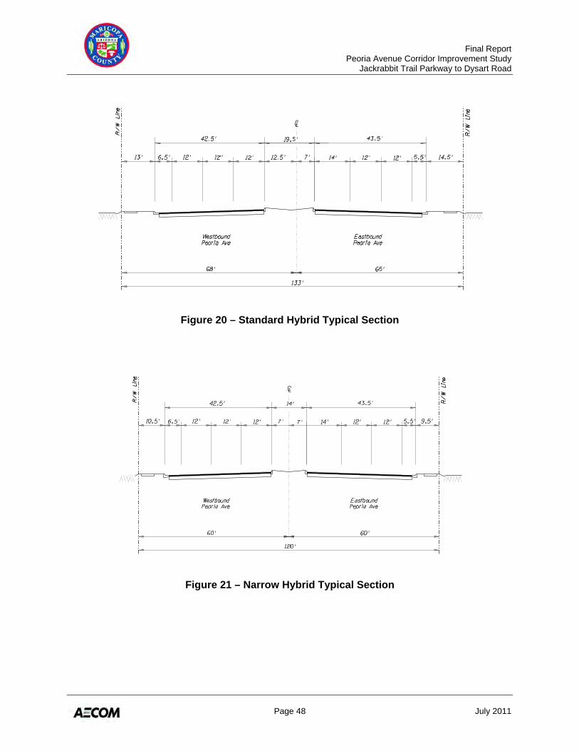
Final Report Peoria Avenue Corridor Improvement Study Jackrabbit Trail Parkway to Dysart Road
Page 48 July 2011
Figure 20 – Standard Hybrid Typical Section
Figure 21 – Narrow Hybrid Typical Section
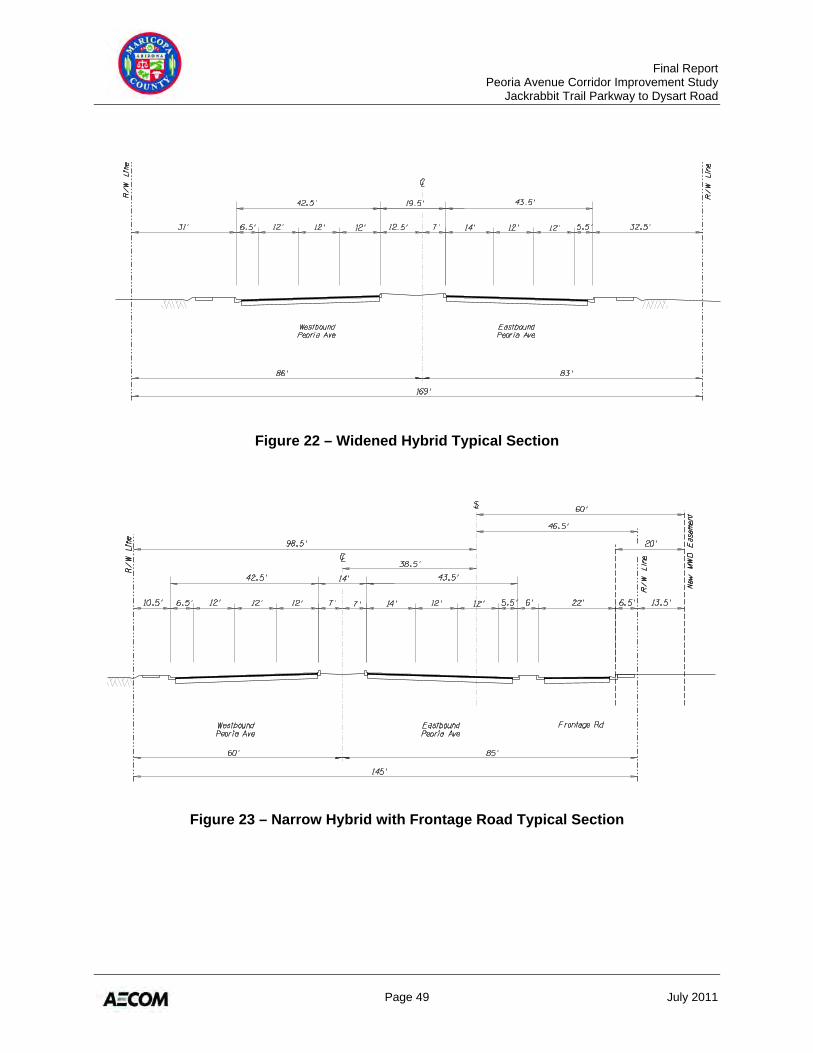
Final Report Peoria Avenue Corridor Improvement Study Jackrabbit Trail Parkway to Dysart Road
Page 49 July 2011
Figure 22 – Widened Hybrid Typical Section
Figure 23 – Narrow Hybrid with Frontage Road Typical Section
Final Report Peoria Avenue Corridor Improvement Study Jackrabbit Trail Parkway to Dysart Road
Page 50 July 2011
4.2 DESIGN FEATURES
Detailed schematic drawings of the preferred alternative can be found in the appendix of Technical Memorandum No. 5 (Appendix E of this document). These drawings show the proposed conceptual alignment for Peoria Avenue, including the proposed centerline, pavement widths, and right-of-way widths. 4.2.1 Geometrics The preliminary corridor alignment recommendations were based on a 140 foot wide corridor. The recommended typical sections vary in width from 120 feet to 169 feet. Therefore, in some segments of the corridor, slight adjustments were made to the recommended centerline location to balance the improvements within the existing right-of-way. The resulting corridor horizontal alignment is shown in Figure 19 and described below. Jackrabbit Parkway to Perryville Road
• Centerline coincident with section line • 5-foot shift to north occurs just west of Perryville Road (55:1 taper)
Perryville Road to Citrus Road
• Centerline 5 feet north of and parallel to the section line • Near Cortessa Parkway, horizontal curvature would shift the centerline to a 38.5-foot
offset north of the section line, west of Citrus Road Citrus Road to Cotton Lane
• Centerline 38.5 feet north of and parallel to the section line Cotton Lane to Sarival Road
• East of Cotton Lane, horizontal curvature would shift the centerline to the south to be coincident with the section line
• Centerline remains coincident with section line to Sarival Road Sarival Road to Reems Road
• 5-foot shift to the south occurs east of Sarival Road (55:1 taper) • Centerline remains 5 feet south of and parallel to the section line • 5-foot shift to the north (to become coincident with the section line) occurs west of
Reems Road (55:1 taper)
Reems Road to Bullard Avenue • Centerline coincident with section line • Approximately 3,000 feet east of Reems Road, horizontal curvature would shift the
centerline 30 feet to the north, and then transition to a 5-foot offset south of the section line, prior to reaching Bullard Avenue
Final Report Peoria Avenue Corridor Improvement Study Jackrabbit Trail Parkway to Dysart Road
Page 51 July 2011
Bullard Avenue to Litchfield Road • Centerline 5 feet south of and parallel to the section line
Litchfield Road to Dysart Road
• East of Litchfield Road, horizontal curvature would shift the centerline to the south to an offset 35 feet south of the section line
• Centerline would continue to the east, 35 feet south of and parallel to the section line for approximately 2,200 feet
• Horizontal curvature would be introduced to shift the alignment back to the section line, west of the Dysart Road
Generally, the vertical alignment would closely follow the existing ground or existing roadway. SR 303L will be constructed to go over Peoria Avenue with Peoria Avenue remaining at-grade. According to the MCDOT Roadway Design Manual, the minimum longitudinal grade should be 0.25 percent, while the City of Surprise standards require a minimum longitudinal grade of 0.30 percent. Therefore, the minimum longitudinal grade should be 0.30 percent. In areas where the existing roadway does not meet this requirement, consideration should be given to increasing the longitudinal slope to meet this minimum requirement. 4.2.2 Drainage For an arterial roadway, Maricopa County Drainage Policies and Standards require a drainage system with the capacity to:
• Maintain one 12-foot dry driving lane in each direction of travel and flow depths not to exceed the curb height for the 10-year storm event.
• Convey the 50-year frequency flow in adjacent channels, with a maximum allowed depth of 6 inches over the pavement surface for the 100-year frequency flow.
• Keep the headwater elevation at culvert crossings below the lowest adjacent road subgrade for the 50-year frequency flow, with a maximum allowed depth of 6 inches over the pavement surface for the 100-year frequency flow.
• Maintain a minimum of 2-feet freeboard below the low chord of bridges for the 100-year frequency flow.
The following off-site and on-site drainage improvements, as well as structural changes, are recommended in order to meet these requirements. Off-Site Improvements
• Mitigation of impacts to the FCDMC 500-year retention basin located south of the McMicken Dam will need to be implemented as a result of Peoria Avenue crossing the basin. Reconfiguration of the basin and/or addition of flood-pool leveling culverts would be needed to retain safety, function, operation, and capacity requirements of the basin. A bridge crossing of Waterfall Wash would be required should the roadway alignment be shifted south of the basin.
Final Report Peoria Avenue Corridor Improvement Study Jackrabbit Trail Parkway to Dysart Road
Page 52 July 2011
• Culvert crossings of Peoria Avenue are proposed to implement a pass-through system for the small washes downstream of the dam in the segment between the basin and the Beardsley Canal.
• The existing channel along the north side of Peoria Avenue at Shadow Ridge High School is planned to be extended east in the development plans of Zanjero Trails and Prasada. A new channel would need to be constructed along the north side of Peoria Avenue from Cotton Lane to the SR 303L channel to provide an ultimate outfall. This channel is not in any development plans at this time and will need to be coordinated with the FCDMC and ADOT for compliance with SR 303L design parameters. A culvert crossing of Peoria Avenue is proposed to discharge into the SR 303L channel downstream of the freeway channel’s box culvert.
• A culvert crossing of Sarival Road and a channel extension to the east is proposed along the north side of Peoria Avenue to allow the conveyance of flows from the Sarival Road Channel to the Greer Ranch channel, mitigating current flooding problems at the Sarival Road intersection.
• A culvert crossing of the intersection of Litchfield Road and Peoria Avenue, and a new channel along the south side of Peoria Avenue are proposed to convey flows from the Copper Canyon channel to the future BNSF Railway (Ennis Spur) Channel. The south side of Peoria Avenue is proposed for the channel because of conflicts with existing development and private retention basins on the north side.
• A pipe culvert that crosses the intersection of Dysart Road and Peoria Avenue will need to be extended as a result of the Peoria Avenue widening. Consequently, a roadside channel along the west side of Dysart Road would need to be relocated for the widened intersection.
On-Site Improvements
• On-site pavement runoff can be collected in catch basins and scuppers along Peoria Avenue, and where needed, conveyed through storm drain laterals to the nearest off-site channel or culvert.
• Segments of Peoria Avenue where there are no off-site channels along the roadway will require storm drain trunk lines to collect flows from laterals and convey them to the nearest outfall, such as the segments from the Beardsley Canal to Perryville Road, SR 303L to Sarival Road, Reems Road to Bullard Avenue, and the BNSF Ennis Spur to Dysart Road.
• Future development on either side of Peoria Avenue may be able to accommodate pavement runoff within their on-site retention and therefore eliminate the need for trunk lines. The on-site retention alternative is more viable where the parcels of land on both sides of the roadway are undeveloped, as opposed to segments where existing private retention basins on one side may have insufficient capacity to accept larger flows from a widened Peoria Avenue half-street.
Final Report Peoria Avenue Corridor Improvement Study Jackrabbit Trail Parkway to Dysart Road
Page 53 July 2011
Structures • Immediately west of Reems Road, a concrete box culvert (CBC) conveys the Reems
Road Channel beneath Peoria Avenue. Based on the ultimate plan for Peoria Avenue, this CBC will need to be extended to accommodate the planned turn lanes and future bus bay.
• A crossing of the Beardsley Canal is planned west of Perryville Road. This crossing could be a CBC or a bridge structure. Coordination will be required with MWD to comply with their crossing requirements and to secure the necessary easements and/or permits to cross their facility.
• A future box culvert crossing under Citrus Road is planned north of Peoria Avenue. This crossing will be in conflict with the existing MWD Cross-Cut Canal. Future design and coordination efforts are needed to address this crossing.
• ADOT’s SR 303L project will construct a new CBC to convey the SR 303L drainage channel beneath Peoria Avenue, and a new two-span bridge to carry SR 303L traffic over Peoria Avenue. It is envisioned that both of these structures will be compatible with the ultimate Peoria Avenue cross-section and that additional improvements will not be necessary.
4.2.3 Trails A planned Maricopa County trails runs along the west side of the Beardsley Canal. At Peoria Avenue, this trail is planned to turn west and may be adjacent to Peoria Avenue. In addition, Maricopa County Parks and Recreation Department is planning a trailhead staging area at the south end of the McMicken Dam. Future studies and designs should plan for an appropriate interface between pedestrian, equestrian, and vehicular movements. 4.2.4 Utilities As improvements to Peoria Avenue are constructed, the MWD facilities will be impacted. MWD Lateral 8, which is located along the south side of Peoria Avenue, will need to be relocated outside of the roadway right-of-way in an MWD easement. In addition, numerous MWD and private well sites will be impacted and will require new wells to replace those that are removed or abandoned with the roadway improvements. Coordination will be required with MWD to relocate these facilities. Appendix E contains a detailed list of the facilities that would likely be impacted, and also contains MWD Easement Guidelines. City utilities along Peoria Avenue include underground water and sewer lines and appurtenances, and a 30-inch reclaimed water line and reclaimed water delivery headers on the south side of Peoria Avenue across from the Surprise South Water Reclamation Plant. The reclaimed water delivery headers will be impacted and will require relocation. Other public utilities along Peoria Avenue include Southwest Gas natural gas lines and Qwest overhead and underground communication lines. A majority of the underground utilities will not be directly impacted by the roadway itself. However, future designs will need to verify that sufficient cover is provided with the new roadway. Relocations may be necessary due to the
Final Report Peoria Avenue Corridor Improvement Study Jackrabbit Trail Parkway to Dysart Road
Page 54 July 2011
drainage facilities associated with the roadway improvements. Utility companies will be responsible for relocation costs if they cannot prove prior rights. 4.2.5 BNSF Ennis Spur The City of Surprise is working with BNSF and private developers to create a new industrial park along the Ennis Spur. New warehouse districts, distribution centers, and commercial enterprises are expected to double the business demand on the BNSF branch in the future. Additionally, BNSF plans to improve the Ennis Spur with construction of a new wye at Grand Avenue (US 60) and a new rail-oriented business park adjacent to Luke Air Force Base, likely causing rail traffic crossing Peoria Avenue to increase in the future. The existing Ennis Spur crossing of Peoria Avenue is at-grade and the improvements shown in Appendix E maintain the at-grade crossing. However, in the future, if the rail traffic using the BNSF Ennis Spur were to increase along with increased vehicular traffic on Peoria Avenue, it may be desirable to implement a grade separated crossing at this location. Future development plans near the Ennis Spur should provide building set-backs to allow the future potential implementation of a grade separated crossing. 4.2.6 Right-of-Way The minimum right-of-way requirements are shown in the hybrid typical section drawings in Section 4.1. Additional right-of-way and/or easements may be needed:
• Generally, for turn lanes, bus bays, drainage facilities, side slopes, utilities, or landscaping
• At the Beardsley Canal crossing, or the retention basin crossing west of the Beardsley Canal
• Between Citrus Road and Cotton Lane to accommodate the proposed frontage road • For the drainage channel along Peoria Avenue, and the MWD irrigation facilities along
the south side of Peoria Avenue Table 9 shows the amount of new right-of-way required for the ultimate corridor. Table 10 does not account for impacts outside of the roadway right-of-way such as drainage easements or MWD easements. A parcel-by-parcel assessment was not conducted to determine the size of the remnant parcels or whether total acquisition is warranted. It is envisioned that a majority of the right-of-way will be obtained through dedications as development of the adjacent land occurs, and only a limited amount will be acquired through actual purchases.
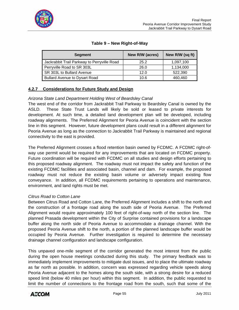
Final Report Peoria Avenue Corridor Improvement Study Jackrabbit Trail Parkway to Dysart Road
Page 55 July 2011
Table 9 – New Right-of-Way
Segment New R/W (acres) New R/W (sq ft)
Jackrabbit Trail Parkway to Perryville Road 25.2 1,097,100 Perryville Road to SR 303L 26.0 1,134,000 SR 303L to Bullard Avenue 12.0 522,390 Bullard Avenue to Dysart Road 10.6 460,460
4.2.7 Considerations for Future Study and Design Arizona State Land Department Holding West of Beardsley Canal The west end of the corridor from Jackrabbit Trail Parkway to Beardsley Canal is owned by the ASLD. These State Trust Lands will likely be sold or leased to private interests for development. At such time, a detailed land development plan will be developed, including roadway alignments. The Preferred Alignment for Peoria Avenue is coincident with the section line in this segment. However, future development plans could result in a different alignment for Peoria Avenue as long as the connection to Jackrabbit Trail Parkway is maintained and regional connectivity to the east is provided. The Preferred Alignment crosses a flood retention basin owned by FCDMC. A FCDMC right-of-way use permit would be required for any improvements that are located on FCDMC property. Future coordination will be required with FCDMC on all studies and design efforts pertaining to this proposed roadway alignment. The roadway must not impact the safety and function of the existing FCDMC facilities and associated basin, channel and dam. For example, the proposed roadway must not reduce the existing basin volume or adversely impact existing flow conveyance. In addition, all FCDMC requirements pertaining to operations and maintenance, environment, and land rights must be met. Citrus Road to Cotton Lane Between Citrus Road and Cotton Lane, the Preferred Alignment includes a shift to the north and the construction of a frontage road along the south side of Peoria Avenue. The Preferred Alignment would require approximately 100 feet of right-of-way north of the section line. The planned Prasada development within the City of Surprise contained provisions for a landscape buffer along the north side of Peoria Avenue to accommodate a drainage channel. With the proposed Peoria Avenue shift to the north, a portion of the planned landscape buffer would be occupied by Peoria Avenue. Further investigation is required to determine the necessary drainage channel configuration and landscape configuration. This unpaved one-mile segment of the corridor generated the most interest from the public during the open house meetings conducted during this study. The primary feedback was to immediately implement improvements to mitigate dust issues, and to place the ultimate roadway as far north as possible. In addition, concern was expressed regarding vehicle speeds along Peoria Avenue adjacent to the homes along the south side, with a strong desire for a reduced speed limit (below 40 miles per hour) within this segment. In addition, the public requested to limit the number of connections to the frontage road from the south, such that some of the
Final Report Peoria Avenue Corridor Improvement Study Jackrabbit Trail Parkway to Dysart Road
Page 56 July 2011
existing north-south streets would not connect to the frontage road. A future box culvert crossing under Citrus Road is planned north of Peoria Avenue. This crossing will be in conflict with the existing MWD Cross-Cut Canal. Future design and coordination efforts will be needed to address this crossing. Realignment West of Bullard Avenue West of Bullard Avenue, the Preferred Alignment includes a northerly shift near the center of the segment to avoid the existing irrigation facilities and well sites. If corridor conditions change in the future (e.g., removal of the irrigation facilities on the south side or new development on the north side) this recommendation should be reconsidered. For example, if development occurs first on the south side of Peoria Avenue, the existing irrigation facilities would likely be relocated as part of the development. If this were the case, then the alignment could stay on the section line and the realignment would not be necessary. However, if development were to occur first on the north side of Peoria Avenue, then the northerly shift should be implemented to avoid relocation of the irrigation facilities. BNSF Ennis Spur The existing BNSF Ennis Spur crossing of Peoria Avenue is at-grade and proposed improvements maintain the at-grade crossing. Future development plans near the BNSF Ennis Spur should provide building set-backs to allow the future implementation of a grade separated crossing, if deemed necessary in the future.
4.3 ACCESS MANAGEMENT GUIDELINES
Access management consists of the planning, design and implementation of land use and transportation strategies that maintain a safe flow of traffic while accommodating the access needs of adjacent properties. Access is managed through the regulation of vehicular access to public roadways from adjoining properties, and vice versa. Management of access is provided through legal, administrative and technical strategies available to political jurisdictions under their police powers to maintain public health, safety and welfare. Access management can be categorized as either full or partial access control. Full access control means that properties abutting a roadway do not have direct access, and that access is provided only at grade-separated interchanges. Partial access control allows some at-grade crossing and some private driveway connections, but only at designated points and often for designated movements (e.g., right-in and right-out only). Uncontrolled access means that all abutting properties are allowed direct access to the roadway. Recommended access management techniques for Peoria Avenue include:
• A divided cross-section with a raised, physical median • Full-access median breaks limited to four per mile • Left turn lanes at all locations where left turns are permitted • Minimum driveway spacing of 200 feet on the north side (City of Surprise) and 165 feet
to 330 feet on the south side (MCDOT)
Final Report Peoria Avenue Corridor Improvement Study Jackrabbit Trail Parkway to Dysart Road
Page 57 July 2011
• Minimum corner clearance at major intersections of 300 feet on the north side (City of Surprise), and 115 feet (approach) or 230 feet (departure) on the south side (MCDOT)
• A frontage road along the south side from Citrus Road to Cotton Lane • No on-street parking
Development policies intended to help achieve access management that can be implemented through future development and redevelopment include:
• Encourage alternative access ways that connect to Peoria Avenue at identified major access points
• Encourage on-site circulation or parallel routes that would discourage direct access to Peoria Avenue
• Encourage the use of direct access to minor roadways connecting to the corridor • Minimize the number of driveways to reduce traffic conflicts
4.4 PLANNING LEVEL COST ESTIMATES
Preliminary planning-level cost estimates for the Preferred Alignment were developed with the following assumptions:
• 6-lane typical section • Two traffic signals per mile (every half-mile) • Underground signal equipment provided at quarter-mile locations • Traffic signal interconnection system for the entire length • No street lighting • 8-foot masonry sound wall adjacent to existing development (actual noise mitigation to
be based on future study at time of construction following current noise abatement policy)
• Eight driveways per mile, per side • Minimal earthwork assuming roadway would be at or near existing ground • Remove and replace existing roadway features • On-site roadway drainage system includes catch basins spaced approximately every
500 feet that discharge into a drainage channel along the roadway • $4 per square foot for right-of-way acquisition
Table 10 summarizes the planning-level cost estimates in 2010 dollars while Table 11 summarizes the costs adjusted for inflation. In addition to construction, several other types of project costs are included in the overall cost estimates:
• Design costs are assumed to be 12 percent of the construction cost • Construction management costs are assumed to be 15 percent of the construction cost • Administration costs are assumed to be 10 percent of the construction cost
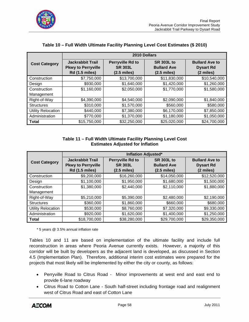
Final Report Peoria Avenue Corridor Improvement Study Jackrabbit Trail Parkway to Dysart Road
Page 58 July 2011
Table 10 – Full Width Ultimate Facility Planning Level Cost Estimates ($ 2010)
Cost Category
2010 Dollars
Jackrabbit Trail Pkwy to Perryville
Rd (1.5 miles)
Perryville Rd to SR 303L
(2.5 miles)
SR 303L to Bullard Ave (2.5 miles)
Bullard Ave to Dysart Rd (2 miles)
Construction $7,750,000 $13,700,000 $11,830,000 $10,540,000Design $930,000 $1,640,000 $1,420,000 $1,260,000Construction Management
$1,160,000 $2,050,000 $1,770,000 $1,580,000
Right-of-Way $4,390,000 $4,540,000 $2,090,000 $1,840,000Structures $310,000 $1,570,000 $560,000 $580,000Utility Relocation $440,000 $7,380,000 $6,170,000 $7,850,000Administration $770,000 $1,370,000 $1,180,000 $1,050,000Total $15,750,000 $32,250,000 $25,020,000 $24,700,000
Table 11 – Full Width Ultimate Facility Planning Level Cost Estimates Adjusted for Inflation
Cost Category
Inflation Adjusted* Jackrabbit Trail
Pkwy to Perryville Rd (1.5 miles)
Perryville Rd to SR 303L
(2.5 miles)
SR 303L to Bullard Ave (2.5 miles)
Bullard Ave to Dysart Rd (2 miles)
Construction $9,200,000 $16,260,000 $14,050,000 $12,520,000Design $1,100,000 $1,950,000 $1,680,000 $1,500,000Construction Management
$1,380,000 $2,440,000 $2,110,000 $1,880,000
Right-of-Way $5,210,000 $5,390,000 $2,480,000 $2,190,000Structures $360,000 $1,860,000 $660,000 $680,000Utility Relocation $530,000 $8,760,000 $7,320,000 $9,330,000Administration $920,000 $1,620,000 $1,400,000 $1,250,000Total $18,700,000 $38,280,000 $29,700,000 $29,350,000
* 5 years @ 3.5% annual inflation rate
Tables 10 and 11 are based on implementation of the ultimate facility and include full reconstruction in areas where Peoria Avenue currently exists. However, a majority of this corridor will be built by developers as the adjacent land is developed, as discussed in Section 4.5 (Implementation Plan). Therefore, additional interim cost estimates were prepared for the projects that most likely will be implemented by either the city or county, as follows:
• Perryville Road to Citrus Road - Minor improvements at west end and east end to provide 6-lane roadway
• Citrus Road to Cotton Lane - South half-street including frontage road and realignment west of Citrus Road and east of Cotton Lane
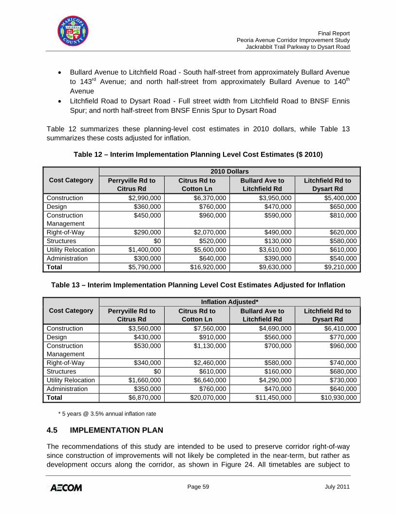
Final Report Peoria Avenue Corridor Improvement Study Jackrabbit Trail Parkway to Dysart Road
Page 59 July 2011
• Bullard Avenue to Litchfield Road - South half-street from approximately Bullard Avenue to 143rd Avenue; and north half-street from approximately Bullard Avenue to 140th Avenue
• Litchfield Road to Dysart Road - Full street width from Litchfield Road to BNSF Ennis Spur; and north half-street from BNSF Ennis Spur to Dysart Road
Table 12 summarizes these planning-level cost estimates in 2010 dollars, while Table 13 summarizes these costs adjusted for inflation.
Table 12 – Interim Implementation Planning Level Cost Estimates ($ 2010)
Cost Category 2010 Dollars
Perryville Rd to Citrus Rd
Citrus Rd to Cotton Ln
Bullard Ave to Litchfield Rd
Litchfield Rd to Dysart Rd
Construction $2,990,000 $6,370,000 $3,950,000 $5,400,000Design $360,000 $760,000 $470,000 $650,000Construction Management
$450,000 $960,000 $590,000 $810,000
Right-of-Way $290,000 $2,070,000 $490,000 $620,000Structures $0 $520,000 $130,000 $580,000Utility Relocation $1,400,000 $5,600,000 $3,610,000 $610,000Administration $300,000 $640,000 $390,000 $540,000Total $5,790,000 $16,920,000 $9,630,000 $9,210,000
Table 13 – Interim Implementation Planning Level Cost Estimates Adjusted for Inflation
Cost Category Inflation Adjusted*
Perryville Rd to Citrus Rd
Citrus Rd to Cotton Ln
Bullard Ave to Litchfield Rd
Litchfield Rd to Dysart Rd
Construction $3,560,000 $7,560,000 $4,690,000 $6,410,000Design $430,000 $910,000 $560,000 $770,000Construction Management
$530,000 $1,130,000 $700,000 $960,000
Right-of-Way $340,000 $2,460,000 $580,000 $740,000Structures $0 $610,000 $160,000 $680,000Utility Relocation $1,660,000 $6,640,000 $4,290,000 $730,000Administration $350,000 $760,000 $470,000 $640,000Total $6,870,000 $20,070,000 $11,450,000 $10,930,000
* 5 years @ 3.5% annual inflation rate
4.5 IMPLEMENTATION PLAN
The recommendations of this study are intended to be used to preserve corridor right-of-way since construction of improvements will not likely be completed in the near-term, but rather as development occurs along the corridor, as shown in Figure 24. All timetables are subject to
Final Report Peoria Avenue Corridor Improvement Study Jackrabbit Trail Parkway to Dysart Road
Page 60 July 2011
change, depending on such circumstances as identification of additional funding, new opportunities for cost-sharing with partner jurisdictions, and development of land adjacent to Peoria Avenue. In the near-term, projects that are already programmed should be completed, such as improvements at the SR 303L/Peoria Avenue interchange to be constructed by ADOT when SR 303L is upgraded to a freeway facility, as well as the City of Surprise planned completion of the north half-street between Sarival and Reems Roads. Other near-term improvements recommended for consideration include:
• Acquire right-of-way and construct a two-lane roadway between Citrus Road and Cotton Lane
• Drainage improvements at Litchfield and Sarival Roads Assuming completion of the segments to be implemented by developers, several additional improvement projects would be needed in the mid-term timeframe to provide a continuous 4-lane facility by the year 2030, including:
• South half-street and frontage road construction between Citrus Road and Cotton Lane • Cotton Lane intersection improvements • Reems Road intersection improvements • South half-street construction between Bullard Avenue and Litchfield Road • South half-street construction between Litchfield Road and BNSF Ennis Spur
Long-term (likely beyond 2030) improvements will focus on bringing uniformity to the corridor and widening to the ultimate 6-lane facility. Areas where these improvements would occur include:
• Perryville Road to Citrus Road • Sarival Road to Reems Road • Bullard Road to Litchfield Road • Litchfield Road to Dysart Road
The MCDOT Transportation Improvement Program (TIP), updated annually, is based on a 5-year projection of available transportation funding and a countywide prioritization of roadway system needs. No projects (Design Concept Report, design, or construction) along this portion of Peoria Avenue are a part of the current 5-year TIP.
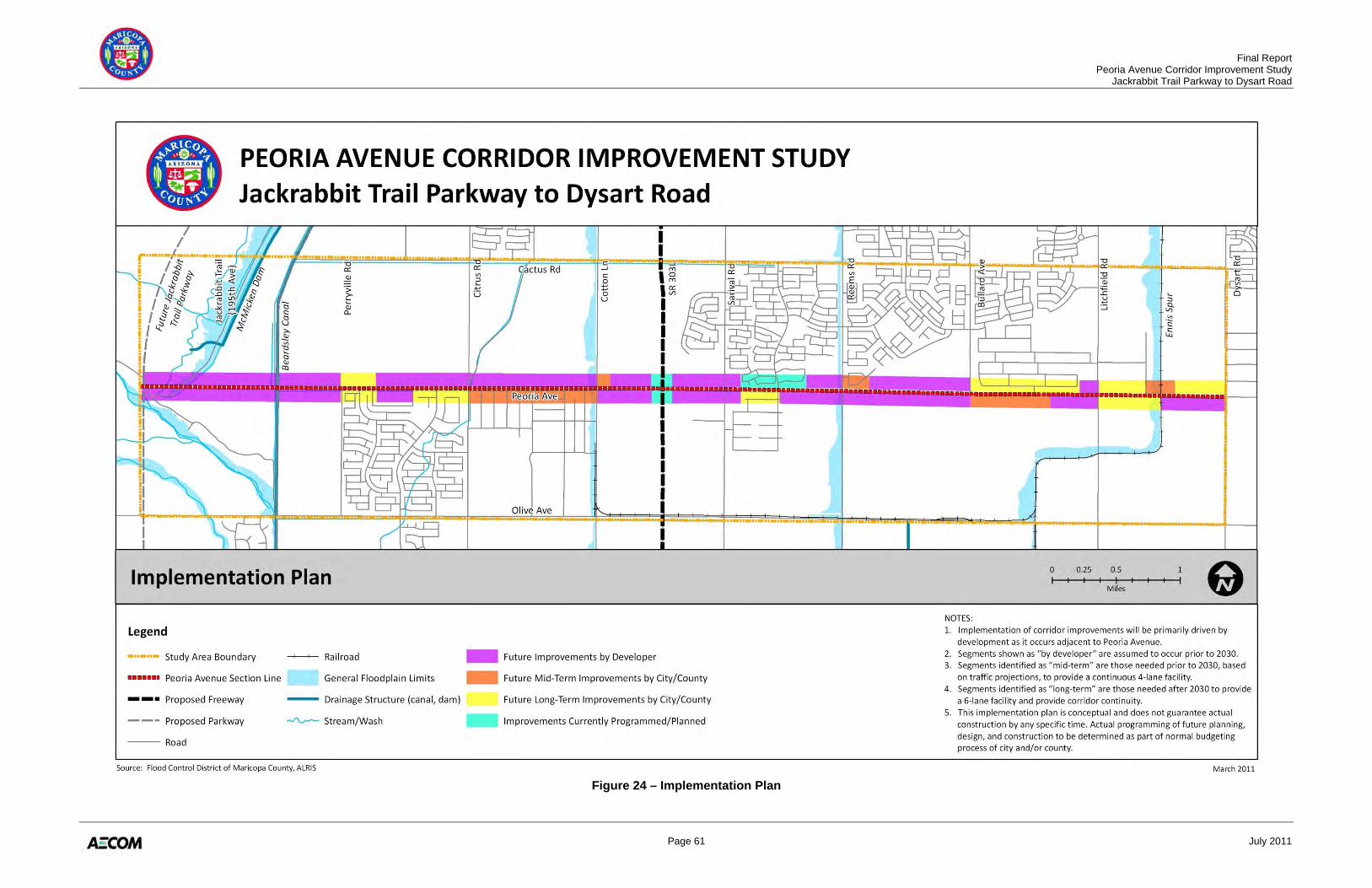
Final Report Peoria Avenue Corridor Improvement Study Jackrabbit Trail Parkway to Dysart Road
Page 61 July 2011
Figure 24 – Implementation Plan
Final Report Peoria Avenue Corridor Improvement Study Jackrabbit Trail Parkway to Dysart Road
Page 62 July 2011
5.0 PUBLIC INVOLVEMENT OVERVIEW This section summarizes the MCDOT RightRoads public and stakeholder involvement process, as documented in Technical Memorandum No. 6: Public and Stakeholder Participation (Appendix F) and MCDOT’s RightRoads Summary of Public and Stakeholder Involvement (Appendix H). Gaining consensus among stakeholder agencies and the public is critical to the success of this transportation study, as well as the future implementation of its recommendations to provide a long-term functional and efficient transportation corridor.
5.1 TECHNICAL ADVISORY COMMITTEE
A Technical Advisory Committee (TAC) was established to solicit feedback from partnering agencies and key stakeholders at multiple stages of the corridor improvement study. Members of the TAC include:
• Maricopa County (Transportation, Engineering, Traffic, Planning and Development, Environmental, Cultural Resources, Parks and Recreation, Intergovernmental Relations, Real Estate, Utilities)
• Flood Control District of Maricopa County (FCDMC) • Maricopa Association of Governments (MAG) • Arizona Department of Transportation (ADOT) • Arizona Game and Fish Department (AGFD) • Arizona State Land Department (ASLD) • Arizona Public Service (APS) • City of El Mirage • City of Glendale • City of Surprise • Dysart School District • Luke Air Force Base • Maricopa Water District (MWD) • Major land developers
The role and responsibility of the TAC was to meet at key decision point during the study to receive an update on project progress, as well as offer advice and guidance on study issues. The TAC was asked to review and comment on all draft technical memoranda and the draft final report. Five separate TAC meetings were planned over the course of the study:
• The first TAC meeting was held on August 23, 2010. The purpose of this meeting was to initiate the MCDOT Peoria Avenue Corridor Improvement Study, define the role of the TAC, gather information relative to the study needs, and share next steps with the committee. Preparations were made for the first public open house.
Final Report Peoria Avenue Corridor Improvement Study Jackrabbit Trail Parkway to Dysart Road
Page 63 July 2011
• The second TAC meeting was held on October 12, 2010. The meeting presented study area issues, constraints, and opportunities learned through the development of the first three technical memoranda, discussed potential alternatives and evaluation criteria, gathered additional information from TAC members to consider as the next phase of the project progressed, and shared next steps. Traffic volume information was presented to determine the corridor’s ultimate typical section parameters.
• The third TAC meeting was planned for November 2010, but was cancelled and instead, information was disseminated through email to gain consensus on evaluation criteria and alternative corridor scenarios.
• The fourth TAC meeting was held on December 14, 2010. The meeting discussed progress on the alternatives development, evaluation, and preliminary recommendations; and gathered pertinent information to complete the evaluation. Planning efforts for the second public open house were discussed.
• The fifth TAC meeting was held on February 15, 2011. The meeting presented the results of the alternatives evaluation process, discussed design features of the recommended alignment, and preliminary implementation plan.
Minutes and meeting materials for all TAC meetings may be found in Appendix F.
5.2 PUBLIC MEETINGS
Three public meetings were held during the course of the Peoria Avenue Corridor Improvement Study, all located at Shadow Ridge High School, positioned at the western end of the study corridor. All meetings were conducted in an open house format which provided a free and open exchange of information between area residents with specific issues or questions and the project team. Study fact sheets and comment cards were distributed to all those in attendance.
• The first meeting was held for scoping purposes (September 20, 2010) to provide area residents and impacted stakeholders an opportunity to inform project team members about study area issues and local transportation needs. This meeting also provided project team members an opportunity to present and elicit feedback on the study purpose, process, and goals and objectives.
• The second meeting was held to discuss alternatives development and analysis (January 18, 2011), presenting three separate alternative alignment options in each of the nine corridor segments – allowing a myriad of preferred corridor recommendations. Proposed roadway cross sections and the project team’s preliminary evaluation were presented for public review and comment. Out of this meeting, a series of additional alignment options were requested for consideration by the public for the western portion of the study area between Cotton Lane and the future Jackrabbit Trail Parkway.
• The third meeting focused on the findings and recommendations of the Peoria Avenue Corridor Improvement Study (March 22, 2011). The evaluated alternatives along with the recommended roadway cross section and future roadway alignment was presented for public review and comment. Positive feedback was received on the preferred alignment and innovative solutions presented to accommodate corridor obstacles.
Final Report Peoria Avenue Corridor Improvement Study Jackrabbit Trail Parkway to Dysart Road
Page 64 July 2011
The following outreach methods were used to inform and notify the general public and impacted residents about the study and meeting dates and locations:
• Media releases • Newspaper articles • Display advertisements in local and regional publications • MCDOT website • Partner agency mediums • Direct mail flyers to adjacent property owners and previous meeting attendees
Meeting flyers, newspaper notices and articles, and information presented at all three public meetings may be found in Appendix H.