Embed Size (px)
Citation preview
W H I T I N G M I N I N G S E R V I C E S I N T E R N A T I O N A L LTD. -- 1 0 3 s G R E E N W O O D P L A C E , W E S T V A N C O U V E R , B . C , C A N A D A . V I S - l V 2
PERCUSSION DRILLING REPORT
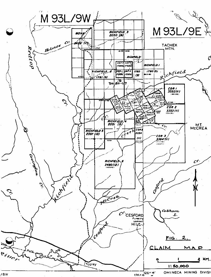
Richfield #1, $12, #3, #4, #5, # 6 , CDF #1, #2, & #3 Mineral Claims. Omineca M.D.
Latitude : N 54O34'; Longitude W 126' 14'
NTS : 93 L 9 E & 9 W.
Work Program Carried out by Cobre Exploration Ltd.
Consultants : Whiting Mining Services International Ltd.
Author: F.B. Whiting, Geological Engineer,
Ph.D, P.Eng.
Date of Work : Nov. 28 - Dec. 7 , 1980
Date of Report : May 19, 1981.
Record # 1780 (5) 11 1781 ( 5 )
2050 (9) 2051 (9)
I t 2397 (12) II 3480 (12) II 1727 (4) 11 1728 (4) I1 1729 (4)
11
II
Q TAFLF OF' CONTENTS
Item Page
A.
B.
C.
D.
E.
INTSODUCTION 1.
TECHNICAL DATA & IMTEWRETATION 2.
ITEMIZED COST STATEMENT 5.
STATEMENT OF QUALIFICATIONS 6.
LOG SHEET 7.
LIST OF ILLUSTRATIONS
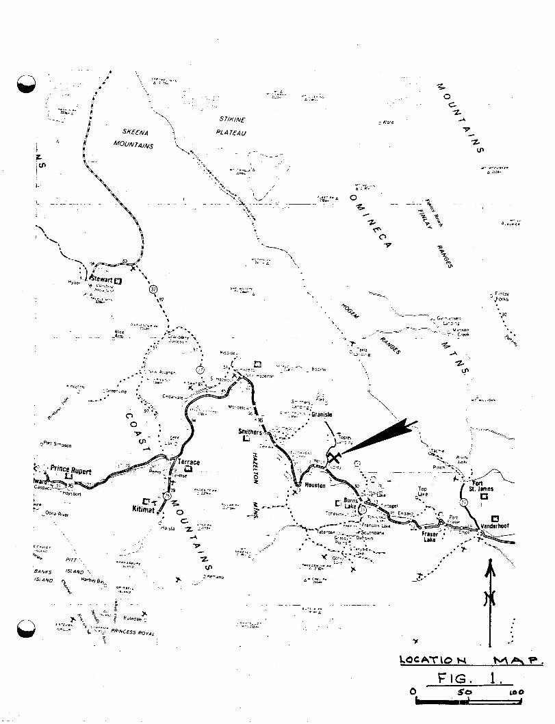
Fig. 1 : Location Map
Fig. 2 : Claim Map
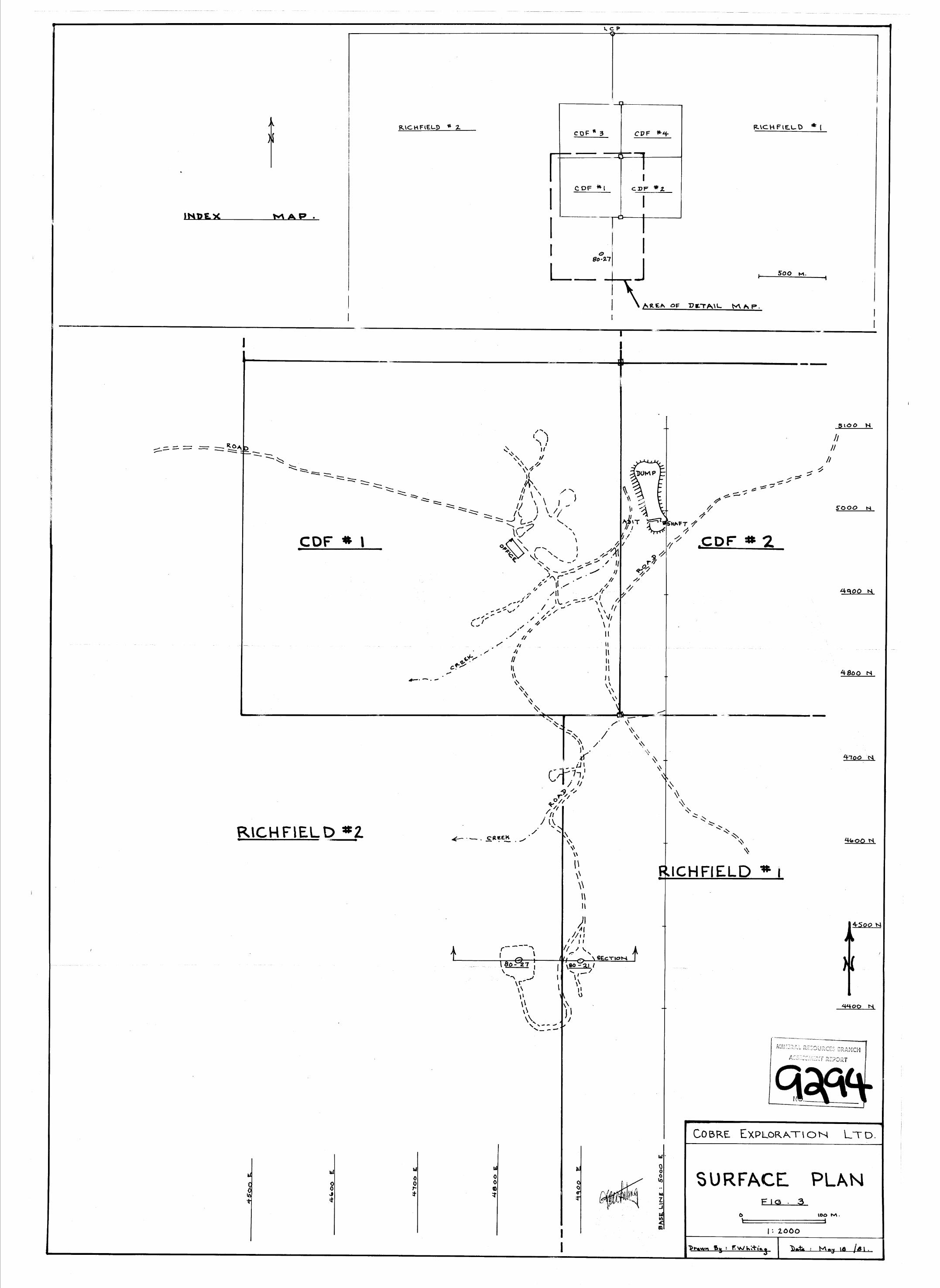
Fig. 3 : Surface Plan . In pocket.
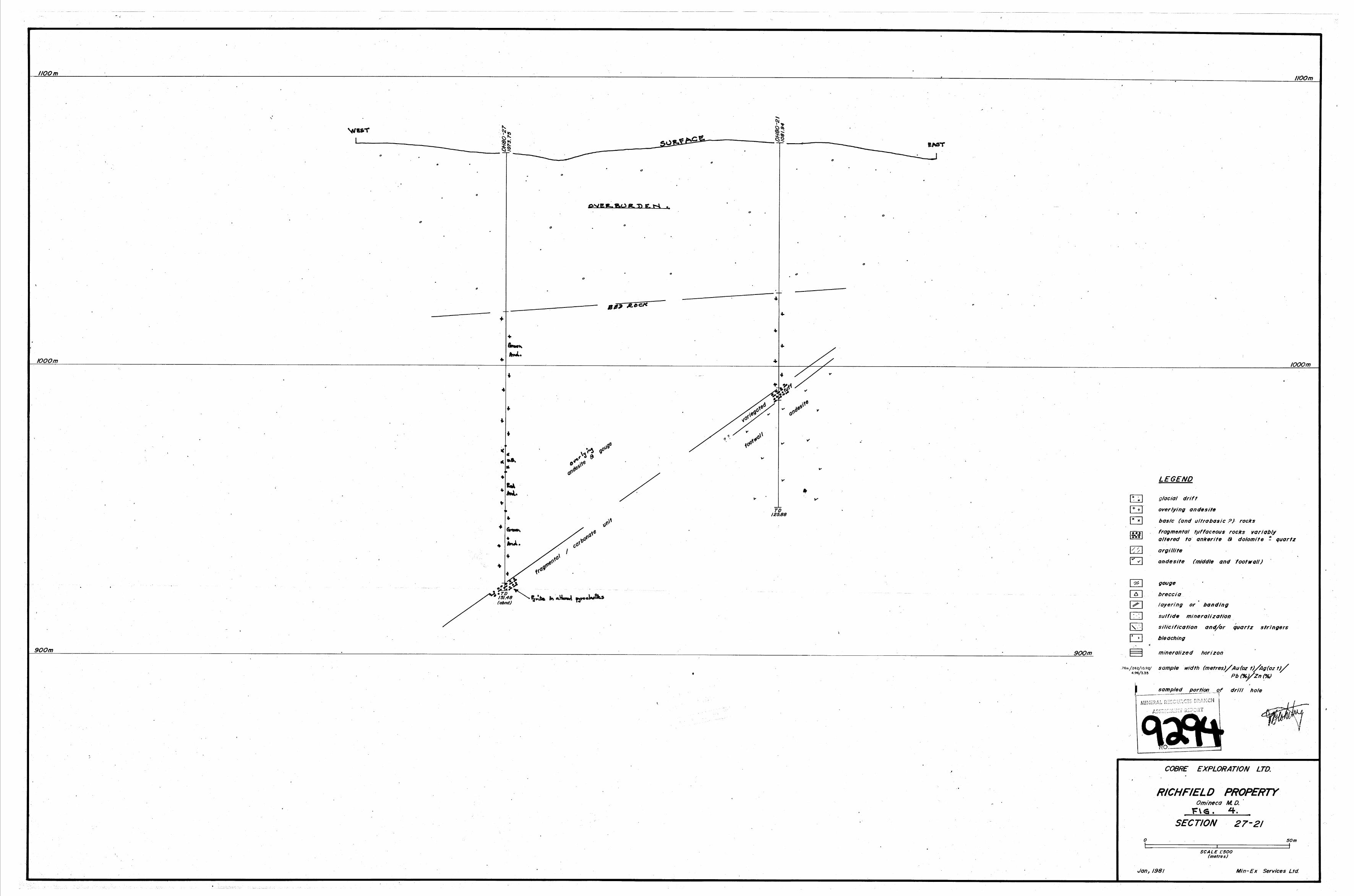
Fig. 4 : Cross Section, Holes 80-21 & 80-27. In pocket.
1.
A. INTRODUCTION
PROPERTY & LOCATION
The Richfield claims are situated from 4 to 13 km north
of Topley, B.C., in the Omineca M.D., on NTS maps 93 L 9E and 9W,
at elevations of 1000-1400 m, at Latitude N 54'34', Longitude
W 126O 14'. Access is by a dirt road that branches from the
Topley-Granisle Highway 10 km north of Topley & thence 3 km east
to the work site.
HISTORY
The showings were discovered in 1927, and work was
carried out on surface and on two underground levels from
1928 to 1929. The workings were de-watered and sampled by
Silver standard Mines in 1954-57. ,Four holes were drilled
by Canadian Superior Explorations in 1975. Geophysical
surveys were made by Cobre Exploration Ltd in late 1979,
and that company drilled many holes in the period April-December
1980 . This report covers the final hole drilled after
November 27, 1980, and the road work for access to the
drilling site, plus reclamation. A report filed earlier
covered the previously-drilled holes.
ECONOMIC POTENTIAL
Reserves indicated by the old mine workings and the
LOCAT\o N h e . FIG. 1.
0
. MT. McCREA
Q /
2.
1980 drilling amount to 200,009 ‘tons grading 3.8 grams
of gold per ton and 174 gms silver per ton, with minor
lead, zinc, copper, and cadmium. The deposit is of the
volcanogenic type and offers the potential for finding
much larger tonnages.
WORK SUMMARY
The work covered by this report includes the
drilling of Hole # 80-27 to a depth of 151.48 metres,
road construction to the drilling site, and reclamation
work in cutting fallen trees into short lengths as
required by the Mines Inspector. Logging and report
preparation and map drafting costs are included. The hole
diameter was 5 1/2 inches. The road is 300 m long, 6 m wide.
The work was done on the Richfield # 2 M.C.,
record # 1781 ( 5 1 . Some of the road construction was
on Richfield 81 M.C., tS 1 7 8 0 ( 5 ) .
B. TECHNICAL DATA & INTERPRETATION
Purpose of Drilling, and Result
Earlier drillholes had found good-grade gold-
silver mineralization as beds within a sequence of acidic
pyroclastic rocks belonging to the Jurassic Hazelton formation.
3.
The host beds strike north and dip west at about
45'. Hole 80-27 was drilled as a step-out to the south
to follow the host unit and test it for repetitions of the
mineralized layers. The hole was drilled with a combined
rotary and down-the-hole percussion rig; it was planned to
stop this type of drilling once the beds overlying the
ore-host unit had been penetrated and to then move a
coring drill on to the site to extend the hole by coring
through the potential ore layer.
The hole encountered 54.86 m of overburden and
then entered the overlying formation which consists of
chloritized andesite with some layers of ultrabasic rock.
It penetrated into the acidic pyroclastic host unit for
a length of 2.14 m, showing cuttings with strong alteration
and considerable pyrite. The rotary/percussion drill was
then moved off. Owing to technical problems and the onset
of extremely cold weather the coring drill was not put on
the hole in December, 1980; it is planned to complete the
hole through the ore-host unit in 1981.
Conclusions:
The presence of strong alteration in the tuffaceous
beds, plus the presence of pyrite right at the top of that
unit , are considered to suggest that mineralization can be expected to occur some tens of metres below the point
4 .
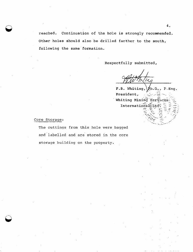
reached. Continuation of the hole is strongly recommended.
Other holes should also be drilled farther to the south,
following the same formation.
Respectfully submitted,
Core S t o r a s e :
The c u t t i n g s from t h i s h o l e w e r e
and label led and a r e s t o r e d i n t h e core
s t o r a g e b u i l d i n g on t h e p r o p e r t y .
I
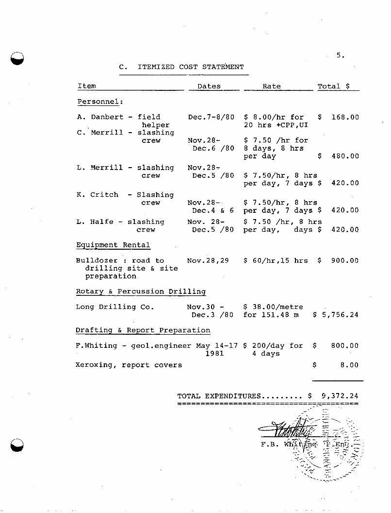
n 5. C. ITEMIZED COST STATEhENT
I tem Dates Rate Total $
Personnel:
A . Danbert - field C. Merrill - slashing
helper
crew
L. Merrill - slashing crew
K. Critch - Slashing crew
L. Halfe - slashing crew
Equipment Rental
Bulldozer : road to drilling site & site preparation
Dec.7-8/80 $ 8.00/hr for $ 168.00 20 hrs +CPP,UI
Nov.28- $ 7.50 /hr for Dec.6 /80 8 days, 8 hrs
per day $ 480.00 Nov.28- Dec.5 /80 $ 7.50/hr, 8 hrs
per day, 7 days $ 420.00
Nov.28- $ 7.50/hr, 8 hrs
NOV. 28- $ 7.50 /hr, 8 hrs Dec.4 & 6 per day, 7 days $ 420.00
Dec.5 /80 per day, days $ 420.00
Nov.28,29 $ 60/hr,15 hrs $ 900.00
Rotary & Percussion Drillinu
Long Drilling Co. N0v.30 - $ 38.OO/metre Dec.3 /80 for 151.48 m $ 5,756.24
Draftinu & Renort Prenaration
F.Whiting - geol.engineer May 14-17 $ 200/day for $ 800.00
Xeroxing, report covers $ 8.00 1981 4 days
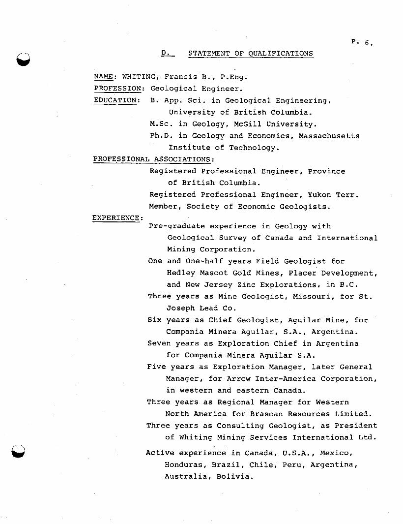
D. STATEMENT OF @UALIFICATIONS
NAME: WHITING, Francis B., P.Eng. - PROFESSION: EDUCATION:
Geological Engineer. B. App. Sci. in Geological Engineering,
University of British Columbia. M.Sc. in Geology, McGill University. Ph.D. in Geology and Economics, Massachusetts
Institute of Technology. PROFESSIONAL ASSOCIATIONS:
Registered Professional Engineer, Province
Registered Professional Engineer, Yukon Terr. Member, Society of Economic Geologists.
Pre-graduate experience in Geology with Geological Survey of Canada and International
of British Columbia.
EXPERIENCE :
Mining Corporation. One and One-half years Field Geologist for
Hedley Mascot Gold Mines, Placer Development, and New Jersey Zinc Explorations, in B.C.
Three years as Mine Geologist, Missouri, for St. Joseph Lead Co.
Six years as Chief Geologist, Aguilar Mine, for Compania Minera Aguilar, S.A., Argentina.
Seven years as Exploration Chief in Argentina for Compania Minera Aguilar S.A.
Manager, for Arrow Inter-America Corporation, Five years as Exploration Manager, later General
in western and eastern Canada. Three years as Regional Manager for Western
North America for Brascan Resources Limited. Three years as Consulting Geologist, as President
of Whiting Mining Services International Ltd.
Active experience in Canada, U.S.A., Mexico, Honduras, Brazil, Chile, Peru, Argentina, Australia, Bolivia.
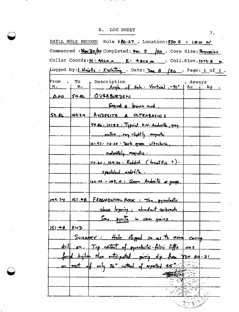
13 E. LOG SHEET 7.
DRILL HOLE RECORD Hole #86-27 : L0cation:SSo 5 - lea W
Q