Embed Size (px)
Citation preview

1
Snapshot of Medusa: Un-hedged, low cash cost, gold
producer focused on organic growth in the Philippines and Southeast Asia
No long-term debt
Board of Directors: Andrew Teo (Non-executive Chairman)
Boyd Timler (Managing Director)
Raul Villanueva (Executive Director)
Roy Daniel (Non-executive Director)
Management: Boyd Timler (Managing Director)
Raul Villanueva (President, Philippine subsidiaries)
Peter Alphonso (Chief Financial Officer / Company Secretary)
James Llorca (Manager of Geology & Resources)
David McGowan (General Manager, Engineering)
Capital Structure: Ordinary shares: 207,794,301 Unlisted options: 6,030,000
Listing: ASX (Code: MML)
Address and Contact Details: Suite 10, 100 Mill Point Road South Perth, WA 6151 Australia
PO Box 122 South Perth, WA 6951 Australia
Telephone: +618 9474 1330 Facsimile: +618 9474 1342 Email: [email protected] Website: www.medusamining.com.au
OVERVIEW: Co-O MINE PRODUCTION Production: 25,056 ounces at average head grade of 6.67 g/t gold (Sep
2017 qtr: 24,896 ounces at average grade of 6.59 g/t gold).
Cash Costs: of US$523 per ounce (Sep 2017 qtr: US$565 per ounce).
All-In-Sustaining-Costs (“AISC”): US$1,025 per ounce (Sep 2017 qtr: US$973 per ounce).
Mill Performance: gold recovery averaged 94.9% (Sep 2017 qtr: 94.6%).
Mine Development: Total advance was 5,765 metres of horizontal and vertical development (Sep 2017 qtr: 6,371 metres).
Mine Infrasturcture Projects: - E15 Service Shaft: Reached depth of 446 metres, 12 metres below
the 9 level. - Main Levels and Winzes: Development on Level 9 totalled 964 metres,
with an additional 113 metres developed on Level 10.
Revised Production Guidance (2017/18): The FY17-18 production guidance was revised upwards to 85,000 to 95,000 ounces, at AISC of between US$1,000 to US$1,150 per ounce of gold produced during the quarter.
Co-O MINE EXPLORATION Surface and Underground resource drilling
Total drilling for the quarter was 4,686 metres. The breakdown as follows: - Reserve drilling Levels 6, 7 & 9 from 13 drill holes totalled 1,489
metres. - Resource definition drilling at Level 8, from 7 drill holes totalled 3,197
metres. - Results from the resource drilling include 0.85 metres @ 252.6 g/t
gold, 0.60 metres @ 110.7 g/t gold, 0.30 metres @ 319.6 g/t gold, and 0.50 metres @ 221.7 g/t gold.
REGIONAL & NEAR MINE EXPLORATION Near Mine Exploration (MinEx): continued the reconnaissance activities
within the mine environs.
RESOURCES & RESERVES
Currently completing the annual review and update to its Mineral Resource and Ore Reserve estimates using 31 Decembr 2017 as the data cut-off. This update will be reported by next quarter.
CORPORATE & FINANCIALS Total cash and cash equivalent of gold on metal account at the end of the
quarter was approximately US$16.7 million (Sep 2017 Qtr: US$16.8 million).
Executed a Memorandum of Understanding on 10 January 2018 for an Earn-In Agreement for exploration tenement in Cambodia
QUARTERLY ACTIVITIES REPORT
PERIOD ENDED 31 December 2017
For
per
sona
l use
onl
y

2
TENEMENT PROJECT OVERVIEW
The locations of the Company’s Tenement on Figure 1.
Figure 1: Location diagram showing the company’s Tenements covering the Co-O mine and mill operations areas.
For
per
sona
l use
onl
y

3
Co-O MINE
PRODUCTION The production statistics for the December 2017 Quarter and comparatives for the previous three quarters are summarised in Table I below.
“The H1 results total 49,952 ounces of gold produced at a feed grade of 6.63 g/t”.
Table I. Gold production statistics
Description Unit Mar 2017 Quarter
Jun 2017 Quarter
Sep 2017 Quarter
Dec 2017 Quarter
Dec 2017 Half-Year
Ore mined WMT 140,865 139,967 143,317 129,624 272,941
Ore milled DMT 122,960 123,670 121,616 124,916 246,532
Head grade g/t 4.93 6.38 6.59 6.67 6.63
Recovery % 94.3% 94.4% 94.6% 94.9% 94.7%
Gold produced ounces 18,390 23,846 24,896 25,056 49,952
Gold sold ounces 17,837 22,296 27,602 25,550 53,152
U/G development metres 6,004 5,671 6,371 5,765 12,136
Cash costs (*) US$/ounce $644 $539 $565 $523 $544
All-In-Sustaining-Costs (“AISC”) US$/ounce $1,555 $1,180 $973 $1,025 $999
Average gold price received US$/ounce $1,229 $1,252 $1,274 $1,281 $1,278
Cash & cash equivalent US$M $10.6M $11.5M $16.8M $16.7M $16.7M
Note: (*) Net of capitalised development costs and includes royalties and local business taxes.
The Company produced 25,056 ounces of gold for the quarter, at an average head grade of 6.67 g/t gold from 124,914 tonnes of ore processed. Tonnes processed was restricted by mine ore hoisting, while mill feed grade was influenced by better quality development ore and a higher proportion of stope ore in the mill feed blend.
The overall ore mined for the quarter was down from previous quarters, reflected reduced production through December. The L8, Baguio and Agsao shafts was shut down during December for major planned maintenance. All planned work was completed on time.
The mine completed a total of 5,765 metres of development. Of this, 3,090 metres was horizontal, and 2,675 metres was vertical development. Development also continued on Level 10.
All-In-Sustaining-Costs (“AISC”) for the December 2017 quarter was US$1,025 per ounce of gold and for the half year to 31 Dec 2017 (“H1”), the YTD AISC was US$999 per ounce of gold.
The Dec 2017quarter AISC also includes some exceptional costs: • E15 Service Shaft hardware and surface civil works for future infrastructure (shaft steel, level
bridges, buildings, etc.); • upgrades to the mine water treatment plant (ponds, filter house and warehouse relocation
costs); and • Tailings Storage Facility (“TSF #5) upstream diversion dam #2 and diversion channel.
The in-stope broken ore inventory at the end of the quarter was 45,891 tonnes (WMT) at 7.45 g/t gold. This is an improvement in both tonnes and grade from the Sep 2017 quarter.
For
per
sona
l use
onl
y

4
Production Shafts Overall material hoisted was 123,525 tonnes (DMT) for ore and waste combined.
• Level 8 Shaft: Planned major winder and shaft maintenance carried out in December was carried through into the first week of January as planned, taking advantage of the reduced workforce numbers over the festive season
• Agsao Inclined Shaft: Material hoisted is down with reduced workforce numbers over the festive season. Shaft maintenance was conducted during this time.
• Baguio Inclined Shaft: Material hoisted is down with reduced workforce numbers over the festive season. Shaft maintenance was conducted during this time.
• L8 Winzes: 29E and 12E Winzes continued to hoist material from Level 9 and Level 10 to Level 8. The 43E Winze has now reached the Level 10 and horizontal development has commenced. Priority will be to connect with the 12E winze.
The 48E Winze is near Level 10 by the end of the quarter. The 35E Winze winder was established and development of the winze has recommenced and has reached 29 metres.
For the Sep 2017 quarter, there was a total of 705 metres of horizontal development and 372 metres of vertical development on Levels 9 and 10. Stoping activities continued on Level 9.
Figure 2: 3D Isometric view of Co-O mine showing all historic mine development, plus the December 2017 Quarters horizontial development in Pink,
also showing the primary vertical development in Brown and Green. E15 is shown here at Level 8, with design to Level 10 (+24 metres)
For
per
sona
l use
onl
y
5
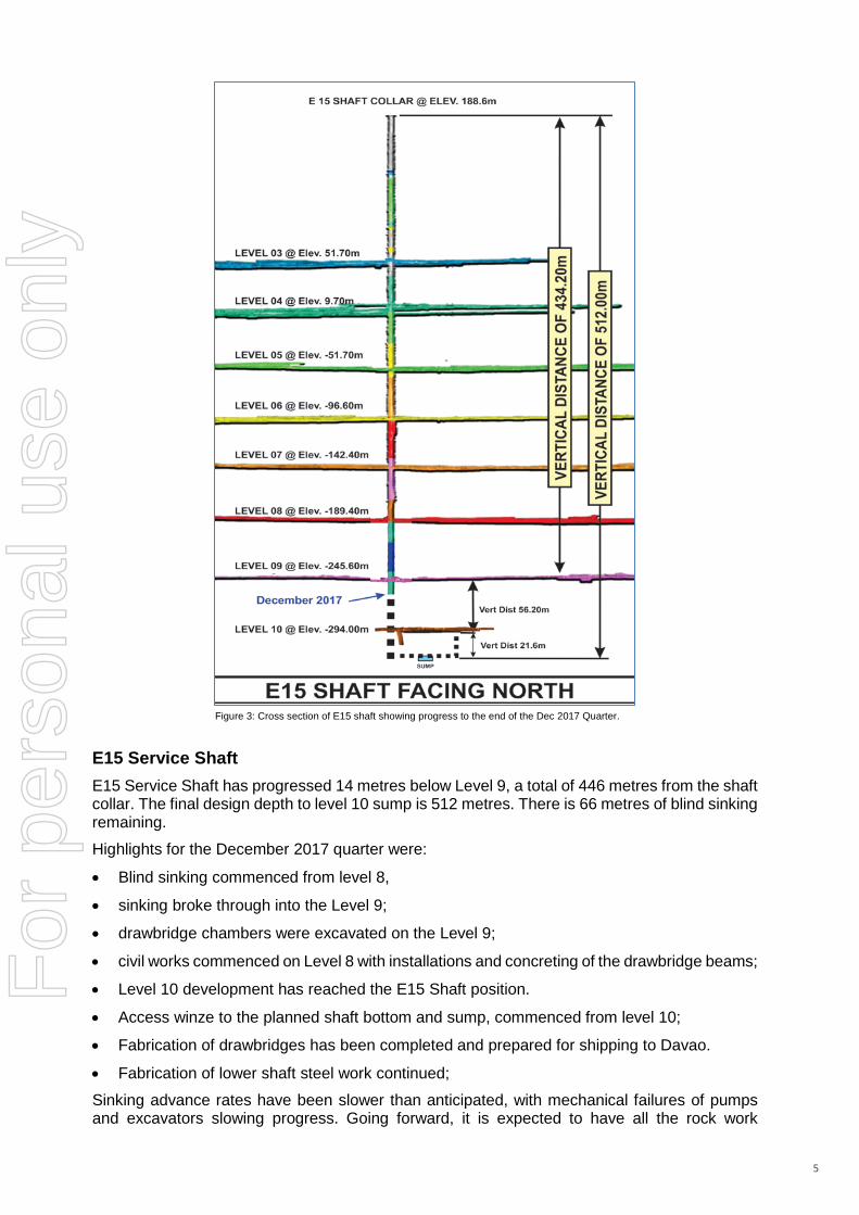
Figure 3: Cross section of E15 shaft showing progress to the end of the Dec 2017 Quarter.
E15 Service Shaft E15 Service Shaft has progressed 14 metres below Level 9, a total of 446 metres from the shaft collar. The final design depth to level 10 sump is 512 metres. There is 66 metres of blind sinking remaining.
Highlights for the December 2017 quarter were:
• Blind sinking commenced from level 8,
• sinking broke through into the Level 9;
• drawbridge chambers were excavated on the Level 9;
• civil works commenced on Level 8 with installations and concreting of the drawbridge beams;
• Level 10 development has reached the E15 Shaft position.
• Access winze to the planned shaft bottom and sump, commenced from level 10;
• Fabrication of drawbridges has been completed and prepared for shipping to Davao.
• Fabrication of lower shaft steel work continued;
Sinking advance rates have been slower than anticipated, with mechanical failures of pumps and excavators slowing progress. Going forward, it is expected to have all the rock work
For
per
sona
l use
onl
y

6
completed by April 2018 and all the construction work (shaft hard-wear and headframe re-configuration) installed by the end of the June 2018 quarter.
Dewatering Work has been completed on the upgrades to the Level 5 pump station to improve reliability of the pumps currently in place. This will minimize future flooding events on Level 5.
Work has continued on the mine dirty water clarification system. The excavation and construction of the new settlement pond continued. Installation of piping and filter conveyor system has been pushed back until the new settlement pond is near completion. When completed, the existing settling ponds will be taken off line one at a time and improved for more effective and efficient operation. This work is expected to be completed by the 4th quarter ending June 2018.
Planning has continued on the whole of mine long-term dewatering system.
Processing Plant The process plant throughput was 124,916 tonnes at a grade of 6.67 g/t gold, in line with the previous quarter (121,616 tonnes at a grade of 6.59 g/t gold). The processing plant throughput is limited by the mine hoisting production. The process plant improved recoveries to 94.9% for the quarter (Sep 2017 quarter: 94.6%).
The TSF #5 upstream diversion from TSF #2 was 80% completed by the end of Dec 2017 quarter. This is to divert rain water from entering TSF #5. Note: this will then become a downstream dam of future tailings storage capacity.
HEALTH, SAFETY & ENVIRONMENT There were no environmental issues reported for the quarter.
There were two lost time injuries recorded during the Dec 2017 quarter to give a LTIFR of 0.93 (incidents per million-man hours) for the quarter. There were 8 low severity incidents for the quarter. All these incidents have been investigated with action plans developed to focus on the root causes, risks, behaviour and the sites safety culture.
Co-O MINE GEOLOGY
Co-O Mine Drilling For the Dec 2017 quarter, a total of 4,686 metres was drilled which is approximately 15% more compared to the previous quarter. The breakdown of the drilling meterage is from Levels 6, 7, 8 and 9. The resource drilling from Level 8 downward totalled 3,197 metres while the reserve definition drilling from Levels 6,7 & 9 aggregated 1,489 metres.
The underground drilling campaign from Level 8 targeting resource definition between Levels 8 to Level 12 (Figure 2) continued over this quarter with good results. This program is targeting to increase and upgrade the current mineral resource base and intercept the depth and strike extensions of the mineralized vein system between Levels 8 to Level 12 (-200m to -400m RL) and Levels 12 to Level 16.
Significant results obtained during the Quarter are reported in Table II and relative positions shown in longitudinal section in Figures 4.
For
per
sona
l use
onl
y

7
Table II. Co-O Mine underground drill hole results ≥ 3 gram-metres/tonne gold (Refer Appendix A for JORC Code, 2012 Edition - Table 1 Report)
Hole Number East North RL Depth (metres)
Azim (°)
Dip (°)
From (metres)
To (metres)
Width (metres)
Gold (g/t)
Accumulations (gm*m)
UNDERGROUND RESOURCE DRILLING - LEVEL 6
L6-11E-001 614094 912891 -94 126 330 0 29.70 30.30 0.60 11.13 6.68
90.30 92.05 1.75 20.90 36.57
Including
1.00 32.13 32.13
0.75 5.92 4.44
L6-15W-002 613824 912914 -97 51 4 3 0.00 0.40 0.40 15.67 6.27
23.85 24.85 1.00 3.04 3.04
L6-32W-003 613635 912820 -96 152 354 0 7.85 8.15 0.30 15.60 4.68
23.35 24.40 1.05 6.54 6.86
Including
0.20 8.10 1.62
0.85 6.17 5.24
L6-32W-004 613637 912815 -97 101 155 0 54.20 55.15 0.95 4.13 3.92
64.70 65.30 0.60 13.53 8.12
89.60 90.65 1.05 35.47 37.24
L6-47E-001 614406 912869 -91 201 348 0 95.80 96.40 0.60 15.47 9.28
UNDERGROUND RESOURCE DRILLING - LEVEL 7
L7-60E-001 614561 912715 -136 150 26 0 0.00 0.60 0.60 12.30 7.38
22.75 23.20 0.45 5.70 2.56
29.20 29.40 0.20 3.00 0.60
79.90 80.20 0.30 6.87 2.06
84.90 85.35 0.45 4.93 2.22
86.35 87.00 0.65 3.31 2.15
87.90 88.10 0.20 23.67 4.73
144.45 146.25 1.80 4.54 8.17
Including
1.00 3.69 3.69
0.80 5.60 4.48
L7-60E-002 614562 912715 -136 150 52 0 0.00 0.20 0.20 31.57 6.31
93.00 94.05 1.05 7.17 7.53
UNDERGROUND RESOURCE DRILLING - LEVEL 8
L8-45E-034 614464 913036 -191 500 199 -33 161.70 162.60 0.90 6.43 5.79
163.20 163.45 0.25 10.10 2.52
188.10 188.75 0.65 4.26 2.77
188.95 190.40 1.45 113.31 164.31
Including
0.95 56.27 53.46
0.50 221.70 110.85
289.75 291.00 1.25 4.59 5.73
Including
0.25 6.37 1.59
1.00 4.14 4.14
383.00 383.30 0.30 9.73 2.92
For
per
sona
l use
onl
y

8
Hole Number East North RL Depth (metres)
Azim (°)
Dip (°)
From (metres)
To (metres)
Width (metres)
Gold (g/t)
Accumulations (gm*m)
L8-45E-035 614464 913036 -191 500 190 -37 162.10 162.75 0.65 25.53 16.59
165.45 165.70 0.25 4.12 1.03
185.40 186.40 1.00 3.57 3.57
192.45 193.25 0.80 5.90 4.72
217.90 218.10 0.20 8.30 1.66
219.40 220.40 1.00 17.03 17.03
229.15 230.15 1.00 4.33 4.33
277.25 278.25 1.00 21.07 21.07
315.20 315.50 0.30 12.63 3.79
362.80 364.70 1.90 87.50 166.24
Including
0.60 110.67 66.40
0.30 319.63 95.89
1.00 3.95 3.95
L8-45E-036 614462 913036 -191 510 217 -24 32.10 32.50 0.40 9.07 3.63
40.15 40.60 0.45 14.30 6.44
44.70 44.90 0.20 5.82 1.16
141.25 142.25 1.00 3.71 3.71
154.50 154.70 0.20 6.20 1.24
170.70 171.50 0.80 6.36 5.09
Including
0.60 7.00 4.20
0.20 4.43 0.89
208.20 208.90 0.70 9.35 6.55
220.75 221.10 0.35 4.33 1.52
227.00 227.80 0.80 14.93 11.94
Including
0.20 23.87 4.77
0.60 11.95 7.17
228.45 229.65 1.20 5.19 6.22
Including
0.20 9.17 1.83
1.00 4.39 4.39
419.10 419.95 0.85 252.63 214.74
421.60 421.95 0.35 229.65 1.69
L8-45E-037 614462 913036 -191 501 207 -30 36.80 37.20 0.40 37.53 15.01
127.70 131.45 3.75 22.33 83.73
Including
1.00 3.05 3.05
1.00 49.30 49.30
1.00 25.73 25.73
0.75 7.53 5.65
161.00 161.50 0.50 35.63 17.82
170.40 170.65 0.25 7.00 1.75
For
per
sona
l use
onl
y

9
Hole Number East North RL Depth (metres)
Azim (°)
Dip (°)
From (metres)
To (metres)
Width (metres)
Gold (g/t)
Accumulations (gm*m)
198.75 199.35 0.60 31.10 18.66
201.35 201.70 0.35 5.87 2.05
256.90 257.10 0.20 27.40 5.48
L8-45E-038 614465 913036 -191 500 180 -27 130.70 130.95 0.25 5.96 1.49
142.30 143.30 1.00 20.30 20.30
157.30 158.20 0.90 41.06 36.95
160.10 161.10 1.00 4.30 4.30
175.90 176.10 0.20 7.60 1.52
188.15 188.50 0.35 8.90 3.11
233.50 233.90 0.40 3.59 1.44
354.45 354.95 0.50 37.13 18.57
420.70 421.40 0.70 31.53 22.07
441.00 441.20 0.20 4.02 0.80
L8-45E-039 614465 913036 -190 500 182 -19 129.25 130.00 0.75 16.80 12.60
164.70 165.90 1.20 6.82 8.18
Including
1.00 3.75 3.75
0.20 22.17 4.43
179.10 179.30 0.20 8.43 1.69
333.40 333.70 0.30 3.92 1.18
372.60 372.80 0.20 3.15 0.63
L8-45E-040 614467 913036 -190 341 150 -7 111.80 112.25 0.45 4.97 2.24
112.90 113.40 0.50 107.20 53.60
L8-64E-034 614725 913101 -188 585 185 -26 405.80 406.10 0.30 4.13 1.24
L8-82E-004 614904 913105 -186 608 118 -29 263.00 264.00 1.00 6.87 6.87
L8-82E-008 614901 913103 -187 611 185 -45 82.25 82.70 0.45 10.93 4.92
83.40 84.00 0.60 22.73 13.64
L8-82E-009 614902 913103 -186 603 171 -43 344.60 345.40 0.80 6.04 4.83
345.40 345.70 0.30 4.86 1.46
L8-82E-010 614902 913103 -186 603 164 -43 82.00 83.10 1.10 8.75 9.62
Including
0.80 5.43 4.34
0.30 17.60 5.28
83.90 84.80 0.90 23.73 21.36
360.50 361.70 1.20 7.20 8.64
Including
0.20 7.50 1.50
1.00 7.14 7.14
L8-82E-011 614901 913102 -186 600 186 -36 70.15 70.35 0.20 3.33 0.67
L8-82E-021 614903 913103 -186 301 157 -21 54.20 54.45 0.25 63.39 15.85
194.75 194.95 0.20 8.73 1.75
195.15 195.60 0.45 9.20 4.14
UNDERGROUND RESOURCE DRILLING - LEVEL 9
9-20E-002 614164 912825 -244 156 343 0 154.80 155.10 0.30 3.80 1.14
L9-38E-002 614385 913021 -242 91 182 -1 83.80 84.80 1.00 13.11 13.11
For
per
sona
l use
onl
y

10
Notes: 1. Composited intercepts’ ‘’Accumulations' calculated by using the following parameters:
(i) Accumulations = grade X width (ii) no upper gold grade cut-off applied; (iii) lower cut-off grade of 3.0 g/t gold; and
2. Intersection widths are downhole drill widths not true widths; 3. Analysis is carried out by Philsaga Mining Corporation’s laboratory; Inter-laboratory check assays are carried out with an
independent accredited commercial laboratory (Intertek Philippines, Manila) on a regular basis every quarter. 4. Grid coordinates are rounded and based on the Co-O Mine Grid. RL is elevation, rounded in metres relative to Mine Datum.
Figure 4: Co-O Mine Longitudinal Projection showing composited mining depletion, vertical development, Ore Reserves limits, and significant drill intercept
locations (including previously reported). Note that the ore reserve limits are updated with the 2017 Resource Model.
Figures 4a and 4b show a more detailed location of the significant results. The numbers represent grade*metres (far right column on table II). The Dec 2017 quarter’s drilling, continues to return very high-grade assay results of narrower veins.
Figure 4a shows the results of the infill drilling predominantly on the main GH vein. Figure 4b shows the intercepts on the DPV and JV to the north-east.
Note, the close spacing of results reflects there are multiple veins and the drill station is close to the structures (See Figure 5). F
or p
erso
nal u
se o
nly

11
Figure 4a: Significant Drill Intercepts.
Figure 4b: Significant Drill Intercepts.
For
per
sona
l use
onl
y

12
Figure 5: 3D View of CoO Vein System and Significant Drill Intercept for this 2nd Quarter.
.
For
per
sona
l use
onl
y

13
Co-O SURFACE EXPLORATION
Near Mine Exploration (MinEX)
The location of the Company’s projects covered during this quarter are shown in Figure 6 below.
Figure 6: Location of the Sinug-ang and Calavera Prospects in relation to Co-O Mine and other prospects within the Co-Mine District.
For
per
sona
l use
onl
y

14
Regional and Overseas Exploration (New Project Generation) The compilation, screening and selection of potential new projects remain ongoing, with the search expanding regionally outside the Philippines.
• Cambodia Project The Company has entered into a Memorandum of Understanding (“MOU”) with SEA Resources Pty Ltd (“SEA”), Sovann Resources Co., LTD (a related Cambodian entity of SEA) regarding an exploration opportunity in the Prek Kampi region of Cambodia. Refer to the Company’s announcement released on 10 January 2018.
Medusa considers Cambodia an emerging business location in Southeast Asia to conduct mineral exploration. This is Medusa's opportunity to expand its presence in Southeast Asia and fully align to the company's longer-term strategic diversification plan. The main target of the exploration project will be gold and copper.
The project location is presented in Figure 7.
Figure 7: Location Map of the Prek Kampi project tenement area containing about 198 km2.
REVISED PRODUCTION GUIDANCE (2017-18): Based on the Sep 2017 quarter results and results to date at the end of November 2017, the Company in early December 2017, revised its full year guidance upward to produce between 85,000 to 95,000 ounces of gold at AISC of US$1,000 to US$1,150 per ounce of gold.
CORPORATE Ciceron “Jun” Angeles offically resigned as a Non-executive Director of Medusa, on 31 October 2017 (the market was advised on 22 August 2017 when Jun tendered his resignation).
For
per
sona
l use
onl
y

15
FINANCIALS
As at 31 December 2017, the Company had total cash and cash equivalent in gold on metal account of approximately US$16.7 million (30 Sep 2017: US$16.8 million).
The Company sold 25,550 ounces of gold at an average price of US$1,281 per ounce in the December 2017 quarter (Sep 2017 quarter: 27,602 ounces sold at an average price of US$1,274 per ounce).
During the December 2017 quarter, the Company incurred;
• exploration expenditure (inclusive of underground exploration) of US$0.9 million (Sep 2017 quarter: US$1.3 million);
• US$3.8 million on capital works (inclusive of new Service Shaft) and associated sustaining capital at the mine and mill (Sep 2017 quarter: US$2.6 million);
• US$5.9 million on continued mine development (Sep 2017 quarter: US$5.5 million); and
• corporate overheads of US$1.5 million (Sep 2017 quarter: US$1.3 million).
In addition to the expenses highlighted above, which form part of AISC of US$1,025 per ounce for the December 2017 quarter (Sep 2017 quarter: AISC of US$973 per ounce), the Company also expended cash in the following areas during the quarter:
• net decrease in creditors/borrowings of approximately US$0.7 million (YTD: net decrease of US$6.6 million);
• increase in warehouse inventory and receivables of around US$2.8 million (YTD: net increase of US$0.8 million);
• net movement of indirect value added tax (refundable in tax credits) of approximately US$2.4 million (YTD: US$4.0 million); and
• Tax and interest charges totalling approximately US$1.2 million (YTD: US$1.4 million).
JORC CODE 2012 COMPLIANCE - CONSENT OF COMPETENT PERSONS Medusa Mining Limited Information in this report relating to Exploration Results has been directed and reviewed by Mr James P Llorca, and is based on information compiled by Philsaga Mining Corporation's technical personnel. Mr Llorca is a Fellow of the Australian Institute of Geoscientists (AIG), also a Fellow of the Australasian Institute of Mining and Metallurgy (AusIMM) and a Chartered Professional in Geology of the AusIMM.
Mr Llorca is Manager of Geology and Resources, and is a full-time employee of Medusa Mining Limited, and has sufficient experience which is relevant to the styles of mineralisation and type of deposits under consideration and to the activities for which he is undertaking to qualify as a “Competent Person” as defined in the 2012 Edition of the “Australasian Code for Reporting of Exploration Results, Mineral Resources and Ore Reserves.” Mr Llorca consents to the inclusion in the report of the matters based on his information in the form and context in which it appears. DISCLAIMER
This report contains certain forward-looking statements. The words 'anticipate', 'believe', 'expect', 'project', 'forecast', 'estimate', 'likely', 'intend', 'should', 'could', 'may', 'target', 'plan' and other similar expressions are intended to identify forward-looking statements. Indications of, and guidance on, future earnings and financial position and performance are also forward-looking statements.
Such forward-looking statements are not guarantees of future performance and involve known and unknown risks, uncertainties and other factors, many of which are beyond the control of Medusa, and its officers, employees, agents and associates, that may cause actual results to differ materially from those expressed or implied in such statements.
Actual results, performance or outcomes may differ materially from any projections and forward-looking statements and the assumptions on which those assumptions are based.
You should not place undue reliance on forward-looking statements and neither Medusa nor any of its directors, employees, servants or agents assume any obligation to update such information.
For
per
sona
l use
onl
y

16
APPENDIX A: Co-O Mine - JORC Code 2012 - Table 1 Report Section 1. Sampling Techniques and Data
(Criteria in this section apply to all succeeding sections.)
Criteria JORC Code explanation Commentary
Sampling techniques
• Nature and quality of sampling (eg cut channels, random chips, or specific specialized industry standard measurement tools appropriate to the minerals under investigation, such as down hole gamma sondes, or handled XRF instruments, etc). These examples should not be taken as limiting the broad meaning of sampling.
• Include reference to measures taken to ensure sample representivity and the appropriate calibration of any measurement tools or systems used.
• Aspects of the determination of mineralization that are Material to the Public Report. In cases where ‘industry standard’ work has been done this would be relatively simple (eg ‘reverse circulation drilling was used to obtain 1m samples from which 3kg was pulverized to produce a 30g charge for fire assay’). In other cases, more explanation may be required, such as where there is coarse gold that has inherent sampling problems. Unusual commodities or mineralisation types (eg submarine nodules) may warrant disclosure of detailed information.
• Diamond (DD) core and stope face channel samples are the two main sample types.
• Diamond (DD) core samples: Half core samples for DD core sizes LTK60, NQ and HQ, and whole core samples for DD core sizes TT46. Stope and Development samples: 1.5 to 3m stope face channel samples are submitted for analytical analysis.
• DD drilling is carried out to industry standard to obtain drill core samples, which are split longitudinally in half along the core axis using a diamond saw, except for TT46 core. Half core or whole core samples are then taken at 1m intervals or at lithological boundary contacts (if >20cm), whichever is least. The sample is crushed with a 1kg split taken for pulverization to obtain four (4) 250g pulp samples. A 30g charge is taken from one of the 250g pulp packets for fire assay gold analysis. The remaining pulp samples are retained in a secure storage for future reference.
Drilling techniques
• Drill type (eg core, reverse circulation, open-hole hammer, rotary air blast, auger, Bangka, sonic, etc) and details (eg core diameter, triple or standard tube, depth of diamond tails, face-sampling bit or other type, whether core is oriented and if so, by what method, etc).
• For underground drilling, larger rigs including LM-55 and Diamec U6, collar holes using HQ/HQ3 drill bits (core diameter 61mm/63mm) until ground conditions require casing off, then reduce to NQ/NQ3 drill bits (core diameter 45mm/47mm). For the smaller portable rigs, drill holes are collared using TT46 drill bits (core diameter 35mm) or LTK60 drill bits (core diameter 44mm).
• For surface holes, drillholes are collared using PQ3 drill bits (core diameter 83mm) until competent bedrock. The holes are then completed using either HQ3 or NQ3 drill bits depending on ground conditions.
• Drill core orientation is measured using the Ezy-Mark™ front-end core orientation tool.
Drill sample recovery
• Method of recording and assessing core and chip sample recoveries and results assessed.
• Measure taken to maximize sample recovery and ensure representative nature of the samples.
• Whether a relationship exists between sample recovery and grade and whether sample bias may have occurred due to preferential loss/gain of fine/coarse material.
• For each core run, total core length is measured with the recovery calculated against drilled length. Recovery averaged better than 95%, which is considered acceptable by industry standards.
• Sample recovery is maximised by monitoring and adjusting drilling parameters (e.g. mud mix, drill bit series, rotation speed). Core sample integrity is maintained using triple tube coring system.
• No known relationship has been observed to date between sample recovery and grade. Core recovery is high being >95%. No sampling bias has been observed.
Logging • Whether core and chip samples have been geologically and geotechnically logged to a level of detail to support appropriate Mineral Resource estimation, mining studies and metallurgical studies.
• Whether logging is qualitative or quantitative in nature. Core (or costean, channel, etc) photography.
• The total length and percentage of the relevant intersections logged.
• Core samples have been logged geologically and geotechnically to a level of sufficient detail to support appropriate mineral resource estimation, mining and metallurgical studies. Lithology, mineralisation, alteration, oxidation, sulphide mineralogy, RQD, fracture density, core recovery are recorded by geologists, then entered into a digital database and validated.
• Qualitative logging is carried out on all drill core. More detailed quantitative logging is carried out for all zones of interest, such as in mineralised zones. Since July 2010, all drill core has been photographed. The drill core obtained prior to July 2010 has a limited photographic record.
Sub-sampling techniques and
• If core, whether cut or sawn and whether Quarter, half or call core taken.
• Except for TT46 drill core, all drill core is sawn longitudinally in half along the core axis using a diamond saw to predetermined intervals for sampling.
For
per
sona
l use
onl
y

17
Criteria JORC Code explanation Commentary sample preparation
• If non-core, whether riffled, tube sampled, rotary split, etc and whether sampled wet or dry.
• For all sample types, the nature, quality and appropriateness of the sample preparation technique.
• Quality control procedures adopted for all sub-sampling stages to maximize representivity of samples.
• Measures taken to ensure that the sampling is representative of the in situ material collected including for instance results for field duplicate/second-half sampling.
• Whether sample sizes are appropriate to the grain size of the material being sampled.
Cutting is carried out using a diamond saw with the core resting in a specifically designed cradle to ensure straight and accurate cutting.
• No non-core drill hole sampling has been carried out for the purposes of this report.
• Development and stope samples are taken as rock chips by channel sampling of the mining face according to geological boundaries.
• The sample preparation techniques are to industry standard.
• The sample preparation procedure employed follows volume and grain size reduction protocols (-200 mesh) to ensure that a representative aliquot sample is taken for analysis. Grain-size checks for crushing and pulverizing are undertaken routinely.
• For PQ/PQ3, HQ/HQ3, NQ/NQ3 and LTK60 core, the remaining half core is retained for reference. The TT46 drill core is whole core sampled.
• Core sample submission sizes vary between 2-5kg depending on core size, sampling interval, and recovery. The assay sample sizes are considered to be appropriate for the style of mineralisation.
Quality of assay data and laboratory tests
• The nature, quality and appropriateness of the assaying and laboratory procedures used and whether the technique is considered partial or total.
• For geophysical tools, spectrometers, handheld XRF instruments, etc, the parameters used in determining the analysis including instrument make and model, reading times, calibrations factors applied and their derivation, etc.
• Nature of quality control procedures adopted (eg standards, blanks, duplicates, external laboratory checks) and whether acceptable levels of accuracy (ie lack of bias) and precision have been established.
• All raw samples from the mine are submitted to Philsaga Mining Corporation’s (PMC) Assay Laboratory, located at the mill site. Samples are prepared and assayed in the laboratory. Gold is assayed by the fire assay method, an industry standard commonly employed for gold deposits. It is a total-extraction method and of ore-grade category. Two assay variants are used based on gold content: the FA30-AAS for Au grades < 5g/t, and FA30-GRAV for Au grades > 5g/t. Both sample preparation and analytical procedures are of industry standards applicable to gold deposits.
• A QAQC system has been put in place in the PMC Assay Laboratory since 2006. It has been maintained and continually improved up to the present. The quality control system essentially, utilises certified reference materials (CRMs) for accuracy determination at a frequency of 1:60 to 1:25. For precision, duplicate assays are undertaken at 1:20 to 1:10 frequency. Blanks are determined at 1:50 or 1 per batch. Samples assayed with lead button weights outside the accepted range of >25 to <35 grams, are re-assayed after adjustment of the flux.
• Inter-laboratory check assays with an independent accredited commercial laboratory (Intertek Philippines, Manila) are undertaken at a frequency of 1 per Quarter. Compatibility of assay methods with the external laboratory is ensured to minimize variances due to method differences.
• The QAQC assessment showed that the great number of the mine samples assayed had accuracy within the acceptable tolerance of 2 z-score, and 10% Absolute Relative Difference (ARD). Precisions from duplicate assays generally showed ± 10 -20% MPRD for 2013 onwards. For replicate assays, the precision at 95% confidence level, is within < 10 % which is within acceptable limits for gold. Intermittent analytical biases were shown but were well within the accepted tolerance limits.
Verification of sampling and assaying
• The verification of significant intersections by either independent or alternative company personnel.
• The use of twinned holes. • Documentation of primary data, data entry
procedures, data verification, data storage (physical and electronic) protocols.
• Discuss any adjustment to assay data.
• Visual inspections to validate mineralisation with assay results have occurred on a regular basis. Independent and alternative company personnel on a regular basis verify significant mineralised intersections.
• All drilling is diamond drilling and no twinning of holes has been undertaken. The majority of drilling is proximal to mine development and intersections are continually being validated by the advancing mine workings.
For
per
sona
l use
onl
y

18
Criteria JORC Code explanation Commentary • Geological logging of drill core and drilling statistics
are hand written and transferred to a digital database. Original logs are filed and stored in a secure office. Laboratory results are received as hardcopy and in digital form. Hardcopies are kept onsite. Digital data is imported into dedicated mining software programs and validated. The digital database is backed up on a regular basis with copies kept onsite.
Location of data points
• Accuracy and quality of surveys used to locate drill holes (collar and down-hole surveys), trenches, mine workings and other locations used in Mineral Resource estimation.
• Specification of the grid system used. • Quality and adequacy of topographic
control.
• Suitably qualified surveyors and/or experienced personnel, using total station survey equipment locate all drillhole collars. Coordinates are located with respect to Survey Control Stations (SCS) established within the project area and underground.
• A local mine grid system is used which has been adapted from the Philippine Reference System of 1992 (PRS92).
• Topographic and underground survey control is maintained using located SCS, which are located relative to the national network of geodetic control points within 10km of the project area. The Company’s SCS have been recently audited by independent licensed surveyors (Land Surveys of Perth, Western Australia) in April 2015 and they found no gross errors with the survey data. Accuracy is considered to be appropriate for the purposes of mine control.
Data spacing and distribution
• Data spacing for reporting of Exploration Results.
• Whether the data spacing and distribution is sufficient to establish the degree of geological and grade continuity appropriate for the Mineral Resource and Ore Reserve estimation procedure(s) and classifications applied
• Whether sample compositing has been applied.
• Surface exploration drillholes were located initially on a 50m and 100m grid spacing. For resource definition drilling the sectional spacing is at least 50m with 25m sectional spacing for underground holes.
• Sufficient drilling and underground face sampling has been completed to support Mineral Resource and Ore Reserve estimation procedures.
• Sample compositing has not been applied to exploration data.
Orientation of data in relation to geological structure
• Whether the orientation of sampling achieves unbiased sampling of possible structures and the extent to which this is known, considering the deposit type.
• If the relationship between the drilling orientation and the orientation of key mineralized structures is considered to have introduced a sampling bias, this should be assessed and reported if material.
• Mineralisation is hosted within narrow, typically <2m wide quartz veins. Orientations of the veins are typically E-W, with variations from NE-SW to NW-SE, with dips varying from flat-lying to steep dipping to the NW-NE quadrant. Surface drillholes are generally drilled towards the S and vary in dip (-45° to -60°). Underground drill holes are orientated in various directions and dips, depending on rig access to intersect the various mineralised veins at different locations within the mining area.
• Due to the nature of this style of mineralisation and the limited underground access for drilling, drilling may not always intersect the mineralisation or structures at an optimum angle, however this is not considered to be material. A good understanding of the deposit geometry has been developed through mining such that it is considered that any sampling bias is recognised and accounted for in the interpretation.
Sample security
• The measures taken to ensure sample security.
• Drilling is supervised by company geologists and exploration personnel. All samples are retrieved from the drill site at the first opportunity and taken to a secure compound where the core is geologically logged, photographed and sampled. Samples are collected in tagged plastic bags, and stored in a lockable room prior to transportation to the laboratory. The samples are transported using company vehicles and accompanied by company personnel to the laboratory.
Audits or reviews
• The results of any audits or reviews of sampling techniques and data.
• In May 2017, Intertek Testing Services Phils, Inc. conducted and reported on an independent review of available QA/QC data. There were procedural issues identified by the audit that were immediately rectified.
• The Laboratory is currently on the conversion of the ISO 14001: 2015 version.
• A follow up independent audit by a third party is scheduled in May 2018.
For
per
sona
l use
onl
y

19
Criteria JORC Code explanation Commentary • Sampling techniques and database management is to
industry standard.
Section 2 Reporting of Exploration Results (Criteria listed in the preceding section also apply to this section.)
Criteria JORC Code explanation Commentary
Mineral tenement and land tenure status
• Type, reference name/number, location and ownership including agreements or material issues with third parties such as joint ventures, partnerships, overriding royalties, native title interests, historical sites, wilderness or national park and environmental settings.
• The security of the tenure held at the time of reporting along with any known impediments to obtaining a license to operate in the area.
• The Co-O mine tenement is operated under a Mineral Production Sharing Agreement (“MPSA”) MPSA No. 262-2008-XIII, which covers 2,538.8 hectares.
• Aside from the prescribed gross royalties payable to the Philippine government (2%) and the Indigenous People (1%), no other royalties are payable on production from any mining activities within the MPSA.
Exploration done by other parties
• Acknowledgement and appraisal of exploration by other parties.
• The Co-O mine was originally developed in 1989 by Banahaw Mining and Development Corporation (“BMDC”), a wholly owned subsidiary of Musselbrook Energy and Mines Pty Ltd. The operation closed in 1991 and was placed on ‘care and maintenance’ until its purchase by PMC in 2000. PMC recommissioned the Co-O mine and began small-scale mining operations.
• Medusa Mining Ltd (“MML”) listed on the ASX in December 2003, and in December 2006, completed the acquisition of all of PMC’s interests in the Co-O mine and other assets including the mill and numerous tenements and joint ventures. MML, through PMC, has since been actively exploring the Co-O tenements.
Geology • Deposit type, geological setting and style mineralisation.
• The Co-O deposit is an intermediate sulphidation, epithermal gold (+Ag ±Cu±Pb±Zn) vein system. The deposit is located in the Eastern Mindanao volcano-plutonic belt of the Philippines.
Drill hole Information
• A summary of all information material to the understanding of the exploration results including a tabulation of the following information for all Material drill holes:
• Easting and northing of the drill hole collar • Elevation or RL (Reduced Level – elevation
above sea level in metres) of the drill hole collar • Dip and azimuth of the hole • Down hole length and interception depth • Hole length • If the exclusion of this information is justified on
the basis that the information is not Material and this exclusion does not distract form the understanding of the report, the Competent erson should clearly explain why this is the case.
• Easting, northing and RL of the drillhole collars are located in both the local mine grid, PRS92 and UTM WGS84 Zone 51 coordinates.
• Dip is the inclination of the hole from the horizontal. For example, a vertically down drilled hole from the surface is -90°. Azimuth is reported in magnetic degrees, as the direction toward which the hole is drilled. Magnetic North <-1° west of True North.
• Down hole length is the distance from the surface to the end of the hole, as measured along the drill trace. Interception depth is the distance down the hole as measured along the drill trace. Intersection width is the downhole distance of a mineralised intersection as measured along the drill trace.
Data aggregation methods
• In reporting Exploration Results, weighting averaging techniques, maximum and/or minimum grade truncations (eg cutting of high grades) and cut-off grades are usually Material and should be stated.
• Where aggregate intercepts incorporate short lengths of high grade results and longer lengths of low grade result, the procedure used for aggregation should be stated and some typical examples of such aggregations should be shown in detail.
• The assumptions used for any reporting of metal equivalent values should be clearly stated.
• No top cutting of assays was done for the reporting of exploration results.
• Short lengths of high-grade (≥ 300 g/t Au) assays included within composited intercepts are also individually reported.
• Metal equivalent values are not reported.
For
per
sona
l use
onl
y

20
Criteria JORC Code explanation Commentary
Relationship between mineralisation widths and intercept lengths
• These relationships are particularly important in the reporting of Exploration Results.
• If the geometry of the mineralisation with respect to the drill hole angle is known, its nature should be reported.
• If it is not known and only the down hole lengths are reported, there should be a clear statement to this effect (eg ‘down hole length, true width not known’).
• Wherever possible, drilling is oriented approximately orthogonal to the known orientation of mineralization. However due to access limitations, drillholes are often orientated at varying angles up to 30° from orthogonal. Intersection length is measured down the hole and may not be the true width.
• The orientation of the veins is typically E-W, with variations from NE-SW to NW-SE with dips varying from flat-lying to steep to the NW-NE quadrant. Surface drillholes are generally orientated towards the S and vary in dip (-45° to -60°). Underground drill holes are orientated in various directions and dips, depending on rig access to intersect the various mineralised veins at different locations within the mining area.
• All drill results are downhole intervals due to the variable orientation of the mineralisation.
Diagrams • Appropriate maps and sections (with scales) and tabulations of intercepts should be included for any significant discovery being reported these should include but not limited to a plan view of drill hole collar locations and appropriate sectional views.
• A longitudinal section is included in this announcement showing significant assay results locations (Figure 3). Tabulated significant intercepts are included in this announcement in Table III.
Balanced reporting
• Where comprehensive reporting of all Exploration Results is not practicable, representative reporting of both low and high grades and/or widths should be practiced to avoid misleading reporting of Exploration Results.
• Significant intercepts have previously been reported for all drillholes that form the basis of Mineral Resource estimates. Less significant intercepts have not been reported since the drilling is carried within the mine environs.
Other substantive exploration data
• Other exploration data, if meaningful and material, should be reported including (but not limited to): geological observations; geophysical survey results; geochemical survey results; bulk samples – size and method of treatment; metallurgical test results; bulk density, groundwater; geotechnical and rock characteristics; potential deleterious or contaminating substances.
• No other substantive exploration data has been acquired or considered meaningful and material to this announcement.
Further work • The nature and scale of planned further work (eg tests for lateral extensions of depth extensions or large-scale step-out drilling).
• Diagrams clearly highlighting the areas of possible extensions, including the main geological interpretations and future drilling area, provided this information is not commercially sensitive.
• Mineralisation is still open to the east, and at depth. Underground exploration and development drilling will continue to test for extensions along strike and at depth to the Co-O vein system.
For
per
sona
l use
onl
y

21
APPENDIX B: TENEMENT SCHEDULE (as at 31 December 2017)
Name Tenement ID Registered Holder
Company’s Interest at Royalty 1 Area (hectares) at 30 Sep 2017 31 Dec 2017 30 Sep 2017 31 Dec 2017
Co-O Mine MPSA 262-2008-XIII PMC 100% 100% - 2,539 2,539
MPSA 299-2009-XIII PMC 100% 100% - 2,200 2,200
Co-O APSA 00012-XIII BMMRC 100% 100% - 340 340 APSA 00088-XIII Phsamed 100% 100% - 4,742 4,742
APSA 00098-XIII Philcord 100% 100% 1% NPI 507 507
APSA 00099-XIII Philcord 100% 100% 1% NPI 592 592
Saugon EP 017-XIII PMC 100% 100% - 3,132 3,132 EPA 00066-XIII PMC 100% 100% - 6,769 6,769 EPA 00069-XIII 2 Phsamed 100% 100% - 2,519 2,519
EPA 00087-XIII 2 PMC 100% 100% - 87 87
Tambis MPSA 344-2010-XIII Philex 100% 100% 7% NSR 6,208 6,208
Apical APSA 00028-XIII Apmedoro Earning 70% (JV) - 1, 235 1,235
Corplex APSA 00054-XIII Corplex 100% 100% 3% NSR 2,118 2,118 APSA 00056-XIII Corplex 100% 100% - 162 162 APSA 00077-XIII Corplex 100% 100% 4% GSR 810 810
EPA 00186-XIII Corplex 100% 100% 3% NSR 7,111 7,111
Sinug-ang EPA 00114-XIII Salcedo/PMC 100% 100% - 190 190
NOTES:
1. Royalties payable to registered holders, aside from the prescribed royalties’ payable to the Philippine government and the Indigenous People. 2. Awaiting for approval and confirmation by MGB of area reduction.
ABBREVIATIONS: Tenement Types
MPSA Granted Mineral Production Sharing Agreement APSA Application for Mineral Production Sharing Agreement EP Granted Exploration Permit EPA Application for Exploration Permit
Registered Holders
PMC Philsaga Mining Corporation BMMRC Base Metals Mineral & Resources Corporation Philex Philex Gold Philippines Incorporated Phsamed Phsamed Mining Corporation Das-Agan Das-Agan Mining Corporation Philcord Mindanao Philcord Mining Corporation Apmedoro APMEDORO Mining Corporation Corplex Corplex Resources Incorporated Salcedo Neptali P. Salcedo
Royalty
NPI Net Profit Interest GSR Gross Smelter Royalty NSR Net Smelter Royalty
For
per
sona
l use
onl
y