Embed Size (px)
Citation preview
International Journal of Coal Geology, 2 (1982) 17--30 Elsevier Scientific Publishing Company, Amsterdam -- Printed in The Netherlands
17
PETROGRAPHIC VARIATION IN THE SPRINGFIELD (NO. 9) COAL IN WESTERN KENTUCKY
JAMES C. HOWER', 2 and GARRY D. WILD 1
1Institute for Mining and Minerals Research, University of Kentucky, Lexington, KY 40512 (U.S.A.) 2 Department of Geology, University of Kentucky, Lexington, K Y 40512 (U.S.A.)
(Received February 20, 1981; revised and accepted November 16, 1981)
ABSTRACT
Hower, J.C. and Wild, G.D., 1982. Petrographic variation in the Springfield (No. 9) coal in western Kentucky. Int. J. Coal Geol., 2: 17--30.
The Springfield (Western Kentucky No. 9) coal of the Carbondale Formation (Middle Pennsylvanian) in the Western Kentucky Coal Field of the Illinois Basin was sampled in eleven mines from one to three channels of three equal benches. The rank of the coal is high-volatile C bituminous in the Moorman Syncline and in the Henderson Basin and high-volatile B bituminous in the Webster Syncline. The percentage of total vitrinite macerals and of total vitrinite plus liptinite was found to decrease significantly from the bottom bench through to the top bench. In a comparison of the sources of variation within the set of maceral data it was found that the only significant variation in the vitrin- ite and vitrinite plus liptinite percentages was between the benches. Both the rank of the coal and the maceral percentages are varying in a predictable manner.
INTRODUCTION
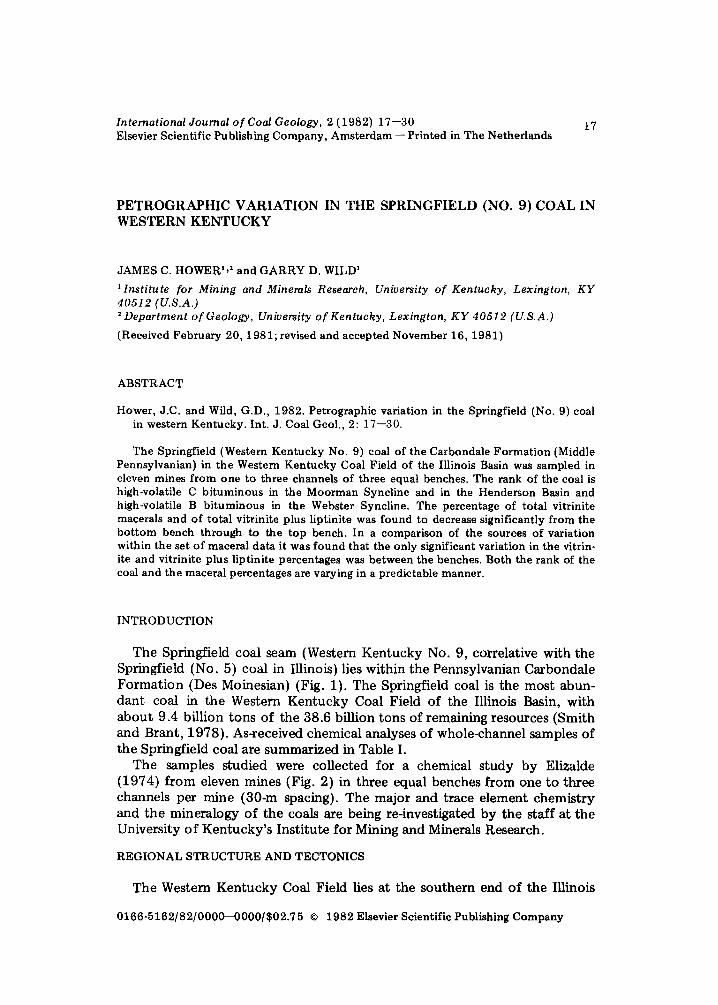
The Springfield coal seam (Western Kentucky No. 9, correlative with the Springfield (No. 5) coal in Illinois) lies within the Pennsylvanian Carbondale Formation (Des Moinesian) (Fig. 1). The Springfield coal is the most abun- dant coal in the Western Kentucky Coal Field of the Illinois Basin, with about 9.4 billion tons of the 38.6 billion tons of remaining resources (Smith and Brant, 1978). As-received chemical analyses of whole-channel samples of the Springfield coal are summarized in Table I.
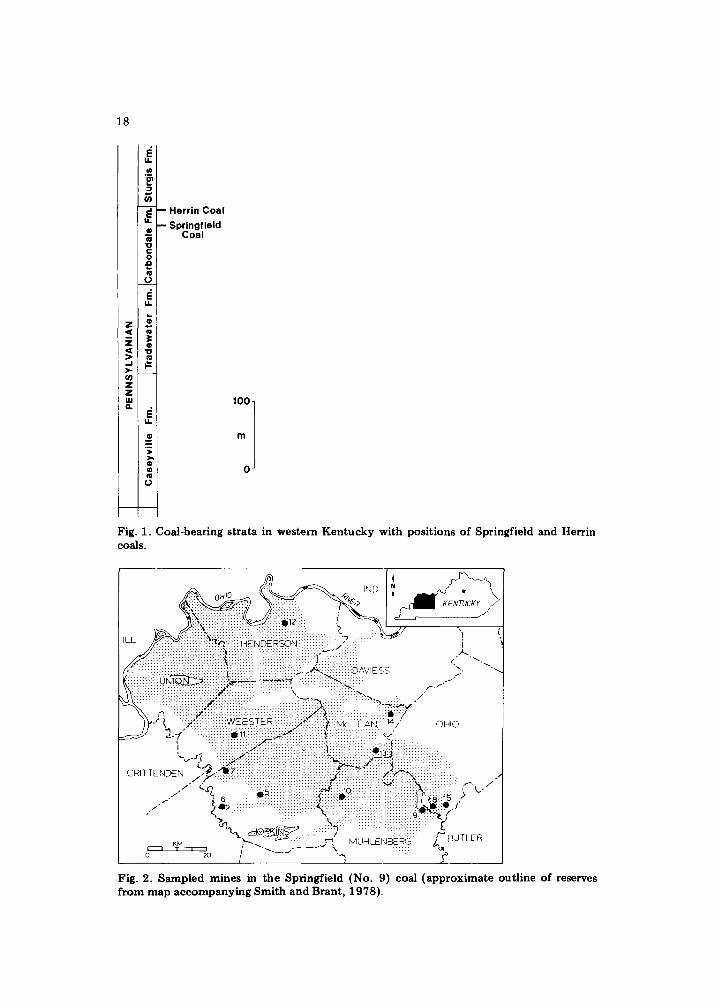
The samples studied were collected for a chemical study by Elizalde (1974) from eleven mines (Fig. 2) in three equal benches from one to three channels per mine (30-m spacing). The major and trace element chemistry and the mineralogy of the coals are being re-investigated by the staff at the University of Kentucky's Institute for Mining and Minerals Research.
REGIONAL STRUCTURE AND TECTONICS
The Western Kentucky Coal Field lies at the southern end of the Illinois
0166-5162/82/0000--0000/$02.75 © 1982 Elsevier Scientific Publishing Company
18
I&
P
F~ - - H e r r i n C o a l
u . - - S p r i n g f i e l d C o a l
-o t- o £
,3 IL
=.= < co
' ~ "o
>-
Z Z I.LI
u..
e >
o u~ ¢l
O
0 J
Fig. 1. Coal-bearing strata in western Kentucky with positions of Springfield and Herrin coals.
Ol4fO " " . .~ .~ ~
, ~ ~ - ~ J "!
. . . . . . . . . . . . . . . . . . . . . . . . . . . . . . . . . . . . . . . . . . . . . . . . . . . . . . . . . E < S < ~ " " ~ ' - ,
S iiiiiiiii::ilY:::iiiiiiii::iii::i::iiiii::i::~:iii.i.i.i::!il :!!:! .............. ,, .......... ::ii iii(~. / ' - ~ .., i i ~ .... ::::::::::::~::::: : : '~'~
- ' : : :~: : : : : : : : : : : W E B S T E R : : ' : ' : + : ' : ' : ' : " ~ ' : : : : : : : : : : . . : : : : " " ' " ' : " 14 ' [~ ~ .......................................................... : : : : : : :~ . . . . . . . . t : : B ~ -=E 'AI~ . / O H I O - - - J ~ -~ " ========================= :1: ::::: : : : : : ~ : ::7:::::::::::::" :::::::::::::::::::::::::::::: ~,'z'"
================================================================================================ : : : . :.. ~:::::::::::::: : .
'~...,~ .:ii~:/i::~i~i~i~i::ii~i~i::!~i::i::::::::::::::::::::::::::::::::::::::i~i~i~i~!::i::~::~!~ ~ ~3_~i~!!;:i:~i~::~ii~:i::ii:iii ....
• , " ' " ===================================== : : : : : : : : : :(. : : : : : : : ::: : :;::: :::::::::::::::::::::::::::::::::::::::::::::: I - ' - / / q , . . . . . . . . . . . . . . . . . . . . . . . . . . . . . . ~ . . . . . . . . . .
/ . .r" L .:~!:i:!:i:i:i:i:i:i:i:i:i:i:i:i:~,~:::.::i:i:~oi:i:i:i:::::!! iiiiiiiii~i:i:i:i::~:p .~ L. / " ~ 6 .:: :::::::::::::::::::::::::::::::::::::::::::::::::::::::::::::::::::::::::::::: : : : : : : : : : : : : : :~ i ~:.8 : i .k ° , / :~ ~ : : : : : : : : : : : : : : : : : : : : : : : : : : : : : : ::::~:!: : : . : : : : :::::::::::::::::::: : : : : : : : : : : : : : : : : : : : : : : : ~ . _ /
, " ~., ' " : ' ! : i : i : : : : : " \ " : : :i:i:i::!i!i!!i!!fiiiill i i # i i i i : ! : ! : ! : ! § ) . . . : . : ~ f "%~.~ ~ . ~ . ~ ......... ~::~ ........ ~:~:~::::::::: :::::::::::::::::::
~M ~ ' ~ . : : : : : : ' ~ M U H L E N E ~ R G . / B U T L E R
o " ' ~ / " ' " " . . . . . . . . . k"', ...... ! ! "~d'
Fig. 2. Sampled mines in the Springfield (No. 9) coal (approximate outline of reserves from map accompanying Smith and Brant, 1978).
TA
BL
E I
Spr
ingf
ield
(N
o. 9
) co
al:
pro
xim
ate
and
ult
imat
e an
aly
ses
by
co
un
ty (
as-r
ecei
ved
basi
s)
Co
un
ty
No.
M
ois
ture
A
sh
Vo
lati
le
Fix
ed
S C
H
S
amp
les
mat
ter
carb
on
N
BT
U
BT
U
(a.r
.)
(mm
mf)
Dav
iess
4
9.9
8
Hen
der
son
6
7.8
3
Ho
pk
ins
22
5.7
3
Mu
hle
nb
erg
10
6
.32
O
hio
20
6.
61
Un
ion
16
6.
77
Web
ster
12
2.
85
11
.33
3
5.9
5
42
.71
4.
21
61
.44
4
.44
0
.84
1
10
15
1
32
72
1
2.8
8
36
.60
4
2.6
6
4.07
6
3.0
6
4.61
1.
15
10
99
6
13
01
4
9.4
1
38
.25
4
6.3
8
3.48
6
6.4
5*
4
.68
*
1.0
8"
12
24
5
13
80
7
9.9
2
39
.26
4
4.5
0
3.35
6
6.7
9
4.7
0
1.11
1
19
55
1
36
29
9.
85
39
.62
4
3.9
3
3.6
9
67
.14
4
.83
1.
25
11
89
9
13
57
4
13
.34
3
6.3
6
43
.50
3.
87
61
.38
4.
27
1.04
1
14
16
1
33
54
1
0.5
2
38
.40
4
8.5
6
3.85
6
8.8
0
4.87
1.
11
12
77
2
13
98
6
"18
sam
ples
.
q~
2 0
IND
DAv,Es " ; . "-- "UN ON:::::-::- "~ . . . . . . . . ~" ..:::::i:~:~. / ~ "
\ .... :::: : :: :~ou~,~ . ::::::::::::::::::::::: ~ . . P" W e b s t e r " " " - . : + : : : : : : : : : : : : : : : : : : : : : : : : : : : : : : : : : : : : : : : : : : : : : : : : : : . . . . . . . "
sync,,no , / cP~'<:.t:~'.~,>~~i~m~:::: i : :~ ~ i ~ ~ ~ ~ i ~ ! ~ : : ~ : ~ : : ~ ~: ~ ~ ~ ~:~:i:~:~::~:~:i .......... / .~:i:!!: : : :::::::::::::::::::::::::: " ==================================================================
"')q'~- t' ~ / " WEBSTER ........... :::::::::::::::::::::::::::::::::::::::::: / OHIO :.:-~;~,t.:-:.:.:.:.: ::.:.:. .:.:.:.:.:.:.:- %, .'
~~ i : .... !i!!!iiiiiiiiii:i:i:!i!~i!iii? .... ~. J / " !:i:]:!:i:~ i ii!i:i:t ::: ::::::::::::::::::::::::::::::::::::::::::::::::::::::::: .......... . ~ / - - - ;
C RITTE NDE~::::I:::::::: ~ i : : : : : : : : i :: :: i i ~@~::~ 9~ ..... j ' ~ - - - - " / ! f " ,
/ " ~::~::i:'ii~ ............ MOO . . . . ¢ Syndine ~'} Y k / /
• ~ ................ i ............. P e n n )~ r i J e:iii~::i!~Joul;c: ~]i!:i ........................ C' : i~#: . * ~ : : : :~ i~ i . t N~ ............... ~ ........................... i:i:!~! i~!!!i:~:!:i ii~ii~!##~:i ...........
• ,,... ,.-1 MUH LENE-~:- R~ .... )"'"BUTLER
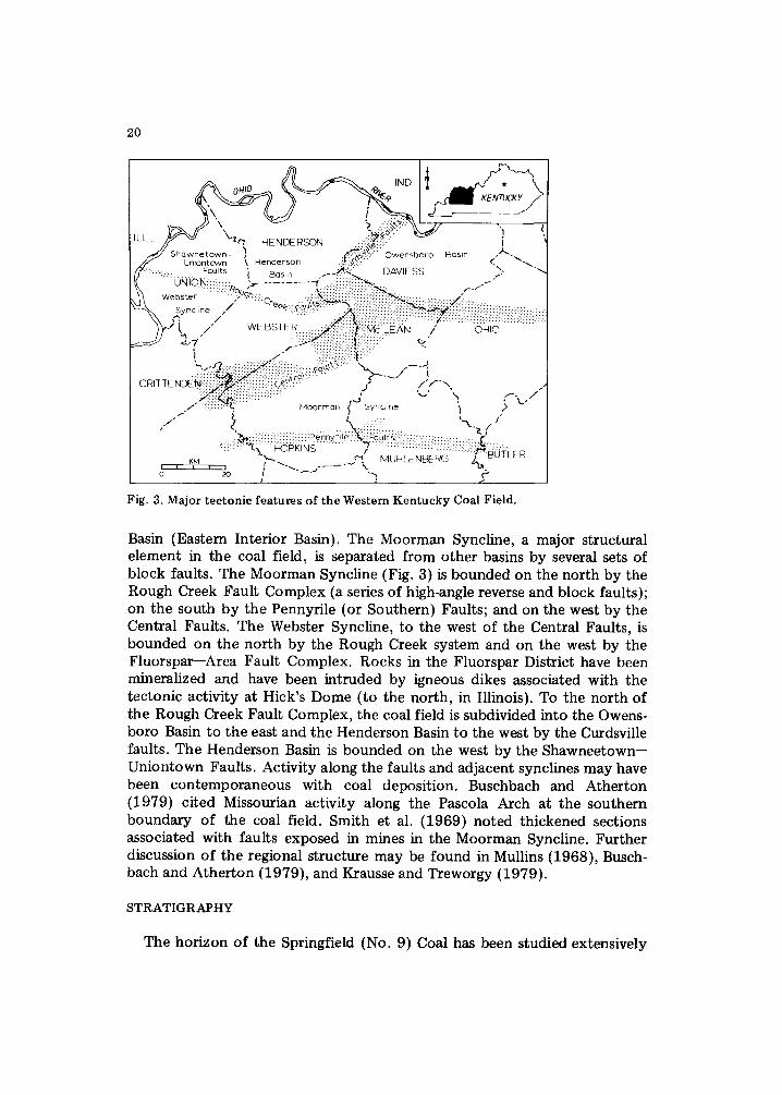
F i g . 3. M a j o r t e c t o n i c f e a t u r e s o f t h e W e s t e r n K e n t u c k y C o a l F i e l d .
Basin (Eastern Interior Basin). The Moorman Syncline, a major structural element in the coal field, is separated from other basins by several sets of block faults. The Moorman Syncline (Fig. 3) is bounded on the north by the Rough Creek Fault Complex (a series of high-angle reverse and block faults); on the south by the Pennyrile (or Southern) Faults; and on the west by the Central Faults. The Webster Syncline, to the west of the Central Faults, is bounded on the north by the Rough Creek system and on the west by the Fluorspar--Area Fault Complex. Rocks in the Fluorspar District have been mineralized and have been intruded by igneous dikes associated with the tectonic activity at Hick's Dome (to the north, in Illinois). To the north of the Rough Creek Fault Complex, the coal field is subdivided into the Owens- boro Basin to the east and the Henderson Basin to the west by the Curdsville faults. The Henderson Basin is bounded on the west by the Shawneetown-- Uniontown Faults. Activity along the faults and adjacent synclines may have been contemporaneous with coal deposition. Buschbach and Atherton (1979) cited Missourian activity along the Pascola Arch at the southern boundary of the coal field. Smith et al. (1969) noted thickened sections associated with faults exposed in mines in the Moorman Syncline. Further discussion of the regional structure may be found in Mullins (1968), Busch- bach and Atherton (1979), and Krausse and Treworgy {1979).
S T R A T I G R A P H Y
The horizon of the Springfield (No. 9) Coal has been studied extensively
21
in Kentucky and in Illinois and Indiana, where it is known as the Springfield (No. 5) coal. The Springfield coal, part of Pennsylvanian interval C (Upper Westphalian) of Wanless (1975), is a component of the St. David Cyclothem of Wanless and Wright (1978). The underlying strata were built by a com- posite delta system with one stream from the north and eight from the east (Wanless et al., 1969). The coal was deposited on a relatively flat surface (Wanless and Wright, 1978) and has a nearly continuous thickness and presence (Smith, 1967; Smith et al., 1969; Wanless and Wright, 1978) (about 1.5 m thick in Kentucky [Williamson and Beard, 1979; also, map accompa- nying Smith and Brant, 1978)]. The Coal is generally overlain by a marine black shale, followed by limestone or channel sands (Wanless and Wright, 1978; Gray, 1979; Ault et al., 1979). The marine sequence, although present, is suppressed in the Kentucky strata surrounding the Springfield (Williamson and Beard, 1979). The coal has been removed by post-deposi- tional channels in some places (Williamson and Beard, 1979), one of the most notable in Kentucky being the 35-km long north--south "Henderson Channel" (Beard and Williamson, 1979). This 0.5--1-km wide Sturgis Forma- tion channel eroded into and below the Mulford coal and can be seen in Henderson County on Fig. 2 as a north--south "no coal" zone.
The climate in the Illinois Basin at the time of deposition of the Spring- field coal was tropical-to-subtropical, with a more-varied climate than the Appalachian Basin (Schopf, 1979). Schopf (1975) placed the Carboniferous equator through the Appalachians, with Illinois to the north; while Habicht (1979), using paleomagnetic latitudes, placed the Illinois Basin closer to the equator than the Appalachian coal fields.
The plant community from which the coal developed was dominated by lycopods, with Psaronius and Medulosa being of secondary importance (Phillips, 1979). In Indiana, Marattialian tree ferns may have dominated over the lycopods (Ault et al., 1979). In a review of Pennsylvanian palynology, Phillips et al. (1974) noted the dominance of Lycospora species, with im- portant contributions from Marattialian species (Thymospora, Laevigatospo- rites, Torispora).
PREVIOUS PETROGRAPHIC RESEARCH
The Springfield coal is a bright coal with no continuous clay or shale partings (Smith et al., 1969). Ault et al. (1979) observed that the top portion of the seam is the dullest. Harvey et al. (1979) have reviewed the petrology of several Illinois Basin coals, among them, the Springfield. Dam- berger {1974) noted that the southern portion of the Illinois Basin has areas of anomalously high heat flow, possibly due to plutonic activity. Barrows et al. (1980) have shown similar areas of relatively high rank in their study of the organic petrography of the Devonian New Albany Shale. Previous studies in western Kentucky have shown that the highest rank coal (in the major mining area) is found in the Webster Syncline (known rank up to high vola- tile A bituminous with other basins having coal generally of high volatile C bituminous rank (Hower and Gong, 1980; Hower and Wild, 1981).

22
DISCUSSION
The maceral content of the samples and the vitrinite reflectance (maxi- mum reflectance; oil immersion at 546 nm) for each bench by mine is summarized on Table II. A total of 65 samples were available for study.
T A B L E II
Maceral c o n t e n t and v i t r in i te m a x i m u m ref lec tance (oil; 546 n m ) No. 9 coal by top, middle , b o t t o m th i rd o f seam by si te
Mine Vi t r in i t e Pseudo- Fus in i te - O t h e r L ip t in i tes Rmax bench v i t r in i te semifus in i te iner t s
5 T 79.0 1.6 12.4 3.2 3.9 0.57 5 M 84.0 3.5 7.3 2.1 3.1 0.57 5 B 87.5 2.1 6.5 1.8 2.2 0 .56
6 T 78.0 0.7 13.0 3.7 4.7 0 .55 6 M 84.2 2.7 8.3 2.4 2.6 0 .59 6 B 87.6 2.5 6.6 1.4 2.1 0.57
7 T 72.2 3.9 13.7 5.5 4.9 0 .63 7 M 81.3 5.9 9.3 1.4 2.2 0 .62 7 B 88.1 4.0 4.2 1.3 2.6 0 .66
8 T 75.8 2.2 12.1 6.0 3.9 0 .57 8 M 83.2 2.5 9.1 2.2 3.0 0 .52 8 B 89.6 1.6 5.3 1.5 2.0 0 .53
9 T 78.0 2.6 11.6 3.4 4.6 0 .56 9 M 87.5 2.4 5.6 1.8 2.9 0 .56 9 B 86.7 2.0 7 .0 1.7 2.7 0.51
10 T 76.2 2.4 14.2 2.9 4.3 0 .55 10 M 84.5 3.4 8.6 1.3 2.2 0.51 10 B 86.9 2.8 6.3 1.3 2.7 0.51
11 T 75.8 5.2 10.3 5.5 3.2 0.71 11 M 79.5 6.3 9.3 1.4 3.5 0 .69 11 B 83.1 6.6 5.8 2.6 1.9 0 .63
12 T 78.2 1.7 13.3 3.2 3.6 0 .49 12 M 77.7 1.8 13.3 2.9 4.3 0 .48 12 B 81.9 2.0 11.0 2.2 2.9 0 .47
13 T 70.3 2.1 14.1 6.9 6.6 0 .52 13 M 85.2 2.6 9.2 1.2 1.9 0 .52 13 B 87.1 2.3 5.2 2.2 3.2 0 .48
14 T 71.9 2.1 15.5 5.8 4.8 0 .45 14 M 79.2 1.4 13.4 2.5 3.5 0 .44 14 B 85.1 2.7 8.5 1.4 2.5 0 .45
15 T 76.4 2.0 10.0 6.1 5.6 0 .53 15 M 82.9 3.1 8.0 3.0 3.2 0.51 15 B 85.7 2.6 7.1 2.4 2.2 0.47
23
Mines 10, 11, and 13 were represented by single channels, and the bottom bench of the second channel in mine 15 was not retained from the chemical study. Mines 5, 8, and 12 were represented by three complete channels of three benches each. The remaining mines were represented by two complete channels. The unbalanced sample design imposed limitations upon the statis- tical analysis of the maceral percentages to be discussed below.
INE) o,,o . ~..e.~ "
| ( ~ < ~ I <i '"- : : :::::::.ii::iiiiii ........... i:iii!iiii::iiiiiiiiiii~!iiiiiiiiiiii iiiiii~iiiiiiiiii~-~:.::~::ii~ii::i::i!::i::i[~. ~ /
I ~ - -
: ' : : : : ' : : ' : : : ' : ' : - : ' : : : : : : : : : : : " - ~ - : : : : : : : : : : 1~ • . /
........ i:::iiii:iii~ ! i : !~ i i i? ! : ::i i : ................... :::::i:i:~.i::;::- " . . ~ " ,-', ............. ~ ................................................ : ......... ~ : : ~ ........ ~ ........... i:i:ar:::;;"
~ . , ~ ::::::::::::::::::::::::::::::::::::::::::::::::::::::::::::::::::::::::::::::::::: ,,,s o.~o :::::::::::::::::::::::::::::::::::::::::::::::::::::::::::::::::::::::::::::::::::::::::::::: :.'~.::: : :: :.
: : : : : : : : : : : : : : : : : : : : : : : : : : : : : : : : : : : : : : : : : : : : : : : : : : : : : : : : : : : : : : : : : : : : : : : : : : : : ' ~ . . r ' ~ : : : : : : : : : : : : : : : : : : : : : : : : : : : : : : : : : : : : : : : : : : : : : : : : : : : : : : : : : : : : : : : : : : : : : : : : : : : : : : : : : : : : : : : : : : : : ' ~ : ( ~,~: : : : : : : : ::: : : : : : : .
" ~ , : : " ~ " : . . . . . . ~ ' ~ . . . . . . : - : : . : x 6 : . : : : . : . : . : ' : 1 : : : : : : : : : : : : : : : : : : : : : : : : : : : : : : : : : : : : : : : : : : : : : : : : : : : : : : : : : : : : : : : : : : : : : : : : : : : : : : : : : : : : : : : : : : : : : : : : , : . : : : : : : : : : : : : : : ::: : : : R N . ~ " 7 4 1 ' " ' " " " " " " " ' " " ' " " ' " ' " ' " " ' " ' " ' " " " ' " " - " " " - ' ~ : " . . . . . . . . . .
C 1 T T E N D E . . v . ,:, ,,: 64: :,:,:,:.:,:.: :,:.:+: :,:,:.: :+:+: :.:,:.:,:,:,:;~ +:,:.! i,i, ,i,i,i.i?i:i:~:~::i:i:i:i::.~i$i:::!$!:i:::::: :::: . ,
'?n ...... . k : !~? :~: i{i~i!i iii:iiiiii ~i~ili i~::::::iiii::: r "~ 140 i~ :~ . . ~ ..:::::: . " . . . . . . . . . . ::::::::::::::::: ,....h
, \ , c u ~ ..:.::::::. / . . . . . . . . ~ ~ : ~ ; 4 : ; B U T L E R i l i i i - ~ 2 . . . . %
o = / . . . . 7 P
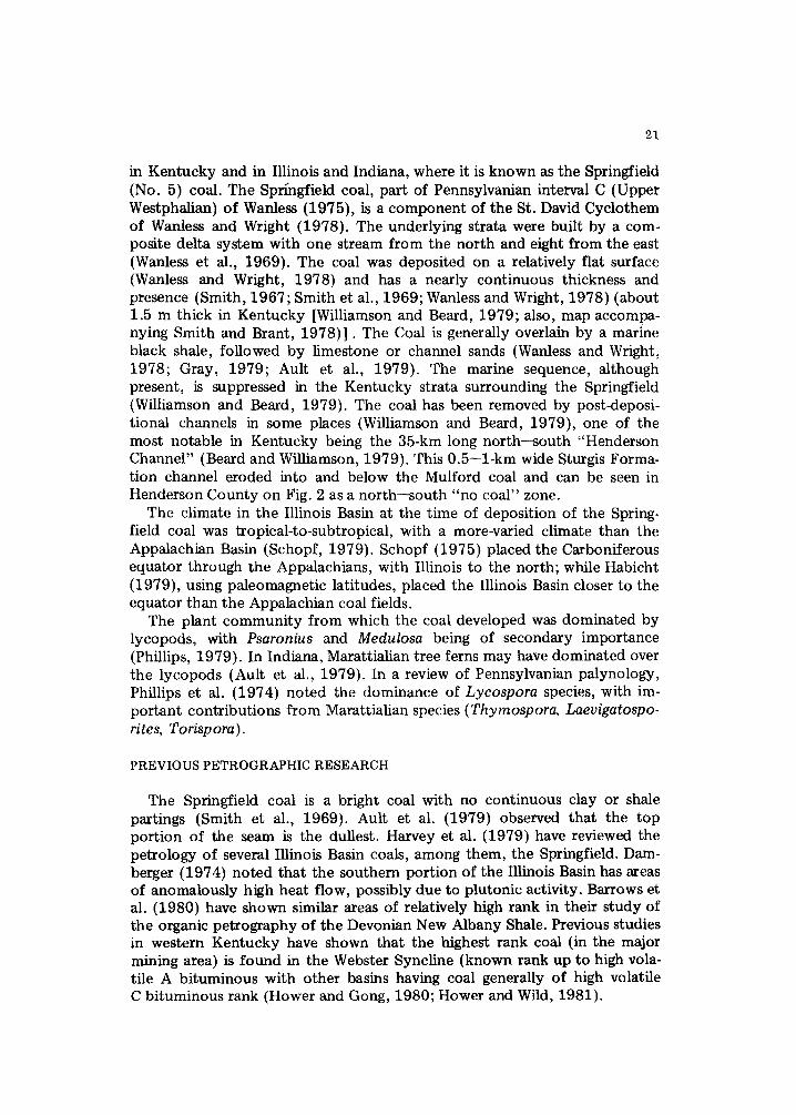
Fig. 4. Vitrinite maximum reflectance for the Springfield (No. 9) coal in western Ken- tucky.
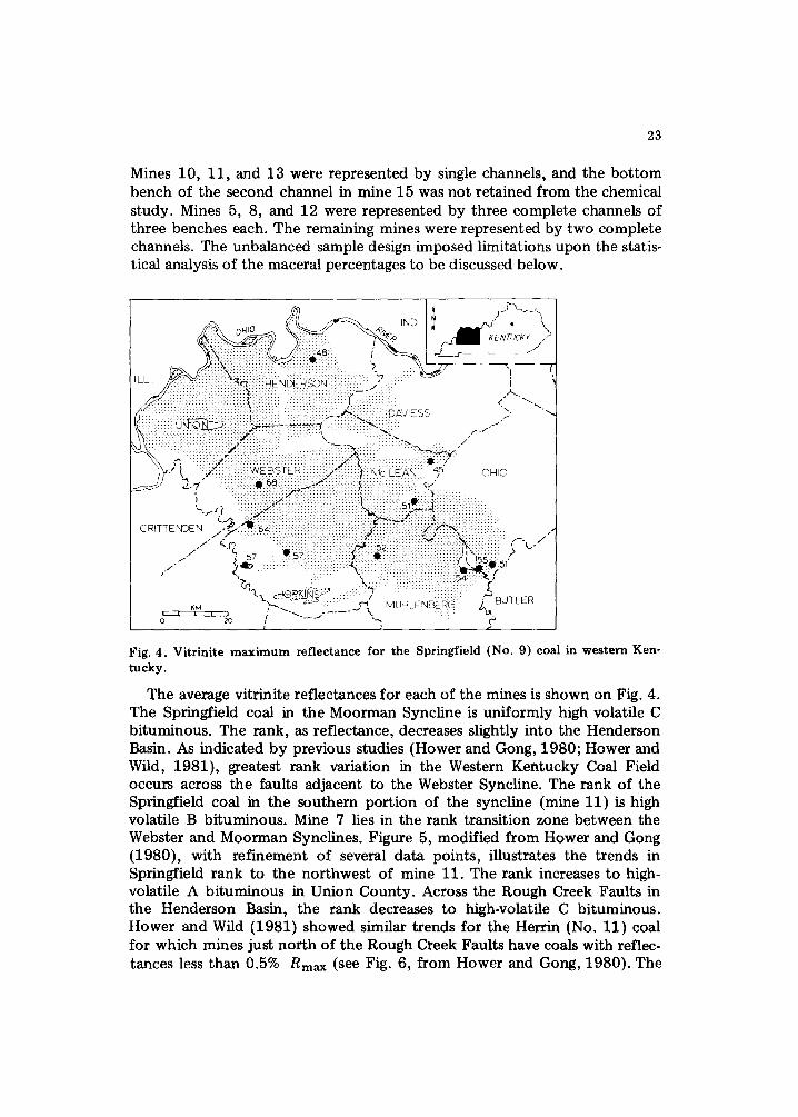
The average vitrinite reflectances for each of the mines is shown on Fig. 4. The Springfield coal in the Moorman Syncline is uniformly high volatile C bituminous. The rank, as reflectance, decreases slightly into the Henderson Basin. As indicated by previous studies (Hower and Gong, 1980; Hower and Wild, 1981), greatest rank variation in the Western Kentucky Coal Field occurs across the faults adjacent to the Webster Syncline. The rank of the Springfield coal in the southern portion of the syncline (mine 11) is high volatile B bituminous. Mine 7 lies in the rank transition zone between the Webster and Moorman Synclines. Figure 5, modified from Hower and Gong (1980), with refinement of several data points, illustrates the trends in Springfield rank to the northwest of mine 11. The rank increases to high- volatile A bituminous in Union County. Across the Rough Creek Faults in the Henderson Basin, the rank decreases to high-volatile C bituminous. Hower and Wild (1981} showed similar trends for the Herrin (No. 11) coal for which mines just north of the Rough Creek Faults have coals with reflec- tances less than 0.5% Rmax (see Fig. 6, from Hower and Gong, 1980). The
24
", ;5 ..48 i;,:,
~ -~-m--" 30
Fig. 5. Vitrinite maximum reflectance for the Springfield (No. 9) coal in the western portion of the Western Kentucky Coal Field (modified from Hower and Gong, 1980).
j • / / o . 4 7 "'" ' '-'
', . . . . . . ;; . . /7 .... ,,
,'L ,^=
Fig. 6. Vitrinite maximum reflectance for the Herrin (No. 11) coal in the western portion of the Western Kentucky Coal Field (modified from Hower and Gong, 1980).
25
/ // : SO h:il ! : i
/ / : " , " / [( ............. u ~ , ~ . ~ ~ ......... " ~ - ~ - ~ - ~ ............................... ~ . I
[ X ~ ' x : : ~ : : x : x . . . . . . . . . . . : ~ ::::: -
I '~,,}'-" ( ~ _ E , , ~ t ' i : /808 , ~ H I C
C R I T T E N ~ , E i ' 4 , , . / : : : : :: :: :: : : : : : : : : : : : : : : :: : : : : : : : :::: ::: / . . - . . . . . . . . . . . . . . . . . . . . . . . . . . . . .
/ . - ,f~ : : : : : 8 5 9 : ',, k,.- . i 853 ~ \ ~ c J : ,"
• '~ 410 : : ~ Q : : : ~ f / ~ . . . . . . . . . . . . . . . . - , , : . v : ,
~,M ~ ~ * - ,'-1 M U H L E N E ~ E R G ] . . . . . . .
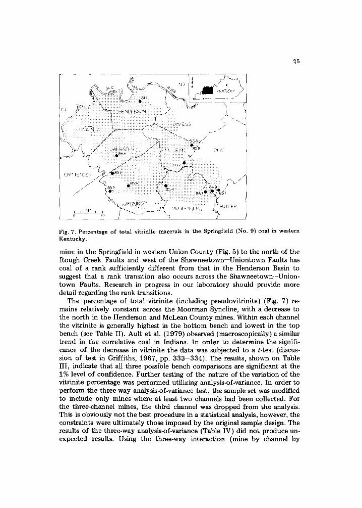
Fig. 7. P e r c e n t a g e o f t o t a l v i t r in i t e mace ra l s in t h e S p r i n g f i e l d (No . 9) coa l in w e s t e r n K e n t u c k y .
mine in the Springfield in western Union County (Fig. 5) to the north of the Rough Creek Faults and west of the Shawneetown--Uniontown Faults has coal of a rank sufficiently different from that in the Henderson Basin to suggest that a rank transition also occurs across the Shawneetown--Union- town Faults. Research in progress in our laboratory should provide more detail regarding the rank transitions.
The percentage of total vitrinite {including pseudovitrinite) {Fig. 7) re- mains relatively constant across the Moorman Syncline, with a decrease to the north in the Henderson and McLean County mines. Within each channel the vitrinite is generally highest in the b o t t o m bench and lowest in the top bench (see Table II). Ault et al. (1979) observed (macroscopically) a similar trend in the correlative coal in Indiana. In order to determine the signifi- cance of the decrease in vitrinite the data was subjected to a t-test {discus- sion of test in Griffiths, 1967, pp. 333--334). The results, shown on Table HI, indicate that all three possible bench comparisons are significant at the 1% level of confidence. Further testing of the nature of the variation of the vitrinite percentage was performed utilizing analysis-of-variance. In order to perform the three-way analysis-of-variance test, the sample set was modified to include only mines where at least two channels had been collected. For the three-channel mines, the third channel was dropped from the analysis. This is obviously no t the best procedure in a statistical analysis, however, the constraints were ultimately those imposed by the original sample design. The results of the three-way analysis-of-variance {Table IV) did not produce un- expected results. Using the three-way interaction (mine by channel by
26
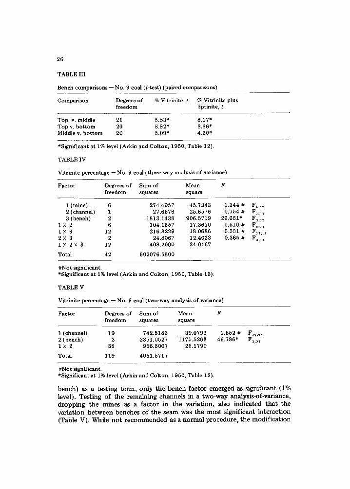
TABLE III
Bench c o m p a r i s o n s - No. 9 coal (t-test) (paired comparisons)
Comparison Degrees of % Vitrinite, t % Vitrinite plus freedom liptinite, t
Top. v. middle 21 5.83* 6.17" Top v. bo t tom 20 8.82* 8.86* Middle v. bo t tom 20 5.09* 4.60*
*Significant at 1% level (Arkin and Colton, 1950, Table 12).
TABLE IV
Vitrinite percentage -- No. 9 coal (three-way analysis of variance)
Factor Degrees of Sum of Mean F freedom squares square
l ( m i n e ) 6 274.4057 45.7343 2(channel) 1 27.6576 25.6576 3(bench) 2 1813.1438 906.5719
1 × 2 6 104.1657 17.3610 1 × 3 12 216.8229 18.0686 2 × 3 2 24.8067 12.4033 1 X 2 × 3 12 408.2000 34.0167
Total 42 602076.5800
1.344 # 0.754 #
26.651" 0.510 # 0.531 # 0.365 #
F,,12 F1,~2 F2,12 F,,12
F2,12
#Not significant. *Significant at 1% level (Arkin and Colton, 1950, Table 13).
TABLE V
Vitrinite percentage -- No. 9 coal (two-way analysis of variance)
Factor Degrees of Sum of Mean F freedom squares square
l ( channe l ) 19 742.5183 39.0799 1.552 # F~9,28 2(bench) 2 2351.0527 1175.5263 46.786* F2,3s 1 × 2 38 956.8007 25.1790
Total 119 4051.5717
#Not significant. *Significant at 1% level (Arkin and Colton, 1950, Table 13).
b e n c h ) as a t e s t i n g t e r m , o n l y t h e b e n c h f a c t o r e m e r g e d as s i g n i f i c a n t (1% leve l ) . T e s t i n g o f t h e r e m a i n i n g c h a n n e l s in a t w o - w a y a n a l y s i s - o f - v a r i a n c e , d r o p p i n g t h e m i n e s as a f a c t o r in t h e v a r i a t i o n , a l so i n d i c a t e d t h a t t h e v a r i a t i o n b e t w e e n b e n c h e s o f t h e s e a m w a s t h e m o s t s i g n i f i c a n t i n t e r a c t i o n ( T a b l e V) . W h i l e n o t r e c o m m e n d e d as a n o r m a l p r o c e d u r e , t h e m o d i f i c a t i o n
LL "! ....................... :::::::::::::::::::::::::::::::: :::::::::::::::::::::::::::::
/ / i i i ii ii < / /~C : : : : : : : : : : : : : : : : : : : : : : ~ ! ~ i : : ~ : i : i :::::::ii~:::i~:
27
I f l~ - .
.... " ,,~'< :: :':: : : : :DAVE SS \ :: : : : u t 4 ~ i i i : : i ~ + ~ - ~ i ~ : ~ , ~ :i :::::i::::?~:_ ....... f "
....... : ~ i ~ i ~ " . . . . . . Ill::::/
====:====:=====:===S==E ... . . . . . ~ ~ . . : , c -hE, 84 7 ~ H
; ..... <')i ......
CR TTENDEN . ~ "'7:" . . . . . . . . . . . . . . . . . . . . . . ) . . . . . . . . . . . . . . . . ~ .................. ' / / " ========================================= : : : : : : : : : : : : : : : : : : : : : : : : : : : : : : : : : : : : : : : : : : : : : : : : : :
/ '-t I i . , "':::i i i i i: i:i i::i;i ii !!i!i!i~iiiiii:iiii:iiii:iiii: iiiii;~iii:ii :iii~iii:iiiiil F ' - ' t . . / / " "/,., : : : : : : : : : : : : : : : : : : : : : : : : : : : : : : : : : : : : : : : : : : : : : : : : : : : : : : : : : : : : : : : : : : : : : : : : ~ "
i i 8 8 4 :. :: : : : : : : : : : : : : : : : : : : : : : : : : : : : : : : [ : : : : [ : : : : : : : : : : : : : : : : : : : : : : : : : : : : : ( 1 f379::: : : , " • ~ " : : : : : : : : : . . . . . . . . . . . . . . . . . . ~ < < 0 /
- " Z ........ : ................. ~ ..... :::::::::::::::::::::::::::::::::::::::::::: / ~ : ' ~ ::::: ================================= 7.::::::: ::~-, i
KM " l . \ . ~ ~ . . . . . ............. /~i\ MUHLENBEI~G .... ~ ; - BUTLER
i - - - . . . . ..........
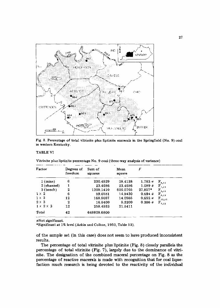
Fig. 8. Percentage of total vitrinite plus liptinite macerals in the Springfield (No. 9) coal in western Kentucky.
TABLE VI
Vitrinite plus liptinite percentage No. 9 coal (three-way analysis of variance)
Factor Degrees of Sum of Mean F freedom squares square
1 (mine) 6 230.4829 38.4138 1.783 # F,,12 2 (channel) 1 23.4686 23.4686 1.089 # F1,~2 3 (bench) 2 1200.1410 600.0705 27.857* F~,12
1 x 2 6 89.6581 14.9430 0.694 # F~,~ 1 x 3 12 168.6057 14.0505 0.652 # F12,~ 2 2 x 3 2 16.6400 8.3200 0.386 # F2,~2 1× 2X 3 12 258.4933 21.5411
Total 42 648828.6800
#Not significant. *Significant at 1% level (Arkin and Colton, 1950, Table 13).
of the sample set (in this case) does not seem to have produced inconsistent results.
The percentage of total vitrinite plus liptinite (Fig. 8) closely parallels the percentage of total vitrinite (Fig. 7), largely due to the dominance of vitri- nite. The designation of the combined maceral percentage on Fig. 8 as the percentage of reactive macerals is made with recognition that for coal lique- faction much research is being devoted to the reactivity of the individual
28
macerals, some of which are not fully understood (Yarzab et al., 1980; Given et al., 1980). The lowest percentages occur in the same mines which had the lowest vitrinite percentages. The dominance of the vitrinite in the total percentage is also shown in the t-test {Table III) and in the three-way analysis-of-variance (Table VI; subject to the same constraints discussed above). The most significant variation occurs between the benches of the seam. Examination of the data in Table II shows, however, that the liptinite percentage is actually varying inversely to the vitrinite percentage (the inerts are also varying inversely to vitrinite).
SUMMARY
The geologic significance of the trend of bench variation cannot be fully assessed at this point. In our study of the Herrin (No. 11) coal (Hower and Wild, 1981), a similar between-bench variation was observed to correlate with apparent changes in the plant community. Work by Charles Helfrich of Eastern Kentucky University (pets. commun., 1980) demonstrated that the observed lower vitrinite percentage in one bench of a Webster County mine corresponded to a loss of lycopod palynomorphs in favor of monolete species. Corresponding data from the Springfield coal is not currently avail- able, but the increase in fusinite and semi-fusinite in the top bench relative to the middle and bottom benches suggests that the environment became drier in the later stages of peat accumulation. The relative lack of between- mine variation in the maceral content of the Springfield coal compared to the between-bench variation is significant in projecting the nature of the coal in areas where mining is not currently practiced. The rank of the coal varies, but as mentioned, does vary in a predictable manner across the major faults, particularly the faults flanking the Webster Syncline.
ACKNOWLEDGEMENTS
The samples were collected by Leonardo Elizalde and other geologists with the Kentucky Geological Survey and the Institute for Mining and Minerals Research. The samples were retained by Alan Bland (IMMR) and were prepared by Beth Estes (IMMR). Chemical analyses were performed in IMMR laboratories under supervision of David W. Koppenaal. We wish to acknowledge constructive criticism from the geologists who visited our poster session at the 1980 Geological Society of America convention in At- lanta.
REFERENCES
Arkin, H. and Colton, R.R., 1950. Tables for Statisticians (1963 edition). Barnes and Noble, New York, N.Y., 168 pp.
29
Ault, C.H., Cart, D.D., Chen, P.Y., Eggert, D.L., HassenmueIler, W.A. and Hutchinson, H.C., 1979. Geology of the Springfield Coal Member (V) in Indiana -- a review. In: J.E. Palmer and R.R. Dutcher (Editors), Depositional and Structural History of the Pennsylvanian System of the Illinois Basin. Part 2: Invited papers. Field trip 9, Ninth Int. Congr. of Carboniferous Stratigraphy and Geology, May 26--June 1, 1979, Urbana, Ill., pp. 43--49.
Barrows, M.H., Cluff, R.M. and Harvey, R.D., 1980. Organic petrography. In: R.E. Berg- strom and N.F. Shimp (Principal Investigators), Geologic and Geochemical Studies of the New Albany Shale Group (Devonian--Mississippian) in Illinois. Final Rep. to U.S. Dep. Energy, Ill. State Geol. Surv., pp. 63--75.
Beard, J.G. and Williamson, A.D., 1979. A Pennsylvanian channel in Henderson and Webster Counties, Kentucky. Ky. Geol. Surv., Ser. XI, Inf. Circ. I, 12 pp.
Buschbach, T.C. and Atherton, E., 1979. History of the structural uplift of the southern margin of the Illinois Basin. In: J.E. Palmer and R.R. Dutcher (Editors), Depositional and Structural History of the Pennsylvanian System of the Illinois Basin. Part 2: In- vited papers. Field trip 9, Ninth Int. Congr. of Carboniferous Stratigraphy and Geology, May 26--June 1, 1979, Urbana, Ill., pp. 112--115.
Damberger, H.H., 1974. Coalification patterns of Pennsylvanian coal basins of the eastern United States. In: R.R. Dutcher and others (Editors), Carbonaceous Materials as Indi- cators of Metamorphism. Geol. Soc. Am. Spec. Pap., 153: 53--74.
Elizalde, L., 1974. Analysis of Element Distribution in the No. 9 Coal Seam of the Eastern Interior Coal Field of Western Kentucky. M.S. Thesis, Univ. Kentucky, Lexington, 133 pp.
Given, P.H., Spackman, W., Davis, A. and Jenkins, R.G., 1980. Some proved and unprov- ed effects of coal geochemistry on liquefaction behavior with emphasis on U.S. coals. In: D.D. Whitehurst (Editor), Coal Liquefaction Fundamentals. Am. Chem. Soc., Symp. Ser., 139: 3--34.
Gray, H.H., 1979. The Mississippian and Pennsylvanian (Carboniferous) Systems in the United States- Indiana. U.S. Geol. Surv. Prof. Pap. 1110-K, 20 pp.
Griffiths, J.C., 1967. Scientific Method in the Analysis of Sediments. McGraw-Hill, New York, N.Y., 508 pp.
Habicht, J.K.A., 1979. Paleoclimate, paleomagnetism, and continental drift. Am. Assoc. Pet. Geol., Studies in Geology, no. 9, 31 pp.
Harvey, R.D., Crelling, J.C., Dutcher, R.R. and Schleicher, J.A., 1979. Petrology and related chemistry of coals in the Illinois Basin. In: J.E. Palmer and R.R. Dutcher (Edi- tors), Depositional and Structural History of the Pennsylvanian System of the Illinois Basin. Part 2: Invited papers. Field trip 9, Ninth Int. Congr. of Carboniferous Strati- graphy and Geology, May 26--June 1, 1979, Urbana, Ill., pp. 127--142.
Hower, J.C. and Gong, Z., 1980. Coal rank in a port ion of the Western Kentucky coal field (abstr.). Bull. Am. Assoc. Pet. Geol., 64: 1285.
Hower, J.C. and Wild, G.D., 1981. Petrography of the Herrin (No. 11) coal in western Kentucky. Int. J. Coal Geol., 1: 139--153.
Krausse, H.F. and Treworgy, C.C., 1979. Major structures of the southern part of the Illinois Basin. In: J.E. Palmer and R.R. Dutcher (Editors), Depositional and Structural History of the Pennsylvanian System of the Illinois Basin. Part 2: Invited papers. Field trip 9, Ninth Int. Congr. of Carboniferous Stratigraphy and Geology, May 26--June 1, 1979, Urbana, Ill., pp. 115--120.
Mullins, A.T., 1968. Pennsylvanian structure of western Kentucky. In: W.D. Rose (Edi- tor), Proceedings of the Technical Sessions: Kentucky Oil and Gas Association, 30th and 31st Annu. Meet., 1966 and 1967. Ky. Geol. Surv., Ser. X, Spec. Publ., 15: 81-- 86.
Phillips, T.L., 1979. Paleobotanical studies in the Pennsylvanian System of the Illinois Basin. In: J.E. Palmer and R.R. Dutcher (Editors), Depositional and Structural History of the Pennsylvanian System of the Illinois Basin. Part 2: Invited papers. Field trip 9, Ninth Int. Congr. of Carboniferous Stratigraphy and Geology, May 26--June 1, 1979, Urbana, Ill., pp. 4--7.

30
Phillips, T.L., Peppers, R.A., Avcin, M.J. and Laughnan, P.F., 1974. Fossil plants and coal: patterns of change in Pennsylvanian coal swamps of the Illinois Basin. Science, 184: 1367--1469.
Schopf, J.M., 1975. Pennsylvanian climate in the United States. In: E.D. McKee and E.J. Crosby (Coordinators), Paleotectonic Investigations of the Pennsylvanian System, Part II. Interpretive Summary and Special Features of the Pennsylvanian System. U.S. Geol. Surv., Prof. Pap., 853: 23--31.
Schopf, J.M., 1979. Pennsylvanian paleoclimate of the Illinois Basin. In: J.E. Palmer and R.R. Dutcher (Editors), Depositional and Structural History of the Pennsylvanian Sys- tem of the Illinois Basin. Part 2: Invited papers. Field trip 9, Ninth Int. Congr. of Carboniferous Stratigraphy and Geology, May 26--June 1, 1979, Urbana, Ill., pp. 1--3.
Smith, G.E., 1967. Pennsylvanian cross sections in western Kentucky. Coals of the Lower Carbondale Formation, Part 1. Ky. Geol. Surv., Ser. X, Rep. Invest. 6, 14 pp.
Smith, G.E. and Brant, R.A., 1978. Western Kentucky coal resources. Ky. Geol. Surv./ Inst. Mining and Minerals Research, Energy Resources Series, 1,132 pp.
Smith, G.E., Williamson, A.D., Ponsetto, L.R., Franklin, G.J. and Palmer, J.E., 1969. Middle and Upper Pennsylvanian strata in Hopkins and Webster Counties, Kentucky. Geol. Soc. Ky., Spring Field Conference, April 25--26, 1969, Ky. Geol. Surv., Guide- book, 80 pp.
Wanless, H.R., 1975. Illinois Basin region. In: E.D. McKee and E.J. Crosby (Coordina- tors), Paleotectonic Investigations of the Pennsylvanian System in the United States, Part I. Introduction and Regional Analyses of the Pennsylvanian System. U.S. Geol. Surv., Prof. Pap., 853: 71--95.
Wanless, H.R. and Wright, C.R., 1978. Paleoenvironmental maps of Pennsylvanian rocks, Illinois Basin and northern midcontinent region. Geol. Soc. Am., Map/Chart Set. 23, 32 pp./165 figs.
Wanless, H.R., Barofio, J.R. and Treseott, P.C., 1969. Conditions of deposition of Penn- sylvanian coal beds. In: E.C. Dapples and M.E. Hopkins (Editors), Environments of Coal Deposition. Geol. Soc. Am., Spec. Pap., 114: 105--142.
Williamson, A.D. and Beard, J.G., 1979. Road log second day of field trip. In: P.W. Whaley and others (Editors), Depositional Environments of Pennsylvanian Rocks in Western Kentucky. Annu. Field Conf. Geol. Soc. Ky., October 11--13, 1979, Ky. Geol. Surv., Guidebook, pp. 26--39.
Yarzab, R.F., Given, P.H., Spackman, W. and Davis, A., 1980. Dependence of coal lique- faction behavior on coal characteristics. 4. Cluster analyses for characteristics of 104 coals. Fuel, 59: 81--92.