Embed Size (px)
Citation preview

PGHU-EH-SPZZZ-490013 June 2012 Rev. 0
Esso Highlands Limited
Papua New Guinea LNG Project
Campsite Area (KP 4.5) Communal Resource Plan
PGHU-EH-SPZZZ-490013
PAPUA NEW GUINEA KP 4.5 Campsite CRP LNG Project Page i of 21
PGHU-EH-SPZZZ-490013 June 2012 Rev. 0
CONTENTS
EXECUTIVE SUMMARY ...................................................................................................... 4
1.0 INTRODUCTION ........................................................................................................ 7
1.2 Resettlement Goal ................................................................................................. 9
1.3 Sources of Information and Compliance Protocols ................................................ 9
1.4 Project Description .............................................................................................. 10
1.4.1 Construction .................................................................................................... 10
1.4.1.1 Quarries / Borrow Areas ........................................................................... 10
1.4.1.2 Construction near Waterways .................................................................. 10
2.0 INSTITUTIONAL AND LEGAL FRAMEWORK ......................................................... 12
2.1 Minimizing Resettlement ..................................................................................... 12
3.0 SOCIAL, ECONOMIC AND CULTURAL ENVIRONMENT ....................................................... 12
3.1 Introduction to the Area .................................................................................... 12
3.2 KP4.5 Clans ........................................................................................................ 13
3.3 Types of Land Rights and Land Ownership ......................................................... 15
3.4 IPCAs and Project Socio-Cultural Context ........................................................... 15
3.4.1 Land Requirements ........................................................................................ 15 3.4.1.1 Land Needs.............................................................................................. 15
3.5 Cultural Heritage and Archaeological Sites .......................................................... 15
3.6 Social Sites .......................................................................................................... 15
4.0 CONSULTATION AND DISCLOSURE ..................................................................... 17
4.1 Stakeholder Engagement .................................................................................... 17
5.0 PROJECT IMPACTS ................................................................................................ 19
5.1 Cumulative Impacts ............................................................................................. 19
6.0 ELIGIBILITY AND ENTITLEMENTS ......................................................................... 20
7.0 LIVELIHOOD RESTORATION PROGRAM .............................................................. 20
8.0 GRIEVANCE MANAGEMENT FRAMEWORK.......................................................... 20
9.0 ORGANIZATIONAL ROLES AND RESPONSIBILITIES ........................................... 20
10.0 MONITORING AND EVALUATION .......................................................................... 20
11.0 IMPLEMENTATION SCHEDULE ............................................................................. 21
12.0 COST AND BUDGET ESTIMATE ............................................................................ 21

PAPUA NEW GUINEA KP 4.5 Campsite CRP LNG Project Page ii of 21
PGHU-EH-SPZZZ-490013 June 2012 Rev. 0
FIGURES
Figure 1-1: KP 4.5 Campsite Area locality map ..................................................................... 8
Figure 1-2: Proposed Plan of the campsite ......................................................................... 11
Figure 3-1: Hides-Komo Project Clan Map and Infrastructure Sites ..................................... 13
Figure 3-2: SMLI Map of Dimalia-Tagari River Area (Goldman 2001) ................................. 14
Figure 3-3: KP 4.5 Social Sites ........................................................................................... 16
TABLES
Table 1-1: Key Compliance Documents and Information Sources ........................................ 9
Table 3-1: Campsite CRP KP4.5 Clan List .......................................................................... 14
Table 3-2: KP 4.5 Social Sites ............................................................................................ 15
Table 4-1: KP 4.5 Public Disclosure Meeting ...................................................................... 17
Table 4-2: Summary of KP4.5 Campsite Public Consultation .............................................. 17
Table 5-1: Principal Impacts likely to be experienced by KP 4.5 Campsite Landowners ...... 19
Table 11-1: CRP Implementation Schedule ........................................................................ 21

PAPUA NEW GUINEA KP 4.5 Campsite CRP LNG Project Page iii of 21
PGHU-EH-SPZZZ-490013 June 2012 Rev. 0
ACRONYMS
Acronym Definition
BSA Benefit Sharing Agreement
CRP Communal Resource Plan
EHL Esso Highlands Limited
EIS Environmental Impact Statement
ELC Environmental Law Centre
FEED Front End Engineering Design
FRV Full Replacement Value
HGCP Hides Gas Conditioning Plant
HGDC Hides Gas Development Company
IFC International Finance Corporation
ILG Incorporated Land Group
IPCA In-Principle Compensation Agreement
KP Kilometer Point
Lanco Landowner Company
LBBSA License-Based Benefit Sharing Agreement
LNG Liquefied Natural Gas
M&E Monitoring and Evaluation
O&GA Oil and Gas Act
OSL Oil Search Limited
PNG Papua New Guinea
PNG LNG Papua New Guinea Liquefied Natural Gas Project
PS Performance Standard
RAP Resettlement Action Plan
RIT Resettlement Implementation Team
ROW Right of Way
RPF Resettlement Policy Framework
SIA Social Impact Assessment
SMLI Social Mapping and Landowner Identification
UBSA Umbrella Benefits Sharing Agreement
VG Papua New Guinea Valuer General

PAPUA NEW GUINEA KP 4.5 Campsite CRP LNG Project Page 4 of 21
PGHU-EH-SPZZZ-490013 June 2012 Rev. 0
EXECUTIVE SUMMARY
Introduction
Esso Highlands Limited proposes to develop the Papua New Guinea Liquefied Natural Gas Project to commercialize gas reserves within the PNG Southern Highlands and Western Provinces. An onshore gas pipeline and liquid condensate pipeline are required as part of the upstream infrastructure development for the Project.
A construction campsite area is required adjacent to KP 4.5 on the ROW. The Campsite Area is required for 12 months for logistical support, temporary 1000 worker accommodation, a mobile waste management facility, mechanic yard and storage of construction equipment. An access road will connect the KP 4.5 Campsite to the existing Hides to Komo Road, which lies approximately 80 m south of the border of the KP 4.5 Campsite construction footprint.
Scope
This CRP, referred to as the KP 4.5 Campsite Area CRP, focuses on economic displacement as a consequence of loss of forest resources. There is no physical displacement involved. The Campsite construction footprint abuts the ROW and covers an area of approximately 12 ha.
Resettlement Goal
The Project’s overall resettlement goal is to design and implement resettlement in a manner that improves or at least restores, livelihoods and standards of living of physically and economically displaced persons. The protocols defined in this CRP will be applied should any gardens and/or structures be identified during the construction period.
Institutional and Legal Framework
The resettlement process complies with legal requirements and criteria detailed in the RPF and previous CRPs.
Social, Economic and Cultural Environment
The following linguo-cultural group occupies areas in and around the projected KP4.5 Campsite:
• The Huli (150,000) who inhabit the areas north-west from Yalenda through Baguale-Homa-Paua-Yarale-Tari-Koroba and the area on the western side of the Hegegio/Tagari River from South Komo through to Nogoli-Yaluba-Mogora Pugua-Levani and Tanggi.
• The KP4.5 site is owned by the Tagobali (sub-clan:Walo) clan.
Consultation and Disclosure
All clans have signed the IPCA1 and participated in the formal disclosure meeting. Clan representatives assisted with the surveys of the Campsite Area and were supportive of the development. A process of disclosure of documents is in place and will include public dissemination and distribution of the KP 4.5 Campsite CRP in Huli and Pidgin as well as English.
1 Signed on 13th December 2011.

PAPUA NEW GUINEA KP 4.5 Campsite CRP LNG Project Page 5 of 21
PGHU-EH-SPZZZ-490013 June 2012 Rev. 0
Project Impacts
The Campsite Area developments are expected to result in the following impacts and associated mitigation measures:
• Approximately 12.0 ha of communal forest land. Compensation will be paid according to IPCA negotiated rates. No physical resettlement is expected and no gardens are affected.
• No businesses or employment are lost because of the Project.
• No cultural heritage sites were identified on the campsite area;
• There will be some further loss of land belonging to the Tagobali clan which have also been affected at the TB1 quarry site that lies adjacent to KP4.5 on the southern banks of the Dimalia River. Close monitoring of land shortage conditions will be undertaken.
• Influx of migrants to the site is unlikely due to both the short duration of site use and lack of any direct associated employment.
The site will be used for 12 months during construction and will be rehabilitated thereafter, in accordance with the environmental management plans and in consultation with landowners.
Eligibility and Entitlements
Landowners will be entitled to once off and rental payments for damage and deprivation, including loss of access to traditional hunting grounds. This will be paid out through clan representatives as per the IPCA agreement.
Livelihood Restoration Program
No loss of livelihoods is expected; however, in the event that livelihoods are impacted, the Project will ensure it implements livelihoods restoration in accordance with IFC PS 5 and the RPF.
Grievance Management Framework
A Project Grievance Mechanism has been implemented to receive, respond to, and address any grievances made to the Project.
Organizational Roles and Responsibilities
Overall responsibility for the planning, implementation and monitoring of economic displacement rests with the Company as specified in the RPF. The Company’s Land & Community Affairs Team will undertake these activities.
Monitoring and Evaluation
In the event that individual economic or physical resettlement does occur, Monitoring and Evaluation will provide information on whether individual compensation and resettlement activities are providing positive benefits, and will indicate the need for corrective action that may be required to achieve Project resettlement goals.
Implementation Schedule
A schedule of tasks has been developed to plan and implement the major components of the CRP’s implementation through to 2012.

PAPUA NEW GUINEA KP 4.5 Campsite CRP LNG Project Page 6 of 21
PGHU-EH-SPZZZ-490013 June 2012 Rev. 0
Cost and Budget Estimate
The cost of the KP 4.5 Campsite Area is estimated at approximately US$ 0.1 million, including IPCA clan payments.

PAPUA NEW GUINEA KP 4.5 Campsite CRP LNG Project Page 7 of 21
PGHU-EH-SPZZZ-490013 June 2012 Rev. 0
1.0 INTRODUCTION
1.1 Background
Esso Highlands Limited proposes to develop the Papua New Guinea Liquefied Natural Gas Project to commercialize gas reserves within the PNG Southern Highlands and Western Provinces. An onshore gas pipeline and liquid condensate pipeline are required as part of the upstream infrastructure development for the Project.
The upstream onshore gas pipeline extends 292 km and will transport natural gas from gas fields at Hides, Angore and South East Hedinia to the Omati Landfall. The onshore liquid condensate pipeline will transport condensate from the Hide Gas Conditioning Plant for approximately 109 km to the Oil Search Limited’s Kutubu Central Processing Facility.
A construction campsite area is required adjacent to KP 4.5 on the ROW. The Campsite Area is required for 12 months for logistical support, temporary 1000 worker accommodation, a mobile waste management facility, mechanic yard and storage of construction equipment. An access road will connect the KP 4.5 Campsite to the existing Hides to Komo Road, which lies approximately 80 m south of the border of the KP 4.5 Campsite construction footprint.
The access road to the KP 4.5 Campsite is required for vehicle passage to the Hides to Komo Road, to support activities associated with construction. The access road is approximately 255 m in length. The area is already accessible via the existing bush tracks and nearby Hides to Komo Road. Following closure of the KP 4.5 Campsite, the access road will be decommissioned and reinstated.
This CRP, referred to as the KP 4.5 Campsite CRP, focuses on economic displacement consequent on the loss of forest resources. There is no physical displacement on the site and no gardens are affected. The Campsite construction footprint abuts the ROW and covers an area of approximately 12.0 ha.
The general landscape surrounding the KP 4.5 Campsite survey area consists of an alluvial terrace and typically flat topography. Swamp terrain exists towards the northern region of the survey area. The vegetation is typically lower montane small crowned lowland forest.
Figure 1-1 illustrates the location of the site along the ROW. The Campsite falls within the PDL8 area and is located some 4.0 km SE of the HGCP site on the western side of the Tagari River.

PAPUA NEW GUINEA KP 4.5 Campsite CRP LNG Project Page 8 of 21
PGHU-EH-SPZZZ-490013 June 2012 Rev. 0
Figure 1-1: KP 4.5 Campsite Area locality map This CRP outlines measures that will be undertaken to address impacts on individual and communal resources. The construction, logistics and labor activities will comply with the following social and environmental project plans and protocols:
• Camp Management Plan - PGGP-EH-SPENV-000018-024;
• Community Health & Safety Management Plan PGGP-EH-SPENV-000018-021.
• Community Impacts Management Plan PGGP-EH-SPENV-000018-022.
• Community Infrastructure Management Plan PGGP-EH-SPENV-000018-027.
• Community Engagement Management Plan PGGP-EH-SPENV-000018-026.
• Labour and Worker Conditions Management Plan PGGP-EH-SPENV-000018-023.
• Air Emissions Management Plan – PGGPO-EH-SPENV-000018-004.
• Noise and Vibration Management Plan – PGGP-EH-SPENV-000018-005.
Decommissioning responsibilities in the project closure phase are detailed in the project’s Environmental Management Plan. All infrastructure will be removed and re-vegetation and land rehabilitation programs implemented to return the land to its pre-project vegetative state. In respect to campsite, waste, and mechanic yard areas that have been cleared and decommissioned, negotiations will be undertaken with landowners concerning the future of these fenced locales to ascertain whether the project landowner preferences are to reinstate the land for agriculture or whether they wish to utilize the site to accommodate some type of business venture.

PAPUA NEW GUINEA KP 4.5 Campsite CRP LNG Project Page 9 of 21
PGHU-EH-SPZZZ-490013 June 2012 Rev. 0
1.2 Resettlement Goal
The Project’s overall resettlement goal is to design and implement resettlement in a manner that improves, or at least restores, livelihoods and standards of living of physically and economically displaced persons. This addendum is consistent with the goals, principles and processes set out in the Resettlement Policy Framework (October 2009).
Whilst no physical relocation is anticipated within the Campsite area, should any activities covered by this CRP result in a need to relocate households, RAPs commensurate with the scale and complexity of resettlement will be prepared in accordance with the RPF.
1.3 Sources of Information and Compliance Protocols
Key sources of CRP information include:
Table 1-1: Key Compliance Documents and Information Sources
Document Reference
PNG Oil and Gas Act 1998/2001
PNGLNG Environmental and Social Management Plans PGGP-EH-SPENV-000018
PNGLNG Company National Content Plan PGGP-EH-BPZZZ-000013
PNG LNG Project Resettlement Policy Framework PGGP-EH-SPENV-000018-030
PNGLNG Environmental Impact Statement
PNGLNG Social Impact Statement
Preconstruction Survey Report for Upstream Pipeline ROW: KP 4.5 Campsite PGHU-SC-SRZZZ-000065
Social Mapping & Landowner Identification Reports PDL1, PRL12, PRL11 (2008-9) Dr Goldman
International Finance Corporation’s Performance Standards on Social & Environmental Sustainability – April 30, 2006
Performance Standard 1 – Social and Environmental Assessment and Management Systems
International Finance Corporation’s Performance Standards on Social & Environmental Sustainability – April 30, 2006
Performance Standard 5 – Land Acquisition and Involuntary Resettlement
International Finance Corporation’s Performance Standards on Social & Environmental Sustainability – April 30, 2006
Performance Standard 4 – Community Health, Safety and Security
International Finance Corporation’s Performance Standards on Social & Environmental Sustainability – April 30, 2006
Performance Standard 7 – Indigenous People
Exxon Mobil Operations Integrity Management Systems (element of Community Awareness on Property Rights and Resettlement)
Exxon Mobil Policy on Human Rights
PNG LNG Project EPC5A Onshore Pipeline In-country Contract A2173038
This CRP is compliant with the Lenders Environmental and Social Requirements.

PAPUA NEW GUINEA KP 4.5 Campsite CRP LNG Project Page 10 of 21
PGHU-EH-SPZZZ-490013 June 2012 Rev. 0
1.4 Project Description
1.4.1 Construction
The Campsite area of 12.0 ha is required for the construction of a camp, temporary waste management area, mechanic yard and for logistical support. The site is located adjacent to the ROW. The area will be required for 12 months, commencing March 2012, after which it will be rehabilitated according to the Environmental Management Plan. Figure 1-2 provides a plan for the proposed campsite.
1.4.1.1 Quarries / Borrow Areas
No quarry or borrow areas outside the campsite were planned at the time this document was prepared.
1.4.1.2 Construction near Waterways
As per the Company’s Water Management Plan, prior to commencement of construction work, people utilizing water sources within the Project area will be informed through community consultation of the type, location, timing and duration of construction activities.
Sediment control measures (e.g., silt fences) shall be installed, according to the Company’s Erosion and Sediment Control Management Plan, to trap mobilized sediments and ensure that no loose spoil is pushed into watercourses. Spoil and topsoil material shall not be stockpiled directly adjacent to the watercourse edges (approximately 10 m separation is to be maintained).

PAPUA NEW GUINEA KP 4.5 Campsite CRP LNG Project Page 11 of 21
PGHU-EH-SPZZZ-490013 June 2012 Rev. 0
Figure 1-2: Proposed Plan of the campsite

PAPUA NEW GUINEA KP 4.5 Campsite CRP LNG Project Page 12 of 21
PGHU-EH-SPZZZ-490013 June 2012 Rev. 0
2.0 INSTITUTIONAL AND LEGAL FRAMEWORK
The principal PNG legislation relating to land and compensation are the 1996 Land Act and 1998 Oil & Gas Act. PNG has no formal resettlement policy or statute.
The resource planning process will comply with legal requirements and criteria, such as those specified in the O&GA, key PNG National Government institution guidelines, legislation governing both provincial and local governments and the International Finance Corporation’s (IFC) Performance Standards on Social and Environmental Sustainability2.
2.1 Minimizing Resettlement
Site selection for the KP 4.5 Campsite construction footprint was based on previous preconstruction surveys carried out in the area. Initially, a site referred to as “Tagari Campsite and Laydown Area” was surveyed (in May 2011) near KP 5, adjacent to the Tagari River crossing. The location of the Tagari Campsite was deemed to be unsuitable due to Horizontal Directional Drilling (HDD) activities associated with crossing the Tagari River and has subsequently been reserved for use as a pipe storage area as well as a fabrication area for the Tagari River HDD. Another potential campsite location, referred to as “KP 4 Campsite”, is located west of the current survey area and was surveyed in September 2011.
Although the KP 4 Campsite area was ideal in terms of location (next to the ROW) and topography, its footprint consisted predominantly of active gardens and was not adequately proximal to a suitable water source. Whilst the KP 4 site was proposed by Company, the social impacts associated with the KP 4 Campsite (6 hectares of banana plantation and numerous houses and huts) were deemed unacceptable and formed the basis for the rejection of the site.
3.0 SOCIAL, ECONOMIC AND CULTURAL ENVIRONMENT
3.1 Introduction to the Area
The proposed campsite at KP4.5 is within PDL8 which is an area traditionally occupied by Dugube Huli. The site is on the northern bank of the Dimalia River at its junction with the Tagari. On the southern bank lies the TB1 borrow pit.
The principal landowning clan on the TB1 site is Tagobali which is part of the Homani phratry. The Tagobali, along with other clans like Alo, Lebe, Nguane and Pade self-identify as Dugube Huli—i.e., they trace an original provenance to the south and west of present Huli territory. The 2008 PRL12 SMLI noted that sections of Tagobali clan were also resident in the following areas:
1. on the eastern bank of the Tagari River at the junction between the Dagia and Tagari Rivers,
2. on the northern bank of the Timalia River (i.e., the proposed KP4.5 campsite), and 3. in Mananda3 which is south of Komo where Tagobali are currently in receipt of
25% of the royalty and equity streams from the Mananda petroleum development. The Tagobali along both sides of the Timalia River share a contiguous border with Alo and Yangali clan members. Informants claim they have lived on the TB1 land for many generations and it is likely that Tagobali were in the Komo-Hides area for at least the last 500–800 years. The Tagobali oral history recounts a provenance in the Papuan Plateau. The main landowning sub-clans are Walo, Hiwarima, Lewe and Daiya (Taya/e). Kiambe
2 Further details are available in Section 2 of the Esso Highlands Limited PNG LNG Project Komo Airstrip Resettlement Action Plan, November 2009 (revised November 2010). 3 Tagobali are mostly resident in Atare village.

PAPUA NEW GUINEA KP 4.5 Campsite CRP LNG Project Page 13 of 21
PGHU-EH-SPZZZ-490013 June 2012 Rev. 0
(Kembo) is a lineage within Lewe sub-clan and they say they settled in the Timalia area around 1961.
Figure 3-1 depicts both the TB1 and KP4.5 sites within the context of the general Hides-Komo area and project interventions.
Figure 3-1: Hides-Komo Project Clan Map and Inf rastructure Sites
3.2 KP4.5 Clans
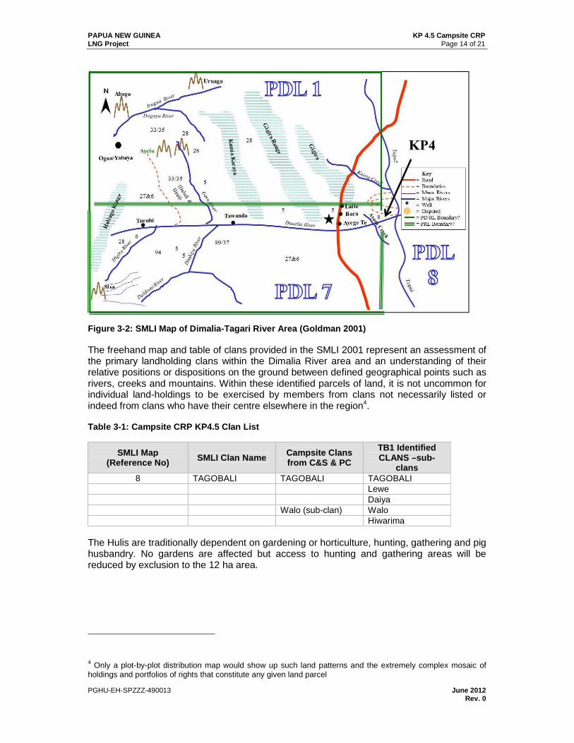
The affected campsite area in PDL8, formerly PRL11, was subject to several encompassing social mapping and landowner identification reports in 2001 for the PNG Gas Project and 2008 for the PNG LNG Project PRL11. Figure 3-2 below is the hand-drawn map from the PNG Gas Hides-Kutubu SMLI (Goldman 2001) and shows Tagobali (Map Ref. No.8; see Figure 3-1 ) to inhabit the north side of Dimalia River close to its junction with the Tagari River. Walo sub-clan of Tagobali clan claim ownership of campsite KP 4.5.
PAPUA NEW GUINEA KP 4.5 Campsite CRP LNG Project Page 14 of 21
PGHU-EH-SPZZZ-490013 June 2012 Rev. 0
Figure 3-2: SMLI Map of Dimalia-Tagari River Area ( Goldman 2001)
The freehand map and table of clans provided in the SMLI 2001 represent an assessment of the primary landholding clans within the Dimalia River area and an understanding of their relative positions or dispositions on the ground between defined geographical points such as rivers, creeks and mountains. Within these identified parcels of land, it is not uncommon for individual land-holdings to be exercised by members from clans not necessarily listed or indeed from clans who have their centre elsewhere in the region4.
Table 3-1: Campsite CRP KP4.5 Clan List
SMLI Map (Reference No) SMLI Clan Name Campsite Clans
from C&S & PC
TB1 Identified CLANS –sub-
clans 8 TAGOBALI TAGOBALI TAGOBALI
Lewe Daiya Walo (sub-clan) Walo Hiwarima
The Hulis are traditionally dependent on gardening or horticulture, hunting, gathering and pig husbandry. No gardens are affected but access to hunting and gathering areas will be reduced by exclusion to the 12 ha area.
4 Only a plot-by-plot distribution map would show up such land patterns and the extremely complex mosaic of holdings and portfolios of rights that constitute any given land parcel

PAPUA NEW GUINEA KP 4.5 Campsite CRP LNG Project Page 15 of 21
PGHU-EH-SPZZZ-490013 June 2012 Rev. 0
3.3 Types of Land Rights and Land Ownership
The Huli have agnatic descent and lived traditionally in scattered households. The most important social groups to which an individual belongs are the totemic patrilineal clans (hameigini─‘father-son line’). Most clans have representatives in more than one village— i.e., the totemic named clans are dispersed—so that what one encounters in each place is in effect a local clan segment. A more detailed understanding of Huli social structure, land tenure principles and cultural behavior is contained in the Komo Airstrip and HGCP RAPs and need not be reproduced or duplicated here.
3.4 IPCAs and Project Socio-Cultural Context
The IPCA for the campsite was signed on the 13th December 2011.
3.4.1 Land Requirements
3.4.1.1 Land Needs
The land-take for the Campsite area is 12.0 ha. IPCA compensation rates for loss of forested areas are detailed in Table 5-1. No loss of gardens or private trees are expected but these will be compensated at FRV should they be encountered.
All construction, logistics and labor resource activities will be undertaken in accordance with the Social Management Plans. The construction footprint shall be demarcated and works shall not be permitted to exceed the designated areas as defined in Figure 1-2 . Negotiations will be conducted with landowners with respect to the rehabilitation and return of the Campsite area, taking account of environmental considerations.
3.5 Cultural Heritage and Archaeological Sites
The initial archaeological research on this area was undertaken for the Project EIS SIA 2009. The findings were written up in the section Hides Gas Conditioning Plant Site (Ketereanda) to Tagari River. A total of 34 cultural sites were recorded during brief interviews with the members of the Tagobali and Taguali clans. Most of the sites were identified above the malaria zone (1,300 m) of the Tagari River and on the north banks of its tributary (the Dimalia River).
There were no cultural heritage sites identified in the ground survey undertaken in September 2011.
3.6 Social Sites
There were four social features/assets identified within the KP 4.5 Campsite survey area but outside the campsite construction footprint. The social features/assets are comprised of one house, one chicken house and three active gardens (see Figure 3-3). Specific care will be taken to avoid sites 09-SO-103, 09-SO-104 and 09-SO-105 (see Table 3-2) which are close to the proposed intervention.
Table 3-2: KP 4.5 Social Sites
KP Social Site Comment
09-SO-103 Active garden about 20 m x 10 m consists of mainly kaukau.
Will be avoided as it is outside construction footprint.
09-SO-104 A newly built house. Will be avoided as it is outside construction footprint.
09-SO-105 A newly built chicken house. Live chickens in the house at the time of survey.
Will be avoided as it is outside construction footprint.

PAPUA NEW GUINEA KP 4.5 Campsite CRP LNG Project Page 16 of 21
PGHU-EH-SPZZZ-490013 June 2012 Rev. 0
Figure 3-3: KP 4.5 Social Sites

PAPUA NEW GUINEA KP 4.5 Campsite CRP LNG Project Page 17 of 21
PGHU-EH-SPZZZ-490013 June 2012 Rev. 0
4.0 CONSULTATION AND DISCLOSURE
4.1 Stakeholder Engagement
A public disclosure meeting was held on 26 November 2011 (Table 4-1). The Environmental Law Centre (ELC) played an active monitoring and review role as an impartial observer. Representatives of the Tagobali clan were present during the PCS surveys and all clans have given verbal consent for the development. Issues raised in the public meeting echoed similar concerns voiced at the TB1. These, for the most part, centered on the perceived and claimed shortage of land that would now ensue given the multiple takes of Tagobali resources by the project. Table 4-2 presents a summary of the landowner concerns.
Table 4-1: KP 4.5 Public Disclosure Meeting
Resettlement Awareness
Village Date Awareness Team*
Number of Attendees Male Female Children Total
Obai 26 November 2011 RIT, L&CA 35 19 10 64
Table 4-2: Summary of KP4.5 Campsite Public Consult ation
Question/Issue Answer Subject Category
Follow -up Required
Recommend ed Action
Campsite KP4.5 Proposal (1) Appealed to CA to take note that this same clan Tagobali has given most of its clan land to the HGCP site, TB1 site and the Pipeline. (2) At TB1 a Landowner company has gone into Joint Venture with MCJV, this Landowner company does not serve the interest of the Landowners. (3) Not happy with the IPCA that is already in place at HGCP as most of the forest area has been cleared and given to the company but benefits do not reflect the value of what has been taken by the company.
Issue of ensuring that legitimate Landowner Company is identified to go into Joint Ventures with the Contractor can be addressed with Business Development- CA and that should be discussed with BD-CA. The other issue with IPCA benefits not sufficient is a matter for negotiation and those should be discussed before IPCAs are signed. The rates are FRV and there is an avenue in the Oil & gas Act that gives the Landowners the right of appeal the rate if they can prove that what has been is disputed.
Business development and IPCA benefits
Advise L&CA
L&CA to address information
The Tagobali Clan has given up 250 hectares at HGCP and compensation is very low. These hectares for KP4.5 will be added onto the Hectare that we have given up at HGCP. We are upset that we have signed the IPCA without proper awareness and advice.
We will pass this on to L&CA. Meanwhile ELC is here to assist you further with the whole Resettlement process.
IPCA Consultation and Disclosure
Advise L&CA
L&CA to address information
PAPUA NEW GUINEA KP 4.5 Campsite CRP LNG Project Page 18 of 21
PGHU-EH-SPZZZ-490013 June 2012 Rev. 0
Question/Issue Answer Subject Category
Follow -up Required
Recommend ed Action
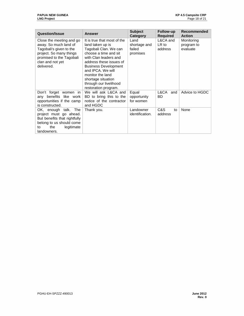
Close the meeting and go away. So much land of Tagobali's given to the project. So many things promised to the Tagobali clan and not yet delivered.
It is true that most of the land taken up is Tagobali Clan. We can choose a time and sit with Clan leaders and address these issues of Business Development and IPCA. We will monitor the land shortage situation through our livelihood restoration program.
Land shortage and failed promises
L&CA and LR to address
Monitoring program to evaluate
Don’t forget women in any benefits like work opportunities if the camp is constructed.
We will ask L&CA and BD to bring this to the notice of the contractor and HGDC
Equal opportunity for women
L&CA and BD
Advice to HGDC
OK, enough talk. The project must go ahead. But benefits that rightfully belong to us should come to the legitimate landowners.
Thank you. Landowner identification.
C&S to address
None

PAPUA NEW GUINEA KP 4.5 Campsite CRP LNG Project Page 19 of 21
PGHU-EH-SPZZZ-490013 June 2012 Rev. 0
5.0 PROJECT IMPACTS
Table 5-1: Principal Impacts likely to be experienc ed by KP 4.5 Campsite Landowners
Impact Scale Mitigation – Project Responses
Residential, business or other structures affected
None. None (if structures are encountered then protocols detailed in the HGCP RAP will be implemented.)
Loss of trees and crops
None
As per O&GA Section 118 and Eligibility Matrix landowners are entitled to one-off damage compensation payments, should losses arise. Garden and tree owners will be compensated for loss of crops and trees at FRV.
Loss of forest/other natural resources
Access to 12.0 ha of communal forest resources.
As per O&GA Section 118 and Eligibility Matrix these affected landowners are entitled to temporary loss, damage as well as deprivation compensation. All currently negotiated rates will be verified against full replacement values (market rates). These payments will be made to the Tagobali (Walo) clan. In the event of disputes, the money is held in reserve by the Project until the dispute has been resolved, either formally through the court system or informally.
Disruption in social networks
No physical relocation. Some affect from contractors’ workers operating in the area during construction.
Minimal. Contractor’s workers will be housed within a closed camp environment to minimize the effect associated with the introduction of large numbers of people into the community.
Impacts on Business/ Employment
No existing business will be impacted.
No loss of employment anticipated and there are no businesses, which require relocation or compensation.
Cultural Sites None Cultural Heritage Management Plan in place. Compensation to be paid to landowners for chance finds.
Influx of Migrants
Minimal owing to the nature of use and the short duration.
The project will work with local authorities to discourage settlement and the establishment of roadside stalls. Camp residents will be restricted from interacting with these settlers or traders. Employment will not take place at the camp gate.
5.1 Cumulative Impacts
The Project acknowledges that Tagobali clan land resources have been impacted multiple times by the interventions at HGCP, TB1, and KP4.5. However, whilst the holdings are notionally under ‘one clan’ name, the actual land holders and users often differ across the various sites. Nevertheless, landowners have expressed their concerns about the repeated erosion of clan land resources and the Project will monitor households for potential vulnerability to land scarcity.

PAPUA NEW GUINEA KP 4.5 Campsite CRP LNG Project Page 20 of 21
PGHU-EH-SPZZZ-490013 June 2012 Rev. 0
6.0 ELIGIBILITY AND ENTITLEMENTS
The RPF provides a full schedule of eligibility criteria for compensation and entitlements that will be adopted for the Project. The entitlements for the Campsite area will be the same as those detailed in previous CRPs5.
7.0 LIVELIHOOD RESTORATION PROGRAM
No gardens or privately owned trees are affected. Should these be encountered then the Project will ensure it restores impacted livelihoods in accordance with IFC PS 5 and the RPF as detailed in the HGCP RAP (Section 8)6.
8.0 GRIEVANCE MANAGEMENT FRAMEWORK
The resettlement process for KP 4.5 Campsite landowners will consider grievances through the Grievance Procedure which will apply across all Project activities. The Grievance Procedure is available to people affected by the Project, other local populations residing in the Project impact area, and other stakeholders directly affected by the Project.
The Grievance Procedure to be adopted for the Campsite Area is defined in the RPF. The Project will disclose information about the Grievance Mechanism to the affected Campsite communities, adjoining landowners and interested persons and organizations. The transparency and fairness of the process will be explained through both verbal (via regular stakeholder meetings) and written updates (such as newsletters and posters). The grievance procedure has been explained to communities in the KP 4.5 area.
9.0 ORGANIZATIONAL ROLES AND RESPONSIBILITIES
The Company is responsible for overall resettlement planning, implementation and monitoring as per the RPF, which is implemented by the Land & Community Affairs Team. Organizational details are described in the HGCP RAP, Section 10.
10.0 MONITORING AND EVALUATION
The Monitoring and Evaluation system (M&E) provides Project management and directly affected persons and households, with timely, concise, indicative information on whether individual compensation and resettlement activities are on track and achieving Project goals.
Further principles of the monitoring process to be implemented can be obtained from the HGCP RAP section 11. The following parameters will be monitored in the event of physical displacement: timely payment of compensation; unforeseen impacts of changes to livelihood; complaints about project social or environmental performance; and timely and effective close-out of grievances.
5 Such as the Kutubu to Kantobo CRP. 6 Hides Gas Conditioning Plant Resettlement Action Plan, May 2010 (Revised November 2010).

PAPUA NEW GUINEA KP 4.5 Campsite CRP LNG Project Page 21 of 21
PGHU-EH-SPZZZ-490013 June 2012 Rev. 0
11.0 IMPLEMENTATION SCHEDULE
Table 11-1 below sets out an estimated timeframe of the tasks required to implement the CRP.
Table 11-1: CRP Implementation Schedule
Activity or Task Actions 2011 2012
D J F M A+ Planning Completion of Campsite CRP Approvals Internal EHL approval of the CRP
CRP Submission to Lenders CRP Summary to community
Land Issues Confirm resettlement sites and any impacted water sources (provision)
Confirm and finalize compensation agreements
Verify inventories of affected land and assets (incl. special valuations)
Confirmation of any vulnerable households Finalize any entitlement contracts
Compensation payments
IPCA payments to clans and cash payments to individuals (provision - gardens)
Graves, spiritual and other cultural sites
Relocate / recover (provision)
Livelihood restoration
Implement programs (provision)
Verification and monitoring
Design and implementation of monitoring and evaluation system (ending Jan 2014)
Local advocacy and compensation advisors
Internal monitoring External evaluation (including completion audit)
12.0 COST AND BUDGET ESTIMATE
Budget provision of US$ 0.1 million is included for forest damage and deprivation costs to clans as well as other social infrastructure