Embed Size (px)
Citation preview

Phase 1 - Design CodeNorthstowe
April 2014
Approved by the Northstowe Joint Development Control Committee, 12th May 2014 in relation to discharge of condition 8 of outline planning permission S/0388/12/OL


Preface
The new town of Northstowe is promoted jointly by Gallagher, an experienced master developer and property investment company, and the Homes and Communities Agency (HCA), the government’s national housing and regeneration agency for England.
Northstowe is designed as a 21st century town in Cambridgeshire with up to 10,000 residential units that will take shape over a period of 15 - 20 years. It aims to achieve the highest quality of community living, conserving precious resources, and will contribute to the local identity of the area.
The town wide design code (part 2) has been prepared by the joint promoters to ensure that a cohesive and high quality development is delivered at Northstowe. The design code for phase 1 (part 3 and part 4) has been prepared solely by Gallagher.
The production of the code has been a collaborative process involving South Cambridgeshire District Council (SCDC), Cambridgeshire County Council and the Northstowe Parish Forum.
The design code document comprises four parts. Part 1 provides an introduction to the document and the context for its preparation, including the vision for Northstowe. Part 2 sets out the strategic town wide design principles, with only those elements relevant to phase 1 being mandatory. Part 3 and part 4 provide a detailed design code for phase 1 in accordance with the design principles established by the outline planning consent, part 3 dealing specifically with movement and the public realm. This code will be used primarily to review reserved matters applications against the agreed vision and design criteria established for the first phase of Northstowe.
© Terence O’Rourke Ltd 2014. All rights reserved. No part of this document may be reproduced in any form or stored in a retrieval system without the prior written consent of the copyright holder.
All figures (unless otherwise stated) © Terence O’Rourke Ltd 2014.Based upon the 2013 Ordnance Survey mapping with the permission of the Ordnance Survey on behalf of Her Majesty’s Stationery Office © Crown Copyright Terence O’Rourke Ltd Licence number 100019980.

CONTENTS PREFACEFIGURE LIST
PART 01 INTRODUCTION & VISION
01 INTRODUCTION page 8
1.1 Purpose of the document
1.2 Planning context
1.3 Code structure and use of document
1.4 Review
1.5 The site and context
02 VISION page 14
2.1 A 21st century Cambridgeshire town
PART 02 TOWN WIDE CODING
03 STRUCTURING ELEMENTS page 20
3.1 Landscape
3.2 Urban form
3.3 Streetscape
04 CHARACTER DISTRICTS page 34
4.1 North
4.2 Centre
4.3 South

PART 04 PHASE 1 CODING
08 SITE WIDE REGULATIONS page 110
8.1 Block structure
8.2 Green infrastructure
8.3 Youth & children’s play
8.4 Parking
8.5 Bins and utilities
8.6 Building design principles
8.7 Sustainability strategy
09 IDENTITY AREA SPECIFIC CODING page 134
9.1 Identity area introduction
9.2 T1 - Spine
9.3 T2 - Suburban spine
9.4 T3 - Urban neighbourhood
9.5 T4 - Suburban neighbourhood
9.6 T5 - Longstanton edge
9.7 T6 - Water park edge
10 COMMERCIAL & COMMUNITY BUILDINGS page 172
10.1 Mixed use centre
10.2 Primary school
10.3 Sports hub
10.4 Employment areas
11 DELIVERY & PHASING Page 182
Appendix 1: Compliance with condition 8 of outline planning permission for Phase 1
PART 03 PHASE 1 PRIMARY INFRASTRUCTURE
05 PHASE 1 page 54
5.1 Phase 1 site and context
5.2 Phase 1 vision
5.3 Phase 1 scheme
06 MOVEMENT page 62
6.1 Walking network
6.2 Bicycle network
6.3 Public transport
6.4 Streets hierarchy
6.5 Dedicated busway
6.6 Primary streets
6.7 Secondary streets
6.8 Tertiary streets / mews
6.9 Speed management
6.10 Street trees
6.11 On street parking
07 HIGHWAY PUBLIC REALM page 94 7.1 Squares
7.2 Materials

FIGURE LIST
PART 02 TOWN WIDE CODINGPART 01 INTRODUCTION & VISION
Figure 3.1 Landscape structure
Table 3.1 Landscape structuring elements
Figure 3.2 Urban form diagram
Table 3.2 Townscape structuring elements
Figure 3.3 Figure 3.3 Typical street section
Figure 3.4 Street hierarchy diagram
Table 3.3 Streetscape structuring
elements
Figure 4.1 Character districts
Figure 4.2 North character district
Figure 4.3 Key routes
Figure 4.4 Landscape
Figure 4.5 School catchments
Figure 4.6 LEAP & NEAP catchments
Figure 4.7 Sports hub
Figure 4.8 Drainage and topography
Figure 4.9 Indicative design of
neighbourhood centre
Figure 4.10 Indicative 3D view of massing
on Longstanton edge
Figure 4.11 Location plan - Longstanton
edge
Figure 4.12 Indicative plan Longstanton
edge
Figure 4.13 Indicative 3D view of water park
edge
Figure 4.14 Location plan - water park
Figure 4.15 Indicative plan water park edge
Figure 4.16 Central character district
Figure 4.17 Key routes
Figure 4.18 Landscape
Figure 4.19 School catchments
Figure 4.21 Sports hub Figure 4.20 LEAP &
NEAP catchments
Figure 4.22 Drainage and topography
Figure 4.23 Artist’s impression - Indicative
sketch of town centre market
square
Figure 4.24 Location plan - town centre
Figure 4.25 Indicative plan local centre
Figure 4.26 Indicative 3D view of massing in
town centre
Figure 4.27 Indicative 3D view of massing in
former barracks
Figure 4.28 Block layout of former barracks
area
Figure 4.29 Indicative plan former barracks
Figure 4.30 Indicative section Rampton Drift
edge
Figure 4.31 Location plan - Rampton Drift
edge
Figure 4.32 Indicative plan Rampton Drift
edge
Figure 4.33 South character district
Figure 4.34 Key routes
Figure 4.35 Landscape
Figure 4.36 School catchments
Figure 4.37 LEAP & NEAP catchments
Figure 4.38 Sports hub
Figure 4.39 Drainage and topography
Figure 4.40 Indicative plan neighbourhood
centre
Figure 4.41 Indicative plan Oakington edge
Figure 4.42 Indicative plan water park edge
Figure 4.43 Indicative 3D sketch of
Oakington edge
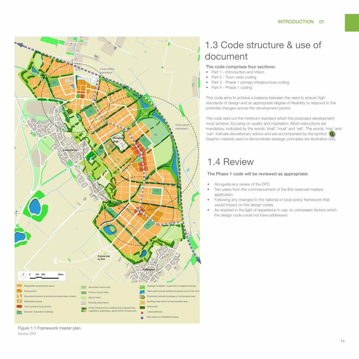
Figure 1.1 Framework master plan

PART 03 PHASE 1 PRIMARY INFRASTRUCTURE PART 04 PHASE 1 CODING
Figure 8.1 Indicative block layout
Figure 8.2 Clearly defined public - private
edge
Figure 8.3 Minimum distance from back to
back units
Figure 8.4 Busway and primary routes
Figure 8.5 Green infrastructure
Figure 8.6 B1050 & local centre
Figure 8.7 Green infrastructure plan
Table 8.1 Green infrastructure
Figure 8.8 Indicative section showing
cycle /pedestrian bridge across
greenway
Figure 8.9 Play area catchments
Table 8.2 Play area components
Table 8.3 Summary of approved play
provision across the new
development
Table 8.4 Cycle parking
Figure 8.10 Parking arrangement for public
realm – diagonal
Figure 8.11 Approved garage dimensions
Table 8.5 General site wide parking
arrangement principles
Table 8.6 Bins and utilities
Figure 8.12 Primary street
Figure 8.13 Secondary street
Figure 8.14 Shared space
Table 8.7 Materials & treatment
Figure 9.1 Identity areas
Figure 9.2 Regulating plan
Figure 9.3 Indicative sketch showing
grouping of typologies
Figure 9.4 Illustrative plan - spine
Figure 9.5 Illustrative section through the
spine
Figure 9.6 Regulating plan
Figure 9.7 Indicative sketch showing
grouping of typologies
Figure 9.8 Illustrative plan - suburban spine
Figure 9.9 Illustrative section through
suburban spine identity area
Figure 9.10 Regulating plan
Figure 9.11 Indicative sketch showing
grouping of typologies
Figure 9.12 Illustrative plan - urban
neighbourhood
Figure 9.13 Illustrative section through urban
neighbourhood identity area
Figure 9.14 Regulating plan
Figure 9.15 Indicative sketch showing
grouping of typologies
Figure 9.16 Illustrative plan - suburban
Figure 9.17 Illustrative section through the
suburban identity area
Figure 9.18 Regulating plan
Figure 9.19 Indicative sketch showing
grouping of typologies
Figure 9.20 Illustrative plan - Longstanton
edge
Figure 9.21 Illustrative section through
Longstanton edge
Figure 9.22 Regulating plan
Figure 9.23 Indicative sketch showing
grouping of typologies
Figure 9.24 Illustrative plan - water park edge
Figure 9.25 Illustrative section through water
park edge identity area
Figure 10.1 Indicative land use plan of the
local centre
Figure 10.2 Indicative sketch plan of primary
school site
Figure 10.3 Indicative sketch plan sports hub
Figure 10.4 Employment area
Figure 10.5 Indicative arrangement layout
Figure 10.6 Indicative arrangement section
Figure 5.1 Site constraints plan from DAS
Figure 5.2 Phase 1 vision plan
Figure 5.3 Illustrative sketch master plan
Table 6.1 Walking routes
Figure 6.1 Indicative strategic walking
routes and linkages
Table 6.2 Cycle routes
Figure 6.2 Indicative strategic bicycle
routes and linkages
Table 6.3 Public transport
Figure 6.3 Indicative strategic public
transport diagram
Table 6.4 Street hierarchy
Figure 6.4 Street hierarchy diagram
Figure 6.5 Section - dedicated busway with
local road
Figure 6.6 Plan - dedicated busway with
local road
Figure 6.7 Section - dedicated busway with
rear parking
Figure 6.8 Plan - dedicated busway with
rear parking
Figure 6.9 Section primary street
Figure 6.10 Illustrative view of primary street
Figure 6.11 Section secondary street
Figure 6.12 Illustrative view of secondary
street
Figure 6.13 Section tertiary street type 1
Figure 6.14 Section tertiary street type 2
Figure 6.15 Illustrative view tertiary street
type 1
Figure 6.16 Illustrative view tertiary street
type 2
Table 6.5 Street trees
Table 6.6 On street parking
Table 7.1 Squares
Figure 7.1 Diagram showing public squares
location
Figure 7.2 Illustrative sketch design
Figure 7.3 Illustrative sketch design
Figure 7.4 Illustrative sketch design
Figure 7.5 Illustrative sketch design
Figure 7.6 Illustrative sketch design
Figure 7.7 Illustrative sketch design
Figure 7.8 Illustrative sketch design

01 INTRODUCTION
6
PART 01
Introduction& Vision
01 INTRODUCTION 1.1 Purpose of the document
1.2 Planning context
1.3 Code structure and use of document
1.4 Review
1.5 The site and context
02 VISION 2.1 A 21st century Cambridgeshire town

INTRODUCTION 01
7
PART 01
Introduction& Vision

01 INTRODUCTION
8
1.INTRODUCTION

INTRODUCTION 01
9
Cambridge
Ramsey
Cottenham
Northstowe
Cambridgeshire Guided Busway(CGB)
March
St IvesHuntingdon
Ely
Longstanton
Oakington
Towns / settlements marked in red are used for contextual analysis to determine key aspects of Northstowe.

01 INTRODUCTION
10
1.1 Purpose of the document
1.2 Planning contextSouth Cambridgeshire Local Development Framework (LDF)
The LDF is a suite of documents adopted by South Cambridgeshire District Council (SCDC) which together guide development in South Cambridgeshire. It includes the Core Strategy, Development Control Policies Development Plan Document (DPD), a series of Area Action Plans, a Site Specific Policies DPD, a Proposals Map, Supplementary Planning Documents, a Local Development Scheme, Statement of Community Involvement and Annual Monitoring Report.
Core Strategy, January 2007The Core Strategy sets out the overall approach to development in the district and allocates Northstowe new town for the development of up to 10,000 homes.
Northstowe Area Action Plan (NAAP), July 2007SCDC formally adopted the NAAP, which forms the principal planning policy framework guiding the delivery of Northstowe, in July 2007.
Northstowe Development Framework Document (DFD), August 2012The DFD, prepared in accordance with the NAAP, was endorsed by the NJDCC on 20 July 2012. The final document was published in August 2012.
The DFD refreshes the master plan for Northstowe by making it relevant to today’s circumstances. It also defines the rationale and structure for Northstowe’s planning and delivery as a comprehensive development and enabled phase 1 to come forward
as part of an integrated whole whilst providing place making principles and guidance for individual phases of development.
The spatial planning and urban design principles of the DFD are founded on the vision, development principles and policies of the NAAP. In undertaking a comprehensive master plan review and preparing the DFD, account was taken of more recent and emerging changes in national and local planning policy and of current and likely future economic circumstances.
As a consequence, the proposal for Northstowe was strengthened and brought up-to-date to ensure a viable scheme creating a sustainable community. The new town is to be built to high standards of design and layout within a framework of green infrastructure comprising formal and informal open space and wildlife habitat corridors.
Northstowe DFD Addenda, October 2012
In response to comments raised by the NJDCC on 20 July 2012, two addenda were prepared to support the DFD, titled:
• An exemplar of sustainable living – which sets out the exemplar, unique and special aspects that Northstowe aspires to achieve
• Phasing and delivery strategy – which sets out the broad strategy for delivery of the town
Both documents were endorsed by the NJDCC on 4 October 2012.
Phase 1 outline planning permission and design code
The outline planning permission (SCDC ref: S/0338/12/OL) includes a condition (no. 8) requiring the preparation of a Design Code for the Phase 1 development. This document addresses all the matters raised in that planning condition, as set out within appendix 1. Future reserved matters applications for Phase 1 All reserved matters submissions will need to take the design code into account alongside other material considerations, and are required by condition 8 of the outline planning permission to be accompanied by a statement demonstrating compliance with the code. Outline planning applications for future phases of Northstowe Alongside the DFD, parts 1 and 2 of the code should be used to inform proposals and related outline planning applications for future phases of Northstowe.
The design code sits within a set of documents, all of which contain design guidance. These comprise:
• Northstowe Area Action Plan (NAAP)• Development Framework Document (DFD)• Phase 1 Design and Access Statement
Part 1(introduction & vision) and part 2 (town wide coding) of the document are intended to bridge the gap between the design guidance provided within the Development Framework Document (DFD) and
to provide town wide design guidance on strategic issues from which detailed design codes can be developed as individual phases of Northstowe come forward after phase 1. Part 3 and part 4 of the document provide design guidance for the first phase of Northstowe and only cover design matters relevant to the outline consent for phase 1.
The process and structure of the design code is in accordance with the councils’ Informal Guidance Note, Design Codes for Strategic Development
Sites within the Cambridge Fringe areas and Northstowe. This was adopted by the Northstowe Joint Development Control Committee (NJDCC) on 28 November 2012.
INTRODUCTION 01
11
The code comprises four sections: • Part 1 - Introduction and Vision • Part 2 - Town wide coding • Part 3 - Phase 1 primary infrastructure coding• Part 4 - Phase 1 coding
This code aims to achieve a balance between the need to ensure high standards of design and an appropriate degree of flexibility to respond to the potential changes across the development period.
The code sets out the minimum standard which the proposed development must achieve, focusing on quality and inspiration. Most instructions are mandatory, indicated by the words ‘shall’,’must’ and ‘will’. The words ‘may’ and ‘can’ indicate discretionary advice and are accompanied by the symbol G. Graphic material used to demonstrate strategic principles are illustrative only.
1.3 Code structure & use of document
1.4 ReviewThe Phase 1 code will be reviewed as appropriate:
• Alongside any review of the DFD • Two years from the commencement of the first reserved matters
application• Following any changes to the national or local policy framework that
would impact on the design codes• As required in the light of experience in use, or unforeseen factors which
the design code could not have addressed
G
Figure 1.1 Framework master plan Source: DFD
Town centre
catchment
Local centre
catchment
Longstanton
Oakington
Rampton
Drift
Future link to A14
PS
PS
PS
PS
SS
PS
PS
PS
Strategic footpath / cycle links to neighbourhoods
Attenuation ponds (additional ponds north of the A14)
Potentially retained buildings in old barracks area
Existing trees within former barracks area
Allotments
Listed pillboxes
Bus stops on dedicated busway
Secondary school site
Primary school sites
Sports hubs
Existing settlements
Green infrastructure, existing and proposed key vegetation, greenways, green buffer & linear park
SS
PS
Residential development areas
Employment
Movement network of primary and secondary streets
Dedicated busway
Town centre & local centres
Schools / education buildings
0 100 200 500m

01 INTRODUCTION
12
1.5 Site context
Aerial view of site circa 2007
The site of Northstowe benefits from its strategic location on the route of the high speed transport corridor of the Cambridgeshire Guided Busway (CGB) between Cambridge and Huntingdon.
The immediate context is formed by the existing settlements of Longstanton to the west of the site and Oakington to the south.
The site is generally open in character with a combination of varied agricultural fields with groups of substantial vegetation; a former airfield and barracks area, the latter with formal planting and a tree lined avenue; and a golf course with footpaths providing linkages and connections through the site.
Longstanton
Rampton Drift
CGB (Cambridgeshire G
uided Busw
ay)
Oakington

INTRODUCTION 01
13

02 VISION
2. VISIONNorthstowe will be a vibrant 21st century town with a strong local identity. It will combine the best historic characteristics of local settlements with provision for more sustainable patterns of living and lifestyle choices. Northstowe will be built to high environmental standards and will be flexible to provide the opportunity for some development parcels to reflect new and future advances in sustainable design
The vision for Northstowe reflects the Cambridgeshire Quality Charter for growth which promotes planned growth of sustainable and vibrant new communities in accordance with four themes:
COMMUNITY
CLIMATE
CONNECTIVITY
CHARACTER
The vision also accords with the approach outlined in both the ‘Northstowe Development Framework Document Addendum: An exemplar of sustainable living’ and the ‘Northstowe Vision: A Strategic Action Framework’.
14

VISION 02
15

02 VISION
2 1 s t c e n t u r y t ow
n o
f Cam
bridgeshire Thriving com
mu
nit
y i
n t
r ad i t i
o n a l s e t t i n g
Walkableneighbourhoods cycle networkLocally distinct vernacular
materials/forms
Strong green infrastructure
Community living
Family living
Market town - traditional high street
Food production
TRADITIONAL INFLUENCE
Northstowe
Residential street designed to a human scale
Local market brings temporary activity to the street
Church at the centre of the community
A public square which can facilitate a variety of uses
16

VISION 02
2 1 s t c e n t u r y t ow
n o
f Cam
bridgeshire Thriving com
mu
nit
y i
n t
r ad i t i
o n a l s e t t i n g
Walkableneighbourhoods cycle network
Healthy living
Cambridgeshire Guided Busway - smart & sustainable transport system
Renewable energy
Energy conservationFabric first
Ecological habitat protection
Superfast broadband
Water and waste management in an environmentally responsive way
Northstowe
21ST CENTURY INFLUENCE
New housing generated by energy saving priorities
Prioritising public transport accessibility
Schools increasingly at the centre of the community
Multi-use community buildings
17