Embed Size (px)
Citation preview

Phase 1 Report
May 30, 2017

Santa Cruz County Regional Transportation Commission
Highway 9 - San Lorenzo Valley Complete Streets Corridor Transportation Plan (SR9/SLV Plan) | Phase 1 Report
Kimley Horn, Inc., TrailPeople May 31, 2017 1
Table of Contents 1. Introduction and Summary ............................................................................................................................................................ 4
1.1. Project Goal ........................................................................................................................................................................... 4
1.2. Study Area ............................................................................................................................................................................. 5
1.3. Project Objectives .................................................................................................................................................................. 6
1.4. Study Process ........................................................................................................................................................................ 7
2. Study Area Conditions .................................................................................................................................................................. 9
2.1. Background Documents and Plans ...................................................................................................................................... 10
2.2 Prior Public Input.................................................................................................................................................................. 12
2.3. Overall Transportation Corridor Condition Maps .................................................................................................................. 13
2.4. Existing Bicycle and Pedestrian Access Conditions Maps .................................................................................................... 15
3. Funding Opportunities ................................................................................................................................................................. 16
3. Draft Evaluation Criteria .............................................................................................................................................................. 18
4. Alternative Improvement Types - Toolkit ..................................................................................................................................... 21
5. Site-Specific Improvement Concepts and Alternatives ................................................................................................................ 27
1. Improved bicycle and pedestrian connection – Henry Cowell State Park to Felton .................................................................. 28
Add minimum 4’ shoulders/bike Lanes with path on east side (Survey option 1): ........................................................................ 28
2. More organized parking/frontage in downtown Felton.............................................................................................................. 30
a. Convert to 45-degree angled parking, improve walkways at store fronts; add center turn lane (Survey option 2) .................... 30
b. Convert to separated 30 degree angled parking or conventional parallel parking with sidewalks in ROW (Survey option 3) ... 31
c. Colored/textured shoulders ..................................................................................................................................................... 33
3. Bicycle and pedestrian access at Graham Hill Road intersection ............................................................................................ 34
a. Narrow the lanes to add space for bikes on the shoulder and a continuous sidewalk (Survey option 4) .................................. 35

Santa Cruz County Regional Transportation Commission
Highway 9 - San Lorenzo Valley Complete Streets Corridor Transportation Plan (SR9/SLV Plan) | Phase 1 Report
Kimley Horn, Inc., TrailPeople May 31, 2017 2
b. Convert the intersection to a roundabout (Survey option 5) ..................................................................................................... 35
4. Bicycle and pedestrian connection to SLV schools from central Felton ................................................................................... 36
a. Separate Class I path on west side (Survey option 6) ............................................................................................................. 42
b. Narrow lanes and add buffered bike (and pedestrian) lane on west side (Survey option 7) ..................................................... 42
c. Add sidewalk on east side ....................................................................................................................................................... 43
d. Cooper/Clearview/Fall Creek Bypass ...................................................................................................................................... 43
5. Transit and sidewalk access improvements SLV school entrance to Fall Creek Drive (Survey option 9). ................................ 44
6. Improved bicycle and pedestrian connection from schools north to El Solyo Heights Drive ..................................................... 46
a. Add a sidewalk or path on west side above/behind the existing retaining walls (Survey option 10) ......................................... 46
b. Bypass via El Solyo Heights Drive/Hacienda Way (Survey option 11) ..................................................................................... 47
7. Crossing and Pedestrian Improvements at/to Mill Street/Highway 9 in Ben Lomond (Survey option 12). ................................. 48
a. Add crosswalk warning lights and lighting at Highway. ............................................................................................................ 48
b. Add a walkway from Pine Street to Highway 9. ....................................................................................................................... 48
8. Pathway on SW side of SR 9 from Quality Inn/bridge south to Mill Street in Ben Lomond (Survey option 13) ......................... 49
9. Add crosswalk bulb-outs in downtown Boulder Creek (Survey option 14) ................................................................................ 50
10. Sidewalk seating and storefront improvements in downtown Boulder Creek (Survey option 15). ......................................... 53
Santa Cruz County Regional Transportation Commission
Highway 9 - San Lorenzo Valley Complete Streets Corridor Transportation Plan (SR9/SLV Plan) | Phase 1 Report
Kimley Horn, Inc., TrailPeople May 31, 2017 3
Table of Figures Figure 1: Project Study Area Map ........................................................................................................................................................ 5
Figure 2: Word cloud based on prior public input ............................................................................................................................... 12
Figure 3: Sample Vehicular Conditions Map ...................................................................................................................................... 14
Figure 4: Sample bike and pedestrian condition map ......................................................................................................................... 15
Figure 5: Bicycle and pedestrian Improvements from Henry Cowell State Park to Felton ................................................................... 29
Figure 6: Highway 9 pedestrian improvements from Felton Town Plan .............................................................................................. 30
Figure 7: Sample layout of angled parking ......................................................................................................................................... 31
Figure 8: Conceptual layout of sidewalk protected angled parking and bike lanes ............................................................................. 32
Figure 9: Section for the south side .................................................................................................................................................... 32
Figure 10: SLV Schools to Felton Corridor ......................................................................................................................................... 37
Figure 11: Constrains on west side of SR 9 ....................................................................................................................................... 38
Figure 12: Cross-section with path constructed above wall ................................................................................................................ 42
Figure 13: Cross-section of path above wall ....................................................................................................................................... 46
Figure 14: Connection from SLV Schools North ................................................................................................................................. 47
Figure 15: Proposed bulb-out and pedestrian safety improvement locations ...................................................................................... 51
Figure 16: As-builts for Highway 9 in Boulder Creek .......................................................................................................................... 54

Santa Cruz County Regional Transportation Commission
Highway 9 - San Lorenzo Valley Complete Streets Corridor Transportation Plan (SR9/SLV Plan) | Phase 1 Report
Kimley Horn, Inc., TrailPeople May 31, 2017 4
1. Introduction and Summary The Santa Cruz County Regional Transportation Commission (SCCRTC) is leading this study of the State Route 9 San Lorenzo
Valley Corridor using a “Complete Streets” study grant from Caltrans. Working with a team of County and state agencies and the
office of Supervisor Bruce McPherson, and supported by a team of transportation consultants, SCCRTC is conducting a thorough
public outreach and participation process to ensure that this is a true “community-based plan.” The study builds on extensive prior
studies, plans and public input regarding improvements to the highway transportation facilities in the San Lorenzo Valley (SLV).
This Phase 1 report presents:
• The goals, objectives and performance criteria for improvement projects;
• The background of studies, standards and existing conditions;
• Prior public input about improvements;
• Project funding opportunities;
• A “toolkit” of different improvement options applicable to this rural setting, and;
• Prior public and agency ideas for site-specific improvements.
The purpose of this phase is to get your input on these elements and ideas so we can create an action plan to implement a range of
projects along Highway 9 through SLV that will address community concerns and priorities along this important travel corridor, taking
advantage of $10 million in funding for SLV approved by the voters as part of Measure D, and other funding opportunities.
1.1. Project Goal The ultimate goal of the SR9/SLV Plan is to improve multi-modal access and connectivity, safety and security, operations,
economic vitality and environmental quality. It will seek to be consistent with and implement other pertinent plans and policies,
and it will seek to clarify and prioritize projects where there is the most need/demand, while considering cost and feasibility, so
improvement priorities reflect the most “bang for the buck.” This is a “Complete Streets” project, which means per Caltrans policy, “a
transportation facility that is planned, designed, operated, and maintained to provide safe mobility for all users, including bicyclists,
pedestrians, transit vehicles, truckers, and motorists, appropriate to the function and context of the facility.”
A well-designed complete street doesn’t just work better; it feels better, particularly for bicyclists and pedestrians, and it looks better,
with enhanced aesthetics and amenities that complement the setting and adjacent uses.

Santa Cruz County Regional Transportation Commission
Highway 9 - San Lorenzo Valley Complete Streets Corridor Transportation Plan (SR9/SLV Plan) | Phase 1 Report
Kimley Horn, Inc., TrailPeople May 31, 2017 5
1.2. Study Area The study area is the Highway 9 travel corridor through San
Lorenzo Valley, from Henry Cowell State Park in Felton, near
Glengarry Road, to the northern intersection of Highway 236
with Highway 9 north of Boulder Creek – a distance of
approximately 16.2 miles (see Figure 1). The focus of the study
is on the more “urbanized” areas from the Felton to Boulder
Creek town centers, a distance of approximately seven miles.
The study also considers some of the parallel county roadways
that SLV residents use as an alternate to Highway 9.
While the focus of this study is on the Highway 9 corridor
between Felton and Boulder Creek, the study also recognizes
that many people in San Lorenzo Valley travel south to the City
of Santa Cruz, west and east to Bonny Doon and Scotts Valley,
and north to the San Francisco Bay Area. However, these
routes to other areas could not be addressed within the limited
budget for the current study and community members had
determined that the area from Felton to Boulder Creek needed a
focused study. The connection from Felton to Santa Cruz was
the focus of the 2003 San Lorenzo Valley Trail Study. Caltrans
also has Transportation Concept Reports for all of Highway 9,
which provide a high-level overview of this state highway.
Concepts identified for more rural sections of Highway 9 through
the study area could also be applied to other areas of Highway
9 which have lower traffic volumes.
Figure 1: Project Study Area Map

Santa Cruz County Regional Transportation Commission
Highway 9 - San Lorenzo Valley Complete Streets Corridor Transportation Plan (SR9/SLV Plan) | Phase 1 Report
Kimley Horn, Inc., TrailPeople May 31, 2017 6
1.3. Project Objectives The main goal of the project is to create an actionable short-term and long-term multi-modal plan – with specific projects – to
increase safety and accessibility along Highway 9 and within the area’s town centers. Several overarching draft objectives have been
framed to support the overall goal. Public and stakeholder input is being sought in study Phase 1 regarding these DRAFT objectives
and their relative priorities. (Public input is also sought on the more specific improvement ideas and alternatives, as outlined in
Section 5)
1. Increase safety along the corridor
• Reduce crashes
• Traffic calming – slowing speeds while maintaining efficiency
• Intersection safety improvements
• Maintain roadways
2. Increase pedestrian and bicyclist access and safety along the corridor
• Make it easier to walk or bike in town centers
• Better bicycling connections between town centers and schools
• Better pedestrian connections between town centers and schools
• Make it easier to cross Highway 9
• Improve health, especially for youth
3. Improve transit facilities, routes to transit, and transit options
• Transit stop areas locations and amenities, including pathways to bus stops
• Access for people with limited mobility (e.g. seniors, people with disabilities, youth)
• Transit service, paratransit service,
• Rideshare/school pools, vanpools, Lyft/Uber
4. Provide economic benefits
• Greater flexibility in use of sidewalks/right-of-way near businesses
• Better organized commercial parking/frontages and access/driveways
• Maintain traffic flow and predictable travel times
5. Environmental improvements
• Maintain/enhance rural mountain character (avoid urban type improvements)
• Have less pavement; preserve vegetation where feasible

Santa Cruz County Regional Transportation Commission
Highway 9 - San Lorenzo Valley Complete Streets Corridor Transportation Plan (SR9/SLV Plan) | Phase 1 Report
Kimley Horn, Inc., TrailPeople May 31, 2017 7
• “Green” drainage to intercept and slow runoff
• Reduce emissions
6. Create a plan that can be realistically implemented in both short and medium term
• Pursue projects that can be implemented quickly (incl. “low-hanging fruit”)
• Purpose projects that have greatest benefit per dollar
• Identify priorities for Measure D 30-year revenues
• Capture maximum state, federal, and grant funding to leverage local measure funding
7. Create a vision and blueprint for the ultimate future corridor
• Have a plan that identifies improvements through the entire corridor
• Avoid piecemeal disconnected improvements – have a phased plan
• Provide design guidelines that facilitate Caltrans incorporating multi-modal improvements into other project types (drainage, bridges,
repaving, etc.)
1.4. Study Process This study and plan does not start with a blank slate – it builds on many years of prior public input and previous studies and plans,
particularly the Felton Town Plan (1987), the Ben Lomond Town Plan (1990), the Boulder Creek Specific Plan (1992), and the 2003
San Lorenzo Valley Trail Study funded by Caltrans and prepared for the Santa Cruz County Public Works Department. The study
team also considered the collected comments from several years of public meetings regarding transportation improvements in the
SLV/Highway 9 corridor. These comments are summarized in Appendix A and the results are reflected in the conceptual
improvement options presented below in the “toolkit” and the site-specific improvement ideas and options described below.
Corridor Plan Oversight Team Consisting of staff from Caltrans District 5, the Santa Cruz County Regional Transportation Commission, County Public Works
Department, County of Santa Cruz Planning, Santa Cruz Metropolitan Transit District (Metro), and Supervisor Bruce McPherson’s
office this group met at key intervals to guide and help complete the study and plan.
Study Stages The study and plan is expected to be completed in late 2017 or early 2018. There are three basic stages; the first two include a
thorough public outreach and engagement effort:

Santa Cruz County Regional Transportation Commission
Highway 9 - San Lorenzo Valley Complete Streets Corridor Transportation Plan (SR9/SLV Plan) | Phase 1 Report
Kimley Horn, Inc., TrailPeople May 31, 2017 8
Phase 1: Overall project goal, objectives, initial project ideas
Addresses: • Draft study goals, objectives • Project evaluation criteria and proposed process • Background documents and data • Illustration of improvement options – specific and general • Best potential funding sources
Outreach efforts: • RTC staff meets with key community groups and leaders • Press release, coverage in local media, social media, RTC and other agency web sites • Public workshop May 31 • Public opinion survey (overlaps workshop)
Phase 2: Draft plan development, review and refinement
Addresses: • Response to public and agency input from Phase 1 • Top ranked specific ideas– conceptual illustrations and description, costs/requirements • Criteria and process used for initial ranking • Overall long-term corridor vision (illustrate typical improved conditions, describe and quantify overall) • Assembly into an organized plan
Outreach efforts: • RTC staff meets with key community groups and leaders • Press release, coverage in local media, RTC and other agency web sites • Public workshop (in October? – an “open house” show casing draft improvement ideas and priorities) • Virtual workshop/survey online to receive input on the draft plan from the community.
Phase 3: Plan Finalization
Addresses: • Response to public and agency input from Phase 2 • Finalization of the plan
Outreach efforts: • Final plan available online • Present Final Plan to Board of Supervisors and Regional Transportation Commission

Santa Cruz County Regional Transportation Commission
Highway 9 - San Lorenzo Valley Complete Streets Corridor Transportation Plan (SR9/SLV Plan) | Phase 1 Report
Kimley Horn, Inc., TrailPeople May 31, 2017 9
2. Study Area Conditions This plan focuses on State Route 9 (SR9) and connecting streets, roads and paths between Felton and Boulder Creek in the Santa
Cruz mountains. SR 9 begins in the City of Santa Cruz at SR1 in Caltrans District 5. It winds through the Santa Cruz Mountains,
intersects with SR 236 in Boulder Creek and again near the San Mateo County line, intersects with SR 35 at the Santa Cruz/Santa
Clara County line, and continues into Caltrans District 4 until terminating at SR 17 in the Town of Los Gatos in Santa Clara County.
This project focuses on the section of State Route 9 from Felton to Boulder Creek. State Route 9 is a regional corridor in Santa Cruz
County that serves as the “Main Street” for the unincorporated San Lorenzo Valley communities of Felton (population 4,057), Ben
Lomond (6,234), Brookdale (1,991), and Boulder Creek (4,923), as well as the main shopping and service area for the communities
of Mount Hermon and Zayante (approx 2,000). SR 9 is also the only route providing access between San Lorenzo Valley
communities. The corridor is characterized by a mix of commercial, office and educational land uses, two State Parks and other
popular recreational destinations. This corridor also provides regional access to jobs in Santa Cruz and Silicon Valley. The area is
currently served by 3 Santa Cruz METRO bus routes, with an average monthly ridership of approximately 40,000. There are
approximately 3,000 K-12 students along the corridor and businesses employing over 8,000 people.1
1 Based on 2010 American Community Survey data.

Santa Cruz County Regional Transportation Commission
Highway 9 - San Lorenzo Valley Complete Streets Corridor Transportation Plan (SR9/SLV Plan) | Phase 1 Report
Kimley Horn, Inc., TrailPeople May 31, 2017 10
2.1. Background Documents and Plans Many documents and data or idea sources were reviewed and referenced to provide background for the study and plan. The most
relevant documents and plans include:
Caltrans SR 9 and SR 236 Route/Transportation Concept Reports
Caltrans As-Builts and Right-of-Way Maps In the absence of a full survey, Caltrans As-builts and right-of-way maps dating from the 2000s to the 1960s were used to establish
existing roadway dimensions and right-of-way widths.
Felton Town Plan, Ben Lomond Town Plan, and Boulder Creek Specific Plan The Town Plans for the communities of Felton and Ben Lomond as well as the Boulder Creek Specific Plan served as starting points
for investigating and developing complete streets concepts in these downtown areas.
San Lorenzo Valley Trail Feasibility Study (2003) The 2003 San Lorenzo Valley Trail Feasibility Study was a comprehensive study and inventory of the existing conditions and
constraints along the SLV SR 9 corridor. This Complete Streets Transportation Plan draws heavily on portions of this prior study,
including the inventory of existing pavement and roadway conditions, background research, and conceptual improvements.
The remaining documents and plans are listed below, and summaries of these plans and their relevance to the SR 9 Complete
Streets Corridor Transportation Plan are provided in Appendix B.
o Relevant Caltrans Documents and Programs
▪ SR 9 and SR 236 Route/Transportation Concept Reports ▪ District System Management Plan ▪ Smart Mobility 2010: A Call to Action for the New Decade (The Smart Mobility Framework) ▪ Main Street, California: A Guide for Improving Community and Transportation Vitality ▪ 10-Year State Highway Operations and Protection Program (SHOPP) ▪ Right-of-way maps of project area ▪ As-built/record drawings ▪ California Transportation Plan ▪ Strategic management Plans

Santa Cruz County Regional Transportation Commission
Highway 9 - San Lorenzo Valley Complete Streets Corridor Transportation Plan (SR9/SLV Plan) | Phase 1 Report
Kimley Horn, Inc., TrailPeople May 31, 2017 11
o Santa Cruz County General Plan – Circulation Element updates currently under development o Felton Town Plan (1987) o Ben Lomond Town Plan (1990) o Boulder Creek Specific Plan (1992) o County of Santa Cruz Town Hall Meetings (2013-2016) o Santa Cruz County Capital Improvement Program o Santa Cruz County Economic Vitality Study (EVS) and Economic Development Vision and Strategy (EDVS), o Sustainable Santa Cruz County o San Lorenzo Valley Trail Feasibility Study (2003) o Santa Cruz County Regional Transportation Plan (RTC) o Monterey Bay Area Metropolitan Transportation Plan and Sustainable Communities Strategy (AMBAG)
▪ SCS Implementation Toolkit from AMBAG o Monterey Bay Area Complete Streets Guidebook o METRO Short Range Transit Plan, Bus Stop Guidelines, COA, and transit rider information o Bike and Pedestrian Hazard Reports (RTC) o Federal Highway Administration Small Town and Rural Multimodal Networks o Other information from local social service providers, elected officials, Santa Cruz METRO, schools, colleges.

Santa Cruz County Regional Transportation Commission
Highway 9 - San Lorenzo Valley Complete Streets Corridor Transportation Plan (SR9/SLV Plan) | Phase 1 Report
Kimley Horn, Inc., TrailPeople May 31, 2017 12
2.2 Prior Public Input There has been ongoing public input on the topic of Highway
9 corridor improvements. The consultant team reviewed and
aggregated collected comments and project ideas from the
sources listed below. Some sources stand out as sources of
improvement project ideas: The SLV Trail Feasibility Study,
completed in 2006, included three public workshops for input
on bicycle and pedestrian improvements between Boulder
Creek and Santa Cruz. The connection between Felton and
Santa Cruz tended to dominate the conversation, but the
study also reflected ideas and preferences for many locations
from Felton to Boulder Creek. In 2007 neighbors in the section
of SR 9 in south Felton, between Laurel St. and San Lorenzo
Ave advocated for improvements to be installed in conjunction
with a Public Works project. There is documented
correspondence between area residents, RTC, and Caltrans.
In 2013 Supervisor Bruce McPherson of the Fifth District
sponsored a tour of Highway 9 and initiated meetings with all
three Boulder Creek Town Plan committees plus the SLV
Marketing and Branding Committee.2 The findings from this
tour and related committee meetings were summarized in a
series of memos.
Public Input Source Documents
Supervisor Bruce McPherson Summary Letter, Oct 7, 2013
Comments by Hal Anjo on Supervisor Bruce McPherson Summary Letter, Oct 28, 2013
San Lorenzo Valley Town Committees Current Issues/Projects, December 5, 2013
Supervisor Bruce McPherson Nov 8 Meeting Outcomes Letter, December 10, 2013
2 Including: Boulder Creek Public Health, Safety and Welfare Committee, Boulder Creek Pedestrians and Bicycle Safety, Traffic Flow Committee, SLV Marketing and Branding Committee, and Land Use and Community Aesthetics Committee.
Figure 2: Word cloud based on prior public input
Santa Cruz County Regional Transportation Commission
Highway 9 - San Lorenzo Valley Complete Streets Corridor Transportation Plan (SR9/SLV Plan) | Phase 1 Report
Kimley Horn, Inc., TrailPeople May 31, 2017 13
Memo “Opportunities to improve safety near the highway 9 schools” to Adam Fukushima, Caltrans, from Bryan Largay, SLV Walking
and Bike Path Team, cc’ed Cory Caletti, RTC, November 13, 2012
Email “Bike and Ped improvements for Hwy 9” from Bill Le Bon to Cory Caletti, RTC, May 13, 2007
Email “Public Works Sponsorship for Hwy 9 improvements” from Bill Le Bon to John Presleigh, County Public Works, July 2, 2007.
Email, “Re: Caltrans”, Bill Le Bon to Cory Caletti, with attachments “South Felton Neighbor Letter,” “Questionnaire,” and “Statement
of Need,” June 25, 2007
South Felton Neighbor Letter (attachment from Bill Le Bon email “J”)
Statement of Need (attachment from Bill LeBon email “J”)
Regional Transportation Plan (RTP) summary of public comments related to Highway 9
SLV/SR9 Priority Projects document
San Lorenzo Valley Highway 9 Committee Issues
Draft 2040 Regional Transportation Plan (RTP) – list of projects in San Lorenzo Valley
2.3. Overall Transportation Corridor Condition Maps Appendix F provides overview maps of conditions from an overall transportation standpoint, including traffic volumes, collisions,
existing signals and crosswalks, and significant local facilities and destinations such as schools, parks, commercial centers, and the
denser residential neighborhoods. Figure 3 is a sample of these maps.

Santa Cruz County Regional Transportation Commission
Highway 9 - San Lorenzo Valley Complete Streets Corridor Transportation Plan (SR9/SLV Plan) | Phase 1 Report
Kimley Horn, Inc., TrailPeople May 31, 2017 14
Figure 3: Sample Vehicular Conditions Map

Santa Cruz County Regional Transportation Commission
Highway 9 - San Lorenzo Valley Complete Streets Corridor Transportation Plan (SR9/SLV Plan) | Phase 1 Report
Kimley Horn, Inc., TrailPeople May 31, 2017 15
2.4. Existing Bicycle and Pedestrian Access Conditions Maps Appendix E contains a map series that gives an
overview of existing bicycle and pedestrian
connectivity and barriers. The colors on the maps
denote the existence of space in the corridor to
accommodate bicyclists and pedestrians (green)
and the level of constraints to improve the corridor
to provide more room for access (yellow to red
range). These condition types are explained in
appendix E.
Table 1: Key for Typical Existing Conditions
Figure 4: Sample bike and pedestrian condition map

Santa Cruz County Regional Transportation Commission
Highway 9 - San Lorenzo Valley Complete Streets Corridor Transportation Plan (SR9/SLV Plan) | Phase 1 Report
Kimley Horn, Inc., TrailPeople May 31, 2017 16
3. Funding Opportunities
Roadway, bicycle, pedestrian, transit, and other transportation projects are funded from a variety of state, federal, local, and regional
funding sources. The public and businesses contribute to transportation funding programs through taxes and fees, primarily collected
at the gas pump and at cash registers. A small portion of automobile registration fees also help fund some local transportation
projects. Caltrans, the California Transportation Commission (CTC), the Regional Transportation Commission (RTC), and Santa
Cruz Metropolitan Transit District (METRO) are responsible for evaluating and selecting projects to receive most of these funds.
SCCRTC is the designated regional transportation agency that acts as a clearinghouse for identifying competing transportation
project needs.
The majority of revenues available for transportation projects are highly restricted (or “dedicated”) by federal, state, or local
regulations for use by specific jurisdictions, agencies and/or types of projects specifically limited to certain types of projects, such as
state highway safety, ongoing maintenance, transit operations, freight, rail, and/or bicycle and pedestrian projects. While the state
and local voters approved measures (Senate Bill 1 and Measure D) that will allow for increased investments in transportation,
revenues available for transportation projects and programs are still insufficient to address all of the priorities that have been
identified by the community. In identifying projects that can be reasonably implemented along the Highway 9 corridor, this study also
considers which projects could reasonably compete for funding from available funding programs.
The following programs stand out as the best opportunities to secure funds for projects along the Highway 9 corridor through SLV.
Appendix C contains detailed information on a full range of project funding opportunities through discretionary federal, state, regional
and local grants and the Caltrans project programming process.
Measure D The passage of Santa Cruz County Measure D in 2016 provides $10 million for improvements in the Highway 9 corridor over 30
years. This funding will be valuable to initiate more detailed planning and design, construct some high-priority projects, and provide
matching funds to leverage additional grant funding. An important objective of the study and plan is to leverage this money with other
funding sources to be able to accomplish more significant improvements in the corridor.
State Highway Operation and Protection Program (SHOPP) The Caltrans’ State Highway Operation and Protection Program (SHOPP) is focused on reducing collisions and maintaining the state
highway system. Adding Complete Streets elements to state highway projects may be one of the best ways to tap into traditional
sources such as the State Highway Operations and Protection Program (SHOPP) which has recently been significantly augmented
by state SB 1.

Santa Cruz County Regional Transportation Commission
Highway 9 - San Lorenzo Valley Complete Streets Corridor Transportation Plan (SR9/SLV Plan) | Phase 1 Report
Kimley Horn, Inc., TrailPeople May 31, 2017 17
Active Transportation Program (ATP) Grants This statewide program consolidates funding from federal transportation sources and state funding (approximately $340 million
statewide next year) for projects that improve facilities for walking and bicycling.
Key criteria: address existing walking and biking safety issues evidenced by collisions; show potential to reduce driving trips to key
destinations such as schools and increase the number of people walking and bicycling; show benefits to economically disadvantaged
areas; be part of a comprehensive, coordinated multi-agency plan with strong public support.
Probably the best opportunity for bicycle and pedestrian projects, in terms of funding available and match to SLV conditions and
projects envisioned. Santa Cruz County Public Works has identified access to SLV schools as a priority for these funds and
successfully received funding for speed-feedback signs which slow traffic near schools. Showing a larger-scale phased project with
demonstrated benefits may increase chances to win one of these highly-competitive grants.
Urban Greening Grant Program A statewide program with approximately $76 million available this year that focuses on urban greening through conversion of
pavement to green space, incorporating more natural drainage and stormwater treatment features, combined with elements to
reduce vehicle miles travelled by improving bicycle, pedestrian and transit access.
Transportation Investment Generating Economic Recovery (TIGER) Grants This U.S. Department of Transportation program invests in road, rail, transit and port projects that enhance economic development
and improve access to reliable and safe transportation. Over $213 million has been awarded for 16 bicycle and pedestrian projects
since 2009. This highly-competitive program is oriented to large scale visionary projects and tends to award larger grant amounts
than ATP. Comparable recent examples include $10 million in 2016 to the City of Live Oak, CA, near Chico, for a $17.3 million
project to reconstruct SR 99 through downtown with Complete Streets elements; and a planning grant of $236,000 to the City of
Goleta, CA in 2014 toward the $700,000 design of a Complete Streets corridor in the 0.8 mile Old Town neighborhood corridor along
Hollister Avenue.
Surface Transportation Block Grant program and State Transportation Improvement Program (STIP) The Surface Transportation Block Grant Program (STBG) and State Transportation Improvement Program (STIP) are federal and
state funding programs which are distributed to regional agencies statewide based on formulas that consider population and lane
miles. The Regional Transportation Commission (RTC) is responsible for selecting projects throughout Santa Cruz County to receive
these funds, based on evaluation criteria set forth in the Regional Transportation Plan (RTP). In recent years, the RTC has prioritized
projects that serve the greatest number of users and preserve existing transportation infrastructure, improve safety, reduce the
number of miles driven and associated air pollution and greenhouse gas emissions.

Santa Cruz County Regional Transportation Commission
Highway 9 - San Lorenzo Valley Complete Streets Corridor Transportation Plan (SR9/SLV Plan) | Phase 1 Report
Kimley Horn, Inc., TrailPeople May 31, 2017 18
3. Draft Evaluation Criteria To meet the study goal and objectives, a set of draft performance criteria was prepared to
evaluate improvement concepts and site-specific projects. Public and stakeholder input on
project objectives and evaluation criteria is sought in study Phase 1 – the evaluations would
be completed for Phase 2.
This evaluation is not intended to result in a formal, weighted scoring to determine
preferences; rather it would be used to compare and contrast alternatives. A set of symbols
illustrated be used to “score” the improvement projects and options against each criterion.
This provides an “at a glance” sense of project performance, but reasons for the score would be the most important consideration.
Bike and Pedestrian Barriers
Definition: Physical conditions that place bicyclists and pedestrians in close proximity to traffic with minimal space/separation,
especially in areas with higher posted speed limits and high traffic volumes.
Available data: Physical conditions data from GIS maps; traffic and speed limit data from Caltrans; public and stakeholder input.
Evaluated by: Mapping constrained locations based on GIS data and site observations; public input regarding constrained locations
that need improvement.
Safety
Definition: Addresses documented condition to reduce/avoid collisions, especially those involving fatalities, injuries, or bicyclists and
pedestrians.
Available data: Collision data from Caltrans, CHP and the Statewide Integrated Traffic Records System (SWITRS); public input.
Evaluated by: Mapping or correlating post mile tables of this data with other GIS data and reviewing on map.
High Use/Potential
Definition: Serves common destinations that have existing or anticipated high level of use and/or demand for bike, pedestrian or
transit access; connects between significant community facilities; schools, parks, town centers, denser residential neighborhoods,
major connection roads.
Symbol Associated Scoring Level
High performance/score
Medium performance/score
Low performance/score
N/A Not applicable/no score

Santa Cruz County Regional Transportation Commission
Highway 9 - San Lorenzo Valley Complete Streets Corridor Transportation Plan (SR9/SLV Plan) | Phase 1 Report
Kimley Horn, Inc., TrailPeople May 31, 2017 19
Available data: GIS mapping of facilities; past and current public input.
Evaluated by: Analyzing by GIS mapping; observing levels of use; considering public input.
Benefit to/Impact on Adjacent Properties and Businesses
Definition: How the project affects existing private facilities in the ROW and/or adjacent private properties; economic benefits or
impacts; access to businesses; aesthetics, compatibility.
Available Data: Existing physical layout/setting; prior and current public input – especially from property and business owners.
Evaluated by: Anticipated benefits or impacts on businesses, resident, property values based on precedents from this and other
communities; business/property owner support or opposition.
Environmental Impacts
Definition: Potential environmental impacts and benefits to air quality, as well as vegetation, waterways, wildlife, and other other
environmental assets.
Available Data: GIS-based data on sensitive environmental areas, California Air Resources Board data on emissions.
Evaluated by: Analysis of potential to change vehicles miles traveled/increase transit ridership, bicycling, walking, carpooling; and
plan-level analysis of potential impacts on natural environment.
Compliance with Standards
Definition: Ability to meet Caltrans standards for facility design, geometrics, ADA access, etc.; or other adopted local, state or federal
design criteria; right of way availability/requirements; known environmental or permitting constraints (mature trees, creeks);
consistency with current plans, policies, regulations, etc.
Available Data: project descriptions and illustrations for the study; data from analysis of corridor conditions; review of applicable
standards, policies and plans.
Evaluated by: Analysis of improvement concepts by Caltrans and other transportation staff on the Technical Advisory Group.
Constructability/Sustainability

Santa Cruz County Regional Transportation Commission
Highway 9 - San Lorenzo Valley Complete Streets Corridor Transportation Plan (SR9/SLV Plan) | Phase 1 Report
Kimley Horn, Inc., TrailPeople May 31, 2017 20
Definition: Relative physical opportunities and constraints, potential environmental impacts and benefits, and implied cost for
constructing the improvements and maintaining them.
Available data: GIS-based classification of existing conditions in roadway and along shoulders (on site, Google Earth and Streetview
inventory); Caltrans record drawings; planning-level cost estimates.
Evaluated by: Comparing estimated cost overall and per mile for potential improvements; considering maintenance requirements,
responsibilities, abilities and costs.
Cost/Funding Availability
Definition: How well the project meets criteria for grant or other funding source.
Available Data: Analysis of best potential funding sources.
Evaluated by: Review by the Technical Advisory Group.
Public Support
Definition: The level of public need and support expressed for the project and geographic balance.
Available Data: Prior and current public input from on-line survey, workshops and other comments
Evaluated by: How many people were concerned about the issue/location being addressed, and/or how many supported (or
opposed) the project concept.
Stakeholder Support
Definition: Support or concerns expressed by the transportation system operators (e.g. Caltrans, County of Santa Cruz, METRO) and
other stakeholder agencies and entities, including CHP, fire, etc.
Available Data: Comments from agency or entity representatives.
Evaluated by: Review and response to comments – extent of positive or negative.

Santa Cruz County Regional Transportation Commission
Highway 9 - San Lorenzo Valley Complete Streets Corridor Transportation Plan (SR9/SLV Plan) | Phase 1 Report
Kimley Horn, Inc., TrailPeople May 31, 2017 21
4. Alternative Improvement Types - Toolkit There is a wide range of potential transportation improvements that may be appropriate for the redwood and riverside setting of San
Lorenzo Valley on Highway 9 and connecting roads. Appendix D contains a detailed set of corridor improvement options, or “toolkit”
with technical information regarding design to meet Caltrans standards, and potential variance from standards that may be needed to
make them work in this constrained setting.
The summary toolkit presented below illustrates options in several different categories for a general idea of the choices. Public input
on the summary toolkit is/was requested at a May 31, 2017 Open House, stakeholder meetings and through an online survey on
phase 1 of the study. Input is sought on which options are most needed/desired, most feasible, and in what locations. The more
technical, detailed toolkit is focused on the Caltrans, public works, and other public agency review process.
Improvement type options
• Roadway improvements: guardrails; pull-outs; passing and turning lanes; roundabouts; green drainage
• Pedestrian facilities: shared bike/ped space; grade separated path; trails; conventional sidewalk; crosswalks with controls
• Bicycle facilities: bike lane; green bike lane; buffered bike lane; cycletrack
• Transit, Other: Bus stop; parking; wayfinding signs; park & ride/carpool; bus service
• Traffic Calming and Crossing improvements: Narrowed lanes; raised crosswalks; colored crossings; bulb outs; reduce speeding
Santa Cruz County Regional Transportation Commission
Highway 9 - San Lorenzo Valley Complete Streets Corridor Transportation Plan (SR9/SLV Plan) | Phase 1 Report
Kimley Horn, Inc., TrailPeople May 31, 2017 22
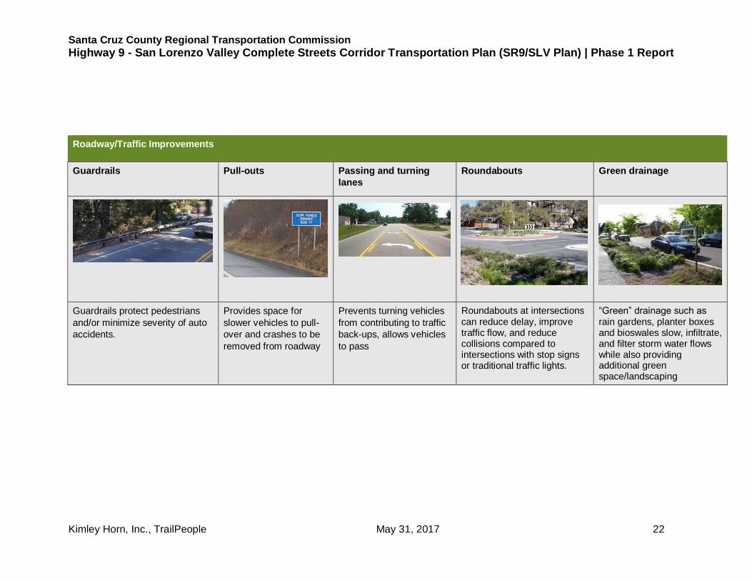
Roadway/Traffic Improvements
Guardrails Pull-outs Passing and turning
lanes
Roundabouts Green drainage
Guardrails protect pedestrians
and/or minimize severity of auto
accidents.
Provides space for
slower vehicles to pull-
over and crashes to be
removed from roadway
Prevents turning vehicles
from contributing to traffic
back-ups, allows vehicles
to pass
Roundabouts at intersections can reduce delay, improve traffic flow, and reduce collisions compared to intersections with stop signs or traditional traffic lights.
“Green” drainage such as rain gardens, planter boxes and bioswales slow, infiltrate, and filter storm water flows while also providing additional green space/landscaping

Santa Cruz County Regional Transportation Commission
Highway 9 - San Lorenzo Valley Complete Streets Corridor Transportation Plan (SR9/SLV Plan) | Phase 1 Report
Kimley Horn, Inc., TrailPeople May 31, 2017 23
Pedestrian Facilities
Shared bike/ped space
Grade-separated path Conventional sidewalk Trails Crosswalk with controls
Paved multiuse path.
(requires at least 10')
Pedestrian path built above or below retaining wall
Conventional concrete
sidewalks with curbs
Informal paths separated from roadways.
Crosswalks with flashing lights alerting drivers when pedestrians are in the crosswalk.

Santa Cruz County Regional Transportation Commission
Highway 9 - San Lorenzo Valley Complete Streets Corridor Transportation Plan (SR9/SLV Plan) | Phase 1 Report
Kimley Horn, Inc., TrailPeople May 31, 2017 24
Bicycle Facilities
Bike lane Green bike lane Buffered bike lane Cycle track
A minimum of 4’ wide, 5’ – 6’
desirable
Green bike lanes or green-backed sharrows further accentuate bike space
Buffer provides space between bicyclists and passing cars and/or “dooring” from parked cars
Bi-directional “Cycle track” on one
side of road, buffered from vehicle
lane

Santa Cruz County Regional Transportation Commission
Highway 9 - San Lorenzo Valley Complete Streets Corridor Transportation Plan (SR9/SLV Plan) | Phase 1 Report
Kimley Horn, Inc., TrailPeople May 31, 2017 25
Transit, Other
Transit Bus service Park and ride/carpool Parking Wayfinding signs
Improved transit stops with shelters
More frequent bus service in
SLV
Designates locations
and parking to support
commuter and other
carpooling
Parking that avoids backing into
the highway and/or bike and
pedestrian space.
Signage must be well organized, visible, and compliant with the Manual of Uniform Traffic Control Devices.

Santa Cruz County Regional Transportation Commission
Highway 9 - San Lorenzo Valley Complete Streets Corridor Transportation Plan (SR9/SLV Plan) | Phase 1 Report
Kimley Horn, Inc., TrailPeople May 31, 2017 26
Traffic Calming
Narrowed Lanes Higher visibility
crosswalk
Bulb out Colored Crossings Reduce Speeding
Narrowing lanes from 12’ to
11’ can slow down traffic
and provide more space for
other modes
Raised crosswalks,
decorative crosswalk to
slow cars in town centers
and near schools (allowed
on county roads, may not
be possible on Hwy 9)
Curb “bulb outs” reduce the crossing distance for pedestrians; reduced curve radius can be a potential challenge for trucks
Decorative paved crosswalks can slow traffic and emphasize walking areas
Increase CHP presence and enforcement of speed limits

Santa Cruz County Regional Transportation Commission
Highway 9 - San Lorenzo Valley Complete Streets Corridor Transportation Plan (SR9/SLV Plan) | Phase 1 Report
Kimley Horn, Inc., TrailPeople May 31, 2017 27
5. Site-Specific Improvement Concepts and Alternatives
This Phase 1 report attempts to pick up where prior studies, plans and public input left off. The objective of the current public
participation process is to obtain comments and preferences regarding these previously-submitted ideas; get additional ideas, and
use this input to develop alternative projects and concepts that respond to community needs and preferences, as well as the
standards and constraints of Caltrans, Metro Transit, funding opportunities, and other practical considerations.
A series of site-specific concepts for improving bicycle and pedestrian connectivity, parking organization, and overall traffic safety
was prepared based on ideas from cumulative public and agency input. These ideas get quite detailed in order to present realistic
scenarios to address some significant specific barriers and challenges, but they are only in the conceptual stage – not proposals, let
alone plans. Some of the concepts have only one solution idea – others have alternative or additive ideas to consider for the same
challenge area.
On-line surveys and in-person outreach is intended to collect input and preferences about these ideas. Informed input depends on
reviewing this report to understand the conditions, concepts, and considerations. Based on survey results and individual public and
agency comments, these improvement concepts will be defined, refined, and evaluated and other concepts identified by the
community in Phase 1 will be evaluated as part of Study Phase 2.

Santa Cruz County Regional Transportation Commission
Highway 9 - San Lorenzo Valley Complete Streets Corridor Transportation Plan (SR9/SLV Plan) | Phase 1 Report
Kimley Horn, Inc., TrailPeople May 31, 2017 28
1. Improved bicycle and pedestrian connection – Henry Cowell State Park to Felton Conditions/Challenges This section of highway is generally flat and has relatively gentle curves. The south half is suburban residential with some commercial and a church. The northern half is in the Felton commercial district. Significant constraints occur only at the southern part. From the end of the central commercial district at Kirby Street there are wide (approximately 8’) paved/gravel shoulders and some sections of sidewalk. Ladd’s Auto Body has a similar pull-in parking configuration to downtown. South of Laurel Drive the shoulder diminishes to 4 feet or less. There is a crosswalk at Redwood Drive near the entrance to the state park, but there is no signal or lights. Improvement Idea
Add minimum 4’ shoulders/bike Lanes with path on east side (Survey option 1):.
The SLV Trail Study proposed widening shoulders to at least 4’ where they are currently
less, and adding a path on the east side to the Big Trees Road/park entrance.3
Part of the shoulder widening could potentially be accomplished by narrowing lanes from
12’ to 11’ Adding a sidewalk or path on the east. would require extending large box
culverts/bridges at PM 5.55 and 5.8 and some minor grading. Barriers such as utility poles,
signs, drainage ditches, trees, and driveways would have to be addressed.
The crosswalk at Redwood Drive could be improved with lighting and a user-activated warning light (RRFB). Pros: would improve bicyclist and pedestrian safety from downtown south to the park.
Cons: moderately expensive.
3 This suggestion was also put forth by resident advocates.
South of downtown Felton
Looking north near state park

Santa Cruz County Regional Transportation Commission
Highway 9 - San Lorenzo Valley Complete Streets Corridor Transportation Plan (SR9/SLV Plan) | Phase 1 Report
Kimley Horn, Inc., TrailPeople May 31, 2017 29
Add path on east
Widen shoulders to at least 4’
Improve existing crosswalk at
Redwood Drive
Figure 5: Bicycle and pedestrian Improvements from Henry Cowell State Park to Felton

Santa Cruz County Regional Transportation Commission
Highway 9 - San Lorenzo Valley Complete Streets Corridor Transportation Plan (SR9/SLV Plan) | Phase 1 Report
Kimley Horn, Inc., TrailPeople May 31, 2017 30
2. More organized parking/frontage in downtown Felton
Conditions/Challenges
In the commercial area between Graham Hill Road and Kirby Street much of the parking is perpendicular, requiring backing into the
highway, which does not meet Caltrans standards and would not be allowed if it was not “grandfathered.” This configuration leaves
no safe designated space for bicyclists and pedestrians in the right-of-way, and tends to create an aesthetically unappealing
frontage. The right-of-way (ROW) line is generally at the edge of the existing roadway on the west – the parking is on private
property, but on the east the parking is in the ROW and the businesses generally have other parking lots.
Alternative Improvement Ideas
a. Convert to 45-degree angled parking, improve walkways at store fronts; add center turn lane (Survey option 2). The
Felton Town Plan proposed 45-degree angled parking with a back-up aisle that occupies the space where the sidewalk and bike lane
would normally be. It includes improved, more continuous sidewalks along the building frontages, and a 2-way left turn lane in the
center.
Figure 6: Highway 9 pedestrian improvements from Felton Town Plan

Santa Cruz County Regional Transportation Commission
Highway 9 - San Lorenzo Valley Complete Streets Corridor Transportation Plan (SR9/SLV Plan) | Phase 1 Report
Kimley Horn, Inc., TrailPeople May 31, 2017 31
Pros: Maintains existing storefront parking spaces while providing improved pedestrian facilities; provides some additional greenery
in the medians; easier to turn into and pull out of specific businesses.
Cons: Does not meet Caltrans standards and could not be funded with transportation grants. Provides no dedicated space for
bicyclists. Requires coordination with/between business/property owners.
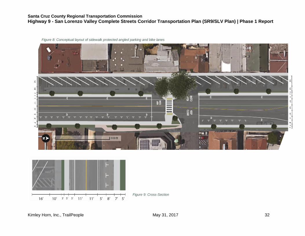
b. Convert to separated 30 degree angled parking or conventional
parallel parking with sidewalks in ROW (Survey option 3). Where there
is at least 35 feet of space from the white lane stripe or “fog line” the parking
could be reorganized to have consolidated entrances, and exits with 30-
degree angled parking. A sidewalk could be constructed, separated from
the parking by a narrow potentially landscaped median. Where there is less
space, the parking would have to be parallel.
Pros: Maintains existing storefront parking spaces while allowing for protected bicycle and pedestrian facilities; improved traffic
circulation; better aesthetics and green space.
Cons: Requires coordination with/between business/property owners. Existing pull in parking on west side is on private property and
not within Caltrans right-of-way, requires negotiation and coordination with businesses and property owners to plan improvements.
Figure 7: Sample layout of angled parking
Santa Cruz County Regional Transportation Commission
Highway 9 - San Lorenzo Valley Complete Streets Corridor Transportation Plan (SR9/SLV Plan) | Phase 1 Report
Kimley Horn, Inc., TrailPeople May 31, 2017 32
Figure 9: Cross-Section
Figure 8: Conceptual layout of sidewalk protected angled parking and bike lanes

Santa Cruz County Regional Transportation Commission
Highway 9 - San Lorenzo Valley Complete Streets Corridor Transportation Plan (SR9/SLV Plan) | Phase 1 Report
Kimley Horn, Inc., TrailPeople May 31, 2017 33
c. Colored/textured shoulders. A colored and textured
shoulder has been used in similar settings to define a
clearer zone for pedestrians and bicyclists. This would be a
less intense treatment option that would designate the
pedestrian space, and alert drivers to the presence of
pedestrians.
Pros: Avoids interfering with private property and existing
parking; relatively low cost. Can be done within Caltrans
ROW.
Cons: Does not address traffic safety issue and non-
compliance with current standards. Does not separate
pedestrians and bicyclists from cars as much as other
options.
Textured shoulders used by pedestrians in Capay Valley, CA
Textured shoulders with pull-in parking in Capay Valley, CA

Santa Cruz County Regional Transportation Commission
Highway 9 - San Lorenzo Valley Complete Streets Corridor Transportation Plan (SR9/SLV Plan) | Phase 1 Report
Kimley Horn, Inc., TrailPeople May 31, 2017 34
3. Bicycle and pedestrian access at Graham Hill Road intersection
Conditions/Challenges
This corner has no formal bike or pedestrian facilities and little to no space except by walking or biking through the adjacent gas
stations/repair shop parking lots. The lack of consolidated driveways exacerbates this condition. There is a redwood tree in a rock
planter in the ROW on Graham Hill that occupies the space where the shoulder and sidewalk would otherwise be. There is little to no
available ROW to add
shoulder or sidewalk.
Aerial of northwest corner of Graham Hill Road and Highway 9 and insets showing potential path/sidewalk

Santa Cruz County Regional Transportation Commission
Highway 9 - San Lorenzo Valley Complete Streets Corridor Transportation Plan (SR9/SLV Plan) | Phase 1 Report
Kimley Horn, Inc., TrailPeople May 31, 2017 35
Alternative Improvement Ideas
a. Narrow the lanes to add space for bikes on the shoulder and a continuous sidewalk (Survey option 4). The existing lanes
are typically 12 feet. If they were narrowed to 11 there would be enough space to add a sidewalk without impacting the private
businesses, except by creating consolidated driveways. The redwood tree would still be a barrier - the walkway could potentially go
around the back of the tree while the additional space is used to create at least a 4 foot shoulder (there may or may not be enough
space in the ROW, or the tree and planter could be removed. Note that narrowing lanes on Highway 9 for this project conflicts with
narrowing them to add more bike/ped space on the west side - doing both may require some ROW acquisition and additional impact
on adjacent businesses.
Pros: supports safer biking and walking in a congested area.
Cons: narrower lanes may bother some driver; impact on businesses;
moderate construction cost
b. Convert the intersection to a roundabout (Survey option 5). Roundabouts have been accepted by Caltrans as a prefered approach for
heavily used intersections. Roundabouts have been shown to move traffic
more efficiently with less delay than signalized intersections, and can be
designed to accommodate bicyclists and pedestrians safely and efficiently.
The space in the center is often used for community monument signs or
signature elements such as a sculpture
Pros: provides for more efficient traffic flow, provides more space for
bicyclists and pedestrians, provides opportunity for landmark feature.
Cons: may not fit in available area, expensive, disruptive during
construction, some people are uncomfortable with the concept.

Santa Cruz County Regional Transportation Commission
Highway 9 - San Lorenzo Valley Complete Streets Corridor Transportation Plan (SR9/SLV Plan) | Phase 1 Report
Kimley Horn, Inc., TrailPeople May 31, 2017 36
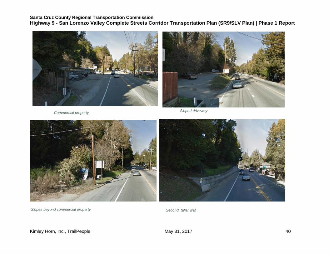
4. Bicycle and pedestrian connection to SLV schools from central Felton
Conditions/Challenges
The section of Highway 9 between Graham Hill Road/Empire Grade and
the SLV schools complex currently includes a series of retaining walls that
leave minimal space for bicyclists or pedestrians on the west side, and
little space on the east side near Graham Hill Road. This is a very
constrained section for bicyclist and pedestrian access in a location with
high demand and relatively heavy traffic. Because the schools are on the
west side, that is the most desirable alignment for access improvements.
The constraints change in a number of ways along this stretch, but the
primary challenges are a series of retaining walls on the west side in the
central and southern portions of this section. In the central portion tall
retaining walks have only approximately 4’ shoulders at the base. Near
the southern end a few residential properties on the west have steep
driveways and tall retaining walls with as little as 2 feet of shoulder space.
The roadway in this section is approximately 43 feet wide, which leaves
ample room for bike and pedestrian space if there are only 2 lanes, but
there is a left turn lane at the north end of the largest wall, and at the south end the road widens into 4 lanes, including 2 southbound
left turn lanes. Narrowing lanes would not provide enough space to create a separate pedestrian facility.
On the east side the commercial and residential properties toward the south end have driveways dropping down, and to the north the
mostly residential properties have low retaining walls. The 1/3 mile from Clearview Place north to the schools has some constraints
– slopes, trees, and landscaping in the ROW, but is relatively unconstrained compared to the section to the south.
Figure 11 details the structures along the west side from Felton Empire Road/Graham Hill Road north to Clearview Place/San
Lorenzo Way.
Children walking along highway 9 north of Felton

Santa Cruz County Regional Transportation Commission
Highway 9 - San Lorenzo Valley Complete Streets Corridor Transportation Plan (SR9/SLV Plan) | Phase 1 Report
Kimley Horn, Inc., TrailPeople May 31, 2017 37
NORTH
Figure 10: SLV Schools to Felton Corridor

Santa Cruz County Regional Transportation Commission
Highway 9 - San Lorenzo Valley Complete Streets Corridor Transportation Plan (SR9/SLV Plan) | Phase 1 Report
Kimley Horn, Inc., TrailPeople May 31, 2017 38
Figure 11: Constrains on west side of SR 9
NORTH
NORTH

Santa Cruz County Regional Transportation Commission
Highway 9 - San Lorenzo Valley Complete Streets Corridor Transportation Plan (SR9/SLV Plan) | Phase 1 Report
Kimley Horn, Inc., TrailPeople May 31, 2017 39
Wall at apartment building Walls at single family residences
Walls at single family residences Lower retaining wall
Santa Cruz County Regional Transportation Commission
Highway 9 - San Lorenzo Valley Complete Streets Corridor Transportation Plan (SR9/SLV Plan) | Phase 1 Report
Kimley Horn, Inc., TrailPeople May 31, 2017 40
Commercial property Sloped driveway
Slopes beyond commercial property Second, taller wall

Santa Cruz County Regional Transportation Commission
Highway 9 - San Lorenzo Valley Complete Streets Corridor Transportation Plan (SR9/SLV Plan) | Phase 1 Report
Kimley Horn, Inc., TrailPeople May 31, 2017 41
Taller wall End of wall at Clearview Place
North of Clearview Place At mobile home park

Santa Cruz County Regional Transportation Commission
Highway 9 - San Lorenzo Valley Complete Streets Corridor Transportation Plan (SR9/SLV Plan) | Phase 1 Report
Kimley Horn, Inc., TrailPeople May 31, 2017 42
Alternative Improvement Ideas
a. Separate Class I path on west side (Survey option 6). A path could
theoretically be constructed above the highway retaining wall, as illustrated in
Figure 12. The ROW line is approximately 12’ – 14’behind the walls. This would
require an additional low retaining wall, and extension walls may be needed to
climb and descend behind the wall at an ADA-compliant maximum 5% grade.
Completing the path south past the residential structures with walls may require
the acquisition and removal of some residential structures.
Constructing a Class I path or pedestrian path in the highway ROW on the west
side the remaining approximately 1/3 mile to the schools is constrained by
some slope and mature trees, but would be far more feasible/less expensive
than the portion to the south.
Pros: safest for bike/ped connection to schools.
Cons: Impacts private properties; likely very expensive.
b. Narrow lanes and add buffered bike (and pedestrian) lane on west
side (Survey option 7). While adding a separate path would get into
expensive acquisition and construction, if the lanes were narrowed from
present 12 feet to 11 feet and shifted to the east slightly a buffered bike lane
or shared bike/pedestrian lane at least 8’
Figure 12: Cross-section with path constructed above wall
Armadillo buffers Painted buffer Tall wall looking south

Santa Cruz County Regional Transportation Commission
Highway 9 - San Lorenzo Valley Complete Streets Corridor Transportation Plan (SR9/SLV Plan) | Phase 1 Report
Kimley Horn, Inc., TrailPeople May 31, 2017 43
wide could be provided on the west side for most of the way – portions at the north and south ends of the wall sections may still
require some reconstruction to get the necessary space. To remind/deter drivers from crossing into the bike/ped lane, “rumble strips”
or raised “armadillos” could be installed.
Pros: safer for bikes and pedestrians than current condition; far less expensive and more easily implemented than separate path;
narrower lanes often used to slow/calm traffic.
Cons: narrower lanes may bother some drivers, may not be acceptable to Caltrans depending on speed limits, etc.
c. Add sidewalk on east side. Adding a sidewalk on the east side may be feasible
independent of lane narrowing or shift. There are mailboxes, signs and other private
features in the public right-of-way that would have to be moved. The descending
driveways would make it difficult for the sidewalk to comply with ADA access standards
without reconstructing the driveways to be steeper – having the sidewalk slightly below
the level of the highway with a curb might help.
Pros: safer for pedestrians; far less expensive and more easily implemented than
separate path; don’t need to alter lanes.
Cons: not safer for bicyclists; school kids would have to cross 9 at least once, may
discourage use. Impacts private fixtures and driveways. Slopes, cost.
d. Cooper/Clearview/Fall Creek Bypass (Survey option 8). (no access
improvements). Cooper Street is a quiet residential street that parallels Hwy 9 to the
west. It connects to Hwy 9 via Clearview Place (now a private road with steep slope –
approximately 30% gradient) to the north of the segment with the retaining walls. This
would be a much safer alternative to walking along the shoulder of the highway. It is
closed to vehicles but physically open to bikes and pedestrians. In addition to this
connection to Highway 9 there is a longer route via Fall Creek Road that some kids use
to reach the back of the schools.
Pros: a safer alternative for walking or biking than continuing along the highway.
Cooper Street
Existing shoulder on east side, site of potential sidewalk

Santa Cruz County Regional Transportation Commission
Highway 9 - San Lorenzo Valley Complete Streets Corridor Transportation Plan (SR9/SLV Plan) | Phase 1 Report
Kimley Horn, Inc., TrailPeople May 31, 2017 44
Cons: formal legal access or improved gradients on Clearview Place would may require an easement or re-acquisition of the
roadway; channeling significant bike and pedestrian traffic may be objectionable to the residential neighborhood; the route is longer
than the highway – particularly the Fall Creek Road connection, and some kids may not use it
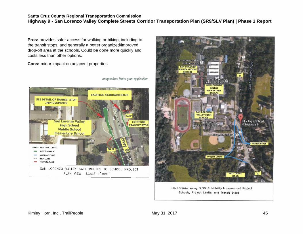
5. Transit and sidewalk access improvements SLV school
entrance to Fall Creek Drive (Survey option 9).
Conditions/Challenges
The entrance to the SLV schools is not fully improved for bicycle and
pedestrian access, including to the transit stops. Kids must walk or bike on
the shoulders or in the dirt or mud, and the relationship of the transit stop
to vehicle drop-off is awkward.
Improvement Idea
The proposed improvements include a relocated and improved bus stop
shelter on the west side, sidewalks and paving around that shelter and
connecting from the shelter on the east side to the crosswalk, and
extension of a sidewalk on the west side to south of Fall Creek Drive.
Iimages from Metro grant application
Santa Cruz County Regional Transportation Commission
Highway 9 - San Lorenzo Valley Complete Streets Corridor Transportation Plan (SR9/SLV Plan) | Phase 1 Report
Kimley Horn, Inc., TrailPeople May 31, 2017 45
Pros: provides safer access for walking or biking, including to
the transit stops, and generally a better organized/improved
drop-off area at the schools. Could be done more quickly and
costs less than other options.
Cons: minor impact on adjacent properties
Images from Metro grant application

Santa Cruz County Regional Transportation Commission
Highway 9 - San Lorenzo Valley Complete Streets Corridor Transportation Plan (SR9/SLV Plan) | Phase 1 Report
Kimley Horn, Inc., TrailPeople May 31, 2017 46
6. Improved bicycle and pedestrian connection from schools north to El Solyo Heights Drive
Conditions/Challenges
Along the west side of Highway 9 north of San Lorenzo Valley Middle School a series
of retaining walls in the ROW present a major constraint for extending a path or
sidewalk. The shoulder is approximately 8’ wide at the south end of the walls, but
narrows to approximately 3 feet at the north end. There is not sufficient lane or shoulder
width to create space for a path. Given the proximity to the schools, and heavy, fast
traffic in this vicinity, access improvements would be highly desirable. The stretch of
constrained roadway only extends along the frontage of four residential properties; to
the north and south there are few constraints to adding a sidepath. North of El Solyo
Heights Drive there are no roads or structures fronting Highway 9 for about 1,800 feet,
so there is less need for access improvements.
As shown in Figure 13, based on Caltrans record drawings, the wall is a substantial
structure supported by deep piers. The top of the wall is approximately 7.5’ above the
roadway, and the ROW line is approximately 8 feet behind the wall.
Alternative Improvement Ideas
a. Add a sidewalk or path on west side above/behind the existing retaining
walls (Survey option 10). The path could be constructed behind the existing wall
and barrier, with the addition of a low retaining wall and fence as shown in Figure 13.
The path would need to descend and climb to/from the intersecting driveways at a
maximum 5% gradient to comply with ADA standards. This would be accomplished
by the added retaining walls.
Ideally the 12’ lanes would be narrowed to 11’ to add space for bicyclists at the
current “pinch point.”
Pros: Access for pedestrians to the schools as well as to other destinations would be
improved, and potentially access for southbound bicyclists.
Cons: Would reduce the yard area of existing residences; relatively expensive to implement.
Figure 13: Cross-section of path above wall
Existing wall, looking north

Santa Cruz County Regional Transportation Commission
Highway 9 - San Lorenzo Valley Complete Streets Corridor Transportation Plan (SR9/SLV Plan) | Phase 1 Report
Kimley Horn, Inc., TrailPeople May 31, 2017 47
b. Bypass via El Solyo Heights Drive/Hacienda Way (Survey option 11). A
bypass already exists for Middle School students (and potentially other students) in
the form of an informal path leading to a small wooden bridge over a drainage, and
connecting to Hacienda Way, near the northeast corner of the school grounds.
Improving the bridge and constructing a formal multi-use path would involve
construction on school property, but would be outside the fenced school yard, in an
area with moderate slopes.
The connection back to Highway 9 via
Hacienda Way and El Solyo Heights Drive
could be improved by providing route signs
and minor frontage improvements. A potential
disadvantage is that it would be inappropriate
to invite the public to use a route that crosses
school property. This bypass would be for
school access only – not for through public
access.
Pros: The improvements would be relatively
inexpensive to construct.
Cons: This is really formalizing a route that
exists – it would only be useful for school
students and would not improve conditions for
bicyclists and pedestrians who are not
headed to the schools
Figure 14: Connection from SLV Schools North
Hacienda Way

Santa Cruz County Regional Transportation Commission
Highway 9 - San Lorenzo Valley Complete Streets Corridor Transportation Plan (SR9/SLV Plan) | Phase 1 Report
Kimley Horn, Inc., TrailPeople May 31, 2017 48
7. Crossing and Pedestrian Improvements at/to Mill Street/Highway 9 in Ben Lomond (Survey option 12).
Conditions/Challenges
Along Mill Street from the post office to Highway 9 and
along Glen Arbor east to Pine Street (a populous residential
area) there is no walking area and pedestrians of all ages
must contend with cars, trucks and buses by walking in the
roadways. In the winter both of these streets have
significant runoff and there really is no place to walk safely. Also, Main Street at SR 9 is a wide intersection with long crossing
times and frequently heavy, fast traffic. The curve limits sight
distance ahead.
Improvement Ideas
a. Add crosswalk warning lights and lighting at Highway. At
the Mill Street/Glen Arbor intersection add warning devices such
as in-pavement flasher to overhead beacons to actively alert
drivers to pedestrians crossing, install additional electrolier and
convert to LED lights on Route 9.
b. Add a walkway from Pine Street to Highway 9. Add a
formal walkway, with associated drainage improvements
on Glen Arbor Road connecting Highway 9 to Pine Street.
SR 9 at Mill Street intersection in Ben Lomond

Santa Cruz County Regional Transportation Commission
Highway 9 - San Lorenzo Valley Complete Streets Corridor Transportation Plan (SR9/SLV Plan) | Phase 1 Report
Kimley Horn, Inc., TrailPeople May 31, 2017 49
8. Pathway on SW side of SR 9 from Quality Inn/bridge south to Mill Street in Ben Lomond (Survey option 13)
Conditions/Challenges
There is a sidewalk and crosswalk at Mill Street but no formal pedestrian
facility north until the sidewalk on the bridge over the river. There are
private landscape improvements and several mature redwoods and firs at
or near the shoulder that block the normal location of a sidewalk, and pull-in
parking that would cross.
Improvement Idea
An informal paved path could wind behind or in front of the trees, assuming
there is room in the highway ROW, to avoid or minimize tree removal. This
situation is similar to many locations in SLV where mature trees and private
landscaping or other features occupy what would otherwise be the
pedestrian space
.Pros: would provide safer pedestrian access
Cons: would impact private improvements in the ROW and
potentially mature trees
Existing shoulder between Mill Street road and Quality Inn/bridge
Location of proposed pathway
Santa Cruz County Regional Transportation Commission
Highway 9 - San Lorenzo Valley Complete Streets Corridor Transportation Plan (SR9/SLV Plan) | Phase 1 Report
Kimley Horn, Inc., TrailPeople May 31, 2017 50
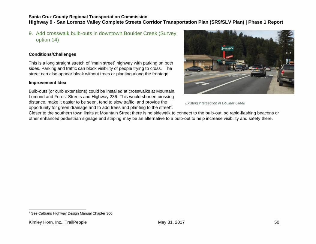
9. Add crosswalk bulb-outs in downtown Boulder Creek (Survey
option 14)
Conditions/Challenges
This is a long straight stretch of “main street” highway with parking on both
sides. Parking and traffic can block visibility of people trying to cross. The
street can also appear bleak without trees or planting along the frontage.
Improvement Idea
Bulb-outs (or curb extensions) could be installed at crosswalks at Mountain,
Lomond and Forest Streets and Highway 236. This would shorten crossing
distance, make it easier to be seen, tend to slow traffic, and provide the
opportunity for green drainage and to add trees and planting to the street4.
Closer to the southern town limits at Mountain Street there is no sidewalk to connect to the bulb-out, so rapid-flashing beacons or
other enhanced pedestrian signage and striping may be an alternative to a bulb-out to help increase visibility and safety there.
4 See Caltrans Highway Design Manual Chapter 300
Existing intersection in Boulder Creek

Santa Cruz County Regional Transportation Commission
Highway 9 - San Lorenzo Valley Complete Streets Corridor Transportation Plan (SR9/SLV Plan) | Phase 1 Report
Kimley Horn, Inc., TrailPeople May 31, 2017 51
Figure 15: Proposed bulb-out and pedestrian safety improvement locations

Santa Cruz County Regional Transportation Commission
Highway 9 - San Lorenzo Valley Complete Streets Corridor Transportation Plan (SR9/SLV Plan) | Phase 1 Report
Kimley Horn, Inc., TrailPeople May 31, 2017 52
Pros: decreases crossing distance and/or crossing visibility,
traffic calming, potential for green drainage and landscaping
Cons: potential limits or conflicts related to Caltrans standards
Example bulb-out
Caltrans bulb-out guidelines
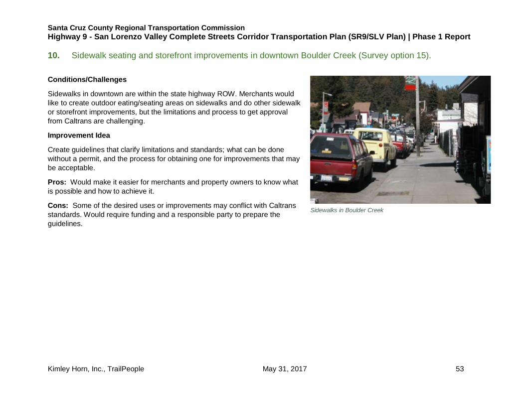
Santa Cruz County Regional Transportation Commission
Highway 9 - San Lorenzo Valley Complete Streets Corridor Transportation Plan (SR9/SLV Plan) | Phase 1 Report
Kimley Horn, Inc., TrailPeople May 31, 2017 53
10. Sidewalk seating and storefront improvements in downtown Boulder Creek (Survey option 15).
Conditions/Challenges
Sidewalks in downtown are within the state highway ROW. Merchants would
like to create outdoor eating/seating areas on sidewalks and do other sidewalk
or storefront improvements, but the limitations and process to get approval
from Caltrans are challenging.
Improvement Idea
Create guidelines that clarify limitations and standards; what can be done
without a permit, and the process for obtaining one for improvements that may
be acceptable.
Pros: Would make it easier for merchants and property owners to know what
is possible and how to achieve it.
Cons: Some of the desired uses or improvements may conflict with Caltrans
standards. Would require funding and a responsible party to prepare the
guidelines.
Sidewalks in Boulder Creek

Santa Cruz County Regional Transportation Commission
Highway 9 - San Lorenzo Valley Complete Streets Corridor Transportation Plan (SR9/SLV Plan) | Phase 1 Report
Kimley Horn, Inc., TrailPeople May 31, 2017 54
Figure 16: As-builts for Highway 9 in Boulder Creek