Embed Size (px)
Citation preview

PHASE I AND PHASE II GEO-ENVIRONMENTAL SITE INVESTIGATION Jefferson Park Whitehaven Cumbria CA28 9HE E3P Report: 10365-r1 Issued: January 2014 Prepared for
R. G. Parkins & Partners Ltd Jefferson Park January 2015
Ref: 10-365r1 Page 1 of 34
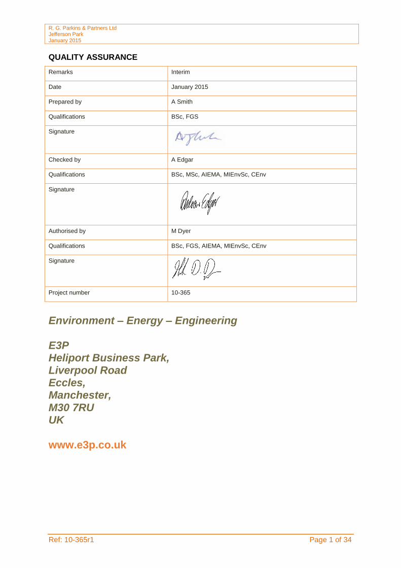
QUALITY ASSURANCE
Environment – Energy – Engineering E3P Heliport Business Park, Liverpool Road Eccles, Manchester, M30 7RU UK www.e3p.co.uk
Remarks Interim
Date January 2015
Prepared by A Smith
Qualifications BSc, FGS
Signature
Checked by A Edgar
Qualifications BSc, MSc, AIEMA, MIEnvSc, CEnv
Signature
Authorised by M Dyer
Qualifications BSc, FGS, AIEMA, MIEnvSc, CEnv
Signature
Project number 10-365

R. G. Parkins & Partners Ltd Jefferson Park January 2015
Ref: 10-365r1 Page 2 of 34
EXECUTIVE SUMMARY
Site Address Jefferson Park, Whitehaven, Cumbria CA28 9HE
Grid Reference E297420, N516800
Site Area 0.32 Ha
Current Site Use
The subject site is an irregular shaped parcel of land located to the west of Low Road, approximately 1.6km south of Whitehaven town centre. The site comprises grassed areas within a partly developed residential estate. A number of residential dwellings are located within the wider site to the north and south of the proposed development.
Environmental Setting
Geology – Glacial Till (Diamicton) overlying Penning Middle Coal Measure Formation (Mudstone, Siltstone and Sandstone). Aquifers – The drift and solid geology aquifers are classified Secondary A. There are no groundwater abstractions within a 1km radius of the site; Sensitive Land uses – Residential dwellings within close proximity; Hydrology – An unnamed surface watercourse is located within influencing distance of the site (<10m); Ecology – No risk to ecology has been identified. Flooding – The site is not located within a currently defined fluvial flood risk zone.
Previous Reports E3P has been provided with a Ground Investigation Report by Sub-Surface (NW) Ltd, dated July 2007 (Ref: Report No. 4901). E3P has undertaken a review of this report, with the pertinent points included herein.
Site History
Historical maps indicate that the site has been utilised for industrial purposes since the earliest available maps (circa 1879) and later developed. The site was actively excavated initially as a Brick Field associated with the nearby Fire Clay Brickworks until the construction of a Laundry (circa 1925) across the southern profile of the site. It would later appear the previously excavated areas have been infilled and a Refuse Tip extended into the northwest sector of the site. More recently (post 1994) the site was cleared of all structures and a highway constructed associated with the wider Jefferson Park residential development
Landfill Sites & Ground Gases
A Local Authority recorded landfill site and licensed waste management facility (Woodhouse Quarry) is located 230m southwest of the site; the boundary of which extended to within 43m of the subject site may be a potential source of hazardous ground gas. Additionally the underlying coal measures and areas of in-filled ground across the site may also represent a source of ground gas.
Radon Unaffected – no special precautions required.
Coal Mining / Land Stability
The site is affected by coal mining and is within the zone of influence for historic mine workings. A mine Adit and two shafts are located in close proximity to the site and it is believed shallow workings for which the coal authority has no knowledge are likely to be present. Based on this information it is considered that a full assessment in due consideration of the requirements of CIRIA 32 and the Coal Authority Permissions Process is required to assess future stability issues.
Intrusive Ground Investigation
Ground Conditions
Made Ground Made Ground deposits generally comprise a sandy and/or gravelly clay of brick, ash, concrete, clinker and timber fragments underlain by a clayey sandy gravel or gravelly sand of mixed lithology to a maximum proven depth of 6.90m bgl in the northeast quadrant of the site. Drift Deposits Natural deposits predominantly comprise firm becoming very stiff at depth gravelly and/or sandy CLAY with cobbles of sub-rounded sandstone to a maximum proven depth of 10.10m bgl.

R. G. Parkins & Partners Ltd Jefferson Park January 2015
Ref: 10-365r1 Page 3 of 34
Executive Summary Continued
Ground Conditions
Solid Geology Solid geology of COAL was encountered within BH2 at 10.10m bgl. Groundwater Groundwater was encountered at two locations as water strikes at 7.5m bgl (BH1) and 6.90m bgl (BH2).
Tier 1 Contaminated Land Risk Assessment
Human Health
The Tier 1 human health risk assessment identified elevated concentrations of benzo(a)anthracene, lead and arsenic which exceed the GAC values within the near surface soils. In addition, asbestos was encountered in a number of Made Ground samples from across the proposed development. E3P considers the shallow Made Ground will not be suitable for use as Topsoil within any proposed gardens or landscaped areas due to the presence of asbestos containing material identified across the entire site and localised elevated PAH and heavy metal compounds. Therefore E3P recommends that a cover system be provided to garden and landscaped areas, thereby removing any dermal contact/ingestion pathways and the risk to the identified receptors.
Controlled Waters
The Tier 1 controlled water assessment has not identified any potential source, pathway or viable receptor. Therefore, given the absence of any potentially complete pollutant linkage the site is determined to pose no unacceptable level of risk to controlled waters and the wider environ.
Ground Gas
Monitoring to date has not identified any elevated concentrations of methane or carbon dioxide. Given the identified ground conditions and available results, E3P considers that further monitoring is likely to show a low risk to end users and that gas precautions will not be required.
Potable Water Infrastructure
Chemical analysis suggests that Polyethylene (PE) pipeline will be suitable for the proposed residential development.
Geotechnical Assessment
Underground Obstructions
The site has been the subject to previous development and industrial processes associated with shallow mining and clay extraction and as such further buried structures and obstructions are anticipated.
Remediation / Enabling Works
Relict obstructions are anticipated and as such a programme of enabling works will be required to clear all proposed foundation and infrastructure excavations of obstructions and cut and fill the site to level. All works should be completed in accordance with a suitable geotechnical engineering specification and in accordance with the relevant environmental permits.
Foundation Options
The Made Ground is not considered suitable bearing stratum to support a shallow foundation due to the unquantified potential for long term differential and total settlement.
It is considered the proposed foundations could be supported using vibro replacement granular stone columns to facilitate the use of shallow (re-enforced) strip foundations within the treated Made Ground.
Alternatively, structural loading could be transferred to the deep natural drift deposits though a driven pile foundation to be designed by a specialist contractor and the Structural Engineer.
Soak-away Drainage
It is considered the predominantly cohesive soils matrix underlying the Made Ground is unlikely to provide a high degree of soakage potential for drainage systems in this instance.
Sulphate Assessment
Design Sulphate Class DS-1, AC-1s.
Executive Summary Continued

R. G. Parkins & Partners Ltd Jefferson Park January 2015
Ref: 10-365r1 Page 4 of 34
Infrastructure & CBR Design %
The Made Ground and shallow clay soils can be re-engineered to facilitate the construction of a suitable sub-grade to provide a CBR design % in excess of 5 for new highways and infrastructure, subject to the completion of works during favourable climatic conditions.
Waste Soils
Due to the presence of asbestos fibres, inorganic heavy metals and sulphates within the Made Ground, soils would be classified as Stable Non-Reactive (Non Hazardous) once sorted and analysed.
Recommendations
Based on the initial Geo-Environmental Assessment, E3P recommend the following works:
Further investigation utilising Rotary boreholes to determine the presence of shallow mine workings and/or stabilisation by drilling and grouting beneath proposed buildings;
Further investigation and detailed quantitative risk assessment to determine the concentrations of asbestos within the impacted made ground and inform the production of a detailed Remediation Strategy that will ensure the mitigation of risk to all identified receptors;
Plot specific Foundation Zoning Plan to be prepared by the Structural Engineer;
Geotechnical earthworks strategy to define the re-compaction criteria for the engineering of the sub-grade to support adopted infrastructure;
CL:AIRE Materials Management Plan (MMP) to ensure the economic and legislatively complaint
re-use of soils; and,
Preparation of an overarching Remediation & Enabling Works strategy and build phase mitigation plan to ensure the safe and legislatively compliant management of materials and construction of the proposed dwellings in a manner that will ensure no risk to the critical receptors.
In the event that any previously unidentified potential contaminants of concern are identified during the ground works, an appropriately qualified consultant should be contacted at the first available opportunity to ensure any issue is dealt with in the appropriate manner.

R. G. Parkins & Partners Ltd Jefferson Park January 2015
Ref: 10-365r1 Page 5 of 34
TABLE OF CONTENTS
EXECUTIVE SUMMARY 2
TABLE OF CONTENTS 5
1.0 INTRODUCTION 7
1.1 Background 7 1.2 Proposed Development 7 1.3 Objectives 7 1.4 Limitations 7 1.5 Previous Reports 8 1.6 Confidentiality 8 1.7 Risk Classification 8
2.0 PREVIOUS REPORTS 9
2.1 Desk Study Information 9
3.0 SITE SETTING 10
3.1 Site Details 10 3.2 Current Site Use 10 3.3 Surrounding Area 11
4.0 SITE HISTORY 12
4.1 On-Site Historical Development 12 4.2 Off-Site Historical Development 14 4.3 Planning History 14
5.0 ENVIRONMENTAL SETTING 15
5.1 Geology & Hydrogeology 15 5.2 Geotechnical Data 15 5.3 Coal Mining 15 5.6 Industrial Land Uses 17 5.7 Sensitive Land Uses 17
6.0 CONSULTATIONS 18
6.1 Local Authority Contaminated Land and Building Control Officer 18 6.2 Landfill Sites and Waste Treatment Sites 18 6.3 Regulatory Database 19
7.0 INITIAL CONCEPTUAL SITE MODEL (CSM) 20
7.1 Initial CSM 20
8.0 INTRUSIVE GROUND INVESTIGATION 21
8.1 General 21 8.2 In-Situ Standard Penetration Testing (SPT) 21 8.3 Laboratory Analysis 21
9.0 GROUND AND GROUNDWATER CONDITIONS 23
9.1 Ground Conditions 23 9.1.1 Summary of Ground Conditions 23 9.1.2 Made Ground 23 9.1.3 Drift Deposits 24 9.1.4 Solid Geology 24 9.1.5 Side Stability and Ease of Excavation 24 9.1.6 Soil Plasticity 27 9.1.7 pH and Sulphate 27

R. G. Parkins & Partners Ltd Jefferson Park January 2015
Ref: 10-365r1 Page 6 of 34
9.1.8 Groundwater Conditions 27 9.2 Ground Gas 27
10.0 TIER 1 QUALITATIVE CONTAMINATED LAND RISK ASSESSMENT 30
10.1 Human Health Risk Assessment 30 10.2 Controlled Waters Risk Assessment 33 10.3 Ground Gas Risk Assessment 35 10.4 Conceptual Model 35
11.0 GEOTECHNICAL ASSESSMENT 36
11.1 Summary of Ground Conditions 36 11.2 Site Preparation 36 11.3 Foundation Conditions and Bearing Capacity 37 11.4 Ground Floor Slabs 37 11.5 Pavement Construction 38 11.6 Drainage 38 11.7 Concrete Durability 38 11.8 Excavations 38 11.9 Minerals 38 11.10 Further Works 38 11.10 Construction Activity and Inspection 39
12.0 CONCLUSIONS & RECOMMENDATIONS 40
APPENDICES Appendix I Limitations Appendix II Glossary Appendix III Drawings
Drawing 10365-001 Site Location Plan Drawing 10365-002 Current Site Layout
Drawing 10365-003 Proposed Development Plan Drawing 10365-004 Historical Features Plan
Drawing 10365-005 Exploratory Hole Location Plan Drawing 10365-006 Depth of Made Ground Plan Drawing 10365-007 Mine Abandonment Plan Drawing 10365-008 Geological Plan Appendix IV Photographs Appendix V Historical Maps Appendix VI E3P Exploratory Hole Logs Appendix VII Chemical Testing Results Appendix VIII Origin of Tier I Generic Assessment Criteria Appendix IX Geotechnical Testing Results

R. G. Parkins & Partners Ltd Jefferson Park January 2015
Ref: 10-365r1 Page 7 of 34
1.0 INTRODUCTION 1.1 Background E3P has been commissioned by R G. Parkins & Partners Ltd to undertake a Geo-Environmental Site Assessment of their site located on Jefferson Park, Whitehaven, Cumbria. This report is required to determine potential contaminated land and geotechnical liabilities associated with a future residential redevelopment.
The scope of work consisted of:
Detailed desk study;
Intrusive ground investigation comprising 13 No. trial pits, 3 No. cable percussive probeholes and 6 No. window sample probeholes, with 6 No. being completed as environmental monitoring installations;
Ground Gas Monitoring; and,
Interpretive Geo-Environmental Report. 1.2 Proposed Development The client intend to construct 16 No. low rise residential units with associated access roads, parking areas, landscaping and adopted drainage infrastructure at Jefferson Park, to the south of Whitehaven, Cumbria. A Proposed Development Plan (Drawing 10365-003) is included in Appendix III. 1.3 Objectives The objectives of the Geo-Environmental investigation are to:
Review historical plans, geology, mining, hydrogeology, site sensitivity, flood-plain issues, mining records and any local authority information available in order to complete a Desk Study in line with Environment Agency (EA) document Model Procedures for the Management of Contaminated Land (Contaminated Land Report 11 (CLR11));
Undertake a preliminary stage of sampling and analysis to provide an overview of
environmental issues identified;
Assess the implications of any potential environmental risks, liabilities and development constraints associated with the site in relation to the future use of the site and in relation to off-site receptors;
Assess the geotechnical information and provide preliminary recommendations in relation to foundations, pavement construction and floor slabs;
Provide an assessment of the soakage of the underlying soils to assist in the design of infiltration based SuDS.
Provide recommendations regarding future works required. 1.4 Limitations The limitations of this report are presented in Appendix I.

R. G. Parkins & Partners Ltd Jefferson Park January 2015
Ref: 10-365r1 Page 8 of 34
1.5 Previous Reports The following reports have previously been completed for the site: Sub Surface (NW) Ltd – Ground Investigation, Lowe Road, Whitehaven, Cumbria. Ref: Report No. 4901, dated July 2007. The pertinent points of the Sub Surface (NW) Ltd report have been included within Section 2.0 of this report. 1.6 Confidentiality E3P has prepared this report solely for the use of the Client and those parties with whom a warranty agreement has been executed, or with whom an assignment has been agreed. Should any third party wish to use or rely upon the contents of the report, written approval must be sought from E3P; a charge may be levied against such approval. 1.7 Risk Classification E3P has utilised the available data to classify the site on the basis of its likely contaminated land liability and potential for geotechnical constraints in relation to the site development. The risk classification definitions are summarised below:
Risk Definition
Low There are unlikely to be significant contaminated land liabilities/geotechnical constraints associated with the property.
Low-Moderate There are unlikely to be significant contaminated land liabilities/geotechnical constraints associated with the property with regard to the proposed use. However, minor issues may require further consideration in the event of a future redevelopment of the site etc.
Moderate Some potential contaminated land liabilities/geotechnical constraints are likely to affect the property as a result of historical and/or current activities. The risks identified are unlikely to pose an immediate significant issue but the purchaser/developer may wish to make further enquiries of the vendor or undertake further environmental improvements. Redevelopment of the site will likely require further site investigation.
Moderate-High Some potentially significant contaminated land liabilities/geotechnical constraints have been identified at the property that requires further assessment including intrusive ground investigations.
High Significant potential contaminated land liabilities/geotechnical constraints have been identified at the property. Further assessment including intrusive ground investigation will be required to determine to level of risk and associated liability.

R. G. Parkins & Partners Ltd Jefferson Park January 2015
Ref: 10-365r1 Page 9 of 34
2.0 PREVIOUS REPORTS 2.1 Desk Study Information Pertinent points from the previously completed Sub Surface (NW) Ltd Ground Investigation are as follows:
The subject site is approximately 1.2 Ha, located to the west of Low Road, about 1.6km to the south of the centre of Whitehaven, Cumbria bound to the east by Low Road, south by a cemetery, west by open land and north by a former railway corridor;
The site topography shows a steep gradient from Low Road through the eastern margin of the site and then more gently through the central sector. The site was formerly utilised by Lakeland Laundry and has now been largely cleared of buildings;
Up to 8.00m of Made Ground was encountered in the north east quadrant of the site and
up to 6.20m of Made Ground was encountered in the central western area of the site. An infilled east to west trending valley is apparently present in the northern area of the site. Made Ground generally comprised granular materials of ashy gravelly clayey silty sand inter-layered with cohesive deposits of gravelly to slightly gravelly slightly sandy clays;
Drift deposits generally comprised soft to stiff, becoming stiff to very stiff with depth
gravelly to slightly gravelly slightly sandy clays, with gravel of sandstone, siltstone, quartzite and occasional coal. Local cobbles and boulders were encountered;
Bedrock was encountered as very weak / weak highly weathered mudstone. Bedrock
with depth was found to be interbedded mudstone, siltstone and sandstone with limestone and a number of coal seams, some of which were found to have been mined;
Two mine shafts are present on the site and coal mine workings were found at a shallow
depth. Sub-surface found there to be an unacceptable risk of subsidence from shallow coal mining and recommended stabilisation by grouting. E3P has not received details of these stabilisation works;
Sub-Surface recommended foundations to be a combination of mass trench fill and
vibro stone columns to be used. E3P has not received details at this time of what foundations were adopted for the dwellings previously constructed;
Chemical laboratory analysis identified elevated arsenic, cadmium, lead, nickel,
benzene, benzo(a)pyrene and TPHs in addition to asbestos sheeting, however this is based on limited testing. A cover system was recommended as being a suitable form of remediation for the proposed residential development, along with localised hotspot remediation;
No elevated levels of methane have been detected. However, elevated concentrations
of carbon dioxide and/or depleted levels of associated oxygen have been recorded. Carbon dioxide in conjunction with depleted oxygen is an asphyxiant, therefore ground gas protection measures will be required for the proposed development;
Shallow mineworkings have been identified as voids, loss of flush and water inflow
primarily within the Bannock Coal; and
It should be noted the Sub-Surface report appears to be incomplete, with exploratory hole logs and exploratory hole location plans not included, thus limiting the quality of the information review;

R. G. Parkins & Partners Ltd Jefferson Park January 2015
Ref: 10-365r1 Page 10 of 34
3.0 SITE SETTING 3.1 Site Details
Site Address Jefferson Park, Whitehaven, Cumbria CA28 9HE
National Grid Reference E297420, N516800
Site Area 0.32 Ha
All acronyms used within this report are defined in the Glossary presented in Appendix II. A site location map is presented in Appendix III. 3.2 Current Site Use Site Description
Occupancy/use The subject site is an irregular shaped parcel of land, located to the west of Low Road, approximately 1.6km south of Whitehaven Town Centre comprising grassed areas within a partly developed residential estate. A number of residential dwellings are located within the wider area to the north and south of the proposed development.
Structures None identified.
Access Access is from Low Road to the east.
Slope A steep gradient through the eastern sector of the site extends from Low Road, becoming a gentle gradient rising through the centre of the site towards the western boundary.
Retaining structures
No retaining structures are apparent.
Surface Cover (%)
Buildings: 0
Hardstand: <15
Soft cover: 85
Trees None.
Hazardous Material Storage
There are no hazardous materials currently stored on site.
Asbestos Containing Material (ACM)
There is no visual evidence of ACM material located on site, however given that ACM was encountered during the Sub-Surface GI and the extensive Made Ground underlying the site, the presence of ACM is considered likely.
PCBs No equipment that may potentially containing PCBs was observed at the site.
Waste Storage No potentially hazardous waste streams are generated at the property.
Drainage A review of online sewer records shows that mains water sewers are located on Jefferson Park from Low Road to the east.

R. G. Parkins & Partners Ltd Jefferson Park January 2015
Ref: 10-365r1 Page 11 of 34
3.3 Surrounding Area The surrounding land uses are summarised below:
Direction Land Use
North Public Footpath (Former Railway)
East Low Road and Whitehaven Cemetery
South Whitehaven Cemetery
West Open Land (Former Quarry)

R. G. Parkins & Partners Ltd Jefferson Park January 2015
Ref: 10-365r1 Page 12 of 34
4.0 SITE HISTORY 4.1 On-Site Historical Development A review of historical mapping pertinent to the site is summarised in Table 4.1 below. In addition, historical site features are presented on Drawing 10365-004 (Appendix II). The potentially contaminative sources identified are highlighted in bold and the full historical maps included in Appendix III. Table 4.1 Summary of Potentially Contaminative Historical Land Uses
Map Edition
Historical Land Use Historical Map Excerpt
1879
1:2,500
The southern sector of the site is recorded as a Brick Field. An excavation is recorded through eastern sector running along the northern profile of the western sector. The northwest quadrant of the site is unspecified open land (possibly agricultural or brick field).
1899
1:2,500 No significant changes have occurred.
1925/38
1:2,500
A Laundry is now recorded extending into the southern sector of the site. The area of excavation is still recorded.

R. G. Parkins & Partners Ltd Jefferson Park January 2015
Ref: 10-365r1 Page 13 of 34
Map Edition
Historical Land Use Historical Map Excerpt
1962
1:2,500
A Refuse Tip is recorded extending into the northwest sector of the site. The previously identified excavation through the centre of the site is no longer recorded.
1975/94
1:2,500
The Refuse Tip is no longer recorded. No other significant changes.
2014
The Laundry has been demolished and the site has an access road through the eastern sector constructed as part of the wider residential development, in proximity to the subject site which is now recorded in its present day configuration.

R. G. Parkins & Partners Ltd Jefferson Park January 2015
Ref: 10-365r1 Page 14 of 34
4.2 Off-Site Historical Development A review of potentially contaminative uses identified on historical Ordnance Survey maps within a 250m radius of the site is summarised below in Table 4.2. Table 4.2 Summary of Potentially Contaminative Off-Site Historical Land Uses
Surrounding Feature Distance Dates Direction
Railway and Embankment ... Then Dismantled (Public Footpath)
Adjacent Pre 1899 – Pre 1993 Pre 1993 – Present
North
Clay Pits (with associated Mineral Railway) … Then Quarry … Then Disused
5 – 250m Pre 1899 – Pre 1962 Pre 1962 – Pre 1993 Pre 1993 – Present
West / NW / SW
Fire Brick Works … Then Unspecified Works (with Chimneys)
35 – 180m
Pre 1879 – Pre 1974 Pre 1974 – Present
North
Vehicle Depot 110m Pre 1974 – Present East
New Gas Works … Then Unspecified (and 2 No. Garages)
120 - 200m Pre 1879 – Pre 1938 Pre 1938 – Present
North
Tyre Depot 150m Pre 1974 – Present East
Plant Hire Depot 160m Pre 1974 – Present East
Garage (Former Gas Works) 160m Pre 1994 – Present North
Garage (Former Gas Works) 200m Pre 1962 – Present North
4.3 Planning History E3P has undertaken a review of on-line planning records held by Cumbria County Council and no further environmentally pertinent information was obtained. 4.4 Anecdotal / Web Based Searches No anecdotal information was obtained following a web-based search of the area.

R. G. Parkins & Partners Ltd Jefferson Park January 2015
Ref: 10-365r1 Page 15 of 34
5.0 ENVIRONMENTAL SETTING 5.1 Geology & Hydrogeology The British Geological Survey (BGS) map for the site indicates that the site is underlain by the following geological sequence:
Geological Unit
Classification Description Aquifer Classification Sensitivity
Drift Glacial Till (Diamicton)
Sand, Clay and Gravel
Secondary A N/A
Solid Pennine Middle Coal Measure Formation
Mudstone, Siltstone and Sandstone
Secondary A High
Minor Aquifer
The Envirocheck Report identifies that the site is not located within a current defined Groundwater Source Protection Zone (SPZ). There are no groundwater abstractions located within a 1km radius of the subject site. Based on the local topography and location of surface watercourses it is considered likely that shallow groundwater, if present, will flow in an easterly direction, following hydraulic gradient towards Pow Beck. 5.2 Geotechnical Data Geotechnical Data presented within the Envirocheck report identifies the following ground conditions:
Hazard Designation
Shrink-Swell Clay Very Low Hazard
Landslides Very Low Hazard (Moderate 75 – 100m W/SW of site)
Ground Dissolution No Hazard
Compressible Ground No Hazard
Collapsible Deposits Very Low Hazard
Running Sand Very Low Hazard
5.3 Coal Mining The Sub-Surface (NW) Ltd, Ground Investigation report, dated July 2007 (Ref: Report 4901) includes a Coal Authority Mining Report (Ref: 546188-03) dated Dec 2003 which states the Coal Authority have records of mine workings beneath the site at approximately 60m depth, the last date of working being 1907. The Coal Authority also indicate that ground movement from the above mentioned past coal workings should by now have ceased, however, their records may be incomplete and shallower mine workings are suspected to be present. In addition, within or within 20 metres of, the boundary of the property there are also 2 No. mine entries (No. 297516-004 & 297516-005) located to the northwest of the subject site A Geological Survey review by Sub Surface indicates that the shallowest coal seams beneath the site are the 2.5m thick Bannock Coal, which crops out from north-north west to the south-south east through the centre of the site. The underlying 4.0m thick Main Coal crops out from the north-north west to south-south east immediately east south east of the site which is in turn overlying 2.0m thick Yard Coal which crops out approximately 70m to the

R. G. Parkins & Partners Ltd Jefferson Park January 2015
Ref: 10-365r1 Page 16 of 34
east-north east of the site and underlies the site at relatively shallow depths. E3P reviewed the 1:10,000 geological mapping for the site and in agreement with the Sub-Surface Ltd report identifies the presence of Bannock Coal underlying the western sector of the site at shallow depth, underlain by Main Coal which outcrops through the eastern profile of the site towards Low Road. This in turn is underlain by Yard Coal which outcrops east of the subject site as presented in Drawing 10365-008 Geological Plan, Appendix III. The Sub-Surface Ltd report also details that rotary borehole investigation has found evidence of mine workings in the Bannock, Main and Yard Coal seams to a maximum depth of 24.80m bgl. In due consideration of the known presence of abandoned mine workings in the form of at least two vertical shafts within 20m of the site boundary and potential for shallower mine workings it was recommended, by Sub Surface (NW) Ltd, that shallow mined horizon be stabilised by drilling and grouting to 30m bgl beneath proposed buildings throughout the site. For the avoidance of doubt, a Coal Authority Mining Report (Ref: 51000721154001) dated Dec 2014 was obtained by E3P for the purpose of the proposed development area (within the wider site detailed by Sub-Surface Ltd); which states the site is in the likely zone of influence from workings in 1 seam of coal at 50m to 70m depth, and last worked in 1907. In addition the property is in an area where the Coal Authority believe there is coal at or close to the surface. This coal may have been worked at some time in the past. The potential presence of coal workings at or close to the surface should be considered prior to any site works or future development activity. Furthermore, there are no known coal mine entries within, or within 20 metres of, the boundary of the property but records may be incomplete. Consequently, there may exist in the local area mine entries of which the Coal Authority has no knowledge. Mine Abandonment Plans A representative of E3P visited the Coal Authority Mine Abandonment Archive in Mansfield on the 3rd December 2014. The following plans were obtained which related to historical mine workings within influencing distance of the subject site.
Abandonment Plan Ref: NW1387 Sheet 1 of 1 – Main Prior Coal – Date: Pre 1920
Abandonment Plan Ref: 7176 Sheet 2 of 2 – Howgill Head Mine – Date: 1920 The Mine Abandonment Plans confirm the presence of coal workings beneath the site (NW1387), however, the plan only detailed the extent of the Whitehaven Main Prior Coal seam workings and did not specify a depth (E3P drawing 10365-007). The Mine Abandonments Plans also indicate the presence of workings in a shallow seam of coal at Howgill Head Mine to the east of the subject site (E3P Drawing 10365-007), however, tunnels leading off from this mine show an abrupt abandonment indicating the mine could not be progressed beneath the subject site. The Coal Authority have no records with respect to the two No. shafts identified within influencing distance of the subject site (as stated in the Sub-Surface report), however these workings may pre-date the mining regulations act of 1877 which required all coal workings to be recorded.

R. G. Parkins & Partners Ltd Jefferson Park January 2015
Ref: 10-365r1 Page 17 of 34
5.4 Hydrology
Surface water features in the vicinity of the subject site are as follows:
Surface Water Feature Quality* Distance (m) Direction
Unnamed Stream N/A 8 West
Pow Beck N/A 210 East
*Chemical water quality as classified under the EA’s General Quality Assessment (GQA) Scheme The site is not located within a currently defined Flood Risk Zone. 5.5 Radon Risk Potential The Envirocheck Report indicates the site is situated in an area where less than 1% of homes are above the Action Level and that the BGS reports that full radon protective measures are not necessary in the construction of new dwellings or extensions. 5.6 Industrial Land Uses The Trade Directory has three registered entries within 250m of the site; two of which are still active. These relate to an MOT testing centre (108m N) and crematorium (187m SE). 5.7 Sensitive Land Uses There are residential properties in close proximity to the north and south of the subject site. 5.8 Site Sensitivity Assessment The site is considered to be located within a Low sensitivity setting due to the following reasons:
Residential properties are located in close proximity; Drift deposits comprise Glacial Till Deposits of Sand, Clay and Gravel; The underlying solid geology is classified as a Secondary A Aquifer. There are no groundwater abstractions located within a 1km radius of the subject site; There is one surface watercourses within influencing distance of the site (Unnamed
stream); and, A number of mature and semi-mature trees are located in the western sector of the site
may hold protected wildlife.

R. G. Parkins & Partners Ltd Jefferson Park January 2015
Ref: 10-365r1 Page 18 of 34
6.0 CONSULTATIONS 6.1 Local Authority Contaminated Land and Building Control Officer An information request was placed with the Environmental Health Officer and Building Control at Cumbria County Council and Copeland Borough Council and a response was received from Mr Tom Gray (Copeland Borough Council EHO) on Tuesday 8th December 2014. Regulatory correspondence with Mr Gray indicated that during the initial development of the wider site (residential dwellings to the north and south of the subject site) a number of issues were encountered as detailed below:
A mine adit and two historic abandoned mine entries were known to exist entering the Main Coal seam (based on the Sub-Surface (NW) Ltd report dated 2007), on or within 20m of the site boundary. Further investigation by Whittle Construction in 2008 advised that a mineshaft had been found close to the proposed location of Flats A15-19/A20-25. It was therefore proposed that Flats A15-19/A20-25 be moved away from the zone of influence of the mine shaft to obviate the need for grouting of the site. However, the exact location of the mineshaft has not been provided;
The Sub Surface (NW) Ltd report recommended the shallow mined horizon be stabilised by drilling and grouting to 30m bgl beneath proposed building throughout the site. However, no record could be provided of any stabilisation works undertaken prior to the construction of the adjacent residential dwellings;
A former refuse tip which extends into the northwest sector of the proposed development was identified, but due to timescale and financial implications was not remediated by the previous developer;
A watercourse which flows east (towards the site) is located up-gradient of the subject site and ends abruptly, at a concrete chamber, in close proximity (<10m) to the western boundary of the site. The watercourse was known to flow within a culvert beneath the site prior the construction of the adjacent development (circa 2009). The culvert was re-engineered traversing the northern boundary of the wider development to the rear of existing Flats 38 to 48 towards Rose Cottage to the northeast of the subject site, although no details of the fill material have been provided.
The existing residential dwellings adjacent to the proposed development are believed to be constructed on either mass trench fill, raft or strip foundations depending on geo-technical requirements and incorporate ground gas protection measures thought to comprise a DPM and telescopic floor venting. A detailed foundation zoning plan could not be provided;
Due to the presence of asbestos containing material in the shallow Made Ground, the soft landscaped areas of the residential development were installed with a cover system, believed to comprise topsoil underlain by a clay sub-soil, to break the exposure pathway for residential users.
6.2 Landfill Sites and Waste Treatment Sites A Local Authority Recorded Landfill site and Licensed Waste Management Facility (Woodhouse Quarry) was located 230m southwest of the site; the boundary of which extended to within 43m of the subject site. The licence for Woodhouse Quarry has now expired. No other landfill or waste treatment site, current or historic, are located within 250m radius of the site.

R. G. Parkins & Partners Ltd Jefferson Park January 2015
Ref: 10-365r1 Page 19 of 34
6.3 Regulatory Database The following information has been obtained from a commercially available environmental database. The summary table only includes records not otherwise detailed in the report. Table 6.1 Summary of Data
Entry Number within 250m
Details
Contaminated Land Register
Entries and Notices 0 Not Applicable (N/A).
Authorised industrial
processes
(IPC/IPPC/LAPPC).
0 N/A
Fuel Stations Entries 0 N/A
Licensed radioactive
substances 0 N/A
Enforcements, prohibitions
or prosecutions 0 N/A
Discharge Consents 0 N/A
Pollution Incidents 2 Category 3- Chemical Acid - Phosphoric (158m N)
Category 3- Waste Oils (166m SE)
Consents issued under the
Planning (Hazardous
Substances) Act 1990
0 N/A
Control of Major Accident
Hazard (COMAH) sites 0 N/A

R. G. Parkins & Partners Ltd Jefferson Park January 2015
Ref: 10-365r1 Page 20 of 34
7.0 INITIAL CONCEPTUAL SITE MODEL (CSM) 7.1 Initial CSM In accordance with Environment Agency, CLR 11 (2004) and BSI 10175 (Code of Practice for Investigation of Potentially Contaminated Land), E3P Ltd have developed an initial CSM to identify potential contamination sources, migration pathways and receptors within the study area.
Source Exposure Pathways Potential Receptors
Human Health
On-Site
Heavy Metals PAHs SVOCs
Dermal Contact Ingestion Inhalation
Construction Workers Residential End Users
Discussion The presence of a mineral railway line immediately north of the site may result in the localised deposition of ash and clinker from steam operated trains. Ash and clinker can be a source of metal impact, such as arsenic and lead and Polycyclic Aromatic Hydrocarbons (PAH). A laundry was also located in the southern sector of the site which may be a localised source of SVOCs. These compounds pose a risk via dermal contact and ingestion and pose a risk to construction workers during earth-works or to end users if the scheme includes for areas of soft-standing.
Ground Gas Accumulation
Vapour Inhalation
Residential End Users Construction Workers Third Party Property
Discussion The site is underlain by coal measures and historically a large excavation and refuse tip have been recorded on-site and within the immediate proximity. These features are considered potential sources of ground gas which may pose a risk to construction workers and future residential end users through vapour inhalation post completion. Based on the information currently available and previous report, there is considered to be a low to moderate risk.
Controlled Water
Heavy Metals PAHs SVOCs
Lateral and Vertical Migration Secondary A
Pow Beck
Discussion The underlying Secondary A Aquifer (drift strata) is unlikely to be considered a sensitive receptor given the historical industrial nature of the surrounding area and its limited potential to support water abstractions. The presence of likely impermeable drift strata is likely to afford protection to the underlying Secondary A and limit lateral migration towards Pow Beck. Therefore, given the distance of this watercourse (>200m) from the subject site and limited migration potential for contaminants of concern the risk to controlled waters is considered to be low.
Buildings and Infrastructure
Sulphate Corrosion of buried concrete Foundations
Discussion Demolition material with a high proportion of concrete and/or mortar can give rise to elevated levels of sulphate. Sulphate (water soluble) can result in corrosion of buried concrete unless appropriately designed.
Ecological
Heavy Metals PAHs
Lateral Migration Pow Beck
Discussion Pow Beck is considered to be the only viable ecological receptor but as discussed in the controlled waters section, given the distance from the subject site, the potential for lateral migration is reduced.

R. G. Parkins & Partners Ltd Jefferson Park January 2015
Ref: 10-365r1 Page 21 of 34
8.0 INTRUSIVE GROUND INVESTIGATION 8.1 General A Ground Investigation has been designed based on the findings of the desk study with exploratory holes advanced to target specific potential contaminant sources and are summarised in Table 8.1. In addition, exploratory holes have also been advanced to provide information on baseline conditions across the site. The investigation has also been used to collect geotechnical information to assist in the design and construction of the development. Exploratory fieldwork was completed on the 10th November 2014. The works are summarised in Table 8.1. Table 8.1 Summary of Fieldwork
Potential Source/Rationale Location Hole Type
Maximum
Depth
(m bgl)
Monitoring
Wells
Response
Zone (m)
Geotechnical & Baseline Conditions TP101 – TP113 Trial Pit 0.60 – 3.50 N/A
Geotechnical & Baseline Conditions Ground Gas
WS101
Window
Sample
4.80 0.50 – 2.50
WS102 3.45 1.00 – 3.00
WS103 5.00 1.00 – 4.00
WS104 5.00 1.00 – 5.00
WS105 3.00 0.50 – 2.50
WS106 5.00 0.50 – 2.70
Geotechnical & Baseline Conditions
BH1 Cable
Percussive
8.45 N/A
BH2 10.50 N/A
BH3 6.00 N/A
The sampling locations are illustrated in Drawing No 10365-004 (Appendix III). The ground conditions encountered and details of monitoring well response zones are indicated on the logs which are provided in Appendix VI. Return visits were made to monitor installations for groundwater level and gas concentrations. 8.2 In-Situ Standard Penetration Testing (SPT) In-situ geotechnical testing was conducted using the Standard Penetration Test (SPT) and where the ground is granular, a 60o cone (SPT(C)) was used instead of the sampling tube. The testing was conducted using the Cone Penetration Test (CPT). The results are shown in the probehole logs in Appendix VI; presented in Table 9.2 and discussed in Section 11.0.
8.3 Laboratory Analysis
Selected soil samples were submitted for a range of chemical analysis comprising, metals, pH, total sulphate, water soluble sulphate (2:1 extract), sulphide, cyanide, phenols, total and speciated poly-aromatic hydrocarbons (PAHs), asbestos, organic carbon and total and speciated petroleum hydrocarbon (TPH). The analytical work was completed by i2 Analytical Laboratories Ltd of Hertfordshire and the testing results are included in Appendix VII and discussed in Section 10.0.

R. G. Parkins & Partners Ltd Jefferson Park January 2015
Ref: 10-365r1 Page 22 of 34
Selected samples were submitted to Professional Soils Laboratory (PSL) where the following geotechnical tests were undertaken:
Moisture Content;
Atterburg Limits Determinations;
Plasticity Index; and,
Multistage Triaxial.
Laboratory analysis sheets are included in Appendix IX and are summarised in Section 11.0.
R. G. Parkins & Partners Ltd Jefferson Park January 2015
Ref: 10-365r1 Page 23 of 34
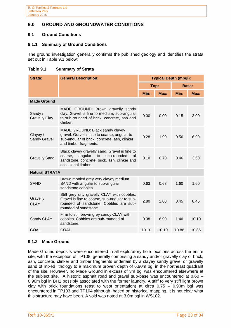
9.0 GROUND AND GROUNDWATER CONDITIONS 9.1 Ground Conditions 9.1.1 Summary of Ground Conditions The ground investigation generally confirms the published geology and identifies the strata set out in Table 9.1 below: Table 9.1 Summary of Strata
Strata: General Description: Typical Depth (mbgl):
Top: Base:
Min: Max: Min: Max:
Made Ground
Sandy / Gravelly Clay
MADE GROUND: Brown gravelly sandy clay. Gravel is fine to medium, sub-angular to sub-rounded of brick, concrete, ash and clinker.
0.00 0.00 0.15 3.00
Clayey / Sandy Gravel
MADE GROUND: Black sandy clayey gravel. Gravel is fine to coarse, angular to sub-angular of brick, concrete, ash, clinker and timber fragments.
0.28 1.90 0.56 6.90
Gravelly Sand
Black clayey gravelly sand. Gravel is fine to coarse, angular to sub-rounded of sandstone, concrete, brick, ash, clinker and occasional timber.
0.10 0.70 0.46 3.50
Natural STRATA
SAND Brown mottled grey very clayey medium SAND with angular to sub-angular sandstone cobbles.
0.63 0.63 1.60 1.60
Gravelly
CLAY
Stiff grey silty gravelly CLAY with cobbles. Gravel is fine to coarse, sub-angular to sub-rounded of sandstone. Cobbles are sub-rounded of sandstone.
2.80 2.80 8.45 8.45
Sandy CLAY Firm to stiff brown grey sandy CLAY with cobbles. Cobbles are sub-rounded of sandstone.
0.38 6.90 1.40 10.10
COAL COAL 10.10 10.10 10.86 10.86
9.1.2 Made Ground Made Ground deposits were encountered in all exploratory hole locations across the entire site, with the exception of TP108, generally comprising a sandy and/or gravelly clay of brick, ash, concrete, clinker and timber fragments underlain by a clayey sandy gravel or gravelly sand of mixed lithology to a maximum proven depth of 6.90m bgl in the northeast quadrant of the site. However, no Made Ground in excess of 3m bgl was encountered elsewhere at the subject site. A historic asphalt road and gravel sub-base was encountered at 0.60 – 0.90m bgl in BH1 possibly associated with the former laundry. A stiff to very stiff light brown clay with brick foundations (east to west orientation) at circa 0.75 – 0.90m bgl was encountered in TP103 and TP104 although, based on historical mapping, it is not clear what this structure may have been. A void was noted at 3.0m bgl in WS102.

R. G. Parkins & Partners Ltd Jefferson Park January 2015
Ref: 10-365r1 Page 24 of 34
9.1.3 Drift Deposits Natural deposits were encountered across all areas of the site, however, a number of exploratory locations in the northern sector (TP101 - TP104 and WS103 – WS104) did not penetrate to natural deposits due to deeper Made Ground (up to 6.90m bgl). A further two locations were terminated at shallow depths (<1.0m) due to obstructions. Natural deposits for the most part comprised of firm becoming very stiff at depth gravelly and/or sandy CLAY with cobbles of sub-rounded sandstone to a maximum proven depth of 10.10m bgl. 9.1.4 Solid Geology Solid geology of COAL was encountered within BH2 at 10.10m bgl. 9.1.5 Side Stability and Ease of Excavation The sides of the trial pits were predominantly observed to be stable during excavation, with the exception of TP103 and TP104 where deeper granular Made Ground deposits resulted in sidewall collapse.

R. G. Parkins & Partners Ltd Jefferson Park January 2015
Ref: 10-365r1 Page 25 of 34
Table 9.2 Standard/Cone Penetration Test Results
Boreholes Depth
(m bgl)
Material Field Description
CPT/SPT “N” Value
Corrected “N” Value
(N1)60
Terzaghi & Peck Relative Density
(Sands) Eurocode Soil strength
Consistency (BS5930)
Terzaghi & Peck Approximate Undrained Shear Strength (kN/m2)
BH1
1.2 MADE GROUND 14 13.74 N/A Medium strength Stiff 68.69
2 MADE GROUND 33 30.15 N/A Very high strength Very Stiff 150.73
3 Gravelly CLAY 50 43.48 N/A Very high strength Very Stiff 217.41
4 Gravelly CLAY 40 33.79 N/A Very high strength Very Stiff 168.97
5 Gravelly CLAY 33 27.38 N/A High strength Very Stiff 136.89
6.5 Gravelly CLAY 47 38.37 N/A Very high strength Very Stiff 191.85
8 Gravelly CLAY 41 33.19 N/A Very high strength Very Stiff 165.94
BH2
1.2 MADE GROUND 3 2.94 Very Loose N/A N/A N/A
2 MADE GROUND 6 5.48 Loose N/A N/A N/A
3 MADE GROUND 13 11.31 Medium Dense N/A N/A N/A
4 MADE GROUND 20 16.90 Medium Dense N/A N/A N/A
5 MADE GROUND 50 41.48 Dense N/A N/A N/A
6.5 CLAY 7 5.71 N/A Low strength Firm 28.57
8 CLAY 20 16.19 N/A High strength Very Stiff 80.95
9.5 CLAY 26 20.95 N/A High strength Very Stiff 104.77
10.5 COAL 120 94.67 Very Dense N/A N/A N/A
BH3
1.2 CLAY 50 49.06 N/A Very high strength Very Stiff 245.31
2 CLAY 25 22.84 N/A High strength Very Stiff 114.19
3 CLAY 23 20.00 N/A High strength Very Stiff 100.01
4 CLAY 30 25.35 N/A High strength Very Stiff 126.73
5 CLAY 50 41.48 N/A Very high strength Very Stiff 207.41
6 CLAY 50 40.99 N/A Very high strength Very Stiff 204.97
WS101 1 Sandy CLAY 10 10.08 N/A Medium strength Stiff 50.41

R. G. Parkins & Partners Ltd Jefferson Park January 2015
Ref: 10-365r1 Page 26 of 34
Boreholes Depth
(m bgl)
Material Field Description
CPT/SPT “N” Value
Corrected “N” Value
(N1)60
Terzaghi & Peck Relative Density
(Sands)
Eurocode Soil strength Consistency
(BS5930)
Terzaghi & Peck Approximate Undrained Shear Strength (kN/m2)
2 Sandy CLAY 30 27.41 N/A High strength Very Stiff 137.03
3 Gravelly CLAY 23 20.00 N/A High strength Very Stiff 100.01
4 Gravelly CLAY 40 33.79 N/A Very high strength Very Stiff 168.97
4.8 Gravelly CLAY 50 41.61 N/A Very high strength Very Stiff 208.03
WS102
1 Clayey GRAVEL 7 7.06 Loose N/A N/A N/A
2 Sandy CLAY 4 3.65 N/A Very low strength Soft 18.27
3 Sandy CLAY 1 0.87 N/A Extremely low strength Very Soft 4.35
WS103
1 MADE GROUND 8 8.07 N/A Medium strength Stiff 40.33
2 MADE GROUND 4 3.65 N/A Very low strength Soft 18.27
3 MADE GROUND 6 5.22 Loose N/A N/A N/A
4 MADE GROUND 11 9.29 Loose N/A N/A N/A
5 MADE GROUND 9 7.47 Loose N/A N/A N/A
WS104
1 MADE GROUND 6 6.05 Loose N/A N/A N/A
2 MADE GROUND 8 7.31 Loose N/A N/A N/A
3 MADE GROUND 4 3.48 Very Loose N/A N/A N/A
4 MADE GROUND 4 3.38 Very Loose N/A N/A N/A
WS105
1 MADE GROUND 2 2.02 Very Loose N/A N/A N/A
2 MADE GROUND 7 6.39 N/A Low strength Firm 31.97
3 Sandy CLAY 50 43.48 N/A Very high strength Very Stiff 217.41
WS106
1 MADE GROUND 16 16.13 N/A High strength Very Stiff 80.65
2 Sandy CLAY 19 17.36 N/A High strength Very Stiff 86.79
2.7 Sandy CLAY 49 43.13 N/A Very high strength Very Stiff 215.63
3.15 Sandy CLAY 50 43.25 N/A Very high strength Very Stiff 216.26

R. G. Parkins & Partners Ltd Jefferson Park January 2015
Ref: 10-365r1 Page 27 of 34
9.1.6 Soil Plasticity
The Atterberg Limits determinations, summarised in Table 9.3 below, show the clay to be of intermediate plasticity. Natural Moisture Content is close to the Plastic Limit.
Table 9.3 Summary of Plasticity Index Test Results
9.1.7 pH and Sulphate Chemical analyses for pH and soluble sulphate content contained in Appendix VIII (summarised below in Table 9.4), shows that the soils at the site generally meet Class DS-1, Aggressive Chemical Environment for Concrete Classification (ACEC) AC-1s in accordance with BRE Special Digest 1 (2005). However, WS101 and TP102 fall within Class DS-2, Aggressive Chemical Environment for Concrete Classification (ACEC) AC-2s in accordance with BRE Special Digest 1 (2005). Table 9.4 Summary of pH and Sulphate Data
Location Depth (m)
SO4 in 2:1 water / soil (g/l)
pH Value
TP101 1.00 0.055 8.4
TP102 0.50 0.22 6.5
TP104 1.40 0.093 7.2
TP108 0.60 0.029 7.4
TP109 0.20 0.034 7.1
TP109 0.60 0.020 7.12
TP111 0.20 0.044 7.4
TP112 0.40 0.034 8.0
TP113 0.50 0.077 7.8
9.1.8 Groundwater Conditions Groundwater was encountered at two locations as water strikes at 7.5m bgl (BH1) and 6.90m bgl (BH2). 9.2 Ground Gas Concentrations of methane (CH4), carbon dioxide (CO2) and Oxygen (O2) were measured using a calibrated infra-red gas analyser and gas flow rates were measured using an attached flow pod. Gas measurements were recorded for a minimum of sixty seconds at each location, at which point the maximum concentration of CH4 and CO2 together with the lowest concentration of O2 were recorded. The results of the ground gas monitoring are presented in Table 9.6.
Location Depth (m)
Natural Moisture Content
(%)
Plastic Limit (%)
Liquid Limit (%)
Plasticity Index (%)
Percentage passing
425μm sieve (%)
Modified Plasticity
Index
WS102 1.00 30 23 47 24 100 24

R. G. Parkins & Partners Ltd Jefferson Park January 2015
Ref: 10-365r1 Page 28 of 34
Table 9.6 Groundwater and Ground Gas Monitoring Results
Well Date
CH4
Initial
%v/v
CH4
Steady
%v/v
CH4
GSV
l/hr
CO2
Initial
%v/v
CO2
Steady
%v/v
CO2
GSV
l/hr
O2
%v/v Atmos(mb)
Atmos.
Dynamic
Flow
(l/hr)
Response
Zone
(mbgl)
Depth to
Base (mbgl)
Depth to
Water
(mbgl)
WS101
28/11/14 0 0 0 3.8 3.8 0 15.7 1002 Rising 0
0.50 –2.50
2.63 2.06
11/12/14 0 0 3.7 3.7 0 15.2 1000 Rising 0 2.62 2.00
06/01/15 0 0 0 2.7 2.7 15.2 1009 Falling 0 2.60 1.70
WS102
28/11/14 0 0 0 2.9 2.9 0 14.4 1002 Rising 0
1.00 –3.00
3.1 1.3
11/12/14 0 0 0 3.0 3.0 0 13.8 1000 Rising 0 3.1 1.2
06/01/15 0 0 0 0.8 0.8 19.7 1009 Falling 0 2.90 1.17
WS103
28/11/14 0 0 0 0.1 0 0 20.1 1002 Rising -2.46
1.00-4.00
4.05 Dry
11/12/14 0 0 0 0 0 0 20 1002 Rising -1.98 4.05 Dry
06/01/15 0 0 0 0.9 0.9 0 19.6 1009 Falling 0 4.10 4.10
WS104
28/11/14 0 0 0 1.3 1.3 0 19.3 1002 Rising 0
1.00-5.00
4.37 4.37
11/12/14 0 0 0 1 1 0 19.5 1002 Rising 0 4.36 4.36
06/01/15 0 0 0 0.8 0.8 0 19.8 1009 Falling 0 4.40 Dry

R. G. Parkins & Partners Ltd Jefferson Park January 2015
Ref: 10-365r1 Page 29 of 34
Well Date
CH4
Initial
%v/v
CH4
Steady
%v/v
CH4
GSV
l/hr
CO2
Initial
%v/v
CO2
Steady
%v/v
CO2
GSV
l/hr
O2
%v/v Atmos(mb)
Atmos.
Dynamic
Flow
(l/hr)
Response
Zone
(mbgl)
Depth to
Base (mbgl)
Depth to
Water
(mbgl)
WS105
28/11/14 0 0 0 1.7 1.7 0 18.6 1002 Rising 0
0.50-.50
2.43 2.34
11/12/14 0 0 0 1.7 1.7 0 18.6 1002 Rising 0 2.35 2.28
06/01/15 0 0 0 1.2 1.2 0 19.5 0 Falling 0 2.45 2.10
WS106
28/11/14 0 0 0 4.4 4.4 0 16.2 1002 Rising 0
0.50 –2.70
2.37 Dry
11/12/14 0 0 0 4.5 4.3 0 16 1002 Rising 0 2.35 Dry
06/01/15 0 0 0 4.7 4.7 0 14.1 1009 Falling 2.40 1.10

R. G. Parkins & Partners Ltd Jefferson Park January 2015
Ref: 10-358r1 Page 30 of 34
10.0 TIER 1 QUALITATIVE CONTAMINATED LAND RISK ASSESSMENT E3P has undertaken a Tier 1 qualitative risk assessment to determine if any potential contaminants within the underlying soils and groundwater pose an unacceptable level of risk to the identified receptors. 10.1 Human Health Risk Assessment At a Tier 1 stage the long term (chronic) human health toxicity of the soil has been assessed by comparing the on-site concentrations of organic and inorganic compounds with reference values published by the EA (Contaminated Land Exposure Assessment (CLEA) Soil Guideline Values (SGV)) and where absent, Generic Assessment Criteria (GACs) published by LQM/CIEH (2nd edition). The results of this comparison have been summarised within Table 10.1 (overleaf).

R. G. Parkins & Partners Ltd Jefferson Park January 2015
Ref: 10-365r1 Page 31 of 39
Table 10.1 Summary of Inorganic and Hydrocarbon Toxicity Assessment for a Residential End Use
Determinand Units GAC n MC Loc.of Ex (Depth m)
Pathway Assessment
Arsenic** mg/kg 37 9 43 TP101 (1.00) TP102 (0.50)
1 Further
Assessment
Cadmium mg/kg 26 9 0.7 N/A 1 No Further Action
Chromium (VI)** mg/kg 21 9 <4.0 N/A 1 No Further Action
Lead** mg/kg 210 9 750 TP101 (1.00) TP104 (1.40) TP111 (0.20)
1 Further
Assessment
Mercury mg/kg 11 9 <0.3 N/A 2 No Further Action
Nickel mg/kg 130 9 110 N/A 1 No Further Action
Selenium mg/kg 350 9 <1.0 N/A 1 No Further Action
Copper(ii) mg/kg 2330 9 820 N/A 1 No Further Action
Zinc(ii) mg/kg 3750 9 980 N/A 1 No Further Action
Cyanide - Total mg/kg 791 9 <1 N/A 1 No Further Action
Phenols - Total. mg/kg 210 9 <1 N/A 1 No Further Action
Asbestos Fibres NFD 7 All 4 Further
Assessment
Naphthalene mg/kg 1.5 9 0.23 N/A 2 No Further Action
Acenaphthylene mg/kg 170 9 0.29 N/A 3 No Further Action
Acenaphthene mg/kg 210 9 0.19 N/A 1 No Further Action
Fluorene mg/kg 160 9 0.34 N/A 1 No Further Action
Phenanthrene mg/kg 92 9 4.2 N/A 3 No Further Action
Anthracene mg/kg 2300 9 0.83 N/A 3 No Further Action
Fluoranthene mg/kg 260 9 7.3 N/A 3 No Further Action
Pyrene mg/kg 560 9 5.9 N/A 3 No Further Action
Benzo(a)Anthracene mg/kg 3.1 9 3.7 TP101 (1.00) TP113 (0.50)
3 Further
Assessment
Chrysene mg/kg 6 9 4.3 N/A 3 No Further Action
Benzo(b/k)Fluoranthene (i) mg/kg 5.6 9 3.2 N/A 3 No Further Action
Benzo(a)Pyrene** mg/kg 5.0 9 3.2 N/A 3 No Further Action
Indeno(123-cd)Pyrene mg/kg 3.2 9 0.92 N/A 3 No Further Action
Dibenzo(a,h)Anthracene mg/kg 0.76 9 0.30 N/A 3 No Further Action
Benzo(ghi)Perylene mg/kg 44 9 0.78 N/A 3 No Further Action
TPH C5-C6 mg/kg 30 9 <1.0 N/A 2 No Further Action
TPH C6-C8 mg/kg 73 9 <0.1 N/A 2 No Further Action
TPH C8-C10 mg/kg 19 9 <0.1 N/A 2 No Further Action
TPH C10-C12 mg/kg 69 9 <10 N/A 2 No Further Action
TPH C12-C16 mg/kg 140 9 14 N/A 2 No Further Action
TPH C16-C21 mg/kg 250 9 67 N/A 1 No Further Action
TPH C21-C35 mg/kg 890 9 230 N/A 1 No Further Action
Notes Main Exposure Pathways: 1 = Soil Ingestion, 2 = Vapour Inhalation (indoor), 3 = Dermal Contact & Ingestion, 4 = Dust Inhalation. Abbreviations: GAC = General Assessment Criteria, n = number of samples, MC = Maximum Concentration; Loc of Ex = Location of Exceedance; NFD = No Fibres Detected * The Tier 1 GAC for the hydrocarbon fraction is derived from the CIEH assessment for petroleum hydrocarbons Criteria Working Group (CWG) for both aliphatic and aromatic compounds. E3P has utilised the Tier 1 values for aliphatic compounds for the volatile and semi volatile fractions (C5-C12) and the Tier 1 values for aromatic compound for the non-volatile fractions (C12-C35). The comparison of a total (aliphatic/aromatic) compounds to an individual fraction is considered to be a conservative approach and satisfactory for the protection of human health. (i) Benzo (b) Fluoranthene (100mg/kg) Benzo (k) Fluoranthene (140mg/kg) (ii) GAC based on human health criteria. Ecotoxicological assessment will be made using EA guidance (EPR 8.01) on soil
spreading (Cu 135mg/kg, Zinc 200mg/kg) **pC4SL

R. G. Parkins & Partners Ltd Jefferson Park January 2015
Ref: 10-365r1 Page 32 of 39
Further Assessment Referring to Table 10.1 overleaf, the direct comparison identified that screening values for the following contaminants have been exceeded based on a residential end use:
Arsenic Lead Benzo(a)anthracene;
The laboratory analysis confirms the assessment within the initial conceptual site model that the main constituents of concern were likely to be PAHs and heavy metals. In relation to these exceedances, the following can be determined:
The main exposure pathways based on the Tier I exceedances are:
1. Dermal contact; and 2. Soil ingestion and consumption of home-grown vegetables.
The two exceedances of arsenic and benzo(a)anthracene within the shallow Made
Ground soils (<1.0m bgl) are marginally exceeding the Preliminary Category 4 Screening Level of 37mg/kg and 3.1mg/kg, respectively;
The three exceedances of lead are associated with extensive shallow Made Ground deposits; and
Asbestos was identified within 7 No. samples analysed from all areas of the site.
Risk Assessment and Mitigation The aforementioned exceedances pose a potential risk to the future end users of the site through dermal contact and soil ingestion. It is therefore considered that the risks to construction workers during the development can be mitigated through the use of appropriate PPE and good site hygiene. The marginal non-volatile exceedances are all of low solubility. For the avoidance of any doubt the soil results have been assessed using the Tier 1 GAC for a residential end use with plant uptake to take into account the exposure pathways of small children playing in external garden and soft landscaped areas of the proposed development. Given the presence of asbestos fibres within the Made Ground, a suitably detailed remediation strategy will be required to document the safe handling, management and placement of all Made Ground so as to ensure that no unacceptable degree of risk is presented to construction workers or future site occupants. Supplementary investigations are required to quantify the asbestos and fully inform the aforementioned strategy. The shallow Made Ground will not be suitable for use as Topsoil within any proposed gardens or landscaped areas due to the presence of asbestos containing material identified across the entire site and localised elevated PAH and heavy metal compounds. Therefore, a suitable cover system will be required, thereby removing any dermal contact/ingestion pathways and the risk to the identified receptors.
R. G. Parkins & Partners Ltd Jefferson Park January 2015
Ref: 10-365r1 Page 33 of 39
10.2 Controlled Waters Risk Assessment The groundwater vulnerability map shows the site drift and solid deposits to be classified as a Secondary A Aquifers which therefore represent a high sensitivity risk receptor. However, there are no potable drinking water abstractions within 1km of the site and the aquifer is afforded protection by the overlying likely low permeability Glacial Till. Therefore a Tier I risk assessment has been undertaken with concentrations of determinants compared with the relevant thresholds. These are presented in Table 10.2 overleaf.

R. G. Parkins & Partners Ltd Jefferson Park January 2015
Ref: 10-365r1 Page 34 of 39
Table 10.2 Comparison of Groundwater Analysis with Tier 1 Screening Levels
Determinand Units
EQS (V1)
Drinking Water
Threshold n MC No of Ex Loc of Ex
Assessment
Inorganics
Arsenic µg/l 50 10 1 <0.15 N/A N/A No Further Action
Cadmium µg/l 5 5 1 <0.02 N/A N/A No Further Action
Chromium (VI) µg/l 2 50 1 <5.0 N/A N/A No Further Action
Copper µg/l 5 2000 1 1.3 N/A N/A No Further Action
Cyanide µg/l - 50 1 <10 N/A N/A No Further Action
Lead µg/l 4 10 1 <0.2 N/A N/A No Further Action
Mercury µg/l 1 1 1 <0.05 N/A N/A No Further Action
Nickel µg/l 8 20 1 3.7 N/A N/A No Further Action
Selenium µg/l - 10 1 4.1 N/A N/A No Further Action
Organics
Napthalene µg/l 10 - 1 <0.01 N/A N/A No Further Action
Benzo(a)pyrene µg/l 0.05 0.01 1 <0.01 N/A N/A No Further Action benzo[b/k]fluoranthene µg/l 0.03 - 1 <0.01 N/A N/A No Further Action
benzo[g,h,i]perylene & indeno(1,2,3-cd]pyrene
µg/l 0.02 - 1
<0.01 N/A N/A No Further Action
Total Petroleum Hydrocarbons## µg/l - 10
1 <10
N/A N/A No Further Action
TPH C5-C6 µg/l - 10 1 <10 N/A N/A No Further Action
TPH C6-C8 µg/l - 10 1 <10 N/A N/A No Further Action
TPH C8-C10 µg/l - 10 1 <10 N/A N/A No Further Action
TPH C10-C12 µg/l - 10 1 <10 N/A N/A No Further Action
TPH C12-C16 µg/l - 10 1 <10 N/A N/A No Further Action
TPH C16-C21 µg/l - 10 1 <10 N/A N/A No Further Action
TPH C21-C35 µg/l - 10 1 <10 N/A N/A No Further Action
Notes # Solubility <0.01µg/l 1. Council Directive of 4 May 1976 on pollution caused by certain dangerous substances discharged into the aquatic
environment of the Community (76/464/EEC). Official Journal of the European Communities 18.5.76 L129/23 2. The Surface Waters (Dangerous Substances) (Classification) Regulations 1989. SI 2286/89 3. The Surface Waters (Dangerous Substances) (Classification) Regulations 1992. SI 337/92 4. These represent non-statutory changes made in the 1990’s which may be used by regulatory authorities. They are more
conservative than the original 1985 values. 5. EC Dangerous Substances - List 1 parameters 6. EC Dangerous Substances - List 2 parameters as listed in Dangerous Substances Regulations of 1997 and 1998, and the
DoE Circular 7/89 7. Circular from the Department of the Environment (7/89) and the Welsh Office (SI 16/89). 30 March 1989. Water and the
Environment: The implementation of European Community Directives on pollution caused by certain dangerous substances discharged into the aquatic environment
8. The Surface Waters (Dangerous Substances) (Classification) Regulations 1997. SI 2560/97 9. The Surface Waters (Dangerous Substances) (Classification) Regulations 1998. SI 389/98 10. WHO DWS for Toluene and Ethylbenzene – odour/taste/colour (Human Health Risk) 11. Specified compounds are benzo[b]fluoranthene (CAS 205-99-2), benzo[k]fluoranthene (CAS 207-08-9),
benzo[g,h,i]perylene (CAS 191-24-2) and indeno[1,2,3-c,d]pyrene (CAS 193-39-5). The parametric value applies to the sum of the concentrations of the individual compounds detected and quantified in the monitoring process.
Referring to Table 10.2, the results of this direct comparison indicates that the data does not exceed any of the Tier 1 screening criteria for controlled waters and as such no risk to the identified receptors has been identified.

R. G. Parkins & Partners Ltd Jefferson Park January 2015
Ref: 10-365r1 Page 35 of 39
10.3 Ground Gas Risk Assessment The potential impact on the development from ground gases has been assessed with reference to standards and guidelines published in CIRIA Report 665 (Assessing risks posed by hazardous ground gases to buildings, 2007). However, it is recommended that the full ground gas assessment and recommended protection measures are agreed with the local authority prior to their adoption on-site. Furthermore, all protection measures adopted should be validated by a suitably qualified engineer. The previous Phase I report and subsequent ground investigation has identified the following potential sources of ground gas:
Underlying Coal Measures; Deep Made Ground (to a maximum proven depth of 6.90m bgl); A historic refuse tip located in the north-western sector of the site; and A registered landfill located 43m west of the site boundary.
During the monitoring visit completed to date no elevated concentrations of methane and only slightly elevated concentrations of carbon dioxide (3.8%v/v ) were recorded. Monitoring undertaken to date has been completed in periods of high atmospheric pressure (>1000mb). In accordance with the methodology outlined with the CIRIA publication C665, E3P has utilised the results of the ground gas monitoring surveys to calculate a tentative Gas Screening Value (GSV). The calculated GSVs reflect the absence of any flow with CIRIA C665 stating that in instances where the maximum GSV for carbon dioxide and methane is <0.07 l/hr and typical methane and carbon dioxide are less than 1% v/v and 5% v/v respectively, then this is equivalent to Characteristic Situation 1. This suggests that no special precautions are required as there is a very low risk to future site users. However, this is an interim assessment based on preliminary ground gas readings completed during periods of high atmospheric pressure. The final classification will be supplied as an addendum to this report on completion of the remaining monitoring visits. 10.4 Conceptual Model Following the completion of the intrusive site investigation, chemical analysis and risk assessment, the conceptual site model has not identified any potentially significant contaminant sources or industrial land uses on-site or within the wider area that would prejudice the proposed residential development at the site.

R. G. Parkins & Partners Ltd Jefferson Park January 2015
Ref: 10-365r1 Page 36 of 39
11.0 GEOTECHNICAL ASSESSMENT 11.1 Summary of Ground Conditions Ground conditions identified at the site are summarised in Table 11.1 below: Table 11.1 Summary of Ground Conditions
Strata: General Description: Typical Depth (mbgl):
Top: Base:
Min: Max: Min: Max:
MADE Ground
Sandy / Gravelly Clay
MADE GROUND: Brown gravelly sandy clay. Gravel is fine to medium, sub-angular to sub-rounded of brick, concrete, ash and clinker.
0.00 0.00 0.15 3.00
Clayey / Sandy Gravel
MADE GROUND: Black sandy clayey gravel. Gravel is fine to coarse, angular to sub-angular of brick, concrete, ash, clinker and timber fragments.
0.28 1.90 0.56 6.90
Gravelly Sand
Black clayey gravelly sand. Gravel is fine to coarse, angular to sub-rounded of sandstone, concrete, brick, ash, clinker and occasional timber.
0.10 0.70 0.46 3.50
Natural STRATA
SAND Brown mottled grey very clayey medium SAND with angular to sub-angular sandstone cobbles.
0.63 0.63 1.60 1.60
Gravelly
CLAY
Stiff grey silty gravelly CLAY with cobbles. Gravel is fine to coarse, sub-angular to sub-rounded of sandstone. Cobbles are sub-rounded of sandstone.
2.80 2.80 8.45 8.45
Sandy CLAY Firm to stiff brown grey sandy CLAY with cobbles. Cobbles are sub-rounded of sandstone.
0.38 6.90 1.40 10.10
COAL COAL 10.10 10.10 10.86 10.86
11.2 Site Preparation The site should be cleared and any vegetation below areas of proposed development stripped in accordance with Series 200 of the Specification for Highway Works. This should include:
Roots present below the footprint of proposed structures and infrastructure should be grubbed out and the resulting void in-filled with suitable compacted engineered fill; and,
Redundant services should be sealed off and grubbed out and replaced with suitable compacted engineered fill; and
Buried structures and old foundations have not been encountered on site. If any are located (albeit not anticipated) these should be excavated from below the proposed development footprint with the resulting void backfilled.

R. G. Parkins & Partners Ltd Jefferson Park January 2015
Ref: 10-365r1 Page 37 of 39
11.3 Foundation Conditions and Bearing Capacity Assessment of Potential Bearing Capacities In due consideration of the identified ground conditions, in-situ and laboratory geotechnical testing, E3P has undertaken an assessment of the net safe Allowable Bearing Pressure (ABP) within the underlying natural stratum to assist in the detailed design of foundations and infrastructure and determine the target founding stratum.
Granular Soils
Description Depth (range m BGL) Relative Density Allowable Bearing Pressure (kN/m2)
Clayey/sandy GRAVEL
1.00 – 1.45 Very Loose - Loose 20 – 40
Clayey/sandy GRAVEL
2.00 – 2.45 Loose 55 – 75
Clayey/sandy GRAVEL
3.00 – 4.45 Very Loose – Medium
Dense 35 – 170
Cohesive Soils
Description Depth (range m BGL) Undrained Shear
Strength (Cu) kN/m2 Allowable Bearing Pressure (kN/m2)
Stiff to very stiff gravelly/sandy CLAY
1.00 – 1.45 40 – 245 <80 – 505
Stiff to very stiff gravelly/sandy CLAY
2.00 – 2.45 <20 – 150 <40 – 310
Soft to very stiff gravelly/sandy CLAY
3.00 – 3.45 <5 – 220 <10 – 450
Stiff to very stiff gravelly/sandy CLAY
4.00 – 4.45 125 – 170 260 – 350
Based on the assessment of the relative undrained shear strength, relative in-situ densities and corresponding safe net Allowable Bearing Potential, a suitable target founding stratum has not been wholly determined given the depth and variability of Made Ground.
Alternatively, structural loading could be transferred to the deep natural drift deposits though a driven pile foundation to be designed by a specialist contractor and the Structural Engineer. 11.4 Ground Floor Slabs Due to the presence of substantial thickness’ of Made Ground across the site is considered that ground bearing floor slabs, whilst viable, will require detailed design to accommodate variability of the formation and account for differential settlement. Where suspended floor slabs are employed ventilation of the under floor void will be required to address condensation issues. This would also assist in the mitigation of potential gas ingress issues.
The Made Ground is not considered suitable bearing stratum to support a shallow foundation due to the unquantified potential for long term differential and total settlement.
It is considered the proposed foundations could be supported using vibro replacement granular stone columns to facilitate the use of shallow (re-enforced) strip foundations within the treated Made Ground.
R. G. Parkins & Partners Ltd Jefferson Park January 2015
Ref: 10-365r1 Page 38 of 39
11.5 Pavement Construction An assessment of the likely California Bearing Ratio (CBR) has not been undertaken as part of this report due the extensive variable Made Ground. It is, however, considered that a CBR of less than 3% may be required to account for variability of the Made Ground. Therefore a geotextile re-enforcement layer and additional capping to the sub-base may be required to ensure the most economic road construction. Following excavation the sub formation should be proof rolled and any soft material inspected and removed. 11.6 Drainage The presence of substantial depths of Made Ground across areas of the site may result in settlement. It is therefore recommended that drain runs are designed using steeper gradients and flexible joints to allow for some differential settlement. Furthermore, the site is predominantly underlain by circa 3-4m of likely low permeability gravelly and/or sandy CLAY and as such the use of soak-away drainage will be limited. If soak-away drainage is to be considered, full BRE365 Testing must be completed to inform the detailed design. 11.7 Concrete Durability Based upon the results of the chemical analyses summarised in it is considered that subsurface concrete can be designed in accordance with Design Sulphate Class DS-1, Aggressive Chemical Environment for Concrete Classification (ACEC) AC-1s in accordance with the recommendations provided in BRE Special Digest 1 (2005). 11.8 Excavations
Site observations indicated that excavations should be feasible in the near surface with normal plant, however obstructions were identified in the near surface including possible relic foundations. It is anticipated that any obstructions will be grubbed out during the reduced level dig for the sub structure works. Due to the depth and variability of the Made Ground and likelihood of trench collapse it is considered that all excavations are supported or battered back in accordance with guidance contained in CIRIA R97. 11.9 Minerals The site has been historically mined/worked although mining has ceased. There are no longer expected to be minerals of economic value underlying the site at shallow depth and mining is considered to be very unlikely. The site is considered to be minerally stable. 11.10 Further Works
Based on the findings of the site investigation, the following additional works are recommended to be completed in due course:
Further investigation utilising Rotary boreholes to determine the presence of shallow mine workings and/or stabilisation by drilling and grouting beneath proposed buildings throughout the site;
Plot Specific Foundation Schedule;

R. G. Parkins & Partners Ltd Jefferson Park January 2015
Ref: 10-365r1 Page 39 of 39
Materials Management Plan; and
Geo-technical Earthworks Strategy (Infrastructure). 11.10 Construction Activity and Inspection The following activities and inspections should be incorporated in to the site works:
Due to the variability of the soils at the site it is recommended that sufficient allowance is made for the inspection of formation and sub formations to foundations and pavement construction:
Excavations where access is required should be subject to a risk assessment from a competent person and where appropriate mitigation measures such as benching back the sides or use of support systems in accordance with CIRIA R97 utilised;
It is considered that de-watering may be required, especially following periods of heavy rainfall. Removal of surface water and water within trenches should be possible with conventional sump pumping. Discharge of any water should be agreed with the relevant regulatory body and be undertaken under a trade effluent discharge, where required. Measures to remove silt and suspended solids may be required and consideration should be given to provision of space for settling tanks or an attenuation pond;
Where access to confined spaces is required appropriate mitigation measures should be addressed within the Construction Stage Health and Safety Plan. Particular account should be taken of the gas results; and,
The presence of potential contamination and mitigation measures should be addressed as part of the Construction Stage Health and Safety Plan and should include measures to design out the risks, reduce their impact and finally the use of Personnel Protective Equipment (PPE).
R. G. Parkins & Partners Ltd Jefferson Park January 2015
Ref: 10-365r1 Page 40 of 39
12.0 CONCLUSIONS & RECOMMENDATIONS
Geotechnical Assessment
Compressible ground and subsidence hazards have been identified associated with historical shallow mine workings in the locality for which there are no records of stabilisation. As such special precautions with regard to foundations may be required. A number of relic foundations and obstructions were encountered during the intrusive Ground Investigation.
The Made Ground is not considered suitable bearing stratum to support a shallow foundation due to the unquantified potential for long term differential and total settlement.
It is considered the proposed foundations could be supported using vibro replacement granular stone columns to facilitate the use of shallow (re-enforced) strip foundations within the treated Made Ground.
Alternatively, structural loading could be transferred to the deep natural drift deposits though a driven pile foundation to be designed by a specialist contractor and the Structural Engineer. It is considered the predominantly cohesive soils matrix underlying the Made Ground is unlikely to provide a high degree of soakage potential for drainage systems.
The Made Ground and shallow clay soils can be re-engineered to facilitate the construction of a suitable sub-grade to provide a CBR design % in excess of 5 for new highways and infrastructure.
Based upon the results of the chemical analyses the concrete classification will be DS-1 AC-1s.
Revised Conceptual Site Model
Human Health The Tier 1 human health risk assessment identified elevated concentrations of benzo(a)anthracene, lead and arsenic which exceed the GAC values within the near surface soils. In addition, asbestos was encountered in a number of Made Ground samples from across the proposed development. Further investigation and detailed quantitative risk assessment to determine the concentrations of asbestos within the impacted made ground and inform the production of a detailed Remediation Strategy that will ensure the mitigation of risk to all identified receptors; E3P considers the shallow Made Ground will not be suitable for use as Topsoil within any proposed gardens or landscaped areas due to the presence of asbestos containing material identified across the entire site and localised elevated PAH and heavy metal compounds. Therefore E3P recommends a suitable cover system will need to be provided, thereby removing any dermal contact/ingestion pathways and the risk to the identified receptors. Controlled Water The Tier 1 controlled water assessment has not identified any potential source, pathway or viable receptor, therefore given the absence of any potentially complete pollutant linkage the site is determined to pose no unacceptable level of risk to controlled waters and the wider environ. Ground Gas Monitoring to date has identified no elevated concentrations of potentially hazardous ground gasses and as such the initial assessment suggests that no specialist mitigation measures are required. However monitoring is ongoing and the final assessment will be subject to the collation of a full dataset.
END OF REPORT

R. G. Parkins & Partners Ltd Jefferson Park January 2015
APPENDIX I LIMITATIONS
R. G. Parkins & Partners Ltd Jefferson Park January 2015
1. This report and its findings should be considered in relation to the terms of reference and objectives agreed between E3P Ltd and the Client as indicated in Section 1.2.
2. For the work, reliance has been placed on publicly available data obtained from the sources identified. The
information is not necessarily exhaustive and further information relevant to the site may be available from other sources. When using the information it has been assumed it is correct. No attempt has been made to verify the information.
3. This report has been produced in accordance with current UK policy and legislative requirements for land
and groundwater contamination which are enforced by the local authority and the Environment Agency. Liabilities associated with land contamination are complex and requires advice from legal professionals.
4. During the site walkover reasonable effort has been made to obtain an overview of the site conditions.
However, during the site walkover no attempt has been made to enter areas of the site that are unsafe or present a risk to health and safety, are locked, barricaded, overgrown, or the location of the area has not be made known or accessible.
5. Access considerations, the presence of services and the activities being carried out on the site limited the
locations where sampling locations could be installed and the techniques that could be used. 6. In addition to the above E3P Ltd note that when investigating, or developing, potentially contaminated land it
is important to recognise that sub-surface conditions may vary spatially and also with time. The absence of certain ground, ground gas, and contamination of groundwater conditions at the positions tested is not a guarantee that such conditions do not exist anywhere across the site. Due to the presence of existing buildings and structures access could not be obtained to all areas. Additional contamination may be identified following the removal of the buildings or hard standing.
7. Site sensitivity assessments have been made based on available information at the time of writing and are
ultimately for the decision of the regulatory authorities. 8. Where mention has been made to the identification of Japanese Knotweed and other invasive plant species
and asbestos or asbestos-containing materials this is for indicative purposes only and do not constitute or replace full and proper surveys.
9. The executive summary, conclusions and recommendations sections of the report provide an overview and
guidance only and should not be specifically relied upon without considering the context of the report in full. 10. This report presents an interpretation of the geotechnical information established by excavation, observation
and testing. Whilst every effort is made in interpretative reporting to assess the soil conditions over the Site it should be noted that natural strata vary from point to point and that man made deposits are subject to an even greater diversity. Groundwater conditions are dependent on seasonal and other factors. Consequently there may be conditions present not revealed by this investigation.
11. E3P cannot be held responsible for any use of the report or its contents for any purpose other than that for
which it was prepared. The copyright in this report and other plans and documents prepared by E3P is owned by them and no such plans or documents may be reproduced, published or adapted without written consent. Complete copies of this may, however, be made and distributed by the client as is expected in dealing with matters related to its commission. Should the client pass copies of the report to other parties for information, the whole report should be copied, but no professional liability or warranties shall be extended to other parties by E3P in this connection without their explicit written agreement there to by E3P.
12. Rather, this investigation has been undertaken to provide a preliminary characterisation of the existing sub-
surface geotechnical characteristics and make up and the findings of this study are our best interpretation of the data collected, within the scope of work and agreed budget. New information, revised practices or changes in legislation may necessitate the re-interpretation of the report, in whole or in part.
13. This investigation has been undertaken to reasonably characterise existing sub-surface conditions and the
findings of this study are our best interpretation of the data collected, within the scope of work and agreed budget. New information, revised practices or changes in legislation may necessitate the re-interpretation of the report, in whole or in part.

R. G. Parkins & Partners Ltd Jefferson Park January 2015
APPENDIX II GLOSSARY

R. G. Parkins & Partners Ltd Jefferson Park January 2015
TERMS
AST Above Ground Storage Tank
BGS British Geological Survey
BSI British Standards Institute
BTEX Benzene, Toluene, Ethylbenzene, Xylenes
CIEH Chartered Institute of Environmental Health
CIRIA Construction Industry Research Association
CLEA Contaminated Land Exposure Assessment
CSM Conceptual Site Model
DNAPL Dense Non-Aqueous Phase Liquid (chlorinated solvents, PCB)
DWS Drinking Water Standard
EA Environment Agency
EQS Environmental Quality Standard
GAC General Assessment Criteria
GL Ground Level
GSV Gas Screening Value
HCV Health Criteria Value
ICSM Initial Conceptual Site Model
LNAPL Light Non-Aqueous Phase Liquid (petrol, diesel, kerosene)
ND Not Detected
LMRL Lower Method Reporting Limit
NR Not Recorded
PAH Poly Aromatic Hydrocarbon
PCB Poly-Chlorinated Biphenyl
PID Photo Ionisation Detector
QA Quality Assurance
SGV Soil Guideline Value
SPH Separate Phase Hydrocarbon
Sp.TPH (CWG) Total Petroleum Hydrocarbon (Criteria Working Group)
SPT Standard Penetration Test
SVOC Semi Volatile Organic Compound
UST Underground Storage Tank
VCCs Vibro Concrete Columns
VOC Volatile Organic Compound
WTE Water Table Elevation
UNITS
m Metres
km Kilometres
% Percent
%v/v Percent volume in air
mb Milli Bars (atmospheric pressure)
l/hr Litres per hour
µg/l Micrograms per Litre (parts per billion)
ppb Parts Per Billion
mg/kg Milligrams per kilogram (parts per million)
ppm Parts Per Million
mg/m3 Milligram per metre cubed

R. G. Parkins & Partners Ltd Jefferson Park January 2015
m bgl Metres Below Ground Level
m bcl Metre Below Cover Level
mAOD Metres Above Ordnance Datum (sea level)
kN/m2 Kilo Newtons per metre squared
µm Micro metre

R. G. Parkins & Partners Ltd Jefferson Park January 2015
APPENDIX III DRAWINGS

R. G. Parkins & Partners Ltd Jefferson Park January 2015
Site Location Map
Site

The client must not amend any drawing, design or other intellectual property produced by E3P Ltd without permission in writing
from E3P Ltd in advance of any amendments being made. In the event that such written permission is not obtained in advance of
the amendments being made, E3P Ltd shall not be liable for any damage and/or losses occurring as a result of the amended
drawing, design or intellectual property.
Environmental Energy Engineering
Partnerships Ltd
City Heliport & Business Centre
Eccles, Manchester, M30 7RU
Tel: 0161 707 9612
E-mail: [email protected]
Website: www.e3p.co.uk
Job Title: Drawing Title:
Jefferson Park
Client: Job No:
R.G.Parkins and
partners Ltd
Current Site Layout
Drawing No: Scale:
Date:
10365
002
NTS @ A4
08-12-2014
JM ST
Phase Date Issue Drawn Authorised
Key:
Revision
Notes:
Existing Residential Buildings.
Grass (Undeveloped)

Type
1A
Type
1B
Type
1B
Type
1B
Type
1C
Type
3A
Type
3B
Type
3B
Type
3C
Type
2A
Type
2B
Type
2B
Type
2C
Type
4A
Type
4B
3m @ 1in12
= 250mm
1.5m @ 1in12
= 125mm
3m @ 1in12
= 250mm
3m @ 1in12
= 250mm
1.5m @ 1in12
= 125mm
28.8m
4m @ 1in12
= 333mm
1.5m
retaining
wall
1.7m to 5m
retaining
wall
1m to 1.5m
retaining
wall
Bin Drop Off
Bin Drop Off
Bin Drop Off
The client must not amend any drawing, design or other intellectual property produced by E3P Ltd without permission in writing
from E3P Ltd in advance of any amendments being made. In the event that such written permission is not obtained in advance of
the amendments being made, E3P Ltd shall not be liable for any damage and/or losses occurring as a result of the amended
drawing, design or intellectual property.
Environmental Energy Engineering
Partnerships Ltd
City Heliport & Business Centre
Eccles, Manchester, M30 7RU
Tel: 0161 707 9612
E-mail: [email protected]
Website: www.e3p.co.uk
Job Title: Drawing Title:
Jefferson Park
Client: Job No:
R.G.Parkins and
partners Ltd
Proposed Development
Drawing No: Scale:
Date:
10365
003
NTS @ A4
08-12-2014
JN ST
Phase Date Issue Drawn Authorised
Key:
Revision
Notes:

Excavation/ Embankment
Pre 1897
Laundry Works
Pre 1925 - Pre 2014
Track
Pre 1925 - Pre 2014
Laundry Extension
Pre 1962
Unspecified Building
Pre 1962
Extension to Laundry Works
Pre 1962
Refuse Tip
Pre 1962
The client must not amend any drawing, design or other intellectual property produced by E3P Ltd without permission in writing
from E3P Ltd in advance of any amendments being made. In the event that such written permission is not obtained in advance of
the amendments being made, E3P Ltd shall not be liable for any damage and/or losses occurring as a result of the amended
drawing, design or intellectual property.
Environmental Energy Engineering
Partnerships Ltd
City Heliport & Business Centre
Eccles, Manchester, M30 7RU
Tel: 0161 707 9612
E-mail: [email protected]
Website: www.e3p.co.uk
Job Title: Drawing Title:
Jefferson Park
Client: Job No:
Historical Features
Drawing No: Scale:
Date:
10365
004
NTS @ A4
08-12-2014
JN
JM
AS
AS
Phase Date Issue Drawn Authorised
Key:
Revision
Notes:
R.G.Parkins and
partners Ltd
Areas of Excavation / Possible In-filled Ground
P1
P1
12-01-2015
08-12-2014
R1
R0
Revision
Original

The client must not amend any drawing, design or other intellectual property produced by E3P Ltd without permission in writing
from E3P Ltd in advance of any amendments being made. In the event that such written permission is not obtained in advance of
the amendments being made, E3P Ltd shall not be liable for any damage and/or losses occurring as a result of the amended
drawing, design or intellectual property.
Environmental Energy Engineering
Partnerships Ltd
City Heliport & Business Centre
Eccles, Manchester, M30 7RU
Tel: 0161 707 9612
E-mail: [email protected]
Website: www.e3p.co.uk
Job Title: Drawing Title:
Jefferson Park
Client: Job No:
Exploratory Hole Location
Plan
Drawing No: Scale:
Date:
10365
005
NTS @ A4
08-12-2014
JM ST
Phase Date Issue Drawn Authorised
Approximate Window Sample Probehole Location
Approximate Trial Pit Location
Approximate Cable Percussive Borehole Location
Approximate California Bearing Ratio Test Location
Approximate Dynamic Cone Penetrometer Test Location
Approximate Hand Dug Pit Location
Approximate Rotary Borehole Location
Approximate Window Sample Probehole Location
Key:
Revision
Notes:
R.G.Parkins and
partners Ltd

The client must not amend any drawing, design or other intellectual property produced by E3P Ltd without permission in writing
from E3P Ltd in advance of any amendments being made. In the event that such written permission is not obtained in advance of
the amendments being made, E3P Ltd shall not be liable for any damage and/or losses occurring as a result of the amended
drawing, design or intellectual property.
Environmental Energy Engineering
Partnerships Ltd
City Heliport & Business Centre
Eccles, Manchester, M30 7RU
Tel: 0161 707 9612
E-mail: [email protected]
Website: www.e3p.co.uk
Job Title: Drawing Title:
Jefferson Park
Client: Job No:
Depth of Made Ground
Drawing No: Scale:
Date:
10365
006NTS @ A4
08-12-2014
JN AS
Phase Date Issue Drawn Authorised
Approximate Window Sample Probehole Location
Approximate Trial Pit Location
Approximate Cable Percussive Borehole Location
Key:
Revision
Notes:
R.G.Parkins and
partners Ltd
Depth of Made Ground Between 0.00 - 0.99m
Depth of Made Ground Between 1.00 - 1.99m
Depth of Made Ground Between 2.00+
No Made Ground encountered.
P1 13/01/2015 DraftR0

The client must not amend any drawing, design or other intellectual property produced by E3P Ltd without permission in writing
from E3P Ltd in advance of any amendments being made. In the event that such written permission is not obtained in advance of
the amendments being made, E3P Ltd shall not be liable for any damage and/or losses occurring as a result of the amended
drawing, design or intellectual property.
Environmental Energy Engineering
Partnerships Ltd
City Heliport & Business Centre
Eccles, Manchester, M30 7RU
Tel: 0161 707 9612
E-mail: [email protected]
Website: www.e3p.co.uk
Job Title: Drawing Title:
Client: Job No:
Mine abandonment Plan
Drawing No: Scale:
Date:
10365
007
NTS @ A4
09-01-2015
JN AS
Phase Date Issue Drawn Authorised
Whitehaven Main Coal - Partial or Full Extraction.
Key:
Revision
Notes:
P1 09/01/2015 DraftR0
Jefferson Park
R.G.Parkins and
partners Ltd
Proposed Development Site Boundary.
Howgill Head Mine (December 1920)
Plan of Underground Fireclay Workings.

Low Road
Drift
Two Historic Mine
Shafts Located Off
Site.
Made Ground
West East
Likely Historic drift strata
cross section
Yard Coal
Bannock Coal
Main Coal
Representative Cross Section - Looking North
The client must not amend any drawing, design or other intellectual property produced by E3P Ltd without permission in writing
from E3P Ltd in advance of any amendments being made. In the event that such written permission is not obtained in advance of
the amendments being made, E3P Ltd shall not be liable for any damage and/or losses occurring as a result of the amended
drawing, design or intellectual property.
Environmental Energy Engineering
Partnerships Ltd
City Heliport & Business Centre
Eccles, Manchester, M30 7RU
Tel: 0161 707 9612
E-mail: [email protected]
Website: www.e3p.co.uk
Job Title: Drawing Title:
Jefferson Park
Client: Job No:
R.G.Parkins &
Partners Ltd
Geological Mapping
Drawing No: Scale:
Date:
10365
008NTS @ A4
09-01-2015
JN ST
Phase Date Issue Drawn AuthorisedRevision
Notes:
R0 09/01/2015 Draft
Original

R. G. Parkins & Partners Ltd Jefferson Park January 2015
APPENDIX IV PHOTOGRAPH
PLATE 1 – A VIEW OF THE SITE LOOKING EAST TOWARDS LOW ROAD.
PLATE 2 – A VIEW OF THE SITE LOOKING NORTHWEST TOWARDS EXISTING RESIDENTIAL DEVELOPMENT.

R. G. Parkins & Partners Ltd Jefferson Park January 2015
APPENDIX V HISTORICAL MAPS

R. G. Parkins & Partners Ltd Jefferson Park January 2015
Historical Map Dated: 1879
Original Scale: 1:2,500
North

R. G. Parkins & Partners Ltd Jefferson Park January 2015
Historical Map Dated: 1899
Original Scale: 1:2,500
North

R. G. Parkins & Partners Ltd Jefferson Park January 2015
Historical Map Dated: 1925
Original Scale: 1:2,500
North

R. G. Parkins & Partners Ltd Jefferson Park January 2015
Historical Map Dated: 1962
Original Scale: 1:2,500
North

R. G. Parkins & Partners Ltd Jefferson Park January 2015
Historical Map Dated: 1994
Original Scale: 1:2,500
North

R. G. Parkins & Partners Ltd Jefferson Park January 2015
APPENDIX VI E3P EXPLORATORY LOGS

Borehole LogBorehole No.
BH1Sheet 1 of 1
Project Name: Jefferson ParkProject No.
10365Co-ords: -
Hole Type
CP
Location: Whitehaven Level:Scale
1:50
Client: R. G. Parkins Dates: 10/11/2014 -Logged By
J O'Keeffe
Remarks
WellWater Strikes
Samples and In Situ Testing
Depth (m) Type Results
Depth(m)
0.60
0.901.00
2.80
8.45
Level(m)
Legend Stratum Description
MADE GROUND: Brown gravelly sandy clay. Gravel is fine to medium, sub-angular to sub-rounded of brick and concrete.
MADE GROUND: Asphalt (historic road) and underlying gravel sub-base. MADE GROUND: Black Ash Fill.Stiff brown gravelly sandy CLAY. Gravel is fine to medium, sub-rounded of sandstone and mudstone with occasional coal.
Very stiff grey silty gravelly CLAY with cobbles. Gravel is fine to coarse sub-angular to sub-rounded of sandstone. Cobbles are sub-rounded of sandstone.
End of borehole at 8.45 m
1
2
3
4
5
6
7
8
9
10
1.20 N=14 (2,3/3,3,4,4)
2.00 N=33 (4,6/7,8,8,10)
3.00 50 (6,10/50 for 225mm)
4.00 N=40 (7,8/9,9,10,12)
5.00 N=33 (14,6/10,6,6,11)
6.50 N=47 (3,4/15,18,7,7)
8.00 N=41 (10,11/19,5,8,9)

Borehole LogBorehole No.
BH2Sheet 1 of 2
Project Name: Jefferson ParkProject No.
10365Co-ords: -
Hole Type
CP
Location: Whitehaven Level:Scale
1:50
Client: R. G. Parkins Dates: 10/11/2014 -Logged By
J O'Keeffe
Remarks
WellWater Strikes
Samples and In Situ Testing
Depth (m) Type Results
Depth(m)
1.30
6.90
8.20
Level(m)
Legend Stratum Description
MADE GROUND: Brown gravelly sandy clay. Gravel is fine to medium angular to sub-rounded of sandstone, brick, ash and clinker.
MADE GROUND: Black sandy clayey gravel. Gravel is fine to coarse, angular to sub-angular of brick, concrete, ash, clinker and timber fragments.
Firm brown grey CLAY.
Very stiff brown CLAY with cobbles. Cobbles are sub-rounded of sandstone.
Continued on next sheet
1
2
3
4
5
6
7
8
9
10
1.20 N=3 (1,2/1,0,1,1)
2.00 N=6 (1,2/1,1,2,2)
3.00 N=13 (1,2/6,2,2,3)
4.00 N=20 (2,3/4,5,5,6)
5.00 50 (10,14/50 for 100mm)
6.50 N=7 (3,2/1,2,2,2)
8.00 N=20 (3,3/4,5,4,7)
9.50 N=26 (2,3/4,5,7,10)

Borehole LogBorehole No.
BH2Sheet 2 of 2
Project Name: Jefferson ParkProject No.
10365Co-ords: -
Hole Type
CP
Location: Whitehaven Level:Scale
1:50
Client: R. G. Parkins Dates: 10/11/2014 -Logged By
J O'Keeffe
Remarks
WellWater Strikes
Samples and In Situ Testing
Depth (m) Type Results
Depth(m)
10.10
10.86
Level(m)
Legend Stratum Description
Coal
End of borehole at 10.50 m
11
12
13
14
15
16
17
18
19
20
10.50 50 (25 for 105mm/50 for 115mm)

Borehole LogBorehole No.
BH3Sheet 1 of 1
Project Name: Jefferson ParkProject No.
10365Co-ords: -
Hole Type
CP
Location: Whitehaven Level:Scale
1:50
Client: R. G. Parkins Dates: 11/11/2014 -Logged By
J O'Keeffe
Remarks
WellWater Strikes
Samples and In Situ Testing
Depth (m) Type Results
Depth(m)
0.90
2.50
3.50
6.00
Level(m)
Legend Stratum Description
MADE GROUND: Dark brown firm to stiff gravelly sandy clay. Gravel is fine to medium, angular to sub-rounded of sandstone, concrete and brick.
No recovery (Large obstruction).
Very stiff brown CLAY with cobbles. Cobbles are sub-rounded of sandstone.
Very stiff grey brown CLAY with cobbles. Cobbles are sub-rounded of sandstone.
End of borehole at 6.00 m
1
2
3
4
5
6
7
8
9
10
1.00 50 (25 for 70mm/50 for 75mm)
2.00 N=25 (12,6/6,6,6,7)
3.00 N=23 (3,4/5,5,6,7)
4.00 N=30 (4,6/7,6,8,9)
5.00 N=50 (7,10/12,14,16,8)
6.00 0 (75 for 100mm/0 for 0mm)

Trial Pit LogTrialpit No
TP101Sheet 1 of 1
Project Name:
Jefferson ParkProject No.
10365
Co-ords:
Level:
- Date
10/11/2014
Location:
Client:
Whitehaven
R. G. Parkins
Dimensions (m):
Depth3.50
0.6
1.7 Scale1:25
LoggedJ O'Keeffe
Remarks:
Stability: Stable
Wat
erS
trik
e Samples and In Situ Testing
Depth Type Results
Depth(m)
0.10
3.50
Level(m)
Legend Stratum Description
MADE GROUND: Brown gravelly sandy clay. Gravel is fine to medium, angular to sub-rounded of sandstone and brick. MADE GROUND: Black clayey gravelly sand. Gravel is fine to coarse, angular to sub-rounded of sandstone, concrete, brick and occasional timber. With occasional firm to stiff grey clay lenses.
End of pit at 3.50 m
1
2
3
4
5
1.00 ES
2.50 ES

Trial Pit LogTrialpit No
TP102Sheet 1 of 1
Project Name:
Jefferson ParkProject No.
10365
Co-ords:
Level:
- Date
10/11/2014
Location:
Client:
Whitehaven
R. G. Parkins
Dimensions (m):
Depth2.70
0.6
1.7 Scale1:25
LoggedJ O'Keeffe
Remarks:
Stability: Stable
Wat
erS
trik
e Samples and In Situ Testing
Depth Type Results
Depth(m)
2.70
Level(m)
Legend Stratum Description
MADE GROUND: Brown very sandy gravelly clay with cobbles. Gravel is fine to coarse, anuglar to sub-rounded of concrete, brick, clinker, sandstone, metal drainpipe, pallet straps and occasional pots and rootlets. Cobbles are angular to sub-rounded of brick and sandstone. With a 100mm lense of ash, brick and clinker at circa 1.2m bgl.
End of pit at 2.70 m
1
2
3
4
5
0.50 ES
2.00 ES

Trial Pit LogTrialpit No
TP103Sheet 1 of 1
Project Name:
Jefferson ParkProject No.
10365
Co-ords:
Level:
- Date
10/11/2014
Location:
Client:
Whitehaven
R. G. Parkins
Dimensions (m):
Depth2.90
0.6
1.7 Scale1:25
LoggedJ O'Keeffe
Remarks:
Stability: Unstable
Wat
erS
trik
e Samples and In Situ Testing
Depth Type Results
Depth(m)
0.28
0.56
0.87
2.90
Level(m)
Legend Stratum Description
MADE GROUND: Brown gravelly sandy clay. Gravel is fine to medium, angular to sub-rounded of sandstone and brick.
MADE GROUND: Black very sandy gravel. Gravel is fine to coarse, angular to sub-angular of clinker and ash.
MADE GROUND: Very stiff light brown clay. With brick foundation at circa 0.75-0.90m bgl (east to west).
MADE GROUND: Black very sandy gravel. Gravel is fine to coarse, angular to sub-angular of clinker and ash.
End of pit at 2.90 m
1
2
3
4
5
0.10 ES
0.40 ES
HVP=120

Trial Pit LogTrialpit No
TP104Sheet 1 of 1
Project Name:
Jefferson ParkProject No.
10365
Co-ords:
Level:
- Date
10/11/2014
Location:
Client:
Whitehaven
R. G. Parkins
Dimensions (m):
Depth3.20
0.6
1.7 Scale1:25
LoggedJ O'Keeffe
Remarks:
Stability: Unstable
Wat
erS
trik
e Samples and In Situ Testing
Depth Type Results
Depth(m)
0.38
0.70
3.20
Level(m)
Legend Stratum Description
MADE GROUND: Brown gravelly sandy clay. Gravel is fine to medium, angular to sub-rounded of sandstone and brick.
MADE GROUND: Stiff light brown clay. With brick foundation at circa 0.75-0.90m bgl (east to west).
MADE GROUND: Dark brown clayey very gravelly sand with cobbles. Gravel is fine to medium, angular to sub-angular of ash, clinker, concrete sandstone and brick. Cobbles are angular to sub-angular of mudstone and old broken pipe.
End of pit at 3.20 m
1
2
3
4
5
0.20 ES
HVP=64
1.40 ES

Trial Pit LogTrialpit No
TP105Sheet 1 of 1
Project Name:
Jefferson ParkProject No.
10365
Co-ords:
Level:
- Date
10/11/2014
Location:
Client:
Whitehaven
R. G. Parkins
Dimensions (m):
Depth3.15
0.6
1.7 Scale1:25
LoggedJ O'Keeffe
Remarks:
Stability: Stable
Wat
erS
trik
e Samples and In Situ Testing
Depth Type Results
Depth(m)
0.12
1.00
1.90
2.10
3.15
Level(m)
Legend Stratum Description
MADE GROUND: Stiff to firm brown gravelly sandy clay. Gravel is fine to medium, sub-angular to sub-rounded of brick sandstone and concrete.MADE GROUND: Dark brown clayey very gravelly sand with cobbles. Gravel is fine to medium, angular to sub-angular of ash, clinker, concrete sandstone and brick. Cobbles are angular to sub-angular of mudstone.
MADE GROUND: Red black clayey very gravelly sand with cobbles. Gravel is fine to medium, angular to sub-angular of ash, clinker, concrete sandstone and brick. Cobbles are angular to sub-angular of mudstone.
MADE GROUND: Black clayey very sandy gravel. Gravel is fine to medium, angular to sub-angular of ash and clinker.Firm to Stiff brown gravelly very sandy CLAY. Gravel is fine to medium, sub-angular to sub-rounded of sandstone.
End of pit at 3.15 m
1
2
3
4
5
HVP=50
2.50 ES

Trial Pit LogTrialpit No
TP106Sheet 1 of 1
Project Name:
Jefferson ParkProject No.
10365
Co-ords:
Level:
- Date
10/11/2014
Location:
Client:
Whitehaven
R. G. Parkins
Dimensions (m):
Depth1.40
0.6
1.7 Scale1:25
LoggedJ O'Keeffe
Remarks:
Stability: Stable
Wat
erS
trik
e Samples and In Situ Testing
Depth Type Results
Depth(m)
0.38
1.40
Level(m)
Legend Stratum Description
MADE GROUND: Brown slightly gravelly sandy clay. Gravel is fine to coarse, angular to sub-rounded of brick, concrete and sandstone.
Very stiff brown mottled grey sandy CLAY.
End of pit at 1.40 m
1
2
3
4
5
0.10 ES
HVP=119
1.10 ES

Trial Pit LogTrialpit No
TP107Sheet 1 of 1
Project Name:
Jefferson ParkProject No.
10365
Co-ords:
Level:
- Date
10/11/2014
Location:
Client:
Whitehaven
R. G. Parkins
Dimensions (m):
Depth3.20
0.6
1.7 Scale1:25
LoggedJ O'Keeffe
Remarks:
Stability: Stable
Wat
erS
trik
e Samples and In Situ Testing
Depth Type Results
Depth(m)
0.15
2.80
3.20
Level(m)
Legend Stratum Description
MADE GROUND: Brown gravelly sandy clay. Gravel is fine to medium, angular to sub-rounded of sandstone and brick. MADE GROUND: Dark brown clayey very gravelly sand with cobbles. Gravel is fine to medium, angular to sub-angular of ash, clinker, concrete sandstone and brick. Cobbles are angular to sub-angular of mudstone and broken pipe.
Firm to stiff brown gravelly very sandy CLAY. Gravel is fine to medium, sub-angular to sub-rounded of sandstone.
End of pit at 3.20 m
1
2
3
4
5
HVP=52

Trial Pit LogTrialpit No
TP108Sheet 1 of 1
Project Name:
Jefferson ParkProject No.
10365
Co-ords:
Level:
- Date
10/11/2014
Location:
Client:
Whitehaven
R. G. Parkins
Dimensions (m):
Depth1.60
0.6
1.7 Scale1:25
LoggedJ O'Keeffe
Remarks:
Stability: Stable
Wat
erS
trik
e Samples and In Situ Testing
Depth Type Results
Depth(m)
0.63
1.60
Level(m)
Legend Stratum Description
Very stiff light brown mottled grey sandy CLAY with fine to medium coal.
Brown mottled grey very clayey medium SAND with angular to sub-angular sandstone and cobbles.
End of pit at 1.60 m
1
2
3
4
5
HVP=100 0.60 ES

Trial Pit LogTrialpit No
TP109Sheet 1 of 1
Project Name:
Jefferson ParkProject No.
10365
Co-ords:
Level:
- Date
10/11/2014
Location:
Client:
Whitehaven
R. G. Parkins
Dimensions (m):
Depth1.70
0.6
1.7 Scale1:25
LoggedJ O'Keeffe
Remarks:
Stability: Stable
Wat
erS
trik
e Samples and In Situ Testing
Depth Type Results
Depth(m)
0.15
0.46
1.70
Level(m)
Legend Stratum Description
MADE GROUND: Brown gravelly sandy clay. Gravel is fine to medium, angular to sub-rounded of sandstone and brick. MADE GROUND: Dark brown slightly clayey gravelly sand. Gravel is fine to medium, angular to sub-rounded of brick, coal and sandstone.Very stiff brown gravelly very sandy CLAY. Gravel is fine to medium, sub-angular to sub-rounded of sandstone and coal.
End of pit at 1.70 m
1
2
3
4
5
0.20 ES
HVP=120 0.70 ES
HVP=105

Trial Pit LogTrialpit No
TP110Sheet 1 of 1
Project Name:
Jefferson ParkProject No.
10365
Co-ords:
Level:
- Date
10/11/2014
Location:
Client:
Whitehaven
R. G. Parkins
Dimensions (m):
Depth1.65
0.6
1.7 Scale1:25
LoggedJ O'Keeffe
Remarks:
Stability: Stable
Wat
erS
trik
e Samples and In Situ Testing
Depth Type Results
Depth(m)
0.30
1.00
1.65
Level(m)
Legend Stratum Description
MADE GROUND: Brown gravelly sandy clay. Gravel is fine to medium, angular to sub-rounded of sandstone and brick.
Stiff to very stiff brown gravelly very sandy CLAY. Gravel is fine to medium, sub-angular to sub-rounded of sandstone.
Stiff brown mottled grey fissile sandy CLAY with rare coal.
End of pit at 1.65 m
1
2
3
4
5
0.40 ES
HVP=87

Trial Pit LogTrialpit No
TP111Sheet 1 of 1
Project Name:
Jefferson ParkProject No.
10365
Co-ords:
Level:
- Date
10/11/2014
Location:
Client:
Whitehaven
R. G. Parkins
Dimensions (m):
Depth0.60
0.6
1.7 Scale1:25
LoggedJ O'Keeffe
Remarks:
Stability: Stable
Wat
erS
trik
e Samples and In Situ Testing
Depth Type Results
Depth(m)
0.60
Level(m)
Legend Stratum Description
MADE GROUND: Soft brown gravelly sandy clay with cobbles. Gravel is fine to coarse, sub-angular to sub-rounded of brick and sandstone.
End of pit at 0.60 m
1
2
3
4
5
0.20 ES

Trial Pit LogTrialpit No
TP112Sheet 1 of 1
Project Name:
Jefferson ParkProject No.
10365
Co-ords:
Level:
- Date
10/11/2014
Location:
Client:
Whitehaven
R. G. Parkins
Dimensions (m):
Depth1.95
0.6
1.7 Scale1:25
LoggedJ O'Keeffe
Remarks:
Stability: Stable
Wat
erS
trik
e Samples and In Situ Testing
Depth Type Results
Depth(m)
0.05
0.18
0.45
1.07
1.95
Level(m)
Legend Stratum Description
MADE GROUND: Brown gravelly sandy clay. Gravel is fine to medium, sub-angular to sub-rounded of brick and sandstone.MADE GROUND: Firm light brown mottled grey sandy clay with occasional coal.MADE GROUND: Grey sandy gravel. Gravel is fine to medium, angular to sub-rounded of mudstone.Firm light brown mottled grey gravelly CLAY. Gravel is fine to medium, sub-rounded of sandstone with occasional coal.
Brown gravelly sandy CLAY. Gravel is fine to medium, angular to sub-angular of occasional coal and sandstone with sandstone cobbles.
End of pit at 1.95 m
1
2
3
4
5
0.30 ES
HVP=40
1.00 ES

Trial Pit LogTrialpit No
TP113Sheet 1 of 1
Project Name:
Jefferson ParkProject No.
10365
Co-ords:
Level:
- Date
10/11/2014
Location:
Client:
Whitehaven
R. G. Parkins
Dimensions (m):
Depth0.71
0.6
1.7 Scale1:25
LoggedJ O'Keeffe
Remarks:
Stability: Stable
Wat
erS
trik
e Samples and In Situ Testing
Depth Type Results
Depth(m)
0.12
0.700.71
Level(m)
Legend Stratum Description
MADE GROUND: Brown gravelly sandy clay. Gravel is fine to medium, sub-angular to sub-rounded of brick and sandstone.MADE GROUND: Dark brown very gravelly very sandy clay. Gravel is fine to medium, angular to sub-rounded of concrete, brick, ash and sandstone.
MADE GROUND: Red fine to medium sand.End of pit at 0.71 m
1
2
3
4
5
0.08 ES
0.50 ES

Borehole LogBorehole No.
WS101Sheet 1 of 1
Project Name: Jefferson ParkProject No.
10365Co-ords: -
Hole Type
WS
Location: Whitehaven Level:Scale
1:50
Client: R. G. Parkins Dates: 10/11/2014 -Logged By
J O'Keeffe
Remarks
WellWater Strikes
Samples and In Situ Testing
Depth (m) Type Results
Depth(m)
0.27
0.77
2.90
4.80
Level(m)
Legend Stratum Description
MADE GROUND: Brown gravelly sandy clay. Gravel is fine to medium, angular to sub-rounded of sandstone and brick. MADE GROUND: Dark brown slightly clayey gravelly sand. Gravel is fine to medium, angular to sub-rounded of brick, coal and sandstone.Stiff brown gravelly very sandy CLAY. Gravel is fine to medium, sub-angular to sub-rounded of sandstone. (Very stiff at circa 2.00m Bgl.)
Very stiff grey slightly sandy gravelly CLAY. Gravel is fine, sub-rounded to rounded of coal, mudstone, quartz, limestone and sandstone.
End of borehole at 4.80 m
1
2
3
4
5
6
7
8
9
10
1.00 N=10 (1,2/2,2,3,3)
1.50 U
2.00 N=30 (4,4/6,6,8,10)HVP=70
3.00 N=23 (4,9/5,5,6,7)
4.00 N=40 (4,4/11,15,6,8)
4.80 0 (50 for 10mm/0 for 0mm)

Borehole LogBorehole No.
WS102Sheet 1 of 1
Project Name: Jefferson ParkProject No.
10365Co-ords: -
Hole Type
WS
Location: Whitehaven Level:Scale
1:50
Client: R. G. Parkins Dates: 10/11/2014 -Logged By
J O'Keeffe
Remarks
WellWater Strikes
Samples and In Situ Testing
Depth (m) Type Results
Depth(m)
0.07
0.33
0.71
1.41
2.00
2.45
3.45
Level(m)
Legend Stratum Description
MADE GROUND: Brown gravelly sandy clay. Gravel is sub-angular to sub-rounded of brick and sandstone.MADE GROUND: Stiff brown gravelly sandy clay. Gravel is fine to mediumam, angular to sub-rounded of coal, sandstone and brick.MADE GROUND: Black clayey very sandy gravel. Gravel is fine to medium, angular to sub-angular of sandstone ash and clinker,Loose brown slightly clayey GRAVEL with cobbles. Gravel is fine to medium, angular to sub-rounded of coal and sandstone. Cobbles are sub-rounded of sandstone.No recovery (Blocked barrel).Soft Brown gravelly sandy CLAY.
No recovery
End of borehole at 3.45 m
1
2
3
4
5
6
7
8
9
10
1.00 N=7 (1,0/1,1,2,3)1.00 D
2.00 N=4 (3,2/1,1,1,1)
3.00 N=0 (2,0/0,0,0,0)

Borehole LogBorehole No.
WS103Sheet 1 of 1
Project Name: Jefferson ParkProject No.
10365Co-ords: -
Hole Type
WS
Location: Whitehaven Level:Scale
1:50
Client: R. G. Parkins Dates: 10/11/2014 -Logged By
J O'Keeffe
Remarks
WellWater Strikes
Samples and In Situ Testing
Depth (m) Type Results
Depth(m)
0.27
0.90
1.571.65
3.00
5.00
Level(m)
Legend Stratum Description
MADE GROUND: Brown gravelly sandy clay. Gravel is fine to medium, angular to sub-rounded of sandstone and brick. MADE GROUND: Brown sandy gravelly clay. Gravel is fine to medium, sub-angular to sub-rounded of ash and clinker.MADE GROUND: Stiff brown gravelly sandy clay. Gravel is fine to medium, angular to sub-rounded of sandstone and brick.
MADE GROUND: Black very sandy gravel. Gravel is fine to coarse, angular to sub-angular of clinker and ash. MADE GROUND: Stiff dark brown to black very sandy very gravelly clay. Gravel is fine to medium, angular to sub-rounded of brick, ash and clinker.
MADE GROUND: Loose red black very sandy gravel. Gravel is fine to coarse, angular to sub-angular of ash, clinker, sandstone and brick.
End of borehole at 5.00 m
1
2
3
4
5
6
7
8
9
10
1.00 N=8 (1,1/1,2,2,3)
2.00 N=4 (1,1/1,1,1,1)
3.00 N=6 (3,7/3,1,1,1)
4.00 N=11 (2,2/3,2,2,4)
5.00 N=9 (2,1/2,2,2,3)

Borehole LogBorehole No.
WS104Sheet 1 of 1
Project Name: Jefferson ParkProject No.
10365Co-ords: -
Hole Type
WS
Location: Whitehaven Level:Scale
1:50
Client: R. G. Parkins Dates: 10/11/2014 -Logged By
J O'Keeffe
Remarks
WellWater Strikes
Samples and In Situ Testing
Depth (m) Type Results
Depth(m)
0.42
1.67
2.10
3.55
4.00
4.50
5.00
Level(m)
Legend Stratum Description
MADE GROUND: Brown gravelly sandy clay. Gravel is fine to medium, angular to sub-rounded of sandstone and brick. MADE GROUND: Loose black gravelly sand. Gravel is fine to coarse, angular to sub-rounded, occasional ash, clinker and sandstone.
MADE GROUND: Red brown slightl clayey medium sand.
MADE GROUND: Very loose black very sandy gravel. Gravel is fine to coarse, angular to sub-angular of clinker and ash.
MADE GROUND: (Very loose) Red black very sandy gravel. Gravel is fine to coarse, angular to sub-angular of clinker and ash. MADE GROUND: (Very loose)Black very sandy gravel. Gravel is fine to coarse, angular to sub-angular of clinker and ash.
MADE GROUND: (Very loose) Red black very sandy gravel. Gravel is fine to coarse, angular to sub-angular of ash, clinker, sandstone and brick.
End of borehole at 5.00 m
1
2
3
4
5
6
7
8
9
10
1.00 N=6 (1,2/2,2,1,1)
2.00 N=8 (1,2/1,2,2,3)
3.00 N=4 (1,1/1,1,1,1)
4.00 N=4 (1,0/1,1,1,1)

Borehole LogBorehole No.
WS105Sheet 1 of 1
Project Name: Jefferson ParkProject No.
10365Co-ords: -
Hole Type
WS
Location: Whitehaven Level:Scale
1:50
Client: R. G. Parkins Dates: 10/11/2014 -Logged By
J O'Keeffe
Remarks
WellWater Strikes
Samples and In Situ Testing
Depth (m) Type Results
Depth(m)
0.28
1.42
1.74
2.23
2.68
3.00
Level(m)
Legend Stratum Description
MADE GROUND: Dark brown black gravelly sandy clay. Gravel is fine to medium, angular to sub-rounded of sandstone and brick. MADE GROUND: (Very loose)Black very sandy gravel. Gravel is fine to coarse, angular to sub-angular of clinker and ash.
MADE GROUND: Firm black sandy clay.
MADE GROUND: Firm brown gravelly very sandy clay. Gravel is fine to medium, sub-angular to sub-rounded of sandstone.
MADE GROUND: Black very sandy gravel. Gravel is fine to coarse, angular to sub-angular of clinker and ash. Very stiff to very stiff brown gravelly very sandy CLAY. Gravel is fine to medium, sub-angular to sub-rounded of sandstone.
End of borehole at 3.00 m
1
2
3
4
5
6
7
8
9
10
1.00 N=2 (1,0/1,0,1,0)
2.00 N=7 (1,1/2,1,1,3)
3.00 N=50 (6,6/8,17,12,13)

Borehole LogBorehole No.
WS106Sheet 1 of 1
Project Name: Jefferson ParkProject No.
10365Co-ords: -
Hole Type
WS
Location: Whitehaven Level:Scale
1:50
Client: R. G. Parkins Dates: 10/11/2014 -Logged By
J O'Keeffe
Remarks
WellWater Strikes
Samples and In Situ Testing
Depth (m) Type Results
Depth(m)
0.10
1.80
2.75
Level(m)
Legend Stratum Description
MADE GROUND: Dark brown firm to stiff gravelly sandy clay. Gravel is fine to medium, angular to sub-rounded of sandstone and brick. MADE GROUND: Very stiff brown gravelly sandy clay. Gravel is fine to medium, sub-angular to sub-rounded of brick, ash, clinker and sandstone.
Very tiff brown gravelly very sandy CLAY. Gravel is fine to medium, sub-angular to sub-rounded of sandstone.
End of borehole at 5.00 m
1
2
3
4
5
6
7
8
9
10
1.00 N=16 (2,2/3,4,5,4)
1.50 U
2.00 N=19 (5,3/4,4,5,6)
2.70 N=49 (6,10/12,12,11,14)
3.15 50 (16,21/50 for 150mm)

R. G. Parkins & Partners Ltd Jefferson Park January 2015
APPENDIX VII CHEMICAL TESTING

Alex Smith
t: 0161 883 2087 t: 01923 225404f: 01923 237404
e: [email protected] e:
Project / Site name: Samples received on: 13/11/2014
Your job number: 10365 Samples instructed on: 14/11/2014
Your order number: 10365/981/AS Analysis completed by: 21/11/2014
Report Issue Number: 1 Report issued on: 21/11/2014
Samples Analysed: 9 soil samples
Jefferson Park , Whitehaven
e3pOffice 4Heliport Business ParkEcclesLiverpool RoadManchesterM30 7RU
i2 Analytical Ltd.7 Woodshots Meadow,Croxley Green Business Park,Watford, Herts, WD18 8YS
Analytical Report Number : 14-63027
This certificate should not be reproduced, except in full, without the express permission of the laboratory. The results included within the report are representative of the samples submitted for analysis.
Iss No 14-63027-1
Page 1 of 9
Signed: Signed:
Environmental Forensics Manager Reporting ManagerFor & on behalf of i2 Analytical Ltd. For & on behalf of i2 Analytical Ltd.
Other office located at: ul. Pionierów 39, 41 -711 Ruda Śląska, Poland
Standard sample disposal times, unless otherwise agreed with the laboratory, are : soils - 4 weeks from reportingleachates - 2 weeks from reportingwaters - 2 weeks from reportingasbestos - 6 months from reporting
Excel copies of reports are only valid when accompanied by this PDF certificate.
Rexona RahmanNeil Donovan
This certificate should not be reproduced, except in full, without the express permission of the laboratory. The results included within the report are representative of the samples submitted for analysis.
Iss No 14-63027-1
Page 1 of 9

Analytical Report Number: 14-63027
Project / Site name: Jefferson Park , Whitehaven
Your Order No: 10365/981/AS
Lab Sample Number 392003 392004 392005 392006 392007Sample Reference TP101 TP102 TP104 TP108 TP109Sample Number None Supplied None Supplied None Supplied None Supplied None SuppliedDepth (m) 1.00 0.50 1.40 0.60 0.20
Date Sampled 10/11/2014 10/11/2014 10/11/2014 10/11/2014 10/11/2014Time Taken None Supplied None Supplied None Supplied None Supplied None Supplied
Analytical Parameter
(Soil Analysis)
Units
Limit o
f
detectio
n
Accredita
tion
Status
Stone Content % 0.1 NONE < 0.1 < 0.1 < 0.1 < 0.1 < 0.1Moisture Content % N/A NONE 20 18 16 10 13Total mass of sample received kg 0.001 NONE 0.47 0.58 0.54 0.38 0.51
Asbestos in Soil Screen / Identification Name Type N/A ISO 17025Chrysotile-
Insulation laggingChrysotile- Loose
fibresChrysotile- Loose
fibres-
Amosite- Loose fibres
Asbestos in Soil Type N/A ISO 17025 Detected Detected Detected - Detected
General Inorganics
pH pH Units N/A MCERTS 8.4 6.5 7.2 7.4 7.1Total Cyanide mg/kg 1 MCERTS < 1 < 1 < 1 < 1 < 1Total Sulphate as SO4 mg/kg 50 ISO 17025 1500 1500 2200 270 680
Water Soluble Sulphate (Soil Equivalent) g/l 0.0025 MCERTS 0.11 0.45 0.19 0.057 0.068Water Soluble Sulphate as SO4 (2:1) mg/kg 2.5 MCERTS 110 450 190 57 68
Water Soluble Sulphate (2:1 Leachate Equivalent) g/l 0.00125 MCERTS 0.055 0.22 0.093 0.029 0.034Sulphide mg/kg 1 MCERTS 5.1 5.5 10 < 1.0 2.9Total Sulphur mg/kg 50 NONE 1000 800 1200 140 530Total Organic Carbon (TOC) % 0.1 MCERTS - - - 0.5 -
Total Phenols
Total Phenols (monohydric) mg/kg 1 MCERTS < 1.0 < 1.0 < 1.0 < 1.0 < 1.0
Speciated PAHs
Naphthalene mg/kg 0.05 MCERTS 0.23 0.11 0.15 < 0.05 0.13Acenaphthylene mg/kg 0.1 MCERTS 0.29 < 0.10 < 0.10 < 0.10 < 0.10Acenaphthene mg/kg 0.1 MCERTS 0.19 < 0.10 < 0.10 < 0.10 < 0.10Fluorene mg/kg 0.1 MCERTS 0.34 < 0.10 < 0.10 < 0.10 < 0.10Phenanthrene mg/kg 0.1 MCERTS 4.2 1.2 1.2 < 0.10 2.1Anthracene mg/kg 0.1 MCERTS 0.83 0.27 0.22 < 0.10 0.41Fluoranthene mg/kg 0.1 MCERTS 7.3 2.4 2.5 < 0.10 4.5Pyrene mg/kg 0.1 MCERTS 5.9 1.9 2.1 < 0.10 3.7Benzo(a)anthracene mg/kg 0.1 MCERTS 3.5 1.3 1.3 < 0.10 1.9Chrysene mg/kg 0.05 MCERTS 3.9 1.4 1.5 < 0.05 2.8Benzo(b)fluoranthene mg/kg 0.1 MCERTS 2.5 0.89 0.72 < 0.10 1.4Benzo(k)fluoranthene mg/kg 0.1 MCERTS 2.4 0.71 0.79 < 0.10 1.4Benzo(a)pyrene mg/kg 0.1 MCERTS 2.2 0.93 1.0 < 0.10 1.8Indeno(1,2,3-cd)pyrene mg/kg 0.1 MCERTS 0.60 < 0.10 0.20 < 0.10 0.29Dibenz(a,h)anthracene mg/kg 0.1 MCERTS < 0.10 < 0.10 < 0.10 < 0.10 < 0.10Benzo(ghi)perylene mg/kg 0.05 MCERTS 0.78 0.33 0.26 < 0.05 0.57
Total PAH
Speciated Total EPA-16 PAHs mg/kg 1.6 MCERTS 35.1 11.5 11.8 < 1.60 20.9
This certificate should not be reproduced, except in full, without the express permission of the laboratory. The results included within the report are representative of the samples submitted for analysis.
Iss No 14-63027-1
Page 2 of 9

Analytical Report Number: 14-63027
Project / Site name: Jefferson Park , Whitehaven
Your Order No: 10365/981/AS
Lab Sample Number 392003 392004 392005 392006 392007Sample Reference TP101 TP102 TP104 TP108 TP109Sample Number None Supplied None Supplied None Supplied None Supplied None SuppliedDepth (m) 1.00 0.50 1.40 0.60 0.20
Date Sampled 10/11/2014 10/11/2014 10/11/2014 10/11/2014 10/11/2014Time Taken None Supplied None Supplied None Supplied None Supplied None Supplied
Analytical Parameter
(Soil Analysis)
Units
Limit o
f
detectio
n
Accredita
tion
Status
Heavy Metals / Metalloids
Arsenic (aqua regia extractable) mg/kg 1 MCERTS 43 39 34 8.9 26Cadmium (aqua regia extractable) mg/kg 0.2 MCERTS < 0.2 0.3 0.7 < 0.2 0.3Chromium (hexavalent) mg/kg 4 MCERTS < 4.0 < 4.0 < 4.0 < 4.0 < 4.0Chromium (aqua regia extractable) mg/kg 1 MCERTS 21 20 22 15 19Copper (aqua regia extractable) mg/kg 1 MCERTS 140 86 100 57 820Lead (aqua regia extractable) mg/kg 1 MCERTS 280 140 750 37 140Mercury (aqua regia extractable) mg/kg 0.3 MCERTS < 0.3 < 0.3 0.6 < 0.3 < 0.3Nickel (aqua regia extractable) mg/kg 1 MCERTS 110 65 59 36 43Selenium (aqua regia extractable) mg/kg 1 MCERTS < 1.0 < 1.0 < 1.0 < 1.0 < 1.0Zinc (aqua regia extractable) mg/kg 1 MCERTS 280 200 980 100 210
Petroleum Hydrocarbons
TPH (C5 - C6) mg/kg 1 NONE < 1.0 < 1.0 < 1.0 < 1.0 < 1.0TPH (C6 - C8) mg/kg 0.1 NONE < 0.1 < 0.1 < 0.1 < 0.1 < 0.1TPH (C8 - C10) mg/kg 0.1 NONE < 0.1 < 0.1 < 0.1 < 0.1 < 0.1TPH (C10 - C12) mg/kg 10 NONE < 10 < 10 < 10 < 10 < 10TPH (C12 - C16) mg/kg 1 NONE 14 4.4 6.0 < 1.0 8.0TPH (C16 - C21) mg/kg 1 NONE 67 12 17 < 1.0 30TPH (C21 - C35) mg/kg 1 NONE 230 43 55 < 1.0 85
This certificate should not be reproduced, except in full, without the express permission of the laboratory. The results included within the report are representative of the samples submitted for analysis.
Iss No 14-63027-1
Page 3 of 9

Analytical Report Number: 14-63027
Project / Site name: Jefferson Park , Whitehaven
Your Order No: 10365/981/AS
Lab Sample Number 392003 392004 392005 392006 392007Sample Reference TP101 TP102 TP104 TP108 TP109Sample Number None Supplied None Supplied None Supplied None Supplied None SuppliedDepth (m) 1.00 0.50 1.40 0.60 0.20
Date Sampled 10/11/2014 10/11/2014 10/11/2014 10/11/2014 10/11/2014Time Taken None Supplied None Supplied None Supplied None Supplied None Supplied
Analytical Parameter
(Soil Analysis)
Units
Limit o
f
detectio
n
Accredita
tion
Status
SVOCs
Aniline mg/kg 0.1 NONE - < 0.1 < 0.1 < 0.1 -Phenol mg/kg 0.2 ISO 17025 - < 0.2 < 0.2 < 0.2 -2-Chlorophenol mg/kg 0.1 MCERTS - < 0.1 < 0.1 < 0.1 -Bis(2-chloroethyl)ether mg/kg 0.2 MCERTS - < 0.2 < 0.2 < 0.2 -1,3-Dichlorobenzene mg/kg 0.2 MCERTS - < 0.2 < 0.2 < 0.2 -1,2-Dichlorobenzene mg/kg 0.1 MCERTS - < 0.1 < 0.1 < 0.1 -1,4-Dichlorobenzene mg/kg 0.2 MCERTS - < 0.2 < 0.2 < 0.2 -Bis(2-chloroisopropyl)ether mg/kg 0.1 MCERTS - < 0.1 < 0.1 < 0.1 -2-Methylphenol mg/kg 0.3 MCERTS - < 0.3 < 0.3 < 0.3 -Hexachloroethane mg/kg 0.05 MCERTS - < 0.05 < 0.05 < 0.05 -Nitrobenzene mg/kg 0.3 MCERTS - < 0.3 < 0.3 < 0.3 -4-Methylphenol mg/kg 0.2 NONE - < 0.2 < 0.2 < 0.2 -Isophorone mg/kg 0.2 MCERTS - < 0.2 < 0.2 < 0.2 -2-Nitrophenol mg/kg 0.3 MCERTS - < 0.3 < 0.3 < 0.3 -2,4-Dimethylphenol mg/kg 0.3 MCERTS - < 0.3 < 0.3 < 0.3 -Bis(2-chloroethoxy)methane mg/kg 0.3 MCERTS - < 0.3 < 0.3 < 0.3 -1,2,4-Trichlorobenzene mg/kg 0.3 MCERTS - < 0.3 < 0.3 < 0.3 -Naphthalene mg/kg 0.05 MCERTS - 0.11 0.15 < 0.05 -2,4-Dichlorophenol mg/kg 0.3 MCERTS - < 0.3 < 0.3 < 0.3 -4-Chloroaniline mg/kg 0.1 NONE - < 0.1 < 0.1 < 0.1 -Hexachlorobutadiene mg/kg 0.1 MCERTS - < 0.1 < 0.1 < 0.1 -4-Chloro-3-methylphenol mg/kg 0.1 NONE - < 0.1 < 0.1 < 0.1 -2,4,6-Trichlorophenol mg/kg 0.1 MCERTS - < 0.1 < 0.1 < 0.1 -2,4,5-Trichlorophenol mg/kg 0.2 MCERTS - < 0.2 < 0.2 < 0.2 -2-Methylnaphthalene mg/kg 0.1 NONE - < 0.1 < 0.1 < 0.1 -2-Chloronaphthalene mg/kg 0.1 MCERTS - < 0.1 < 0.1 < 0.1 -Dimethylphthalate mg/kg 0.1 MCERTS - < 0.1 < 0.1 < 0.1 -2,6-Dinitrotoluene mg/kg 0.1 MCERTS - < 0.1 < 0.1 < 0.1 -Acenaphthylene mg/kg 0.1 MCERTS - < 0.10 < 0.10 < 0.10 -Acenaphthene mg/kg 0.1 MCERTS - < 0.10 < 0.10 < 0.10 -2,4-Dinitrotoluene mg/kg 0.2 MCERTS - < 0.2 < 0.2 < 0.2 -Dibenzofuran mg/kg 0.2 MCERTS - < 0.2 < 0.2 < 0.2 -4-Chlorophenyl phenyl ether mg/kg 0.3 ISO 17025 - < 0.3 < 0.3 < 0.3 -Diethyl phthalate mg/kg 0.2 MCERTS - < 0.2 < 0.2 < 0.2 -4-Nitroaniline mg/kg 0.2 MCERTS - < 0.2 < 0.2 < 0.2 -Fluorene mg/kg 0.1 MCERTS - < 0.10 < 0.10 < 0.10 -Azobenzene mg/kg 0.3 MCERTS - < 0.3 < 0.3 < 0.3 -Bromophenyl phenyl ether mg/kg 0.2 MCERTS - < 0.2 < 0.2 < 0.2 -Hexachlorobenzene mg/kg 0.3 MCERTS - < 0.3 < 0.3 < 0.3 -Phenanthrene mg/kg 0.1 MCERTS - 1.2 1.2 < 0.10 -Anthracene mg/kg 0.1 MCERTS - 0.27 0.22 < 0.10 -Carbazole mg/kg 0.3 MCERTS - < 0.3 < 0.3 < 0.3 -Dibutyl phthalate mg/kg 0.2 MCERTS - < 0.2 < 0.2 < 0.2 -Anthraquinone mg/kg 0.3 MCERTS - < 0.3 < 0.3 < 0.3 -Fluoranthene mg/kg 0.1 MCERTS - 2.4 2.5 < 0.10 -Pyrene mg/kg 0.1 MCERTS - 1.9 2.1 < 0.10 -Butyl benzyl phthalate mg/kg 0.3 ISO 17025 - < 0.3 < 0.3 < 0.3 -Benzo(a)anthracene mg/kg 0.1 MCERTS - 1.3 1.3 < 0.10 -Chrysene mg/kg 0.05 MCERTS - 1.4 1.5 < 0.05 -Benzo(b)fluoranthene mg/kg 0.1 MCERTS - 0.89 0.72 < 0.10 -Benzo(k)fluoranthene mg/kg 0.1 MCERTS - 0.71 0.79 < 0.10 -Benzo(a)pyrene mg/kg 0.1 MCERTS - 0.93 1.0 < 0.10 -Indeno(1,2,3-cd)pyrene mg/kg 0.1 MCERTS - < 0.10 0.20 < 0.10 -Dibenz(a,h)anthracene mg/kg 0.1 MCERTS - < 0.10 < 0.10 < 0.10 -Benzo(ghi)perylene mg/kg 0.05 MCERTS - 0.33 0.26 < 0.05 -
This certificate should not be reproduced, except in full, without the express permission of the laboratory. The results included within the report are representative of the samples submitted for analysis.
Iss No 14-63027-1
Page 4 of 9

Analytical Report Number: 14-63027
Project / Site name: Jefferson Park , Whitehaven
Your Order No: 10365/981/AS
Lab Sample Number
Sample Reference
Sample Number
Depth (m)
Date Sampled
Time Taken
Analytical Parameter
(Soil Analysis)
Units
Limit o
f
detectio
n
Accredita
tion
Status
Stone Content % 0.1 NONE
Moisture Content % N/A NONE
Total mass of sample received kg 0.001 NONE
Asbestos in Soil Screen / Identification Name Type N/A ISO 17025
Asbestos in Soil Type N/A ISO 17025
General Inorganics
pH pH Units N/A MCERTS
Total Cyanide mg/kg 1 MCERTSTotal Sulphate as SO4 mg/kg 50 ISO 17025
Water Soluble Sulphate (Soil Equivalent) g/l 0.0025 MCERTSWater Soluble Sulphate as SO4 (2:1) mg/kg 2.5 MCERTS
Water Soluble Sulphate (2:1 Leachate Equivalent) g/l 0.00125 MCERTS
Sulphide mg/kg 1 MCERTS
Total Sulphur mg/kg 50 NONE
Total Organic Carbon (TOC) % 0.1 MCERTS
Total Phenols
Total Phenols (monohydric) mg/kg 1 MCERTS
Speciated PAHs
Naphthalene mg/kg 0.05 MCERTS
Acenaphthylene mg/kg 0.1 MCERTS
Acenaphthene mg/kg 0.1 MCERTS
Fluorene mg/kg 0.1 MCERTS
Phenanthrene mg/kg 0.1 MCERTS
Anthracene mg/kg 0.1 MCERTS
Fluoranthene mg/kg 0.1 MCERTS
Pyrene mg/kg 0.1 MCERTS
Benzo(a)anthracene mg/kg 0.1 MCERTS
Chrysene mg/kg 0.05 MCERTS
Benzo(b)fluoranthene mg/kg 0.1 MCERTS
Benzo(k)fluoranthene mg/kg 0.1 MCERTS
Benzo(a)pyrene mg/kg 0.1 MCERTS
Indeno(1,2,3-cd)pyrene mg/kg 0.1 MCERTS
Dibenz(a,h)anthracene mg/kg 0.1 MCERTS
Benzo(ghi)perylene mg/kg 0.05 MCERTS
Total PAH
Speciated Total EPA-16 PAHs mg/kg 1.6 MCERTS
392008 392009 392010 392011
TP109 TP111 TP112 TP113None Supplied None Supplied None Supplied None Supplied
0.60 0.20 0.40 0.5010/11/2014 10/11/2014 10/11/2014 10/11/2014
None Supplied None Supplied None Supplied None Supplied
< 0.1 < 0.1 < 0.1 < 0.112 12 6.2 120.57 0.55 0.55 0.56
-
Chrysotile- Insulation lagging, Amosite- Loose
fibres
Chrysotile- Loose fibres
Chrysotile- Loose fibres
- Detected Detected Detected
7.1 7.4 8.0 7.8< 1 < 1 < 1 < 1200 1500 820 980
0.040 0.089 0.069 0.1540 89 69 150
0.020 0.044 0.034 0.077< 1.0 14 13 53160 910 2400 780- - 0.8 -
< 1.0 < 1.0 < 1.0 < 1.0
< 0.05 < 0.05 0.19 0.16< 0.10 < 0.10 < 0.10 < 0.10< 0.10 < 0.10 < 0.10 < 0.10< 0.10 < 0.10 < 0.10 < 0.10< 0.10 1.3 0.95 2.0< 0.10 0.31 < 0.10 0.50< 0.10 3.3 0.86 7.0< 0.10 2.8 0.68 5.8< 0.10 1.7 0.45 3.7< 0.05 2.3 0.67 4.3< 0.10 1.2 0.26 3.1< 0.10 1.5 0.37 3.2< 0.10 1.2 0.37 3.2< 0.10 0.48 < 0.10 0.92< 0.10 < 0.10 < 0.10 0.30< 0.05 0.60 < 0.05 1.3
< 1.60 16.7 4.80 35.3
This certificate should not be reproduced, except in full, without the express permission of the laboratory. The results included within the report are representative of the samples submitted for analysis.
Iss No 14-63027-1
Page 5 of 9

Analytical Report Number: 14-63027
Project / Site name: Jefferson Park , Whitehaven
Your Order No: 10365/981/AS
Lab Sample Number
Sample Reference
Sample Number
Depth (m)
Date Sampled
Time Taken
Analytical Parameter
(Soil Analysis)
Units
Limit o
f
detectio
n
Accredita
tion
Status
Heavy Metals / Metalloids
Arsenic (aqua regia extractable) mg/kg 1 MCERTS
Cadmium (aqua regia extractable) mg/kg 0.2 MCERTS
Chromium (hexavalent) mg/kg 4 MCERTS
Chromium (aqua regia extractable) mg/kg 1 MCERTS
Copper (aqua regia extractable) mg/kg 1 MCERTS
Lead (aqua regia extractable) mg/kg 1 MCERTS
Mercury (aqua regia extractable) mg/kg 0.3 MCERTS
Nickel (aqua regia extractable) mg/kg 1 MCERTS
Selenium (aqua regia extractable) mg/kg 1 MCERTS
Zinc (aqua regia extractable) mg/kg 1 MCERTS
Petroleum Hydrocarbons
TPH (C5 - C6) mg/kg 1 NONE
TPH (C6 - C8) mg/kg 0.1 NONE
TPH (C8 - C10) mg/kg 0.1 NONE
TPH (C10 - C12) mg/kg 10 NONE
TPH (C12 - C16) mg/kg 1 NONE
TPH (C16 - C21) mg/kg 1 NONE
TPH (C21 - C35) mg/kg 1 NONE
392008 392009 392010 392011
TP109 TP111 TP112 TP113None Supplied None Supplied None Supplied None Supplied
0.60 0.20 0.40 0.5010/11/2014 10/11/2014 10/11/2014 10/11/2014
None Supplied None Supplied None Supplied None Supplied
7.5 17 7.9 14< 0.2 0.4 < 0.2 0.2< 4.0 < 4.0 < 4.0 < 4.019 23 7.0 1538 200 37 5323 250 44 66
< 0.3 < 0.3 0.8 < 0.343 35 21 35
< 1.0 < 1.0 < 1.0 < 1.057 190 71 94
< 1.0 < 1.0 < 1.0 < 1.0< 0.1 < 0.1 < 0.1 < 0.1< 0.1 < 0.1 < 0.1 < 0.1< 10 < 10 < 10 < 10< 1.0 8.9 8.6 12< 1.0 48 18 53< 1.0 330 37 230
This certificate should not be reproduced, except in full, without the express permission of the laboratory. The results included within the report are representative of the samples submitted for analysis.
Iss No 14-63027-1
Page 6 of 9

Analytical Report Number: 14-63027
Project / Site name: Jefferson Park , Whitehaven
Your Order No: 10365/981/AS
Lab Sample Number
Sample Reference
Sample Number
Depth (m)
Date Sampled
Time Taken
Analytical Parameter
(Soil Analysis)
Units
Limit o
f
detectio
n
Accredita
tion
Status
SVOCs
Aniline mg/kg 0.1 NONE
Phenol mg/kg 0.2 ISO 17025
2-Chlorophenol mg/kg 0.1 MCERTS
Bis(2-chloroethyl)ether mg/kg 0.2 MCERTS
1,3-Dichlorobenzene mg/kg 0.2 MCERTS
1,2-Dichlorobenzene mg/kg 0.1 MCERTS
1,4-Dichlorobenzene mg/kg 0.2 MCERTS
Bis(2-chloroisopropyl)ether mg/kg 0.1 MCERTS
2-Methylphenol mg/kg 0.3 MCERTS
Hexachloroethane mg/kg 0.05 MCERTS
Nitrobenzene mg/kg 0.3 MCERTS
4-Methylphenol mg/kg 0.2 NONE
Isophorone mg/kg 0.2 MCERTS
2-Nitrophenol mg/kg 0.3 MCERTS
2,4-Dimethylphenol mg/kg 0.3 MCERTS
Bis(2-chloroethoxy)methane mg/kg 0.3 MCERTS
1,2,4-Trichlorobenzene mg/kg 0.3 MCERTS
Naphthalene mg/kg 0.05 MCERTS
2,4-Dichlorophenol mg/kg 0.3 MCERTS
4-Chloroaniline mg/kg 0.1 NONE
Hexachlorobutadiene mg/kg 0.1 MCERTS
4-Chloro-3-methylphenol mg/kg 0.1 NONE
2,4,6-Trichlorophenol mg/kg 0.1 MCERTS
2,4,5-Trichlorophenol mg/kg 0.2 MCERTS
2-Methylnaphthalene mg/kg 0.1 NONE
2-Chloronaphthalene mg/kg 0.1 MCERTS
Dimethylphthalate mg/kg 0.1 MCERTS
2,6-Dinitrotoluene mg/kg 0.1 MCERTS
Acenaphthylene mg/kg 0.1 MCERTS
Acenaphthene mg/kg 0.1 MCERTS
2,4-Dinitrotoluene mg/kg 0.2 MCERTS
Dibenzofuran mg/kg 0.2 MCERTS
4-Chlorophenyl phenyl ether mg/kg 0.3 ISO 17025
Diethyl phthalate mg/kg 0.2 MCERTS
4-Nitroaniline mg/kg 0.2 MCERTS
Fluorene mg/kg 0.1 MCERTS
Azobenzene mg/kg 0.3 MCERTS
Bromophenyl phenyl ether mg/kg 0.2 MCERTS
Hexachlorobenzene mg/kg 0.3 MCERTS
Phenanthrene mg/kg 0.1 MCERTS
Anthracene mg/kg 0.1 MCERTS
Carbazole mg/kg 0.3 MCERTS
Dibutyl phthalate mg/kg 0.2 MCERTS
Anthraquinone mg/kg 0.3 MCERTS
Fluoranthene mg/kg 0.1 MCERTS
Pyrene mg/kg 0.1 MCERTS
Butyl benzyl phthalate mg/kg 0.3 ISO 17025
Benzo(a)anthracene mg/kg 0.1 MCERTS
Chrysene mg/kg 0.05 MCERTS
Benzo(b)fluoranthene mg/kg 0.1 MCERTS
Benzo(k)fluoranthene mg/kg 0.1 MCERTS
Benzo(a)pyrene mg/kg 0.1 MCERTS
Indeno(1,2,3-cd)pyrene mg/kg 0.1 MCERTS
Dibenz(a,h)anthracene mg/kg 0.1 MCERTS
Benzo(ghi)perylene mg/kg 0.05 MCERTS
392008 392009 392010 392011
TP109 TP111 TP112 TP113None Supplied None Supplied None Supplied None Supplied
0.60 0.20 0.40 0.5010/11/2014 10/11/2014 10/11/2014 10/11/2014
None Supplied None Supplied None Supplied None Supplied
- - - < 0.1- - - < 0.2- - - < 0.1- - - < 0.2- - - < 0.2- - - < 0.1- - - < 0.2- - - < 0.1- - - < 0.3- - - < 0.05- - - < 0.3- - - < 0.2- - - < 0.2- - - < 0.3- - - < 0.3- - - < 0.3- - - < 0.3- - - 0.16- - - < 0.3- - - < 0.1- - - < 0.1- - - < 0.1- - - < 0.1- - - < 0.2- - - < 0.1- - - < 0.1- - - < 0.1- - - < 0.1- - - < 0.10- - - < 0.10- - - < 0.2- - - < 0.2- - - < 0.3- - - < 0.2- - - < 0.2- - - < 0.10- - - < 0.3- - - < 0.2- - - < 0.3- - - 2.0- - - 0.50- - - < 0.3- - - < 0.2- - - < 0.3- - - 7.0- - - 5.8- - - < 0.3- - - 3.7- - - 4.3- - - 3.1- - - 3.2- - - 3.2- - - 0.92- - - 0.30- - - 1.3
This certificate should not be reproduced, except in full, without the express permission of the laboratory. The results included within the report are representative of the samples submitted for analysis.
Iss No 14-63027-1
Page 7 of 9

Analytical Report Number : 14-63027
Project / Site name: Jefferson Park , Whitehaven
Lab Sample
Number
Sample
Reference
Sample
NumberDepth (m) Sample Description *
392003 TP101 None Supplied 1.00 Brown topsoil and clay with vegetation.392004 TP102 None Supplied 0.50 Brown topsoil and clay with vegetation.392005 TP104 None Supplied 1.40 Brown topsoil and clay with gravel and vegetation.392006 TP108 None Supplied 0.60 Light brown sandy topsoil.392007 TP109 None Supplied 0.20 Brown topsoil and clay with vegetation.392008 TP109 None Supplied 0.60 Light brown sandy clay.392009 TP111 None Supplied 0.20 Brown topsoil and clay with vegetation.392010 TP112 None Supplied 0.40 Light grey sandy clay.392011 TP113 None Supplied 0.50 Brown topsoil and sand with gravel.
* These descriptions are only intended to act as a cross check if sample identities are questioned. The major constituent of the sample is intended to act with respect to MCERTS validation. The laboratory is accredited for sand, clay and topsoil/loam soil types. Data for unaccredited types of solid should be interpreted with care.
Stone content of a sample is calculated as the % weight of the stones not passing a 10 mm sieve. Results are not corrected for stone content.
This certificate should not be reproduced, except in full, without the express permission of the laboratory. The results included within the report are representative of the samples submitted for analysis.
Iss No 14-63027-1
Page 8 of 9

Analytical Report Number : 14-63027
Project / Site name: Jefferson Park , Whitehaven
Water matrix abbreviations: Surface Water (SW) Potable Water (PW) Ground Water (GW)
Analytical Test Name Analytical Method Description Analytical Method ReferenceMethod
number
Wet / Dry
Analysis
Accreditation
Status
Asbestos identification in soil Asbestos Identification with the use of polarised light microscopy in conjunction with disperion staining techniques.
In house method based on HSG 248 A001-PL D ISO 17025
Hexavalent chromium in soil Determination of hexavalent chromium in soil by extraction in water then by acidification, addition of 1,5 diphenylcarbazide followed by colorimetry.
In-house method L080-PL D MCERTS
Metals in soil by ICP-OES Determination of metals in soil by aqua-regia digestion followed by ICP-OES.
In-house method based on MEWAM 2006 Methods for the Determination of Metals in Soil.
L038-PL D MCERTS
Moisture Content Moisture content, determined gravimetrically. In-house method based on BS1377 Part 3, 1990, Chemical and Electrochemical Tests
L019-UK/PL W NONE
Monohydric phenols in soil Determination of phenols in soil by extraction with sodium hydroxide followed by distillation followed by colorimetry.
In-house method based on Examination of Water and Wastewater 20th Edition: Clesceri, Greenberg & Eaton (skalar)
L080-PL W MCERTS
pH in soil Determination of pH in soil by addition of water followed by electrometric measurement.
In-house method based on BS1377 Part 3, 1990, Chemical and Electrochemical Tests
L005-PL W MCERTS
Semi-volatile organic compounds in soil
Determination of semi-volatile organic compounds in soil by extraction in dichloromethane and hexane followed by GC-MS.
In-house method based on USEPA 8270 L064-PL D MCERTS
Speciated EPA-16 PAHs in soil Determination of PAH compounds in soil by extraction in dichloromethane and hexane followed by GC-MS with the use of surrogate and internal standards.
In-house method based on USEPA 8270 L064-PL D MCERTS
Stones content of soil Standard preparation for all samples unless otherwise detailed. Stones not passing through a 10 mm sieve is determined gravimetrically and reported as a percentage of the dry weight. Sample results are not corrected for the stone content of the sample.
In-house method based on British Standard Methods and MCERTS requirements.
L019-UK/PL D NONE
Sulphate, water soluble, in soil Determination of water soluble sulphate by extraction with water followed by ICP-OES. Results reported corrected for extraction ratio (soil equivalent) as g/l and mg/kg; and upon the 2:1 leachate (g/l).
In-house method based on BS1377 Part 3, 1990, Chemical and Electrochemical Tests
L038-PL D MCERTS
Sulphide in soil Determination of sulphide in soil by acidification and heating to liberate hydrogen sulphide, trapped in an alkaline solution then assayed by ion selective electrode.
In-house method L010-PL D MCERTS
Total cyanide in soil Determination of total cyanide by distillation followed by colorimetry.
In-house method based on Examination of Water and Wastewater 20th Edition: Clesceri, Greenberg & Eaton (Skalar)
L080-PL W MCERTS
Total organic carbon in soil Determination of organic matter in soil by oxidising with potassium dichromate followed by titration with iron (II) sulphate.
In-house method based on BS1377 Part 3, 1990, Chemical and Electrochemical Tests
L023-PL D MCERTS
Total sulphate (as SO4 in soil) Determination of total sulphate in soil by extraction with 10% HCl followed by ICP-OES.
In-house method based on BS1377 Part 3, 1990, Chemical and Electrochemical Tests
L038-PL D ISO 17025
Total Sulphur in soil Determination of total sulphur in soil by extraction with aqua-regia, potassium bromide/bromate followed by ICP-OES.
In-house method based on BS1377 Part 3, 1990, and MEWAM 2006 Methods for the Determination of Metals in Soil
L038-PL D NONE
For method numbers ending in 'UK' analysis have been carried out in our laboratory in the United Kingdom.
For method numbers ending in 'PL' analysis have been carried out in our laboratory in Poland.
Soil analytical results are expressed on a dry weight basis. Where analysis is carried out on as-received the results obtained are multiplied by a moisture
correction factor that is determined gravimetrically using the moisture content which is carried out at a maximum of 30oC.
This certificate should not be reproduced, except in full, without the express permission of the laboratory. The results included within the report are representative of the samples submitted for analysis.
Iss No 14-63027-1
Page 9 of 9

Walker Prentke
t: 0161 883 2087 t: 01923 225404f: 01923 237404
e: [email protected] e:
Project / Site name: Samples received on: 03/12/2014
Your job number: 10365 Samples instructed on: 03/12/2014
Your order number: 10365-1092-WP Analysis completed by: 09/12/2014
Report Issue Number: 1 Report issued on: 09/12/2014
Samples Analysed:
Signed: Signed:
Quality Manager Organics Technical Manager
For & on behalf of i2 Analytical Ltd. For & on behalf of i2 Analytical Ltd.
Other office located at: ul. Pionierów 39, 41 -711 Ruda Śląska, Poland
Standard sample disposal times, unless otherwise agreed with the laboratory, are : soils - 4 weeks from reporting
leachates - 2 weeks from reporting
waters - 2 weeks from reporting
asbestos - 6 months from reporting
Excel copies of reports are only valid when accompanied by this PDF certificate.
e3p
Office 4
Heliport Business Park
Eccles
Liverpool Road
Manchester
M30 7RU
i2 Analytical Ltd.
7 Woodshots Meadow,
Croxley Green
Business Park,
Watford,
Herts,
WD18 8YS
Analytical Report Number : 14-63914
Dr Claire Stone
Thurstan Plummer
1 water sample
White Haven
This certificate should not be reproduced, except in full, without the express permission of the laboratory.
The results included within the report are representative of the samples submitted for analysis.
Iss No 14-63914-1
Page 1 of 4

Analytical Report Number: 14-63914
Project / Site name: White Haven
Your Order No: 10365-1092-WP
Lab Sample Number 397236
Sample Reference PH02
Sample Number None Supplied
Depth (m) None Supplied
Date Sampled 01/12/2014
Time Taken None Supplied
Analytical Parameter
(Water Analysis)
Un
its
Lim
it of
de
tectio
n
Accre
dita
tion
Sta
tus
General Inorganics
pH pH Units N/A ISO 17025 6.8
Total Cyanide µg/l 10 ISO 17025 < 10
Total Phenols
Total Phenols (monohydric) µg/l 10 ISO 17025 < 10
Speciated PAHs
Naphthalene µg/l 0.01 ISO 17025 < 0.01
Acenaphthylene µg/l 0.01 ISO 17025 < 0.01
Acenaphthene µg/l 0.01 ISO 17025 < 0.01
Fluorene µg/l 0.01 ISO 17025 < 0.01
Phenanthrene µg/l 0.01 ISO 17025 < 0.01
Anthracene µg/l 0.01 ISO 17025 < 0.01
Fluoranthene µg/l 0.01 ISO 17025 < 0.01
Pyrene µg/l 0.01 ISO 17025 < 0.01
Benzo(a)anthracene µg/l 0.01 ISO 17025 < 0.01
Chrysene µg/l 0.01 ISO 17025 < 0.01
Benzo(b)fluoranthene µg/l 0.01 ISO 17025 < 0.01
Benzo(k)fluoranthene µg/l 0.01 ISO 17025 < 0.01
Benzo(a)pyrene µg/l 0.01 ISO 17025 < 0.01
Indeno(1,2,3-cd)pyrene µg/l 0.01 ISO 17025 < 0.01
Dibenz(a,h)anthracene µg/l 0.01 ISO 17025 < 0.01
Benzo(ghi)perylene µg/l 0.01 ISO 17025 < 0.01
Total PAH
Total EPA-16 PAHs µg/l 0.2 ISO 17025 < 0.20
Heavy Metals / Metalloids
Arsenic (dissolved) µg/l 0.15 ISO 17025 < 0.15
Cadmium (dissolved) µg/l 0.02 ISO 17025 < 0.02
Chromium (hexavalent) µg/l 5 ISO 17025 < 5.0
Chromium (dissolved) µg/l 0.2 ISO 17025 0.4
Copper (dissolved) µg/l 0.5 ISO 17025 1.3
Lead (dissolved) µg/l 0.2 ISO 17025 < 0.2
Mercury (dissolved) µg/l 0.05 ISO 17025 < 0.05
Nickel (dissolved) µg/l 0.5 ISO 17025 3.7
Selenium (dissolved) µg/l 0.6 ISO 17025 4.1
Zinc (dissolved) µg/l 0.5 ISO 17025 2.3
Petroleum Hydrocarbons
TPH (C5 - C6) µg/l 10 NONE < 10
TPH (C6 - C8) µg/l 10 NONE < 10
TPH (C8 - C10) µg/l 10 NONE < 10
TPH (C10 - C12) µg/l 10 NONE < 10
TPH (C12 - C16) µg/l 10 NONE < 10
TPH (C16 - C21) µg/l 10 NONE < 10
TPH (C21 - C35) µg/l 10 NONE < 10
This certificate should not be reproduced, except in full, without the express permission of the laboratory.
The results included within the report are representative of the samples submitted for analysis.
Iss No 14-63914-1
Page 2 of 4

Analytical Report Number: 14-63914
Project / Site name: White Haven
Your Order No: 10365-1092-WP
Lab Sample Number 397236
Sample Reference PH02
Sample Number None Supplied
Depth (m) None Supplied
Date Sampled 01/12/2014
Time Taken None Supplied
Analytical Parameter
(Water Analysis)
Un
its
Lim
it of
de
tectio
n
Accre
dita
tion
Sta
tus
SVOCs
Aniline µg/l 0.05 NONE < 0.05
Phenol µg/l 0.05 NONE < 0.05
2-Chlorophenol µg/l 0.05 NONE < 0.05
Bis(2-chloroethyl)ether µg/l 0.05 NONE < 0.05
1,3-Dichlorobenzene µg/l 0.05 NONE < 0.05
1,2-Dichlorobenzene µg/l 0.05 NONE < 0.05
1,4-Dichlorobenzene µg/l 0.05 NONE < 0.05
Bis(2-chloroisopropyl)ether µg/l 0.05 NONE < 0.05
2-Methylphenol µg/l 0.05 NONE < 0.05
Hexachloroethane µg/l 0.05 NONE < 0.05
Nitrobenzene µg/l 0.05 NONE < 0.05
4-Methylphenol µg/l 0.05 NONE < 0.05
Isophorone µg/l 0.05 NONE < 0.05
2-Nitrophenol µg/l 0.05 NONE < 0.05
2,4-Dimethylphenol µg/l 0.05 NONE < 0.05
Bis(2-chloroethoxy)methane µg/l 0.05 NONE < 0.05
1,2,4-Trichlorobenzene µg/l 0.05 NONE < 0.05
Naphthalene µg/l 0.01 ISO 17025 < 0.01
2,4-Dichlorophenol µg/l 0.05 NONE < 0.05
4-Chloroaniline µg/l 0.05 NONE < 0.05
Hexachlorobutadiene µg/l 0.05 NONE < 0.05
4-Chloro-3-methylphenol µg/l 0.05 NONE < 0.05
2,4,6-Trichlorophenol µg/l 0.05 NONE < 0.05
2,4,5-Trichlorophenol µg/l 0.05 NONE < 0.05
2-Methylnaphthalene µg/l 0.05 NONE < 0.05
2-Chloronaphthalene µg/l 0.05 NONE < 0.05
Dimethylphthalate µg/l 0.05 NONE < 0.05
2,6-Dinitrotoluene µg/l 0.05 NONE < 0.05
Acenaphthylene µg/l 0.01 ISO 17025 < 0.01
Acenaphthene µg/l 0.01 ISO 17025 < 0.01
2,4-Dinitrotoluene µg/l 0.05 NONE < 0.05
Dibenzofuran µg/l 0.05 NONE < 0.05
4-Chlorophenyl phenyl ether µg/l 0.05 NONE < 0.05
Diethyl phthalate µg/l 0.05 NONE < 0.05
4-Nitroaniline µg/l 0.05 NONE < 0.05
Fluorene µg/l 0.01 ISO 17025 < 0.01
Azobenzene µg/l 0.05 NONE < 0.05
Bromophenyl phenyl ether µg/l 0.05 NONE < 0.05
Hexachlorobenzene µg/l 0.02 NONE < 0.02
Phenanthrene µg/l 0.01 ISO 17025 < 0.01
Anthracene µg/l 0.01 ISO 17025 < 0.01
Carbazole µg/l 0.05 NONE < 0.05
Dibutyl phthalate µg/l 0.05 NONE < 0.05
Anthraquinone µg/l 0.05 NONE < 0.05
Fluoranthene µg/l 0.01 ISO 17025 < 0.01
Pyrene µg/l 0.01 ISO 17025 < 0.01
Butyl benzyl phthalate µg/l 0.05 NONE < 0.05
Benzo(a)anthracene µg/l 0.01 ISO 17025 < 0.01
Chrysene µg/l 0.01 ISO 17025 < 0.01
Benzo(b)fluoranthene µg/l 0.01 ISO 17025 < 0.01
Benzo(k)fluoranthene µg/l 0.01 ISO 17025 < 0.01
Benzo(a)pyrene µg/l 0.01 ISO 17025 < 0.01
Indeno(1,2,3-cd)pyrene µg/l 0.01 ISO 17025 < 0.01
Dibenz(a,h)anthracene µg/l 0.01 ISO 17025 < 0.01
Benzo(ghi)perylene µg/l 0.01 ISO 17025 < 0.01
U/S = Unsuitable Sample I/S = Insufficient Sample
This certificate should not be reproduced, except in full, without the express permission of the laboratory.
The results included within the report are representative of the samples submitted for analysis.
Iss No 14-63914-1
Page 3 of 4
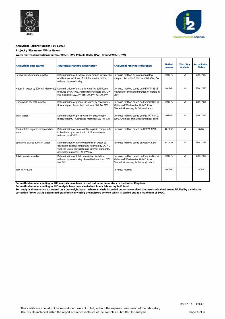
Analytical Report Number : 14-63914
Project / Site name: White Haven
Water matrix abbreviations: Surface Water (SW) Potable Water (PW) Ground Water (GW)
Analytical Test Name Analytical Method Description Analytical Method ReferenceMethod
number
Wet / Dry
Analysis
Accreditation
Status
Hexavalent chromium in water Determination of hexavalent chromium in water by
acidification, addition of 1,5 diphenylcarbazide
followed by colorimetry.
In-house method by continuous flow
analyser. Accredited Matrices SW, GW, PW.
L080-PL W ISO 17025
Metals in water by ICP-MS (dissolved) Determination of metals in water by acidification
followed by ICP-MS. Accredited Matrices: SW, GW,
PW except B=SW,GW, Hg=SW,PW, Al=SW,PW.
In-house method based on MEWAM 1986
Methods for the Determination of Metals in
Soil""
L012-PL W ISO 17025
Monohydric phenols in water Determination of phenols in water by continuous
flow analyser. Accredited matrices: SW PW GW
In-house method based on Examination of
Water and Wastewater 20th Edition:
Clesceri, Greenberg & Eaton (skalar)
L080-PL W ISO 17025
pH in water Determination of pH in water by electrometric
measurement. Accredited matrices: SW PW GW
In-house method based on BS1377 Part 3,
1990, Chemical and Electrochemical Tests
L005-PL W ISO 17025
Semi-volatile organic compounds in
water
Determination of semi-volatile organic compounds
in leachate by extraction in dichloromethane
followed by GC-MS.
In-house method based on USEPA 8270 L070-UK W NONE
Speciated EPA-16 PAHs in water Determination of PAH compounds in water by
extraction in dichloromethane followed by GC-MS
with the use of surrogate and internal standards.
Accredited matrices: SW PW GW
In-house method based on USEPA 8270 L070-UK W ISO 17025
Total cyanide in water Determination of total cyanide by distillation
followed by colorimetry. Accredited matrices: SW
PW GW
In-house method based on Examination of
Water and Wastewater 20th Edition:
Clesceri, Greenberg & Eaton (Skalar)
L080-PL W ISO 17025
TPH in (Water) In-house method L070-PL NONE
For method numbers ending in 'UK' analysis have been carried out in our laboratory in the United Kingdom.
For method numbers ending in 'PL' analysis have been carried out in our laboratory in Poland.
Soil analytical results are expressed on a dry weight basis. Where analysis is carried out on as-received the results obtained are multiplied by a moisture
correction factor that is determined gravimetrically using the moisture content which is carried out at a maximum of 30oC.
This certificate should not be reproduced, except in full, without the express permission of the laboratory.
The results included within the report are representative of the samples submitted for analysis.
Iss No 14-63914-1
Page 4 of 4

R. G. Parkins & Partners Ltd Jefferson Park January 2015
APPENDIX VIII ORIGIN OF TIER I VALUES

R. G. Parkins & Partners Ltd Jefferson Park January 2015
ORIGIN OF E3P TIER I VALUES
Constituent Origin of Risk Assessment Value
Arsenic 2009 SGV
Cadmium LQM CIEH 2nd Edition 2009
Chromium LQM CIEH 2nd Edition 2009
Lead
Residential Half 2003 EA SGV based on planned target blood lead level reduction to 5µg/l.
Commercial Calculated using commercial exposure equation within lead SGV 2003 with revised input data from HPA and taking proposed blood lead levels into account.
Mercury 2009 SGV
Nickel 2009 SGV
Selenium Soil guideline value, DEFRA/Environment Agency
Copper LQM CIEH 2nd Edition 2009
Zinc LQM CIEH 2nd Edition 2009
Cyanide - Total CLEA 1.06 Derived Value
Phenols - Total. LQM CIEH 2nd Edition 2009 – 1% SOM
Naphthalene
General Assessment Criteria (GAC) developed by CIEH / LQM the using CLEA 1-06 with supporting data from SR3, SR7 and existing Tox report where applicable. 1% SOM
Acenaphthylene
Acenaphthene
Fluorene
Phenanthrene
Anthracene
Fluoranthene
Pyrene
Benzo(a)Anthracene(
Chrysene
Benzo(b/k)Fluoranthene (iii)
Benzo(a)Pyrene
Indeno(123-cd)Pyrene
Dibenzo(a,h)Anthracene
Benzo(ghi)Perylene
TPH C5-C6 (aliphatic)
TPH C6-C8 (aliphatic)
TPH C8-C10 (aliphatic)
TPH C10-C12 (aliphatic)
TPH C12-C16 (aromatic)
TPH C16-C21 (aromatic)
TPH C21-C35 (aromatic)

R. G. Parkins & Partners Ltd Jefferson Park January 2015
APPENDIX IX GEOTECHNICAL TESTING

LABO RATO RY REPO RT
4043
Contract Number: PSL14/6189
Client’s Reference: 10365 Report Date: 05 December 2014 Client Name: E3P
Heliport Business Park Liverpool Road Eccles Manchester M30 7RU
For the attention of: Alex Smith Contract Title: Jefferson Park, Whitehaven
Date Received: 24/11/2014 Date Commenced: 24/11/2014 Date Completed: 05/12/2014 Notes: Observations and Interpretations are outside the UKAS Accreditation
* Denotes test not included in laboratory scope of accreditation $ Denotes test carried out by approved contractor
5 – 7 Hexthorpe Road, Hexthorpe, Doncaster DN4 0AR
tel: +44 (0)844 815 6641 fax: +44 (0)844 815 6642 e-mail: [email protected] awatkins
A copy of the Laboratory Schedule of accredited tests as issued by UKAS is attached to this report. This certificate is issued in accordance with the accreditation requirements of the United Kingdom Accreditation Service. The results reported herein relate only to the material supplied to the laboratory. This certificate shall not be reproduced in full,
without the prior written approval of the laboratory.
Checked and Approved Signatories: R Gunson A Watkins M Beastall (Director) (Director) (Laboratory Manager) D Lambe S Royle
(Senior Technician) (Senior Technician) Page 1 of
@prosoils.co.uk

SUMMARY OF LABORATORY SOIL DESCRIPTIONS
Hole Sample Sample Depth Description of Sample
Number Number Type m
WS101 U 1.50-2.00 Stiff brown mottled grey very gravelly sandy CLAY.
WS102 D 1.00 Brown sandy silty CLAY.
Compiled by Date Checked by Date Approved by Date
05/12/14 05/12/14 05/12/14
Contract No:
Client Ref:JEFFERSON PARK, WHITEHAVEN.
PSL14/6189
10365
Page of .

SUMMARY OF SOIL CLASSIFICATION TESTS(B.S. 1377 : PART 2 : 1990)
Moisture Bulk Dry Particle Liquid Plastic Plasticity %Hole Sample Sample Depth Content Density Density Density Limit Limit Index Passing Remarks
Number Number Type m % Mg/m3 Mg/m3 Mg/m3 % % % .425mm
Clause 3.2 Clause 7.2 Clause 7.2 Clause 8.2 Clause 4.3/4.4 Clause 5.3 Clause 5.4
WS102 D 1.00 30 47 23 24 100
SYMBOLS : NP : Non Plastic * : Liquid Limit and Plastic Limit Wet Sieved.
Compiled by Date Checked by Date Approved by Date
05/12/14 05/12/14 05/12/14
PSL14/6189
10365
Intermediate plasticity CI.
JEFFERSON PARK, WHITEHAVEN.Contract No:
Client Ref:
PSLR002 Issue 1 Jun 06 Page of .

PLASTICITY CHART FOR CASAGRANDE CLASSIFICATION.(B.S.5930 : 1999)
Compiled by Date Checked by Date Approved by Date
05/12/14 05/12/14 05/12/14
PSL14/6189
10365JEFFERSON PARK, WHITEHAVEN.
Contract No:
Client Ref:
0
10
20
30
40
50
60
70
80
90
0 10 20 30 40 50 60 70 80 90 100 110 120 130
Liquid Limit (LL%).
Pla
stic
ity In
dex
(PI%
).
CL CI CH CV CE
ML MI MH MV ME
PSLR002 Issue 1 Jun 06 Page of .

Hole Number: WS101 Depth (m):
Sample Number: Sample Type:
85.0 210.0 Test: Undisturbed
Specimen Moisture Bulk Dry Cell Corr. Max. Shear Failure Mode
Content Density Density Pressure Deviator Strength Strain of Sample taken from top of tube
(%) (Mg/m3) (Mg/m3) (kPa) Stress Cu (%) Failure Rate of strain = 2 %/min
(kPa) (kPa) Latex Membrane used 0.2 mm thickness,
ff Correction applied 0.44 kPa
A 15 2.07 1.80 17.5 200 100 4.3 Brittle
Checked Date Approved Date
05/12/14 05/12/14
JEFFERSON PARK, WHITEHAVEN.Contract No:
See summary of soil descriptions.
Height (mm): 100 mm Single Stage.
Remarks
PSL14/6189
Undrained Shear Strength in Triaxial Compressionwithout measurement of Pore Pressure
B.S. 1377 : Part7 : Clause 8 : 1990
Diameter (mm):
1.50-2.00
U
0.00
50.00
100.00
150.00
200.00
250.00
0 5 10 15 20 25
Axial Strain %
Dev
iato
r S
tres
s k
Pa
PSLR031 Issue 1 Jun 06 Page of .