Embed Size (px)
Citation preview
The Updated Philippine National Action Plan
to Combat Desertification, Land Degradation and Drought (DLDD)
FY 2010‐2020
January 2010
Department of Agriculture Bureau of Soils and Water Management
Department of Agrarian Reform
Department of Environment and Natural Resources
Department of Science and Technology
1
Table of Contents Message Foreword List of Acronyms List of Tables List of Figures Executive Summary CHAPTER I.0. Introduction
1.1 United Nations Convention to Combat Desertification (UNCCD) and the Philippines as a Party to the Convention: An Overview
1.2 Linkage of UNCCD to other Global Efforts 1.2.1 United Nations Convention on Biological Diversity 1.2.2 United Nations Framework Convention on Climate Change
1.2.3. United Nations Millennium Development Goals 1.2.4. Medium‐Term Philippine Development Plan (MTPDP) 1.3. Relevance of UNCCD to Philippine Agriculture 1.4 Overview of the Philippine NAP 2004‐2010
CHAPTER 2.0 Rationale for Preparing the Philippine NAP 2010 ‐ 2020 CHAPTER 3.0. Philippine Scenario on Land Degradation and Drought
3.1 Bio‐physical Condition of Relevant Ecosystems 3.1.1 Land 3.1.1.1 Historical Analysis of Land Degradation Scenario 3.1.1.2 Land Use Change and Productivity 3.1.1.3 Deforestation 3.1.2 Water 3.1.2.1 Drought 3.1.2.2 Water Resources Distribution, Use and Quality 3.2 Socio‐economic Condition of Affected Population 3.2.1 Poverty Incidence in the Philippines 3.2.2 Food Consumption and Malnutrition 3.2.3 Access to Water Supply Services 3.3 Policy and Legislative Efforts to Address Desertification, Land Degradation and Drought
Issues
CHAPTER 4.0. The Philippine National Development Framework based on the UNCCD’s 10‐Year Strategic Plan and Framework or “The Strategy”
4.1 Over‐all Development Framework 4.2 Characters of the Philippine NAP 2010‐2020
4.3 Goals and Objectives
4.4 Projects by Thematic Clusters
2
CHAPTER 5.0. Implementation Arrangements
5.1 Project Management and Coordination 5.2 Tentative Schedule of Programs and Projects’ Implementation
Chapter 6.0. Monitoring and Evaluation Chapter 7.0 Expected Outputs
7.1 Attainment of the Strategic Objectives in the Long‐Term 7.2 Attainment of the Operational Objectives in the Short‐Term
ANNEXES Annex 1: Past, Current and Continuing Efforts Related to Philippine NAP 2004‐2010 Annex 2: Drought‐Prone Provinces and Areas Experiencing Seasonal‐Aridity Annex 3: Relevant Laws, Legislations and Policies Addressing the Underlying Factors Causing
Massive Land Degradation in the Philippines
Glossary of Terms References Acknowledgment
3
Message The Department of Agriculture through the Bureau of Soils and Water Management had reached another milestone in addressing the triple challenges of food security, livelihood creation and environmental sustainability. I am honored to present this crucial and updated blueprint, The Philippine National Action Plan (NAP) to Combat Desertification, Land Degradation and Drought (2010‐2020). In the past decades, our strategies to enhance productivity in food‐producing areas were centered on the massive usage of inorganic fertilizers that resulted to various forms of land degradation. Inasmuch as the gradual deterioration of our lands as well as water system is already creating havoc in achieving our target production volume, thus affecting the national goal of food security and enhanced farm income, it is imperative to take serious and doable actions now. We cannot afford to be on a wait and see attitude. What is at stake is not only the current need to provide food for every Filipino household but also to ensure that future generations can have adequate food supply, clean environment, and a higher quality of life than what we have now. I have always believed that healthy land and soil is the foundation of agricultural productivity and ecosystem balance. Healthy soils can produce safe food and feed crops that promote the health of humans, animals, and other living things. With this as a guiding principle, the implementation of sustainable land and water management (SLM) program of the NAP can serve as the key to ensure that agriculture can continue to perform its major function: to provide food for the current and future Filipino population with less negative impacts to our finite land and water resources. One of the key activities under the SLM program would include the promotion of organic agriculture and upland development. As I embark on my new challenging task, I look forward in immediately implementing this plan in collaboration with our three countryside partners: Department of Agrarian Reform (DAR), Department of Environment and Natural Resources (DENR), and Department of Science and Technology (DOST). I therefore enjoin the active participation and support of other DA bureaus and attached agencies, regional field units (RFUs), local government units (LGUs), farmer’s group, academe and civil society organizations. Let us put this plan into a real action for the benefit of the Filipino people, particularly those that are vulnerable to desertification, land degradation and drought. Again, I commend the Bureau of Soils and Water Management, as the UNCCD Philippine Focal Agency, for spearheading the updating of the NAP to combat DLDD. I would also like to thank our partners from other institutions who engaged actively on our series of consultation meetings and workshops. Congratulations and more power!
Hon. Proceso J. Alcala Secretary Department of Agriculture
4
Message Greetings!!! As we usher into a new decade, I am applauding the efforts of the Department of Agriculture, particularly the Bureau of Soils and Water Management and the collaborating agencies in coming up with the updated Philippine National Action Plan (2010‐2020) in accordance to the 10‐Year Strategic Plan and Framework of the United Nations Convention to Combat Desertification (UNCCD). The problem caused by land degradation is a vicious cycle that affects our environment, economy, and society. The loss of natural resources hampers the economic development and social stability of a country. Unless we address these concerns, these conditions result to increasing level of poverty incidence and food insecurity. With the alarming state of global land degradation, the Department of Agriculture through BSWM has continually pursued the fight against desertification, land degradation, and drought (DLDD). New strategies are also being implemented to support integrated programs of land and water management that will help our farmers improve the productivity and sustainability of land and water resources. Our country has seen the havoc caused by El Niño which significantly affected our agricultural productivity. We face the challenges of climate change and human‐induced land degradation. This updated National Action Plan is a call to unite and strengthen the convergence of actions among various stakeholders to prevent desertification and land degradation and mitigate the negative impacts of drought. Our combined efforts would certainly contribute to the reduction of poverty and hunger in the countryside. Again, I commend the people behind this important milestone. Congratulations and more power! Hon. Bernie G. Fondevilla Former Secretary Department of Agriculture
5
Foreword It is my honor to present the updated Philippine National Action Plan (NAP) to Combat Desertification, Land Degradation and Drought 2010‐2020. This document affirms our continued support to the goals and objectives of the United Nations Convention to Combat Desertification (UNCCD). Like in the first NAP (2004‐2010), this updated version emphasizes the need for synergy among the three UN conventions –UNCCD, United Nations Convention on Biological Diversity (UNCBD), and the United Nations Framework Convention on Climate Change (UNFCCC) as well as the convergence of actions among stakeholders ‐ national government agencies (NGAs), local government units (LGUs), and civil society organizations (CSOs). Considering the country’s increasing vulnerability to drought and land degradation on account of poor watershed and land management, increasing population, continuing loss of productivity and decline in water availability, the NAP 2010‐2020 provides a National Development Framework to halt the further spread of desertification, prevent land degradation, and mitigate the impacts of drought in order to contribute to the global efforts on poverty reduction and to ensure environmental sustainability. The NAP underwent various consultations and workshops nationwide, including island‐wide consultations in Luzon, Visayas, and Mindanao. This document, therefore, represents the consolidated efforts of government agencies, academe, and civil society organizations in the country which are working on agriculture and natural resources use and development. We at the Bureau of Soils and Water Management (BSWM) would like to thank and commend all those who have contributed in the preparation of the updated NAP 2010‐2020. We certainly are looking forward to working with you in the implementation of the NAP 2010‐2020. SILVINO Q. TEJADA, CESO III BSWM Director and UNCCD National Focal Point
6
List of Acronyms
ACIAR Australian Centre for International Agricultural ResearchADB Asian Development Bank AFMA Agriculture and Fisheries Modernization Act of 1997 (Republic Act 8435) ARBs Agrarian Reform BeneficiariesARCs Agrarian Reform CommunitiesARRM Autonomous Region for Muslim MindanaoASEAN Association of Southeast Asian NationsASSOD Assessment of Human‐Induced Soil Degradation in South and Southeast Asia AWD Alternate‐Wetting and DryingAWS Automatic Weather StationBAR Bureau of Agricultural ResearchBSWM Bureau of Soils and Water ManagementBAS Bureau of Agricultural StatisticsBUCAF Bicol University College of Agriculture and ForestryCAR Cordillera Autonomous RegionCARP Comprehensive Agrarian Reform ProgramCBFM Community‐Based Forest ManagementCFS Climate Field School CFV Conservation Farming VillagesCHED Commission on Higher EducationCIS Communal Irrigation SystemsCOP Conference of the Parties CRIC Committee for the Review of the Implementation of the ConventionCSO Civil Society Organizations DA Department of Agriculture DA‐AFIS Department of Agriculture–Agriculture and Fisheries Information Service DA‐ITCAF Department of Agriculture Information Technology Center for Agriculture and Fisheries DAR Department of Agrarian ReformDENR Department of Environment and Natural ResourcesDILG Department of Interior and Local GovernmentDLDD Desertification, Land Degradation and DroughtDOST Department of Science and TechnologyENSO El Niño Southern OscillationESSC Environmental Science for Social ChangeFAs Farmers’ Associations FAO Food and Agriculture OrganizationFIS Forestry Information SystemFPLC Farmer’s Participatory Learning CentersFWS Farmer Water School GAA General Appropriations ActGEF Global Environmental FacilityGFDRR Global Facility for Disaster Risk ReductionGIS Geographic Information SystemGM Global Mechanisms IAs Irrigators’ Association IACDLDD Inter‐Agency Committee on Desertification, Land Degradation and Drought IEC Information, Education and CommunicationInfRES Infrastructure for Rural Productivity Enhancement SectorIPs Indigenous Peoples

7
ISCAF Ifugao State College of Agriculture and ForestryIWRM Integrated Water Resource ManagementJICA Japan International Cooperation AgencyLADA Land Degradation AssessmentLGU Local Government Unit MDG Millennium Development GoalsMOU Memorandum of UnderstandingMTPDP Medium Term Philippine Development PlanMTPIP Medium Term Philippine Investment PlanNAMRIA National Mapping Resource and Information AgencyNAP National Action Plan NAPA National Adaptation Program of ActionsNAPC National Anti‐Poverty CommissionNBSAP National Biodiversity Strategy and Action PlanNEDA National Economic Development AuthorityNDS National Development StrategyNGAs National Government AgenciesNGOs Non‐government OrganizationNIA National Irrigation AdministrationNIPAS National Integrated Protected Areas SystemNIS National Irrigation Systems NPSC National Project Steering CommitteeNSCB National Statistical Coordination BoardNWRB National Water Resources BoardPAGASA Philippine Atmospheric, Geophysical and Astronomical Services Administration PCARRD Philippine Council for Agriculture, Forestry and Natural Resources Research and DevelopmentPhilRice Philippine Rice Research InstitutePIA Philippine Information AgencyPIDS Philippine Institute for Development StudiesRS Remote Sensing SAFDZ Strategic Agriculture and Fisheries Development ZonesSLM Sustainable Land ManagementSOTER Soils and Terrain Digital DatabaseSSIPs Small Scale Irrigation ProjectsSSIS Small‐Scale Irrigation SystemsSUCs State Universities and CollegesTPN Thematic Programme NetworkTWG Technical Working Group UNCBD United Nations Convention on Biological DiversityUNCCD United Nations Convention to Combat DesertificationUNFCCC United Nations Framework Convention on Climate ChangeUNICEF United Nations Children’s FundUPLB University of the Philippines Los BañosUPRIIS Upper Pampanga River Integrated Irrigation SystemWB World BankWHO World Health Organization WRI World Resources Institute WST Water Saving Technologies
8
List of Tables Number
Title Page
1 Significant Events on Natural Resource Use and Agricultural Development in the Philippines
2 Distribution of Erosion Classes by Island Grouping (in M Ha) 3 Types of Land Degradation Based on SOTER/ASSOD Studies 4 Yearly Trend and Ratio of N, P, K, Utilization from 1980‐1998 5 Areas affected, Degree of Severity and Damages of Major ENSO‐
Induced Drought Events in the Philippines 6 Production Losses, Value of Damages and Area Affected Due to 1982‐1983,
1991‐1992, 1997‐1998 El Nino Episodes 7 Percentage Change in Livestock and Poultry Population in 1997‐1998 El Nino
Episode 8 Production Losses of the Fisheries Sector Due to 1997‐1998 El Nino Episode 9 Location and Drainage Area of Major River Basins in the Country 10 List of Priority Programs and Projects Under the Phil NAP 2010‐2020 11 Tentative Schedule of Implementation, Proposed Budget, and Agencies Involved
per Project per Thematic Cluster 12 Phil NAP 2010‐2020 Logical Framework
9
List of Figures
No. Title Page 1 Synergy of the Three Conventions within the Global Context 2 Estimated Percent Forest Cover of the Philippines 1990, 1998, 2010 3 Climate Map of the Philippines based on the Modified Corona Classification 4 El Niño Episodes in the Philippines 5 Map of the Major River Basins of the Philippines 6 Overall Development Framework of the Phil NAP 2010‐2020 to Enhance the
Implementation of the Convention
7 Synergy Among the Three Conventions at the Country Level, Overlaps Indicate the Common Thematic Areas for Possible Synergy
8 Proposed Organizational Structure to Implement the Phil NAP 2010‐2020 through Synergy among the UNCCD, UNCBD, UNFCCC and Convergence of Action and Strategic Alliance Among Various Stakeholders
10
Executive Summary The Philippine Senate ratified the UNCCD (National Action Plan to Combat Desertification) on February 10, 2000 and the final accession to the Convention came into full force in May 2000. To fulfill the requirement of UNCCD under the Convention’s Articles 9 and 10, the first Philippine National Action Plan (NAP) 2004‐2010 was formulated in August 2004. It is a working document for the convergence of actions of the Department of Agriculture (DA), Department of Environment and Natural Resources (DENR), Department of Agrarian Reform (DAR), and the Department of Science and Technology (DOST).
Recent development in the global arena and the constraints and challenges during the implementation of the programs and projects under the NAP 2004‐2010 bring about the need for updating the NAP. At the eight session of the Conference of the Parties (COP8) to the UNCCD in September 2007, country Parties adopted the 10‐Year Strategic Plan and Framework (The Strategy) 2008‐2018 to enhance the implementation of the Convention. As the Philippines’ expression of support to this new development, the NAP 2010‐2020 is formulated to more effectively implement programs and projects to combat desertification and land degradation and, mitigate the effects of drought. The big challenge that the NAP 2010‐2020 intends to address is the approximately 5.2 M (million) hectares (or 17% of the country’s total land area) of severely eroded area and the 27.3% vulnerable area to drought, alternating with floods and typhoons on a yearly basis. This situation may contribute to increasing level of poverty incidence. The NAP 2010‐2020, therefore, is a working document for the synergy among the three Multilateral Environmental Agreements (MEAs) on biodiversity, climate change and land degradation at the country level, and the convergence of actions among national government agencies (NGAs), local government units (LGUs), and civil society organizations (CSOs) to contribute to hunger mitigation and poverty reduction, and environmental sustainability.
1. The geographical domain and priority landscapes are Desertification, Land Degradation and Drought (DLDD) vulnerable areas in: highland, hillyland and upland ecosystems in which climatic drivers and human‐induced activities result to land degradation and loss of biodiversity; and
2. Lowland ecosystems which experience seasonal aridity and drought that could result to low productivity and reduced farm income.
Moreover, it is a land‐ and water‐centered action plan consisting of three long‐term strategic thematic programs, namely:
1. Creation of livelihood to affected population; 2. Sustainable use and management of affected ecosystems; and 3. Formulation of a national adaptation platform to climate change for food security and improved
resilience to natural disasters. This will be achieved through short‐ to medium‐term operational thematic clusters:
1. Sustainable Land Management (SLM) Technologies including Adaptation; 2. Capacity Building and Awareness; 3. Knowledge Management and Decision Support; 4. DLDD and SLM Monitoring and Assessment; 5. Policy, Legislative, and Institutional Framework; 6. Funding and Resource Mobilization; and
11
7. Participation, Collaboration, and Networking. Some of the expected outputs of the NAP 2010‐2020 include:
• Generation of 15,750 hectares (ha) of new areas for upland agriculture to benefit about 7,500 upland farmers through the provision of rainwater harvesting in the uplands of Ilocos Region and the Visayas Islands;
• Rehabilitation of 6,100 ha to benefit 4,200 farmers through the repair and improvement of existing small‐scale irrigation projects (SSIPs) in the upland ecosystem;
• Management of 130,000 ha of critical watershed areas of existing national irrigation systems and communal irrigation systems;
• Establishment of 126 agro‐meteorological stations in strategic upland areas and 126 early warning systems for lowland population preparedness;
• Reduction of usage of chemical fertilizers in about 200,000 ha through farm wastes recycling and reuse, and on‐farm composting technologies;
• Water savings of about 15 to 30% in irrigated rice production areas of 1.5 M ha;
• Networks of Model Farms cum Farmer Participatory Learning Centers (FLPC) in 16 Regions of the country to cater vulnerable areas to DLDD;
• Compendium of indigenous knowledge and best practices and technologies relating to sustainable resource utilization; knowledge products such as brochures and manuals on drought mitigating measures and land degradation prevention; and flyers/bulletins on early warning system and advisory on the occurrence, intensity and duration of El Niño effects and other calamities;
• Compendium of bio‐references for the selection of suitable agricultural commodities for agro‐biodiversity and forest development;
• Optimum utilization of seasonal climate and water resources information and forecasts and empowered farmers in affected areas through Climate Field School (CFS) and Farmer Water School (FWS); and
• Digital maps on DLDD hotspots and land use changes due to impacts of SLM adoption.
12
CHAPTER 1.0 Introduction
1.0 United Nations Convention to Combat Desertification (UNCCD) and the Philippines as a
Party to the Convention: An Overview
The United Nations Convention to Combat Desertification (UNCCD), adopted on June 17, 1994, is a special United Nation (UN) agenda for poverty reduction in the dry, arid, semi‐arid, and dry sub‐humid areas, particularly the African Continent. The most vulnerable ecosystems and people in the world exist in this region. As of November 2008, there were 193 Signatory States and Parties to the Convention. It was one of the three ‘Rio’ conventions borned out of the 1992 United Nations Conference on Environment and Development. The other Rio conventions were: the United Nations Framework Convention on Climate Change (UNFCCC) and the United Nations Convention on Biological Diversity (UNCBD).
Within the context of the Convention, desertification is defined as degradation of drylands. It involves the loss of biological or economic productivity, and complexity in croplands, pastures, and woodlands. It is due mainly to climate variability, and unsustainable human activities. By definition of the Convention, drylands have limited freshwater supplies where precipitation can vary greatly during the year with wide fluctuations occurring over years and decades, frequently leading to drought. Through the intervention of the Philippines, the emerging climate phenomenon attributed to the increasing recurrence cycle of El Niño, seasonal aridity or seasonal extreme dryness, was accepted in the Convention and was considered as the primary basis for the acknowledgment of desertification in the tropical countries, particularly in the Association of Southeast Asian Nations (ASEAN) country parties. The Philippine Senate and House of Representatives jointly ratified the UNCCD on February 10, 2000 and final accession came to full force in May 10, 2000. 2.0 Linkage of UNCCD to Other Global Efforts
2.1 United Nations Convention on Biological Diversity and United Nations Framework Convention on
Climate Change
The UNCCD is closely linked with the other two UN Conventions: UNCBD and UNFCCC. The UNCBD recognizes that biological diversity is about more than plants, animals, micro‐organisms, and their ecosystems. It is about people and our need for food security, medicines, fresh air and water, shelter, and a clean and healthy environment in which to live. This Convention was signed by 150 government leaders at the 1992 Rio Earth Summit. The Philippines joined the UNCBD in October 1993 and formulated its National Biodiversity Strategy and Action Plan (NBSAP) in 1997.
With 192 member‐countries, the UNFCCC sets an overall framework for inter‐governmental efforts to tackle the challenge posed by climate change. It recognizes that the climate system is a shared resource, whose stability can be affected by industrial and other emissions of carbon dioxide and other greenhouse gases. The governments that are Parties to the Convention are expected to carry out the following responsibilities:
13
• Gather and share information on greenhouse gas emissions, national policies, and best practices;
• Launch national strategies for addressing greenhouse gas emissions and adapting to expected impacts, including the provision of financial and technological support to developing countries; and
• Cooperate in preparing for adaptation to the impacts of climate change. As a Party to the Convention since August 1994, the Philippines developed the National Adaptation Program of Action (NAPA) to mitigate the effects of climate change. With the approval of the Republic Act 9729 or the Climate Change Act of 2009, the Climate Change Commission in consultation with various stakeholders, formulated the National Framework Strategy on Climate Change (2010‐2022).
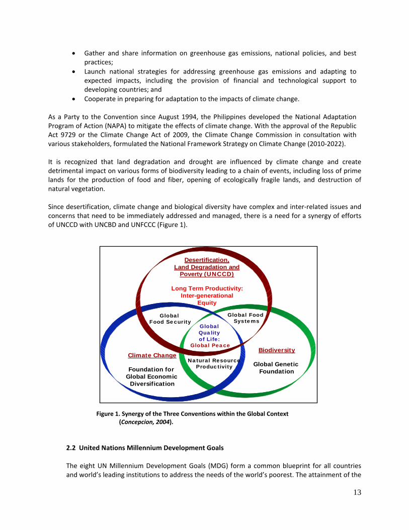
It is recognized that land degradation and drought are influenced by climate change and create detrimental impact on various forms of biodiversity leading to a chain of events, including loss of prime lands for the production of food and fiber, opening of ecologically fragile lands, and destruction of natural vegetation.
Since desertification, climate change and biological diversity have complex and inter‐related issues and concerns that need to be immediately addressed and managed, there is a need for a synergy of efforts of UNCCD with UNCBD and UNFCCC (Figure 1).
2.2 United Nations Millennium Development Goals
The eight UN Millennium Development Goals (MDG) form a common blueprint for all countries and world’s leading institutions to address the needs of the world’s poorest. The attainment of the
Desertification, Land Degradation and
Poverty (UNCCD)
Long Term Productivity:Inter-generational
Equity
Climate Change
Foundation for Global Economic
Diversification
Biodiversity
Global Genetic Foundation
Global Food Security
Global Food Systems
Natural ResourceProductivity
Global Quality of Life:
Global Peace
Figure 1. Synergy of the Three Conventions within the Global Context (Concepcion, 2004).
14
following goals is set by 2015: a) end poverty and hunger; b) universal education; c) gender equality; d) child health; e) maternal health; f) combat HIV/AIDS; g) environmental sustainability; and h) global partnership.
Among these goals, the efforts of UNCCD are channeled to address environmental sustainability and reduce poverty and hunger. Under Goal 1, the target is to reduce the proportion of people living on less than US$1 a day to half the 1990 level by 2015, that is, from 28.3% to 14.2%. This Goal also calls for bringing into half the proportion of people who suffer from hunger between 1990 and 2015. Under Goal 7, the UN seeks to integrate the principles of sustainable development into country policies and programs and reverse the loss of environmental resources and reduce biodiversity loss, achieving, by 2010, a significant reduction in the rate of loss.
2.3 Medium‐Term Philippine Development Plan (MTPDP) 2004‐2010
The MTPDP 2004‐2010 serves as the guiding document for all development efforts in the country. The Plan consists of five parts: Part I: Economic Growth and Job Creation; Part II: Energy; Part III: Social Justice and Basic Needs; Part IV: Education and Youth; and Part V: Anti‐Corruption and Good Governance. Among the sectors presented in the MTPDP, the most relevant to the Phil NAP formulation are the agribusiness and environment and natural resources. For agribusiness, one key strategy is the development of 2 M ha of new lands to enhance productivity and income of Filipino farmers living in marginal lands. For the environment and natural resources management, it is emphasized that watershed and ecosystems approach provides an effective framework and paradigm for its sustainability.
3.0 Relevance of UNCCD to Philippine Agriculture
The participation of the Philippines and other tropical countries shall focus on the prevention of the further spread of land degradation leading to desertification and the reduction of the impacts of drought and El Niño phenomenon on the loss of land productivity, especially in areas occupied by food insecure communities.
Over the decade, there is an increasing cycles of drought and El Niño in the country. More and more provinces in the Philippines are suffering from a new emerging climate phenomenon called seasonal aridity. The Philippines, particularly the small island provinces, has become vulnerable to drought and land degradation due to inadequate and inefficient irrigation systems, increasing population and rural poverty, poor land and watershed management, and increasing incidence of El Niño and La Niña.
Accelerated land use conversions, such as urbanization, deforestation coupled with unsustainable land use practices, contribute to widespread use of marginal lands by subsistence farmers leading to expansion of degraded and infertile lands.
4.0 Overview of the Philippine NAP 2004‐2010
To fulfill the requirement of the UNCCD under its Articles 9 and 10, the first Phil NAP was formulated in August 2004. It is a working document for the convergence of actions of the
15
Department of Agriculture (DA), Department of Environment and Natural Resources (DENR), Department of Agrarian Reform (DAR), and the Department of Science and Technology (DOST). The Phil NAP 2004‐2010 is a water‐centered action plan and is focused on sustainable management of critical watershed areas located in seasonally dry/arid areas suffering from food insecurity. These critical watershed areas have highly threatened river systems that cut across two or more municipalities and provinces where initiatives of local government units and their respective communities need to be guided and harmonized. These inter‐related problems, through the NAP, sought the participation and collective efforts of the DA, DENR, DAR, and DOST. The Phil NAP 2004‐2010 has two major thematic programs, namely: Sustainable Agriculture and Marginal Upland Development and Integrated Ecosystem Management. These thematic programs has five components, that is, Land and Water Technology Development; Local Governance and Community Initiatives; Database Development and Harmonization; Information, Education and Communication; and Enabling Policy. As planned, the important deliverables of the Phil NAP 2004‐2010 within the implementation period are:
1. Establishment of 5,000 community learning centers for training 15,000 upland dwellers and for developing community initiatives on local area development;
2. Construction of 100,000 small water retention structures in critical watershed areas for the period 2005‐2010 to cover about 200,000 ha and benefit about 130,000 upland dwellers;
3. Reduction by 30% of farmers’ dependence on chemical fertilizers at the end of 2010 by implementing balance fertilization strategy through the proper combination of organic and inorganic fertilizers; and
4. Prevention of desertification and further expansion of land degradation through the rehabilitation of approximately 200,000 ha of degraded lands in seasonally arid areas and about 250,000 ha of forestlands.
The Phil NAP 2004‐2010 faced several challenges during its implementation. These include the lack of institutional arrangement, inadequate information and financial and manpower resources, and the overlapping programs and priorities of government agencies. Despite these challenges, efforts by both government agencies and non‐government organizations (NGOs) have contributed in achieving its objectives through their various projects that are aligned with the Phil NAP 2004‐2010. The detailed information regarding these projects is presented in Annex I and is summarized by program component as follows:
• Program Component 1: Land and Water Technology Development
1. Promotion of Water Saving Technology: Alternate‐Wetting and Drying (AWD) in Upper
Pampanga River Integrated Irrigation System (UPRIIS) and Groundwater Irrigation Project in Tarlac;
2. Japan International Cooperation Agency (JICA)‐Technical Cooperation Program I and II: Promotion of Water Saving Technology;
3. Sustainable System of Irrigated Agriculture; 4. Agri‐kalikasan‐Modified Rapid Composting Program;
16
5. National Coconut Productivity Program; 6. Hydrobiological Assessment of Lake Lanao; 7. Water Quality Monitoring Focusing on Industrial Wastewater, River Systems and Coastlines; 8. Organic‐based Agriculture – Tamang Abono Project; 9. Mercury Assessment Project; 10. Site Specific Nutrient Management for Corn Areas; 11. Community‐based Watershed Management Approach in Improving Livelihood
Opportunities in Selected Areas in the Philippines; 12. Construction of Doppler Radar Project; 13. Establishment of Automatic Weather Stations (AWS); 14. Mindanao Rural Development Program (MRDP)‐APL II (World Bank‐funded); 15. Infrastructure for Rural Productivity Enhancement Sector (InFRES)‐ Asian Development Bank
(ADB) funded; 16. Support to Emergency and Livelihood Assistance Program; and 17. Construction and Installation of Flood Forecasting and Early Warning System for Maragusan,
Compostela Valley.
• Program Component 2: Local Governance and Community Initiatives
1. Australian Center for International Agricultural Research (ACIAR) Bohol Project 1 ‐ Integrated Watershed Management for Sustainable Soil and Water Resources Management of the Inabanga Watershed, Bohol Island, Philippines;
2. ACIAR Bohol Project 2 ‐ Evaluation and Adoption of Improved Farming Practices on Soil and Water Resources, Bohol Island, the Philippines;
3. Community Agricultural Technology Project: Increasing Income of Farmer Groups through Improved Practices of Goat Production and Pasture Management;
4. Rajah Sikatuna Protected Landscape Biodiversity Conservation and Poverty Reduction Project;
5. Bilar‐Batuan Eco‐Toursim Enhancement Project; 6. Nueva Vida Sur Natural Resources Management Project ; 7. Enhancing Bat and Dipterocarp Conservation through Research and Education in Selected
Sites in Loboc, Bilar, Sevilla, Danao, and Guindulman; 8. Capacity Building and Development of Farmers’ Associations and Cooperatives in Upland
Barangays of Bohol, Philippines (Phase 3); 9. Dipterocarp Tree Domestication and Use on Public and Private Lands in Selected Sites to
Expand and Conserve Philippine Forests; 10. Cambigsi Natural Resource Management Project; 11. Capacity Building and Development of Farmer Associations in Upland Barangays of Bohol 12. Conservation of Cave Swiftlets and Sustainable Harvesting of their Nests in Karst Landscapes
of Bohol Island, Philippines; 13. Omjon Natural Resource Management Project; 14. Strengthening Integrated Natural Resource Management and Income Generation in Eskaya
Communities of Bohol, Philippines; 15. Strengthening Solid Waste Management in Bilar, Bohol; 16. Publication of Karst Information Kit for Environmental Management Decision Makers; 17. Establishment and Rehabilitation of Small‐Scale Irrigation Projects; 18. Abang Sama River Irrigation Project; 19. Upper Saug Irrigation Project;
17
20. Enhancing Agricultural Production through Sustainable Use of Shallow Groundwater; 21. National Program for Sustainable Upland Farming through the Establishment of “Barangay
Sagip Saka” ‐ Conservation Farming Villages (CFV); 22. Upland Development Program; 23. Integrated Soil Conservation Techno‐Demo Guided Farm; 24. Farmer Field School: Season‐long Participatory Training on Conservation Farming in
Different Agro‐climatic Zones; 25. Alternative Energy, Food and Livelihood Sources towards Sustainable Management of the
Bayug River Watershed, Brgy. Rogongon, Iligan City; 26. Biodiversity Research Programme for Development in Mindanao; 27. Soil Ecological Diversity and Relevant Interrelationships of Critical Resources in Mt.
Malindang, Misamis Occidental; and 28. Soil Ecological Diversity and Conservation of Critical Resources in Agusan del Sur.
• Program Component 3: Database Development and Harmonization
1. Forestry Information System (FIS) Project; 2. Intelligent Decision Support System for Environmental Hazards Management Using
Geographic Information System (GIS) and Remote Sensing (RS); and 3. Agrarian Reform Communities (ARCs) Resource Inventory (Bohol province)
• Program Component 4: Information, Education and Communication (IEC)
1. Production of audio‐video materials, articles, technical papers, manual, brochures, and
training manuals through various BSWM‐implemented Projects; 2. Watershed tours (Central Cebu Protected Landscape); 3. Development and Support for Dipterocarp Information Materials Development in the
Philippines; 4. Buhisan Dam Watershed Protection and Rehabilitation Project; and 5. 2005 Statistics on Philippine Protected Areas and Wildlife Resources.
• Program Component 5: Enabling Policy
For Program Component 5, policy research projects and studies directed on mitigating the effects of land degradation and drought have not been carried out comprehensively. However, several bills have been crafted that addressed the underlying factors causing land degradation (Annex 1 for the list of legislations).
18
CHAPTER 2.0 Rationale for Preparing the Philippine NAP 2010 ‐ 2020
As emphasized in the 7th session of the Committee for the Review of the Implementation of the Convention (CRIC7), NAP represents the core instrument for implementing the Convention. There is a need for an update of NAP through a continuing participatory process on the basis of lessons learned from field works and knowledge development. After a decade of UNCCD implementation, it has been recognized that limiting factors prevented optimal deployment of the Convention. Among these factors are insufficient financing compared to its Rio sister conventions; a weak scientific basis; insufficient advocacy and awareness among various constituencies; and institutional weaknesses and difficulties in reaching consensus among Parties. At the country level, as previously mentioned, one of the constraints encountered was the lack of adequate institutional arrangements that would enhance the effective implementation of programs and projects indicated in the Phil NAP 2004‐2010. The proposed Inter‐agency Committee on Desertification, Land Degradation and Drought (IACLDDD) was not yet created, thereby preventing the multi‐institutional program implementation. Therefore, it is imperative to create the IACLDDD and make it operational starting 2010. Another challenge is inadequate financing for the NAP’s programs and projects. Although there was an effort to seek for assistance on project development through the Operational Plan 15 (Sustainable Land Management) of the Global Environment Facility (GEF), this initiative did not push through because of the change of top‐level priorities as well as leadership. The UNCCD operates today in an environment that has evolved considerably since it was first negotiated and it faces different opportunities and constraints that will condition its implementation in the forthcoming decade. To address the Convention’s key challenges at the strategic and operational levels, at the 8th session of the Conference of the Parties (COP8) to the UNCCD in September 2007, Parties to the Convention adopted the 10‐year Strategic Plan and Framework or The Strategy 2008‐2018 to enhance the implementation of the Convention (ICCD/COP(8)/16/Add 1). The Strategy is a tool to effectively respond to new challenges and opportunities in the global context. Its purpose is “to establish a global partnership to halt and prevent desertification and land degradation and to mitigate the effects of drought in affected areas in order to support poverty reduction and environmental sustainability”. The Strategy defines and proposes priorities for the implementation of the Convention expressed in the form of four strategic objectives:
• Strategic Objective 1: To improve the living conditions of affected population • Strategic Objective 2: To improve the condition of affected ecosystem • Strategic Objective 3: To generate global benefits through effective implementation
of the Convention • Strategic Objective 4: To mobilize resources to support implementation of the
Convention through building effective partnerships between national and international actors
With a view of supporting the abovementioned strategic objectives, the following operational objectives will guide the actions of all UNCCD stakeholders and partners in the short and medium term (3‐5 years):
19
• Operational Objective 1: Advocacy, Awareness Raising and Education ‐ To actively influence
relevant international, national and local processes and actors in adequately addressing desertification/land degradation and drought‐related issues;
• Operational Objective 2: Policy Framework ‐ To support the creation of enabling environments for promoting solutions to combat desertification/land degradation and mitigate the effects of drought;
• Operational Objective 3: Science, Technology and Knowledge ‐ To become a global authority on scientific and technical knowledge pertaining to desertification/land degradation and mitigation of the effects of drought;
• Operational Objective 4: Capacity Building ‐ To identify and address capacity‐building needs to
prevent and reverse desertification/land degradation and mitigate the effects of drought; and
• Operational Objective 5: Financing and Technology Transfer ‐ To mobilize and improve the targeting and coordination of national, bilateral, and multilateral financial and technological resources in order to increase their impact and effectiveness.
Affected country Parties, therefore, should align their NAPs to The Strategy. Consistent with The Strategy, this implies the revision of the NAP; thus, there is a need to update the Phil NAP. In the updating of the NAP 2010‐2020 in support to The Strategy 2008‐2018 of UNCCD, a participatory approach was carried out in accordance with the UNCCD requirement. Articles 9 and 10 of the UNCCD state that the affected country party shall prepare and make public the NAP and specify the respective roles of government, local communities and land users, as well as the resources that are available and needed. In view of this, a series of consultation meetings and workshops were held in different parts of the country. Three island‐wide consultation‐workshops were held in Luzon, Visayas, and Mindanao. In addition, three national consultation meetings were carried out. Stakeholders such as the national government agencies (NGAs), local government units (LGUs), civil society organizations (CSOs), and academe actively contributed significant inputs for the updating of the NAP 2010‐2020.
20
CHAPTER 3.0 Philippine Scenario on Land Degradation and Drought
3.1 Bio‐Physical Condition of Relevant Ecosystems
3.1.1 Land
About 45% of the arable lands in the Philippines have been moderately to severely eroded, triggering the movement of subsistence farmers to marginal lands with the hope of meeting their day‐to‐day food requirement. Approximately 5.2 M ha are severely eroded and 8.5 M ha are moderately eroded resulting to 30‐50% reduction in soil productivity and water retention capacity. This situation will predispose the degraded lands to drought and other water availability problems. 3.1.1.1 Historical Analysis of Land Degradation Scenario
The Philippines is well endowed with natural resources and is known to host many interesting
habitats that are biologically diverse composed of universally unique biological plants and animal life.
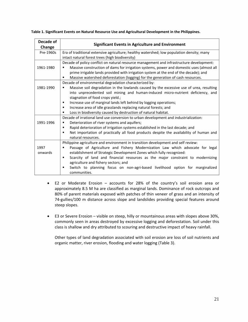
However, because of complex conditions, ranging from increasing population, isolated small islands and diverse cultures, intricate political condition, stagnation of the rural economy, and a host of other reasons, various forms, sources and severity of environmental degradation occurred in the last five decades (Table 1).
1.) Forms, Extent and Distribution of Land Degradation
a. Soil Erosion b. The most common type of land degradation in the Philippines is soil erosion which poses a detrimental effect on soil physico‐chemical and biological properties. This makes the land less suitable to crop production or in some cases of severe erosion, resulting to total loss of soil productivity. Moreover, it can disrupt utilization of public utilities.
There are various classes of soil erosion, ranging from no apparent erosion to severe erosion (Table 2).
• E0 or No Apparent Erosion – accounts for 24% of the total land area and occurs typically in
broad alluvial plains, minor alluvial plains, residual terraces, plateaus, foot slope and plains which are usually found in Region III. These areas are classified as prime agricultural lands.
• E1 or Slight Erosion – includes the formation of incipient erosion manifested by sheets,
rills and tiny incisions along trails and creeks (1 rill/100 m). Regions IV, V and VII have more than 35% of their respective areas under this class.
21
Table 1. Significant Events on Natural Resource Use and Agricultural Development in the Philippines.
Decade of Change
Significant Events in Agriculture and Environment
Pre‐1960s Era of traditional extensive agriculture; healthy watershed; low population density; many intact natural forest trees (high biodiversity)
1961‐1980
Decade of policy conflict on natural resource management and infrastructure development: Massive construction of dams for irrigation systems, power and domestic uses (almost all
prime irrigable lands provided with irrigation system at the end of the decade); and Massive watershed deforestation (logging) for the generation of cash resources.
1981‐1990
Decade of environmental degradation characterized by: Massive soil degradation in the lowlands caused by the excessive use of urea, resulting
into unprecedented soil mining and human‐induced micro‐nutrient deficiency, and stagnation of food crops yield.;
Increase use of marginal lands left behind by logging operations; Increase area of idle grasslands replacing natural forests; and Loss in biodiversity caused by destruction of natural habitat.
1991‐1996
Decade of irrational land use conversion to urban development and industrialization: Deterioration of river systems and aquifers; Rapid deterioration of irrigation systems established in the last decade; and Net importation of practically all food products despite the availability of human and
natural resources. 1997 onwards
Philippine agriculture and environment in transition development and self review: Passage of Agriculture and Fishery Modernization Law which advocate for legal
establishment of Strategic Development Zones which fully recognized: Scarcity of land and financial resources as the major constraint to modernizing
agriculture and fishery sectors; and Switch to planning focus on non‐agri‐based livelihood option for marginalized
communities.
• E2 or Moderate Erosion – accounts for 28% of the country’s soil erosion area or approximately 8.5 M ha are classified as marginal lands. Dominance of rock outcrops and 80% of parent materials exposed with patches of thin veneer of grass and an intensity of 74‐gullies/100 m distance across slope and landslides providing special features around steep slopes.
• E3 or Severe Erosion – visible on steep, hilly or mountainous areas with slopes above 30%,
commonly seen in areas destroyed by excessive logging and deforestation. Soil under this class is shallow and dry attributed to scouring and destructive impact of heavy rainfall.
Other types of land degradation associated with soil erosion are loss of soil nutrients and organic matter, river erosion, flooding and water logging (Table 3).
22
Table 2. Distribution of Erosion Classes by Region.
Region
EROSION CLASSESNo
Apparent Erosion (E0)
Slight Erosion (E1)
Moderate Erosion (E2)
Severe Erosion (E3)
Unclassified Erosion (EU)
TOTAL AREA
(Ha) (%)
LUZON 4,081,268 4,065,194 4,127,613 1,709,155 156,262 14,139,492 100.00CAR 130,367 515,825 737,134 413,729 32,313 1,829,368 12.94I 514,881 242,343 262,226 264,569 1,284,019 9.08II 726,022 374,153 1,158,953 416,644 7,986 2,683,758 18.98III 923,250 400,855 323,659 143,297 32,021 1,823,082 12.89IV 1,341,043 1,896,162 1,134,444 317,337 67,030 4,756,016 33.64V 445,705 635,856 511,197 153,579 16,912 1,763,249 12.47
VISAYAS 1,240,751 1,743,632 1,444,384 1,126,073 123,695 5,678,535 100.00VI 551,663 541,365 497,893 391,721 39,698 2,022,310 35.61VII 181,247 376,717 558,010 328,733 55,233 1,499,940 26.41VIII 507,871 825,550 388,481 405,619 28,764 2,156,285 37.97
MINDANAO 1,809,463 3,186,492 2,907,291 2,246,928 49,716 10,199,890 100.0IX 354,500 582,033 705,116 212,343 14,518 1,868,510 18.32X 330,216 964,821 920,531 603,451 13,751 2,832,770 27.77XI 529,049 1,090,510 574,877 966,174 8,680 3,169,290 31.07XII 595,698 549,128 706,767 464,960 12,767 2,329,320 22.84
Data source: Crop Development and Soils Conservation Framework ALMED, BSWM, Quezon City Table 3. Types of Land Degradation Based on SOTER/ASSOD Studies.
Region
Total No Soil Degradation
Top Soil
Erosion
Loss of Soil Nutrients
and/or Organic Matter
River Erosion Flooding Water
Logging Urbanization
Built-up Areas and Industry
Other Soil Degradation
106 ha (%) (%) (%) (%) (%) (%) (%) (%)
CAR 1.8 10.0 87.0 - 1.6 - - 0.6 0.8 I 1.2 35.1 46.0 8.7 1.9 0.2 1.4 4.0 2.7 II 2.7 24.4 63.2 6.6 - - 1.0 1.9 2.9 III 1.8 46.9 34.4 - 1.3 3.9 1.8 5.5 6.2 IV 4.8 60.3 35.0 0.3 - 0.5 - 2.7 1.2 V 1.8 20.1 73.4 - 0.4 6.5 - - 0.0 VI 2.0 51.5 35.8 10.2 - 0.1 - 1.7 0.3 VII 1.5 20.5 70.3 1.2 - 2.6 - 2.3 3.1 VIII 2.1 46.1 50.0 0.8 - 1.8 - 1.2 0.1 IX 1.6 19.3 76.7 3.2 - - - 0.4 0.4 X/Caraga 2.8 12.1 83.3 0.3 0.1 - 0.8 0.4 3.0 XI/Caraga 3.2 10.7 73.5 13.6 - 0.5 - 0.9 0.8 XII 1.5 17.3 76.6 - - 5.2 - 0.8 0.1 ARMM 1.1 23.7 73.0 - - 2.6 - 0.5 0.2 Source: Bureau of Soils and Water Management (BSWM), 1993.
23
b. Soil Mining and Decline of Soil Productivity
The long term and continued use of urea “alone” resulted in serious nutrient imbalance and contributed to the actual silent soil degradation widely known as soil mining. The general trend indicated very active soil mining where through time there is an increasing number of plant nutrients required to sustain plant growth, as follows:
1960‐1970 ‐ Nitrogen (N) fertilizer is generally required; 1970‐1980 ‐ Nitrogen plus Phosphorous (P) are generally required; and 1980‐1990 ‐ Nitrogen, Phosphorous plus Potassium (K), including micro‐nutrients (Zinc
in rice and Magnesium in corn) are generally required.
This practice contributed to the stagnation of rice yields and corn because of excessive use of nitrogen fertilizer (urea) beyond the normal ratio of 3N:1P. Table 4 shows the soil mining and nutrient imbalance between N and P from 1980 to 1998. Most pronounced imbalance was in 1991, where the N/P ratio was three times higher than the normal ratio.
The long‐term impact on soil is expressed in terms of depleted soil P, K and induced Zn deficiency. The net impact of soil mining is the increased cost of fertilization and decline in the farmers’ income.
Table 4. Yearly Trend and Ratio of N, P, K Utilization from 1980‐1998 ( metric tons per year).
YEAR N P K RATIO (N/P) 1980 224,866 53,784 55,782 4.18 1981 209,875 51,163 60,620 4.10 1982 232,840 56,139 57,435 4.15 1983 244,179 54,784 64,496 4.46 1984 180,569 45,372 38,617 3.99 1985 205,364 42,822 35,060 4.80 1986 298,323 42,771 46,267 6.97 1987 371,925 63,340 48,661 5.87 1988 372,118 77,471 54,934 4.80 1989 375,940 84,101 77,260 4.47 1990 394,767 46,188 68,512 8.55 1991 292,483 30,397 54,197 9.62 1992 331,537 36,025 61,628 9.20 1993 395,183 42,473 93,331 9.30 1994 396,751 46,920 38,944 8.46 1995 389,295 56,817 59,098 6.85 1996 462,776 65,055 90,346 7.11 1997 541,112 65,253 93,331 8.29 1998 408,778 53,299 81,740 7.67
24
2.) Causal Factors of Land Degradation
a. Natural Causes
a.1 Topographic Variations and Problem Soils The Philippines is an archipelago with topographic variations in its various islands. It has several mountains and hillylands present all over the country which are experiencing decrease in land cover; thus, making them more prone to soil erosion. Furthermore, problem soils are dominant in areas with steep slopes, poor drainage, coarse textures, and fertility limitations.
o Steep slopes – These are areas which are steeply dissected with slopes more than 30% distributed as follows:
30‐50% slope ‐ 6,293,362 ha 51% slope and up ‐ 2,609,900 ha
o Poor drainage – These are areas that are water‐logged or flooded for significant part of the year. These lands are associated with the Fluvaquents (12,800 ha) and Hydraquents (78,080 ha) that are integrated with the Tropaquents or about 0.30% of the total land area.
o Coarse textures – These are areas which have coarse textures with less than 18% clay and more than 65% sand or have gravel stones, boulders or rock outcrops in the surface layers or at the surface. These soils belong to the Tropopsamments along with other skeletal phases of other great soil groups that extend to about 482,849 ha or about 1.61% of the total land area.
o Heavy cracking clays – These are areas which have 30% or more clay to at least 50
centimeter (cm) from the surface after the upper 20 cm of soil are mixed, cracks at least 1 cm wide at 50 cm depth and high bulk density between the cracks. These are Vertisols classified as Uderts and Usterts that comprise a total land area of about 765,388 ha or almost 2.6% of the total land area.
o Severe fertility limitations – These are land areas that exhibit deficiencies in major
and minor plant nutrients when cultivated. These marginal lands belong to the Ultisols, which are formed on undulating to rolling plateau, hills and mountain areas that extend to 12,067,994 ha and the Oxisols, which are found in Palawan comprising about 26,320 ha.
o Land with saline and sodic soil limitations – Saline and sodic soils are mainly
situated in coastal areas and extend to almost 400,000 ha or about 1.33% of the total land area.
25
a.2 Volcanic Eruptions There are more than 200 volcanoes in the country and four major volcanic belts, namely: Westerly Convex Volcanic Belt, Easterly Convex Volcanic Belt, Westerly Volcanic Belt, and Southeasterly Volcanic Belt. One of the major volcanic eruptions is that of Mt. Pinatubo in 1991, emitting enormous amounts of ash‐laden steam clouds reaching as high as 20 km above the vent. An estimated 68 billion (B) cubic meter of pyroclastic materials were deposited over a 4,000 square km area, including the eight major river basins. The interim effect of this eruption is the occurrence of heavy ash falls and lahar, making vast tracts of lands planted to rice and sugarcane in Central Luzon unfit for agricultural production and, several residential areas unsuitable for human settlements. Furthermore, every year, particularly during the wet season, heavy rainfall continues to erode the pyroclastic materials deposited on the slopes of the volcano causing fast‐moving lahar to wreak havoc and severe damages on an estimated area of 300,000 ha, comprising mostly of residential communities and agricultural lands..
b. Human‐Induced Causes
The Philippine population is growing at an annual growth rate of 2.4% (NSO, 2007). This increase in population is accompanied by increasing requirements for food, clothing, and settlements. To improve crop yield, extensive use of chemical inputs such as inorganic fertilizers, herbicides and pesticides has been popularized which left the soil very acidic and unfit for production in the long run. While the demand for meat and meat products continue to increase, grazing lands for cattle, goat and other ruminants are extensively utilized. The increasing demand for human settlement and other non‐agricultural purposes has contributed to the great loss of prime agricultural lands. This resulted to the opening of ecologically fragile lands. Approximately 74% of the sloping uplands are actively used for subsistence farming in order to augment the demand for food supply and increase income. Moreover, people tend to migrate and occupy upland and marginalized areas, including the forestlands, and they practice slash and burn agriculture in order to meet their needs. The cutting down and burning of trees and grasses and basic slope cultivation without incorporating soil conservation management strategies would result to land degradation. Lands destroyed by gullying can even extend to the upper part of the watershed. In fact, a total of 13,559,492 ha have been moderately to severely affected by erosion. Contributing to the massive land degradation and watershed denudation, the abovementioned practices were done to meet the basic requirements of this generation at the expense of dwindling environmental resources, placing the sustainability of agricultural development in question.
26
c. Policy‐Related Causes
c.1 Absence of a comprehensive national land use policy
Inefficiency and improper land utilization can be attributed to the lack of a rational and comprehensive national land use policy that will ensure optimum use and management of land resources consistent with the principle of sustainable development. As of December 2009, the proposed National Land Use Act was not yet approved by the House of Representatives and Senate. Non‐delineation of these lands resulted to illegal conversions of agricultural lands to non‐agricultural lands, displacements of rural communities, and entry of commercial establishment in some ecologically fragile lands. Proving in court that the land is illegally converted would require a very long process of litigation.
c.2 Poor enforcement of existing land use policies and on prohibition of land use
conversion
Boundary between forestlands and alienable and disposable lands are not clearly delineated resulting to complication in enforcement of land use laws and monitoring of land use changes. With the help of the Local Government Units (LGUs), the DA has already delineated the Strategic Agriculture and Fisheries Development Zones (SAFDZs) as required in the implementing rules and regulations of RA 8435 (Agriculture and Fisheries Modernization Act).
Illegal logging, shifting cultivation, and encroachment of dwellers in forested areas are serious concerns. Negative effects would include low land productivity, squatting and possible establishment of industries, and settlements within ecologically critical areas.
In areas where zonings are in placed, zoning ordinances are not strictly implemented partly because of the absence of police power of concerned government agencies in enforcing land use and land conversion laws.
3.1.1.2 Land Use Change and Productivity
Rapid urbanization has resulted to indiscriminate conversion of agricultural lands to residential, industrial, and commercial uses that may undermine food security. The annual average conversion rate of agricultural lands to other uses from 1990‐2007 is estimated at 2,561 ha from the basic record extracted from DAR. This, however, has to be validated in view of unaccounted land conversion in the regional areas. Indiscriminate conversion of agricultural lands led the farmers to encroach into vulnerable and marginal upland areas for farming activities, without sustainable land management practices, thereby aggravating land degradation.
27
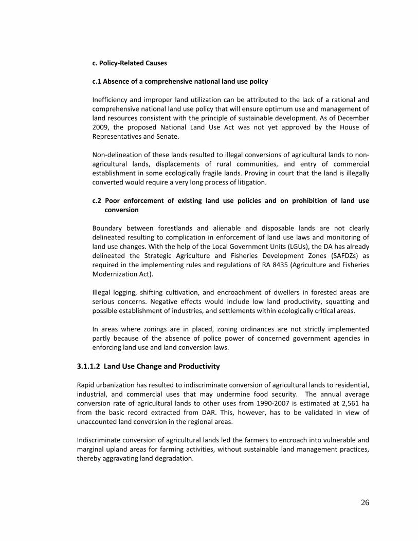
3.1.1.3 Deforestation
Clearing of forest areas to pave way for agricultural activities, indiscriminate logging and harvesting of fuel wood, and poor management of forestlands have resulted to rapid loss of forest cover. As of 2003, only about 7.2 M ha or 29% of the original forest cover remains (NAMRIA, 2003) and is projected that only 6% (Figure 2) will remain by 2010 (ESSC, 1999). Deforestation exposes marginal upland areas to accelerated land degradation and destruction of watershed areas.
3.1.2. Water
3.1.2.1 Drought Drought is a natural phenomenon that occurs when precipitation or rainfall is significantly below the recorded normal levels and consequently, affects the surface and subsurface water supply. Simply defined, it is the lack of sufficient water supply to meet the requirements for agricultural, economic, domestic, and environmental uses.
1) Distribution and Extent of Drought Hotspots
The most vulnerable areas to drought are located in the following:
a.) Areas experiencing seasonal aridity and recurrent droughts and manifest conditions and effects of desertification processes (Annex 2). These are located in the following:
• Major rice, corn and other grain‐producing and moisture‐deficit areas
specifically in:
o Northern tip of Luzon:
Figure 2. Estimated Percentage of Forest Cover of the Philippines 1990, 1998, 2010 (ESSC, 1999).
28
Region I ‐ Ilocos Sur and Ilocos Norte; and Region II ‐ Cagayan Valley.
o Mindanao: Region IX ‐ Zamboanga del Norte, Zamboanga del Sur; Region X ‐ Bukidnon, Lanao del Norte, Misamis Oriental; Region XI ‐ Davao del Sur, Davao Oriental; Region XII ‐ South Cotabato, General Santos, Sarangani; and ARMM ‐ Maguindanao,
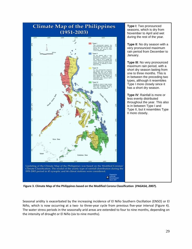
• Provinces in the western portions of the country experiencing Type 1 and Type
III climate characterized by two pronounced seasons, dry and wet, with maximum rain period from June to September due to prevalence of Southwest monsoon (Figure 3).
• Provinces in the central parts of the country experiencing Type III climate
characterized by no very pronounced wet season and with a short dry season lasting from one to three months. This closely resembles Type I climate (Figure 3).
The mean daily temperature in these areas, which, ranges from 300 to 350C and with relative humidity of 70‐80% induce depletion of soil organic matter and significant water loss through evapotranspiration. Thus, in prolonged dry periods, soil and water resources in these areas are not able to support crop production.
29
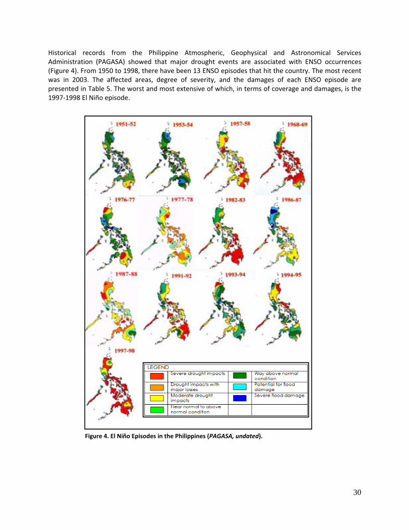
Seasonal aridity is exacerbated by the increasing incidence of El Niño Southern Oscillation (ENSO) or El Niño, which is now occurring at a two‐ to three‐year cycle from previous five‐year interval (Figure 4). The water stress periods in the seasonally arid areas are extended to four to nine months, depending on the intensity of drought or El Niño (six to nine months).
Figure 3. Climate Map of the Philippines based on the Modified Corona Classification (PAGASA, 2007).
Type I: Two pronounced seasons, which is dry from November to April and wet during the rest of the year. Type II: No dry season with a very pronounced maximum rain period from December to January. Type III: No very pronounced maximum rain period, with a short dry season lasting from one to three months. This is in between the preceding two types, although it resembles Type I more closely since it has a short dry season. Type IV: Rainfall is more or less evenly distributed throughout the year. This also is in between Type I and Type II, but it resembles Type II more closely.
30
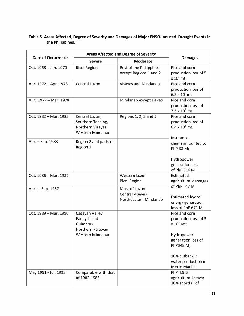
Historical records from the Philippine Atmospheric, Geophysical and Astronomical Services Administration (PAGASA) showed that major drought events are associated with ENSO occurrences (Figure 4). From 1950 to 1998, there have been 13 ENSO episodes that hit the country. The most recent was in 2003. The affected areas, degree of severity, and the damages of each ENSO episode are presented in Table 5. The worst and most extensive of which, in terms of coverage and damages, is the 1997‐1998 El Niño episode.
Figure 4. El Niño Episodes in the Philippines (PAGASA, undated).
31
Table 5. Areas Affected, Degree of Severity and Damages of Major ENSO‐Induced Drought Events in
the Philippines.
Date of Occurrence Areas Affected and Degree of Severity
Damages Severe Moderate
Oct. 1968 – Jan. 1970 Bicol Region Rest of the Philippines except Regions 1 and 2
Rice and corn production loss of 5 x 10⁵ mt
Apr. 1972 – Apr. 1973 Central Luzon Visayas and Mindanao Rice and corn production loss of 6.3 x 10⁵ mt
Aug. 1977 – Mar. 1978 Mindanao except Davao Rice and corn production loss of 7.5 x 10⁵ mt
Oct. 1982 – Mar. 1983
Central Luzon, Southern Tagalog, Northern Visayas, Western Mindanao
Regions 1, 2, 3 and 5 Rice and corn production loss of 6.4 x 10⁵ mt; Insurance claims amounted to PhP 38 M; Hydropower generation loss of PhP 316 M
Apr. – Sep. 1983 Region 2 and parts of Region 1
Oct. 1986 – Mar. 1987 Western Luzon Bicol Region
Estimated agricultural damages of PhP 47 M Estimated hydro energy generation loss of PhP 671 M
Apr . – Sep. 1987 Most of Luzon Central Visayas Northeastern Mindanao
Oct. 1989 – Mar. 1990 Cagayan Valley Panay Island Guimaras Northern Palawan Western Mindanao
Rice and corn production loss of 5 x 10⁵ mt; Hydropower generation loss of PhP348 M; 10% cutback in water production in Metro Manila
May 1991 ‐ Jul. 1993 Comparable with that of 1982‐1983
PhP 4.9 B agricultural losses; 20% shortfall of
32
Date of Occurrence Areas Affected and Degree of Severity
Damages Severe Moderate
water supply in Metro Manila
Apr. 1994 – Mar. 1995 Regions 1, 2, 3, 5, NCR, and Palawan
Visayas and Western Mindanao
May 1997 – Apr. 1998 About 70% of the Philippines experienced severe drought
Production loss of 622,106 mt of rice and 1,187,346 mt of corn amounting to about PhP 12.3 B Water shortages, forest fires, and human health impacts
May 2002 – Mar. 2003
Region VI Western Mindanao
Regions 1, 2, 3 Central Mindanao Bicol Eastern Visayas Southern Tagalog Northern Luzon
0.8% reduction in palay production in the first quarter of 2003
Sources: PAGASA, undated; De Guzman, undated; and PCARRD, 2001.
b.) Island and small‐island provinces/municipalities, particularly in the Visayas, northern and southern tip of Luzon and southern tip of Mindanao. These areas have limited land and water resources given the geological nature of most of these islands.
2) Historical Impacts of Drought and El Niño
Drought can strike at any region at any time with varying degrees of severity, depending on the intensity (degree of moisture deficiency), duration and scope. Increase recurrence of drought and El Niño resulted to loss of land productivity and crop failure, loss of biodiversity and fragile ecosystems; and even loss of human lives and properties. A summary of damages incurred due to major El Niño‐induced drought years are presented in Table 5.
a.) Agriculture and Fisheries
Prolonged droughts induced by ENSO have caused severe damages and losses to the agriculture sector. For instance, aggregated agricultural production dropped by 6.6% as a result of the 1997‐1998 El Niño (PAWB, 1999; de Guzman, undated). Recent studies by Lasco et, al., (2008) revealed that, the estimated total damages due to 1990‐2003 ENSO events amounted to US$ 370.0 M.
33
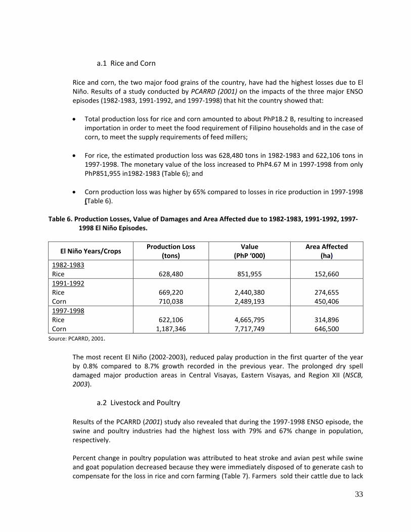
a.1 Rice and Corn
Rice and corn, the two major food grains of the country, have had the highest losses due to El Niño. Results of a study conducted by PCARRD (2001) on the impacts of the three major ENSO episodes (1982‐1983, 1991‐1992, and 1997‐1998) that hit the country showed that:
• Total production loss for rice and corn amounted to about PhP18.2 B, resulting to increased
importation in order to meet the food requirement of Filipino households and in the case of corn, to meet the supply requirements of feed millers;
• For rice, the estimated production loss was 628,480 tons in 1982‐1983 and 622,106 tons in
1997‐1998. The monetary value of the loss increased to PhP4.67 M in 1997‐1998 from only PhP851,955 in1982‐1983 (Table 6); and
• Corn production loss was higher by 65% compared to losses in rice production in 1997‐1998
(Table 6). Table 6. Production Losses, Value of Damages and Area Affected due to 1982‐1983, 1991‐1992, 1997‐
1998 El Niño Episodes.
El Niño Years/Crops Production Loss
(tons) Value
(PhP ‘000) Area Affected
(ha) 1982‐1983 Rice
628,480
851,955
152,660
1991‐1992 Rice Corn
669,220 710,038
2,440,380 2,489,193
274,655 450,406
1997‐1998 Rice Corn
622,106 1,187,346
4,665,795 7,717,749
314,896 646,500
Source: PCARRD, 2001.
The most recent El Niño (2002‐2003), reduced palay production in the first quarter of the year by 0.8% compared to 8.7% growth recorded in the previous year. The prolonged dry spell damaged major production areas in Central Visayas, Eastern Visayas, and Region XII (NSCB, 2003).
a.2 Livestock and Poultry
Results of the PCARRD (2001) study also revealed that during the 1997‐1998 ENSO episode, the swine and poultry industries had the highest loss with 79% and 67% change in population, respectively.
Percent change in poultry population was attributed to heat stroke and avian pest while swine and goat population decreased because they were immediately disposed of to generate cash to compensate for the loss in rice and corn farming (Table 7). Farmers sold their cattle due to lack
34
of water and grasses in grazing areas. Moreover, market price decreased since cattle became thinner due to poor nutrition.
Table 7. Percentage Change in Livestock and Poultry Population in 1997‐1998 El Niño Episode.
Animal/Ranking of Susceptibility Percent Change in Population between Normal
and El Niño year 1997‐1998 1. Swine ‐79 2. Poultry ‐67 3. Goat ‐45 4. Cattle ‐30 5. Carabao ‐28 6. Horse ‐24
Average ‐45.5 Source: PCARRD, 2001. a.3 Fisheries
The fisheries sector incurred losses amounting to about PhP 7.2 B during the 1997‐1998 El Niño. The prolonged and severe drought led to dried ponds, constricted production cycles, stunted growth and high mortality rates caused by stress, disease and poor water conditions. Regions III and VI were the most severely affected due to their extensive areas for aquaculture and marine fisheries (PCARRD, 2001).
Estimated production losses are about fourfold and fivefold of the reported production losses; however, they give the best shadow indicator of impact before a more comprehensive data collection strategy is institutionalized (Table 8).
Table 8. Production Losses of the Fisheries Sector due to 1997‐1998 El Niño Episode.
Sector Production Losses (ton)
Economic Losses (PhP ‘000)
Reported Estimated Reported Estimated Marine Fisheries 7,142 22,293 319.21 1,071.60 Aquaculture 29,687 260,375 1,523.44 6,157.95
Source: PCARRD, 2001.
35
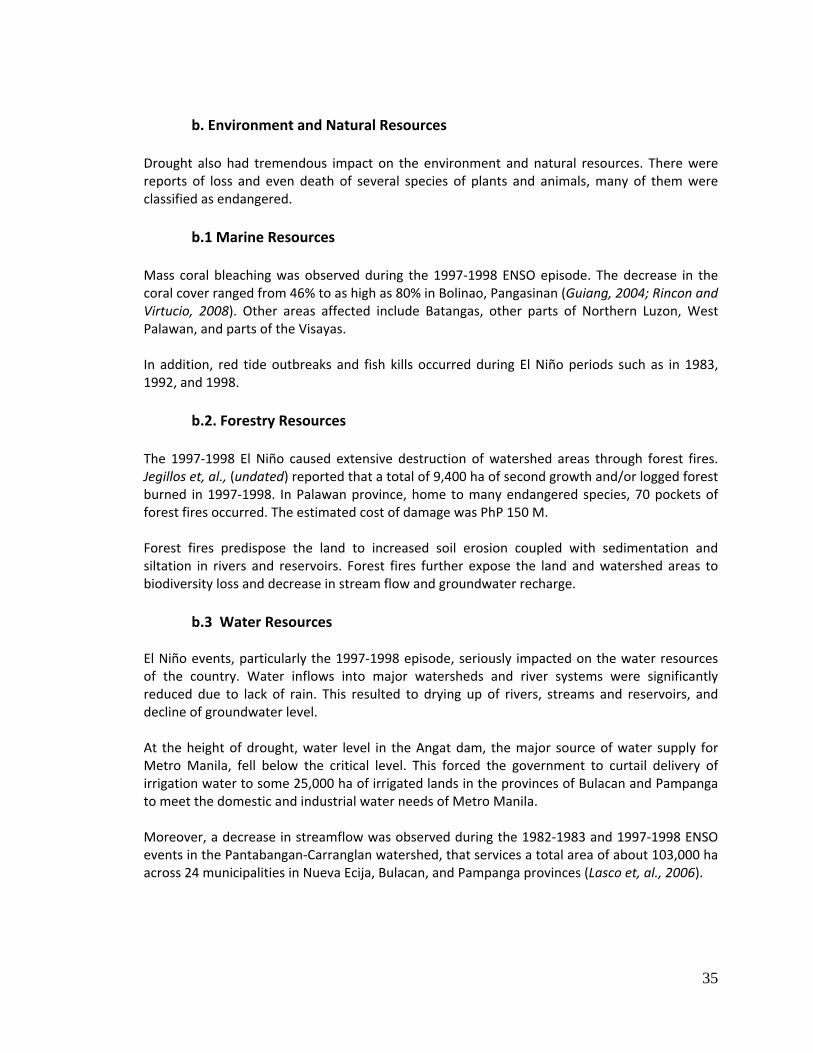
b. Environment and Natural Resources
Drought also had tremendous impact on the environment and natural resources. There were reports of loss and even death of several species of plants and animals, many of them were classified as endangered.
b.1 Marine Resources
Mass coral bleaching was observed during the 1997‐1998 ENSO episode. The decrease in the coral cover ranged from 46% to as high as 80% in Bolinao, Pangasinan (Guiang, 2004; Rincon and Virtucio, 2008). Other areas affected include Batangas, other parts of Northern Luzon, West Palawan, and parts of the Visayas.
In addition, red tide outbreaks and fish kills occurred during El Niño periods such as in 1983, 1992, and 1998.
b.2. Forestry Resources
The 1997‐1998 El Niño caused extensive destruction of watershed areas through forest fires. Jegillos et, al., (undated) reported that a total of 9,400 ha of second growth and/or logged forest burned in 1997‐1998. In Palawan province, home to many endangered species, 70 pockets of forest fires occurred. The estimated cost of damage was PhP 150 M.
Forest fires predispose the land to increased soil erosion coupled with sedimentation and siltation in rivers and reservoirs. Forest fires further expose the land and watershed areas to biodiversity loss and decrease in stream flow and groundwater recharge.
b.3 Water Resources
El Niño events, particularly the 1997‐1998 episode, seriously impacted on the water resources of the country. Water inflows into major watersheds and river systems were significantly reduced due to lack of rain. This resulted to drying up of rivers, streams and reservoirs, and decline of groundwater level.
At the height of drought, water level in the Angat dam, the major source of water supply for Metro Manila, fell below the critical level. This forced the government to curtail delivery of irrigation water to some 25,000 ha of irrigated lands in the provinces of Bulacan and Pampanga to meet the domestic and industrial water needs of Metro Manila.
Moreover, a decrease in streamflow was observed during the 1982‐1983 and 1997‐1998 ENSO events in the Pantabangan‐Carranglan watershed, that services a total area of about 103,000 ha across 24 municipalities in Nueva Ecija, Bulacan, and Pampanga provinces (Lasco et, al., 2006).
36
3.1.2.2 Water Resources Distribution, Use and Quality
The critical role of water in mitigating the adverse effects of droughts and in combating land degradation and desertification is recognized. Proper management of water resources is a key factor in ensuring sustained supply of freshwater especially in prolonged‐dry spell periods.
World Bank (2003) reported that agriculture accounts for 85.27% of the available water while the remaining 15% is shared by the domestic (7.27%) and industrial (7.46%) sectors.
1) Surface water
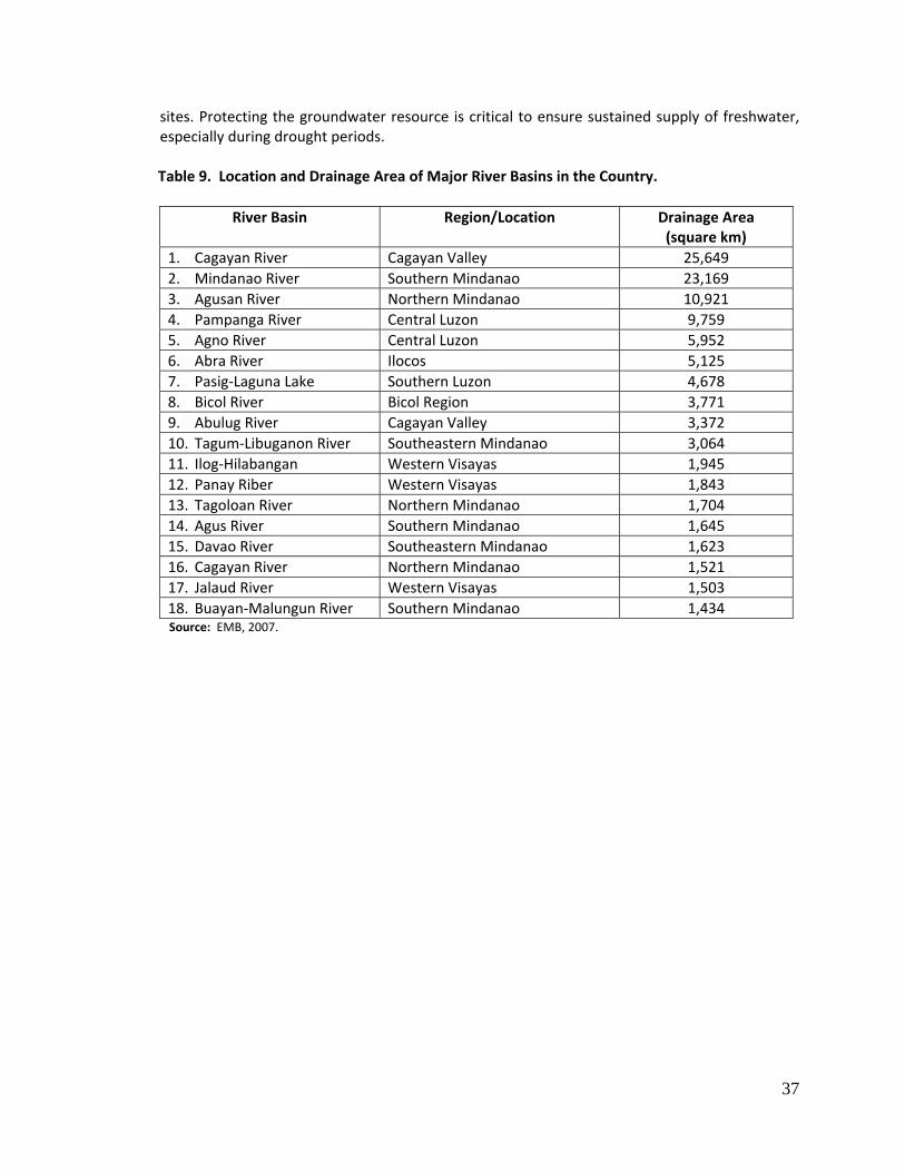
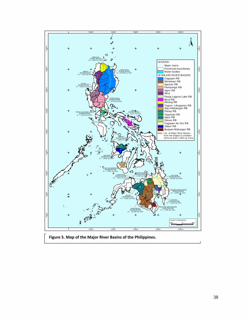
The country is endowed with 421 river basins in 119 proclaimed watershed areas (WB, 2003; EMB, 2007). Of these, 20 are considered major river basins with each one having at least 990 square km basin area (Table 9); 8 are located in Mindanao, 7 in Luzon, and only 3 in the Visayas (Figure 9). However, only 36% are classified possible sources of water supply (WB, 2003). The most recent data from EMB (2007) showed that, of the 611 classified inland water bodies, only 208 or about 34% are suitable for water supply. Out of the five Class AA (requiring only minimal disinfection) rivers, two are located in Davao (seasonally‐arid and severely eroded area), one in Cebu (drought‐prone province), and two are in the Cordillera Administrative Region (CAR) which is severely eroded and has the highest concentration of indigenous peoples (IPs).
As of 2005, the National Water Resources Board (NWRB) has granted 9,711 abstraction permits; 91% was for agricultural purposes (irrigation and fisheries), 4% was for domestic use, and the remaining 4% was divided for industrial, commercial, and recreational purposes. By regional distribution, drought‐prone areas of Regions II, III, IV and X had the highest abstraction rates. Interventions to prevent over‐exploitation of these critical watershed and river systems are vital.
2) Groundwater
There is an approximately 50,000 square km of groundwater reservoir (EMB, 2007) and contributes about 14% of the total water resource potential of the country (WB, 2003). Regions I and VII have the highest potential while Region X has the lowest.
In contrast, NWRB reported that as of 2005, the biggest consumer of groundwater was the domestic sector at 49% and followed by the agriculture sector (39%). The industrial and other sectors accounted for 10% and 4%, respectively. Regions IV and III had the highest abstraction rate with 21% and 16%, respectively. However, unregulated abstraction, which account for about 60% and indiscriminate withdrawal resulted to groundwater level decline (i.e., Cebu) and in some areas, seawater intrusion in coastal aquifers (WB, 2003). Saltwater intrusion was reported to be evident in nearly 28% of coastal municipalities in Luzon, 20% in the Visayas, and 29% in Mindanao (Rellin et al., 1999 as cited in Perez, 2002). Aside from over exploitation, pollution and contamination due to improper disposal of household, industrial and agricultural wastes further threaten the country’s groundwater resource. For instance, about 50% of the wells monitored by the Environmental Management Bureau (EMB,2007) in 2005 were found contaminated with fecal coliforms. Regions II and Region VI (seasonally‐arid and drought‐prone areas) have the most number of contaminated
37
sites. Protecting the groundwater resource is critical to ensure sustained supply of freshwater, especially during drought periods.
Table 9. Location and Drainage Area of Major River Basins in the Country.
River Basin Region/Location Drainage Area (square km)
1. Cagayan River Cagayan Valley 25,649 2. Mindanao River Southern Mindanao 23,169 3. Agusan River Northern Mindanao 10,921 4. Pampanga River Central Luzon 9,759 5. Agno River Central Luzon 5,952 6. Abra River Ilocos 5,125 7. Pasig‐Laguna Lake Southern Luzon 4,678 8. Bicol River Bicol Region 3,771 9. Abulug River Cagayan Valley 3,372 10. Tagum‐Libuganon River Southeastern Mindanao 3,064 11. Ilog‐Hilabangan Western Visayas 1,945 12. Panay Riber Western Visayas 1,843 13. Tagoloan River Northern Mindanao 1,704 14. Agus River Southern Mindanao 1,645 15. Davao River Southeastern Mindanao 1,623 16. Cagayan River Northern Mindanao 1,521 17. Jalaud River Western Visayas 1,503 18. Buayan‐Malungun River Southern Mindanao 1,434
Source: EMB, 2007.
38
RO SA R IO
GM A
GE NE R ALEM IL IOAG UI NA LD O
CA RM O NA
GE N. TR IA S
MA RA G ON D ON
MEN DE
Z-
NUÑ E
Z
TA GA Y TA Y
C IT Y
PRO V
I NCE O
F BA T
A NGAS
PR
OVIN
C E O
F LA
GUN
A
LAS PI ÑA
S
(N CR
)
NO VE L ET A
CAGAYANRIVER BASIN
A = 25,469 sq. kms.
ABULUGRIVER BASIN
A = 3,362 sq. kms.
ABRARIVER BASIN
A = 5,125 sq. kms.
AGNORIVER BASIN
A = 5,952 sq. kms.
PAMPANGARIVER BASIN
A = 9,753 sq. kms.
PASIG-LAGUNA LAKERIVER BASIN
A = 4,678 sq. kms.
BICOLRIVER BASIN
A = 3,771 sq. kms.
PANAYRIVER BASIN
A = 1,843 sq. kms.
JALAURRIVER BASIN
A = 1,503 sq. kms.
ILOG-HILABANGANRIVER BASIN
A = 1,945 sq. kms.
AGUSANRIVER BASIN
A = 10,921 sq. kms.
TAGUM-LIBUGANONRIVER BASIN
A = 3,064 sq. kms.
DAVAORIVER BASIN
A = 1,623 sq. kms.
BUAYAN-MALUNGANRIVER BASIN
A = 1,435 sq. kms.MINDANAO
RIVER BASINA = 23,169 sq. kms.
AGUSRIVER BASIN
A = 1,645 sq. kms.
CAGAYANRIVER BASIN
A = 1,521 sq. kms.
TAGOLOANRIVER BASIN
A = 1,704 sq. kms.
0
0
200000
200000
400000
400000
600000
600000
800000
800000
1000000
1000000
6000
00600000
8000
00800000
1000
000 1000000
1200
000 1200000
1400
000 1400000
1600
000 1600000
1800
000 1800000
2000
000 2000000
2200
000 2200000
N
Water bodies
Abulug RB
AbraAgno RB
Agus RB
Agusan RB
Bicol RB
Buayan-Malungan RB
Cagayan RB
Cagayan de Oro RBDavao RB
Ilog-Hilabangan RB
Jalaur RB
Mindanao RB
Pampanga RB
Panay RB
Pasig-Laguna Lake RB
Tagum -Libuganon RB
Tagoloan RB
Provincial boundaries
LEGEND:
18 MAJOR RIVER BASINS
Major rivers
100 0 100Scale in Kilometers
Note: List of Major River Basins from the largest to smallest (Area at least 1,400 sq. kms).
Figure 5. Map of the Major River Basins of the Philippines.
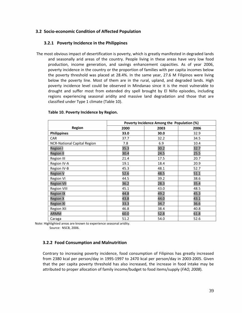
39
3.2 Socio‐economic Condition of Affected Population 3.2.1 Poverty Incidence in the Philippines
The most obvious impact of desertification is poverty, which is greatly manifested in degraded lands
and seasonally arid areas of the country. People living in these areas have very low food production, income generation, and savings enhancement capacities. As of year 2006, poverty incidence in the country or the proportion of families with per capita incomes below the poverty threshold was placed at 28.4%. In the same year, 27.6 M Filipinos were living below the poverty line. Most of them are in the rural, upland, and degraded lands. High poverty incidence level could be observed in Mindanao since it is the most vulnerable to drought and suffer most from extended dry spell brought by El Niño episodes, including regions experiencing seasonal aridity and massive land degradation and those that are classified under Type 1 climate (Table 10).
Table 10. Poverty Incidence by Region.
Region
Poverty Incidence Among the Population (%)2000 2003 2006
Philippines 33.0 30.0 32.9CAR 37.7 32.2 34.5NCR‐National Capital Region 7.8 6.9 10.4Region I 35.3 30.2 32.7Region II 30.4 24.5 25.5Region III 21.4 17.5 20.7Region IV‐A 19.1 18.4 20.9Region IV‐B 45.3 48.1 52.7Region V 52.6 48.5 51.1Region VI 44.5 39.2 38.6Region VII 36.2 28.3 35.4Region VIII 45.1 43.0 48.5Region IX 44.8 49.2 45.3Region X 43.8 44.0 43.1Region XI 33.3 34.7 36.6Region XII 46.8 38.4 40.8ARMM 60.0 52.8 61.8Caraga 51.2 54.0 52.6
Note: Highlighted areas are known to experience seasonal aridity. Source: NSCB, 2006.
3.2.2 Food Consumption and Malnutrition Contrary to increasing poverty incidence, food consumption of Filipinos has greatly increased from 2380 kcal per person/day in 1995‐1997 to 2470 kcal per person/day in 2003‐2005. Given that the per capita poverty threshold has also increased, the increase in food intake may be attributed to proper allocation of family income/budget to food items/supply (FAO, 2008).
40
Malnutrition, which also means undernourishment in the Philippines, is caused by a lot of inter‐related factors such as health, physical, social, and economic. Improper distribution of food supply and its consumption has a detrimental impact on nutritional status. Even though reports claim that there is/are sufficient food supply to sustain the country, a large portion of the population become undernourished due to insufficient food and nutrient intake. Given the economic situation of the country, and having a high poverty incidence rate of 32.9%, undernourishment is expected to be a problem such that about 27.6 M Filipinos may find it difficult to meet their food and nutritional requirements and other basic necessities. Notwithstanding the reports suggesting that the prevalence of undernourishment has diminished from 18% (1995‐1997) to 16% by 2005 (FAO, 2008), it is still a big issue that must be dealt with vigilance. This is also considering that about 27% or over 3 M 0–5 year‐old children were underweight‐for‐age. Only 72% of the children population had normal nutritional status based on weight for age (National Nutrition Statistics, 2003).
3.2.3 Access to Water Supply Services In terms of water supply services, the National Economic Development Authority (NEDA 2009) reported that according to the World Health Organization (WHO) and the United Nations Children’s Fund (UNICEF), overall access declined to 85% in 2002 from 87% in 1990. NEDA (2009) further reported that based on the 2000 data compiled by the Department of Interior and Local Government (DILG) in 2007, only 9 M Filipinos are being served by water providers (either LGU‐run, private, and NGOs). This implies that majority and most likely those in the rural areas rely on alternative water sources through pump and engine or open dug well and fetching from rivers/spring systems.
3.3 Policy and Legislative Efforts to Address Desertification, Land Degradation and
Drought Issues Relevant legislations have been reviewed in order to address underlying factors and crucial issues relevant to combating land degradation and mitigating the effects of drought in the Philippines. These legislations include the following and brief discussion on the content of related legislations as indicated in Annex 3: • Agriculture and Fisheries Modernization Act or Republic Act 8435; • The Local Government Code of 1991, Republic Act 7160; • National Integrated Protected Areas System (NIPAS) or Republic Act 7586; • Comprehensive Agrarian Reform Law or Republic Act 6657; • CARPer Law or Republic Act 9700; • Indigenous Peoples’ Rights Act or Republic Act 8371; • Department of Energy Act or Republic Act 7638; • Special Economic Zone Act or Republic Act 7916; • Urban Development and Housing Act or Republic Act 7279; • Climate Change Act of 2009 or Republic Act 9729; • Revised Forestry Code of the Philippines or Presidential Decree 705; • The Environmental Impact Assessment System or Presidential Decree 1586;
41
• The Balanced Fertilization Strategy (BFS), Presidential Proclamation 1071; • Water Code of the Philippines; • Clean Water Act of the Philippines; • Medium‐Term Philippine Development Plan (MTPDP) 2004‐2010; • National Land Use Bill; • Office of the President Administrative Order 226 as amended by 226‐A series of 2008 on
suspending the processing and approval of all land conversion applications of all rice lands; • Executive Order 807 Series of 2009 repealing Letter of Instruction (LOI) No. 58 of 1973; • Executive Order 774 Series of 2008 on Reorganizing the Presidential Task Force on Climate
Change; • Executive Order 481 Series of 2005 on Promotion and Development of Organic Agriculture in
the Philippines; • National Program for Sustainable Upland Farming through the establishment of “Barangay
Sagip Saka” (Conservation Farming Village); • Senate Bill 3038: Private Land Forestry and Incentive Act of 1999; • Senate Bill 3131: Water Use Efficiency and Conservation Research Act of 2009; • Senate Bill 3296: Waterless Technology Act of 2009; • Senate Bill 3264: Organic Agriculture Act of 2009; • Integrated Water Resources Management; • Irrigation Management Transfer; • National Water Resources Policy; • Raw Water Pricing (Pilot Stage); and • Participatory Irrigation Development Project (PIDP) (recently ICC approved project).
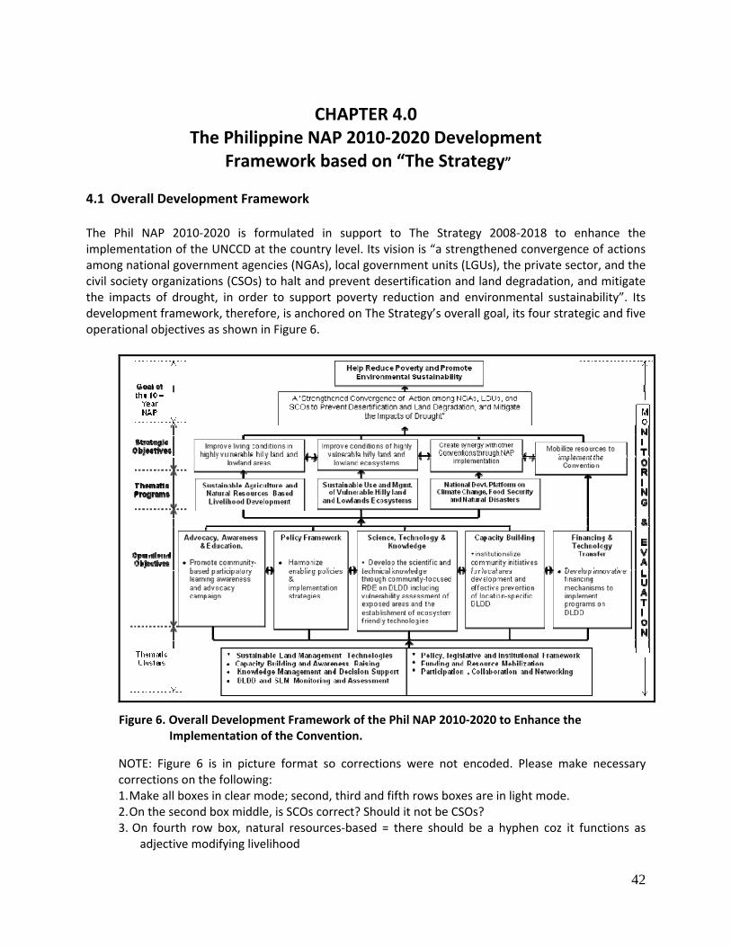
42
CHAPTER 4.0 The Philippine NAP 2010‐2020 Development
Framework based on “The Strategy”
4.1 Overall Development Framework
The Phil NAP 2010‐2020 is formulated in support to The Strategy 2008‐2018 to enhance the implementation of the UNCCD at the country level. Its vision is “a strengthened convergence of actions among national government agencies (NGAs), local government units (LGUs), the private sector, and the civil society organizations (CSOs) to halt and prevent desertification and land degradation, and mitigate the impacts of drought, in order to support poverty reduction and environmental sustainability”. Its development framework, therefore, is anchored on The Strategy’s overall goal, its four strategic and five operational objectives as shown in Figure 6.
NOTE: Figure 6 is in picture format so corrections were not encoded. Please make necessary corrections on the following: 1. Make all boxes in clear mode; second, third and fifth rows boxes are in light mode. 2. On the second box middle, is SCOs correct? Should it not be CSOs? 3. On fourth row box, natural resources‐based = there should be a hyphen coz it functions as
adjective modifying livelihood
Figure 6. Overall Development Framework of the Phil NAP 2010‐2020 to Enhance the Implementation of the Convention.
43
4. On the fifth row, box on Capability building, capitalize I in Institutionalize 5. On fourth row, second box, short of Management is Mgt 6. Last row of boxes, on the right, please make format consistent with the rest as caps and lower
case. Capitalize L in legislative and I in institutional; and move comma right after n of Participation
The Overall Development Framework of the Phil NAP 2010‐2020, therefore, consists of a sound National Development Strategy (NDS) that highlights long‐term (Strategic Plan) and short‐ to medium‐term (Operational Plan) policies and programs to prevent desertification and land degradation, and mitigate impacts of drought. Long–term Strategic Plan is expressed in terms of three Major Thematic Programs, namely:
1. Sustainable Agriculture and Natural Resources Based Livelihood Development – to provide livelihoods in rural areas and improve their resilience to land degradation and climate change;
2. Sustainable Use and Management of Ecosystems – to prevent depletion and degradation of natural resources and protect biodiversity through practices that consider these resources as interdependent ecosystems; and
3. UNCCD as a National Adaptation Platform “To Address Climate Change and Food Security, and Improve Resilience to Natural Disasters” – to contribute to the global efforts to reduce poverty, protect human lives, and ensure environmental sustainability through the development of synergy with other Conventions.
On the other hand, short‐ to medium‐term Operational Plan is expressed in seven Thematic Clusters to address the five operational objectives of the Convention at the country level. As indicated in Figure 4‐1, these clusters consist of:
1. Sustainable Land Management Technologies (including Adaptation); 2. Capacity Building and Awareness Raising; 3. Knowledge Management and Decision Support; 4. DLDD and SLM Monitoring and Assessment; 5. Policy, Legislative, and Institutional Framework; 6. Funding and Resource Mobilization; and 7. Participation, Collaboration and Networking.
An effective monitoring and assessment strategy will be in place to evaluate the progress of achieving the strategic objectives (through impact indicators) and operational objectives (through performance indicators). The Phil NAP 2010‐2020 adheres with the recommended minimum set of impact indicators set by the Convention that includes: Strategic Objective 1‐ Improve the living conditions in highly vulnerable hilly lands and lowland
areas.
1. Water availability per capita in affected areas; 2. Percentage of population in affected areas living above poverty line; and
44
3. Childhood malnutrition and/or food consumption/caloric intake per capita in affected areas
Strategic Objective 2‐ Improve the conditions of hilly lands and lowland ecosystems
1. Changes in land use; 2. Level of land degradation (including salinization, water and wind erosion, etc.); 3. Plant and animal biodiversity; and 4. Water use efficiency/Aridity index.
Strategic Objective 3 – To generate global benefits through effective implementation of the
UNCCD
1. Plant and animal biodiversity 2. Carbon stocks above and below ground 3. Lands under Sustainable Land Management (SLM)
The progress of implementation of the Philippine NAP 2010‐2020 will be assessed in terms of the attainment of major final outputs from the different programs and projects under it.
4.2 Characters of the Philippine NAP 2010‐2020
The Phil NAP 2010 ‐ 2020 is a land and water‐centered action plan that focuses on the creation of livelihoods to affected population, sustainable use and management of affected ecosystems and the formulation of a national adaptation platform to address climate change, food security, and improve the country’s resilience to natural disasters.
Its geographical domain and priority landscapes are DLDD vulnerable areas in: 1. Hillyland and upland ecosystems in which climatic drivers and human‐induced activities result to
land degradation and loss of biodiversity; and 2. Lowland ecosystems which experience seasonal aridity and drought that could result to low
productivity and reduced farm income.
The Phil NAP 2010 ‐2020 emphasizes the need for synergy among the environmental Conventions at the country level (Figure 7) and the Convergence of Actions among national government agencies (NGAs), local government units (LGUs), the private sector, and civil society organizations (CSOs) to contribute to poverty reduction and ensure environmental sustainability.
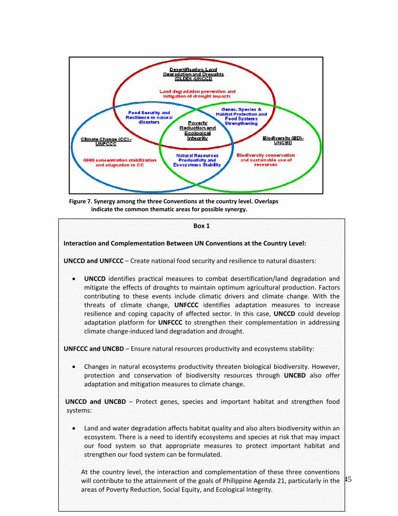
45
Figure 7. Synergy among the three Conventions at the country level. Overlaps indicate the common thematic areas for possible synergy.
Box 1
Interaction and Complementation Between UN Conventions at the Country Level: UNCCD and UNFCCC – Create national food security and resilience to natural disasters:
• UNCCD identifies practical measures to combat desertification/land degradation and mitigate the effects of droughts to maintain optimum agricultural production. Factors contributing to these events include climatic drivers and climate change. With the threats of climate change, UNFCCC identifies adaptation measures to increase resilience and coping capacity of affected sector. In this case, UNCCD could develop adaptation platform for UNFCCC to strengthen their complementation in addressing climate change‐induced land degradation and drought.
UNFCCC and UNCBD – Ensure natural resources productivity and ecosystems stability:
• Changes in natural ecosystems productivity threaten biological biodiversity. However, protection and conservation of biodiversity resources through UNCBD also offer adaptation and mitigation measures to climate change.
UNCCD and UNCBD – Protect genes, species and important habitat and strengthen food systems:
• Land and water degradation affects habitat quality and also alters biodiversity within an ecosystem. There is a need to identify ecosystems and species at risk that may impact our food system so that appropriate measures to protect important habitat and strengthen our food system can be formulated.
At the country level, the interaction and complementation of these three conventions will contribute to the attainment of the goals of Philippine Agenda 21, particularly in the areas of Poverty Reduction, Social Equity, and Ecological Integrity.
46
4.3 Goals and Objectives
Consistent with the scope of the Convention, The Strategy and its Objectives, the Phil NAP 2010‐2020 has the following goal and objectives:
Goal To support and contribute to the national efforts on poverty reduction and ensuring environmental sustainability. Specific Objectives 1. To promote community‐based participatory learning and awareness campaign on the threats
and impacts of DLDD and create advocacy among policy and decision makers to address the problems;
2. To harmonize enabling policies and implementation strategies to contribute in the formulation of new laws and/or effective implementations of existing laws relating to DLDD;
3. To develop the scientific and technical knowledge of concerned institutions through community‐focused research, development and extension (RDE) on DLDD, including vulnerability assessment of exposed areas and the establishment of ecosystem friendly technologies;
4. To institutionalize community initiatives for local area development and effective prevention of
location‐specific desertification, land degradation and mitigation of effects of droughts; and
5. To formulate and develop more innovative financing mechanisms to implement the programs to combat desertification/land degradation and mitigate the effects of droughts.
The attainment of these objectives will be monitored and assessed in terms of operational performance of relevant projects implemented for each thematic cluster. Long‐term impacts will be based on the minimum set of impact indicators set to monitor progress of the attainment of strategic objectives of UNCCD at the country level. 4.4 Priority Programs and Projects by Thematic Cluster
The priority programs and projects under the Phil NAP 2010‐2020 (Table 11) are classified according to the seven thematic clusters to address the operational objectives of the action plan. Best practices, success stories and lessons learned from the implementation of the various programs and projects can be obtained through these clusters from which the performance and contribution of the Philippines as one of the Country Parties to UNCCD can be assessed during the national reporting period every four years.
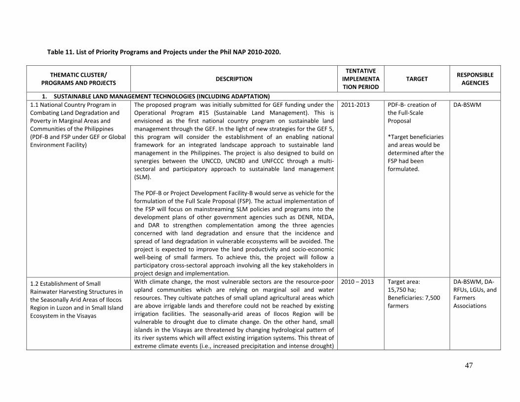
47
Table 11. List of Priority Programs and Projects under the Phil NAP 2010‐2020.
THEMATIC CLUSTER/ PROGRAMS AND PROJECTS
DESCRIPTION TENTATIVE
IMPLEMENTATION PERIOD
TARGET RESPONSIBLE AGENCIES
1. SUSTAINABLE LAND MANAGEMENT TECHNOLOGIES (INCLUDING ADAPTATION) 1.1 National Country Program in Combating Land Degradation and Poverty in Marginal Areas and Communities of the Philippines (PDF‐B and FSP under GEF or Global Environment Facility)
The proposed program was initially submitted for GEF funding under the Operational Program #15 (Sustainable Land Management). This is envisioned as the first national country program on sustainable land management through the GEF. In the light of new strategies for the GEF 5, this program will consider the establishment of an enabling national framework for an integrated landscape approach to sustainable land management in the Philippines. The project is also designed to build on synergies between the UNCCD, UNCBD and UNFCCC through a multi‐sectoral and participatory approach to sustainable land management (SLM). The PDF‐B or Project Development Facility‐B would serve as vehicle for the formulation of the Full Scale Proposal (FSP). The actual implementation of the FSP will focus on mainstreaming SLM policies and programs into the development plans of other government agencies such as DENR, NEDA, and DAR to strengthen complementation among the three agencies concerned with land degradation and ensure that the incidence and spread of land degradation in vulnerable ecosystems will be avoided. The project is expected to improve the land productivity and socio‐economic well‐being of small farmers. To achieve this, the project will follow a participatory cross‐sectoral approach involving all the key stakeholders in project design and implementation.
2011‐2013 PDF‐B‐ creation of the Full‐Scale Proposal *Target beneficiaries and areas would be determined after the FSP had been formulated.
DA‐BSWM
1.2 Establishment of Small Rainwater Harvesting Structures in the Seasonally Arid Areas of Ilocos Region in Luzon and in Small Island Ecosystem in the Visayas
With climate change, the most vulnerable sectors are the resource‐poor upland communities which are relying on marginal soil and water resources. They cultivate patches of small upland agricultural areas which are above irrigable lands and therefore could not be reached by existing irrigation facilities. The seasonally‐arid areas of Ilocos Region will be vulnerable to drought due to climate change. On the other hand, small islands in the Visayas are threatened by changing hydrological pattern of its river systems which will affect existing irrigation systems. This threat of extreme climate events (i.e., increased precipitation and intense drought)
2010 – 2013 Target area: 15,750 ha; Beneficiaries: 7,500 farmers
DA‐BSWM, DA‐RFUs, LGUs, and Farmers Associations
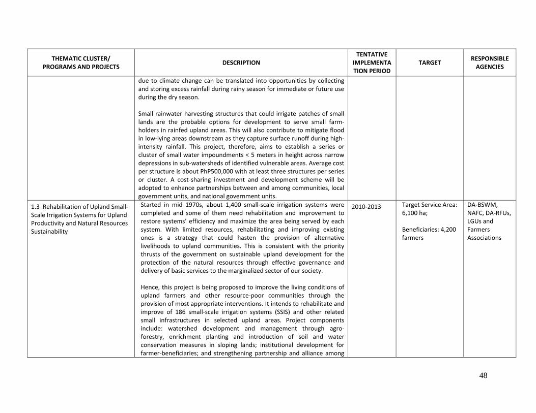
48
THEMATIC CLUSTER/ PROGRAMS AND PROJECTS
DESCRIPTION TENTATIVE
IMPLEMENTATION PERIOD
TARGET RESPONSIBLE AGENCIES
due to climate change can be translated into opportunities by collecting and storing excess rainfall during rainy season for immediate or future use during the dry season. Small rainwater harvesting structures that could irrigate patches of small lands are the probable options for development to serve small farm‐holders in rainfed upland areas. This will also contribute to mitigate flood in low‐lying areas downstream as they capture surface runoff during high‐intensity rainfall. This project, therefore, aims to establish a series or cluster of small water impoundments < 5 meters in height across narrow depressions in sub‐watersheds of identified vulnerable areas. Average cost per structure is about PhP500,000 with at least three structures per series or cluster. A cost‐sharing investment and development scheme will be adopted to enhance partnerships between and among communities, local government units, and national government units.
1.3 Rehabilitation of Upland Small‐Scale Irrigation Systems for Upland Productivity and Natural Resources Sustainability
Started in mid 1970s, about 1,400 small‐scale irrigation systems were completed and some of them need rehabilitation and improvement to restore systems’ efficiency and maximize the area being served by each system. With limited resources, rehabilitating and improving existing ones is a strategy that could hasten the provision of alternative livelihoods to upland communities. This is consistent with the priority thrusts of the government on sustainable upland development for the protection of the natural resources through effective governance and delivery of basic services to the marginalized sector of our society. Hence, this project is being proposed to improve the living conditions of upland farmers and other resource‐poor communities through the provision of most appropriate interventions. It intends to rehabilitate and improve of 186 small‐scale irrigation systems (SSIS) and other related small infrastructures in selected upland areas. Project components include: watershed development and management through agro‐forestry, enrichment planting and introduction of soil and water conservation measures in sloping lands; institutional development for farmer‐beneficiaries; and strengthening partnership and alliance among
2010‐2013 Target Service Area:6,100 ha; Beneficiaries: 4,200 farmers
DA‐BSWM, NAFC, DA‐RFUs, LGUs and Farmers Associations
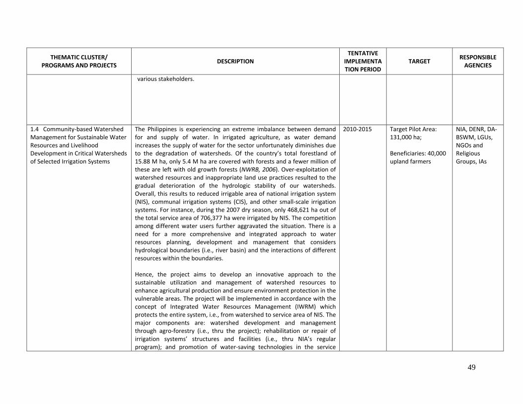
49
THEMATIC CLUSTER/ PROGRAMS AND PROJECTS
DESCRIPTION TENTATIVE
IMPLEMENTATION PERIOD
TARGET RESPONSIBLE AGENCIES
various stakeholders.
1.4 Community‐based Watershed Management for Sustainable Water Resources and Livelihood Development in Critical Watersheds of Selected Irrigation Systems
The Philippines is experiencing an extreme imbalance between demand for and supply of water. In irrigated agriculture, as water demand increases the supply of water for the sector unfortunately diminishes due to the degradation of watersheds. Of the country’s total forestland of 15.88 M ha, only 5.4 M ha are covered with forests and a fewer million of these are left with old growth forests (NWRB, 2006). Over‐exploitation of watershed resources and inappropriate land use practices resulted to the gradual deterioration of the hydrologic stability of our watersheds. Overall, this results to reduced irrigable area of national irrigation system (NIS), communal irrigation systems (CIS), and other small‐scale irrigation systems. For instance, during the 2007 dry season, only 468,621 ha out of the total service area of 706,377 ha were irrigated by NIS. The competition among different water users further aggravated the situation. There is a need for a more comprehensive and integrated approach to water resources planning, development and management that considers hydrological boundaries (i.e., river basin) and the interactions of different resources within the boundaries. Hence, the project aims to develop an innovative approach to the sustainable utilization and management of watershed resources to enhance agricultural production and ensure environment protection in the vulnerable areas. The project will be implemented in accordance with the concept of Integrated Water Resources Management (IWRM) which protects the entire system, i.e., from watershed to service area of NIS. The major components are: watershed development and management through agro‐forestry (i.e., thru the project); rehabilitation or repair of irrigation systems’ structures and facilities (i.e., thru NIA’s regular program); and promotion of water‐saving technologies in the service
2010‐2015 Target Pilot Area:131,000 ha; Beneficiaries: 40,000 upland farmers
NIA, DENR, DA‐BSWM, LGUs, NGOs and Religious Groups, IAs
50
THEMATIC CLUSTER/ PROGRAMS AND PROJECTS
DESCRIPTION TENTATIVE
IMPLEMENTATION PERIOD
TARGET RESPONSIBLE AGENCIES
areas. 1.5 Establishment of Agro‐meteorological Stations in Highly Vulnerable Agricultural Areas: A tool for Climate Change Adaptation and Development of Local Early Warning System
Most of the natural disasters that hit the country for the last three decades that severely affected the agriculture sector were due to hydro‐meteorological phenomena. With the threat of climate change, the situation maybe aggravated by extreme climate events. As the agriculture sector formulates climate change adaptation strategies, it also needs tools that could provide real‐time and more localized agro‐meteorological information to help farmers in decision‐making and solving field operation problems. The current situation therefore necessitates more localized and accurate agro‐meteorological information that could be applied in a temporal and spatial context. Agro‐meteorological data and information are important in identifying suitable crops and in crop planning to optimize agricultural production. These data are likewise critical in water resources management especially in developing areas for water storage and in the design of structures for irrigation, domestic water supply, and other agricultural uses. However, there are only few operational agro‐meteorological stations and most of their instruments need repair/replacement to ensure accurate and reliable data. There is a need, therefore, for new and state‐of‐the‐art agro‐meteorological instruments that will be installed in strategic areas (i.e., upland areas and critical watersheds) to serve as tools for crop planning and as early warning devices. In addition, local people should also be empowered to operate and maintain agro‐meteorological stations and enhance their knowledge and skills on crop planning and disaster management. Thus, this project proposes to strengthen the existing agro‐meteorological stations of BSWM by establishing 126 automatic weather stations in selected upland agricultural areas and critical watersheds in 78 provinces. It also aims to capacitate upland communities to operate and maintain these facilities and to effectively utilize climate information in their farming activities through climate field school (CFS). The project will be implemented in partnership with concerned LGUs with support and
2010‐2014 DA‐BSWM, DA‐RFUs, NAFC, DOST‐PAGASA, LGUs, Local Upland Communities
51
THEMATIC CLUSTER/ PROGRAMS AND PROJECTS
DESCRIPTION TENTATIVE
IMPLEMENTATION PERIOD
TARGET RESPONSIBLE AGENCIES
assistance from PAGASA.
1.6 Promotion of Farm Wastes Re‐cycling and Re‐use for Organic‐based Agriculture Development in Vulnerable Upland and Lowland Areas
In most lowland and upland farms, low crop production accelerates the heavy usage of chemical inputs and fertilizers become an indispensable input in farming operations for so many years. The continuous application of synthetic fertilizers to solve massive nutrient depletion exacerbates the problem that resulted to the continuing cycle of land degradation and desertification. Moreover, the increased amount and cost of inorganic fertilizers being applied result to a parallel increase in production cost, thus reducing farm income. Lands that were once productive are now less suitable for agricultural production, thus worsening the problem of meeting the food requirements of increasing population in the urban areas. Poor plant growth result in poor groundcover and render the exposed soil surface to soil erosion and removal of soil organic matter. This situation is the primary cause of the rapid decline of upland crop production and the abandonment of many farms by marginal farmers. Yet, there are available resources and technologies that could be harnessed within a farm to address the problem. Farm wastes can be transformed into viable resources by re‐cycling and re‐using them as organic fertilizers through various composting technologies instead of disposing them to the environment that may contribute to the emission of greenhouse gases into the atmosphere or to the deterioration of quality of receiving water bodies. Hence, this project aims to maximize the utilization of farm wastes and residues in support to organic‐based agriculture development through various acceptable composting technologies. Project components include provision of composting facilities to selected farmers group, technology demonstration, and farmers’ training/capacity building.
2009‐2011 Target Area: 260,000 ha
DA‐BSWM, DA‐RFUs, DA‐ATI, LGUs and NGOs,
1.7 Promotion of Water‐ Saving Technologies (WST) in Irrigated Rice Production System
Freshwater is becoming scarce to support agricultural production. With over‐exploitation, water pollution, and increasing competition among water users, sustainable water management becomes a priority for action in the agriculture sector. This is also recognizing that agriculture is the biggest water user taking 80% of the total freshwater withdrawal of which
2009‐2013 PhilRice, NIA, DA‐BSWM, LGUs and IAs
52
THEMATIC CLUSTER/ PROGRAMS AND PROJECTS
DESCRIPTION TENTATIVE
IMPLEMENTATION PERIOD
TARGET RESPONSIBLE AGENCIES
more than 50% is from irrigation of rice production system. Yet, current practice in rice cultivation is so wasteful with irrigation utilization ranging from 3,000 to 5,000 liters of water to produce 1 kg of rice. As the country aims for 100% rice self sufficiency by 2013, there is a need to promote water‐saving technologies (WSTs) to ensure that such target could be achieved without affecting the requirement of other water users. There are available WSTs that could be adopted from land preparation modification and direct seeding techniques to water application modification such as alternate wetting and drying (AWD) or controlled irrigation. Recent research results showed that AWD could save 15% to 35% of irrigation water without yield reduction. The Philippine Rice Self Sufficiency Plan (RSSP) specifies the need for judicious use of water resources in support to the attainment of 100% sufficiency level in rice by 2013. Hence, this project intends to promote the implementation and adoption AWD and other sound WST to facilitate expansion of irrigated areas with lesser investments for the establishment of new systems. The project will specifically cover vulnerable irrigated rice production areas.
2. CAPACITY BUILDING AND AWARENESS RAISING 2.1 Support to the Development and Publication of DLDD and SLM Knowledge Products and Tri‐media Materials
Several technologies could be generated from the implementation of Research and Development and Extension (RD & E) component of the Phil NAP. Hence, these technologies should be disseminated to food‐insecure and degraded lands in the lowland and hilly pedo‐ecological zones, particularly those within the agrarian reform communities (ARC) in order to equip them with adequate knowledge and skills to conduct sustainable management strategies. One of the most effective ways to provide advisory and disseminate information on the character, impact and appropriate measures to mitigate the effects of drought, land degradation and seasonal aridity is through the use of tri‐media. Publication in locally understood dialect to communicate the knowledge products on SLM and DLDD would enhance access of target groups to vital information on DLDD and thus help them to cope and adopt appropriate technologies.
2010‐2016 DA‐ATI and BSWM, DENR, DAR, DOST
2.2 Establishment of Network of Model Farms, Farmer‐Experts and
From a pool of outstanding farmers searched over the years annually through the DA’s `Gawad Saka Award’, a network of model farms can be
2010‐2016 DA‐ATI and BSWM; DAR;
53
THEMATIC CLUSTER/ PROGRAMS AND PROJECTS
DESCRIPTION TENTATIVE
IMPLEMENTATION PERIOD
TARGET RESPONSIBLE AGENCIES
Farmers’ Participatory Learning Center (FPLC) for the Promotion of Best Farming Practices on Sustainable Agriculture and Natural Resources Management and for Technology Adaptation and Development of Understanding Desertification. Biodiversity and Climate Change
established to promote and advocate best farming practices towards sustainable agriculture and natural resources management. Awardees could be effective conduits in communicating their success stories to fellow farmers and become part of the network of farmer‐experts. Moreover, they could be instrumental in establishing Farmers’ Participatory Learning Centers (FPLC) for understanding DLDD and its synergy with biodiversity and climate change, and in the promotion and adoption of adaptation strategies for climate‐induced land degradation and biodiversity loss. It is very important to develop, strengthen and empower human resources of communities in seasonally arid areas of the country as well as the government to ensure that each sector will take their part in implementing priority programs and projects in preventing land degradation and mitigating the effects of drought. Thus, the conduct of technical trainings for an integrated understanding of DLDD, biodiversity, and climate change is deemed necessary.
DENR, DOST‐PAGASA, LGUs, Academe, NGOs and POs
3. KNOWLEDGE MANAGEMENT AND DECISION SUPPORT3.1.a Compendium of Indigenous Technologies and Farmers’ Initiatives to Combat Desertification/Land Degradation and Mitigate Effects of Droughts in Vulnerable Island Provinces 3.1.b Compendium of Community‐Defined Useful Plants, Herbs and Wildlife and their Niches, Habitat and Distribution in Small Island Provinces Vulnerable to DLDD
In addition to the advances in science and technology, the indigenous knowledge of farmers/fisherfolk in rural areas gained from hundreds of years of experiences in dealing with environmental stresses is significant in the development of wide array of options for promoting integrated ecosystem management and rehabilitation of degraded lands. Likewise, local communities through trials and experimentation have discovered economic uses of various plants and herbs (medicine, food, and aesthetics). There is a need to conduct an inventory and package into a compendium the best practices and indigenous knowledge in mitigating the effects of drought and combating land degradation in seasonally arid areas as well as a compendium of useful plants and herbs including wildlife endemic to a certain community. The small‐island provinces are most vulnerable to DLDD and climate change and, thus threatening the natural resource base including biodiversity. In particular, the island provinces of Visayas are threatened considering their limited catchment and taking into account human‐
2010 ‐ 2012 DA‐BSWM; DAR; DENR; DOST‐PCARRD
54
THEMATIC CLUSTER/ PROGRAMS AND PROJECTS
DESCRIPTION TENTATIVE
IMPLEMENTATION PERIOD
TARGET RESPONSIBLE AGENCIES
induced degradation resulting from shifting cultivation of the hillylands. Both compendia would provide an array of options that could be useful under similar conditions.
3.2 Bridging the Gap Between Seasonal Climate Forecast and Decision‐makers in Agriculture and Natural Resources
Over the years, the Philippine Atmospheric, Geophysical and Astronomical Services (PAGASA) provides seasonal climate forecasts (SCFs) to serve a wide array of clientele including decision‐makers in agriculture. However, with climate change, the seasonal climate forecasts gained criticisms in many instances with its usability questioned for local application. One of the ultimate challenges is on how to be able to introduce the concept of SCFand make information available to, and used by the key stakeholders in the agriculture sector in their decisions and options for decision making. SCFs are predictions of the likelihood of the total amount of rainfall to be above, near, or below the normal range of rainfall received for a particular area in the coming three to six months. They differ from weather forecasts as they provide longer lead time. The project funded by the Australian Center for International Agricultural Research (ACIAR) was started in July 2005 with implementing institutions from the Philippines (i.e., PAGASA, Philippine Institute for Development Studies (PIDS), and Visayas State University (VSU)) and Australia (i.e., South Australian Research and Development Center (SARDI), New South Wales Department of Primary Industries (NSW/DPI), and University of Sydney. Initially, the project was conducted in selected sites in the country (Provinces of Isabela, Leyte, and Bukidnon). Through this proposal, the project will be expanded in other areas to benefit poor Filipino farmers who are vulnerable to climate variability and change. Similarly, the project intends to distill key practical and methodological features of economic and psychological approaches to valuing SCF; estimate the potential economic value of SCF; identify those factors leading to a gap between actual and potential values of SCF; and develop and implement strategies to better match forecasts with decision makers needs.
2010 ‐ 2015 PAGASA, VSU, DOST‐PCARRD, DA‐BSWM. DENR
4. DLDD AND SLM MONITORING AND ASSESSMENT 4.1 Soil Erosion and Drought Loss and deterioration of soil resources and loss of natural vegetation can 2010‐2014 DA‐BSWM, DA‐
55
THEMATIC CLUSTER/ PROGRAMS AND PROJECTS
DESCRIPTION TENTATIVE
IMPLEMENTATION PERIOD
TARGET RESPONSIBLE AGENCIES
Vulnerability Assessment through Remote Sensing (RS) and Geographic Information System (GIS)
lead to desertification. In order to put in place appropriate measures and prioritize areas to address the problem, there is a need to identify potential hot spots of highly vulnerable areas to soil erosion and drought. In early 1990s, the BSWM had mapped the distribution of areas under different erosion classes. This map should be updated at this stage to include mapping and identifying vulnerable areas so that appropriate soil and water conservation measures could be formulated. The PAGASA had already developed a map showing drought‐prone areas on a country level. However, a more detailed and location‐specific spatial analysis is needed so that farmers, planners, implementers, and local policy/ decision makers will be properly guided on their future actions in their respective localities. The current technologies on remote sensing and GIS application could facilitate the vulnerability assessment being envisioned in this project. Remote sensing can be used to survey, map and monitor real‐time status of the country’s resources and environment. On the other hand, GIS is an effective tool to record, store, and analyze information about the physical features of the earth surface. In the process, a GIS database that contains layers of geo‐spatial information could be developed to facilitate the production of soil erosion and drought‐prone GIS‐derived maps at the provincial level. These map layers can also be used in other applications such as the delineation and mapping/updating of the Strategic Agriculture and Fisheries Development Zones (SAFDZ). This project, therefore, is geared toward the establishment of a national geo‐informatics database on DLDD and SLM. These could serve as bases for decision in prioritizing areas for the convergence of actions among stakeholders to combat desertification/land degradation and mitigate the impacts of droughts.
ITCAF, NAMRIA, PAGASA
4.2 Integrated Land and Water Resources Database and Information Development for Agrarian Reform Communities (ARCs): A Resources Inventory using GIS Technology
The DAR has already granted land tenure security to agrarian reform beneficiaries (ARBs) through the Comprehensive Agrarian Reform Program (CARP). However, these ARBs need agricultural support services for them to optimize the use of land and water resources and to protect these resources from degradation and unsustainable use. Therefore, there is a need to conduct resources inventory within each ARC to establish and determine the status of natural resources available for development as
2010‐2014 DAR, DA, LGUs, Farmers’ Associations, and POs
56
THEMATIC CLUSTER/ PROGRAMS AND PROJECTS
DESCRIPTION TENTATIVE
IMPLEMENTATION PERIOD
TARGET RESPONSIBLE AGENCIES
bases for determining the most appropriate interventions and for regulating their uses (i.e., to protect them against unsustainable use that may result to land degradation). It is recognized that the establishment of GIS database is a significant tool to enhance effective spatial data analysis, data sharing among national government agencies to harmonize natural resources management, and formulating policies relative to the improvement of land and water quality. Hence, this project is being proposed in two ARCs each in Luzon, Visayas, and Mindanao. Priorities will be given to ARCs areas highly vulnerable to land degradation and drought.
4.3 Water Resources Assessment for Surface and Groundwater Study in Selected River Basins
Water resources management and development plays an important role in the government efforts to provide sufficient and safe water to different sectors. Among the critical factors with direct impacts to water availability are water scarcity, water pollution, and degradation of watersheds that affect their hydro‐ecological stability. The availability of water is largely determined by climate characteristics, geology and landforms, and the hydrologic cycle and therefore, the management system for water resources should be defined by the river basin or watershed. A watershed refers to the areas that supply water by surface or subsurface flow to a given drainage system, be it a stream, river or lake. It is a hydrologic unit that has been described and used both as a physical‐biological unit and as a socioeconomic and sociopolitical unit for planning and implementing resource management activities (NWRB, 2006). Localized development of water resources to meet community and regional needs for clean water and food has often come without regard to other users or uses. Land use activities for livelihood in the open‐access upper watershed areas results to the degradation of the watershed and compromise available water supply and water quality in the lowlands. This reinforces the need for an integrated river basin or watershed approach to planning and management of water resources in the country. In the same way, surface and groundwater resources should be assessed within the context of a basin or watershed so that interdependent ecosystems that characterized watershed areas could also be assessed as
2010‐2012 NWRB, DENR, DA‐BSWM, NIA LGUs and Academe
57
THEMATIC CLUSTER/ PROGRAMS AND PROJECTS
DESCRIPTION TENTATIVE
IMPLEMENTATION PERIOD
TARGET RESPONSIBLE AGENCIES
they affect water quantity and quality. This project, therefore, intends to assess the water availability and demand situation in a river basin. As such, it will include surface and groundwater study in selected river basins to assess the interaction among the interdependent ecosystems and human activities and their impacts to water supply availability.
4.4 Establishment of Benchmark Data in the Assessment of Soil and Water Management Technologies in Enhancing Carbon Sequestration
Climate change, agricultural land degradation and high cost of energy and inputs are the inter‐related concerns that are being addressed by this project. It aims to assess the effectiveness of organic/compost fertilization in minimizing greenhouse gas (GHG) emission and increasing soil carbon storage in paddy soil. Long‐term monitoring of soil organic carbon (SOC), microbial biomass and nutrient dynamics in paddy soils as well as measurement of greenhouse gas emissions in soils under different tillage and crop residue management systems will be carried out in selected rice growing areas. It is envisioned that this project would contribute in minimizing the dependence of farmers on inorganic fertilizer and ensures food safety.
2011‐2015 DA‐BSWM; DA‐RFU 2, 3 and 4
4.5 Development of Appropriate Cropping System and Technology in Enhancing Carbon Sequestration in Agricultural Crops and Carbon sSorage in Soils
This project seeks to determine the effectiveness of conservation agriculture technologies on accumulation of organic carbon in soils and sediments and distribution across landscape (i.e., marginal upland and irrigated lowland rice areas). One of the critical components in this project is the acquisition of sophisticated instruments and training of staff on measuring carbon sequestration capacity. This project will contribute to rural development through biodiversity enhancement and crop diversification, increased and varied sources of food, and increased livelihood opportunities and income.
2011‐2015 DA‐BSWM; DA‐RFU 2, 3 and 4
4.6 Changes in Soil Organic Matter in Degraded Paddy and Upland Soils as Affected by Agricultural Management Practices
Soil organic matter is an essential component of the soil because it is the store house of nutrients and water; it acts as a granulator of soil minerals, being largely responsible for loose and easily managed conditions of productive soils. Intensive agricultural practices coupled with climate‐induced, prolonged alternate wet and dry season induce substantial loss of soil organic matter and consequently, decline in soil productivity and
2010‐2014 DA‐BSWM, DA‐RFUs, and Academe
58
THEMATIC CLUSTER/ PROGRAMS AND PROJECTS
DESCRIPTION TENTATIVE
IMPLEMENTATION PERIOD
TARGET RESPONSIBLE AGENCIES
crop yield. It is, therefore, important to understand and monitor the dynamics of soil organic matter to arrest further deterioration of the country’s soil resource. This project therefore aims to measure the changes in the soil organic matter and other soil fertility indices under different agricultural practices and evaluate the impacts of different management practices on soil organic matter dynamics in degraded agro‐pedo‐ecological zones.
4.7 Measurement and Monitoring of Carbon Sequestration and Mitigating Greenhouse Gases (GHGs) in Agricultural Soils
Soil both acts as source and sink of GHGs and soil carbon represents the largest carbon pool of the terrestrial ecosystem. However, most studies mainly focus on the contribution of the agriculture sector as a whole and relatively few studies have been conducted specifically on soil. This study therefore generally aims to determine the carbon sequestration potential of selected soils in the Philippines.
2010‐2014 DA‐BSWM, Academe, and DENR
5. POLICY, LEGISLATIVE, INSTITUTIONAL FRAMEWORK 5.1 Mainstreaming SLM and DLDD Issues into Agriculture and Environment Planning and Policy Formulation
The Philippines is a party to the UNCCD and thus committed to address issues of DLDD and ensure that appropriate technologies and interventions are adopted as embodied in its NAP. The initial experience in the formulation of the first Phil NAP 2004‐2010 is beset with challenging issues. For one, the availability of budget for the purpose has constraint NAP implementation that has become an attribution. Integrating the budgetary requirement for the subsequent NAP into the GAA is needed for implementation and thus ensure fulfillment of the country’s commitment. Secondly, the concerns embodied in the NAP inevitably must be integrated into agriculture and environment planning and policy formulation from the national, regional to local levels. Thirdly, the organization for the NAP formulation and implementation at various levels should be in place to ensure effective implementation of programs and projects that addresses DDLD and to harmonize with other Philippine commitment on climate change and biodiversity. Moreover, there is a need to revisit land use policy to provide clear and detailed guidelines to
2010‐ 2014 DA, DENR, DAR, DOST, HLURB, DILG, NEDA
59
THEMATIC CLUSTER/ PROGRAMS AND PROJECTS
DESCRIPTION TENTATIVE
IMPLEMENTATION PERIOD
TARGET RESPONSIBLE AGENCIES
LGUs on proper land use and the identification of the lead agency and specific roles of various agencies. Along these concerns, mainstreaming SLM and DLDD issues into relevant institutions is essential.
5.2 Enabling Policies: Department of Agriculture’s Administrative Order on Water‐Saving Technologies (WST)
In support to the implementation of Project 1.6, Promotion of Water Saving Technologies (WST) in Irrigated Rice Production System, there is a need to mainstream water‐saving technologies in the regular activities and programs of concerned DA agencies. Pursuant to Section 28 of the AFMA of 1997, which identifies efficiency in water use as one of the criteria in the selection of irrigation development scheme, the NIA, BSWM, DA‐RFUs, PhilRice and ATI should integrate the implementation of appropriate WST into their regular programs. These agencies should also provide technical support and assistance to cooperating Irrigators Associations (IA) to effectively implement this program. This project therefore, intends to formulate an enabling policy to mainstream WST in the regular programs of concerned DA agencies to strengthen and institutionalize its implementation. This involves the creation of TWG which will draft policies, conduct island‐wide public hearing, consultations, and workshops, and review to finalize the documents before seeking the approval of the Secretary of the DA. Information dissemination and awareness campaign will also form part of the project.
2009 ‐2011 NIA, PhilRice, DA‐BSWM, ATI
5.3 Policy Study on Raw Water Valuation, Trading and Incentives for Water Systems (including Volumetric Pricing)
Agriculture is the greatest consumer of water, accounting for about 80% of the total water demand and yet it has lower priority than domestic usage in the competition or scarce water resources. Furthermore, the present system of pricing of irrigation water results in inefficient allocation and use of water. Overall, the current system of charges for raw water, which applies throughout the Philippines, is limited in its application, is not based on the economic value of water and does not reflect the realities of scarcity or abundance of water. Consequently, it does not promote the allocation of a scarce resource to the most productive uses and does not provide any economic incentive for efficient use or conservation of scarce resources.
2010 ‐ 2011 NEDA, PIDS, NWRB
60
THEMATIC CLUSTER/ PROGRAMS AND PROJECTS
DESCRIPTION TENTATIVE
IMPLEMENTATION PERIOD
TARGET RESPONSIBLE AGENCIES
The current pricing of irrigation water is determined by financial, administrative and equity reasons rather than efficiency considerations. The NWRB has prescribed a graduated rate of annual water charge for water withdrawal, which is uniformly set since 1982 regardless of the type of irrigation systems. The local FAs managing the SWIS determines the rate of irrigation fee, which currently ranges from 1 to 3 cavans per hectare per cropping season (rough rice). While volumetric pricing is currently adopted in some systems, such require huge investment, and its wide applicability is yet to be studied. Hence, this study should provide options on water pricing (including volumetric pricing), trading and on providing incentives for rational allocation and use of water as a scarce resource.
6. FUNDING/RESOURCE MOBILIZATION 6.1 Promotion of the SLM Agenda to Various International and National Financing Institutions
Inadequate financing was noted as one of the limiting factors in the implementation of the NAP. This was particularly so as the four leading agencies (DA, DOST, DENR, and DAR) failed to commit a certain portion of their regular budget for the NAP implementation. Funding and fund‐raising are ongoing concerns for many countries, but lack of funding need not necessarily impede progress toward the implementation of the NAP. Thus, it is important to institute mechanisms for financing, insurance and incentives. There are various options to access funds for project implementation. Potential funding sources may include communities, the private sector, the GEF, bilateral donors, the government, multilateral bodies, endowments, foundations and individuals. Funds may also be acquired from ongoing initiatives by strengthening existing networks and enhancing and popularizing local initiatives. Proposals may be sent to ongoing initiatives on a continuous basis and an awareness of fund‐raising possibilities can be developed.
2010‐2020 DA; DENR; DAR; DOST
6.2 Promotion of Priority Implementation Partnership and South‐South Cooperation to Facilitate Transfer of Technology and Technical Support among
At the country level, the usual approach of project implementation is that assistance is directed from the national government to the affected sector(s) without consulting them or involving them in making decision on how a project will be implemented. Based on experiences, this one‐sided approach has rarely worked and the Convention firmly places
2010 – 2020 DA, DAR, DENR, DOST, LGUs, CSOs, Academe, and Farmers Group
61
THEMATIC CLUSTER/ PROGRAMS AND PROJECTS
DESCRIPTION TENTATIVE
IMPLEMENTATION PERIOD
TARGET RESPONSIBLE AGENCIES
Stakeholders and Developing Countries
“partnership” at the cutting edge of implementation (UNCCD Secretariat, 1995). As a strategy of implementation at the country level, program and projects should be implemented as Priority Implementation Partnership (PIP) through the building of strategic partnership and convergence among key stakeholders, concerned government agencies and local communities, including indigenous people. This strategy could facilitate knowledge, skills and resources sharing and develop a sense of accountability among partners. At the regional level, affected developing countries (South) usually seek assistance from developed countries (North). Past experiences, however, showed that sharing knowledge and expertise within the South is crucial to finding relevant and effective solutions to common development challenges (GFDRR, 2008). The approach could develop a knowledge sharing network within the region and capitalize on the South’s existing innovation and initiatives that are more suitable for developing countries’ setting and culture. Thus, projects implementation will be pursued in two fronts. At the country level, partnership agreements in the implementation of projects will be worked out and negotiated with various stakeholders so that programs and priorities will be carried out in the “spirit of partnership and alliance” and not imposed by one group on another. At the regional level, the Philippines will be an active participant in the regional and sub‐regional forum to negotiate and possibly enter into agreements with other developing countries particularly in the implementation of common country programs that will make possible the South‐south Cooperation arrangement.
7. PARTICIPATION, COLLABORATION, AND NETWORKING 7.1 Promoting Synergy between and among the Three UN Conventions
The UNCCD, UNCBD, and UNFCCC were intended to address the pressing environmental issues of desertification, threats to biodiversity, and global climate change. It was (and is) recognized that these factors are interrelated: climate change affects desertification; desertification affects
2010‐2020 DA‐BSWM, DENR‐EMB, and DENR‐PAWB
62
THEMATIC CLUSTER/ PROGRAMS AND PROJECTS
DESCRIPTION TENTATIVE
IMPLEMENTATION PERIOD
TARGET RESPONSIBLE AGENCIES
biodiversity; climate change affects biodiversity; desertification affects climate change. Moreover, they are closely linked to the issues of sustainable development and environmental quality.
The complexity of the interactions of climate, land degradation and biological diversity with sustainable livelihoods, particularly in areas affected by drought and desertification, needs to be simplified through a well‐coordinated approach at the country level. A strong development and practice of synergy is required in order to avoid duplication and rationalize the available resources at the local level.
Synergy is defined as “the interaction between a set of components in a system which reinforce each other” (Reijntjes et al. 1992). Components of a farm system are said to interact in synergy when, apart from their primary function, they enhance the conditions for other components.
63
CHAPTER 5.0
Implementation Arrangements
5.1. Project Management and Coordination Given that the project activities would be implemented by various partner agencies, it is important to ensure that an effective management and coordination set‐up is in place. The following are some of the salient features of the management and coordination structure/framework that will be adopted. 5.1.1 BSWM‐Based Secretariat for the UNCCD
A BSWM‐Based Secretariat for the UNCCD was established to mirror at the national level the Bonn, Germany‐based UNCCD Secretariat. This group is tasked to facilitate the revision, updating and overall implementation of the NAP, and attend to other UNCCD‐related issues and concerns. The composition of the BSWM‐Based Secretariat includes the following clusters: • Executive Direction and Management; • Knowledge Management, Science and Technology; • Awareness Raising, Communication and Education; • Policy and Advocacy on Local and National Land Degradation Issues; • Facilitation, Coordination and Monitoring of NAP Implementation; • Conference Services and Data Management; and • Administration and Finance. 5.1.2 Inter‐Agency Committee on Land Degradation and Desertification (IACLDD) A Memorandum of Understanding (MOU) has been drafted to establish the formal relationship between and among the collaborating departments (DA, DAR, DENR, and DOST) for the formulation of appropriate policies, research, development and extension agenda to combat desertification, land degradation, and poverty. In this MOU, the parties commit to implement the NAP, provide appropriate funds and manpower support, monitor and evaluate the causes and effect of desertification, formulate policy measures and advocacy to combat desertification, conduct R & D on the appropriate strategies, tools, mitigation/adaptation to combat desertification, and promote capacity building on individuals and institutions. To initiate the convergence plan of actions of the DA, DENR, DAR and DOST, the four agencies shall be encouraged to commit catalytic funds to implement priority projects. And to officially recognize the Phil NAP 2010‐2020 as their convergence program, the agency’s proposed projects shall be mainstreamed into the Medium‐Term Public Investment Program (MTPIP), and in their respective agency’s annual work and financial plans. The IACLDD shall also serve as the National Project Steering Committee that shall provide direction for the effective and successful implementation of the NAP. The setup of National Project Steering Committee, apart from providing overarching role in monitoring and guiding project implementation,
64
will also work toward building awareness of the project activities; providing a framework for potential collaboration amongst all stakeholders, i.e., local government units, private sector, NGOs and the general public on project activities; and in general, promoting partnership and lessening the risk of the project being isolated and left uncontained.
Chair: Department of Agriculture (DA) Co‐Chair: Department of Environment and Natural Resources (DENR)
Members:
Department of Agrarian Reform (DAR) Department of Science and Technology (DOST) Permanent representative from Department of Foreign Affairs (DFA) Permanent representative from DILG Permanent representative from NEDA Permanent representative from PAGASA Permanent representative from FMB Permanent representative from NAPC Two permanent representatives from the academic community NGO representative Two representatives from the legislative branch (Philippine Senate and Congress)
Technical Secretariat: Bureau of Soils and Water Management (BSWM) The implementation partnership and institutional arrangement to implement the Phil NAP 2010‐2020 is summarized in Figure 8. As shown, strategic alliance between partners and convergence actions among participating stakeholders will be sought to build consensus among them in the implementation of the NAP.
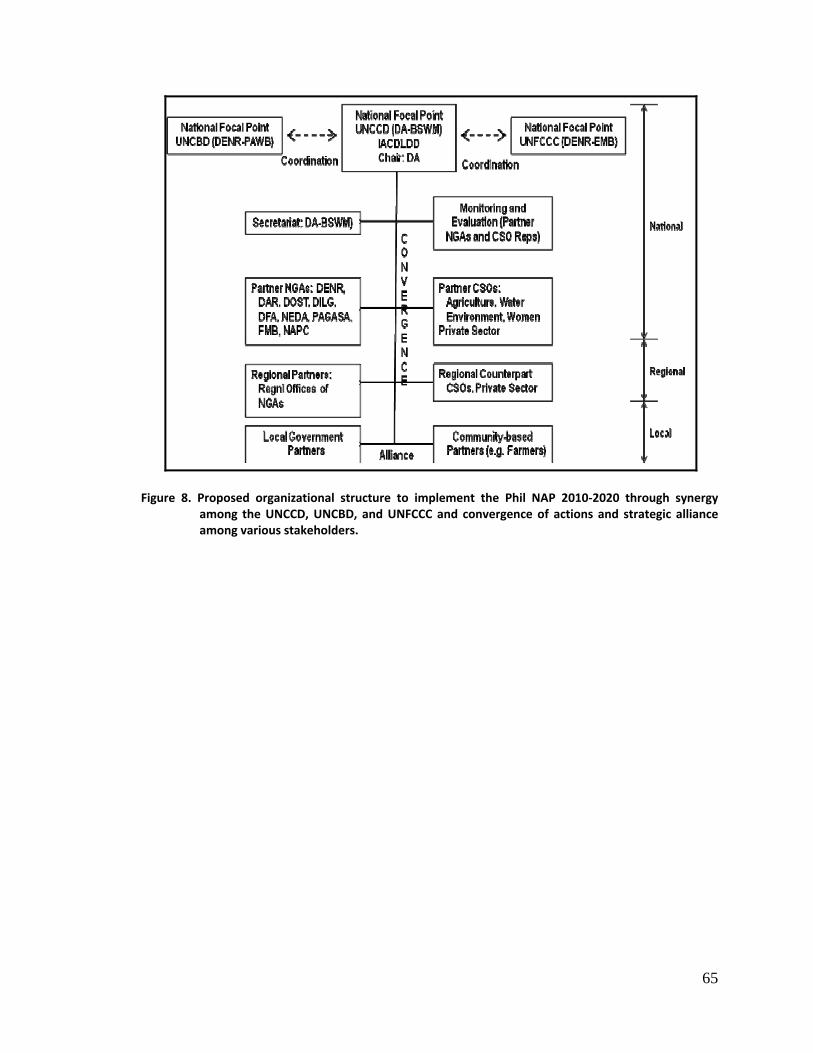
65
Figure 8. Proposed organizational structure to implement the Phil NAP 2010‐2020 through synergy
among the UNCCD, UNCBD, and UNFCCC and convergence of actions and strategic alliance among various stakeholders.
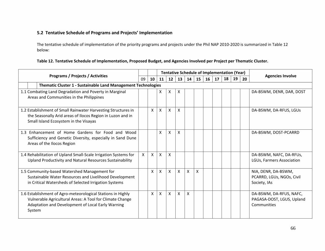
66
5.2 Tentative Schedule of Programs and Projects’ Implementation
The tentative schedule of implementation of the priority programs and projects under the Phil NAP 2010‐2020 is summarized in Table 12 below: Table 12. Tentative Schedule of Implementation, Proposed Budget, and Agencies Involved per Project per Thematic Cluster.
Programs / Projects / Activities Tentative Schedule of Implementation (Year)
Agencies Involve 09 10 11 12 13 14 15 16 17 18 19 20
Thematic Cluster 1 ‐ Sustainable Land Management Technologies
1.1 Combating Land Degradation and Poverty in Marginal Areas and Communities in the Philippines
X X X DA‐BSWM, DENR, DAR, DOST
1.2 Establishment of Small Rainwater Harvesting Structures in the Seasonally Arid areas of Ilocos Region in Luzon and in Small Island Ecosystem in the Visayas
X X X X DA‐BSWM, DA‐RFUS, LGUs
1.3 Enhancement of Home Gardens for Food and Wood Sufficiency and Genetic Diversity, especially in Sand Dune Areas of the Ilocos Region
X X X DA‐BSWM, DOST‐PCARRD
1.4 Rehabilitation of Upland Small‐Scale Irrigation Systems for Upland Productivity and Natural Resources Sustainability
X X X X DA‐BSWM, NAFC, DA‐RFUs, LGUs, Farmers Association
1.5 Community‐based Watershed Management for Sustainable Water Resources and Livelihood Development in Critical Watersheds of Selected Irrigation Systems
X X X X X X NIA, DENR, DA‐BSWM, PCARRD, LGUs, NGOs, Civil Society, IAs
1.6 Establishment of Agro‐meteorological Stations in Highly Vulnerable Agricultural Areas: A Tool for Climate Change Adaptation and Development of Local Early Warning System
X X X X X DA‐BSWM, DA‐RFUS, NAFC, PAGASA‐DOST, LGUS, Upland Communities
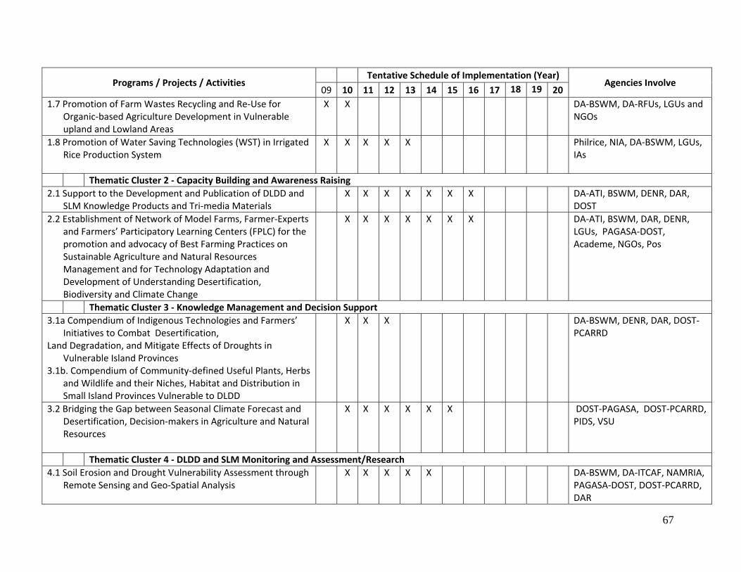
67
Programs / Projects / Activities Tentative Schedule of Implementation (Year)
Agencies Involve 09 10 11 12 13 14 15 16 17 18 19 20
1.7 Promotion of Farm Wastes Recycling and Re‐Use for Organic‐based Agriculture Development in Vulnerable upland and Lowland Areas
X X DA‐BSWM, DA‐RFUs, LGUs and NGOs
1.8 Promotion of Water Saving Technologies (WST) in Irrigated Rice Production System
X X X X X Philrice, NIA, DA‐BSWM, LGUs, IAs
Thematic Cluster 2 ‐ Capacity Building and Awareness Raising 2.1 Support to the Development and Publication of DLDD and
SLM Knowledge Products and Tri‐media Materials X X X X X X X DA‐ATI, BSWM, DENR, DAR,
DOST 2.2 Establishment of Network of Model Farms, Farmer‐Experts
and Farmers’ Participatory Learning Centers (FPLC) for the promotion and advocacy of Best Farming Practices on Sustainable Agriculture and Natural Resources Management and for Technology Adaptation and Development of Understanding Desertification, Biodiversity and Climate Change
X X X X X X X DA‐ATI, BSWM, DAR, DENR, LGUs, PAGASA‐DOST, Academe, NGOs, Pos
Thematic Cluster 3 ‐ Knowledge Management and Decision Support 3.1a Compendium of Indigenous Technologies and Farmers’
Initiatives to Combat Desertification, Land Degradation, and Mitigate Effects of Droughts in
Vulnerable Island Provinces 3.1b. Compendium of Community‐defined Useful Plants, Herbs
and Wildlife and their Niches, Habitat and Distribution in Small Island Provinces Vulnerable to DLDD
X X X DA‐BSWM, DENR, DAR, DOST‐PCARRD
3.2 Bridging the Gap between Seasonal Climate Forecast and Desertification, Decision‐makers in Agriculture and Natural Resources
X X X X X X DOST‐PAGASA, DOST‐PCARRD, PIDS, VSU
Thematic Cluster 4 ‐ DLDD and SLM Monitoring and Assessment/Research 4.1 Soil Erosion and Drought Vulnerability Assessment through
Remote Sensing and Geo‐Spatial Analysis X X X X X DA‐BSWM, DA‐ITCAF, NAMRIA,
PAGASA‐DOST, DOST‐PCARRD, DAR
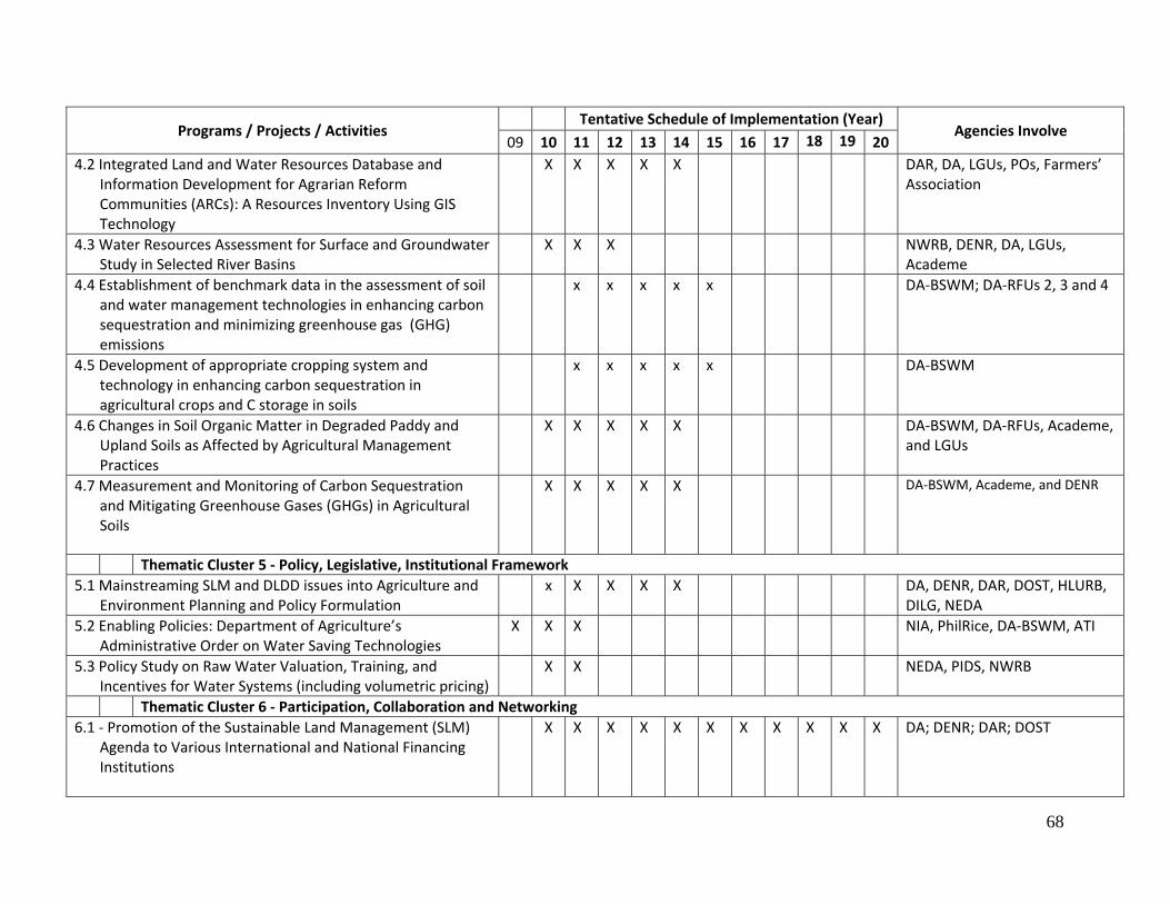
68
Programs / Projects / Activities Tentative Schedule of Implementation (Year)
Agencies Involve 09 10 11 12 13 14 15 16 17 18 19 20
4.2 Integrated Land and Water Resources Database and Information Development for Agrarian Reform Communities (ARCs): A Resources Inventory Using GIS Technology
X X X X X DAR, DA, LGUs, POs, Farmers’ Association
4.3 Water Resources Assessment for Surface and Groundwater Study in Selected River Basins
X X X NWRB, DENR, DA, LGUs, Academe
4.4 Establishment of benchmark data in the assessment of soil and water management technologies in enhancing carbon sequestration and minimizing greenhouse gas (GHG) emissions
x x x x x DA‐BSWM; DA‐RFUs 2, 3 and 4
4.5 Development of appropriate cropping system and technology in enhancing carbon sequestration in agricultural crops and C storage in soils
x x x x x DA‐BSWM
4.6 Changes in Soil Organic Matter in Degraded Paddy and Upland Soils as Affected by Agricultural Management Practices
X X X X X DA‐BSWM, DA‐RFUs, Academe, and LGUs
4.7 Measurement and Monitoring of Carbon Sequestration and Mitigating Greenhouse Gases (GHGs) in Agricultural Soils
X X X X X DA‐BSWM, Academe, and DENR
Thematic Cluster 5 ‐ Policy, Legislative, Institutional Framework 5.1 Mainstreaming SLM and DLDD issues into Agriculture and
Environment Planning and Policy Formulation x X X X X DA, DENR, DAR, DOST, HLURB,
DILG, NEDA 5.2 Enabling Policies: Department of Agriculture’s
Administrative Order on Water Saving Technologies X X X NIA, PhilRice, DA‐BSWM, ATI
5.3 Policy Study on Raw Water Valuation, Training, and Incentives for Water Systems (including volumetric pricing)
X X NEDA, PIDS, NWRB
Thematic Cluster 6 ‐ Participation, Collaboration and Networking 6.1 ‐ Promotion of the Sustainable Land Management (SLM)
Agenda to Various International and National Financing Institutions
X X X X X X X X X X X DA; DENR; DAR; DOST
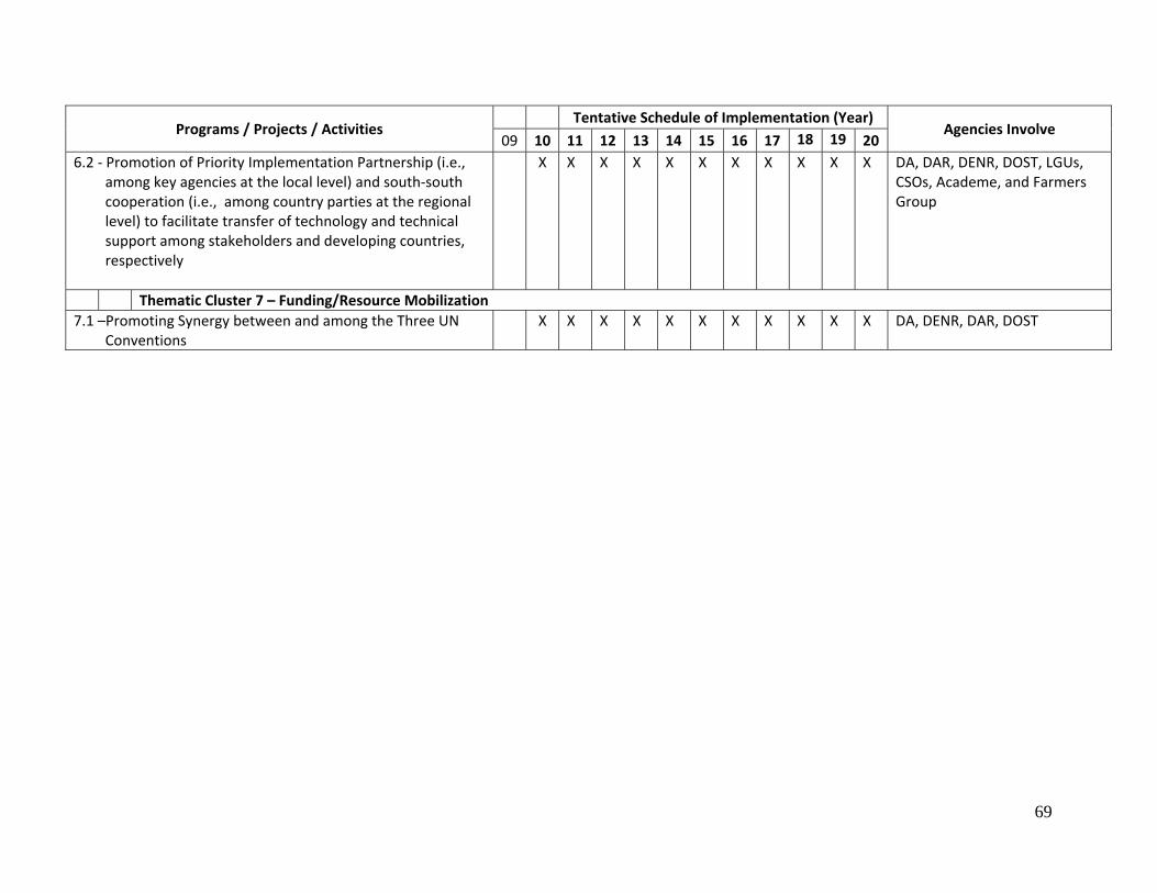
69
Programs / Projects / Activities Tentative Schedule of Implementation (Year)
Agencies Involve 09 10 11 12 13 14 15 16 17 18 19 20
6.2 ‐ Promotion of Priority Implementation Partnership (i.e., among key agencies at the local level) and south‐south cooperation (i.e., among country parties at the regional level) to facilitate transfer of technology and technical support among stakeholders and developing countries, respectively
X X X X X X X X X X X DA, DAR, DENR, DOST, LGUs, CSOs, Academe, and Farmers Group
Thematic Cluster 7 – Funding/Resource Mobilization 7.1 –Promoting Synergy between and among the Three UN
Conventions X X X X X X X X X X X DA, DENR, DAR, DOST
70
CHAPTER 6.0
Monitoring and Evaluation A rigorous monitoring and evaluation system, based on participatory principles, would be built into NAP implementation, making for not only accountability at various levels but also helping shape and refine program implementation methods over time.
Monitoring and evaluation arrangements would include:
• Semi‐annual progress reports on each project by the implementing agency concerned;
• At the national level, a stakeholders review workshop to be held annually to review status of implementation of individual projects, outputs achieved and the progress towards anticipated outcomes, along with constraints faced and areas of improvement needed; and
• Country reports by the National Focal Point every four years.
In addition, a mid‐term review is also provided for, at which time independent assessments based on the documented results as well as additional observations and/or studies would be carried out. A small professional team made up of individuals nominated by the IACLDD shall undertake this exercise, to be completed no later than five (5) years after project inception. Its main aims shall be to take stock of achievements as well as constraints, from strategic as well as operational perspectives; re‐examine program objectives; help fine‐tune approaches and methods; and ensure continuing relevance of various program interventions. Near the end of the project, a terminal evaluation will be undertaken to assess program achievements and overall impacts. Both the mid‐term review and terminal evaluation will be funded by the UNCCD. To aid in the monitoring and evaluation process of the implementation of the Phil NAP 2008‐2018, a Logical Framework is presented in Table 13. The Logical Framework presents the linkages among the development goal, strategic objectives, outputs and their corresponding activities, objectively verifiable indicators, means/sources of verification, and the risks and assumptions.
71
Table 13. Phil NAP 2010‐2020 Logical Framework.
NARRATIVE SUMMARY OBJECTIVELY VERIFIABLE INDICATORS MEANS/SOURCES OF
VERIFICATION RISKS AND ASSUMPTIONS
Higher Development Goals: • Reduce poverty and mitigate hunger • Ensure environmental sustainability
Specific Development Goal By 2020:Prevent desertification and land degradation, and mitigate the impacts of drought through a strengthened convergence of actions among national government agencies (NGAs), local government units (LGUs), civil society organizations (CSOs), and private sectors
Rate of land degradation in affected areas reduced (land degradation controlled) Inter‐agency committee on DLDD created and operated
NAP monitoring and evaluation reports Reports from a functional and operational IADLDD
NAP programs and projects are implemented as scheduled Supports from concerned stakeholders are provided as expected
Outcome 1 Improved living conditions of affected population Livelihood opportunities in affected population
created Increased awareness and resilience of affected rural communities against DLDD Enhanced capacities of affected population to mitigate adverse impacts of DLDD
Reports from government agencies and partners institutions/organizations Annual monitoring and evaluation report
Outcome 2 Improved conditions of affected ecosystems Enhanced physico‐chemical and biological
properties of specific affected lowland areas (i.e., project area) and improved cropping intensity by 50% Improved productivity of upland soils and increased adoption of sustainable land management technologies
Reports of government agencies and results of research projects (field verification) Field survey and site inspection reports
72
Outcome 3 Synergy with other Conventions Strengthened coordination mechanisms for
effective management (planning, implementation and monitoring) of DDLD programs
Regular consultations, meetings, and relevant coordination activities among the three Conventions at the country level
Outcome 4 Mobilized resources Established financing support mechanisms
(sourcing and allocation) Accomplishment report Financial statement
Output 1 Community‐based participatory learning awareness and advocacy campaign on DLDD promoted
Number of IEC campaigns conducted Number of IEC materials (in quad‐media forms) prepared and distributed Enhanced knowledge of affected communities and other stakeholders on DLDD including adaptation and mitigation strategies
Printed IEC materials Accomplishment reports
Availability of funds and other institutional support needs Community members are receptive to understand the importance of DLDD Demand for community participation is created
ACTIVITIES/PROJECTS INPUTSActivity 1.1 Development and publication of DLDD and SLM knowledge products and tri‐media materials
• Available knowledge products and quad‐media materials reviewed and evaluated for publication and dissemination
Activity 1.2 Establishment of Network of Model Farms, Farmer‐Experts and Farmers’ Participatory Learning Center (FPLC) for the Promotion of Best Farming Practices on Sustainable Agriculture and Natural Resources Management and for Technology Adaptation and Development of Understanding Desertification. Biodiversity and Climate Change
• List of Gawad Saka Awardees as Model Farmers • List of Farmer‐led Extension Workers and Learning Centers being managed by them • Learning Centers of State Colleges and Universities (SUCs) and their pool of experts • Farmers Training Modules and Guidelines
Output 2 Harmonized policies and implementation strategies
A. On policies: Number of relevant new policy/legislations proposed and passed;
Accomplishment reports Proposed policies/
No drastic changes in program direction and priorities and concerned agencies’ mandate
73
Number of existing relevant policies reviewed for effective and proper implementation to address DLDD Specifically on: ‐ Land use ‐ Organic‐based agriculture ‐ Water use and allocation (water saving technologies) ‐ Wastewater use and reuse ‐ Sustainable upland development B. On databases and information system Number of databases developed on DLDD and SLM C..On Implementation Arrangements: Clear institutional arrangement to facilitate implementation of programs and projects
TORs formulated and MOA’s signed Enhanced structure on planning, implementation, monitoring and evaluation at national, regional, and local levels
legislations/bills Documentation
Support and advocacy from policy makers are obtained
ACTIVITIES/PROJECTS INPUTSActivity 2.1 Mainstreaming SLM and DLDD Issues into Agriculture and Environment Planning and Policy Formulation
• Institutional arrangement to facilitate the mainstreaming process • Existing policies to address SLM and DLDD to facilitate harmonization efforts
Activity 2.2 Enabling Policies: Department of Agriculture’s Administrative Order on Water‐Saving Technologies (WST)
• Special Orders (SO) for the creation of a Technical Working Group (TWG) • Inventory of available water‐saving technologies • R & D results supporting the technical effectiveness of water‐saving technologies
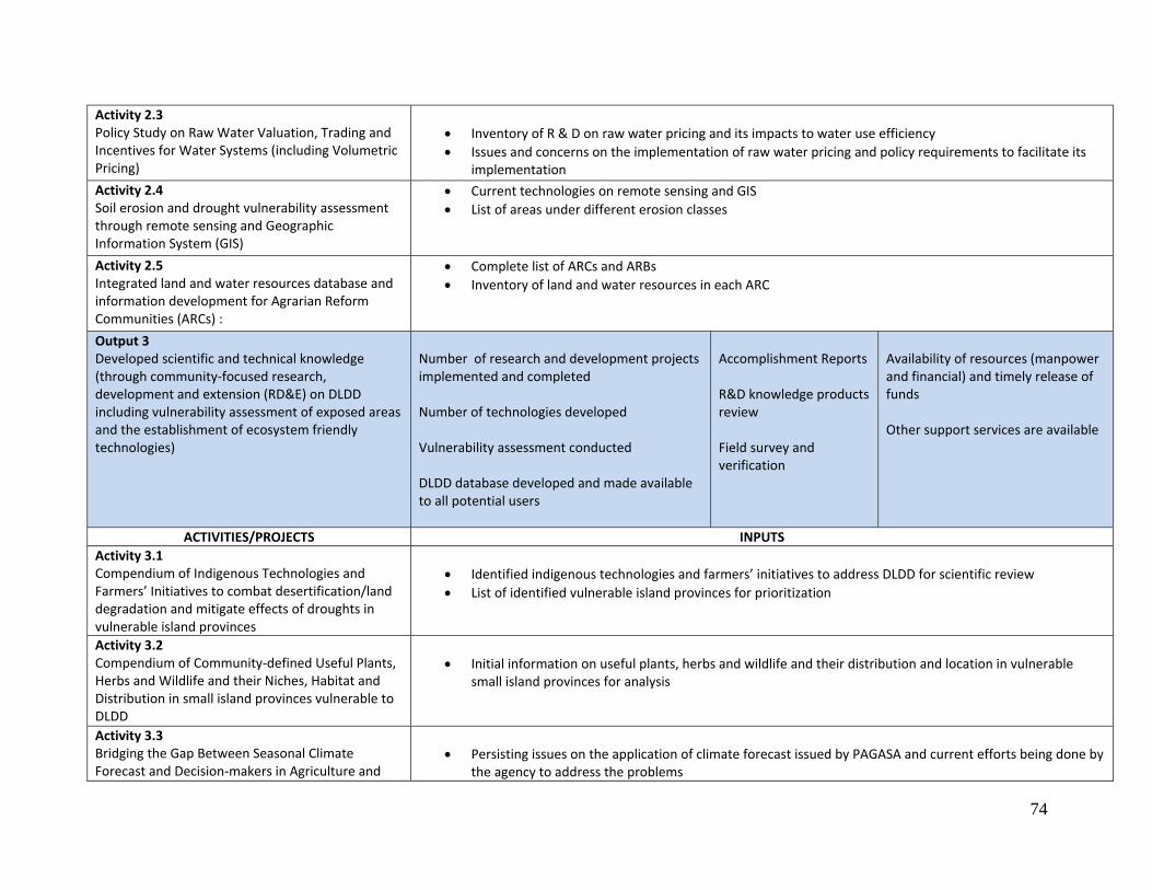
74
Activity 2.3 Policy Study on Raw Water Valuation, Trading and Incentives for Water Systems (including Volumetric Pricing)
• Inventory of R & D on raw water pricing and its impacts to water use efficiency • Issues and concerns on the implementation of raw water pricing and policy requirements to facilitate its
implementation Activity 2.4 Soil erosion and drought vulnerability assessment through remote sensing and Geographic Information System (GIS)
• Current technologies on remote sensing and GIS • List of areas under different erosion classes
Activity 2.5 Integrated land and water resources database and information development for Agrarian Reform Communities (ARCs) :
• Complete list of ARCs and ARBs • Inventory of land and water resources in each ARC
Output 3 Developed scientific and technical knowledge (through community‐focused research, development and extension (RD&E) on DLDD including vulnerability assessment of exposed areas and the establishment of ecosystem friendly technologies)
Number of research and development projects implemented and completed Number of technologies developed Vulnerability assessment conducted DLDD database developed and made available to all potential users
Accomplishment Reports R&D knowledge products review Field survey and verification
Availability of resources (manpower and financial) and timely release of funds Other support services are available
ACTIVITIES/PROJECTS INPUTSActivity 3.1 Compendium of Indigenous Technologies and Farmers’ Initiatives to combat desertification/land degradation and mitigate effects of droughts in vulnerable island provinces
• Identified indigenous technologies and farmers’ initiatives to address DLDD for scientific review • List of identified vulnerable island provinces for prioritization
Activity 3.2 Compendium of Community‐defined Useful Plants, Herbs and Wildlife and their Niches, Habitat and Distribution in small island provinces vulnerable to DLDD
• Initial information on useful plants, herbs and wildlife and their distribution and location in vulnerable small island provinces for analysis
Activity 3.3 Bridging the Gap Between Seasonal Climate Forecast and Decision‐makers in Agriculture and
• Persisting issues on the application of climate forecast issued by PAGASA and current efforts being done by the agency to address the problems
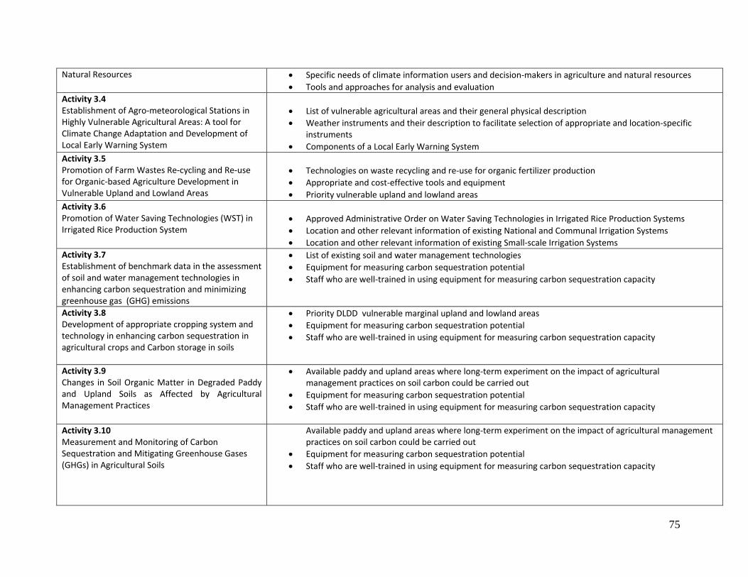
75
Natural Resources • Specific needs of climate information users and decision‐makers in agriculture and natural resources • Tools and approaches for analysis and evaluation
Activity 3.4 Establishment of Agro‐meteorological Stations in Highly Vulnerable Agricultural Areas: A tool for Climate Change Adaptation and Development of Local Early Warning System
• List of vulnerable agricultural areas and their general physical description • Weather instruments and their description to facilitate selection of appropriate and location‐specific
instruments • Components of a Local Early Warning System
Activity 3.5 Promotion of Farm Wastes Re‐cycling and Re‐use for Organic‐based Agriculture Development in Vulnerable Upland and Lowland Areas
• Technologies on waste recycling and re‐use for organic fertilizer production • Appropriate and cost‐effective tools and equipment • Priority vulnerable upland and lowland areas
Activity 3.6 Promotion of Water Saving Technologies (WST) in Irrigated Rice Production System
• Approved Administrative Order on Water Saving Technologies in Irrigated Rice Production Systems • Location and other relevant information of existing National and Communal Irrigation Systems • Location and other relevant information of existing Small‐scale Irrigation Systems
Activity 3.7 Establishment of benchmark data in the assessment of soil and water management technologies in enhancing carbon sequestration and minimizing greenhouse gas (GHG) emissions
• List of existing soil and water management technologies • Equipment for measuring carbon sequestration potential • Staff who are well‐trained in using equipment for measuring carbon sequestration capacity
Activity 3.8 Development of appropriate cropping system and technology in enhancing carbon sequestration in agricultural crops and Carbon storage in soils
• Priority DLDD vulnerable marginal upland and lowland areas • Equipment for measuring carbon sequestration potential • Staff who are well‐trained in using equipment for measuring carbon sequestration capacity
Activity 3.9 Changes in Soil Organic Matter in Degraded Paddy and Upland Soils as Affected by Agricultural Management Practices
• Available paddy and upland areas where long‐term experiment on the impact of agricultural management practices on soil carbon could be carried out
• Equipment for measuring carbon sequestration potential • Staff who are well‐trained in using equipment for measuring carbon sequestration capacity
Activity 3.10 Measurement and Monitoring of Carbon Sequestration and Mitigating Greenhouse Gases (GHGs) in Agricultural Soils
Available paddy and upland areas where long‐term experiment on the impact of agricultural management practices on soil carbon could be carried out
• Equipment for measuring carbon sequestration potential • Staff who are well‐trained in using equipment for measuring carbon sequestration capacity
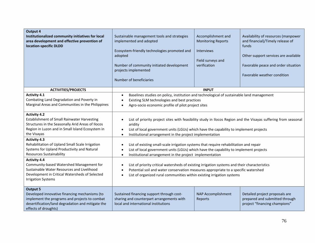
76
Output 4 Institutionalized community initiatives for local area development and effective prevention of location‐specific DLDD
Sustainable management tools and strategies implemented and adopted Ecosystem‐friendly technologies promoted and adopted Number of community initiated development projects implemented Number of beneficiaries
Accomplishment and Monitoring Reports Interviews Field surveys and verification
Availability of resources (manpower and financial)/Timely release of funds Other support services are available Favorable peace and order situation Favorable weather condition
ACTIVITIES/PROJECTS INPUTActivity 4.1 Combating Land Degradation and Poverty in Marginal Areas and Communities in the Philippines
• Baselines studies on policy, institution and technological of sustainable land management • Existing SLM technologies and best practices • Agro‐socio economic profile of pilot project sites
Activity 4.2 Establishment of Small Rainwater Harvesting Structures in the Seasonally Arid Areas of Ilocos Region in Luzon and in Small Island Ecosystem in the Visayas
• List of priority project sites with feasibility study in Ilocos Region and the Visayas suffering from seasonal aridity
• List of local government units (LGUs) which have the capability to implement projects • Institutional arrangement in the project implementation
Activity 4.3 Rehabilitation of Upland Small Scale Irrigation Systems for Upland Productivity and Natural Resources Sustainability
• List of existing small‐scale irrigation systems that require rehabilitation and repair • List of local government units (LGUs) which have the capability to implement projects • Institutional arrangement in the project implementation
Activity 4.4 Community‐based Watershed Management for Sustainable Water Resources and Livelihood Development in Critical Watersheds of Selected Irrigation Systems
• List of priority critical watersheds of existing irrigation systems and their characteristics • Potential soil and water conservation measures appropriate to a specific watershed • List of organized rural communities within existing irrigation systems
Output 5 Developed innovative financing mechanisms (to implement the programs and projects to combat desertification/land degradation and mitigate the effects of droughts)
Sustained financing support through cost‐sharing and counterpart arrangements with local and international institutions
NAP Accomplishment Reports
Detailed project proposals are prepared and submitted through project “financing champions”
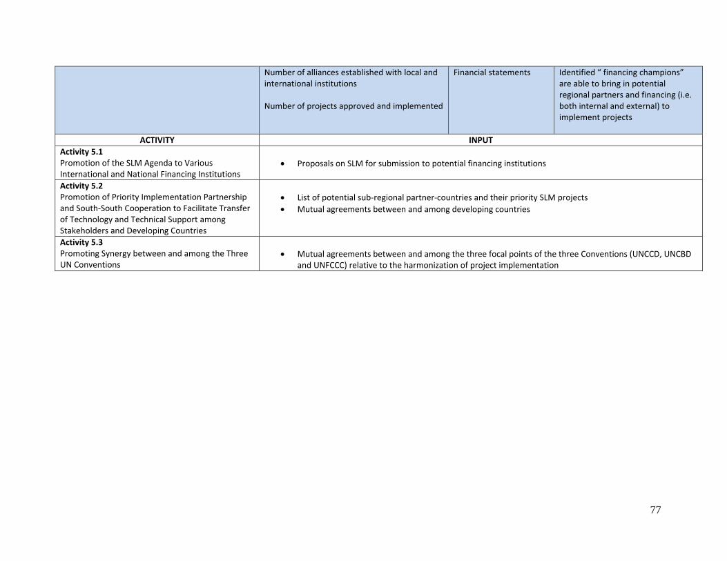
77
Number of alliances established with local and international institutions Number of projects approved and implemented
Financial statements Identified “ financing champions” are able to bring in potential regional partners and financing (i.e. both internal and external) to implement projects
ACTIVITY INPUTActivity 5.1 Promotion of the SLM Agenda to Various International and National Financing Institutions
• Proposals on SLM for submission to potential financing institutions
Activity 5.2 Promotion of Priority Implementation Partnership and South‐South Cooperation to Facilitate Transfer of Technology and Technical Support among Stakeholders and Developing Countries
• List of potential sub‐regional partner‐countries and their priority SLM projects • Mutual agreements between and among developing countries
Activity 5.3 Promoting Synergy between and among the Three UN Conventions
• Mutual agreements between and among the three focal points of the three Conventions (UNCCD, UNCBD and UNFCCC) relative to the harmonization of project implementation
78
Chapter 7.0. Expected Outputs (Deliverables of the NAP)
7.1 Attainment of the Strategic Objectives in the Long Term (Impacts) • Contribute to poverty alleviation of lowland and hillyland dwellers through improvement in farm
production and income.
• Contribute to rehabilitation of degraded hillylands and preservation of agro‐biodiversity. • Greater farmers’ participation and commitment to protect the natural resources addressing DLDD
with the establishment of Network of Model Farms cum Farmers Participatory Learning Center established and network of farmer‐experts capacitated as facilitators for the prevention of land degradation and rehabilitation of degraded lands at community level.
• Enabling environment improved through legislations and policy recommendations for the
prevention of land degradation and improvement of long‐term productivity and sustainability in seasonally arid areas of the Philippines.
• Increased knowledge and awareness of rural communities in sustaining the efforts to easily mitigate
desertification and rehabilitate land degradation. • Enhanced local community and LGU initiatives in sharing responsibilities and knowledge in
protecting the land and water resources. • Institutional capacity building and mainstreaming concerns on DLDD • Greater harmony and synergy with the other UN conventions
7.2 Attainment of the Operational Objectives in the Short‐term (Performance) 7.2.1 Sustainable Land Management (including Adaptation) • Generated 15,750 ha of new areas for upland agriculture to benefit about 7,500 upland farmers
through the provision of rainwater harvesting structure in the uplands of Ilocos Region and Panay Island.
• Rehabilitated 6,100 ha to benefit 4,200 farmers through the repair and improvement of existing small‐scale irrigation systems (SSIPs) in the upland ecosystem.
• Well‐managed 130,000 ha of critical watershed areas of existing national irrigation systems and
communal irrigation systems.
79
• Established 126 Agro‐meteorological Stations in strategic upland areas (i.e., sources of water for lowland agriculture) and 126 early warning systems for lowland population preparedness.
• Reduced usage of chemical fertilizers in about 200,000 ha through the farm wastes and residues
recycling and reuse and on‐farm composting technologies (e.g., vermin‐composting and modified rapid composting).
• Water savings of about 15 ‐ 30% in irrigated rice production areas of 1.5 M ha.
7.2.2 Capacity Building and Awareness Raising
• Published DLDD and SLM knowledge products, including developed quad‐media materials in local
dialects for dissemination to local communities.
• Networks of Model Farms cum Participatory Learning Centers in 16 Regions of the country to cater vulnerable areas to DLDD.
7.2.3 Knowledge Management and Decision Support • Compendium on indigenous knowledge and best practices and technologies relating to sustainable
resource utilization; knowledge products such as brochures and manuals on drought mitigating measures and land degradation prevention; and flyers/bulletins on early warning system and advisory on the occurrence, intensity and duration of El Niño effects and other calamities.
• Compendium of bio‐references for the selection of suitable agriculture commodities for agro‐
biodiversity and forest development. • Optimum utilization of seasonal climate information and forecasts and empowered farmers in
affected areas through Climate Field School (CFS). 7.2.4 DLDD and SLM Monitoring and Assessment • GIS‐derived maps on DLDD hotspots and maps of land use changes (i.e., satellite imageries) due to
impacts of SLM adoption.
• Land and Water Resources GIS database in selected Agrarian Reform Communities (ARCs) in Luzon, Visayas, and Mindanao.
• Surface Water and Groundwater Resources Inventory in selected river basins of the country.
80
7.2.5 Policy, Legislative, and Institutional Framework • Institutional structures and arrangement for mainstreaming DLDD and SLM at the national, regional,
and local levels.
• DA Administrative Order for mainstreaming Water Saving Technologies (WST) in Irrigated Rice Production System.
• Feasible and acceptable options on water pricing, trading, and incentive scheme. 7.2.6 Funding and Resource Mobilization • Innovative sources of finance and financing mechanisms including from the private sector, non‐
government organizations and civil society organizations.
• Partnership and Alliance Agreements in the implementation of priority DLDD projects at the country level; South‐south Cooperation Agreements at the Regional and Sub‐regional levels.
7.2.7 Participation, Collaboration, and Networking
• A synergy action plan document between and among the environmental Conventions
81
Annex 1: Past, Current and Continuing Efforts Aligned with the Phil NAP 2004‐2010.
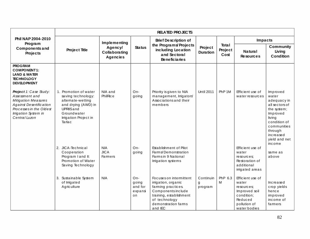
82
Phil NAP 2004-2010 Program
Components and Projects
RELATED PROJECTS
Project Title
Implementing Agency/
Collaborating Agencies
Status
Brief Description of the Programs/Projects
including Location and Sectoral Beneficiaries
Project Duration
Total Project
Cost
Impacts
Natural Resources
Community Living
Condition
PROGRAM COMPONENT 1: LAND & WATER TECHNOLOGY DEVELOPMENT Project 1: Case Study: Assessment and Mitigation Measures Against Desertification Processes in the Oldest Irrigation System in Central Luzon
1. Promotion of water
saving technology: alternate-wetting and drying (AWD) in UPRIIS and Groundwater Irrigation Project in Tarlac
2. JICA-Technical Cooperation Program I and II: Promotion of Water Saving Technology
3. Sustainable System of Irrigated Agriculture
NIA and PhilRice NIA JICA Farmers NIA
On-going On-going On-going and for expansion
Priority is given to NIA management, Irrigators’ Associations and their members Establishment of Pilot Farms/Demonstration Farms in 9 National Irrigation systems Focuses on intermittent irrigation, organic farming practices. Components include training, establishment of technology demonstration farms and IEC
Until 2011 Continuing program
PhP 1M PhP 6.3 M
Efficient use of water resources Efficient use of water resources; Restoration of additional irrigated areas Efficient use of water resources; Improved soil condition; Reduced pollution of water bodies
Improved water adequacy in all sectors of the system; Improved living condition of communities through increased yield and net income same as above
Increased crop yields hence improved income of farmers
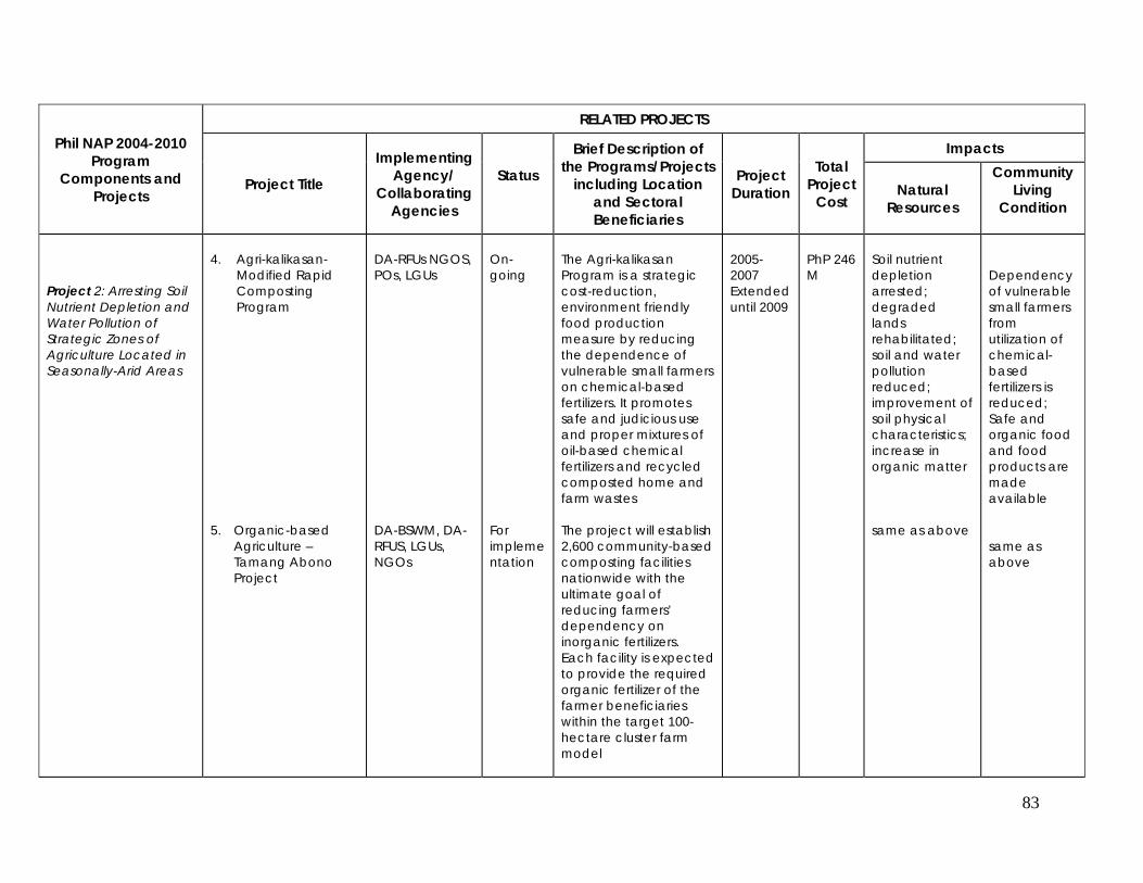
83
Phil NAP 2004-2010 Program
Components and Projects
RELATED PROJECTS
Project Title
Implementing Agency/
Collaborating Agencies
Status
Brief Description of the Programs/Projects
including Location and Sectoral Beneficiaries
Project Duration
Total Project
Cost
Impacts
Natural Resources
Community Living
Condition
Project 2: Arresting Soil Nutrient Depletion and Water Pollution of Strategic Zones of Agriculture Located in Seasonally-Arid Areas
4. Agri-kalikasan-
Modified Rapid Composting Program
5. Organic-based Agriculture – Tamang Abono Project
DA-RFUs NGOS, POs, LGUs DA-BSWM, DA-RFUS, LGUs, NGOs
On-going For implementation
The Agri-kalikasan Program is a strategic cost-reduction, environment friendly food production measure by reducing the dependence of vulnerable small farmers on chemical-based fertilizers. It promotes safe and judicious use and proper mixtures of oil-based chemical fertilizers and recycled composted home and farm wastes The project will establish 2,600 community-based composting facilities nationwide with the ultimate goal of reducing farmers’ dependency on inorganic fertilizers. Each facility is expected to provide the required organic fertilizer of the farmer beneficiaries within the target 100-hectare cluster farm model
2005-2007 Extended until 2009
PhP 246 M
Soil nutrient depletion arrested; degraded lands rehabilitated; soil and water pollution reduced; improvement of soil physical characteristics; increase in organic matter
same as above
Dependency of vulnerable small farmers from utilization of chemical-based fertilizers is reduced; Safe and organic food and food products are made available same as above
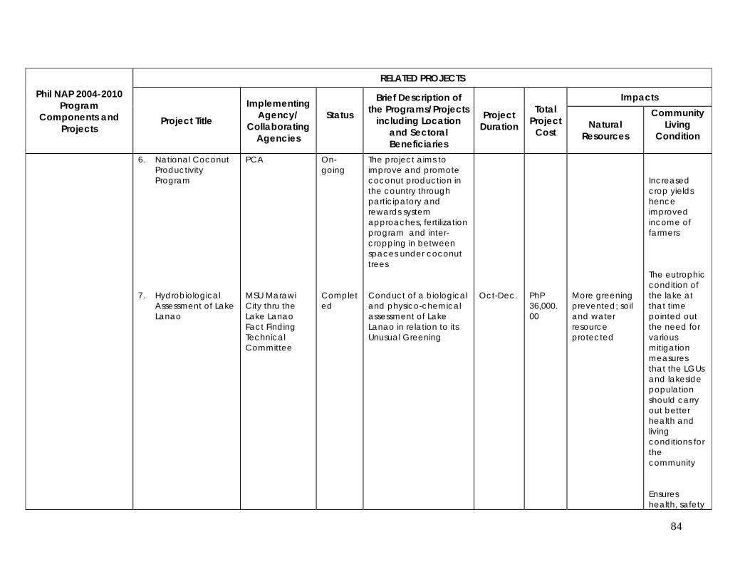
84
Phil NAP 2004-2010 Program
Components and Projects
RELATED PROJECTS
Project Title
Implementing Agency/
Collaborating Agencies
Status
Brief Description of the Programs/Projects
including Location and Sectoral Beneficiaries
Project Duration
Total Project
Cost
Impacts
Natural Resources
Community Living
Condition
6. National Coconut Productivity Program
7. Hydrobiological Assessment of Lake Lanao
PCA MSU Marawi City thru the Lake Lanao Fact Finding Technical Committee
On-going Completed
The project aims to improve and promote coconut production in the country through participatory and rewards system approaches, fertilization program and inter-cropping in between spaces under coconut trees Conduct of a biological and physico-chemical assessment of Lake Lanao in relation to its Unusual Greening
Oct-Dec.
PhP 36,000.00
More greening prevented; soil and water resource protected
Increased crop yields hence improved income of farmers The eutrophic condition of the lake at that time pointed out the need for various mitigation measures that the LGUs and lakeside population should carry out better health and living conditions for the community
Ensures health, safety
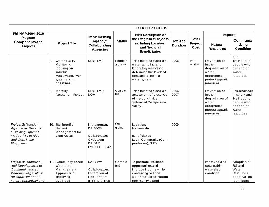
85
Phil NAP 2004-2010 Program
Components and Projects
RELATED PROJECTS
Project Title
Implementing Agency/
Collaborating Agencies
Status
Brief Description of the Programs/Projects
including Location and Sectoral Beneficiaries
Project Duration
Total Project
Cost
Impacts
Natural Resources
Community Living
Condition
8. Water quality
Monitoring focusing on industrial wastewater, river systems, and coastlines
DENR-EMB
Regular activity
This project focused on water sampling and laboratory analysis to determine the levels of contamination in a water system.
2006
PhP ~4.0 M
Prevention of further degradation of water ecosystem; protect aquatic resources
and livelihood of people who depend on water resources
Project 3: Precision Agriculture: Towards Sustaining Optimal Productivity of Rice and Corn in the Philippines
9. Mercury Assessment Project
10. Site Specific
Nutrient Management for Corn Areas
DENR-EMB; DOH Implementer: DA-BSWM Collaborators GMA-Corn DA-BAR, IPNI, UPLB, LGUs
Comple-ted On-going
This project focused on assessment of presence of mercury in river systems of Compostela Valley. Location: Nationwide Beneficiaries: Local Community (Corn producers), SUCs
2006-2007 2009-
Prevention of further degradation of water ecosystem; protect aquatic resources
Ensuresdhealth, safety and livelihood of people who depend on water resources
Project 4: Promotion and Development of Community-based Wilderness Agriculture for Improvement of Forest Productivity and
11. Community-based Watershed Management Approach in Improving Livelihood
DA-BSWM Collaborators: Federation of Free Farmers (FFF) , DA-RFUs
Comple-ted
To promote livelihood opportunities and improve income while conserving soil and water resources through community-based
Improved and sustainable watershed condition
Adoption of Soil and Water Resources conservation techniques
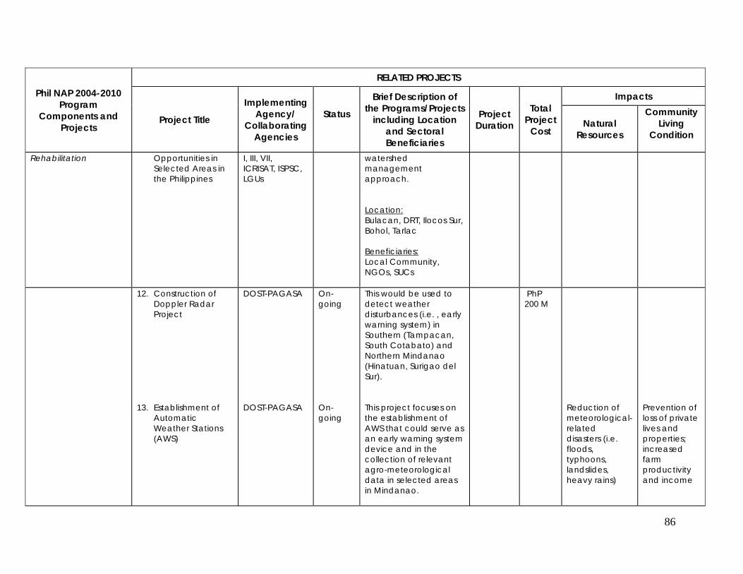
86
Phil NAP 2004-2010 Program
Components and Projects
RELATED PROJECTS
Project Title
Implementing Agency/
Collaborating Agencies
Status
Brief Description of the Programs/Projects
including Location and Sectoral Beneficiaries
Project Duration
Total Project
Cost
Impacts
Natural Resources
Community Living
Condition
Rehabilitation Opportunities in Selected Areas in the Philippines
I, III, VII, ICRISAT, ISPSC, LGUs
watershed management approach. Location: Bulacan, DRT, Ilocos Sur, Bohol, Tarlac Beneficiaries: Local Community, NGOs, SUCs
12. Construction of Doppler Radar Project
13. Establishment of
Automatic Weather Stations (AWS)
DOST-PAGASA DOST-PAGASA
On-going On-going
This would be used to detect weather disturbances (i.e. , early warning system) in Southern (Tampacan, South Cotabato) and Northern Mindanao (Hinatuan, Surigao del Sur). This project focuses on the establishment of AWS that could serve as an early warning system device and in the collection of relevant agro-meteorological data in selected areas in Mindanao.
PhP 200 M
Reduction of meteorological-related disasters (i.e. floods, typhoons, landslides, heavy rains)
Prevention of loss of private lives and properties; increased farm productivity and income
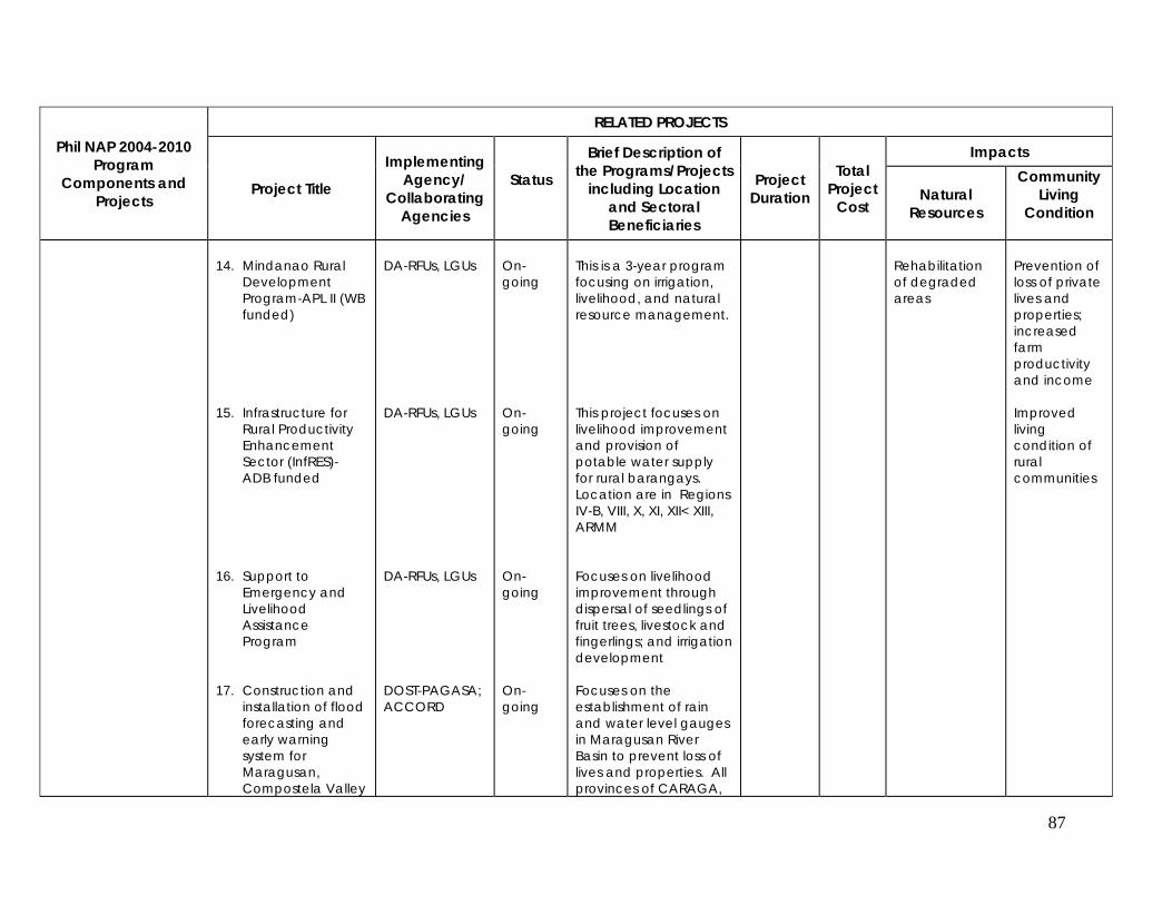
87
Phil NAP 2004-2010 Program
Components and Projects
RELATED PROJECTS
Project Title
Implementing Agency/
Collaborating Agencies
Status
Brief Description of the Programs/Projects
including Location and Sectoral Beneficiaries
Project Duration
Total Project
Cost
Impacts
Natural Resources
Community Living
Condition
14. Mindanao Rural
Development Program-APL II (WB funded)
15. Infrastructure for
Rural Productivity Enhancement Sector (InfRES)- ADB funded
16. Support to
Emergency and Livelihood Assistance Program
17. Construction and
installation of flood forecasting and early warning system for Maragusan, Compostela Valley
DA-RFUs, LGUs DA-RFUs, LGUs DA-RFUs, LGUs DOST-PAGASA; ACCORD
On-going On-going On-going On-going
This is a 3-year program focusing on irrigation, livelihood, and natural resource management. This project focuses on livelihood improvement and provision of potable water supply for rural barangays. Location are in Regions IV-B, VIII, X, XI, XII< XIII, ARMM Focuses on livelihood improvement through dispersal of seedlings of fruit trees, livestock and fingerlings; and irrigation development Focuses on the establishment of rain and water level gauges in Maragusan River Basin to prevent loss of lives and properties. All provinces of CARAGA,
Rehabilitation of degraded areas
Prevention of loss of private lives and properties; increased farm productivity and income Improved living condition of rural communities
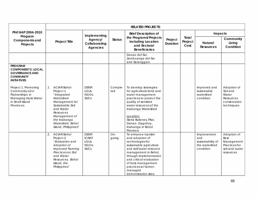
88
Phil NAP 2004-2010 Program
Components and Projects
RELATED PROJECTS
Project Title
Implementing Agency/
Collaborating Agencies
Status
Brief Description of the Programs/Projects
including Location and Sectoral Beneficiaries
Project Duration
Total Project
Cost
Impacts
Natural Resources
Community Living
Condition
Davao del Sur, Zamboanga del Sur and Saranggani
PROGRAM COMPONENT 2: LOCAL GOVERNANCE AND COMMUNITY INITIATIVES
Project 1. Promoting Community-LGU Partnerships in Managing Karst Water in Small Island Provinces
1. ACIAR Bohol Project-1 “Integrated Watershed Management for Sustainable Soil and Water Resources Management of the Inabanga Watershed, Bohol Island, Philippines”
DENR LGUs NGOs SUCs
Comple-ted
To develop strategies for agricultural land and water management practices to protect the quality of sensitive water resources of the Inabanga Watershed Location: Sierra Bullones, Pilar, Danao, Dagohoy, Inabanga in Bohol Province
Improved and sustainable watershed condition
Adoption of Soil and Water Resources conservation techniques
2. ACIAR Bohol Project-2 “Evaluation and Adoption of Improved Farming Practices on Soil and Water Resources, Bohol Island, the Philippines”
DENR ICRAF LGUs NGOs SUCs
On-going
To enhance transfer and adoption of technologies for sustainable agriculture and soil/water resource management in Bohol, through implementation and critical evaluation of best management practices at farmer-managed demonstration sites.
Improvement and sustainability of the watershed condition
Adoption of Best Management Practices for soil and water resources
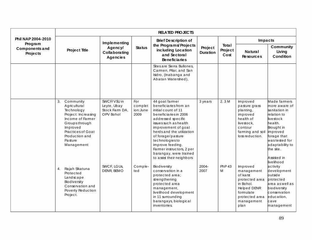
89
Phil NAP 2004-2010 Program
Components and Projects
RELATED PROJECTS
Project Title
Implementing Agency/
Collaborating Agencies
Status
Brief Description of the Programs/Projects
including Location and Sectoral Beneficiaries
Project Duration
Total Project
Cost
Impacts
Natural Resources
Community Living
Condition
Sites are Sierra Bullones, Carmen, Pilar, and San Isidro, (Inabanga and Abatan Watershed),
3. Community Agricultural Technology Project: Increasing Income of Farmer Groups through Improved Practices of Goat Production and Pasture Management
4. Rajah Sikatuna Protected Landscape Biodiversity Conservation and Poverty Reduction Project.
SWCF/VSU in Leyte, Ubay Stock Farm DA, OPV Bohol SWCF, LGUs, DENR, BEMO
For completion:June 2009 Comple-ted
44 goat farmer beneficiaries from an initial count of 11 beneficiaries in 2006 addressed specific issues such as health improvement of goat herds and the utilization of forage/pasture technologies to improve feeding. Farmer instructors, 2 per barangay, were trained to assist their neighbors Biodiversity conservation in a protected area; strengthening protected area management, livelihood development in 11 surrounding barangays, biological inventories.
3 years 2004-2007
2. 3 M PhP 43 M
Improved pasture grass planting, improved health of livestock, contour farming and soil loss reduction. Improved management of karst protected area in Bohol. Helped DENR formulate protected area management plan
Made farmers more aware of sanitation in relation to livestock health. Brought in improved forage that was tested for adaptability to the site. Assisted in livelihood activity development outside protected area as well as biodiversity conservation education, cave management
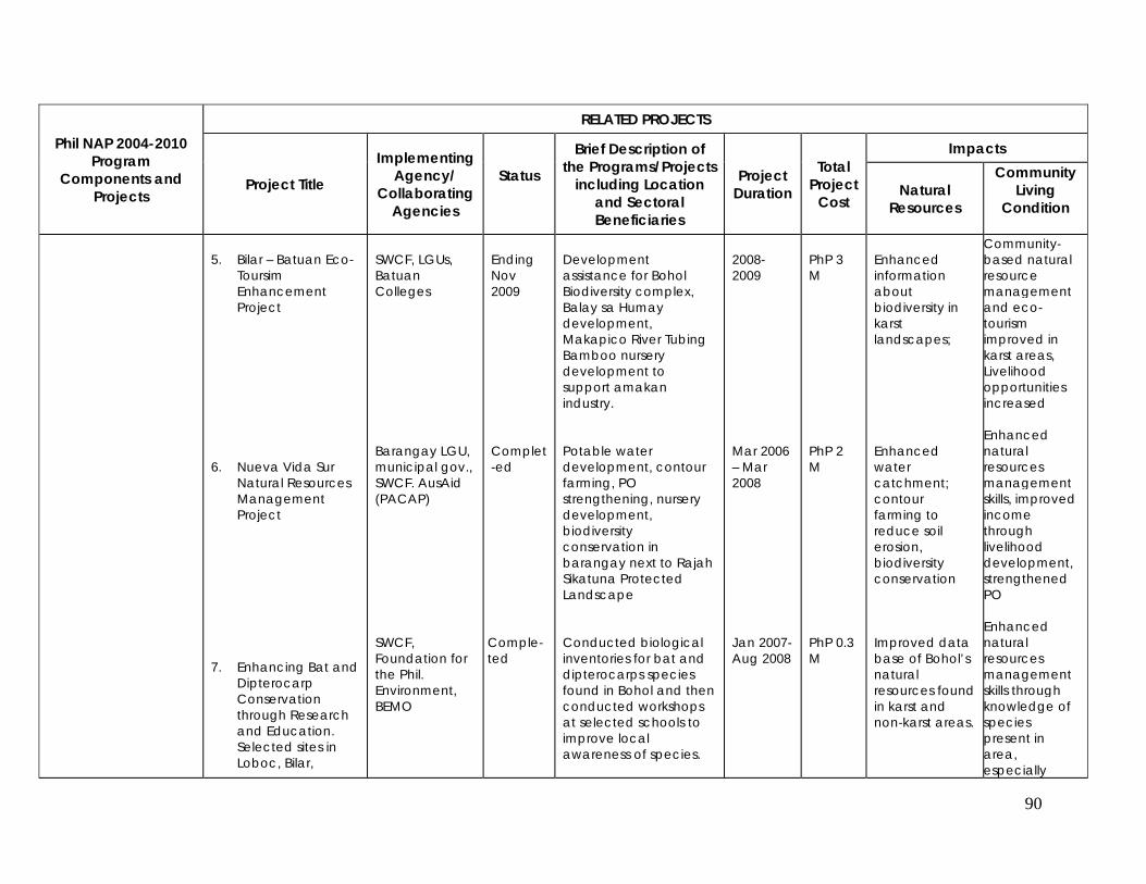
90
Phil NAP 2004-2010 Program
Components and Projects
RELATED PROJECTS
Project Title
Implementing Agency/
Collaborating Agencies
Status
Brief Description of the Programs/Projects
including Location and Sectoral Beneficiaries
Project Duration
Total Project
Cost
Impacts
Natural Resources
Community Living
Condition
5. Bilar – Batuan Eco-
Toursim Enhancement Project
6. Nueva Vida Sur
Natural Resources Management Project
7. Enhancing Bat and
Dipterocarp Conservation through Research and Education. Selected sites in Loboc, Bilar,
SWCF, LGUs, Batuan Colleges Barangay LGU, municipal gov., SWCF. AusAid (PACAP) SWCF, Foundation for the Phil. Environment, BEMO
Ending Nov 2009 Complet-ed Comple-ted
Development assistance for Bohol Biodiversity complex, Balay sa Humay development, Makapico River Tubing Bamboo nursery development to support amakan industry. Potable water development, contour farming, PO strengthening, nursery development, biodiversity conservation in barangay next to Rajah Sikatuna Protected Landscape Conducted biological inventories for bat and dipterocarps species found in Bohol and then conducted workshops at selected schools to improve local awareness of species.
2008-2009 Mar 2006 – Mar 2008 Jan 2007- Aug 2008
PhP 3 M PhP 2 M PhP 0.3 M
Enhanced information about biodiversity in karst landscapes; Enhanced water catchment; contour farming to reduce soil erosion, biodiversity conservation Improved data base of Bohol’s natural resources found in karst and non-karst areas.
Community-based natural resource management and eco-tourism improved in karst areas, Livelihood opportunities increased Enhanced natural resources management skills, improved income through livelihood development, strengthened PO Enhanced natural resources management skills through knowledge of species present in area, especially
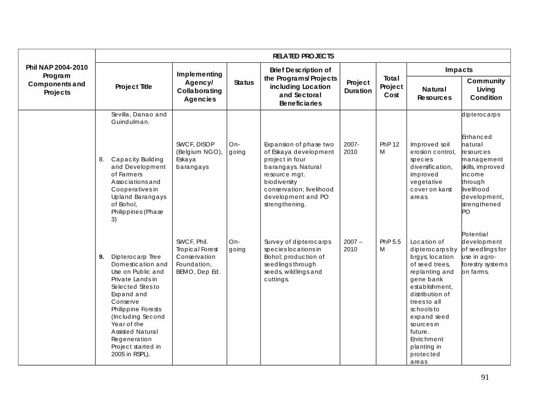
91
Phil NAP 2004-2010 Program
Components and Projects
RELATED PROJECTS
Project Title
Implementing Agency/
Collaborating Agencies
Status
Brief Description of the Programs/Projects
including Location and Sectoral Beneficiaries
Project Duration
Total Project
Cost
Impacts
Natural Resources
Community Living
Condition
Sevilla, Danao and Guindulman.
8. Capacity Building and Development of Farmers Associations and Cooperatives in Upland Barangays of Bohol, Philippines (Phase 3)
9. Dipterocarp Tree
Domestication and Use on Public and Private Lands in Selected Sites to Expand and Conserve Philippine Forests (Including Second Year of the Assisted Natural Regeneration Project started in 2005 in RSPL).
SWCF, DISOP (Belgium NGO), Eskaya barangays SWCF, Phil. Tropical Forest Conservation Foundation, BEMO, Dep Ed.
On-going On-going
Expansion of phase two of Eskaya development project in four barangays. Natural resource mgt. biodiversity conservation; livelihood development and PO strengthening. Survey of dipterocarps species locations in Bohol; production of seedlings through seeds, wildlings and cuttings.
2007-2010 2007 – 2010
PhP 12 M PhP 5.5 M
Improved soil erosion control, species diversification, improved vegetative cover on karst areas. Location of dipterocarps by brgys; location of seed trees, replanting and gene bank establishment, distribution of trees to all schools to expand seed sources in future. Enrichment planting in protected areas
dipterocarps Enhanced natural resources management skills, improved income through livelihood development, strengthened PO Potential development of seedlings for use in agro-forestry systems on farms.
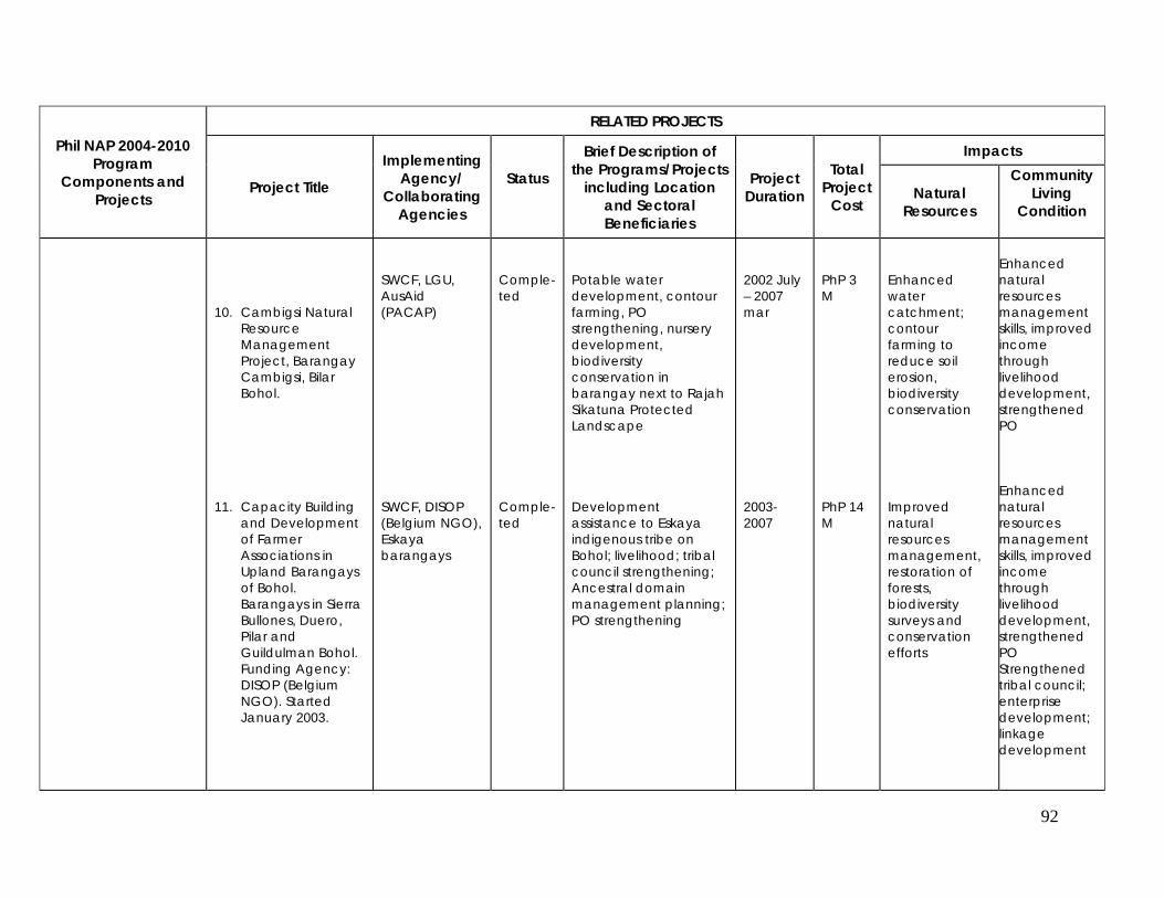
92
Phil NAP 2004-2010 Program
Components and Projects
RELATED PROJECTS
Project Title
Implementing Agency/
Collaborating Agencies
Status
Brief Description of the Programs/Projects
including Location and Sectoral Beneficiaries
Project Duration
Total Project
Cost
Impacts
Natural Resources
Community Living
Condition
10. Cambigsi Natural
Resource Management Project, Barangay Cambigsi, Bilar Bohol.
11. Capacity Building
and Development of Farmer Associations in Upland Barangays of Bohol. Barangays in Sierra Bullones, Duero, Pilar and Guildulman Bohol. Funding Agency: DISOP (Belgium NGO). Started January 2003.
SWCF, LGU, AusAid (PACAP) SWCF, DISOP (Belgium NGO), Eskaya barangays
Comple-ted Comple-ted
Potable water development, contour farming, PO strengthening, nursery development, biodiversity conservation in barangay next to Rajah Sikatuna Protected Landscape Development assistance to Eskaya indigenous tribe on Bohol; livelihood; tribal council strengthening; Ancestral domain management planning; PO strengthening
2002 July – 2007 mar 2003-2007
PhP 3 M PhP 14 M
Enhanced water catchment; contour farming to reduce soil erosion, biodiversity conservation Improved natural resources management, restoration of forests, biodiversity surveys and conservation efforts
Enhanced natural resources management skills, improved income through livelihood development, strengthened PO Enhanced natural resources management skills, improved income through livelihood development, strengthened PO Strengthened tribal council; enterprise development; linkage development
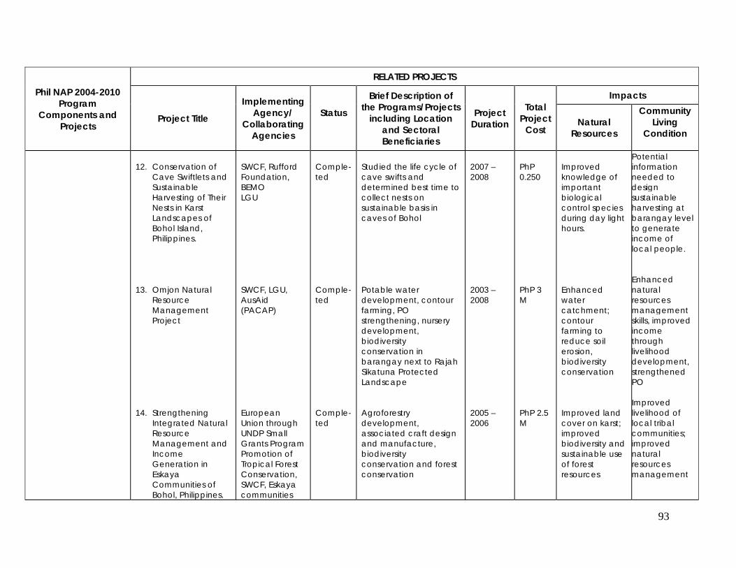
93
Phil NAP 2004-2010 Program
Components and Projects
RELATED PROJECTS
Project Title
Implementing Agency/
Collaborating Agencies
Status
Brief Description of the Programs/Projects
including Location and Sectoral Beneficiaries
Project Duration
Total Project
Cost
Impacts
Natural Resources
Community Living
Condition
12. Conservation of
Cave Swiftlets and Sustainable Harvesting of Their Nests in Karst Landscapes of Bohol Island, Philippines.
13. Omjon Natural
Resource Management Project
14. Strengthening
Integrated Natural Resource Management and Income Generation in Eskaya Communities of Bohol, Philippines.
SWCF, Rufford Foundation, BEMO LGU SWCF, LGU, AusAid (PACAP) European Union through UNDP Small Grants Program Promotion of Tropical Forest Conservation, SWCF, Eskaya communities
Comple-ted Comple-ted Comple-ted
Studied the life cycle of cave swifts and determined best time to collect nests on sustainable basis in caves of Bohol Potable water development, contour farming, PO strengthening, nursery development, biodiversity conservation in barangay next to Rajah Sikatuna Protected Landscape Agroforestry development, associated craft design and manufacture, biodiversity conservation and forest conservation
2007 – 2008 2003 – 2008 2005 – 2006
PhP 0.250 PhP 3 M PhP 2.5 M
Improved knowledge of important biological control species during day light hours. Enhanced water catchment; contour farming to reduce soil erosion, biodiversity conservation Improved land cover on karst; improved biodiversity and sustainable use of forest resources
Potential information needed to design sustainable harvesting at barangay level to generate income of local people. Enhanced natural resources management skills, improved income through livelihood development, strengthened PO Improved livelihood of local tribal communities; improved natural resources management
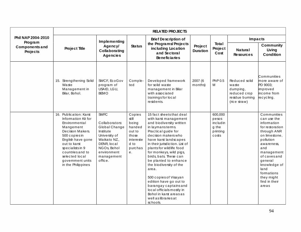
94
Phil NAP 2004-2010 Program
Components and Projects
RELATED PROJECTS
Project Title
Implementing Agency/
Collaborating Agencies
Status
Brief Description of the Programs/Projects
including Location and Sectoral Beneficiaries
Project Duration
Total Project
Cost
Impacts
Natural Resources
Community Living
Condition
15. Strengthening Solid
Waste Management in Bilar, Bohol.
SWCF, EcoGov program of USAID, LGU, BEMO
Comple-ted
Developed framework for solid waste management in Bilar with associated trainings for local residents.
2007 (6 months)
PhP 0.5 M
Reduced solid waste dumping, reduced crop residue burning (rice straw)
Communities more aware of PD 9003; improved income from recycling.
16. Publication: Karst Information Kit for Environmental Mangement Decision Makers. 500 copies in English have gone out to karst specialists in 9 countries and to selected local government units in the Philippines
SWFC Collaborators: Global Change Institute University of Waikato NZ., DENR, local NGOs, Bohol environment management office.
Copies still being handed out to those interested to purchase.
15 fact sheets that deal with karst management and biodiversity written in laymans terms. Practical guide for decision makers who have karst landscapes in their jurisdiction. List of plants for wildlife food for monkeys, wild pigs, birds, bats. These can be planted to enhance the biodiversity of the area. 500 copies of Visayan edition have go out to barangay captains and local officials mostly in Bohol in karst areas as well as libraries at schools.
600,000 pesos including the printing costs
Communities can use the information for restoration through ANR on limestone, pollution awareness, and management of caves and general knowledge of land formations they might find in their areas
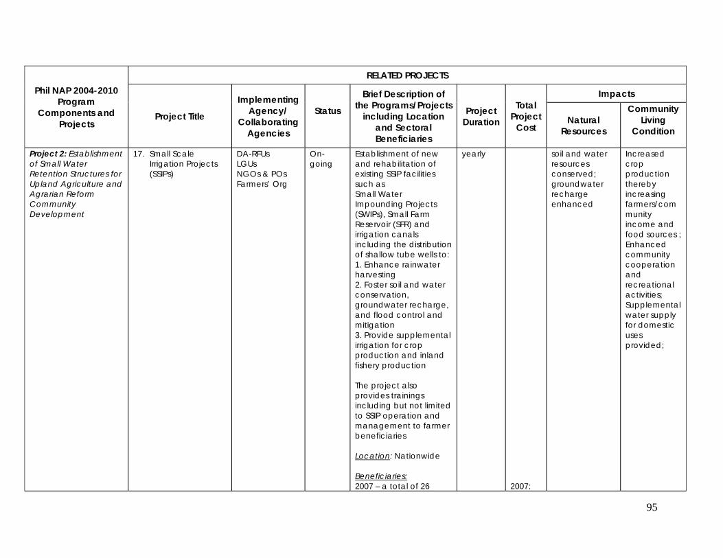
95
Phil NAP 2004-2010 Program
Components and Projects
RELATED PROJECTS
Project Title
Implementing Agency/
Collaborating Agencies
Status
Brief Description of the Programs/Projects
including Location and Sectoral Beneficiaries
Project Duration
Total Project
Cost
Impacts
Natural Resources
Community Living
Condition
Project 2: Establishment of Small Water Retention Structures for Upland Agriculture and Agrarian Reform Community Development
17. Small Scale Irrigation Projects (SSIPs)
DA-RFUs LGUs NGOs & POs Farmers’ Org
On-going
Establishment of new and rehabilitation of existing SSIP facilities such as Small Water Impounding Projects (SWIPs), Small Farm Reservoir (SFR) and irrigation canals including the distribution of shallow tube wells to: 1. Enhance rainwater harvesting 2. Foster soil and water conservation, groundwater recharge, and flood control and mitigation 3. Provide supplemental irrigation for crop production and inland fishery production The project also provides trainings including but not limited to SSIP operation and management to farmer beneficiaries Location: Nationwide Beneficiaries: 2007 – a total of 26
yearly 2007:
soil and water resources conserved; groundwater recharge enhanced
Increased crop production thereby increasing farmers/community income and food sources ; Enhanced community cooperation and recreational activities; Supplemental water supply for domestic uses provided;
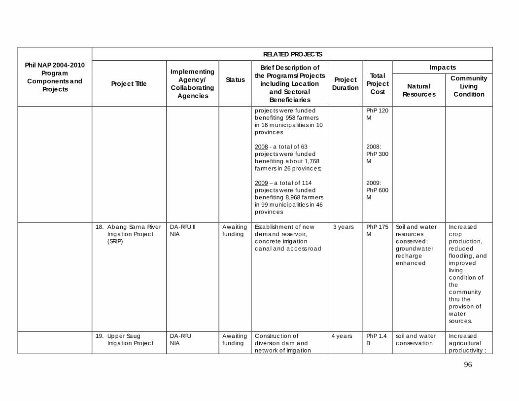
96
Phil NAP 2004-2010 Program
Components and Projects
RELATED PROJECTS
Project Title
Implementing Agency/
Collaborating Agencies
Status
Brief Description of the Programs/Projects
including Location and Sectoral Beneficiaries
Project Duration
Total Project
Cost
Impacts
Natural Resources
Community Living
Condition
projects were funded benefiting 958 farmers in 16 municipalities in 10 provinces 2008 - a total of 63 projects were funded benefiting about 1,768 farmers in 26 provinces; 2009 – a total of 114 projects were funded benefiting 8,968 farmers in 99 municipalities in 46 provinces
PhP 120 M 2008: PhP 300 M 2009: PhP 600 M
18. Abang Sama River Irrigation Project (SRIP)
DA-RFU II NIA
Awaiting funding
Establishment of new demand reservoir, concrete irrigation canal and access road
3 years PhP 175 M
Soil and water resources conserved; groundwater recharge enhanced
Increased crop production, reduced flooding, and improved living condition of the community thru the provision of water sources.
19. Upper Saug Irrigation Project
DA-RFU NIA
Awaiting funding
Construction of diversion dam and network of irrigation
4 years PhP 1.4 B
soil and water conservation
Increased agricultural productivity ;
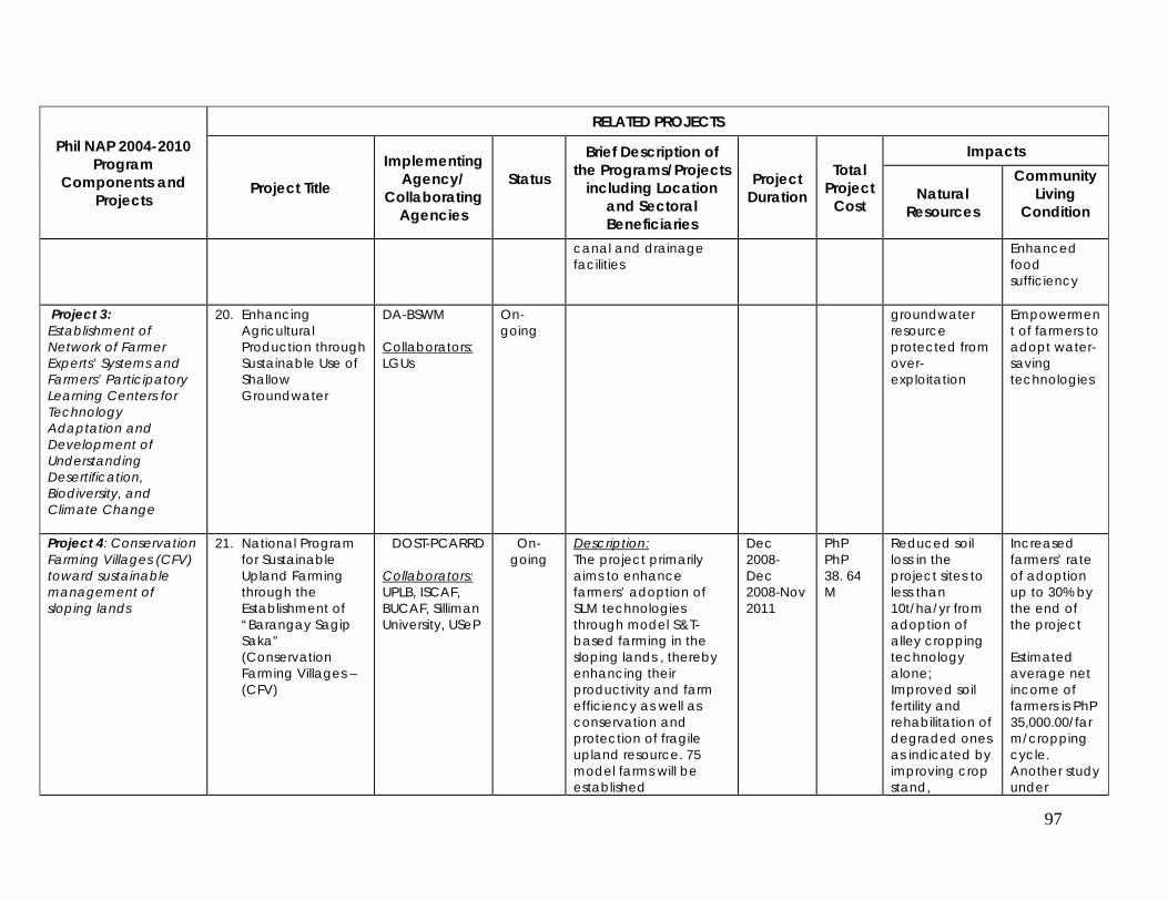
97
Phil NAP 2004-2010 Program
Components and Projects
RELATED PROJECTS
Project Title
Implementing Agency/
Collaborating Agencies
Status
Brief Description of the Programs/Projects
including Location and Sectoral Beneficiaries
Project Duration
Total Project
Cost
Impacts
Natural Resources
Community Living
Condition
canal and drainage facilities
Enhanced food sufficiency
Project 3: Establishment of Network of Farmer Experts’ Systems and Farmers’ Participatory Learning Centers for Technology Adaptation and Development of Understanding Desertification, Biodiversity, and Climate Change
20. Enhancing Agricultural Production through Sustainable Use of Shallow Groundwater
DA-BSWM Collaborators: LGUs
On-going
groundwater resource protected from over-exploitation
Empowerment of farmers to adopt water-saving technologies
Project 4: Conservation Farming Villages (CFV) toward sustainable management of sloping lands
21. National Program for Sustainable Upland Farming through the Establishment of “Barangay Sagip Saka” (Conservation Farming Villages – (CFV)
DOST-PCARRD
Collaborators: UPLB, ISCAF, BUCAF, Silliman University, USeP
On-going
Description: The project primarily aims to enhance farmers’ adoption of SLM technologies through model S&T-based farming in the sloping lands , thereby enhancing their productivity and farm efficiency as well as conservation and protection of fragile upland resource. 75 model farms will be established
Dec 2008- Dec 2008-Nov 2011
PhP PhP 38. 64 M
Reduced soil loss in the project sites to less than 10t/ha/yr from adoption of alley cropping technology alone; Improved soil fertility and rehabilitation of degraded ones as indicated by improving crop stand,
Increased farmers’ rate of adoption up to 30% by the end of the project Estimated average net income of farmers is PhP 35,000.00/farm/cropping cycle. Another study under
98
Phil NAP 2004-2010 Program
Components and Projects
RELATED PROJECTS
Project Title
Implementing Agency/
Collaborating Agencies
Status
Brief Description of the Programs/Projects
including Location and Sectoral Beneficiaries
Project Duration
Total Project
Cost
Impacts
Natural Resources
Community Living
Condition
Location: The project covers five provinces: 1. Ifugao 2. Laguna 3. Albay 4. Negros Oriental 5. Davao del Norte Beneficiaries: 3,000 farmers 9,975 trained persons on SLM
appearance of terraces, reduced rate of surface velocity, & increased number of worms, among many others
ASIALAND project showed that with 0.6 ha average land cultivated to various crops, a farm could gain up to 70% increase in returns above cash cost
22. Upland Development Program
DENR-FMB
Collaborators: 1. NGOs 2. POs 3. LGUs 4. PAWB 5. DECS 6. DA
On-going
The Upland Development Program that will accelerate the restoration of the vital watershed and protected areas as well as simultaneously catalyze the improvement of the productivity of the uplands, mitigate hunger, engage upland communities, civil society and local government units in sustainable upland and forest management The investment under the Program aims to:
Jan 2009 – Dec 2009
PhP 1.5 B
Improved productivity and soil and water conservation functions; Rehabilitated and effectively managed forests, forestsland, watersheds, mangroves, protected areas, among others; Increased forest cover; Enhanced fuel wood and food
Increased farmers income and food sources Created additional livelihood sources Increased community capacity to sustainably manage local resources Increased community
99
Phil NAP 2004-2010 Program
Components and Projects
RELATED PROJECTS
Project Title
Implementing Agency/
Collaborating Agencies
Status
Brief Description of the Programs/Projects
including Location and Sectoral Beneficiaries
Project Duration
Total Project
Cost
Impacts
Natural Resources
Community Living
Condition
1. Create immediate additional incomes for upland households;
2. Develop and manage watersheds supporting the irrigation and municipal water systems, headwaters, mangroves, coastal zones, protected areas and protection forestlands ;
3. To pump prime local economy in the uplands where investment are made
4. Demonstrate measurable and verifiable positive effects on environmental services
production Improved water yield and quality of watersheds
awareness on sustainable upland and forest management
23. Integrated Soil Conservation Techno-Demo Guided Farm
BSWM Collaborators: LGUs
On-going
It aims to establish technology demonstration farms that showcase the adoption of soil and water conservation
Enhanced agricultural production and ecological balance; soil erosion
Increased crop production thereby increasing farmers/com
100
Phil NAP 2004-2010 Program
Components and Projects
RELATED PROJECTS
Project Title
Implementing Agency/
Collaborating Agencies
Status
Brief Description of the Programs/Projects
including Location and Sectoral Beneficiaries
Project Duration
Total Project
Cost
Impacts
Natural Resources
Community Living
Condition
farming practices and approaches in upland communities. Location: Bataan, Bulacan, Pangasinan For 2009, it was targeted that four new guided will be established in: Abra, Vizcaya, Zamboanga, Isabela Beneficiaries: upland farmers
mitigated and reduced; soil and water conservation enhanced
munity income and food sources
24. Farmer Field School: Season-long participatory Training on Conservation farming in different agro-climatic zones
BSWM Collaborators: LGUs
Training on sustainable farming practices for the lowland, hillyland, and upland areas Location: Tanay, Rizal Bulacan Bukidnon Beneficiaries: Farmers
Project 5: Local 25. Alternative Energy, Mamitua Saber Complet Alternatives were One and PhP 0.4 Trees and Income was
101
Phil NAP 2004-2010 Program
Components and Projects
RELATED PROJECTS
Project Title
Implementing Agency/
Collaborating Agencies
Status
Brief Description of the Programs/Projects
including Location and Sectoral Beneficiaries
Project Duration
Total Project
Cost
Impacts
Natural Resources
Community Living
Condition
Governance-Community Partnerships in Managing Degraded and Critical Multiple Watersheds: Case Studies in Mindanao and Luzon Trans-boundary River Systems
Food and Livelihood Sources towards Sustainable Management of the Bayug River Watershed, Brgy. Rogongon, Iligan City
Research Center, MSU (thru Dr. Carmelita G. Hansel); Funded by Philippine Tropical Forest Foundation Inc.
ed tested, specifically, solar panel cooker in lieu of wood-fired stove, solar-dried root crops, ube (climbing food vine) grown alongside trees as an economic crop, to show their feasibility in an upland barangay, Brgy. Rogongon, Iligan City. These alternatives were tested in place of usual practices (use of firewood, cultivation of usual food crops such as upland rice and corn and economic crops) that involve cutting of trees and clearing of forested/ wooded areas, so as to benefit not only the upland settlers but the environment. Livelihood was provided and reforestation promoted by purchasing native forest tree seedlings/ wildlings from the residents and distributing among them for planting. Other kinds of plants (Jatropha, mulberry, pili,
a half years (Dec. 16, 2006 to June 15, 2008)
M wooded/ forested areas were conserved. Soil erosion was prevented. Native forest trees and other kinds of plants were planted.
augmented from the sale of the native forest tree seedlings/ wildlings and from the harvest of the ubi grown alongside trees. Future income is foreseen from the native forest trees and other kinds of plants planted either as timber or as non-timber product (biofuel, silkworm feed, edible fruit, spice, etc.).
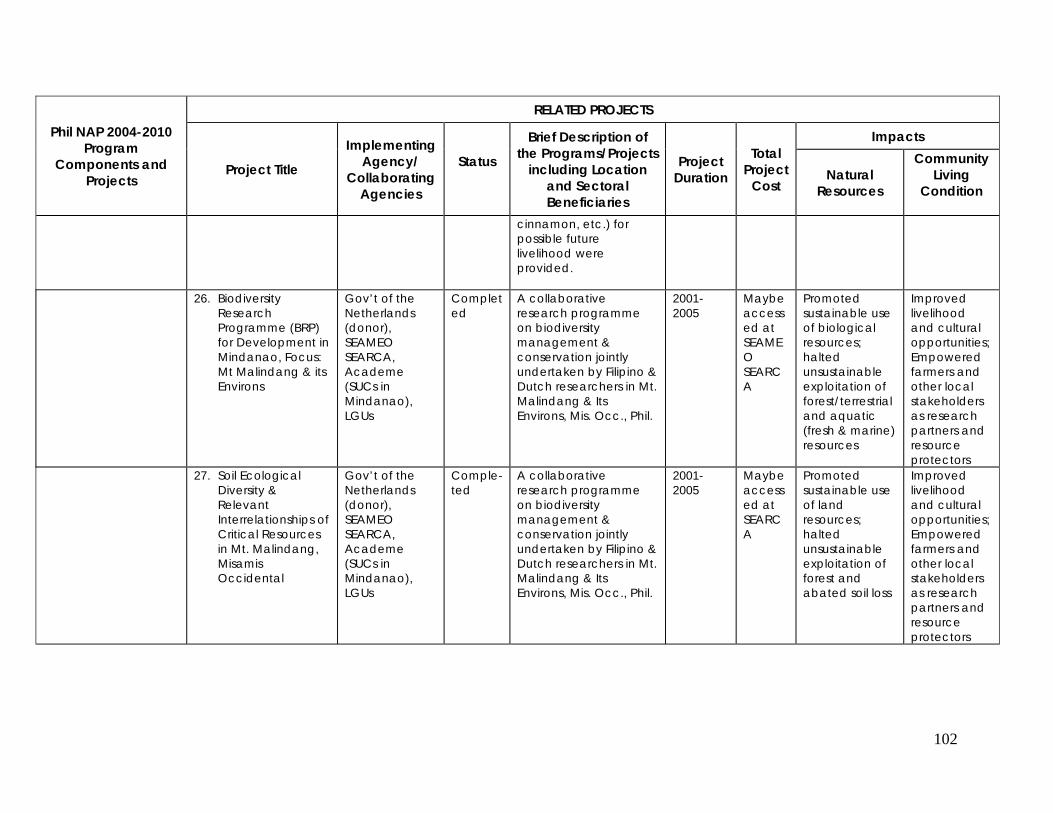
102
Phil NAP 2004-2010 Program
Components and Projects
RELATED PROJECTS
Project Title
Implementing Agency/
Collaborating Agencies
Status
Brief Description of the Programs/Projects
including Location and Sectoral Beneficiaries
Project Duration
Total Project
Cost
Impacts
Natural Resources
Community Living
Condition
cinnamon, etc.) for possible future livelihood were provided.
26. Biodiversity Research Programme (BRP) for Development in Mindanao, Focus: Mt Malindang & its Environs
Gov’t of the Netherlands (donor), SEAMEO SEARCA, Academe (SUCs in Mindanao), LGUs
Completed
A collaborative research programme on biodiversity management & conservation jointly undertaken by Filipino & Dutch researchers in Mt. Malindang & Its Environs, Mis. Occ., Phil.
2001-2005
Maybe accessed at SEAMEO SEARCA
Promoted sustainable use of biological resources; halted unsustainable exploitation of forest/terrestrial and aquatic (fresh & marine) resources
Improved livelihood and cultural opportunities; Empowered farmers and other local stakeholders as research partners and resource protectors
27. Soil Ecological Diversity & Relevant Interrelationships of Critical Resources in Mt. Malindang, Misamis Occidental
Gov’t of the Netherlands (donor), SEAMEO SEARCA, Academe (SUCs in Mindanao), LGUs
Comple-ted
A collaborative research programme on biodiversity management & conservation jointly undertaken by Filipino & Dutch researchers in Mt. Malindang & Its Environs, Mis. Occ., Phil.
2001-2005
Maybe accessed at SEARCA
Promoted sustainable use of land resources; halted unsustainable exploitation of forest and abated soil loss
Improved livelihood and cultural opportunities; Empowered farmers and other local stakeholders as research partners and resource protectors
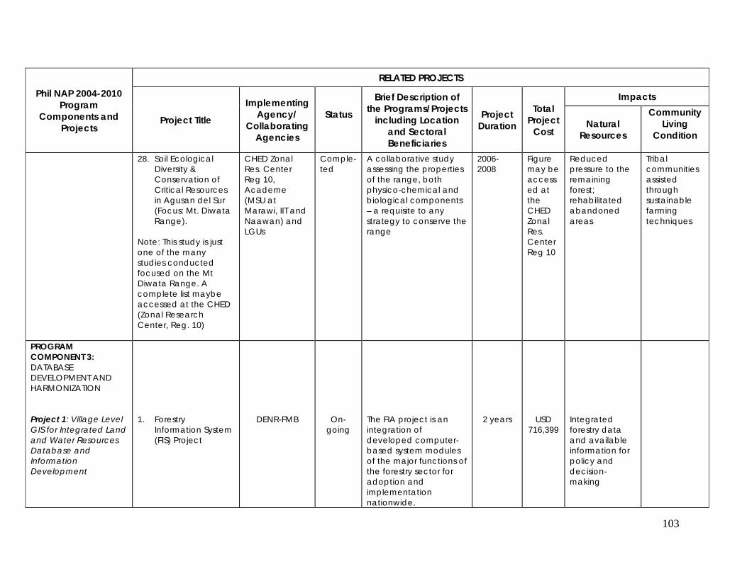
103
Phil NAP 2004-2010 Program
Components and Projects
RELATED PROJECTS
Project Title
Implementing Agency/
Collaborating Agencies
Status
Brief Description of the Programs/Projects
including Location and Sectoral Beneficiaries
Project Duration
Total Project
Cost
Impacts
Natural Resources
Community Living
Condition
28. Soil Ecological Diversity & Conservation of Critical Resources in Agusan del Sur (Focus: Mt. Diwata Range).
Note: This study is just one of the many studies conducted focused on the Mt Diwata Range. A complete list maybe accessed at the CHED (Zonal Research Center, Reg. 10)
CHED Zonal Res. Center Reg 10, Academe (MSU at Marawi, IIT and Naawan) and LGUs
Comple-ted
A collaborative study assessing the properties of the range, both physico-chemical and biological components – a requisite to any strategy to conserve the range
2006-2008
Figure may be accessed at the CHED Zonal Res. Center Reg 10
Reduced pressure to the remaining forest; rehabilitated abandoned areas
Tribal communities assisted through sustainable farming techniques
PROGRAM COMPONENT 3: DATABASE DEVELOPMENT AND HARMONIZATION Project 1: Village Level GIS for Integrated Land and Water Resources Database and Information Development
1. Forestry
Information System (FIS) Project
DENR-FMB
On-going
The FIA project is an integration of developed computer-based system modules of the major functions of the forestry sector for adoption and implementation nationwide.
2 years
USD 716,399
Integrated forestry data and available information for policy and decision-making
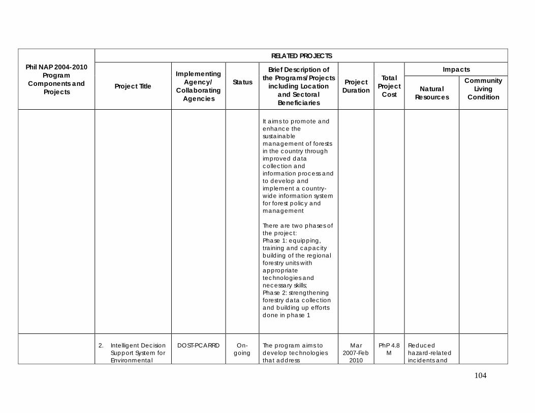
104
Phil NAP 2004-2010 Program
Components and Projects
RELATED PROJECTS
Project Title
Implementing Agency/
Collaborating Agencies
Status
Brief Description of the Programs/Projects
including Location and Sectoral Beneficiaries
Project Duration
Total Project
Cost
Impacts
Natural Resources
Community Living
Condition
It aims to promote and enhance the sustainable management of forests in the country through improved data collection and information process and to develop and implement a country-wide information system for forest policy and management There are two phases of the project: Phase 1: equipping, training and capacity building of the regional forestry units with appropriate technologies and necessary skills; Phase 2: strengthening forestry data collection and building up efforts done in phase 1
2. Intelligent Decision
Support System for Environmental
DOST-PCARRD
On-
going
The program aims to develop technologies that address
Mar
2007-Feb 2010
PhP 4.8
M
Reduced hazard-related incidents and
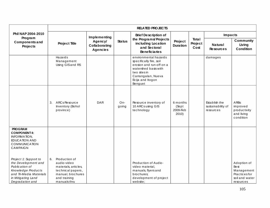
105
Phil NAP 2004-2010 Program
Components and Projects
RELATED PROJECTS
Project Title
Implementing Agency/
Collaborating Agencies
Status
Brief Description of the Programs/Projects
including Location and Sectoral Beneficiaries
Project Duration
Total Project
Cost
Impacts
Natural Resources
Community Living
Condition
Hazards Management Using GIS and RS
environmental hazards specifically fire, soil erosion and run-off on a watershed basis with two sites in Carrangalan, Nueva Ecija and Itogon Benguet
damages
3. ARCs Resource Inventory (Bohol province)
DAR
On-going
Resource inventory of 10 ARCs using GIS technology
6 months (Sept
2009-Feb 2010)
Establish the sustainability of resources
ARBs improved productivity and living condition
PROGRAM COMPONENT 4: INFORMATION, EDUCATION AND COMMUNICATION CAMPAIGN Project 1: Support to the Development and Publication of Knowledge Products and Tri-Media Materials in Mitigating Land Degradation and
6. Production of
audio-video materials, articles, technical papers , manual, brochures and training manuals thru
Production of Audio-video material, manuals, flyers and brochures; development of project website;
Adoption of Best Management Practices for soil and water resources
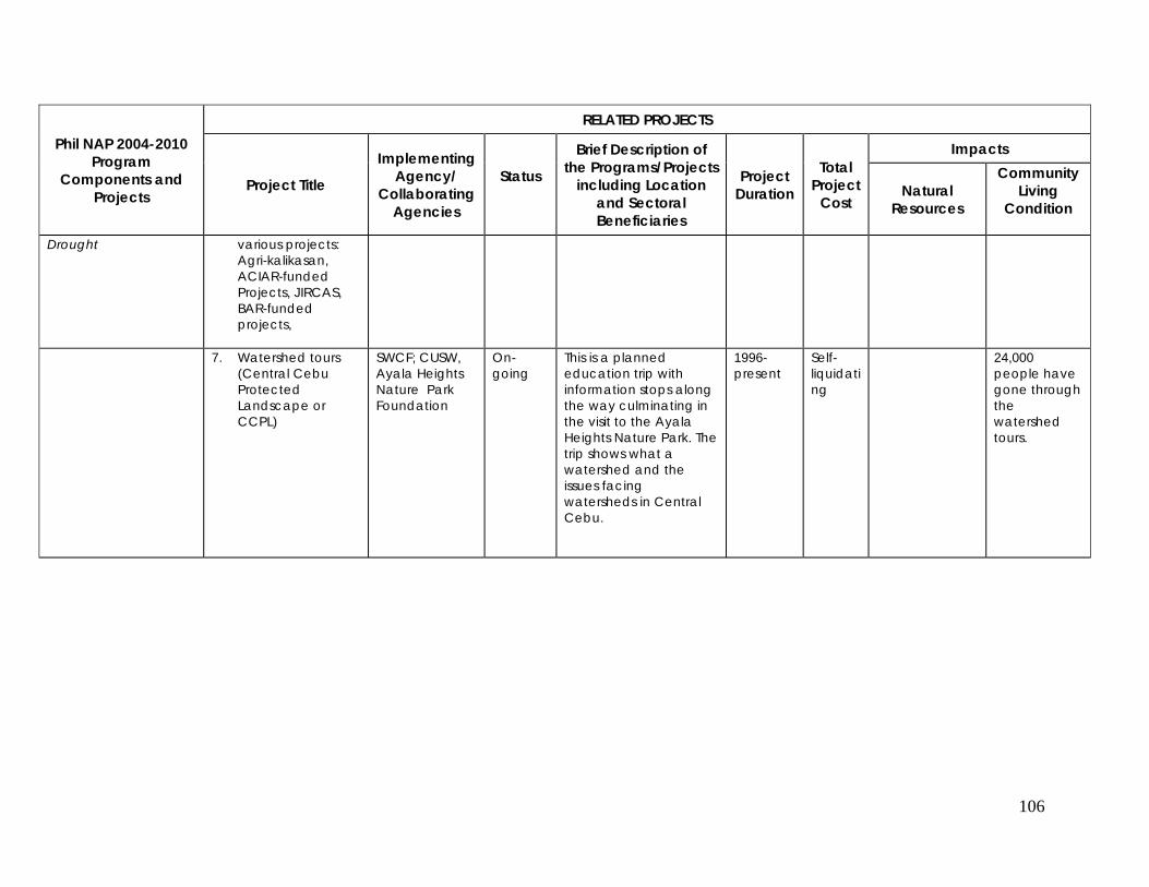
106
Phil NAP 2004-2010 Program
Components and Projects
RELATED PROJECTS
Project Title
Implementing Agency/
Collaborating Agencies
Status
Brief Description of the Programs/Projects
including Location and Sectoral Beneficiaries
Project Duration
Total Project
Cost
Impacts
Natural Resources
Community Living
Condition
Drought various projects: Agri-kalikasan, ACIAR-funded Projects, JIRCAS, BAR-funded projects,
7. Watershed tours
(Central Cebu Protected Landscape or CCPL)
SWCF; CUSW, Ayala Heights Nature Park Foundation
On-going
This is a planned education trip with information stops along the way culminating in the visit to the Ayala Heights Nature Park. The trip shows what a watershed and the issues facing watersheds in Central Cebu.
1996-present
Self-liquidating
24,000 people have gone through the watershed tours.
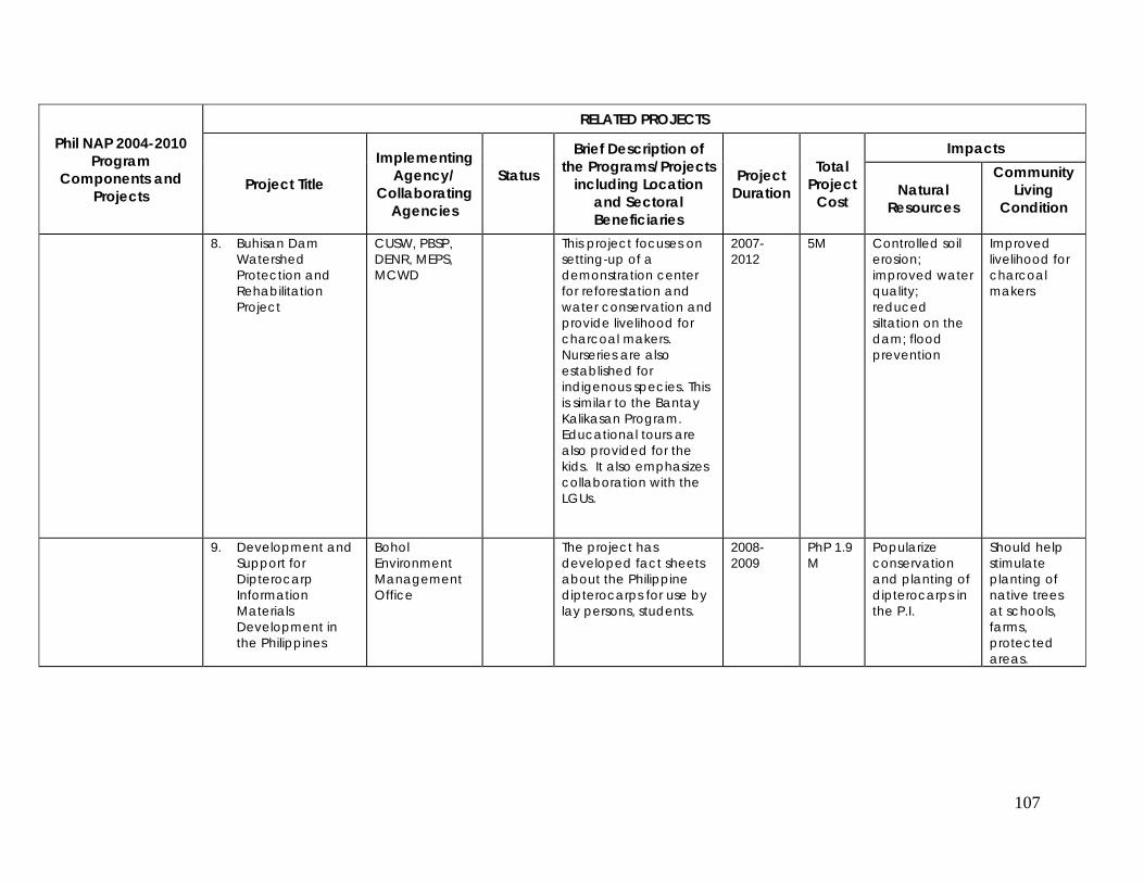
107
Phil NAP 2004-2010 Program
Components and Projects
RELATED PROJECTS
Project Title
Implementing Agency/
Collaborating Agencies
Status
Brief Description of the Programs/Projects
including Location and Sectoral Beneficiaries
Project Duration
Total Project
Cost
Impacts
Natural Resources
Community Living
Condition
8. Buhisan Dam Watershed Protection and Rehabilitation Project
CUSW, PBSP, DENR, MEPS, MCWD
This project focuses on setting-up of a demonstration center for reforestation and water conservation and provide livelihood for charcoal makers. Nurseries are also established for indigenous species. This is similar to the Bantay Kalikasan Program. Educational tours are also provided for the kids. It also emphasizes collaboration with the LGUs.
2007-2012
5M Controlled soil erosion; improved water quality; reduced siltation on the dam; flood prevention
Improved livelihood for charcoal makers
9. Development and Support for Dipterocarp Information Materials Development in the Philippines
Bohol Environment Management Office
The project has developed fact sheets about the Philippine dipterocarps for use by lay persons, students.
2008-2009
PhP 1.9 M
Popularize conservation and planting of dipterocarps in the P.I.
Should help stimulate planting of native trees at schools, farms, protected areas.
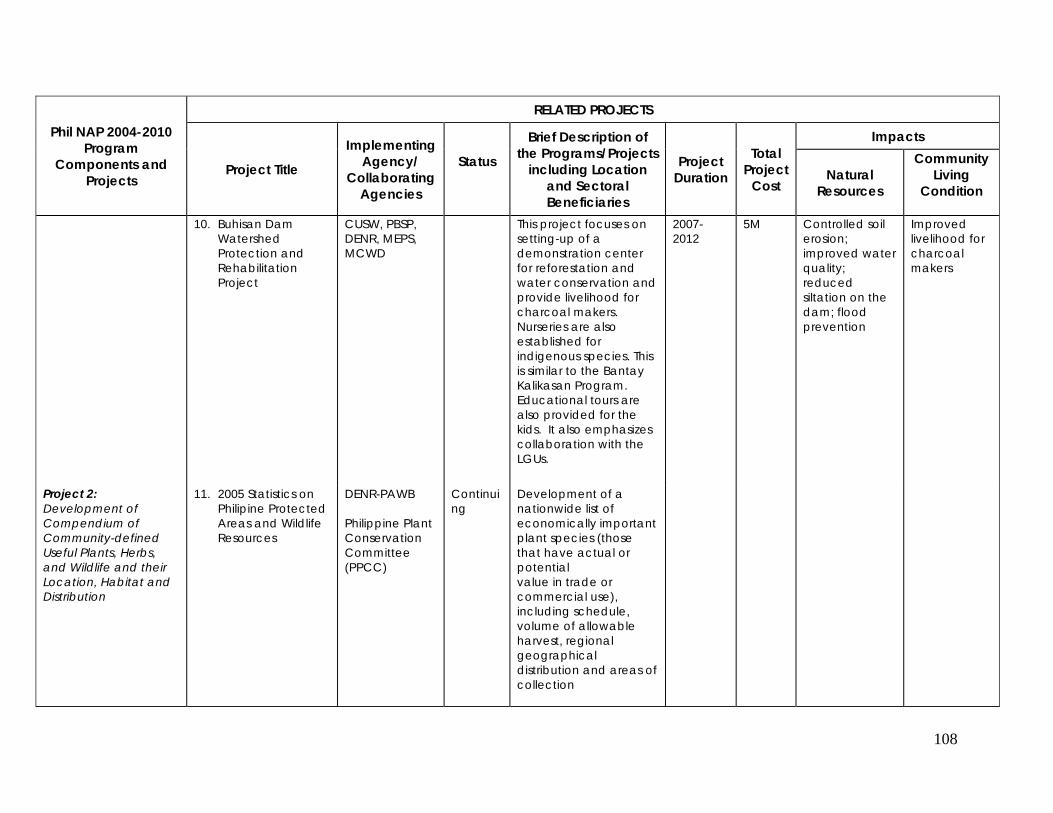
108
Phil NAP 2004-2010 Program
Components and Projects
RELATED PROJECTS
Project Title
Implementing Agency/
Collaborating Agencies
Status
Brief Description of the Programs/Projects
including Location and Sectoral Beneficiaries
Project Duration
Total Project
Cost
Impacts
Natural Resources
Community Living
Condition
10. Buhisan Dam Watershed Protection and Rehabilitation Project
CUSW, PBSP, DENR, MEPS, MCWD
This project focuses on setting-up of a demonstration center for reforestation and water conservation and provide livelihood for charcoal makers. Nurseries are also established for indigenous species. This is similar to the Bantay Kalikasan Program. Educational tours are also provided for the kids. It also emphasizes collaboration with the LGUs.
2007-2012
5M Controlled soil erosion; improved water quality; reduced siltation on the dam; flood prevention
Improved livelihood for charcoal makers
Project 2: Development of Compendium of Community-defined Useful Plants, Herbs, and Wildlife and their Location, Habitat and Distribution
11. 2005 Statistics on Philipine Protected Areas and Wildlife Resources
DENR-PAWB Philippine Plant Conservation Committee (PPCC)
Continuing
Development of a nationwide list of economically important plant species (those that have actual or potential value in trade or commercial use), including schedule, volume of allowable harvest, regional geographical distribution and areas of collection
109
Phil NAP 2004-2010 Program
Components and Projects
RELATED PROJECTS
Project Title
Implementing Agency/
Collaborating Agencies
Status
Brief Description of the Programs/Projects
including Location and Sectoral Beneficiaries
Project Duration
Total Project
Cost
Impacts
Natural Resources
Community Living
Condition
PROGRAM COMPONENT 5: ENABLING POLICY DEVELOPMENT Project 1:Raw Water Valuation, Trading and Incentives for Water Systems
No relevant projects

110
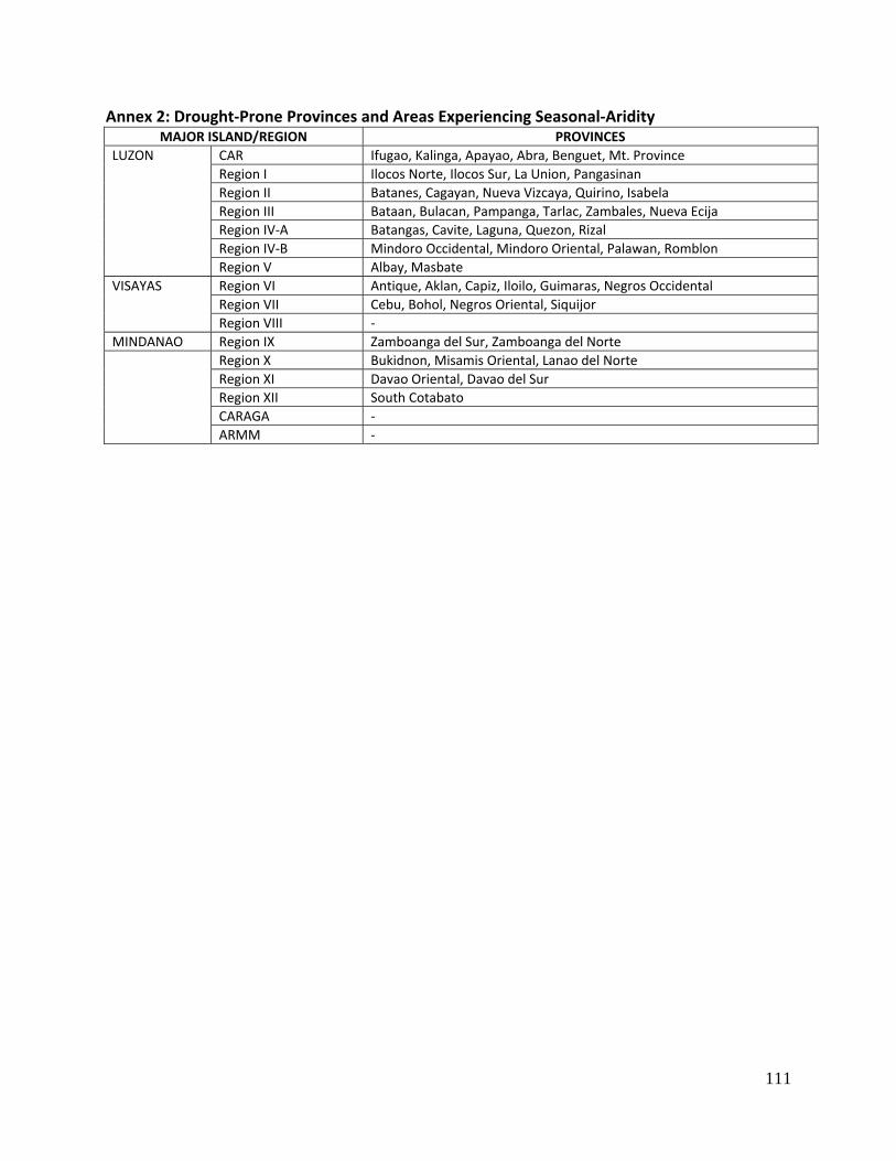
111
Annex 2: Drought‐Prone Provinces and Areas Experiencing Seasonal‐Aridity MAJOR ISLAND/REGION PROVINCES
LUZON CAR Ifugao, Kalinga, Apayao, Abra, Benguet, Mt. Province Region I Ilocos Norte, Ilocos Sur, La Union, Pangasinan Region II Batanes, Cagayan, Nueva Vizcaya, Quirino, Isabela Region III Bataan, Bulacan, Pampanga, Tarlac, Zambales, Nueva Ecija Region IV‐A Batangas, Cavite, Laguna, Quezon, RizalRegion IV‐B Mindoro Occidental, Mindoro Oriental, Palawan, Romblon Region V Albay, Masbate
VISAYAS Region VI Antique, Aklan, Capiz, Iloilo, Guimaras, Negros Occidental Region VII Cebu, Bohol, Negros Oriental, SiquijorRegion VIII ‐
MINDANAO Region IX Zamboanga del Sur, Zamboanga del Norte Region X Bukidnon, Misamis Oriental, Lanao del Norte
Region XI Davao Oriental, Davao del SurRegion XII South CotabatoCARAGA ‐ARMM ‐
112
Annex 3: Relevant Laws, Legislations and Policies Addressing the Underlying Factors Causing Massive Land Degradation in the Philippines
• Agriculture and Fisheries Modernization Act (AFMA) or the Republic Act 8435
This law provides the delineation of the Strategic Agriculture and Fisheries Development Zones (SAFDZ) within the Network of Protected Areas for Agriculture and Agro‐industrial Development (NPAAAD) to ensure that lands are efficiently utilized for food and non‐food production, and agro‐industrialization. The SAFDZ considers production, processing, investment, marketing, human resources, and environmental protection. These activities are undertaken through participatory planning by the Department of Agriculture in consultation with various government agencies, local government, farmers and fishing organizations, the private sector and communities. Some SAFDZ lands are considered non‐negotiable for conversion‐‐‐irrigated lands, irrigable lands already covered by irrigation projects with firm funding commitments, and lands with existing or a potential for growing high value crops.
• The Local Government Code of 1991, Republic Act 7160
It provides that the Local Government Units, shall in conformity with existing laws, continue to prepare their respective comprehensive land use plans and enacted through zoning ordinances which shall be the primary and dominant bases for the future use of land resources.
• National Integrated Protected Areas System or Republic Act 7586
It recognizes the critical importance of protecting and maintaining the natural biological and
physical diversities of the environment notably on areas with biological unique features to sustain human life and development, as well as plant and animal life. In this regard, the State adopts the policy to establish a comprehensive system of integrated protected areas within the classification of national park as provided for by the Constitution for the purpose of securing perpetual existence of all native plants and animals for the present and future generations.
• Comprehensive Agrarian Reform Law or Republic Act 6657
This law recognized that the welfare of the landless farmers and farm workers should receive the highest consideration to promote social justice and to move the nation toward sound rural development and industrialization, and the establishment of owner cultivatorship of economic‐sized farms as the basis of the Philippine agriculture. It also provides a more equitable distribution and ownership of land, with due regard to the rights of landowners to just compensation and to the ecological needs of the nation, which will be undertaken to provide farmers and farm workers with the opportunity to enhance their dignity and improve the quality of their lives through greater productivity of agricultural lands.
• CARPer Law or Republic Act 9700 This is an act strengthening the Comprehensive Agrarian Reform Program (CARP), extending the acquisition and distribution of all agricultural lands, instituting necessary reforms, amending for the
113
purpose certain provisions of Republic Act No. 6657, otherwise known as the Comprehensive Agrarian Reform Law of 1988. It states that the DAR, in coordination with the Presidential Agrarian Reform Council (PARC) shall plan and program the final acquisition and distribution of all remaining unacquired and undistributed agricultural lands from its date of effectivity (July 27,2009) until June 30, 2014.
• Indigenous People’s Rights Act or Republic Act 8371
It provides that the rights of indigenous cultural communities/indigenous people (ICCs/IPs) to their
ancestral domain to ensure their economic, social and cultural well being shall be protected and the applicability of customary laws governing property rights or relations in determining ownership and extent of ancestral domain shall be recognized by the State. Specifically, the ICCs/IPs shall have the right to develop, control and use lands and territories traditionally occupied, owned or used; to manage and conserve natural resources within the territories; benefit and share the profits from allocation and utilization of the natural resources found therein; and negotiate the terms and conditions for the exploration of natural resources among others.
• Department of Energy Act or Republic Act 7638
The State shall provide a continuous, adequate and economic supply of energy with the end in view
of ultimately achieving self‐reliance in the country’s energy requirements through the integrated and intensive exploration, production, management and development of the country’s growth and economic development and taking into consideration and active participation of the private sector in the various areas of energy resource developments.
• Special Economic Zone Act or Republic Act 7916
The State shall actively encourage, promote, induce and accelerate a sound and balanced industrial,
economic and social development of the country in order to provide jobs to the people especially those in the rural areas, increase their productivity and their individual and family income, and thereby improve the level of the quality of their living conditions through the establishment of the special economic zones in suitable and strategic locations in the country and through measures that shall effectively attract legitimate and productive foreign investment.
• Urban Development and Housing Act or Republic Act 7279
This law provides for the rational use and development of urban land to bring about: 1) equitable
utilization of residential lands in urban and urbanizable areas; 2) optimization of the use and productivity of land and urban resources; 3) development of urban areas conducive to commercial and industrial activities; 4) reduction in urban dysfunction, particularly those that adversely affect public health, safety and ecology; and 5) access to land and housing by the unprivileged and homeless citizens.
• Climate Change Act of 2009 or Republic Act 9729
This is an act mainstreaming climate change into government policy formulations, establishing the framework strategy and program on climate change, creating for this purpose the Climate Change
114
Commission and for other purposes. The State adopts the principle of protecting the climate system for the benefit of humankind, on the basis of climate justice or common but differentiated responsibilities and the Precautionary Principle to guide decision‐making in climate risk management.
• Revised Forestry Code of the Philippines or Presidential Decree 705
It states that the multiple uses of forestlands shall be oriented to the development and progress requirements of the country, the advancement of science and technology and the public welfare. The protection, development and rehabilitation of forestlands shall be emphasized so as to ensure their continuity in productive condition.
This PD includes the following:
1. Proper classification, management and utilization of the lands of the public domain to maximize their productivity to meet the demands of our increasing population is urgently needed;
2. Reassessment of the multiple uses of the forest lands and resources before allowing any utilization thereof to optimize the benefits that can be derived therefrom;
3. Emphasis not only on the utilization thereof but more so on the protection, rehabilitation and development of forest lands, in order to ensure the continuity of their productive condition;
4. The present laws and regulations governing forest lands are not responsive enough to support reoriented government programs, project and efforts on the proper classifications and delimitation of the lands of the public domain, and the management, utilization, protection, rehabilitation, and development of forest lands;
5. Adoption of the following policies:
a) The multiple uses of forest lands shall be oriented to the development and progress requirements of the country, the advancement of science and technology and the public welfare;
b) Land classification and survey shall be systematized and hastened; c) The establishment of wood‐processing plants shall be encouraged and rationalized; and d) The protection development and rehabilitation of forest lands shall be emphasized so as
to ensure their continuity in productive condition.
• The Environmental Impact Assessment System or Presidential Decree 1586
It provides the establishment and institutionalization of a system whereby the exigencies of the socio‐economic undertakings can be reconciled with the requirements of environmental quality. It paved the way for the declaration of certain projects, undertakings or areas in the country as environmentally critical requiring them to prepare and submit proper land and water use pattern for the areas of said critical projects shall be prepared.
• The Balanced Fertilization Strategy (BFS), Presidential Proclamation 1071
115
It gives emphasis on management of crop residues, farm water recycling and an optimum combination of organic and inorganic fertilizers. This strategy was established by BSWM due to massive use of inorganic fertilizers resulting to soil acidity and low soil productivity.
• Water Code of the Philippines
The 1976 National Water Code establishes the basic principles and framework related to the ownership, appropriation, utilization, exploitation, development, control, conservation and protection of water resources to achieve the optimum development and rational utilization of the water resource. The Code is basically governed by the following principles:
a. All waters belong to the State. b. All waters that belong to the State cannot be the subject to acquisitive prescription. c. The State may allow the use or development of waters by administrative concession. d. The utilization, exploitation, development, conservation and protection of water
resources shall be subject to the control and regulation of the government through the National Water Resources Council, hereinafter referred to as the Council.
e. Preference in the use and development of waters shall consider current usages and be responsive to the changing needs of the country.
• Clean Water Act of the Philippines
Republic Act (RA) No. 9275 (Philippine Clean Water Act of 2004) provided for the comprehensive
water quality management in the country. The Act declares the following policies with respect to water quality management as part of the framework for sustainable development:
a. Promote environmental strategies, use of appropriate economic instruments and of control
mechanisms for the protection of water resources; b. Formulate a holistic national program of water quality management that recognizes that
water quality management issues cannot be separated from concerns about water sources and ecological protection, water supply, public health and quality of life;
c. Formulate an integrated water quality management framework through proper delegation and effective coordination of functions and activities;
d. Promote commercial and industrial processes and products that are environment friendly and energy efficient;
e. Provide for a comprehensive management program for water pollution focusing on pollution prevention;
f. Promote public information and education and to encourage the participation of an informed and active public in water quality management and monitoring;
g. Formulate and enforce a system of accountability for short‐ and long‐term adverse environmental impact of a project, program or activity; and
h. Encourage civil society and other sectors, particularly labor, the academe and businesses to organize, educate and motivate the people in addressing pertinent environmental issues and problems at the local and national levels.
• Medium‐Term Philippine Development Plan (MTPDP) 2004‐2010
The MTPDP is an overarching policy for the conservation and improvement of water supply for both agricultural and industrial uses in the country. This will contribute to NAP’s call for
116
sustainable water resource for agricultural production. It enumerates the following specific strategies for the water supply, sewerage, and sanitation (WSSS): a. Pursue the provision of potable water to the entire country by 2010 through public and
private investment, with focus given to areas with poor water supply coverage; b. Ensure that all barangays/municipalities that will be provided with water supply services have
the corresponding sanitation facilities for proper disposal of wastewater/septage; c. Continue provision of capacity building programs and technical assistance on WSSS planning,
management and project implementation for all water service providers; d. Develop technology options for water supply (e.g. solar desalination for isolated islands,
windmill technology, etc.); e. Complete the groundwater resource inventory/assessment in major urban areas and surface
water in rural areas, control extraction through moratorium/stringent requirements in the grant of water permits in water‐deficient areas and complete registration of all water pumps, metering of water pumps, etc.; and
f. Improve water quality through close and regular monitoring of 18 priority rivers nationwide.
• National Land Use Bill
The legislation intends to guide the optimum allocation of land among competing uses within the framework of sustainable development. It shall also provide a mechanism for resolving land use policy conflicts taking into consideration the principles of social equity and economic efficiency. The draft NLUA may serve as the overarching policy approach to address land degradation by influencing the typology of land uses and activities consistent with sustainable development and environmental conservation principles. During the 39th NLUC meeting last 11 December 2008, the members agreed to use the NLUC version of the NLUA as basis for drafting the member’s position. This bill is pending in the Special Committee on Land Use.
• Office of the President Administrative Order 226 as amended by 226‐A series of 2008 on
suspending the processing and approval of all land conversion applications of all rice lands This administrative order aims to promote food security by imposing a two (2) year ban in the
conversion of rice lands to non‐agricultural uses. While the AO 226 is directed more towards ensuring food availability through the protection of rice lands, the policy is consistent with the NAP recommendations which call for the formulation and implementation of land use policies that promote the efficient and proper utilization of land resource.
• Executive Order 807 Series of 2009 repealing Letter of Instruction (LOI) No. 58 of 1973
The said EO lifted the restrictions on the area that can be planted for export‐quality bananas nationwide pegged by LOI No. 58 at 26,250 ha which would encourage expansion of existing commercial production areas. Given the heavy application of inorganic production inputs in banana plantations, the NAP should identify plantation‐specific interventions (e.g. technology, soil management practices, etc.) that would sustain/improve the productivity of the soil.
• Executive Order 774 Series of 2008 on Reorganizing the Presidential Task Force on Climate
Change.
117
This EO supports the production of food crops in a sustainable manner and mandates the limited
use or non‐use of chemical pollutants. Section 3 and 4 also mandates the identification, regeneration, and protection of forest lands, water resources, watersheds, and other protected areas in the Philippines. The EO contributes to the protection of land quality through the limited use or non‐use of chemical pollutants as well as continuous protection of forest lands and watersheds.
• Executive Order 481 Series of 2005 on Promotion and Development of Organic Agriculture in
the Philippines. One of its main objectives is to guarantee food and environmental safety by means of an ecological approach to farming, especially the limited or non‐use of chemical fertilizers. This is being implemented under the leadership of the Department of Agriculture. The EO will contribute to the preservation of soil quality and mitigate the possible impact of chemicals to decreasing soil quality.
• National Program for Sustainable Upland Farming through the establishment of “Barangay
Sagip Saka” (Conservation Farming Village).
The program aims to help upland farmers improve their economic conditions by strengthening their capacity to manage natural resources through the practice and promotion of conservation farming (CF) technologies, among them hedgerow farming, alley cropping, bench terracing, minimum tillage, natural vegetative strips, sloping agricultural land technology, and agroforestry. This is being implemented under the leadership of DOST‐PCARRD. The program will contribute to the continuous improvement of soil fertility and land quality.
• Senate Bill 3038: Private Land Forestry and Incentive Act of 1999
The bill aims to institutionalize private land forestry to enhance reforestation and environment protection and providing incentives, thereof. All land areas covered by the integrated social forestry program of DENR classified as special agricultural lands, declared as “Permanent Agro‐Forestry Zones. As special agricultural lands, the area shall continue to be farmed with at least 20% of the land planted to the trees or reforestation species and with environmental protection measures.
• Senate Bill 3131: Water Use Efficiency and Conservation Research Act of 2009
The bill aims to provide research, development, education and technology transfer activities related to water use efficiency and conservation technologies and practices. Pending in the Committee (4/13/2009).
• Senate Bill 3296: Waterless Technology Act of 2009
This bill aims to establish a comprehensive program for the promotion of waterless technologies to conserve precious water resources, providing enabling mechanisms for technology transfer. It is under the purview of State’s policy to protect, conserve and sustain our water resources and
118
that the State shall promote the efficient use of water resources and adopt waterless technologies. Pending in the Committee (6/2/2009).
• Senate Bill 3264: Organic Agriculture Act of 2009
The bill aims to provide for the development of organic agriculture in the Philippines. It is under the State’s policy to promote, propagate, develop further, and implement the practice of organic agriculture in the Philippines that will cumulatively condition and enrich the fertility of the soil, increase farm productivity, reduce pollution and destruction of the environment, prevent depletion of natural resources, protect the health of farmers, consumers and general public, and save on imported farm inputs. Pending Second reading, special order (5/26/2009).
• Irrigation Management Transfer (IMT)
IMT is the standing policy and program strategy of the National Irrigation Administration (NIA) which aims to transfer the operation and management of irrigation systems to the irrigators’ associations (IAs). The IMT process seeks out to develop and strengthen the IAs to make them capable of recognizing their innate capacity and mobilizing their members to take on the challenge of managing irrigation system with confidence and sincere commitment through informed collective decisions of all members. The process looks at the progressive development of the IAs, individually and as a group of water users served and linked together by a common source or supply.
• National Water Resources Policy The formulation of a national water resources policy, which is headed by National Water Resources Board (NWRB), was identified as one of the priority programs under the PWSSR. It aims to consolidate and harmonize existing policies which will set the goals and objectives for the management of water resources at the national scale and includes policies for regions, catchments, shared or transboundary water resources, and inter‐basin transfers, all within an Integrated Water Resources Management (IWRM) framework.
• Raw Water Pricing (Pilot Stage)
Recognizing that water is not a free resource, the study was conducted to improve supervision and environmentally sound management of raw water resources starting in two pilot sites. It involved: (i) a methodical review and selection of a tariff alternative for raw water pricing; (ii) support in the restructuring of NWRB into a regulatory body; (iii) testing and introduction of a raw water tariff in two pilot sites; and (iv) provision of assistance in instituting raw water pricing. Success of introducing raw water pricing is still undetermined to date as the piloting is still ongoing.
119
• Participatory Irrigation Development Project (PIDP) (recently ICC approved project) PIDP is a sector‐wide reform program of the government for irrigation management and
development in the Philippines. It basically aims to support the goal of government to achieve sustainable growth of the rural sector through agricultural modernization and competitiveness of agri‐based enterprises. One of the major activities under the project is the formulation of an IMT policy framework which will serve as a guide to policy‐makers, supervisors and implementers at the NIA Central, Regional and field levels, including participating IAs and other stakeholders towards a successful IMT implementation and sustenance by program players.
120
Glossary of Terms Agroforestry – it is a flexible agricultural system approach to manage the agricultural resource, land, for the benefits of the farmers, and the long‐term welfare of society; an integration of trees, plants, and animals in conservative, long‐term, productive systems appropriate for all lands especially in the hillside and uplands. Arid, semi‐arid and dry sub‐humid areas ‐ Areas, other than polar and sub‐polar regions, in which the ratio of annual precipitation to potential evapotranspiration falls within the range from 0.05 to 0.65. Benchmarks and Indicators – scientific data used for monitoring the status of desertification and assisting the Conference of the Parties in evaluating or assessing the effectiveness of national efforts to implement the Convention. Biodiversity – refers to all species of plants, animals and micro‐organisms existing and interacting within an ecosystem. Capability Building – is an important driving force for involving local stakeholders in the local area development initiatives and enhancing the sustainability of the people’s livelihood such as implementing sustainable activities, agroforestry, water resources management, etc. monitor and evaluate impacts of their activities as to which will give equitable and multiple benefits to the local community and the environment. Combating Desertification – includes activities which are part of the integrated development of land in arid, semi‐arid, and dry sub‐humid areas for sustainable development which aimed at: (i) prevention and/or reduction of land degradation; (2) rehabilitation of partly degraded land; and (iii) reclamation of desertified land. Desertification - Land degradation in arid, semi-arid and dry sub-humid areas resulting from various factors, including climatic variations and human activities.
Documents ‐ Official meeting documents are placed on the website, as they become available. In‐session documents are distributed on site and may include CRPs, and non‐papers. Informal documents are often distributed outside the meeting room by Parties or observers.
Drought ‐The naturally occurring phenomenon that exists when precipitation has been significantly below normal recorded levels, causing serious hydrological imbalances that adversely affect land resource production systems.
El Niño – a large scale oceanographic/meteorological phenomenon, manifested through a local warming of surface waters in the entire equatorial zone of the central and eastern Pacific Ocean. Minor El Niño happens every 2‐3 years, and the major ones every 8‐11 years. Recently, scientists reported that El Niño has a return period of 4‐5 years, with a lasting period of 12‐18 months.
121
Focal Point ‐ A representative from each country serves as the focal point for the Convention to liaise with the Secretariat and to assist in inter‐sessional work. Focal points are to be distinguished from the officially accredited Head of Delegation to the COP.
Global Environment Facility (GEF) ‐ The Global Environment Facility was established by the World Bank, the United Nations Development Programme (UNDP) and the United Nations Environmental Programme (UNEP) in 1990. It operates as the Climate Change (UNFCCC) and Biodiversity (UNCBD) Conventions’ financial mechanism. The GEF was created to provide grants and concessional funds to developing countries to finance incremental costs for programmes, projects, and activities to protect the world's environment. Anti‐desertification projects relevant to the focal areas of climate change, biodiversity, ozone depletion, and international waters may be eligible for funding.
Global Mechanism (GM) ‐ Established under the Convention, the GM is in charge of promoting actions for the mobilization and channeling of substantial financial resources, including the transfer of technology, on a grant basis, and/or on concessional or other terms, to affected developing country Parties. The Global Mechanism is hosted in Rome by the International Fund for Agricultural Development (IFAD), and functions under the authority and guidance of the Conference of the Parties. Hotspots area – regions or areas identified most vulnerable to drought and suffer most from extended dry spell brought by El Niño episodes, experiencing seasonal aridity and massive land degradation. Integrated Watershed Management – the process of formulating and implementing a course of action involving natural, introduced and human resources of a watershed, taking into account the social, economic and institutional factors operating within the watershed and the surrounding and other relevant regions to achieve specific objectives. Karst ‐ is a term that was first applied to a plateau in the Dinaric Alps of Yugoslavia. Areas that are characterized by the presence of limestone or other soluble rocks, where drainage has been largely diverted into subterranean routes, the topography of such areas is dominated by sinkholes, sinking streams, large springs, and caves. Land – the terrestrial bio‐productive system that comprises soil, vegetation, other biota, and, the ecological and hydrological processes that operate within the system. Land Degradation – a temporary or permanent decline in the productive capacity of the land (UN/FAO definition); reduction or loss in arid, semi‐arid, and dry sub‐humid areas of the biological or economic productivity and complexity of rainfed cropland, irrigated cropland, or range, pasture, forest and woodlands resulting from land use or from a process or combination of processes, including processes arising from human activities and habitation pattern, such as: (i) soil erosion caused by wind and/or water; (ii) deterioration of the physical, chemical and biological or economic properties of soil; and (iii) long term loss of natural vegetation (UNCCD definition). Mitigating the effects of drought – activities related to the prediction of drought and intended to reduce the vulnerability of society and natural systems to drought as it relates to combating desertification. National Action Programme (NAP) – National Action Programmes are at the heart of the Convention and constitute the conceptual and legal framework for implementing it at the national and local levels.
122
Their purpose is to identify the factors contributing to desertification and the practical measures necessary to combat desertification and mitigate the effects of drought. The Convention indicates that affected countries shall elaborate and implement them with the full participation of local communities and all interested stakeholders. The Programme should be fully integrated with other development programmes. Participatory Planning and Evaluation – the opposite of participatory rural appraisal, the local stakeholders and external collaborators are required to play and pro‐active on the equal footing in observing the ecological characteristics and socio‐economic conditions in a particular community and planning suitable activities for promoting sustainable natural resource management and community development. Philippine National Action Plan – is an expression of full and unqualified commitment of the Philippine Government in the effective and accelerated implementation of the programs and project activities to combat desertification, land degradation and poverty in the identified drought vulnerable areas of the country. This is also the working document for the convergence of actions of the Departments of Agriculture (DA), Environment and Natural Resources (DENR), Science and Technology (DOST) and Agrarian Reform (DAR). Ratification ‐ After signing a treaty, a country must ratify it, often with the approval of its parliament or other legislature. Such process implies not only an expression of interest as indicated by the signature, but the transformation of the treaty’s principles and obligations into national law. The instrument of ratification must be deposited with the Depositary, which in the case of the CCD, is the Secretary‐General of the United Nations. The country will become a Party of the Convention by the completion of a period of 90 days after the deposit of the instrument of ratification.
Regional Action Programme (RAP) ‐ Designed through consultation with countries in the region, RAPs can help to harmonize and strengthen national programmes. In the UNCCD context, regions to develop RAPs include Africa, Asia, Latin America and the Caribbean, the Northern Mediterranean, and Central and Eastern Europe.
Regional groups ‐ In the UNCCD context, five regional groups meet privately to discuss issues and nominate Bureau members and other officials. They are Africa, Asia, Eastern Europe, Latin America and the Caribbean (GRULAC), and the Western Europe and Other Group (WEOG).
Republic Act 7160 – The Local Government Code of the Philippines 1991.
Seasonal aridity ‐ refers to seasonal dryness caused by natural drought and El Nino phenomenon.
Secretariat of the UNCCD ‐ The Executive Secretary and his staff are responsible for servicing the COP, including the preparation of documents and meeting arrangements. The CCD Secretariat is institutionally linked to the United Nations.
Soil and Water Conservation – a field of human endeavor included in the concept of watershed management but specifically devoted to the prevention of soil erosion, the preservation of fertility, and the effective use of water resources.
123
Stakeholder – Individuals or institutions (public and private) interested and involved in UNCCD related processes and activities.
Sub‐regional Action Programme (SRAP) ‐ Designed through consultation with countries in the sub‐region, SRAPs can help harmonize and strengthen national action programmes. Examples of sub‐ regions are Western Africa and South Asia. See also Regional Action Programme.
Sustainable Agriculture – refers to the development of technology and practices that maintain and/or enhance the quality of land and water resources; a system which maintains an acceptable and increasing level of productivity that satisfies the prevailing needs and is continuously adapted to meet the future needs for increasing the carrying capacity of the resource base and other human needs.
Sustainable Land Management – is the use of the land to meet changing human needs (agriculture, forestry, conservation), while ensuring long term socio‐economic and ecological functions of the land.
Sustainable Development – Development policies that meet the needs of the present without compromising the ability of future generations to meet their own.
Thematic Programme Network (TPN) / Regional Cooperation Networks (RCN)‐ Networks established at the regional level by affected country Parties to address specific themes of relevance in the framework of the UNCCD implementation. In particular, the Asian region is working on six TPNs (the following have been launched: TPN for desertification monitoring and assessment; on agro‐forestry and soil conservation; on pasture management and sand dune fixation; on Water resources management for agriculture in arid, semi‐arid and dry sub‐humid areas), the African region is also working on six TPNs (Networks for the integrated management of international river, lake and hydro‐geological basins; the promotion of agroforestry and soil conservation; the rational use of rangelands and promotion of fodder crops development; the ecological monitoring, natural resources mapping, remote sensing and early warning systems; the promotion of new and renewable energy sources and technologies; and the promotion of sustainable agricultural farming systems). UNCED ‐ The United Nations Conference on Environment and Development, also known as the Rio Earth Summit held in Rio de Janeiro in 1992. It promoted a new, integrated approach to the problem of desertification emphasizing action to promote sustainable development. It recommended that the United Nations General Assembly establish an Intergovernmental Negotiating Committee to prepare, by June 1994, a United Nations Convention to Combat Desertification. Water Resources – refers specifically to the quality and quantity of water produced naturally as one of the earth’s major resources. Watershed – a topographically delineated area of land from the which the rainwater can drain, as surface run‐off via a specific stream or river system to a common outlet point with may be a dam, irrigation system or urban water supply take‐off point, or where the stream discharges into river, lake or sea. Watershed Management – the process of guiding and organizing land and other resources uses in a watershed to provide desired goods and services without adversely affecting soil and water resources; the application of business methods and technical principles to the manipulation and control of
124
watershed resources to achieve a desired set of objectives such as maximum supply of usable water, minimization of soil erosion and siltation problems, and reduction of flood and drought occurrences
125
References Publications, Reports, and Presentations BSWM, 1989. Crop Development and Soil Conservation Framework for Mindanao Island. Ser. 1 Vol. 1.
Quezon City. 190 p. BSWM, 1993. Crop Development and Soil Conservation Framework for Visayas Island. Manila. 283 p. BSWM, 1993. Crop Development and Soil Conservation Framework for Luzon Island. Manila. 298 p. CAIT. 2008. "Climate Analysis Indicators Tool (CAIT) Version 5.0." Online. Concepcion, R. N., 2000. State of Land, Water and Plant nutrition Resources: Philippine national report.
Regional Workshop on Land Resources Information System, January 25‐27, 2000. Bureau of Soils and Water Management, Quezon City. 88 p.
DENR, UNDP, ACB, ADMU, 2009. Assessing Progress Towards the 2010 Biodiversity Target: The 4th
National Report to the Convention on Biological Diversity. De Guzman, R. G., undated. Impacts of Drought in the Philippines. A paper presented at the
International Workshop on Drought and Extreme Temperatures: Preparedness and Management for Sustainable Agriculture, Forestry.
EMB, 2007. National Water Quality Status Report 2001‐2005. EMB 1999. The Philippines’ Initial communication on Climate Change. FMB, 2003. Philippine Forestry Statistics Global Facility for Disaster Risk Reduction (GFDRR), 2008. South‐South Cooperation for Disaster Risk
Reduction Call for Proposals. Guiang, E.S., 2004. Annex E ‐ Environmental Analysis USAID/Philippines Strategy for 2005‐2009,
Development Alternative Inc. ICCD/COP 8/16/Add 1. Report of the UNCCD Conference of Parties on Eight Session held in Madrid from
3 to 14 September, 2007 Addendum. Jegillos, S.R, de Guzman, M., Jose, A.M., Perez, R.T., Carpio, F., Mallari, E., Pavia, T.V., undated.
Philippines Country Case Study: Impacts and Responses to the 1997‐1998 El Nino event, Asia Pacific Disaster Management Center. Makati City, Metro Manila, Philippines
Lasco, R. D., K. L. Villegas, P. A. Jaranilla‐Sanchez and G. B. Villamor. 2006. Climate Change R&D at the
World Agroforestry Center (ICRAF)‐ Philippines. ASEAN‐JAPAN project on Multifunctionality of Agriculture and the 3 UN Conventions on Biodiversity, Climate Change and Land Degradation, Cebu City.
126
National Land Use Committee. 2002. National Framework for Physical Planning 2001‐2030. National Economic and Development Authority. Philippines. 347 p.
NWRB, 2006. The Integrated Water Resources Management (IWRM) Plan Framework. NSCB, 2006. Compendium of Philippine Environment Statistics. NSCB 2003. State of the Philippines Land and Soil Resources. PAWB, 2005. Statistics on Philippine Protected Areas and Wildlife Resources. PCARRD‐DOST‐DENR‐FMB‐DA‐UPLB‐CNFR‐FDC/ENFOR. 1999. Guidelines for watershed management
and development in the Philippines. Los Baños, Laguna: PCARRD‐DOST‐DENR‐FMB‐DA‐UPLB‐CNFR‐FDC/ENFOR. 241 p.
Perez, R. T. undated. "Assessment of vulnerability and adaptation to climate change in the Philippines
coastal resources sector". Online. September 3, 2009. Available at: http://www.survas.mdx.ac.uk/pdfs/3perez.pdf.
PCARRD, 2001. El Niño Southern Oscillation: Mitigating Measures. Los Baños, Laguna: PCARRD. 296 p. Reijntjes, C.B., Havercort and A. Waters‐Bayer.1992. Farming for the future. MacMillan Press Ltd.,
London. UNDP, 2003. Country Level Impact Assessment (CLIA): The Philippines. United Nations Development
Programme Evaluation Office, One United Nations Plaza, New York, NY 10017, USA. Rincón, MF.G., and Virtucio, F.K., 2008. Climate Change in the Philippines: A Contribution to the Country
Environmental Analysis – A discussion paper . World Bank. Kovats, R.S., Bouma, M.J.,and Haines, A., 1999. El Niño and Health. World Health Organization, Geneva. World Bank, 2003. Philippines’ Environment Monitor 2003: Water Quality. 1818 H. Street, N.W.
Washington, D.C. 20433 U.S.A. WRI, 2008. Climate Analysis Indicators Tool (CAIt) Version 5.0. Washington DC.
127
Web Sources
http://www.adb.org http://www.bas.gov.ph http:// www.essc.org.ph http://www.fao.org http://www.census.gov.ph/data/census2007/index.html http://www.nscb.gov.ph http://www.old.uplb.edu.ph http:/www.pagasa.dost.gov.ph http://www.pcarrd.dost.gov.ph http://www.reefcheckphilippines.org http://www.who.int
128
ACKNOWLEDGMENT
The BSWM, as the UNCCD Focal Point acknowledges and appreciates the significant contributions of the following government agencies, NGOs, SCUs, stakeholders and others who devotedly shared their time and efforts to contribute in the identification of pertinent problems, issues and concerns on land degradation and desertification; and providing substantial comments on the program components of the updated Phil NAP (2010‐2020).
1. Hon. Proceso J. Alcala and Hon. Bernie G. Fondevilla, current and former secretary of the Department of Agriculture (DA) respectively, Hon. Ramon J.P. Paje of the Department of Environment and Natural Resources (DENR), Hon. Virgilio R. delos Reyes of the Department of Agrarian Reform (DAR), and Hon. Mario G. Montejo of the Department of Science and Technology (DOST), for endorsing the NAP to the UNCCD as the official convergence program of the Philippines to combat desertification, land degradation, drought and alleviate poverty incidence in the country side.
2. Representatives from various government agencies (DA‐ATI, DA‐RFUs, DA‐BAR, DA‐BAS, DA‐Planning Service, NIA, PCA, Philrice, DAR‐BLD, DAR‐SSO, DAREMB‐DENR, PAWB‐DENR, FMB‐DENR, FASPO‐DENR, MGB‐DENR, LMB‐DENR, DENR‐Regional Offices, NAMRIA, NWRB, PCARRD‐DOST, PAGASA‐DOST, DOST‐Regional Offices, NEDA, NSCB, LWUA, NAPC, HLURB, DILG, DFA, CHED) for their comments, contributions, and active participation in consultations.
3. Representatives from various Colleges and Universities (Central Luzon State University,
University of the Philippines‐School for Urban and Regional Planning, University of the Philippines Los Baños, Visayas State University, Mindanao State University, Silliman University, University of San Carlos, Xavier University‐Ateneo de Cagayan), who responded to our invitation and shared their knowledge and expertise in identifying DLDD issues, problems, and mitigation measures.
4. Representatives from private and non‐government entities (Philippine Rural Reconstruction
Movement, Cebu Uniting for Sustainable Water Foundation, Soil and Water Conservation Foundation, Landcare Foundation) who provided suggestions and inputs in the content of the program.
5. Representatives from Local Government Units in Luzon, Visayas and Mindanao, who
participated in the consultation‐workshops.
6. Representatives from international organizations (Food and Agriculture Organization, Australian Centre for International Agricultural Research, and United Nations Development Program) for their active participation during the consultations and continued support to the Bureau’s programs and projects
7. Dr. William Dar, former DA Secretary and current ICRISAT Director, Undersecretary Rosalina
L. Bistoyong of DAR, Dr. Candido Cabrido, Dean of the UP School for Urban and Regional
129
Planning, and Dr. Rogelio Concepcion, former BSWM Director, for their valuable insights, comments and suggestions for the improvement and elaboration of the NAP
8. The following BSWM Senior and Junior Staff who devotedly served as Technical Writers of the NAP, conducted research needs assessment, and developed project proposals:
Asst. Director Wilfredo E. Cabezon, Engr. Samuel Contreras, Dr. Lauro Hernandez , Dr. Gina Nilo, Dr. Edna Samar, Ms. Karen Salandanan, Ms. Sharon De Vera, Ms. Jenny Anne Perlado, and Mr. Renel Bernardino
9. The following BSWM Staff who provided support in the facilitation of UNCCD‐NAP‐related activities: Mr. Rodelio Carating, Engr. Arnulfo Gesite, Engr. Teresita Sandoval, Ms. Jovette Tenorio, Ms. Melijoy Peñaranda, Mr. Baldwin Pine, Mr. Andrew Flores, Mr. Irvin Samalca, Ms. Elsie Balagtas, Ms. Aurora Manalang, Ms. Sonia Salguero, Ms. Georgina Carmelle Siena, Ms. Ma. Perpetua Ocampo, Mr. Jose Paolo Suministrado, Mr. Pastor Abellar Jr., Ms. Nicomedes Liu, Ms. Lucilda Songcuya, Ms. Maris Alquisar, and Mr. Adrian Cruz
10. Lastly, appreciation is bestowed to the UNCCD Secretariat and the DENR‐BSWM STREEM Project for the organizational funds provided for this endeavor