Embed Size (px)
Citation preview

Photo Interpretation of the Terrain along
V »
the Southern Part of the Alaska HighwayBy HUGH M. RAUP and CHARLES S. DENNY
MINERAL RESOURCES OF ALASKA,. 1945-46
GEOLOGICAL SURVEY BULLETIN 963-D
An application of the combined knowledge and techniques of botany and geology to the photo interpretation of terrain in northern regions
UNITED STATES GOVERNMENT PRINTING OFFICE, WASHINGTON : 1950

UNITED STATES DEPARTMENT OF THE INTERIOR
Oscar L. Chapman, Secretary
GEOLOGICAL SURVEY
W. E. Wrather, Director
For sale by the Superintendent of Documents, U. S. Government Printing Office Washington 25, D. C. - Price 55 cents (paper cover)

CONTENTS
Page Abstract________________________________________________________ 95Introduction- ______________________-__-__---_-_---_.._____-___-____ 95
Purpose of study ______________________________________________ 95Field work and acknowledgments-___---______-_-_--_--________.._ 97
Geographic setting_______________________________________________ 97Climate____-_-________________-__--__--__--_-----__-----_--______ 99
Temperature and precipitation._________________________________ 99Permafrost _______________________________-___-_______-'_______ 99
Identification, on the ground, of the common forest trees.________'______ 103Forest types and their relation to the local terrain_____________________ 106
Forests in nearly pure stands of one kind of tree__--_--__-_________ 107White spruce (Picea glauca vars.)____________________________ 107
Flood-plain forests___-__---_---__-__------__--___-.__ 107Upland forests____-_____--_---_---___-_--_-___--__-___ 107
Black spruce (Picea mariana) _______._____'_.________________ 107Muskeg forests._______________________________________ 107Upland forests-______--_---__--___-_-_-_---_'.--__--__. 107
Lodgepole pine (Pinus contorta var. latifolia) __________________ 108Aspen (Populus tremuloides) __--___-______---___-_-_-__--___ 109Balsam poplar (Populus tacamahacca) _________________________ 109
Mixed forests___.__i_____________-___._.______________________ 109White spruce, aspen, and lodgepole pine._____________________ 109White,spruce, aspen, and balsam poplar.__-__--__-__--___-___ 111White spruce, alpine fir, lodgepole pine, and black spruce. _._ 112 Black spruce, lodgepole pine, and white spruce, with or without
aspen ____________________---_-_______---_--___--_-_-___ 113Flood-plain willows______-.______---___-_--___--___-__--___ 113Upland willows______________________---___-__--___-_---__- 113Dwarf birch and willow. ___________________________________ 113Alpine tundra and dwarf-birch scrub_____-_-_-_-_-_____.:-__-- 113Prairie ___________________________________________________ 115
Geographic extent of the forest types._______________________________ 117Modification of the forests after fire______-__-___--____._____-__---_-_ 118Identification of vegetation on aerial photographs.-..__________________ 120
General discussion.____________-___-_-____'____--_-_-_---_-_---_ 120Criteria used in the key_______-_______^-_---___-___-_--__-_-___ 121Mapping of white and black spruce--______--_--_--_----_-___--_- 122
Aerial photographs illustrating forest types and their relation to localterrain..________________________________________________________ 126
Liard Valley near Lower Post, British Columbia" (pi. 10)._. _________ 126Liard Valley near Coal River, British Columbia (pi. 11)-_______-.__ 127Summit Lake, British Columbia (pi. 12)__________________________ 128Uplands, with heavy soils, east of Rocky Mountains (pi. 13)________ 129Valleys in Alberta plateau, east of Rocky Mountains (pis. 14, 15, 16) __ 130
Summary_ _ _ _____________________________________________________ 132References cited.__________________________________________________ 133Index.____________________________.........^______________________ 135
in

IV CONTENTS
ILLUSTRATIONS
Page PLATE 9. Map of principal physiographic regions and forest sections in
northern British Columbia and adjacent areas.______ In pocket10. Forests on flood plain and terraces adjoining Liard River. In pocket11. White spruce, aspen, and lodgepole pine on terraces and
uplands bordering Liard River_____________________ In pocket12. Forests and alpine tundra in mountains near Summit Lake. In pocket13. Forests on uplands, with heavy clay soils, east of Rocky
Mountams___-____________-_______________________ In pocket14. Generalized map of terrain and vegetation in Beatton River
valley._______________ _________________________ In pocket15. 'Vegetation of valleys in plateaus east of Rocky Mountains. In pocket16. Map of vegetation types in part of the Beatton Valley _.. In pocket
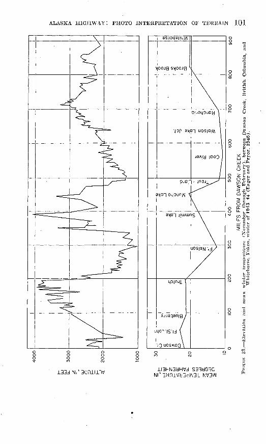
FIGURE 22. Mean monthly temperature along the Alaska Highway______ 10023. Elevation and mean winter temperature between Dawson
Creek and Whitehorse_..___J_____ _________________ _____ 10124. Sketches of leaves, flowers, and fruit of forest trees and of
dwarf birch pnd scrub-type willow._____________________ 10425. White spruce and balsam poplar on Liard River flood plain. _ J0826. Lodgepole-pine forest on terrace near eastern end of Watson
Lake _________-_____---_____---_---__-------__--_-___ 11027. Aspen forest on steep south-facing bluff on north side of
Beatton River valley..-___---.._---_-_-___-___________- Ill28. White spruce, aspen, and lodgepole pine on upland between
Liard River and Watson Lake________--_----___._______ 11229. White spruce, alpine fir, lodgepole pine, and black spruce in
foothill forest on Morley River-McNaughton River divide. . 11430. Black spruce-lodgepole pine-white spruce forest in Beatton
Valley---------------------------------.----.-------- 11531. Valley of Beatton River__--------.____-__---_.__________ 11632. Dwarf-birch and willow scrub after fire on plain along Beatton
River.__--__-__-_____-___--______-__----_-__________ 116
TABLE
TABLES
1. Climatological data for selected localities in Alaska, Yukon,and British Columbia.________________________________ 102
2. Extent of permafrost on 437-mile section of Alaska Highway. _ 1033. Identification of vegetation types on aerial photographs in
terms of various terrain characteristics..---__________ In pocket
KEYS
Key for identification, on the ground, of the common forest trees along the southern part of the Alaska Highway._____________________________ 105
Key for identification of vegetation on aerial photographs ______________ 124
By HUGH M. RAUP and CHARLES S. DENNT
ABSTRACT
This paper is an attempt to apply the combined knowledge and techniques of botany and geology to the photo interpretation of terrain in northern regions in particular, the area along the southern part of the Alaska Highway in British Columbia and southeastern lukon, where the forests are composed pri marily of only a few species of trees. The authors describe the uses and limita tions of these trees and associated shrubs as indicators of such characteristics of the ground on which they grow as soil texture, drainage, presence or absence of permafrost, stability of slopes, and trafficability. Many of the individual species or groups of species, it is pointed out, can be identified on aerial photo graphs at scales of 1: 20,000 or less if one has a general knowledge of the geog raphy of the principal vegetation types and if some account is taken of their topographic position whether, for example, they grow on terraces, on steep mountain slopes, or above the timber line.
The paper includes a brief discussion of the following topics : the local terrain ; climate and permafrost; identification of the common forest trees on the ground ; the forest types and their relation to the local terrain; the geographic extent of the forests in northern British Columbia and southeastern Yukon; and the modification of the forests after fire. A key for the identification of the vegeta tion oh aerial photographs is given. Aerial photographs arranged as stereo- triplets illustrate the methods of identifying the vegetation; they are accom panied by outline maps that delineate the vegetation types visible on each photograph; and the terrain interpretation based on the local vegetation and topography visible on each triplet is stated briefly.
INTRODUCTION
PURPOSE OF STUDY j
The present report is a part of the terrain-intelligence studies being carried on by the Military Geology Branch of the United States Geo logical Survej7 . In it the authors have attempted to apply the com bined knowledge and techniques of both botany and geology to the photo interpretation of terrain in northern regions.
The forests along the southern part of the Alaska Highway are com posed primarily of only a few species of trees. These trees and asso ciated shrubs are arranged over the landscape in groups or combina tions that appear to be closely related to the kind of ground on which they grow specifically, to such features of the terrain as soil
95

96 MINERAL RESOURCES OF ALASKA, 1945-46
texture, drainage, slope, exposure, and altitude. Many of the indi vidual species or groups of species can be identified on aerial photo graphs if the scale is sufficiently large and if some account is taken of their topographic position. One should note, for example, whether they grow on terraces, on steep mountain slopes, or above the timber line.
The purpose of the present study is to show the uses and limitations of the vegetation along the southern part of the Alaska Highway as an indicator of the kind of ground on which it grows. Such character istics of this ground as soil texture, drainage, presence or absence of permafrost, stability of slopes, and trafficability are taken into consid eration. The study is applicable to the area immediately adjacent to the highway in British Columbia and southeastern Yukon, but with minor alterations it should prove serviceable for adjacent parts of Canada, because similar forests and similar types of associated vege tation range widely over large areas on either side of the highway (pi. 9).
The interpretation of vegetation on aerial photographs depends first of all on a general knowledge of the geography of the principal vegetation types to be found in any given region. In addition, it is useful to know in advance how these vegetation types are distributed over the landscape. Such information can usually be obtained from rapid ground reconnaissance in the area or from a general knowledge of the character of the vegetation in surrounding regions. Before using the key given in this report to interpret photographs of Alaskan vegetation, for example, it would be advisable to study published reports on the vegetation of that area in order to find out whether the same or similar types of vegetation are present and where they occur. Such background study would be even more important before applying this or any ke}^ to photographs of vegetation in more remote places such as northeastern Siberia.
The success achieved by the methods outlined here is due to several factors, the most important of which are the relative immaturity of the soils, a vegetational complex also notable for its immaturity, and a climate conducive to frequent burning of the vegetation. The forest types are closely related to the kinds of ground on which they grow. For example, lodgepole pine growing in relatively open stands on rather flat terrain, such as a terrace along a stream, indicates a sandy or gravelly subsoil. The maturing of soils and vegetations in areas that have remained undisturbed by glaciation for a long period tends to obscure the relationship between forest types and kinds of ground, but in the region under consideration the disappearance of glacial con ditions has been sufficiently recent to maintain a more direct relation ship. Forest fires, because they have tended to hold back the matur-

ALASKA HIGHWAY: PHOTO INTERPRETATION OF TEKRAIN 97
ing of the vegetation, have made it possible to clarify still further the coincidence of forest types and kinds of ground.
Aerial photographs of the section from Fort Nelson to Whitehorse were studied on the ground, chiefly in the form of a traverse along the highway with several side trips into the country immediately adja cent to the road. Photographs of the section from Fort St. John to Fort Nelson were studied in the office. The six significant species of forest trees are described individually. General characteristics and means of identification on the ground are given, together with the trees' distribution along the highway, their modification after fire, and their significance, singly and in groups, with regard to the nature of the ground on which they grow. Their use as indicators is sum marized in chart form, and a key to the identification of these forest types on aerial photographs, with several examples illustrating its use, has been provided.
FIELD WORK AND ACKNOWLEDGMENTS
The results given herein were obtained by the authors on a botanical and glacial-geological reconnaissance of the southern section of the highway. Three months, June to September 1943, were spent between Dawson Creek, British Columbia, and Whitehorse, Yukon. The work was done under the combined auspices of the Arnold Arboretum of Harvard University, the Geological Society of America, and the Joint Economic Committees of Canada and the United States. Through the Joint Economic Committees transportation over the highway was procured from the United States Army. Thanks are .due these organ izations for their splendid support. Denny is most grateful to Wes- leyan University, Middletown, Conn., for granting him leave of absence to carry on the field work, and special thanks are due Wendell E. Thorne, of the Joint Economic Committees, R. E. Royall and W. T. Pry or, of the United States Public Roads Administration, and J. T. Hack and S. K. Neuschel, of the United States Geological Survey.
GEOGRAPHIC SETTING
From Dawson Creek, British Columbia, to Whitehorse, Yukon, the Alaska Highway traverses the plains of western Canada, passes through the northern end of the Rocky Mountains, and enters the southern Yukon plateau by way of the Liard, Rancheria, and Mc- Naughton River valleys (pi. 9). The entire region was covered by ice in the glacial period (Denny and Sticht, 1950). The valleys are floored with sand and silt deposited in glacial lakes or by gravel terraces along the flood plains of the principal streams. The soils are thin and variable. In general those east of the Rocky Mountains, in the foothills or on the Alberta plateau, are more likely to be high in silt and clay as compared with the sandier soils of the terraces in the

98 MINERAL RESOURCES OF ALASKA, 1945-46
Rocky Mountains, along the Liard, Rancheria, and McNaughton Rivers, and around the numerous lakes of southeastern Yukon.
From Dawsori Creek to Fort Nelson, British Columbia, the highway follows the western edge of the Alberta plateau, which is underlain by essentially flat-lying beds of sandstone, shale, and conglomerate. The plateau ranges in altitude from about 3,000 to 4,000 feet and is dissected to depths of more than 1,000 feet by eastward-flowing streams from the Rocky Mountains such as the Peace, Sikanni Chief, Prophet, and Muskwa Rivers. The foothills between the steep west-facing escarpment of the plateau and the Rocky Mountain front are broad lowlands underlain by. shale with many, more or less isolated, north- south ridges of more resistant rock. These lowlands are floored in many places with glacial sand, silt, and clay, which form broad, poorly drained plains or low plateaus. In many places the soils probably are heavy and leached only slightly (Leahey, 1943, p. 2).
West of Fort Nelson the highway passes through the northern end of the Rocky Mountains by way of Summit and Muncho Lakes. Near Summit Lake it rises to an altitude of about 4,250 feet, which is only about 600 feet below the timber line in this vicinity. The road is built along terraces on the sides of narrow valleys or follows the edges of the flood plains.
Through most of its length in the Liard plain and through the Cas- siar Mountains the highway follows terraces along the valley side. East of Coal River the valley is narrow, and the altitude of the flood plain ranges from about 1,300 to 1,500 feet. Near Watson Lake the river flows through a broad lowland characterized by great gravel plains dotted with many lakes and dissected to depths of several hun dred feet by the Liard River and its tributaries. These plains are at altitudes of 2,300 to 2,500 feet. The valleys are again more restricted in the drainage of the upper Rancheria and McNaughton Rivers, where the highway passes through the northern end of the Cassiar Mountains. The Continental Divide between MacKenzie and Yukon drainage is at an altitude of about 3,200 feet.
In the southern Yukon plateau the main drainage lines and the big lakes follow long narrow valleys that trend north or northwest. The larger lakes are at altitudes of about 2,200 feet. The surrounding peaks rise to 2,500 to 3,000 feet above the valleys, and many of them are flat-topped. The lakes and valleys of the southern Yukon plateau are bordered in many places by terraces that are underlain either by sand and gravel, or by sand, silt, and clay. Leahey (1943) notes that the soils in the region from Teslin Lake to Whitehorse are not deeply weathered and that there are few signs of the definite leached layer so characteristic of woodland soils in northern latitudes. He states:
Some incipient development of the characteristic light grey A-2 horizon of the podsolic soils was noted under spruce on light textured soils in a few local

ALASKA HIGHWAY: PHOTO INTERPRETATION OF TERRAIN 99
areas. * * * The surface soils of the Yukon have two prevailing colors depending on drainage conditions. The well-drained soils are distinctly reddish brown in colour while the poorly drained and recent soils of the floodplains are black or dark grey in colour. * * * All the mineral soils of the Yukon are comparatively low in organic matter.
CLIMATE
The climate of the region is subarctic, characterized by relatively short summers and long, cold, dry winters. Temperature and rainfall data are given in table 1. Figure 22 shows the mean monthly tempera ture for a normal year, based on records of 5 years or more, as com pared with the years 1942-43 and 1943-44. Figure 23 shows that the mean winter temperatures during 1943-44 (November through Febru ary) were lowest at low elevations that is, in valleys. For example, the mean winter temperatures at Blueberry, Trutch, Summit Lake, and Muncho Lake were higher than those at? Fort Nelson or along the Liard and Rancheria Rivers.
In midwinter, at about latitude 60° N. (Watson Lake to White- horse) , the sun is above the horizon for only 6 hours daily, whereas in midsummer the sun is visible for 19 hours. The generally low altitude of the sun throughout the year accentuates the differences in insolation between north- and south-facing slopes. The slopes that face south commonly show more evidence of mass movement of the soil; moreover, the vegetation is not the same as on north-facing slopes and generally appears to be more disturbed by present-day frost heaving.
About 60 percent of the precipitation, or 7 to 10 inches, occurs during the months from May through September. The total precipi tation ranges from about 11 to 16 inches a year.
In spring the Peace River ice usually begins to run in the latter part of April and sets again after mid-October or sometimes as late as mid- November. The Liard ice breaks up a week or 10 days later in the spring and sets a few days earlier in the autumn. The ice in the Lewes River at Whitehorse usually breaks up about May 15, and the river freezes over in October.
PERMAFROST
Permafrost, or permanently frozen ground (Muller, 1945), is wide spread in southwestern Yukon and Alaska but is apparently of much more limited occurrence in southeastern Yukon and northern British Columbia, the area considered in this report. From Whitehorse southeastward to the upper crossing of the Liard River near Watson Lake, a distance of about 275 miles, the highway was built over perma frost for only about 19 miles, or 6.5 percent of that distance; in the section south of the lower crossing of the Liard River almost no perma-

TE
MP
ER
AT
UR
E,
IN
DE
GR
EE
S
FA
HR
EN
HE
ITO
O
ALASKA HIGHWAY: PHOTO INTERPRETATION OF TERRAIN 101
t^r-t
133d Nl' 3anili"lV H3HN3bHVJ S33d93Q Nl' 3biniVH3dlAJ31 NV31AI

TA
BL
E 1
. C
lim
ato
locj
ical
da
ta f
or
sele
cted
lo
cali
ties
in A
lask
a,
Yu
ko
n,
and B
riti
sh C
olu
mb
ia
[Ada
pted
fro
m E
ager
and
Pry
or (
1945
). B
ased
on
data
fro
m C
anad
ian
Dep
artm
ent
of T
rans
port
and
U.
S. W
eath
er B
urea
u (f
or p
erio
ds o
f 5
year
s or
mor
e)]
Pla
ce
Tem
pera
ture
(°
F.)
Mea
n an
nual 20
27
31
.4
30
35
Max
imum
99
84
90
98
105
Min
imum -G
O
-69
-61
-5
4
-65
Pre
cipi
tati
on (
inch
es)
Sum
mer
ave
rage
(M
ay-S
epte
mbe
r)
Rai
n 7.09
8.
27
7.73
9.
86
Sno
w
3.5
1.6 .7
1.4
Win
ter
aver
age
(Oct
ober
-Apr
il)
Rai
n 0.50
.6
1 .8
5 .8
6
Snow
34.6
63
.3
52.6
48
.6
Tot
al
(wat
er) 3.96
6.
94
6.11
5.
72
Mea
n an
nual
(w
ater
) 11.8
11
.4
15.3
7 13
.9
15.7
o bO ft)

ALASKA HIGHWAY: PHOTO INTERPRETATION OF TERRAIN 103
frost was encountered. (See table 2.) Table 1 shows that the mean annual temperature is above 30° for most of the area from Whitehorse southeastward, indicating in general an average temperature above freezing, too high for the formation of large areas of permafrost.
TABLE 2. Extent of permafrost on 437-mile section of Alaska Highway from Prochniak Creek to Whitehorse
[Adapted from Eager and Pryor (1945)1
Highway section
Upper crossins; of Liard River to Nisutlin River... ........... __ ..
TotaL.... . ...... ..-.--.... ..--... .......................
Section length (miles)
16.4 14C.2 160.9 33.1 80.3
436.9
Highway over permafrost
Miles
0 .5
7.0 9.0 2.0
18.5
Percent
0 .3
4.4 27.2 2.5
4.2
Not only is permafrost more widespread, but its effect on vegeta tion is more pronounced in southwestern Yukon and Alaska than in the region traversed by the southern section of the highway. In gen eral it appears that forests retard the development of permafrost and its resultant effects and that the areas of permafrost along the southern section of the highway may be relics of much more extensive areas of ground ice formed in the distant past (the glacial or Pleistocene epoch of geologic time). The results given in this paper are therefore di rectly applicable only to areas where permafrost is not widespread or is at a considerable depth below the surface of the ground. Some what different relationships may be present in Alaska, as is shown by recent work in that area (Belcher, 1945; Elias and Vosburgh, 1946).
IDENTIFICATION, ON THE GROUND, OF THE COMMONFOREST TREES
Although the primary problems involved in this paper are concerned with the identification of forest types as seen from the air, it is thought that some information regarding the ground determination of the trees will be useful. The application of ground controls to the inter pretation of vegetation from aerial photographs is desirable whenever it is possible, and ,a knowledge of the common species of trees is essen tial for such controls.
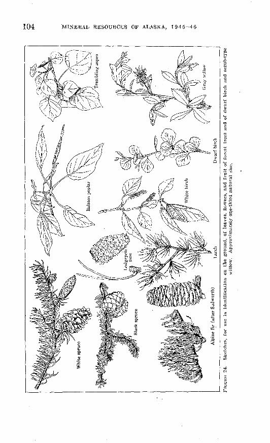
On page 105 is a simple key for the identification of the trees that grow along the southern part of the Alaska Highway. They are as follows: alpine fir, white spruce, black spruce, Engelmann spruce, lodgepole pine, larch, trembling aspen, balsam poplar, and white birch. Sketches of the leaves, flowers, and fruit of the forest trees are given
104 MINERAL RESOURCES OF ALASKA, 1945-46
a S

ALASKA HIGHWAY: PHOTO INTERPRETATION OF TERRAIN 105
Key for identification, on the ground, of the common forest trees along the southern part of the Alaska Highway
1. Leaves needlelike; flowers and fruit in cones.2. Leaves numerous on twigs but borne singly (not in groups or
fascicles), usually short (1 inch or less). 3. Young twigs smooth (with no fine hairs).
4. Cones upright on twigs; bark light gray, smooth, with resin blisters; leaves short, borne directly on twigs, with no short, persistent stalks.___________ Alpine fir
4. Cones pendent from twigs, longer than broad, with thin scales; bark dark gray, smooth or deeply fissured; leaves short, borne on short stalks that persist when leaves are pulled off _____________ White spruce
3. Young twigs covered with short, fine hairs.5. Cones pendent on twigs, rounded, usually borne in
pairs, purplish when young, usually bunched in top of tree; commonest in muskegs and on uplands with clayey soils,___________________________ Black spruce
5. Cones pendent on twigs and scattered on tree, much longer than broad; tree of upland forests, ap parently rare___.______________________ Engelmann spruce
2. Leaves borne in fascicles or groups, on short lateral projections from twigs.
6. Leaves in fascicles of two, needlelike, often 2 inches or more long; cones conical, of hard scales each of which has a thornlike prickle at the end; bark dark gray, rough, and scaly_--------__-_--____-___-__--________ Lodgepole pine
6. Leaves many in each fascicle, short (usually 1 inch long or less), deciduous; cones small (less than 1 inch long), ovoid, of a few thin scales that are greenish when young but turn brown at maturity._____-___-_--__-_-_-___ Larch
1. Leaves broad, not needlelike, deciduous; flowers and fruit in catkins.
7. Bark greenish or yellowish green to white on branches andyoung trees, corky, fissured, and gray on old trunks, notpeeling in thin papery sheets around tree; twigs smooth.
8. Leaves small, bluish green, broadly oval to rounded orheart-shaped, toothed, borne on thin petioles that areflattened vertically; buds without a noticeable stickygum or resin________________________________ Trembling aspen
8. Leaves larger than in aspen, bright green above and paler green beneath, ovate-lanceolate in outline, crenate on margin; buds covered with a sticky aromatic resin; terminal buds large.___________________________ Balsam poplar
7. Bark reddish brown or white on young trees, usually white on old trees, peeling in thin sheets around tree that is, trans verse to main axes of trunk and branches; twigs commonly beset with globules of resin; leaves ovate, toothed, rounded to wedge-shaped at base_----_-__--_--_----_---------- White birch
106 MINERAL RESOURCES OF ALASKA, 1945-46
in figure.24. All the trees are common except one, the Engelmann spruce, of which there is only a single record (between the Beatton and Sikanni Rivers). A key to shrubby species would be too long and involved for the present paper, for there are upwards of 50 common ones. As far as their effect upon the appearance of the photographs is concerned, the dwarf birch (Betula glandulosa) and certain of the willows (Salix spp.) are by far the most important.
Figure 24 contains a sketch of the dwarf birch and one of a common upland willow. The dwarf birch is a rather densely formed shrub that ranges in size from a low mat on the ground to a height of 4 feet or more. Its leaves are small (y2 to 1*4 inches long), rounded at the apex, and margined with a few rounded teeth. The twigs are warty, with globules of a resinous substance.
There are many species of willow along the Alaska Highway. They range in size from the tiny mat plants of the alpine tundra to large shrubs in woods and thickets at lower altitudes. A few attain the proportions of trees, with single trunks that are small in diameter (2 to 6 inches) but tall enough to reach the tops of the smaller forests (40 to 50 feet). Most willows grow along watercourses or in muskegs, though a few prefer upland woods. Among those most characteristic of the uplands is the gray willow (Salix Bebbiana] , which is common in aspen-spruce woods and grows up in dense thickets with aspen after fires. One of the willows most frequently seen in muskegs and dwarf- birch scrub is Salix glauca; around grass and sedge marshes Salix planifolia is common. The sand-bar willow (Salix interior var. pedi- cellata] is the commonest form on river flood-plain bars.
FOREST TYPES AND THEIR RELATION TO THE LOCALTERRAIN
The more significant types of vegetation along the Alaska Highway are forests, dwarf-birch and willow scrub, and alpine tundra. By far the most important are the forests, which cover nearly all the coun try through which the road passes. These forests are composed prin cipally of white spruce, black spruce, alpine fir, lodgepole pine, aspen, and balsam poplar. White birch and larch are common trees in some regions, but nowhere do they dominate the vegetation. The trees sometimes occur in pure stands, but more commonly they are in mix tures of various kinds. Many of these mixtures are due to fire. Alpine tundra, together with scrub composed of dwarf birch and willow, is characteristic of areas above the timber line. (The upper limit of timber is at altitudes between 4,500 and 5,000 feet.) Dwarf-birch and willow scrub is common, also, in some parts of the foothills east of the Rocky Mountains.
In the following discussion the distribution and significance of the

ALASKA HIGHWAY: PHOTO INTERPRETATION OF TERRAIN 107
trees will be treated, first as they occur in nearly pure stands, and second as they occur in the common types of mixtures to be seen in the region.
WHITE SPRUCE
[Picea glauca vars.]
Flood-plain forests. L&Tge, trees, more than 100 feet high and with breast-height diameters of 18 to 24 inches, commonly occur on banks of streams and near old sloughs on flood plains of the larger rivers (fig. 25). They grow in silt-loam to gravelly soils over silt, sand, and gravelly substrata. These trees represent a great deal of the usable timber available along the highway. The ground is fairly easy to excavate. Wet sloughs, low ridges, and dense woods restrict or stop the movement of vehicles, but in winter the frozen rivers are generally trafficable b}^ wheeled vehicles. The soils are well drained, but the water table may be high. There is danger of flooding.
Upland forests. In pure stands on uplands white spruce is not clearly indicative of any particular ground conditions, though it usually occurs on the better-drained soils. A pure stand of white spruce is an old forest, not burned for many years. It has not been possible to distinguish white from black spruce on the photographs by direct examination, but usually the two can be separated by a con sideration of the local topography. (For a discussion of methods see pp. 122-123.) Owing to the frequency of fires pure stands of white spruce on the uplands are uncommon. However, north-facing moun tain slopes above an altitude of about 3,500 feet are usually covered with white spruce (pi. 12).
' $ »: BLACK SPRUCE
[Picea mariana]
Muskeg forests. The muskeg forests occur at all altitudes in areas of moderate to low relief with poor drainage; they generally surround ponds or wholly or partly cover more or less level depressions. The soil is variable but generally heavy, and in many places it is overlain by a few feet of peat and muck. The water table is near the surface in many localities. Commonly the muskeg forests are associated with dwarf birch, willows, and deep moss. Except in winter large areas of muskeg are difficult to traverse on foot, on horseback, or with mecha nized equipment. The muskegs in the section from Dawson Creek to Whitehorse commonly are not frozen in late summer, at least within several feet of the surface.
Upland forests. Black spruce rarely occurs in pure stands except in muskegs or on rocky north-facing mountain slopes below altitudes
889407 50 2

108 MINERAL RESOURCES OF ALASKA, 1945-46
FIGURE 25. White spruce and balsam poplar on Liard River flood plain near Lower Post,British Columbia.
of about 3,500 feet. On certain types of terrain described under "Mixed forests" (p. 113) it occasionally approaches a pure stand.
LODGBPOIjE PINE
,':/.:: : : [Pinus contorta var. latifolia] -._- :
Lodgepole pine commonly occurs in nearly pure stands or associated with white spruce on stream terraces with sandy and gravelly subsoils.

ALASKA HIGHWAY: PHOTO INTERPRETATION OF TERRAIN 109
The soil is easy to excavate, and the water table is low; the ground is not likely to be frozen. Terraces may or may not show small im- drained depressions or ponds (kettle holes). Pure stands of lodge- pole pine are generally good sites for highway construction or for airports if sufficiently large, as at Watson Lake (fig. 26). Commonly lodgepole pine is a good indicator of sandy ground. Exceptions are in recent burns on heavier soils where nearly pure stands of lodgepole pine may form initial stages in the rehabilitation of white-spruce forests.
ASPEN
[Populus tremuloides]
Aspen commonly occurs in nearly pure stands at the edges of ter races where the water table and any permafrost that may be present are at a considerable depth. It also is found on dry soil in burned areas (fig. 27). The soil is commonly a fairly heavy clay derived from a stony cl&y or clay substratum; it is difficult to excavate and likely to be muddy when wet. The occurrence of aspen on the edges of terraces for example, along the Beatton River (fig. 31, pis. 15, 16) commonly indicates better drainage near the terrace edges than farther back. Aspen in nearly pure stands is more common on the relatively heavy soils east of the Rocky Mountains than elsewhere along the highway. Here it appears to be most highly developed on steep south-facing' slopes (fig. 27), except in the semiopen prairie country of the Peace River agricultural district where it margins the grassland.
BALSAM POPLAR
[Populus tacamahacca]
Balsam poplar occurs in pure stands 011 .only two types of site. On lowland river flood plains it is the first forest that develops on new deposits (fig. 25), and it is soon replaced by flood-plain white spruce (see p. 107) ; thus it usually appears in narrow bands on the higher sand bars. The same kind of ground indicated by flood-plain spruce is indicated by balsam poplar. The poplar also occurs, often in scrubby form, on sand and gravel fans in the mountains.
MIXED FOBESTS
WHITE SPRUCE, ASPEN, AND LODGEPOLE PINE
This type of forest is widespread on rolling uplands and terraces that have been burned (fig. 28). It is probably the commonest forest type to be seen between Dawson Creek and Whitehorse, growing on soils varying from silty clay loam to gravel. On dry sandy or gravelly phases of the loams the pine is predominant in the mixture (fig. 26). On steep south-facing slopes aspen is most abundant. The mixture

110 MINERAL RESOURCES OF ALASKA, 1945-46
FIGURE 2)6.- Lodgepole-plne forest on irrnir,' nr.-n- i. : i>n.|-n fml <>[' Watson I,: Loamy and sandy soils over sand ami snivel .subMlratum.

ALASKA HIGHWAY: PHOTO INTERPRETATION OF TEBRAIN 111
FIGURE 27. Aspen forest on steep south-facing bluff on north side of Beatton River valley just east of Army pioneer road (along transect A~A', pi. 14).
as a whole is a stage in reforestation after burning (see pp. 118-119); when the mixture ages the spruce becomes predominant.
WHITE SPRUCE, ASPEN, AND BALSAM POPLAR \ V '
Forests of these trees occur on uplands in the Peace River agricul tural district but disappear a short distance north of Fort St. John.

112 MINERAL RESOURCES OF ALASKA, 1945-46
FIGURE 28. White spruce, aspen, and lodgepole pine on upland between Liard Riverand Watson Lake.
A suggestion of this type of mixed forest is seen north of the Muskwa River near Fort Nelson. :
WHITE SPRUCE, ALPINE FIR, LODGEPOLE PINE, AND BLACK SPRUCE
These trees are common as a tall forest on steep mountain slopes in the foothills (fig. 29). It is an old forest that has not been burned

ALASKA HIGHWAY: PHOTO INTERPRETATION OF TERRAIN 113
for a long time. Alpine fir (Abies lasiocarpa) cannot be distinguished from spruce on the photographs. Both spruce and fir are suitable for construction purposes.
BLACK SPRUCE, LODGEPOLE PINE, AND WHITE SPRUCE, WITH ORWITHOUT ASPEN
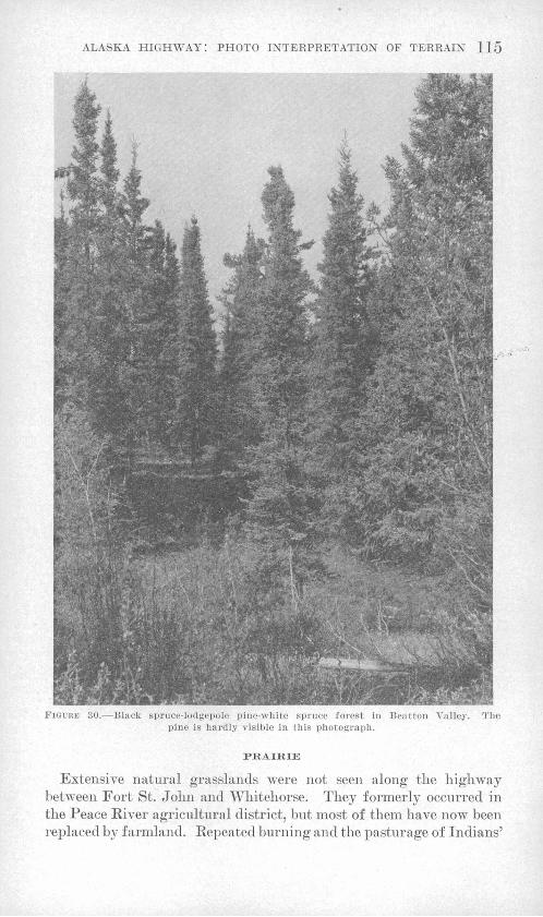
This type of forest occurs on long gentle slopes showing faint, shal low, subparallel drainage channels underlain by heavy clay soils derived from stony clay or clay substrata (fig. 30). On such sites it has the appearance of muskeg, with wet moss on the ground. It is common, also, on the Alberta plateau east of the Rocky Mountains, where it occurs on heavy clay soils over stony clay substrata 011 un dulating and gently rolling land (fig. 31). It is very subject to burn ing, which produces wide expanses of willow and dwarf birch among which young spruces and pines grow up. The surface soil is sticky when wet, and the water table is always near the surface. The ground is difficult to excavate with hand tools. Permafrost is generally absent in areas east of the Rocky Mountains; elsewhere it is present only in a few scattered localities.
FLOOD-PLAIN WILLOWS
These are willows growing at the edges of sloughs on flood plains, where they margin the white spruce and balsam poplar in sandy and silty clay soils with the water table at or near the surface. The ground is miry in wet weather, and there is danger of flooding. The thick undergrowth is difficult to traverse on foot.
UPLAND WILLOWS
These willows are common after recent burns over various soils, slopes, and drainage conditions, but they are most abundant over loamy soils that are fairly well drained.
DWARF BIRCH AND WILLOW
The dwarf birch and willow occur (1) as a zone just above the timber line on mountain slopes; (2) associated with black spruce and heath shrubs in muskegs; and (3), after fire, in the black spruce- lodgepole pine-white spruce-aspen forest (fig. 32) on heavy clay soils. (See the descriptions of these two forest types for the kind of ground indicated.)
ALPINE TUNDRA AND DWARF-BIRCH SCRUB
These are found above the timber line. In the Summit Lake area (northern end of the Rocky Mountains) they occur above an altitude of about 4,500 feet on north-facing slopes and nearly 5,000 feet on south-facing slopes (pi. 12). Near the Continental Divide, along the upper Rancheria and McNaughton Rivers, the timber line is at about

114 MINERAL RESOURCES OF ALASKA, 1945-46
FIGURE 29. White spruce, alpine fir, lodgepole pine, and black spruce in foothill forest on Morley River-McNaughton River divide.
4,500 feet. The soil and subsoil are highly variable but generally stony in many places. The ground is often wet, especially early in the sum mer, and it may be frozen. The slopes are unstable and likely to slump. A thick growth of dwarf birch is difficult to traverse on foot, and alpine tundra on steep slopes is slippery even in dry weather. Visibility both from the ground and from the air is unobstructed.
ALASKA HIGHWAY: PHOTO INTERPRETATION OF TERRAIN 115
FIGURK 30. Black spruce-lodgepole pine-white spruce forest in Beatton Valley. The pine is hardly visible in this photograph.
PRAIRIE
Extensive natural grasslands were not seen along the highway between Fort St. John and Whitehorse. They formerly occurred in the Peace River agricultural district, but most of them have now been replaced by farmland. Repeated burning and the pasturage of Indians'

116 MINERAL RESOURCES OF ALASKA, 1945-46
FIGURE 31. Valley of Beatton Itiver. View northwest from top of plateau east of Alaska Highway and south of river (for location see pi. 14). Flood plain with scrub growth of willows and numerous abandoned sloughs surrounded by marsh. Conspicuous small stands of white spruce and a few scattered aspens on natural levees. Abundant aspen, not yet in leaf (very light gray), on slope on north (right-hand) side of flood plain leading up to plain between river and bordering uplands in right background. Pine more abundant than aspen on slope to south of river (at left). Army pioneer road ascends to top of plateau in right background. Pine, aspen, and spruce on slope in foreground. Compare with plate 16.
I<'IGUI:B ;;2.- l>\varl-hircii and willow scrub after fire on plain along Beatton River, clay soils over clay and silt or stony clay substrata.
Heavy

ALASKA HIGHWAY: PHOTO INTERPRETATION OF TERRAIN 117
horses have produced a few small openings at the Beatton and Buck- inghorse Rivers on heavy clay soils formerly occupied by the black spruce-white spruce-lodgepole pine type of forest, and a small area east of the road in the valley of the Beatton River is covered by what appear to be natural semiopen prairies margined by willows and~aspens (fig. 32, pi. 16). Prairies are indicators of heavy clay soils.
GEOGRAPHIC EXTENT OF THE FOREST TYPES
Two maps of forest types in the region under discussion have been published in recent years. They indicate the areal configuration of the types that are seen in section along the highway and should be consulted in the interpretation of photographs of this region. The first was published by Halliclay (1937) and is part of a map of forest sections in all Canada. Halliday's map has been modified and cor rected by Raup (1945) for the region of the Alaska Highway between Dawson Creek and Whitehorse. The forest sections of this second, modified map are shown here on plate 9.
It will be noted that the forests of the region are classified and mapped by Halliday and Raup in "sections," seven of which appear along the highway: Aspen Grove, Mixedwood, Foothills, Upper Liard, Mackenzie Lowlands, Teslin, and Kluane Lake. Only four of these sections Foothills, Upper Liard, Mackenzie Lowlands, and Teslin are of primary importance in the area covered in this paper. The Mackenzie Lowlands section is equivalent to the flood plain spruce- balsam poplar type described in this paper. The Upper Liard and Teslin sections are both dominated by white spruce, with a great variety of modifications due to fire and local soil peculiarities, chiefly involving lodgepole pine and aspen either in pure stands or in mixtures with the spruce. These two sections are not readily separable on the photographs, but for purposes of ground analysis they are essentially similar, so that their separation is not necessary. The Foothills sec tion of the maps consists of two types of forests, one of which occurs on steep mountain slopes and is covered by the white spruce-alpine fir-lodgepole pine-black spruce type of the present paper. The other is on the plains and high plateaus east of the Rocky Mountains and on the Liard Plain; it is the black spruce-lodgepole pine-white spruce type (with or without aspen).
The Aspen Grove section of the maps is limited to the Peace River district, where it is essentially coincident with the agricultural area. A small occurrence of this section was noted at the Beatton River, and a suggestion of it along the Muskwa River near Fort Nelson. The Mixedwood section is similar, for the purposes of this report, to the Upper Liard and Teslin sections, involving white spruce, jack pine, and aspen with the addition of balsam poplar. In the Kluane Lake

118 MINERAL RESOURCES OF ALASKA, 1945-46
section, which appears in the neighborhood of Whitehorse, the lodge- pole pine becomes somewhat less abundant, particularly in spruce for ests altered by fire.
MODIFICATION OF THE FORESTS AFTER FIRE
Fire has had a profound influence in the determination of forest composition throughout most of the country traversed by the highway. Stands of timber that do not show some effects of fire are rare. Many photographs show irregularly shaped areas of different forest types that appear at first glance to be due to variations in terrain but are actually due to the irregular outlines of old burns. Some fires have occurred quite recently, whereas others took place so long ago that they can be detected only by the presence of bits of charcoal in the soil. The spruces and pine of which most of the forests are composed do not sprout from the roots when their trunks are burned, but depend upon reseeding for the replacement of the stand. Very commonly the reseeding is delayed for various reasons, often for a period of many years; thus fires, occurring at various times, have brought about an extremely complex pattern of types in the existing timber. Some un derstanding of the effects of fire is therefore essential to the interpre tation of aerial photographs in terms of actual conditions on the ground.
Much of the country discussed here would probably have a forest of white spruce if it had never been burned. In the muskegs, how ever, black spruce might predominate; uplands with heavy clay soils would probably carry a forest of black spruce variously mixed with white spruce; and extremely dry, sandy areas might maintain an open forest of lodgepole pine. The interpretation of ground conditions from the forests would then be very difficult, for the white spruce would cover nearly every type of terrain except the very wet and the very dry. In effect, therefore, one result of repeated burning has been to unmask some of the relationships between forests and terrain. The developmental stages that follow fire differ with the kinds of soil, whereas the mature or unburned forest does not.
The burning of forests on the uplands along the Liard River, where there are silt-loam to gravelly soils derived from sand, gravel, or stony &ilt substrata, introduces various mixtures of pine, aspen, and spruce. The composition of any given stand depends upon the intensity of the fire, its timing with relation to seed years, and the local conditions of soil, slope, and exposure. On south-facing bluffs and slopes, where drainage is good and the ground thaws early in the season, there is likely to be more aspen in the resulting mixture, as illustrated on the right-hand side of plate 11 and near the upper left-hand corner of plate 10. North-facing slopes, where the ground remains frozen

ALASKA HIGHWAY: PHOTO INTERPRETATION OF TE;RRAIN 119
longer, are likely to have purer mixtures of spruce. Intense fires ap pear to bring about nearly pure stands of pine or forests of pine mixed with spruce, whereas crown fires that do not destroy all the ground cover result in mixtures of spruce, aspen, and pine. The white spruce is likely to appear in burn communities later than the aspen and pine, so that a common association is one of aspens and pines 40 or 50 feet tall, with scarcely any reproduction of these species, but with many young white spruces coming up. On the photographs, therefore, some areas mapped as aspen, pine, and spruce do not show much evidence of the spruce, but if the new forest is well grown, the spruce is almost inevitably present in the understory. On other sites, such as north- facing slopes that have been burned off, young spruce may seed in at the same time as the pine if the fire has not been too destructive.
The aspen-pine-spruce mixtures frequently are reburned. When this happens, a few scattered aspens commonly are left, because the aspen is not quite so susceptible to fire damage as the conifers. The result is a sort of park land or savanna in which large aspens stand above a community of upland willows and young conifers. Such a fire is not so intense as one that destroys all the aspens; therefore the willow and small-tree cover that grows up is usually rather dense, containing both young spruces and young pines. The abundance of upland willows in such a community appears to be due to their having, like the aspens, survived the fire. This type of park land is quite common in the region as a whole, though it is best developed on areas of heavy soils that have a high water-holding capacity and are not so completely sterilized by burning (pis. 15, 16).
In the interpretation of ground conditions from vegetation along the upper Liard River, the outstanding factors are the abundance of lodgepole pine in all the upland burns and the relatively small develop ment of aspen (pis. 10, 11), which is notable chiefly on south-facing bluffs. This combination of conditions is a strong indication of dry sandy and gravelly soils.
Burns on rolling uplands with heavy clay soils, such as those along the Muskwa River west of Fort Nelson and between Nelson and Fort St. John, give rise to temporary forests in which lodgepole pine is not nearly so important as aspen. Low hills and bluffs in the vicinity of Raspberry Creek, 35 miles west of Fort Nelson, have rather dense stands of aspen and spruce, with not enough pine to show conspicuously in the photographs (pi. 13). In some places there are nearly pure stands of aspen. In areas of moderate relief heavy groAvths of aspen not confined to south-facing bluffs strongly suggest relatively heavy "clay soils derived from stony clay or clay substrata. This is particu larly true if pines are not prominent in the mixtures.
The heaviest upland soils are those that support muskeglike forests of black spruce, lodgepole pine, and white spruce such as are found on

120 MINERAL RESOURCES OF ALASKA, 1945-46
the Alberta plateau and in the lowlands of the foothills east of the Rocky Mountains (pis. 14, 15, 16). The burning of the black spruce commonly gives rise to rather open areas in which the principal cover is of dwarf birch. The black spruce seems to return directly, without an intermediate forest stage, except 011 low bluffs above streams where aspen is dominant or in localized areas of sandy or gravelly soils where pine is dominant.
IDENTIFICATION OF VEGETATION ON AERIAL PHOTOGRAPHS
GENERAL DISCUSSION
It should again be emphasized that, in order to identify and interpret vegetation on aerial photographs, it is first of all necessary to have a general knowledge of the geography of the principal vegetation types and of their distribution over the landscape. In many cases, further more, it is essential to know the principal effects of fire and the activi ties of man. These effects differ greatly from place to place and must be worked out for each region to be studied.
The difficulty of distinguishing white from black spruce in photo graphs illustrates the value of ground reconnaissance or a preliminary study of published reports. On aerial photographs the two spruces can be distinguished only by their topographic position, not on the basis of form. Black spruce commonly occurs in muskegs throughout much of Canada, yet on long, gentle slopes showing faint, shallow drainage channels and on the high plateaus east of the Rocky Moun tains black spruce grows on heavy clay soils. Therefore, judging by the widespread occurrence of black spruce only in muskegs, the spruce on the plateaus would have been called white spruce if field study had not demonstrated that it is in fact black spruce, identifiable in photo graphs on the basis not of form but of local topography.
To be useful in interpreting vegetation, photographs must be rela tively sharp, on a scale of 1: 20,000 or less, and not noticeably tilted. The key given in this paper is applicable to photographs used with a stereoscope. Some of the criteria are of necessity variable from one photograph to another and even within the same photograph. The least satisfactory criterion is that based on shades of gray in the photo graphs. Shades differ greatly from one photograph to another owing to differences in original exposures and in printing; nevertheless, they are fairly constant for any one print. Differences in texture likewise involve a great deal of personal judgment but do not differ greatly from one photograph to the next or from one shade of gray to an other. Both these criteria can be used effectively with a certain amount of practice.
ALASKA HIGHWAY: PHOTO INTERPRETATION OF TEIRRAIN 121
The key here provided might have been arranged in various ways, depending upon the use of the different sets of criteria; however, the arrangement chosen seems most suitable for the particular set of photo graphs and vegetation types involved. For other complexes of vege tation some other combination quite probably would be more effective.
The primary subdivision is that between forested and nonforested surfaces, a tree height of about 30 feet being arbitrarily chosen as the dividing line. Even without the stereoscope, the difference in relative heights of different types of vegetation can be seen.
A second subdivision is based on the relation between vegetation boundaries and topography; those types whose boundaries are coinci dent with contour lines are separated from those whose borders usually cross the contour lines that is, extend up and down slope. This is a fundamental criterion, for it separates types of vegetation that are closely related to a ground-water level at or very near the surface from those that are not dependent upon a high water table. Among the types that depend upon a surface expression of the water table it is easy to separate those that are related to the standing water of rela tively undrained depressions (muskegs) from those dependent upon the running water of streams (flood plains). However, this signifi cant criterion becomes ineffective if there is much noticeable tilt in the photograph, for it depends upon the reliability of the contour lines.
A third criterion is texture. In the area covered it is significant chiefly in defining forest types, because types of nonforest vegetation usually show a rather uniform fine-grained surface. Differences in texture shown by the forest canopy depend upon the way in which light is reflected from the tops of the trees and are useful chiefly in dis tinguishing forests primarily of spruce or fir from those of pine, aspen, or balsam poplar. The tops of spruce trees are more or less pointed, showing relatively small dots of lighter gray against the dark background formed by the shadows farther down among the branches. This type of texture is here called "stippled." By contrast, the tops of pines, aspens, and poplars are rounded and show an abundance of leaf surfaces, brought to the top of the canopy by longer lateral branches. This texture will be called "fluffy" for want of a better word. It shows a certain amount of surface form and sometimes has a sort of "nubbly" appearance; also, in contrast to the rather sharply defined stippled type, it may appear somewhat "blurry." With practice these two types of texture are quite easily distinguished pro vided the photographs -are not on too small a scale. As a corollary, the shapes of shadows thrown by the two classes of trees form a good criterion and can easily be seen along stream banks or on the borders of openings in the forest. Spruces and firs throw pointed shadows,

122 MINERAL RESOURCES OF ALASKA, 1945-46
whereas aspens, pines, and poplars throw rounded ones. The shape of the shadows tends to be lost when the photographs are on too small a scale.
The outlines of different vegetation types as seen from the air also are useful. Generally they can be correlated directly with topo graphic patterns such as stream channels or abandoned sloughs. Rounded or irregular patterns in upland depressions, provided they follow contour lines, usually indicate some kind of bog forest or other bog type. Highly irregular patterns, generally bounding nonforested areas that appear to cross lines of texture, color, and topography and have more or less rounded or scalloped outlines, commonly indicate the boundaries of burned areas.
Three shades of gray can generally be distinguished on the photo graphs : light gray to almost white, dark gray, and very dark gray to black. As noted previously, these tones differ greatly from one photo graph to another but are fairly consistent, within any single one. Among the forests the two fluffy-textured upland types, aspen and pine, can usually be separated rather easily by color. The aspens are light gray and the pines dark. A general survey of a photograph on which both appear soon brings out the quality of the difference, which may then be applied to other photographs. Among lower-growth Among the forests the two fluffy-textured upland types, aspen and marshes, with their light-green grasses and sedges, usually appear as light gray to almost white in contrast to the darker shades of various shrubby types such as willows and dwarf birches. Nearly black areas usually represent burns that have occurred Avithin the last year or two. They are usually highly irregular in outline and are commonly streaked with lighter areas that escaped the fire by chance or because of the presence of surface water. Such lighter areas commonly follow drainage lines or the margins of muskegs or ponds.
Continuous masses of dwarf birch and willow, below the timber line, commonly are difficult to distinguish from dry grassland or grass and sedge marshes. If they occur in contact with one another they can sometimes be distinguished by their differing heights and colors, the dwarf birch and willow being taller and darker-colored. The diffi culty is not serious along the highway because dry grassland is quite rare and marsh can usually be distinguished by its areal configuration. Where dry grasslands occur they are usually on nearly level plains with heavy clay soils and subsoils; interspersed with them are willowsand dwarf birch. 3
MAPPING OF WHITE AND BLACK SPRUCE
One of the most difficult problems encountered in the mapping of forest types along the highway is the differentiation, already men tioned, of black from white spruce. These two trees have an almost
ALASKA HIGHWAY: PHOTO INTERPRETATION OF TERRAIN 123
identical appearance on the photographs. There are, however, slight differences between the tops of the two species, for the black spruce has a common habit of "bunching out" at the very top, so that the point of light reflected is likely to be a little larger than with white spruce. Under ideal photographic conditions and with pictures on a very large scale this may prove helpful, but with the great majority of photographs it is not sufficient means for distinguishing between the two species.
Throughout large parts of the country the black spruce is a charac teristic species of muskegs or bog forests. Therefore it can usually be distinguished from white spruce by the fact that its areal borders follow contour lines rather closely, whereas those types of vegetation involving white spruce are likely to cross contour lines freely unless they are on new river flood plains where black spruce is not abundant. Furthermore, areas of bog forest usually show no marked relief within themselves except as the plane of the treetops may slope evenly inward toward the centers of the depressions in* which the muskegs are located.
If this were the only habitat of the black spruce, the problem would be relatively simple, but, as noted elsewhere, there is a large devel opment of black spruce in the foothills and on the high plateaus east of the Rocky Mountains. The best criterion for the differentiation of this type on the photographs is its relation to a certain type of terrain that is characteristic of, and widespread around, the upper valleys of the Muskwa, Prophet, Minaker, Buckinghorse, and Beatton Rivers. This terrain is marked by long, relatively even, gentle slopes extending from the bases of the foothills and plateaus to the incised present-day river valleys. In general, there are few lakes and ponds, although surface drainage is only slightly developed. The stream beds, gener ally dry, are not deeply incised but are shallow yet well-defined chan nels; in many places they follow more or less parallel courses down long, even slopes and gradually converge (pi. 13). So far as is known at present, these areas have heavy clay soils with stony clay or clay substrata. For some reason that is not yet clear, the muskeglike forests that cover the surfaces of these heavy soils show the effects of fire more clearly than do those on many other upland areas.
889407 5(

124 MINERAL RESOURCES OF ALASKA, 1945-46
Key 'for identification of vegetation on aerial photographs I. Forests, trees 30 feet or more in height.
A. Fluffy texture due to predominance of trees with rounded tops against a dark background; shadows, if present, rounded.
1. Color, light gray.2. On uplands with moderate relief, usually more prom
inent on south-facing than on north-facing slopes. On river terraces, locally showing abandoned stream channels and sloughs, above flood level; generally in mixtures with a stippled type (white spruce) or a dark-gray fluffy type (lodgepole pine) _ _ Aspen (A)
2. Along stream channels or among sloughs on flood plains at or below flood level; commonly mixed with a stippled type (white spruce) ______ Balsam poplar .(T)
1. Color, dark gray. Generally on uplands of moderate relief or on high terraces with sandy and gravelly soils and in some places with small undrained depressions and ponds; commonly mixed with a light-gray fluffy type (aspen) or stippled type (white or black spruce)
Lodgepole pine (P)A. Stippled texture formed by light-gray dots against a dark-gray
background, due to reflection of light from more or less pointed tops of spruces or firs; shadows, if present, pointed; general tone dark by contrast with aspens and poplars but about the same as that of pine.
3. Areal configuration correlated with local topography; vegetation boundaries more or less parallel to contour lines or drainage patterns.
4. Vegetation types in more or less rounded or irreg ular outlines, without close relation to drain age patterns, occurring at all altitudes but com monest in areas of moderate relief and immature drainage; commonly surrounding lakes or wholly or partly covering shallow, more or less level floored depressions_-_-_-__Bog or muskeg forest of black spruce (Sb)
4. Vegetation types closely following a drainage pattern on banks of upland streams, along larger rivers covering the flood plain, or on low ridges between sloughs; commonly in mixtures with a light-gray fluffy type (balsam poplar) ___ __________ White spruce (Sw)
3. Areal configuration not obviously correlated with local topography; vegetation boundaries freely crossing con tour lines..
5. Forests of rugged mountainous districts.6. On steep, rocky north-facing slopes below alti
tudes of about 3,500 feet; usually in open stand?, commonly in mixtures with a dark-gray fluffy type (lodgepole pine) ___________ Black spruce (Sb)

ALASKA HIGHWAY: PHOTO INTERPRETATION OF TEIRRAIN 125
6. On rocky south-facing slopes at all altitudes and on both north- and south-facing slopes be tween 3,500 feet and timber line; commonly in rather dense stands at lower altitudes, generally mixed with fluffy types on south- facing slopes (lodgepole pine and aspen) _ White spruce (Sw)
5. Forests of foothills, high plateaus east of Rocky Mountains, and areas with heavy clay soils.
7. On steep south-, east-, and west-facing slopes in the foothills, usually below 3,000 feet; dense tall mixed trees, commonly with lodgepole pine and black spruce_-___-_-____-White spruce-alpine fir (Sw-F)
7. On steep north-facing slopes in foothills; com monly mixed with fluffy dark-gray type (lodge- pole pine) and white spruce___________Black spruce (Sb)
7. On high plateaus and areas of heavy soils east of Rocky Mountains; usually mixed with lodge- pole pine or white spruce or both; areas of heavy clay soils commonly characterized by long, relatively even, gentle slopes with well- defined, shallow, subparallel drainage chan nels__________________________-___Black spruce CSb)
I. No forests; vegetation of low stature, generally much less than 30 feet in height.B. Areal configuration correlated with local topography; vege
tation boundaries more or less parallel to contour lines or drainage patterns; broader areas showing little or no relief within themselves.
8. Vegetation types in more or less rounded or irregular out lines, without close relation to drainage patterns.
9. More or less continuous masses of bush growth on level to very gently sloping land that shows few or no incipient drainage patterns; commonly on broad terraces. _- _ ________________ Dwarf birch and willow (B-W)
9. Light-gray areas in this type usually dry grass land_____________________________________Grassland (G)
9. Vegetation types present at all altitudes, but com monest in areas of moderate relief and immature drainage; often with concentric arrangement of color and texture outlines; usually in shallow, level-floored depressions and commonly with patches or individual trees that throw pointed shadows (black spruce). 10. Color, light gray______________Dwarf birch and willow in
muskegs (B-W) 10. Color, light gray to almost white_______Grass and sedge
marshes (M)8. Vegetation types in narrow, shallow and elongated de
pressions that have concentric arrangement within and among themselves; commonly in flood-plain sloughs along large streams. ___._ Flood-plain willow sloughs (W)
8. Vegetation type usually in narrow strips along streammargms____------____-_-_-_-______- Stream-bank willows (W)

126 MINERAL RESOURCES OF ALASKA, 1945-46
B. Areal configuration not obviously correlated with local to pography; vegetation boundaries freely, crossing contour lines or drainage patterns; areas commonly showing slight relief within themselves.
11. Irregular masses of medium gray above timber line on mountain slopes; usually more obvious on north-facing slopes. _-_______.__--- Dwarf-birch scrub in alpine meadows (B)
11. Light-gray areas above timber line_____________ Alpine tundra (L)11. Vegetation at lower altitudes within timbered country.
12. Color, light gray, with fine-grained texture; com monly with scattered tall, light-colored, fluffy trees that throw rounded shadows______ Recently burned
aspen-spruce-pine forest grown up to willows (A-W) 12. Color, medium gray, with fine-grained or stippled
texture; commonly with scattered fluffy trees of similar or lighter color or pointed trees that throw sharp shadows; in some places showing local areas with different heights above ground._____ Young pines and
spruces with a few aspens in burns (Sw', P', Sb', A') 12. Color, dark gray to nearly black; areas of highly
irregular outline, broken by lighter-gray patches of muskeg or by narrow gray strips that follow drainage patterns ___________________________ New burns
AERIAL PHOTOGRAPHS ILLUSTRATING FOREST TYPES AND THEIR RELATION TO LOCAL TERRAIN
Plates 10, 11, 12, 13, and 15 are stereo-triplets that illustrate the methods of identifying the vegetation on aerial photographs. Each plate contains three photographs that can be cut out for stereo vision. A and A' and B and B' are pairs of corresponding points. Outline maps delineate the vegetation types visible on each photograph, and the terrain interpretation based on the local vegetation and topog- raphy is stated briefly. For the location of the areas shown see plate 9.
LIARD VALLEY NEAR LOWER POST, BRITISH COLUMBIA
[Plate 10]
The flood plain of the Liard River in this vicinity is characterized by white spruce; the adjacent terraces and uplands support various mixtures of white spruce, aspen, and lodgepole pine.
Forests of white spruce, with or without balsam poplar, outline much of the area most likely to be flooded. Balsam poplar and willow occur along sloughs or on low ridges on the flood plain. The flood plain spruce is the only good saw timber available in this region.
ALASKA HIGHWAY: PHOTO INTERPRETATION OF TERRAIN 127
Sloughs, steep banks, and dense woods with thick undergrowth (fig. 22) restrict the movement of vehicles. The soil is a silt-loam to gravel type over silt, sand, or gravel, substrata. It is well drained, but the water table is generally near the surface. The ground is fairly easy to excavate.
Above the flood plain a flight of terraces, which the highway ascends from south to north, and the uplands near the upper left-hand corner of the photograph are covered with a mixed forest of white spruce, aspen, and lodgepole pine, all of which ha§ been burned at one time or another. The abundance of pine on the terraces indicates fairly well drained sandy and gravelly subsoils. The abundance of white spruce on some parts of the terraces probably indicates merely that the forest is more mature than elsewhere, rather than that the soils are heavier. The terraces are generally the most suitable areas for construction. Scarps at the edges of the terraces and uplands are the chief barriers to movement. The water table and any permafrost that may be present are at a considerable depth.
The aspen is especially abundant on scarps at the edges of terraces, such as the one crossed by the highway just south of the 2,010-foot altitude mark and extending northeastward from that point. On the uplands in the upper left-hand corner of the photograph are aspen and pine, indicating rather dry sandy and gravelly soils. The almost total absence of black spruce, even in depressions, is indicative of light, well-drained soils, probably derived from sandy and gravelly substrata.
Forests of aspen, pine, and willows in the upper right-hand corner of the photograph are .recent burns where willows mixed with young pine have come up around aspens that survived the last fire. These forests are not indicative of any change in ground conditions.
LIARD VALLEY NEAR COAL RIVER, BRITISH COLUMBIA
[Plate 11]
Kepeated burning of the forest has led to the development of mix tures of white spruce, aspen, and lodgepole pine of varied content and height. These mixtures form irregularly shaped areas that are pri marily due to fires of varied extent and intensity, rather than to.dif ferences in the kind of ground on which the mixtures grow.
The uplands bordering the river are characterized by an abundance of pine, together with aspen and spruce (fig. 28). Probably all the area has been burned. In the upper right-hand corner of the photo graph scattered aspens are shown, surrounded by young pine and white spruce, in a recent burn. The abundance of pine indicates fairly light, well-drained soils, which are also suggested near the center of the photograph by a number of irregularly shaped, step-sided ridges and
128 MINERAL RESOURCES OF ALASKA, 1945-46
ponds. Aspen is especially abundant on south-facing slopes where the water table and, if present, permafrost are at a considerable depth. Near the upper left-hand corner of the photograph are aspen and willow in a recent burn.
The ponds are surrounded by grass and sedge marshes, with only small areas of black-spruce muskeg. The scarcity of muskeg in these depressions may be due to a fluctuation of water levels, which would indicate that the subsoil is fairly well drained consisting, probably, of unfrozen sand and gravel. If permafrost were widespread in this area, one would expect to find a black-spruce muskeg in the depressions.
Pine, predominant on the terrace along the Liard River, indicates fairly well drained sandy and silty soils. White spruce and balsam poplar occur in small areas on a narrow flood plain.
SUMMIT LAKE, BRITISH COLUMBIA
[PLate 12]
Near Summit Lake the highway ascends to within about 600 feet of the approximate timber line in that vicinity. The actual elevation of the timber line varies considerably with slope and exposure. It rises to an altitude of about 4,500 feet on the north-facing slopes south of the lake and to nearly 5,000 feet on the south-facing slopes to the north.
Forests in mountains above 3,500 feet are mixtures of white spruce, lodgepole pine, and aspen. In the Summit Lake area aspen is infre quently seen near the timber line. On north-facing slopes south of the lake white spruce predominates; probably, owing to the higher frost line, the drainage is poorer than on the south-facing slopes north of the lake. On these south-facing slopes pine is abundant, together with some white spruce, indicating that in the summer the ground here thaws more rapidly and to a greater depth and, consequently, is better drained. On both north- and south-facing slopes the soils are rather light and coarse-textured.
The terraces southeast of the lake have open stands of pine and white spruce growing on flat surfaces indented by numerous un- drained depressions (kettles) covered with dwarf birch. The abun dance of pine, the lack of aspen, and the presence of undrained depres sions indicate that these terraces have sandy loam to gravelly soils with a sand and gravel substratum. The absence of ponds and of black spruce in depressions supports the view that the soils are sandy and gravelly, well drained, and not frozen. Foundation conditions are excellent.
The alpine tundra above the timber line is generally a good area for movement unless the slopes are too steep. A more or less complete cover of alpine tundra indicates that the slopes are fairly stable, that

ALASKA HIGHWAY: PHOTO INTERPRETATION OF TEIRRAIN 129
the water table is fairly high, and that there is a thin covering of mineral soil. The ground is quite dry at the surface except early in the summer; even so, the abundance of lichens makes the alpine tundra slippery.
The alpine tundra here is dry as compared with that found, for example, on mountains southwest of Kluane Lake, Yukon, where per mafrost apparently is widespread. The ground near Summit Lake is not frozen in midsummer, at least to depths of 5 to 10 feet. Areas of subalpine scrub of dwarf birch are moderately difficult to traverse on foot.
UPLANDS, WITH HEAVY SOILS, EAST OF ROCKY MOUNTAINS
[Plate 13]
The uplands in the foothills east of the Rocky Mountains (pi. 9) are characterized by long, gently sloping plains with heavy clay soils developed on the underlying stony clay or shale. These plains are furrowed by faint, subparallel drainage channels and support a mixed forest of black spruce, lodgepole pine, and white spruce, with or with out aspen.
Forests of spruce and aspen and large areas of young spruce growing in recent burns are the dominant features visible on plate 13, which shows an area along Raspberry Creek about 35 miles west of Fort Nelson. They indicate clearly that the area is one of heavy clay soils. The spruce forests north and south of the road, west of the creek, contain both black and white spruce, as do the recent burns. These latter areas have characteristic scalloped borders and faint, subparallel drainage channels down very gentle slopes. In this re gion such topography is characteristic of areas Avith heavy clay soils over a stony clay substratum. No permafrost was encountered in this area during highway construction.
The mature forest of spruce and aspen is dense, and the undergrowth is fairly thick; large trees cannot be cleared by bulldozers. The burned areas are difficult to traverse on foot. The soils are miry in wet weather, especially when cleared, and foundation conditions for roads are poor.
Black and white spruce cannot be distinguished one from the other on this photograph on the basis of form, but the occurrence here of spruce in burned-over areas on long, gentle, even slopes that show faint, shallow drainage channels is a strong indication that much of it in this area is black. Originally the burned areas probably sup ported a mature spruce forest such as is shown in the southwestern part of the photograph.
Along the road near the west side of the picture, a mature forest of aspen and white spruce is shown growing oh a low ridge that rises

130 MINERAL RESOURCES OF ALASKA, 1945-46
above the very gently sloping spruce-covered plains. The presence of this forest and the absence of pine on this ridge are indicative of heavy soils. (Compare with the abundance of pine on the uplands, along the Liard River near Lower Post, shown on pi. 10.) The abundance of aspen indicates somewhat better drainage than on lower, spruce-cov ered surfaces.
A forest of white spruce and balsam poplar follows the narrow flood plain of Raspberry Creek.
VALLEYS IN ALBEBTA PLATEAU, EAST OF ROCKY MOUNTAINS
[Plates 14, 15, 16]
The valleys in the Alberta plateau and in the foothills east of the Rocky Mountains (pi. 9) commonly are slightly dissected plains underlain by heavy clay soils developed on a silty or stony clay sub stratum. These valleys support a mixed forest of black spruce, lodge- pole pine, white spruce, and aspen. Repeated burning has produced ex tensive areas of dwarf-birch and willow scrub and a few small grassy areas. This type of mixed forest is characteristic of the valley of the Beatton River near the highway crossing.
The floor of the Beatton Valley is a level to gently sloping plain, 1 to 3 miles wide, that extends for a mile or two on either side of the highway bridge at an altitude of about 8,250 feet. The Beatton River flows eastward through this valley in an inner trench, not more than half a mile in width, which is incised about 40 feet below the main val-
. ley floor and 500 to 600 feet below the surrounding remnants of the Alberta plateau. Plate 14 is a generalized map of the terrain and vegetation in the Beatton Valley; a part of it is shown in greater de tail on plates 15 and 16.
The generalized map (pi. 14), showing the major terrain types and groups of vegetation in the Beatton Valley and on the surrounding plateau, is compiled from more detailed maps such as plate 16. The plateau remnants and adjacent steep slopes are characterized by a mixed forest of black spruce, lodgepole pine, white spruce, aspen, and a very little alpine fir. This mixed forest has been variously modified by fire to pure stands of pine or aspen or to mixtures of white spruce, pine, and aspen. The soils are silty to heavy clay. Aspen occurs mainly on south-facing slopes, where the soils may be slightly lighter and better drained than elsewhere. The plateau summits have the abundant black spruce that is indicative of heavy clay soils. Sites that are topographically similar but have lighter soils should support forests of white spruce, aspen, and lodgepole pine (pis. 10,11).
The level to gently sloping plains between the inner trench of the Beatton River and the steep slopes of the plateau have four types of vegetation (fig. 31). The distribution of these types is due primarily to the incidence of fire, but it is also due in some places to variations in
ALASKA HIGHWAY: PHOTO INTERPRETATION OF TEIRRAIN 131
the soil. The dominant type is a dwarf-birch and willow scrub with scattered patches of trees (fig. 32). The original forest of black spruce, white spruce, and lodgepole pine has been burned repeatedly and has given rise to this dwarf birch and willow. Among the scat tered patches of trees black spruce is most abundant on the heaviest soils, pine or pine and aspen on gravelly or sandy soils. Continued burning eliminates both forest and bush, resulting in open grassland separated by willow bush and a few scattered aspen thickets. Grass land indicates heavy soils. A few small areas of muskeg, consisting of mossy swamps, commonly surround small ponds. Muskeg forests of black spruce and larch are developed in places. Movement is difficult because of soft moss, ponds, and probable miry ground. In the east ern part of the map area these plains support a mixture of muskeg and of the mixed forest characteristic of the plateau remnants and steep slopes. The muskegs consist of marsh, small ponds and mossy areas, dwarf birch and willow, and black spruce scattered among low knolls on which are stands of lodgepole pine, aspen, and white spruce. The presence of pine and aspen indicates better drainage and sandier soils than under muskeg. Actually some of these knolls are underlain by silty sand and gravel. Near the western edge of the map area, north of the river, the plain slopes very gently toward the river and shows the faint, shallow drainage channels so characteristic of similar areas with heavy soils in the foothills east of the Kocky Mountains.
The steep slopes on the sides of the inner trench of the Beatton River and the adjacent edges of the level to gently sloping plains are covered with lodgepole pine and aspen (fig. 31), with mixtures of black and white spruce in a few places. Trees are commonly interspersed with willow and dwarf birch as a result of fire. Pine and. aspen indicate a lower water table on the level to gently sloping plains near the edge of the inner trench. Pine is more 'abundant on sandier soils. The distribution of this unit clearly indicates that the best area for movement on these plains is along the top of the bluff above the inner trench.
The flood plain and low terraces adjacent to the Beatton River have a mixed vegetation. Willows grow on the nearly level valley floor and the lowest sandy ridges (levees) along the river. Slightly higher sand and gravel ridges (levees) have fairly high stands of white spruce and balsam poplar (fig. 31). Abandoned sloughs and marshes are numerous. The soils are silty to gravelly. The water table is high, and there is danger of flooding. Willow and dwarf-birch scrub or aspen and pine groves are characteristic of the low terraces, where the water table is slightly lower than on the flood plain.
A small part of the Beatton Valley is shown in greater detail on the stereo-triplet of plate 15 and the detailed vegetation map (pi. 16) that accompanies it. This map shows, also, how the individual vege-
132 MINERAL RESOURCES OF ALASKA, 1945-46
tation types were grouped together to form the more generalized terrain and vegetation units of plate 14.
The most striking feature of this photograph and its accompanying map (pis. 15, 16) is the broad expanse of dwarf birch and willow (B-W) with a few scattered patches of the black spruce-lodgepole pine-white spruce mixture on the level to gently sloping plain be tween the steep valley wall (at the top of the picture) and the shal- lowly incised Beatton River. The dwarf-birch and willow cover is associated with marshes and small areas of black spruce; since these occur on a nearly level surface, heavy clay soils with a clay substratum are indicated. Actually this plain is underlain over much of its extent by bedded clay and silt and elsewhere by stony clay. The sur face is wet and miry. The dwarf-birch and willow cover is the result of fires that have burned off a once-continuous stand of the black-spruce mixture.
On the edge of the inner trench along the Beatton River aspen and pine groves are common, indicating that the water table and the sea sonal frost line are lower near the edge of this plain (fig. 31). These groves outline the areas best suited for cross-country movement.
In the northern part of the photograph and map the land slopes steeply upward to the top of the neighboring plateau; the hillsides are covered by white spruce, aspen, and lodgepole pine in various mix tures. Areas that have escaped burning for many years have a forest of spruce or spruce mixed with pine and a few aspens. Land more recently burned is covered by mixtures of aspen and willows. In the upper right-hand corner of the photograph (pi. 15) is an area show ing a nearly pure stand of aspen on a steep south-facing slope where the soils are stonier and sandier than elsewhere. The white-spruce and lodgepole-pine mixtures, with an abundance of aspen, indicate moderately heavy though well-drained soils.
On the plain near the center of the picture (pi. 15) is a broken area of low relief. It is composed of low knolls on which are stands of pine and white spruce, mostly small trees that have come up, along with willows, since a comparatively recent fire. Poorly drained de pressions containing marshes and a dwarf-birch and willow muskeg surround these knolls, which have sandy loam soils with a sandy and gravelly substratum. Though the areas of light soils are suitable for road construction, the intervening swamps are difficult to traverse.
In a few places on the plain, particularly near its margin by the river, repeated burning has introduced small areas of grassland that are generally indicative of heavy soils.
SUMMARY
Table 3 of .this report summarizes such general information about the country as can be obtained from a study of vegetation and

ALASKA HIGHWAY: PHOTO INTERPRETATION OF TERRAIN 133
topography on aerial photographs. The types of vegetation overlap one another in many places; hence the reliability of the interpreta tions based upon them varies. This is particularly true of the complex forest types involving white spruce, aspen, and lodgepole pine.
The interpretations on the chart apply only to that part of the year when the ground is not frozen (May to November). In winter mus kegs are generally trafficable by mechanized equipment, and frozen rivers are easy to cross. Valuable experience has been gained along the Alaska Highway, where snowfall is moderate and the unsurfaced Army pioneer road was easily kept open for heavy traffic during the winter months.
REFERENCES CITED
Belcher, D. J., 1945, An investigation to determine the feasibility of air photo interpretation as a method of determining terrain and soil characteristics of permanently frozen ground (unpublished manuscript in files of Engineer ing Experiment Station, Purdue University).
Denny, C. S., and Sticht, J. H., 1950, Late Quaternary geology and frost phenomena along the Alaska Highway (unpublished manuscript).
Eager, W. L., and Pryor, W. T., 1945, Ice formation along the Alaska Highway: Public Roads, vol. 24, pp. 55-74, 82.
Elias, M. M., and Vosburgh, R, M., 1946, Terrain and permafrost in the Galena area, Alaska: U. S. Geol. Survey Permafrost Program Progress Rept. 1.
Halliclay, W. E. D., 1937, A forest classification for Canada: Canada Dept. Mines and Resources, Forest Service, Bull. 89.
Leahey, A., 1943, Preliminary report on an exploratory soil survey along the Alaska Military Highway and the Yukon River system (mimeographed report of Experimental Farms Service, Ottawa, dated October 13, 1943).
Muller, S. W., 1945, Permafrost or permanently frozen ground and related engi neering problems: Military Intelligence Div., Office of Chief of Engineers, Strategic Engineering Study 62.
Ranp, H. M., 1945, Forests and gardens along the Alaska Highway: Geog. Rev., vol. 35, pp. 22-48.


INDEX
Page Abstract ._......__..-_......_....... _ 95Acknowledgments.... .- 97Aerial photographs, identification of vegeta
tion on.-.....-.--..-....---.... 120-126interpretation of terrain from 126-132; pis. 10-16
Alberta plateau. 97-98, 113, 120, 130-132; pis. 14-16Aspen, trembling, characteristics of -...-.-..- 105
illustrated............... 104, 111, 112; pis. 10-16in mixtures with other trees....._ 109-112,113nearly pure stands of..__._...._... 109presence after fire.._.............._. 118-119
Beatton River and Valley...-.---.-----.----- 106> 111, 115,116,117,123,130-132; pis. 14-16
Birch, dwarf, characteristics of-----. .---... 106illustrated.-----..........-.-.... 104,116; pi. 12with willow.-...-....._-.-.....-.--.-.- 113See also Scrub, dwarf-birch and willow.
Birch, white................................ 104,105Burning, effect on forests of-_. 118-120; pis. 10-16
Climate..................................... 99-103Common forest trees, identification on ground
of............................... 103-106Criteria for identification of vegetation on
aerial photographs_-..--.....- 121-122
Field work...-.--.........--..-.......-.-.--. 97Fir, alpine, characteristics of_-....-.-.-.-.. 105
illustrated.................. 104,114; pis. 14-16in mixtures with other trees...- -. 112-113
Fire, modification of forests after. 118-120; pis. 10-16 Flood plains, forests on......... ._- 107,
108,109,113, 126-127; pi. 10Forest types, geographic extent of... 117-118; pi. 9
relation to local terrain of..--------------- 106-117,126-132; pis. 10-16
Geographic setting.------------.---..--. 97-99; pi. 9Grasslands .--.-.--.--.--- 115-117; pis. 14-16 Gray, shades of, use in identifying vegetation
on aerial photographs ......... 122
Identification, of common forest trees onground------------.---.--.--- 103-106
of vegetation and terrain from aerial photo-graphs----------- 120-132; pis. 10-16
Keys for identification of vegetation...- 105,124-126
Larch...................................... 104,105Liard River and Valley............... 97,98,99,103,
108, 112, 117, 118,119, 126-128; pis. 10, 11
Mixed forests...------------....- 109-117; pis. 10-16Modification of forests after fire.. 118-120; pis. 10-16 Mountains above 3,500 feet, forests in.....-.-. 107,
128-129; pi. 12 Muskegs, forests on .--... ........... 107,
113,118,119-120,128; pis. 11,14-16
Peace River agricultural district.... 109, 111, 115,117 Permafrost--........-...-.---..-...-..--. 99,103
PatrePhotographs, aerial, identification of vegeta
tion from___.__........... 120-126interpretation of terrain from. 126-132; pis. 10-16
Pine, lodgepole, characteristics of .._...... 105illustrated.. 104, 110, 112, 114, 115, 116; pis. 10-16 in mixtures with other trees.... 109-111,112-113nearly pure stands of ----------------- 108-109presence after fire.-..-----.-.-___.... 118-119
Poplar, balsam, characteristics of............. 105illustrated--.--..-- 104, 108; pis. 10, 11, 13 in mixtures with other trees.. -------- 111-112nearly pure stands of . . . .. 109
Prairie..-.-.--.--...-..........-....-.-- 115,117Precipitation... . . ... 99,102Pure stands of one kind of tree, nearly...... 107-109Purpose of study............................. 95-96
References cited . __..... 133Reseeding after fire.............. 118-120; pis. 10-16Rocky Mountains, area east of -- . 97-98,
106,113, 117, 120,123,129-132; pis. 13-16
Scrub, dwarf-birch and willow,............ 113-114,116; pis. 14-16
Sections, forest .............. 117-118; pi. 9Shadows, types thrown by various trees.- 121-122 Soils in region, general comment on........... 97-99
types indicated by vegetation . ---.- 107-117,126-132; pis. 10-16
Spruce, black, characteristics of._........... 105difliculty of mapping............... 120,122-123illustrated--.----.-- 104,114,115; pis. 11,13-16in mixtures with other trees 112-113nearly pure stands of.-... ....._ 107-108presence after fire.-.... ................ 119-120
Spruce, Engelmanii ........................ 106Spruce, white, characteristics of . . 105
difficulty of mapping........__... 120,122-123illustrated...... 104, 108, 112, 114, 115; pis. 10-16in mixtures with other trees. _..-. 109-113 nearly pure stands of. 107presence after fire_ 118-119
Stereo-triplets illustrating identification of vegetation and terrain on aerial photographs....__.. 126; pis. 10-13,15
Summit Lake area.. 98, 99, 101, 113, 128-129; pi. 12
Temperature..--......-....-.........-.--- 99-103Terraces, vegetation on._ 108-110,126-128; pis. 10,11 Texture, identification cf forest types on aerial
photographs by................. 121-122Timber line, vegetation above.-. -.- ---- 106,
113-114, 128-129; pi. 12 Tundra, alpine...-----.. 106, 113-114,128-129; pi. 12
Uplands, forests on.._..._______.. 107-108, 109, 111-113, 129-130; pi. 13
Willow, associated with dwarf birch.....-.-.. 113illustrated ................ 104, 116; pis. 10, 11occurrence on flood plain cf--------------- 113occurrence on uplands of.._------------- 113presence after fire_...................... 119species of ----------------------------- 104,106See also Scrub, dwarf-birch and willow.
135
o