Embed Size (px)
Citation preview
n
APVEEXPLO
1670
ON INDEX MAR of thè Cook Inlet basin, Alaska, numbered areas correspond tothè photo localities shown in Figs. 2-6. Fig. 1.
Photogeology-a quick economical tool
for oil hunters
Perhaps thè best application of photogeology in
exploration is photogeomorphology because it
develops creative thinking and imagination.
About thè author...Thomas E. Kelly received his MS degree
wifh a major in geology from Texas A & MCollege. He has worked in thè oil fields asa roustabout, roughneck, Schlumberger op-erator, and mud engineer. From 1956 to1958 he was employed as a geologist withContinental Oil Co. Since 1958 he has beenwith Halbouty Alaska Oil Co., first as resi-dent geologist, and currently as geologistand manager of Alaskan operations withoffices in Anchorage, Alaska. He has writ-ten several papers on thè geology, oil, andgas of thè Cook Inlet basin, Alaska.
yPHOTOGEOLOGY is recog-
nized by today's practical oil findersas a fast, low-cost method in geologiereconnaissance investigations. Al-though thè field of photogeology hasmany applications, it is perhaps inthè field of geomorphology thatphoto interpretation rea l i zes itsgreatest service to exploration. Pho-togeomorphology develops, as muchas any other branch of applied geol-ogy, thè two basic ingredients thatmake good exploration geologists—independent creative thinking andimagination.
Many geologists believe that thèusefulness of a geomorphic investi-gation is impaired in an area suchas thè Cook Inlet basin where bed-rock is effectively masked by thickglacial deposits. Characteristic drain-age patterns, sometimes indicativeof structural uplift, are not well de-veloped in glacial-covered areas; thèclassic drainage in glaciated regionsis said to be disordered, to whichno significant structural control canbe imparted. This generalizationdoes not hold true in thè Cook Inletarea because thè basin is located ina tectonic mobile belt and has ex-perienced dynamic growth through-out its history. Rejuvenated upliftalong old trends has been so recentthat late Pleistocene and Quaternaryglacial deposits exhibit surface ex-pressions of deep-seated movement.Mild to moderately severe earthtremors are frequently recorded inthè area. Such movements confimithat deformation in thè basin is con-tinuing.
Geologie SumiminThe Cook Inlet basin of South
Central Alaska is an intermontanestructural basin approximately 14,-000 sq. miles in area (Fig. 1). Land-forms throughout thè basin are dep-ositional and erosional featuresresulting from extensive mountainand piedmont glaciation. Glacialdebris and glaciofluvial depos i t scover most of thè lowland areas ex-cept along thè west and north shoresof Cook Inlet where broad tidal flatsoccur. Active glaciers are presentin thè mountains flanking thè basinon thè cast and west.
The Cook Inlet basin is locatedat thè northwestern end of an ar-cuate tectonic belt sometimes re-ferred to as thè Pacific Cordilleranmobile belt. The structural basinbegan in early Jurassic time and de-veloped into thè present elongate
THE OIL AND GAS JOURNAL • NOVEMBER 20, 1961 265
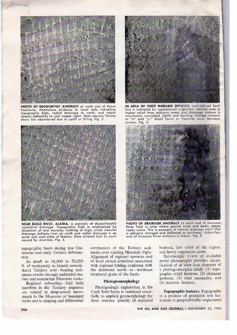
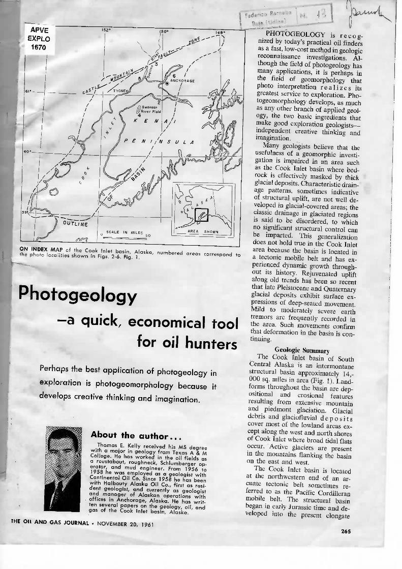
PHOTO OF GEOMORPHIC ANOMALY at north end of KenaiPeninsula. Anomalous evidence is: tonai halo indicatingtopographic hìgh, radiai drainage to north, and majorstream deflection to east (upper right). Note arcuate formershore line abandoned due to uplift or filling. Fig. 2.
NEAR EAGLE RIViR, ALASKA, is example of depositionallycontrolied drainage. Topographic high is emphasized bydissection of end moraine. Looking at high, crude annulardrainage deflects river on north and radiai drainage is onsouth and west sides of feature. Note striated look to northcaused by drumlins. Fig. 4.
IN AREA OF THICK MORAINE DEPOSITS, well-defined faultline is indicated by vegetational alignment. Dashed area ishigher relief than adjacent areas and drainage pattern isstructurally controlled. Uplift and faulting changes streamsat "x" and "y." Small faults or fractures occur betweenarrows. Fig. 3.
PHOTO OF DRAINAGE ANOMALY at south end of SwansonRiver field in area where glacial knob and kettle topog-raphy exists. This is example of normal drainage habit thatis abruptly changed and deflected to southeast. Subsurfaceaxis of Swanson River anticline is shown. Fig. 5.
topographic basin during late Cre-taceous and early Tertiary deforma-tion.
As much as 18,000 to 20,000ft. of moderately to loosely consoli-dated Tertiary coal - bearing sedi-ments overlie strongly indurated ma-rine and nonmarine Mesozoic rocks.
Regional subsurface - fold beltsmanifest in thè Tertiary sequenceare related to deep-seated move-ments in thè Mesozoic or basementrocks and to draping and differential
compaction of thè Tertiary sedi-ments over existing Mesozoic highs.Alignment of regional upwarps andof locai closed anticlines associatedwith regional folding conforms withthè dominant north - to - northeaststructural grain of thè basin.
Photogeomorphology
Photogeologic exploration in thèCook Inlet basin is restricted essen-tially to applied geomorphology forthree reasons: paucity of expected
bedrock, low relief of thè region,and heavy vegetation cover.
Stereoscopie v i e w of availableaerial photographs provides identi-fication of at least four elements ofa photogeomorphic study: (1) topo-graphic relief features, (2) drainagepatterns, (3) total anomalies, and(4) tectonic features.
Topographic features. Topographyis a product of gradation and tec-tonism in geographically unglaciated
266 THE Oli AND GAS JOURNAL • NOVEMBER 20, 1961
'f^ SEOMORPHIC OR DRAINAGE ANOMALY
»' d.c. ind icate* d e p o s i t r o n control ied
1 FAULT LINE
J 'SUBPACE ANTICLINE
«_ FRACTURE TRACE
,yt,«- TONAI. L INEAMENT °i *"i" i
THIS GREAUY REDUCED PHOTOGEOMORPHIC MAP of thè Tyronek area is pre-sented to show thè wealfh of Information that is obtained from photogeologicmaps and Consolidated into a single source. Shown are anticlinal axes, and thèvarious anomalies—both structure controlied and depositional features. Thesealong with faults and fracture trends afford almost complete data on a singlearea. Fig. 6.
areas. The landforms in glaciatedregions of low relief are largely dep-ositional. The problem is to differen-tiate between landforms that are thèresult of deposition and those thatmay bave been influenced by struc-tural uplift.
The dominant surficial featuresof thè Cook I n 1 e t lowlands aremoraine deposits, kame fields andterraces, and outwash. Strutturaicontro! of topographic features isobscured in end moraines but it isfrequently implied in depos i t edground moraine or till cover, i.e.,areas away from thè terminus of aglacier where debris is depositionallyconcentrated. L inear patterns ofhigher ground such as esker ridesand drumlin clusters are difficult tomistake for structural features if thèglacial history of thè basin is wellknown. It is in thè departure fromthè normal relief of a particularlocai or regional area that indica-
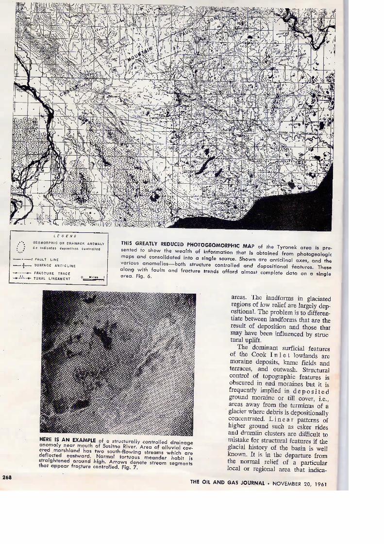
HERE IS AN EXAMPLE of a structurally controlied drainageanomaly near moufh of Susitna River. Area of alluvial cov-ered marshland has two south-flowing streams which aredeflecfed eastward. Normal tortuous meander habit isstraightened around high. Arrows denote stream segmenfsthat appear fracture controlled. Fig. 7.
268 THE OIL AND GAS JOURNAL • NOVEMBER 20, 1961
tions of structural control are ap-parent. Abandoned shore lines (Fig.2), and topography associated withfault lines (Fig. 3) are examples ofchanges in thè norm and are prob-ably related to structural uplift. Itis interesting and possibly signifi-cant that thè only oil field found todate in thè Cook Inlet basin is par-tially located on a broad, till-cov-ered, closed topographic high dis-tinctly visible on t o p o g r a p h i ccontour maps.
Drainage . The courses of thèmany streams and rivers drainingthè basin are strongly influenced byprominent glacial landforms but arenot necessarily controlled. Streampatterns comprising drainage anom-alies may be considered controliedby deposition, controlied partly bydeposition and partly by structure,or controlied by structure. Lithologyis not a significant factor influencingdrainage in thè heterogeneous un-consolidated glacial deposits.
Depositionally controlied drainageis clearly shown in Fig. 4, a verti-cal photograph of thè Eagle Riverarea north of Anchorage, Alaska.The glacial deposits are unmis-takable in thè northwest part of thèphoto, where thè grooved or striatedappearance is established by north-to-northwest-trending drumlin clus-ters. The annular drainage patternformed by thè northerly deflectionof a west-flowing river and south-erly deflection of an abandonedmeli-water channel in thè lower cen-ter of thè photo is influenced bythè topographic high that is part ofa distinct sinuous end moraine.Drainage off thè topographic highis poorly integrated because it isyouthful but a weak radiai patternis beginning to develop. In a laterstage of thè geomorphic cycle, thètopographic remnant will probablycreate a well-defined drainage anom-aly that will be unrelated to struc-tural movement.
Fig. 5 is an aerial photograph ofthè southern part of Swanson Riverfield on thè Kenai Peninsula. Themost prolific producing area occu-pies thè lobate meander in thè upperright of thè p h o t o . The abruptstream deflection and change inchannel characteristics are probablycontrolied by deposition and struc-ture. The course of thè river aroundthè south side of thè glacial land-form (kame?) is depositionally con-
THE FLOW RECORDERYOU CAN COUNT ON
Absolute dependability, under thè most demanding operatingenvironments—that's thè promise and thè performance of thèBarton 202A flow recorder. Thoroughly proven in thè gas pro-duction fieids, thè 202A is enjoying ever-increasing popularityin gas transmission and distribution systems. It is compact andruggedly built, not subject to thè usuai frailties of such a pre-cise instrument; it has built-in overrange protection, and it isimmune to condensate problems, making it ideai for applica-tion in ali geographical areas. A recently added bonus: thè202A con be fitted with thè new Barton chart changer whichallows thè instrument to record continuously and unattended,for up to 16 days, using a fresh chart each day. For completeinfprmation and specifications on thè 202A flow recorder,requestBulletin202A-1.
RECORDER.INTEGRATORS/CONTROLLERS/DIFFERENTIAL PRESSURE INDICATORS/PNEUMATIC TRANSMITTERS/FLOW SWITCHES
BARTON INSTRUMENT CORPORATION • MONTEREY PARK, CALIFORNlA
THE OIL AND GAS JOURNAL • NOVEMBER 20, 1961 269
trolled. Change in meander patternand absence of prominent depo-sitional landforms at thè pointswhere thè river begins its southeast-erly deflection suggest that thè lo-bate m e a n d e r locality has beenslightly uplifted with respect to thèsurrounding surface area.
Well-defined drainage anomalieshave been developed on recent floodplains and tidal flats. Fig. 2 showstwo distinct characteristics of adrainage anomaly: a radiai drain-age on thè recently uplifted or dépo-sitionally filled tide-flat area, and
sharp easterly deflection of a majorstream channel around thè postu-lated uplift. Fig. 7 shows a fiatmarshland adjacent to thè mouth ofthè largest river in thè basin. Thickdeposits of r e c e n t alluvium andtidal-transported silt cover thè area.Abrupt changes in thè direction ofstream flow and changes in meanderhabit on both sides of thè drainageanomaly without apparent topo-graphic, lithologic, or climatic in-fluence suggest structural influence.The geomorphic anomalies in Figs.5 and 7 overlie deep-seated mag-
MAC... Mm-At-Armsfor OILMEN!
As president of Zephyr Drilling for8 years and an officer of thè company nearly20, Mac McClintock, our President, learnedthè oil business from thè "bottom noie" up.And as a director of First National for 11years, he has combined his knowledge of oiland banking in a significant contributionto thè stature and experience of our OilDepartment. Ali this means better oilbanking for you when you . . .
Think.• ili imm- m m»i P | : - -..i;,,-- I : M I I 8 •- • ; • • • - ' .
netic highs which corroborate thèinterpretation of structurally con-trolied drainage.
Tonai anomalies. The relation oftonai differences to structural move-ment is difficult in areas of glacialdeposition because of their abun-dance. A tonai anomaly by defini-tion is any linear, circular, or irreg-ular tonai pattern that differs fromthè surrounding area except thèvariation in shades of gray that isnormally consistent with thè regionalgeology. Pitted outwash, moraines,and poorly drained swamps exhibita variety of mottled photographictones which are not consideredanomalies. The irregular tonai halooutlining thè drainage anomaly inFig. 7 is believed to be unrelatedto thè probable structural uplift inthè area. It appears to have beencaused by tidal action leaving thèarea adjacent to thè stream channelcontinually wet and depositing clayeysilt with each rise of thè tide.
The outstanding halo in Fig. 2 isalso not a tonai anomaly in thèsense that it was created by forcespropagating through thè subcrop.The halo is subaerially created byabnormally high tides onlapping thègrass - covered, subtle topographichigh and depositing layers of graysilt. Here origin is not important;thè tonai contrasts effectively out-line an area of active uplift.
Total differences are useful in de-lineating abandoned meander belts,former shore lines, overlapping mo-raine deposits, and many other geo-morphic features that assist in de-scribing thè recent geologie history.Because thè Cook Inlet basin is ac-tively growing, c h a n g e s in geo-morphic forms may reflect move-ment along subsurface structuraltrends.
Straight tonai bands or lineamentsare common throughout thè basin.These total lineaments may havestructural significance and are dis-cussed below under tectonic fea-tures.
Tectonic features. Fracture tracesand lineaments can be mappedthroughout thè basin even in areaswhere drainage is poorly developed.They are visible in recent morainedeposits, alluvium, and tidal mudflats.
The fracture traces are indicatedby distinct linear-stream segments,
270 THE OIL AND GAS JOURNAL • NOVEMBER 20, 1961
broken vegetational alignments, andnarrow bands of tonai change. Theygenerally conform with thè north-east structural grain of thè basin.Locai significant changes in thè di-rection of fracture traces are asso-ciated with complex faulting oversubsurface anticlinal belts.
Major tonai lineaments and per-sistent sharp vegetational alignmentscan be interpreted as fault lines par-ticularly on thè north and west sidesof thè basin where complex faultingis evident from surface mapping andseismic information. The m a j o rstructural feature of thè northernCook Inlet basin is thè Castle Moun-tain fault zone. The fault zone ismapable on thè outcrop in thè north-east part of thè basin. The zonet r e n d s southwestward along thènorthern perimeter of thè basin asevidenced by isolated granite knobsof Jurassic age that protrude fromthè alluvium and glacial deposits onthè upthrown side of major faults.Well - defined lineaments (Fig. 3)trace and extend thè fault zone overmany miles of alluvium and tillcover where no stratigraphic dis-placement is visible.
Photogeomorpfeic map. The fin-ished produci of a photogeomorphicstudy, as in any geologie investiga-tion, is a map comprising at leastali of thè four geomorphic elementsdiscussed in this text. The map is aparticular type of photogeologicmap wherein geomorphological prin-ciples are stressed in order to showhow earth materials are related tostructural movement.
Fig. 6 is a simplified photogeo-morphic map of thè Tyonek area onthè western side of thè Cook Inletbasin. A recent state competitivelease sale covering 59,000 acres inthè Tyonek area commanded wideattention when thè bonus bid peracre averaged $123. Specific 640-acre tracts were leased for over $900per acre, an assumingly unprece-dented a m o u n t considering verylittle is known about thè subsurfaceTertiary stratigraphy on thè westernside of thè basin. Seismic informa-tion, which prompted thè high bid-ding, obviously indicated that favor-able structural conditions exist.
The glacial overburden in thèmap area has been stripped alongmajor consequent stream valleys.Moderately steep-dipping coal-bear-ing sands and shales of thè Tertiary-
From thè moment you order a Leland truck body . . . its quality-controlled workmanship and diversified applications begin to payoff for you. Look your new Leland body over closely and you'llsee thè Leland difference in durability and reliabiìity.
Tilt trailers . . . welding bodies . . . fifth wheel bodies . . .pole trailers . . . thè Leland "packaged unit" with thè famousTulsa Winch . . . there's a Leland body to fit your particular needs,and Leiand's famous "parts depot" is expertly stocked and staffedto supply you with replacement parts on a moment's notice. Whenand WHERE PERFORMANCE PAYS — Leland is on thè job.
Leiand's truck equipment center offers dump bodies, service, platform and stake bodies . .whatever your needs might be!
ALSO — complete parts and service on Cleveland Trenchers . . . Gardner-Denver . . . C-M-C . .Blaw-Knox . . . Thew-Lorain . . . Bros Road Equipment . . . Tulsa Winches
0/ìC O M P A N Y
C l̂;:.;, . -• «J,M. ./ A
THE OIL AND GAS JOURNAL • NOVEMBER 20, 1901 271
FT./HR.
CONTINUINO RESEARCHPOR LOWER COST DRILLING
FT. DRILLED
3
11
1440
HOURS RUN
2
5
240
FT./HR.
1.5
2.2
6.0
PERFORMANCE DATATYPE
MAKE A, ROCK BIT
MAKE B, ROCK BIT
HYCALOG, DIAMOND PC 91
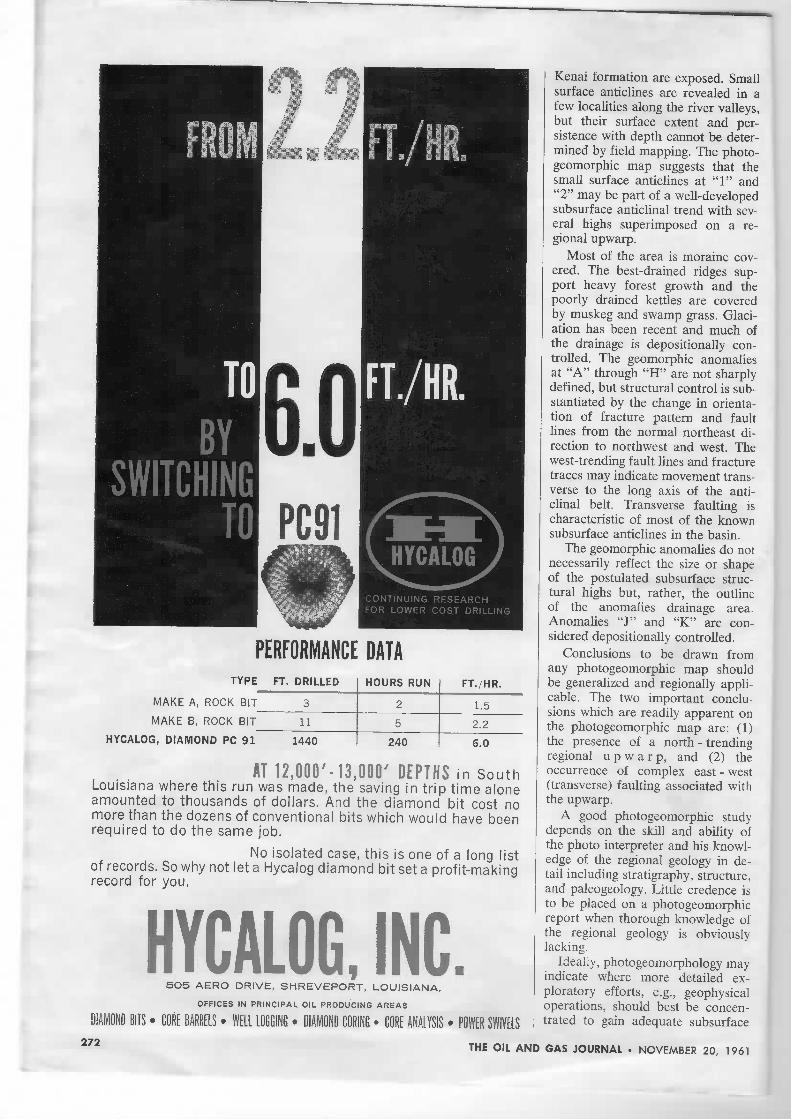
A T R O O O ' - i a . O O O ' D E P T H S i n S o u t hLouisiana where this run was made, thè saving in trip time aloneamounted to thousands of dollars. And thè diamond bit cost nomore than thè dozens of conventional bits which wouid have beenrequired to do thè same job.
No isolated case, this is one of a long listof records. So why not let a Hycalog diamond bit set a profit-makingrecord for you.
HYCALOG, INC.5O5 AERO DRIVE, SHREVEPORT, LOUISIANA.
OFFICES IN PRINCIPAL OIL PRODUCINE AREAS
DIAMOND BUS • GORE BARRELS • WELL LOGGING • DIAMOND CORINE • GORE ANALYSIS • POWER SWIVELS
Kenai formatici! are exposed. Smallsurface anticlines are revealed in afew localities along thè river valleys,but their surface extent and per-sistence with depth cannot be deter-mined by field mapping. The photo-geomorphic map suggests that thèsmall surface anticlines at "1" and"2" may be part of a well-developedsubsurface anticlinal trend with sev-eral highs superimposed on a re-gional upwarp.
Most of thè area is moraine cov-ered. The best-drained ridges sup-port heavy foresi growth and thèpoorly drained kettles are coveredby muskeg and swamp grass. Glaci-ation has been recent and much ofthè drainage is depositionally con-trolled. The geomorphic anomaliesat "A" through "H" are not sharplydefined, but structural contro! is sub-stantiated by thè change in orienta-tion of fracture pattern and faultlines from thè normal northeast di-rection to northwest and west. Thewest-trending fault lines and fracturetraces may indicate movement trans-verse to thè long axis of thè anti-clinal belt. Transverse faulting ischaracteristic of most of thè knownsubsurface anticlines in thè basin.
The geomorphic anomalies do notnecessarily reflect thè size or shapeof thè postulated subsurface struc-tural highs but, rather, thè outlineof thè anomalies drainage area.Anomalies "J" and "K" are con-sidered depositionally controlied.
Conclusions to be drawn fromany photogeomorphic map shouldbe generalized and regionally appli-cable. The two important conclu-sions which are readily apparent onthè photogeomorphic map are: (1)thè presence of a north - trendingregional u p w a r p , and (2) thèoccurrence of complex cast - west(transverse) faulting associated withthè upwarp.
A good photogeomorphic studydepends on thè skill and ability ofthè photo interpreter and bis knowl-edge of thè regional geology in de-tail including stratigraphy, structure,and paleogeology. Little credence isto be placed on a photogeomorphicreport when thorough knowledge ofthè regional geology is obviouslylacking.
Ideally, photogeomorphology mayindicate where more detailed ex-ploratory efforts, e.g., geophysicaloperations, should best be concen-trated to gain adequate subsurface
272 THE OIL AND GAS JOURNAL • NOVEMBER 20, 1961
youm thè
adtest moniti
fitstill-new line ofSpechi Patpose M/outes'm 25Por a reprint of this ad and additional Information pleasewrite thè factory or contact your Nelson representative.
TULSA, OKLAHOMA
P. O. BOX 5385 NATIONAL 7-553O
274
information for thè least time andmoney.
BibliographyAmerican Society of Photogrammetry,
"Marmai of Photographic Interpretation,"pp. 169-296, 1960.
Kelly, T. E., "General Geology and Hy-drocarbons in thè Cook Inlet Basin, Alaska,"AAPG Special Volume Symposium (in pub-lication).
Lattman, L. H., "Geomorphology: NewTool for Finding Oil," The Oil and GasJournal, Voi. 59, No. 18, pp. 231-236, 1959.
Miller, R. D., and Dobrovolny, Ernest,"Surficial Geology of Anchorage and Vicin-ity, Alaska," USGS Bui!. 1093, 1959.
Alberta oil huntingsets fast pace
REEF EXPLORATION is onthè upswing in thè Buffalo Lake-Bashaw area in Alberta's centraifairway. Four wildcats are alreadydrilling with two more planned soon.Present wells are centered at BuffaloLake, 10-15 miles north of im-portant D3 zone of Devonian oilreserves at Erskine. The other wellsare reportedly north of thè currentwildcats.
Several factors. Three drillingreservations in thè area are up forsale by thè Alberta government No-vember 23-December 5.
As most of thè leases in this par-ticular area—70 miles southeast ofEdmonton and 140 miles northeastof Calgary—were taken out duringthè extensive Alberta Plains oil playin thè early 50's, 10-year leases arerunning out. Thus it is drill andevaluate now, release, or re-lease.
Some of thè major acreage hold-ers are drilling while others are par-ticipating in thè present play throughland contributions. Either way thèfast evaluation of a sizable spreadof acreage is under way. The areahas been a hot spot for geophysicalexploration in thè past number ofmonths and as soon as further pre-liminary exploration of this type iscompleted by one operator definitedrilling plans will be announced.
Buffalo Lake. California Stand-ard Co. is drilling a pair of testshere. Tenneco Oil Co. recently be-gan drilling at a wildcat here, andImperiai Oil Ltd. is drilling northof Nevis gas field D3 zone nearBuffalo Lake.
The first test in this current playwas Tenneco Oil Co. 1-A BuffaloLake,, LSD 11, 13-41-21w4. Thistest will try for production down
THE OIL AND GIS JOURNAL • NOVEMBER 20, 1961