Embed Size (px)
Citation preview
Nat. Hazards Earth Syst. Sci., 11, 1589–1597, 2011www.nat-hazards-earth-syst-sci.net/11/1589/2011/doi:10.5194/nhess-11-1589-2011© Author(s) 2011. CC Attribution 3.0 License.
Natural Hazardsand Earth
System Sciences
Physical and numerical modelling of a bedload deposition area foran Alpine torrent
R. Kaitna1, M. Chiari 1, M. Kerschbaumer1,*, H. Kapeller1,** , J. Zlatic-Jugovic1,*** , M. Hengl2, and J. Huebl1
1Institute of Mountain Risk Engineering, University of Natural Resources and Life Sciences, Vienna, Austria2Federal Agency for Water Management, Vienna, Austria* now at: Austrian Service for Torrent and Avalanche Control, Austria** now at: Umweltbuero Engineers, Austria*** now at: International Sava River Basin Commission (ISRBC), Zagreb, Croatia
Received: 17 November 2010 – Revised: 22 April 2011 – Accepted: 28 April 2011 – Published: 1 June 2011
Abstract. Floods including intensive bedload transport rep-resent a severe hazard to the often densely populated alluvialfans of small Alpine watersheds. In order to minimize therisk of future inundation, an existing bedload deposition areaon the fan upstream of the village Vorderberg in southernAustria is planned for reconstruction. The suggested con-cept for protection measures includes dividing the area intothree similar sections of reduced slope. The three sectionsare to be separated by a block ramp. To test this conceptand to optimize the sedimentation process, an analysis wasperformed by using both a physical scale model (1:30) anda numerical simulation tool (SETRAC). Four configurationsfor the section-outlet were tested based on three flood sce-narios. The results support the general protection conceptand suggest a minimum construction configuration, includ-ing a woody debris filter. Employing a physical scale modelfor analysing small watershed processes is rarely found inliterature. This contribution represents an applied study andprovides quantitative information on bedload deposition andoutflow from a deposition area. We test a novel simulationtool for bedload transport on the steep slopes against the mea-surements in the laboratory and show that the combination ofphysical and numerical modelling is a valuable tool to eval-uate the efficiency of planned measures for torrent hazardmitigation.
Correspondence to:R. Kaitna([email protected])
1 Introduction
On 29 August 2003 a flood event hit the village of Vorder-berg/St. Stefan, Austria, causing severe damage to severalhouses on the fan of the creek “Vorderbergerbach” (Fig. 1).A total of 285 mm rainfall has been estimated by the Hy-drological Service of Austria. The back-calculated peak dis-charge of 120 m3 s−1 corresponds to a design peak dischargeof an approximate 100-yr return period. The elevated waterlevel in the channel resulted in significant bed erosion, bankerosion and in the undercutting of adjacent hill slopes in theupper parts, as well as in the middle part of the watershed.Sediment availability for torrential processes has additionallybeen fostered by small scale shallow landslides with slip sur-faces on the interface between bedrock (limestone and schist)and the quaternary sediment in the upper reaches of the tor-rent. During the course of a detailed event documentation(Huebl et al., 2004), sediment budgeting resulted in a totalvolume of about 450 000 m3 of eroded sediment in the chan-nel and adjacent to the channel. Around 200 000 m3 were de-posited within the channel system and upstream of the checkdams in the lower transit reach of the creek. 250 000 m3 ofsediment, including some 50 000 to 80 000 m3 of bedload,were delivered to the fan. Unfortunately no quantitative as-sessment of woody debris recruitment and transport to thefan is available. However, due to limited channel capacityand woody debris blockages at bridges, the village Vorder-berg was flooded; sediment was deposited outside of thechannel and was only partially delivered to the receiving riverGail.
Published by Copernicus Publications on behalf of the European Geosciences Union.
1590 R. Kaitna et al.: Physical and numerical modelling of a bedload deposition area for an alpine torrent
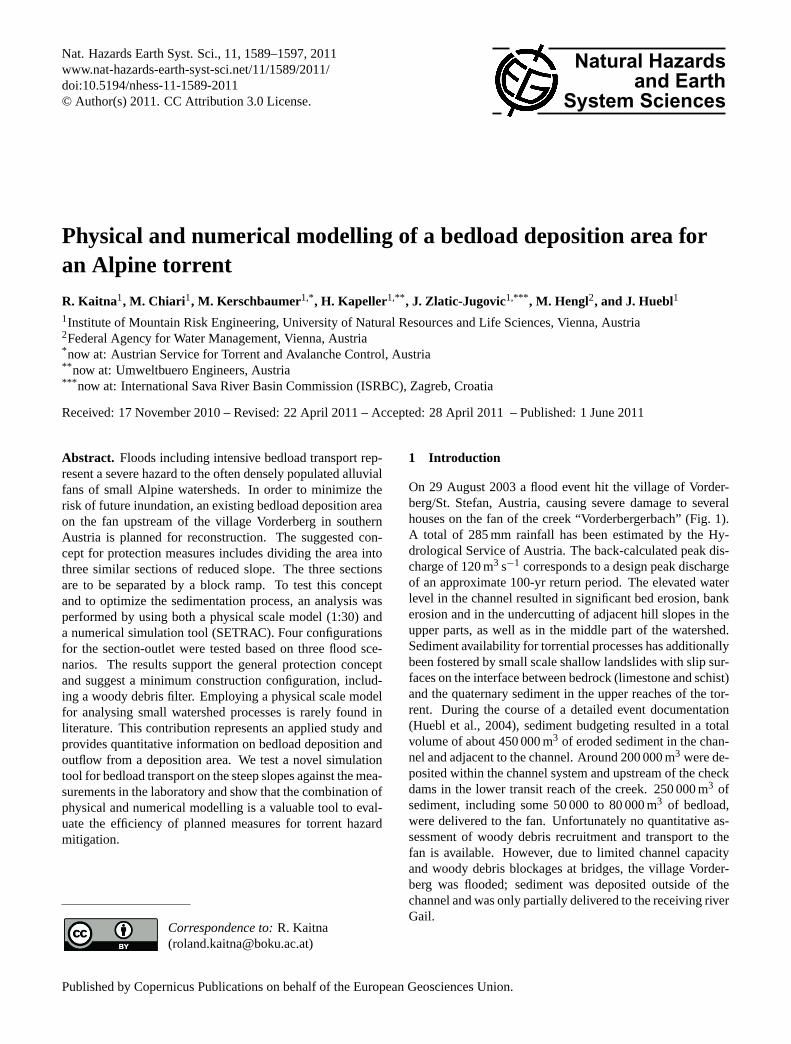
Fig. 1. Overview of the study catchment and its location in Austria.
In order to protect the village from future inundation, theexisting bedload deposition area upstream of the settlementis going to be modified by local authorities. The objectiveof this study is to elaborate a general concept for the re-structuring of the retention area, to analyse the depositionprocess and to optimize the sedimentation capacity of theretention basin by means of a physical scale model (Hueblet al., 2007) and a numerical simulation tool. These typesof applied studies for small watersheds are rare in engineer-ing practice as well as in literature. We present continuousmeasurements of the deposition process for different hydro-logic scenarios, three-dimensional deposition pattern result-ing from three constructive measures to enhance the deposi-tion process, as well as a comparison with a novel numericalsimulation tool to model bedload transport and deposition insteep channels.
2 General concept of protection measures
The existing retention area has a length of around 530 m anda width varying between 40 and 80 m. The average slope isaround 2 %. Based on suggestions of Zollinger (1983) for thedesign of retention basins, three approaches of restructuringmeasures are under consideration and were evaluated by thisproject:
– The deposition area is widened as far as property linesare not affected. This measure is expected to have twoeffects: first, the bedload discharge will be reducedsince the transport capacity is also a function of channelwidth (Jaeggi, 1992). Secondly, the potential depositionvolume is increased.
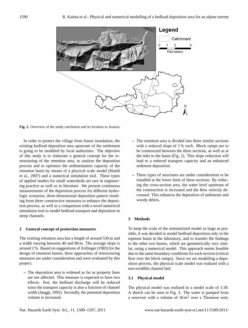
– The retention area is divided into three similar sectionswith a reduced slope of 1 % each. Block ramps are tobe constructed between the three sections, as well as atthe inlet to the basin (Fig. 2). This slope reduction willlead to a reduced transport capacity and an enhancedsediment deposition.
– Three types of structures are under consideration to beinstalled at the lower limit of these sections. By reduc-ing the cross-section area, the water level upstream ofthe construction is increased and the flow velocity de-creased. This enhances the deposition of sediments andwoody debris.
3 Methods
To keep the scale of the miniaturized model as large as pos-sible, it was decided to model bedload deposition only in thetopmost basin in the laboratory, and to transfer the findingsto the other two basins, which are geometrically very simi-lar, using a numerical model. This approach seems feasibledue to the same boundary conditions for each section (criticalflow over the block ramps). Since we are modelling a depo-sition process, the physical scale model was realized with anon-erodible channel bed.
3.1 Physical model
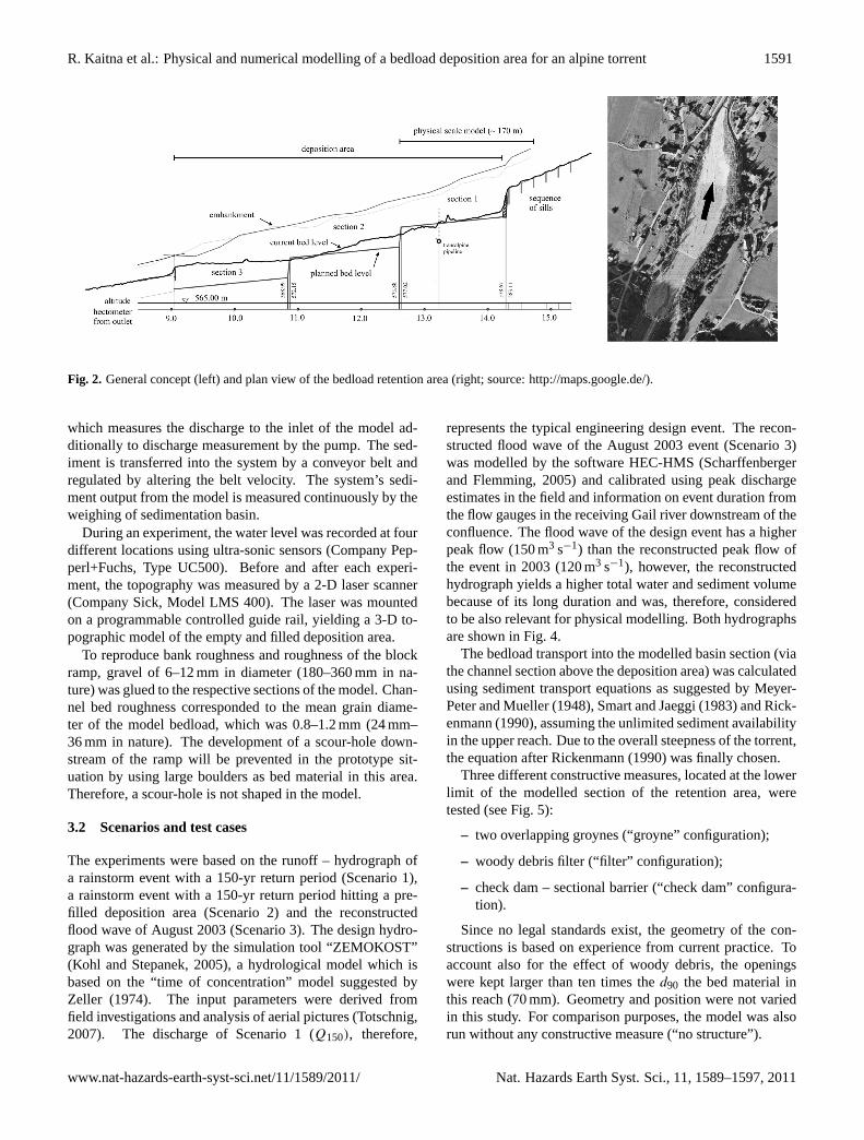
The physical model was realized in a model scale of 1:30.A sketch can be seen in Fig. 3. The water is pumped froma reservoir with a volume of 36 m3 over a Thomson weir,
Nat. Hazards Earth Syst. Sci., 11, 1589–1597, 2011 www.nat-hazards-earth-syst-sci.net/11/1589/2011/
R. Kaitna et al.: Physical and numerical modelling of a bedload deposition area for an alpine torrent 1591
Fig. 2. General concept (left) and plan view of the bedload retention area (right; source:http://maps.google.de/).
which measures the discharge to the inlet of the model ad-ditionally to discharge measurement by the pump. The sed-iment is transferred into the system by a conveyor belt andregulated by altering the belt velocity. The system’s sedi-ment output from the model is measured continuously by theweighing of sedimentation basin.
During an experiment, the water level was recorded at fourdifferent locations using ultra-sonic sensors (Company Pep-perl+Fuchs, Type UC500). Before and after each experi-ment, the topography was measured by a 2-D laser scanner(Company Sick, Model LMS 400). The laser was mountedon a programmable controlled guide rail, yielding a 3-D to-pographic model of the empty and filled deposition area.
To reproduce bank roughness and roughness of the blockramp, gravel of 6–12 mm in diameter (180–360 mm in na-ture) was glued to the respective sections of the model. Chan-nel bed roughness corresponded to the mean grain diame-ter of the model bedload, which was 0.8–1.2 mm (24 mm–36 mm in nature). The development of a scour-hole down-stream of the ramp will be prevented in the prototype sit-uation by using large boulders as bed material in this area.Therefore, a scour-hole is not shaped in the model.
3.2 Scenarios and test cases
The experiments were based on the runoff – hydrograph ofa rainstorm event with a 150-yr return period (Scenario 1),a rainstorm event with a 150-yr return period hitting a pre-filled deposition area (Scenario 2) and the reconstructedflood wave of August 2003 (Scenario 3). The design hydro-graph was generated by the simulation tool “ZEMOKOST”(Kohl and Stepanek, 2005), a hydrological model which isbased on the “time of concentration” model suggested byZeller (1974). The input parameters were derived fromfield investigations and analysis of aerial pictures (Totschnig,2007). The discharge of Scenario 1 (Q150), therefore,
represents the typical engineering design event. The recon-structed flood wave of the August 2003 event (Scenario 3)was modelled by the software HEC-HMS (Scharffenbergerand Flemming, 2005) and calibrated using peak dischargeestimates in the field and information on event duration fromthe flow gauges in the receiving Gail river downstream of theconfluence. The flood wave of the design event has a higherpeak flow (150 m3 s−1) than the reconstructed peak flow ofthe event in 2003 (120 m3 s−1), however, the reconstructedhydrograph yields a higher total water and sediment volumebecause of its long duration and was, therefore, consideredto be also relevant for physical modelling. Both hydrographsare shown in Fig. 4.
The bedload transport into the modelled basin section (viathe channel section above the deposition area) was calculatedusing sediment transport equations as suggested by Meyer-Peter and Mueller (1948), Smart and Jaeggi (1983) and Rick-enmann (1990), assuming the unlimited sediment availabilityin the upper reach. Due to the overall steepness of the torrent,the equation after Rickenmann (1990) was finally chosen.
Three different constructive measures, located at the lowerlimit of the modelled section of the retention area, weretested (see Fig. 5):
– two overlapping groynes (“groyne” configuration);
– woody debris filter (“filter” configuration);
– check dam – sectional barrier (“check dam” configura-tion).
Since no legal standards exist, the geometry of the con-structions is based on experience from current practice. Toaccount also for the effect of woody debris, the openingswere kept larger than ten times thed90 the bed material inthis reach (70 mm). Geometry and position were not variedin this study. For comparison purposes, the model was alsorun without any constructive measure (“no structure”).
www.nat-hazards-earth-syst-sci.net/11/1589/2011/ Nat. Hazards Earth Syst. Sci., 11, 1589–1597, 2011
1592 R. Kaitna et al.: Physical and numerical modelling of a bedload deposition area for an alpine torrent
Fig. 3. Sketch (left) and picture (right) of the physical model.
Fig. 4. Model hydrographs (solid line: Scenario 1 and 2, dashedline: Scenario 3).
3.3 Scaling considerations and calibration
In order to transfer all processes and observations frommodel to prototype (nature), geometric, kinematic and dy-namic similarity has to be fulfilled (Preissler et al., 1989).However, the condition of full dynamic similarity (i.e., di-mensionless numbers like Froude number and Reynoldsnumber in the model have to equal the numbers that hold fornature), cannot be fulfilled when ‘natural water’ is used in themodel. In open channel flow, the flowing medium is water,which has a very low Newtonian viscosity. Hence, for turbu-lent flow regime (found in most open channel flows) fulfillingFroude similarity (accounting for inertial and gravity forcesand neglecting viscous forces) yields satisfying results. In or-der to keep unavoidable errors small (especially in sedimenttransport), the geometrical scaling factor was kept as small
as possible (i.e., the physical model was performed as largeas possible). The geometric scale for the model “Vorderberg-erbach” was chosen to equal 1:30.
The physical modelling of sediment transport is problem-atic when the cohesive forces between scaled particles be-come relevant. For these cases, alternative material of largergrain size and smaller density is preferred. The grain sizeanalysis (surface sampling after Fehr, 1987) of the bedloadmaterial from the Vorderbergerbach Creek revealed a rela-tively narrow grain size distribution, with ad50 of 23 mm andad90 of 70 mm. The corresponding model values are 0.8 mmand 2.3 mm, respectively. For these grain sizes, no cohesiveforce effects were expected. For practical reasons, we had torestrict our model sediment to a less wide grain size distribu-tion with ad50 of 1.3 mm and ad90 of 1.9 mm. This seemsjustified because we aim to compare different scenarios andhave no detailed information on grain sizes during the floodevent.
Because of the lack of in situ water level and flow velocitymeasurements (which are generally rare in torrents), modelroughness was calibrated by numerical simulation of steadyflow at several clear water discharges. Using the 1-D hy-drodynamic model HEC-RAS (Brunner, 2010), we modelledwater surface profiles in sub-critical, supercritical and mixedflow regime. Manning coefficients of 0.038 m−0.33 s and0.05 m−0.33 s were used for the channel and for the banks,respectively, which is realistic for a creek. The comparisonof flow depth measured with ultra-sonic sensors and meanvelocity measured with a hydrometric vane revealed a max-imum difference between the physical and numerical modelof around 10 %. Table 1 exemplarily gives an overview ofvalues calculated and measured at a section half-way be-tween the inlet and the outlet of the physical model. Sincewe are mainly interested in the relative difference of the givenscenarios, this correspondence was accepted as reasonable.
Nat. Hazards Earth Syst. Sci., 11, 1589–1597, 2011 www.nat-hazards-earth-syst-sci.net/11/1589/2011/
R. Kaitna et al.: Physical and numerical modelling of a bedload deposition area for an alpine torrent 1593
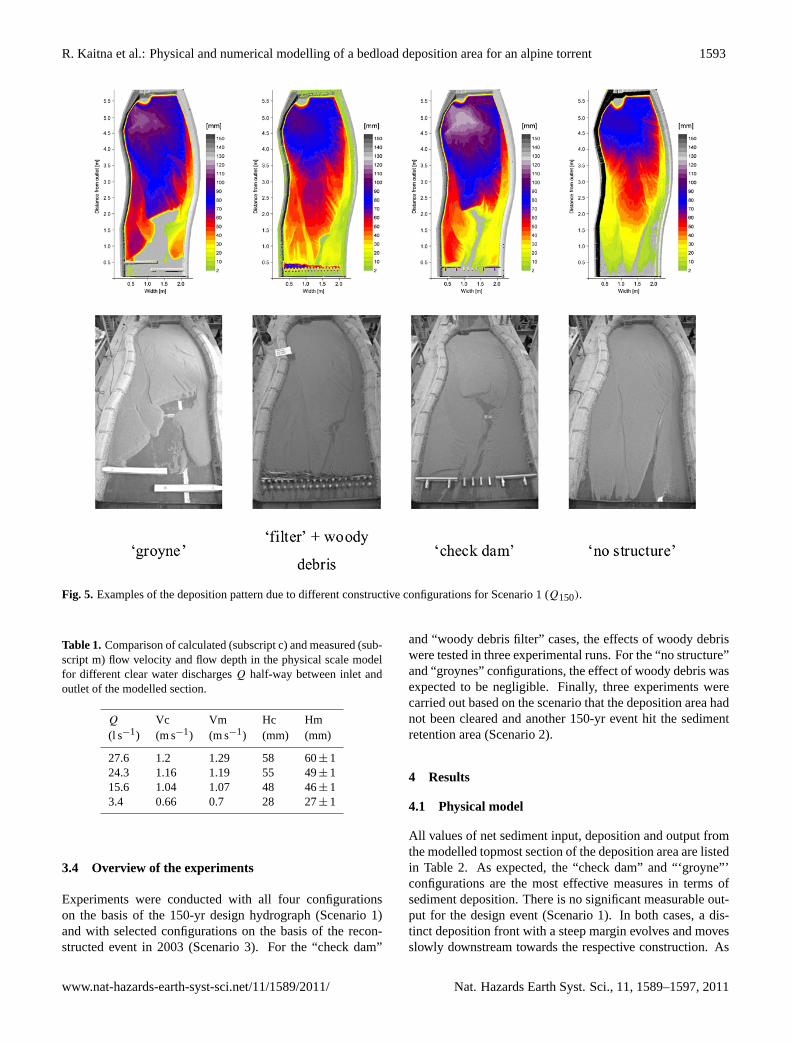
Fig. 5. Examples of the deposition pattern due to different constructive configurations for Scenario 1 (Q150).
Table 1. Comparison of calculated (subscript c) and measured (sub-script m) flow velocity and flow depth in the physical scale modelfor different clear water dischargesQ half-way between inlet andoutlet of the modelled section.
Q Vc Vm Hc Hm(l s−1) (m s−1) (m s−1) (mm) (mm)
27.6 1.2 1.29 58 60± 124.3 1.16 1.19 55 49± 115.6 1.04 1.07 48 46± 13.4 0.66 0.7 28 27± 1
3.4 Overview of the experiments
Experiments were conducted with all four configurationson the basis of the 150-yr design hydrograph (Scenario 1)and with selected configurations on the basis of the recon-structed event in 2003 (Scenario 3). For the “check dam”
and “woody debris filter” cases, the effects of woody debriswere tested in three experimental runs. For the “no structure”and “groynes” configurations, the effect of woody debris wasexpected to be negligible. Finally, three experiments werecarried out based on the scenario that the deposition area hadnot been cleared and another 150-yr event hit the sedimentretention area (Scenario 2).
4 Results
4.1 Physical model
All values of net sediment input, deposition and output fromthe modelled topmost section of the deposition area are listedin Table 2. As expected, the “check dam” and “‘groyne”’configurations are the most effective measures in terms ofsediment deposition. There is no significant measurable out-put for the design event (Scenario 1). In both cases, a dis-tinct deposition front with a steep margin evolves and movesslowly downstream towards the respective construction. As
www.nat-hazards-earth-syst-sci.net/11/1589/2011/ Nat. Hazards Earth Syst. Sci., 11, 1589–1597, 2011
1594 R. Kaitna et al.: Physical and numerical modelling of a bedload deposition area for an alpine torrent
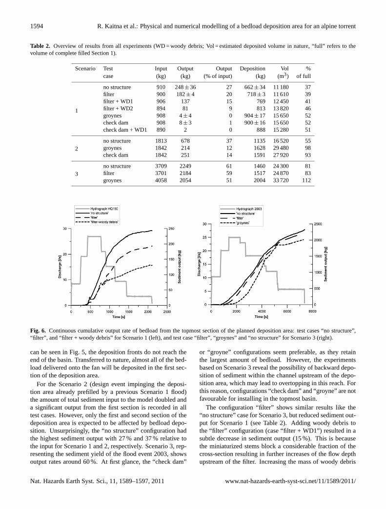
Table 2. Overview of results from all experiments (WD = woody debris; Vol = estimated deposited volume in nature, “full” refers to thevolume of complete filled Section 1).
Scenario Test Input Output Output Deposition Vol %case (kg) (kg) (% of input) (kg) (m3) of full
1
no structure 910 248± 36 27 662± 34 11 180 37filter 900 182± 4 20 718± 3 11 610 39filter + WD1 906 137 15 769 12 450 41filter + WD2 894 81 9 813 13 820 46groynes 908 4± 4 0 904± 17 15 650 52check dam 908 8± 3 1 900± 16 15 650 52check dam + WD1 890 2 0 888 15 280 51
2no structure 1813 678 37 1135 16 520 55groynes 1842 214 12 1628 29 480 98check dam 1842 251 14 1591 27 920 93
3no structure 3709 2249 61 1460 24 300 81filter 3701 2184 59 1517 24 870 83groynes 4058 2054 51 2004 33 720 112
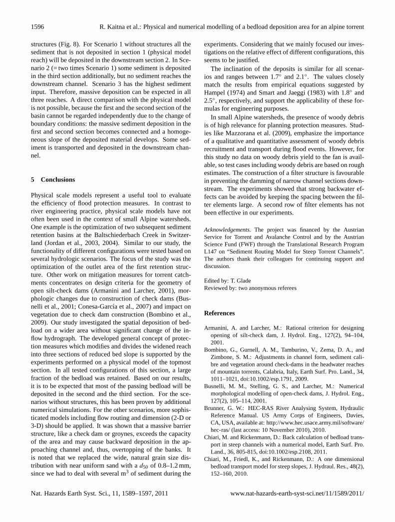
Fig. 6. Continuous cumulative output rate of bedload from the topmost section of the planned deposition area: test cases “no structure”,“filter”, and “filter + woody debris” for Scenario 1 (left), and test case “filter”, “groynes” and “no structure” for Scenario 3 (right).
can be seen in Fig. 5, the deposition fronts do not reach theend of the basin. Transferred to nature, almost all of the bed-load delivered onto the fan will be deposited in the first sec-tion of the deposition area.
For the Scenario 2 (design event impinging the deposi-tion area already prefilled by a previous Scenario 1 flood)the amount of total sediment input to the model doubled anda significant output from the first section is recorded in alltest cases. However, only the first and second section of thedeposition area is expected to be affected by bedload depo-sition. Unsurprisingly, the “no structure” configuration hadthe highest sediment output with 27 % and 37 % relative tothe input for Scenario 1 and 2, respectively. Scenario 3, rep-resenting the sediment yield of the flood event 2003, showsoutput rates around 60 %. At first glance, the “check dam”
or “groyne” configurations seem preferable, as they retainthe largest amount of bedload. However, the experimentsbased on Scenario 3 reveal the possibility of backward depo-sition of sediment within the channel upstream of the depo-sition area, which may lead to overtopping in this reach. Forthis reason, configurations “check dam” and “groyne” are notfavourable for installing in the topmost basin.
The configuration “filter” shows similar results like the“no structure” case for Scenario 3, but reduced sediment out-put for Scenario 1 (see Table 2). Adding woody debris tothe “filter” configuration (case “filter + WD1”) resulted in asubtle decrease in sediment output (15 %). This is becausethe miniaturized stems block a considerable fraction of thecross-section resulting in further increases of the flow depthupstream of the filter. Increasing the mass of woody debris
Nat. Hazards Earth Syst. Sci., 11, 1589–1597, 2011 www.nat-hazards-earth-syst-sci.net/11/1589/2011/

R. Kaitna et al.: Physical and numerical modelling of a bedload deposition area for an alpine torrent 1595
(case “filter + WD2”) yields a further decrease of relativesediment output (9 %). A comparison of the continuous out-put is shown in Fig. 6 (right).
4.2 Numerical model
A novel 1-D sediment routing model for steep torrent chan-nel networks, called SETRAC (Chiari et al., 2010; Chiariand Rickenmann, 2011) has been tested to simulate physi-cal model results on the first section of the deposition areaand to predict bedload deposition in subsequent sections.SETRAC is the acronym forSedimentTr ansport Model inAlpine Catchments. Different sediment transport formulasand flow resistance approaches can be selected for specialapplication in steep channels. To take form roughness lossesinto account, several approaches are available to modify thecalculated transport capacity to better match observations onbedload transport. Armouring effects can also be consid-ered. Additionally, it is possible to calculate fractional bed-load transport and to consider grain sorting effects in combi-nation with mobile bed conditions. In SETRAC the channelnetwork is represented by nodes, cross-sections and sections.Sediment is transferred through the channel network consid-ering a pre-defined sediment budget in the sections. Initialerosion depth can be assigned for each channel reach andmorphologic changes due to erosion and deposition are cal-culated. A graphical user interface with visualizations of thelongitudinal sections, as well as the cross-sections, has beendeveloped. For the calculation, each cross-section is dividedinto strips to get a representative discretization of the profile.The number of strips depends on the number of points thatare used to specify a cross-section, implying that the numberof strips increases with the complexity of the cross-section.Flow hydrographs are routed as kinematic waves through thechannel system. Sediment input as sedi-graphs is also possi-ble. The successor of the SETRAC model (TomSed) as wellas a user manual and tutorials are available as a free down-load atwww.bedload.at.
The physical scale model covers only the upper third of theinvestigation area. Therefore, the numerical model has beenapplied for the scenarios without structures to expand the in-formation on bedload deposition in the downstream sections.For calibration the deposition in the first section has beentaken as reference. To get a better representation of the 2-D deposition pattern, the average lateral deposition heightswere determined at cross-sections with a distance of 25 cmin a longitudinal direction. The deposition heights, result-ing from the simulation by SETRAC, were compared to theaverage deposition of the physical model.
The spatial discretization for the SETRAC simulation was0.1 m. In SETRAC the flow velocity was calculated basedon the formula suggested by Smart and Jaeggi (1983) andthe bedload transport using Rickenmann’s (1990) formula,where the incipient motion conditionθcr served as a calibra-tion parameter (θcr = 0.046). Figure 7 shows a comparison of
Fig. 7. Comparison of modelled (SETRAC) and measured deposi-tion heights for Scenario 1 and the no structure configuration.
Fig. 8. SETRAC model simulation results for the whole depositionarea (distance 6 m–23 m) for Scenario 1, 2, and 3 – without struc-tures.
the measured mean cross-sectional deposition height in thephysical model and the SETRAC simulation for Scenario 1(no structure). In the physical model, only the first section ofthe whole deposition area was modelled. The calibrated sim-ulation of Scenario 1 without structures allows the predictingof the depositional behaviour in the other sections. The de-position behaviour, as well as the slope of the deposited ma-terial, could be modelled accurately with the exception of thescour close to the inlet of the basin, which could not be re-produced by the simplified hydraulics of the SETRAC model(Fig. 7).
With SETRAC all three depositional sections, as well asthe planned channel downstream of the depositional area,have been simulated for Scenarios 1, 2 and 3 without
www.nat-hazards-earth-syst-sci.net/11/1589/2011/ Nat. Hazards Earth Syst. Sci., 11, 1589–1597, 2011
1596 R. Kaitna et al.: Physical and numerical modelling of a bedload deposition area for an alpine torrent
structures (Fig. 8). For Scenario 1 without structures all thesediment that is not deposited in section 1 (physical modelreach) will be deposited in the downstream section 2. In Sce-nario 2 (= two times Scenario 1) some sediment is depositedin the third section additionally, but no sediment reaches thedownstream channel. Scenario 3 has the highest sedimentinput. Therefore, massive deposition can be expected in allthree reaches. A direct comparison with the physical modelis not possible, because the first and the second section of thebasin cannot be regarded independently due to the change ofboundary conditions: the massive sediment deposition in thefirst and second section becomes connected and a homoge-neous slope of the deposited material develops. Some sed-iment is transported and deposited in the downstream chan-nel.
5 Conclusions
Physical scale models represent a useful tool to evaluatethe efficiency of flood protection measures. In contrast toriver engineering practice, physical scale models have notoften been used in the context of small Alpine watersheds.One example is the optimization of two subsequent sedimentretention basins at the Baltschiederbach Creek in Switzer-land (Jordan et al., 2003, 2004). Similar to our study, thefunctionality of different configurations were tested based onseveral hydrologic scenarios. The focus of the study was theoptimization of the outlet area of the first retention struc-ture. Other work on mitigation measures for torrent catch-ments concentrates on design criteria for the geometry ofopen silt-check dams (Armanini and Larcher, 2001), mor-phologic changes due to construction of check dams (Bus-nelli et al., 2001; Conesa-Garcıa et al., 2007) and impact onvegetation due to check dam construction (Bombino et al.,2009). Our study investigated the spatial deposition of bed-load on a wider area without significant change of the in-flow hydrograph. The developed general concept of protec-tion measures which modifies and divides the widened reachinto three sections of reduced bed slope is supported by theexperiments performed on a physical model of the topmostsection. In all tested configurations of this section, a largefraction of the bedload was retained. Based on our results,it is to be expected that most of the passing bedload will bedeposited in the second and the third section. For the sce-narios without structures, this has been proven by additionalnumerical simulations. For the other scenarios, more sophis-ticated models including flow routing and dimension (2-D or3-D) should be applied. It was shown that a massive barrierstructure, like a check dam or groynes, exceeds the capacityof the area and may cause backward deposition in the ap-proaching channel and, thus, overtopping of the banks. Itis noted that we replaced the wide, natural grain size dis-tribution with near uniform sand with ad50 of 0.8–1.2 mm,since we had to deal with several m3 of sediment during the
experiments. Considering that we mainly focused our inves-tigations on the relative effect of different configurations, thisseems to be justified.
The inclination of the deposits is similar for all scenar-ios and ranges between 1.7◦ and 2.1◦. The values closelymatch the results from empirical equations suggested byHampel (1974) and Smart and Jaeggi (1983) with 1.8◦ and2.5◦, respectively, and support the applicability of these for-mulas for engineering purposes.
In small Alpine watersheds, the presence of woody debrisis of high relevance for planning protection measures. Stud-ies like Mazzorana et al. (2009), emphasize the importanceof a qualitative and quantitative assessment of woody debrisrecruitment and transport during flood events. However, forthis study no data on woody debris yield to the fan is avail-able, so test cases including woody debris are based on roughestimates. The construction of a filter structure is favourablein preventing the damming of narrow channel sections down-stream. The experiments showed that strong backwater ef-fects can be avoided by keeping the spacing between the fil-ter elements large. A second row of filter elements has notbeen effective in our experiments.
Acknowledgements.The project was financed by the AustrianService for Torrent and Avalanche Control and by the AustrianScience Fund (FWF) through the Translational Research ProgramL147 on “Sediment Routing Model for Steep Torrent Channels”.The authors thank their colleagues for continuing support anddiscussion.
Edited by: T. GladeReviewed by: two anonymous referees
References
Armanini, A. and Larcher, M.: Rational criterion for designingopening of silt-check dam, J. Hydrol. Eng., 127(2), 94–104,2001.
Bombino, G., Gurnell, A. M., Tamburino, V., Zema, D. A., andZimbone, S. M.: Adjustments in channel form, sediment cali-bre and vegetation around check-dams in the headwater reachesof mountain torrents, Calabria, Italy, Earth Surf. Pro. Land., 34,1011–1021,doi:10.1002/esp.1791, 2009.
Busnelli, M. M., Stelling, G. S., and Larcher, M.: Numericalmorphological modelling of open-check dams, J. Hydrol. Eng.,127(2), 105–114, 2001.
Brunner, G. W.: HEC-RAS River Analysing System, HydraulicReference Manual. US Army Corps of Engineers, Davies,CA, USA, available at:http://www.hec.usace.army.mil/software/hec-ras/(last access: 10 November 2010), 2010.
Chiari, M. and Rickenmann, D.: Back calculation of bedload trans-port in steep channels with a numerical model, Earth Surf. Pro.Land., 36, 805-815,doi:10.1002/esp.2108, 2011.
Chiari, M., Friedl, K., and Rickenmann, D.: A one dimensionalbedload transport model for steep slopes, J. Hydraul. Res., 48(2),152–160, 2010.
Nat. Hazards Earth Syst. Sci., 11, 1589–1597, 2011 www.nat-hazards-earth-syst-sci.net/11/1589/2011/
R. Kaitna et al.: Physical and numerical modelling of a bedload deposition area for an alpine torrent 1597
Conesa-Garcıa, C., Lopez-Bermudes, F., and Garcıa-Lorenzo, R.:Bed stability variations after check dam construction in torrentialchannels (South-East Spain), Earth Surf. Pro. Land., 32, 2165–2184, 2007.
Fehr, R.: Geschiebeanalysen in Gebirgsfluessen, Umrechnung undVergleich von verschiedenen Analyseverfahren, Mitteilung derVersuchsanstalt fuer Wasserbau, Hydrologie und Glaziologie,ETH Zuerich, 92, 1987.
Hampel, R.: Die Wirkungsweise von Wildbachsperren, Oesterre-ichische Wasserwirtschaft, 11/12, 265–273, 1974.
Huebl, J., Leber, D., Brauner, M., Janu, S., Volk, G., Holzinger, H.,and Gruber, H.: WLS Report 99: Dokumentation der Unwetter-ereignisse in den Gemeinden St. Stefan/Vorderberg und Feistritzan der Gail vom 29. August 2003, Institute of Mountain RiskEngineering, Boku University Vienna, Austria (unpublished re-port), 2004.
Huebl, J., Kaitna, R., Kerschbaumer, M., Kapeller, H., Zlatic-Jugovic, J., and Zott, F.: Optimierung des Geschiebe-ablagerungsplatzes des Vorderbergerbaches in St. Stefan im Gail-tal, Institute of Mountain Risk Engineering, Boku University Vi-enna, Austria (unpublished report), 2007.
Jaeggi, M. N. R.: Effect of engineering solutions on sediment trans-port, in: Dynamics of gravel-bed rivers, edited by: Billi, P., Hey,R. D., Thorne, C. R., and Tacconi, P., John Wiley & Sons Ltd.,Chichester, 593–605, 1992.
Jordan, F., Jaeggi, M., and Nigg, U.: Modelisation physique d’unpiegea graviers, les cas du Baltschiederbach, Wasser-Energie-Luft, 9/10, 283–290, 2003.
Jordan, F., Jaeggi, M., and Nigg, U.: Optimisation d’un piegea graviers par modelisation physique sur le Baltschiederbachen Valais (CH), Internationale Forschungsgesellschaft Inter-praevent: Tagungsband des 10. Kongress Interpraevent in Riga,Italien, Band 3, 181–191, 2004.
Kohl, B. and Stepanek, L.: ZEMOKOST – neues Programmfuer die Abschaetzung von Hochwasserabfluessen, BFW-Praxisinformation, 8/2005, 21–22, 2005.
Mazzorana, B., Zischg, A., Largiader, A., and Hubl, J.: Haz-ard index maps for woody material recruitment and transport inalpine catchments, Nat. Hazards Earth Syst. Sci., 9, 197–209,doi:10.5194/nhess-9-197-2009, 2009.
Meyer-Peter, E. and Mueller, R.: Formulas for bedload transport, in:Proceedings 2nd meeting Int. Assoc. Hydraulic Structures Res.,Stockholm, Sweden, Appendix 2, 39–64, 1948.
Preissler, G., Bollrich, G., and Martin, H.: Technische Hy-dromechanik, Band 2: Spezielle Probleme, Berlin, VerlagBauwesen, 1989.
Rickenmann, D.: Sediment transport capacity of slurry flows atsteep slopes, Mitteilung der Versuchsanstalt fuer Wasserbau, Hy-drologie und Glaziologie, ETH Zuerich, 103, 249 pp., 1990.
Scharffenberg, W. and Flemming, M.: Hydrologic modelling sys-tem HEC-HMS. Users Manual CPD-74A, Version 3.0.0, USArmy Corps of Engineers, Davis CA, 2005.
Smart, G. M. and Jaeggi, M. N. R.: Sedimenttransport in steilenGerinnen. Mitteilung der Versuchsanstalt fuer Wasserbau, Hy-drologie und Glaziologie, ETH Zuerich, 64, 191 pp., 1983.
Totschnig, R.: Estimation of flow conditions in steep torrents,Diplomarbeit am Institut fuer Alpine Naturgefahren, 137, Uni-versitaet fuer Bodenkultur Vienna, 2007.
Zeller, J.: Starkniederschlaege und ihr Einfluss auf Hochwasser-ereignisse, Report No. 126, Eidg. Anst. f. forstl. Versuchswesen,Birmensdorf, 62, 1974.
Zollinger, F.: Die Vorgange in einem Geschiebeablagerungsplatz,Dissertation, ETH Zuerich, 7419, 1983.
www.nat-hazards-earth-syst-sci.net/11/1589/2011/ Nat. Hazards Earth Syst. Sci., 11, 1589–1597, 2011