Embed Size (px)
Citation preview
PS/EARTH SCIENCEPS/EARTH SCIENCE
The University of the State of New York
REGENTS HIGH SCHOOL EXAMINATION
PHYSICAL SETTING
EARTH SCIENCEWednesday, January 23, 2008 — 9:15 a.m. to 12:15 p.m., only
This is a test of your knowledge of Earth science. Use that knowledge to answerall questions in this examination. Some questions may require the use of the EarthScience Reference Tables. The Earth Science Reference Tables are supplied separately.Be certain you have a copy of the 2001 Edition (Revised November 2006) of thesereference tables before you begin the examination.
Your answer sheet for Part A and Part B–1 is the last page of this examinationbooklet. Turn to the last page and fold it along the perforations. Then, slowly andcarefully, tear off your answer sheet and fill in the heading.
The answers to the questions in Part B–2 and Part C are to be written in yourseparate answer booklet. Be sure to fill in the heading on the front of your answerbooklet.
You are to answer all questions in all parts of this examination according to thedirections provided in the examination booklet. Record your answers to the Part Aand Part B–1 multiple-choice questions on your separate answer sheet. Write youranswers to the Part B–2 and Part C questions in your answer booklet. All work shouldbe written in pen, except for graphs and drawings, which should be done in pencil.You may use scrap paper to work out the answers to the questions, but be sure torecord all your answers on your separate answer sheet and in your answer booklet.
When you have completed the examination, you must sign the statement printedat the end of your separate answer sheet, indicating that you had no unlawfulknowledge of the questions or answers prior to the examination and that you haveneither given nor received assistance in answering any of the questions during theexamination. Your answer sheet and answer booklet cannot be accepted if you fail tosign this declaration.
Notice. . .
A four-function or scientific calculator and a copy of the 2001 Earth Science Reference Tables(Revised November 2006) must be available for you to use while taking this examination.
The use of any communications device is strictly prohibited when taking thisexamination. If you use any communications device, no matter how briefly, yourexamination will be invalidated and no score will be calculated for you.
DO NOT OPEN THIS EXAMINATION BOOKLET UNTIL THE SIGNAL IS GIVEN.

Part A
Answer all questions in this part.
Directions (1–35): For each statement or question, write on your separate answer sheet the number of theword or expression that, of those given, best completes the statement or answers the question. Some questionsmay require the use of the Earth Science Reference Tables.
1 One factor responsible for the strength of gravitational attraction between a planet and theSun is the(1) degree of tilt of the planet’s axis (2) distance between the planet and the Sun(3) planet’s period of rotation(4) amount of insolation given off by the Sun
2 Which planet is located approximately ten timesfarther from the Sun than Earth is from the Sun?(1) Mars (3) Saturn(2) Jupiter (4) Uranus
3 Large craters found on Earth support the hypothesis that impact events have caused(1) a decrease in the number of earthquakes and
an increase in sea level(2) an increase in solar radiation and a decrease
in Earth radiation(3) the red shift of light from distant stars and the
blue shift of light from nearby stars(4) mass extinctions of life-forms and global
climate changes
4 What is the inferred age of our solar system, inmillions of years? (1) 544 (3) 4600(2) 1300 (4) 10,000
5 The water table usually rises when there is(1) a decrease in the amount of infiltration (2) a decrease in the amount of surface area
covered by vegetation (3) an increase in the amount of precipitation(4) an increase in the slope of the land
6 What causes the Coriolis effect?(1) Earth’s tilt on its axis(2) the spin of Earth on its axis(3) the orbital motion of the Moon around Earth(4) the orbital motion of Earth around the Sun
7 What is the relative humidity when the dry-bulbtemperature is 16°C and the wet-bulb tempera-ture is 14°C?(1) 90% (3) 14%(2) 80% (4) 13%
8 Which weather instrument is used to measurewind speed?(1) anemometer (3) psychrometer(2) wind vane (4) thermometer
9 A weather station model is shown below.
What is the barometric pressure indicated by this station model?(1) 0.029 mb (3) 1002.9 mb(2) 902.9 mb (4) 1029.0 mb
10 The upward movement of air in the atmospheregenerally causes the temperature of that air to(1) decrease and become closer to the dewpoint(2) decrease and become farther from the
dewpoint(3) increase and become closer to the dewpoint (4) increase and become farther from the dewpoint
029
P.S./E. Sci.–Jan. ’08 [2]

11 Which bar graph correctly shows the orbital eccentricity of the planets in our solar system?
12 The diagram below shows Earth in its orbit around the Sun. Positions A, B, C, and D represent Earth atthe beginning of each season.
At which lettered position of Earth does New York State experience the first day of summer?(1) A (3) C(2) B (4) D
Position D
Sun
Position B
Position A Position C
(Not drawn to scale)
N
N
SN
SN
S
S
0.3000.2500.2000.1500.1000.050
0
Ecc
entr
icit
y
M V E M J S U NPlanets
0.3000.2500.2000.1500.1000.050
0
Ecc
entr
icit
y
M V E M J S U NPlanets
( 1 ) ( 3 )
Ecc
entr
icit
y
M V E M J S U NPlanets
0.3000.2500.2000.1500.1000.050
0
Ecc
entr
icit
y
M V E M J S U NPlanets
( 2 ) ( 4 )
0.3000.2500.2000.1500.1000.050
0
P.S./E. Sci.–Jan. ’08 [3] [OVER]

P.S./E. Sci.–Jan. ’08 [4]
13 The cross section below shows a house on theshore of Lake Ontario in August.
Under which conditions would the wind shown inthe cross section most likely occur?(1) at 2 a.m., when the air over land is 70°F and
the air over the lake is 80°F(2) at 6 a.m., when the air over land is 70°F and
the air over the lake is 70°F(3) at 2 p.m., when the air over land is 80°F and
the air over the lake is 70°F(4) at 10 p.m., when the air over land is 70°F and
the air over the lake is 72°F
14 Which type of surface absorbs the greatestamount of electromagnetic energy from the Sun?(1) smooth, shiny, and light colored(2) smooth, shiny, and dark colored (3) rough, dull, and light colored(4) rough, dull, and dark colored
15 Which New York State location is most likely toexperience the heaviest winter snowfall when thesurface winds are blowing from the west or north-west?(1) New York City (3) Oswego(2) Binghamton (4) Plattsburgh
16 The largest particles that a stream deposits as itenters a pond are 8 centimeters in diameter. Theminimum velocity of the stream is approximately(1) 100 cm/sec (3) 300 cm/sec(2) 200 cm/sec (4) 400 cm/sec
17 Which ocean current transports warm water awayfrom Earth’s equatorial region?(1) Brazil Current (3) Falkland Current(2) Guinea Current (4) California Current
18 The data table below shows the density of fourdifferent mineral samples.
Data Table
A student accurately measured the mass of a sample of one of the four minerals to be 294.4 grams and its volume to be 73.6 cm3.Which mineral sample did the student measure?(1) corundum (3) hematite(2) galena (4) quartz
19 Which mineral has a metallic luster, a blackstreak, and is an ore of iron?(1) galena (3) pyroxene(2) magnetite (4) graphite
20 The edges of most lithospheric plates are characterized by(1) reversed magnetic orientation(2) unusually rapid radioactive decay(3) frequent volcanic activity(4) low P-wave and high S-wave velocity
21 Compared to Earth’s continental crust, Earth’soceanic crust is(1) thinner and more dense(2) thinner and less dense(3) thicker and more dense(4) thicker and less dense
Mineral Density(g/cm3)
corundum 4.0
galena 7.6
hematite 5.3
quartz 2.7
Lake Ontario
Wind
(Not drawn to scale)

22 In which set are the rock drawings labeled with their correct rock types?
23 The topographic map below shows a lake and two rivers.
In which direction does each of the rivers flow?(1) The Sapphire River and the Garnet River both flow east.(2) The Sapphire River and the Garnet River both flow west.(3) The Sapphire River flows east and the Garnet River flows west.(4) The Sapphire River flows west and the Garnet River flows east.
GemLake
N
Garnet RiverSapphire River
( 1 )
Sedimentary MetamorphicIgneous
( 4 )
Sedimentary MetamorphicIgneous
( 3 )
Sedimentary MetamorphicIgneous
( 2 )
Sedimentary MetamorphicIgneous
P.S./E. Sci.–Jan. ’08 [5] [OVER]

P.S./E. Sci.–Jan. ’08 [6]
24 The map below shows the northern section of theboundary between the Arabian Plate and theAfrican Plate. Arrows show the relative directionof plate motion.
Which type of plate boundary is located at theJordan Fault?(1) divergent (3) convergent(2) subduction (4) transform
25 A seismograph station recorded the arrival of the first P-wave at 7:32 p.m. from an earthquakethat occurred 4000 kilometers away. What timewas it at the station when the earthquakeoccurred?(1) 7:20 p.m. (3) 7:32 p.m.(2) 7:25 p.m. (4) 7:39 p.m.
26 Which temperature is inferred to exist in Earth’splastic mantle?(1) 2000°C (3) 5000°C(2) 3000°C (4) 6000°C
27 Which statement correctly compares seismic P-waves with seismic S-waves? (1) P-waves travel faster than S-waves and pass
through Earth’s liquid zones.(2) P-waves travel faster than S-waves and do not
pass through Earth’s liquid zones.(3) P-waves travel slower than S-waves and pass
through Earth’s liquid zones.(4) P-waves travel slower than S-waves and do
not pass through Earth’s liquid zones.
28 What is the geologic age sequence of the surfacebedrock from Ithaca, New York, to Watertown,New York?(1) Ordovician, Taconic, Cambrian(2) Ordovician, Tertiary, Pleistocene(3) Devonian, Silurian, Cambrian(4) Devonian, Silurian, Ordovician
29 A whalebone that originally contained 200 gramsof radioactive carbon-14 now contains 25 grams of carbon-14. How many carbon-14half-lives have passed since this whale was alive?(1) 1 (3) 3(2) 2 (4) 4
30 Which geologic event occurred during the samegeologic period as the first appearance of moderncorals in Earth’s oceans?(1) Grenville Orogeny(2) Acadian Orogeny(3) intrusion of the Palisades Sill(4) formation of the Catskill Delta
31 The presence of eurypterid fossils in New YorkState bedrock indicates that (1) eurypterids lived in land environments(2) eurypterids first appeared on Earth during
the Devonian Period(3) most of New York State was once a moun-
tainous region(4) areas of New York State were once covered
with shallow seas
JordanFault Arabian
Plate
African Plate
P.S./E. Sci.–Jan. ’08 [7] [OVER]
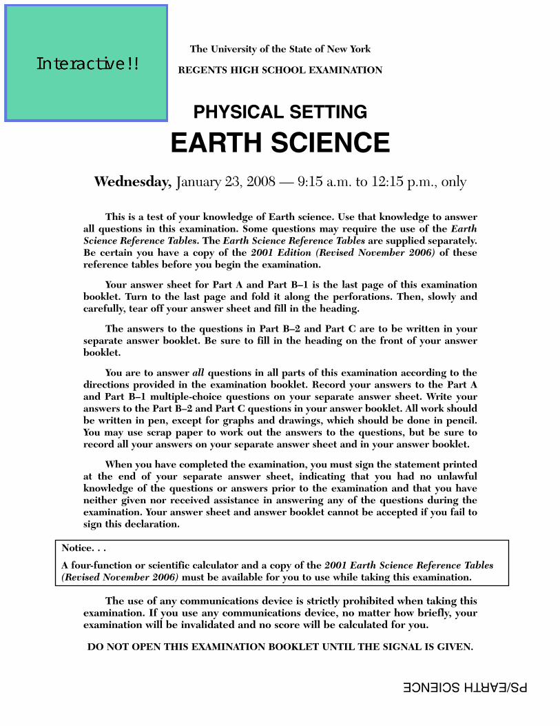
32 Which sequence of New York State index fossils shows the order in which the organisms appeared on Earth?
33 The generalized landscape regions of New York State are classified according to(1) bedrock structure and elevation (3) latitude and longitude(2) bedrock type and index fossils (4) climate and topography
Oldest Youngest
( 1 )
Time
Oldest Youngest
( 2 )
Time
Youngest
( 3 )
Time
Oldest Youngest
( 4 )
Time
Oldest

P.S./E. Sci.–Jan. ’08 [8]
34 Point X is a location on the topographic map below. Elevations are measured in meters.
What is a possible elevation, in meters, of point X?(1) 55 (3) 68(2) 57 (4) 70
35 The topographic map below shows two hills labeled A and B. The tributary streams labeled X and Y havethe same volume of water.
Which statement is best supported by the map?(1) Hill A is higher than hill B. (3) Stream X flows faster than stream Y.(2) Hill B is higher than hill A. (4) Stream Y flows faster than stream X.
Stream
A
B
N
X
Y
75
X
50N

Part B–1
Answer all questions in this part.
Directions (36–50): For each statement or question, write on your separate answer sheet the number of theword or expression that, of those given, best completes the statement or answers the question. Some questionsmay require the use of the Earth Science Reference Tables.
Base your answers to questions 36 and 37 on the map below, which represents an imaginary continent.Locations A and B are on opposite sides of a mountain range on a planet similar to Earth. Location C is on theplanet’s equator.
36 Compared to the climate at location A, the climate at location B would most likely be(1) warmer and more humid (3) cooler and more humid (2) warmer and less humid (4) cooler and less humid
37 Location C most likely experiences(1) low air pressure and low precipitation(2) low air pressure and high precipitation(3) high air pressure and low precipitation(4) high air pressure and high precipitation
P.S./E. Sci.–Jan. ’08 [9] [OVER]

P.S./E. Sci.–Jan. ’08 [10]
Base your answers to questions 38 through 40 on the flowchart below, which shows a general overview ofthe processes and substances involved in the weathering of rocks at Earth’s surface. Letter X represents animportant substance involved in both major types of weathering, labeled A and B on the flowchart. Someweathering processes are defined below the flowchart.
38 Which term best identifies the type of weathering represented by A?(1) physical (3) chemical(2) biological (4) glacial
39 Which substance is represented by X on both sides of the flowchart?(1) potassium feldspar (3) hydrochloric acid(2) air (4) water
40 Which weathering process is most common in a hot, dry environment?(1) abrasion (3) frost action(2) carbonation (4) hydrolysis
Exfoliation
Weathering
A B
CarbonationHydrolysis Frost action
ExpansionSubstanceX
Rock
Abrasion
Impacts withother minerals
Atmosphericgases
SubstanceX
Frost action – the breakup of rocks caused by the expansion of substance X
Abrasion – the wearing down of rocks or particles as they rub or bounce against other rocks
Exfoliation – the peeling away of large sheets of loosened material at the surface of a rock
Hydrolysis – the change in a material caused by contact with substance X
Carbonation – the change in a material caused by contact with carbonic acid
Definitions
one major type is one major type is
of
involves caused by
combines with
caused by
of
causing
causing causingcausing causing

Base your answers to questions 41 through 44 on the map below, which shows areas where certain minerals were mined in significant amounts during 1989.
41 In which New York State landscape region was most of the garnet mined?(1) Catskills (3) Tug Hill Plateau(2) Adirondack Mountains (4) Erie-Ontario Lowlands
42 What is a common use for the mineral that is mined at the southern end of the twolargest Finger Lakes?(1) making talcum powder (3) polishing jewelry(2) vulcanizing rubber (4) melting ice
43 The gypsum deposits in New York State were formed(1) as a result of volcanic eruptions (3) in a shallow ocean(2) as a result of metamorphism (4) in a glacial outwash plain
44 The mineral wollastonite has a hardness of 4.5 to 5. Which New York State mineralcould easily scratch wollastonite?(1) garnet (3) talc(2) halite (4) gypsum
ClS
S
SS
S
Cl
Cl
Cl
Wo
WoT
Cl
N
Key
Cl clay (shale)G gypsumGt garnet
S salt (halite)T talcWo wollastonite
limestone or dolostone
Mineral Resources of New York State
Gt
G
P.S./E. Sci.–Jan. ’08 [11] [OVER]

Base your answers to questions 45 and 46 on the cross section below, which shows an underwater mountain range in the Atlantic Ocean. The oceanic bedrock is composed mainly of basalt. Points X and Y arelocations in the bedrock that have been diverging at the same rate. The movement of the North American Plateand Eurasian Plate is shown by the two arrows.
45 Which statements best describe the age and magnetic orientation of the basalts foundat locations X and Y?(1) The basalt at location X is younger than the basalt at location Y. Both
locations have the same magnetic orientation.(2) The basalts at locations X and Y are the same age. Both locations have the
same magnetic orientation.(3) The basalts at locations X and Y are the same age. Location X has normal
magnetic orientation and location Y has reversed magnetic orientation.(4) The basalt at location X is older than the basalt at location Y. Location X has
reversed magnetic orientation and location Y has normal magnetic orientation.
( Not drawn to scale)
Atlantic Ocean
North American Plate Eurasian Plate
X Y
P.S./E. Sci.–Jan. ’08 [12]

46 Which cross section best represents the relative locations of Earth’s asthenosphere,rigid mantle, and stiffer mantle? (The cross sections are not drawn to scale.)
( 3 )( 1 )
Atlantic Ocean
North American Plate Eurasian Plate
X Y
Rigid mantle
Asthenosphere
Stiffer mantle
Atlantic Ocean
North American Plate Eurasian Plate
X Y
AsthenosphereRigid mantle
Stiffer mantle
( 4 )( 2 )
Atlantic Ocean
North American Plate Eurasian Plate
X Y
Stiffer mantle
Asthenosphere
Rigid mantle
Atlantic Ocean
North American Plate Eurasian Plate
X Y
Rigid mantle
Stiffer mantle
Asthenosphere
P.S./E. Sci.–Jan. ’08 [13] [OVER]

P.S./E. Sci.–Jan. ’08 [14]
Base your answers to questions 47 through 50 on the diagram below, which represents the Sun’s apparentpaths and the solar noon positions for an observer at 42° N latitude on December 21, September 23, and June 21.
47 In which direction will sunrise occur on June 21?(1) north of due west (3) south of due west(2) north of due east (4) south of due east
48 How many hours occurred between sunrise and solar noon on September 23?(1) 6 (3) 12(2) 8 (4) 24
49 Which diagram best shows the location of Polaris relative to the observer?
W
E
S NPolaris
( 1 )
W
E
S N
Polaris
( 2 )
W
E
S N
Polaris
( 3 )
W
E
S N
Polaris
( 4 )
Observer
Observer
Observer
Observer
June 21
W
E
Sun’sapparent
path
September 23
December 21
S N
Solar noon
Solar noon
Solar noon
Observer
( 1 ) ( 3 )
( 2 ) ( 4 )

P.S./E. Sci.–Jan. ’08 [15] [OVER]
50 Which graph best shows the altitude of the Sun, as measured by the observer locatedat 42° N, at various times on December 21?
Alt
itu
de
of
Su
n (
°)
Time on December 21
12 a.m. 6 a.m. noon midnight6 p.m.
90
45
0
( 1 )
Alt
itu
de
of
Su
n (
°)
90
45
0
( 2 )
Alt
itu
de
of
Su
n (
°)
90
45
0
( 3 )
Alt
itu
de
of
Su
n (
°)
90
45
0
( 4 )
Time on December 21
12 a.m. 6 a.m. noon midnight6 p.m.
Time on December 21
12 a.m. 6 a.m. noon midnight6 p.m.
Time on December 21
12 a.m. 6 a.m. noon midnight6 p.m.

Part B–2
Answer all questions in this part.
Directions (51–65): Record your answers in the spaces provided in your answer booklet. Some questionsmay require the use of the Earth Science Reference Tables.
Base your answers to questions 51 through 53 on the block diagram below, which shows the landscape features of an area of Earth’s crust. Two sedimentary rock layers, A and B, are labeled in the diagram. The rocksymbol for layer B has been omitted.
51 Identify the most abundant mineral in rock layer A. [1]
52 Describe how the caverns formed in rock layer A. [1]
53 The graph below shows the particle sizes that compose the clastic sedimentary rockin layer B.
In the box in your answer booklet, draw the map symbol from the Earth ScienceReference Tables that represents rock layer B. [1]
Co
mp
osi
tio
n (
%)
Particle Diameter (cm)0.100.080.060.040.020
Cavern
Layer A
Layer B
P.S./E. Sci.–Jan. ’08 [16]

Base your answers to questions 54 through 56 on the table below, which lists the location of some earthquakes, their Richter magnitude, and their year of occurrence.
Data Table
54 What data do scientists use to determine the magnitude of earthquakes without visiting the actual sites? [1]
55 The locations of the earthquakes listed in the table are shown on the map below.
Explain how the locations of these earthquakes are related to tectonic plates. [1]
56 Identify the process in Earth’s asthenosphere that is inferred to be the cause of tectonic plate motion. [1]
0° 40° 80° 160°120°40°80°120°160°0°
20°
40°
60°
80°
0°
20°
40°
60°
80°
20°
40°
60°
80°
20°
40°
60°
80°
San FranciscoMessina
Tokyo
Location Richter Magnitude Year
San Francisco, United States 7.8 1906
Messina, Italy 7.5 1908
Tokyo, Japan 8.3 1923
San Francisco, United States 7.1 1989
P.S./E. Sci.–Jan. ’08 [17] [OVER]

Base your answers to questions 57 through 60 on the diagram below, which shows Earth as viewed fromabove the North Pole. The nighttime side of Earth has been shaded. The Moon is shown at eight positions inits orbit around Earth. The name of each Moon phase is indicated at each Moon position. The dark portion ofeach Moon position has not been shaded.
57 On the diagram in your answer booklet, shade the portion of the Moon that is in darkness to show the last quarter phase as viewed from New York State. [1]
58 Explain what causes the Moon’s phases when viewed from Earth. [1]
59 Which Moon phase occurs approximately one week after the New Moon phase? [1]
60 Explain why the same side of the Moon always faces Earth. [1]
61 Complete the table in your answer booklet by identifying the color and classification of the star Procyon B. The data for the Sun have been completed as an example. [1]
(Not drawn to scale)
Lastquarter
Oldgibbous
FullMoon
Newgibbous
Firstquarter
Newcrescent
NewMoon
Oldcrescent
NorthPole
Sun’srays
P.S./E. Sci.–Jan. ’08 [18]

P.S./E. Sci.–Jan. ’08 [19] [OVER]
Base your answers to questions 62 through 65 on the cross section in your answer booklet which shows a portion of Earth’s crust. Letters A through J represent rock units or geologic structures. The rock units havenot been overturned.
62 On the cross section in your answer booklet, draw a circle around the letter of the oldest rock unit shown. [1]
63 On the same cross section, place an X to indicate a location where the rock, marble,was formed. [1]
64 Describe one piece of evidence shown in the cross section that suggests rock unit Dis younger than rock unit F. [1]
65 Explain why rock unit H is not one continuous layer. [1]

P.S./E. Sci.–Jan. ’08 [20]
Part C
Answer all questions in this part.
Directions (66–84): Record your answers in the spaces provided in your answer booklet. Some questionsmay require the use of the Earth Science Reference Tables.
Base your answers to questions 66 through 70 on the weather map in your answer booklet. The isobars showair pressures, in millibars. Points A and B indicate locations on the map.
66 On the weather map in your answer booklet, place an X centered on the geographicregion that was most likely the source of the mT air mass. [1]
67 Calculate the pressure gradient along a straight line between point A and point B onthe map. Label your answer with the correct units. [2]
68 Describe the evidence shown on the map that indicates strong winds were blowingbetween Miles City and Pierre. [1]
69 In the table in your answer booklet, write the names of the cities listed below insequence from lowest relative humidity to highest relative humidity. [1]
AlbuquerqueChicagoNew York City
70 Describe the pattern of the surface winds around the center of the low-pressure system (L). [1]
P.S./E. Sci.–Jan. ’08 [21] [OVER]
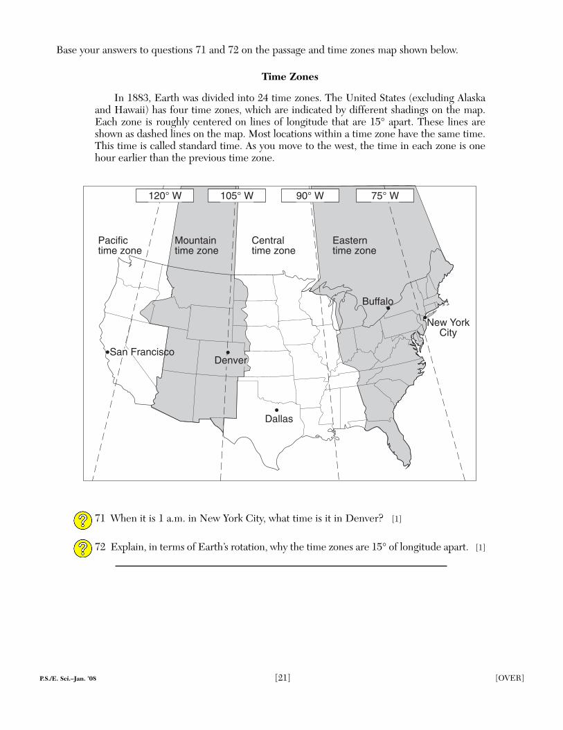
Base your answers to questions 71 and 72 on the passage and time zones map shown below.
Time Zones
In 1883, Earth was divided into 24 time zones. The United States (excluding Alaskaand Hawaii) has four time zones, which are indicated by different shadings on the map.Each zone is roughly centered on lines of longitude that are 15° apart. These lines areshown as dashed lines on the map. Most locations within a time zone have the same time.This time is called standard time. As you move to the west, the time in each zone is onehour earlier than the previous time zone.
71 When it is 1 a.m. in New York City, what time is it in Denver? [1]
72 Explain, in terms of Earth’s rotation, why the time zones are 15° of longitude apart. [1]
Dallas
Denver
Pacifictime zone
Centraltime zone
Easterntime zone
Mountaintime zone
Buffalo
New YorkCity
120° W 105° W 90° W 75° W
San Francisco

P.S./E. Sci.–Jan. ’08 [22]P.S./E. Sci.–Jan. ’08 [22]
Base your answers to questions 73 and 74 on the data table below, which shows the average number of days with thunderstorms that occur over land areas at different latitudes each year.
Data Table
73 On the grid in your answer booklet, plot, with an X, the average number of days peryear a thunderstorm occurs over a land area for each latitude shown on the data table.Connect the centers of the Xs with a line. [1]
74 State the relationship between latitude and the average number of days each year thatthunderstorms occur over a land area. [1]
LatitudeAverage Number of
Days a Thunderstorm Occurs Over Land
60° N 5
45° N 14
30° N 19
15° N 30
0° (equator) 56
15° S 44
30° S 21
45° S 8
60° S 0

P.S./E. Sci.–Jan. ’08 [23] [OVER]
Base your answers to questions 75 through 79 on the cross section below, which shows the general patternof water movement in the water cycle. Letter X represents a water-cycle process.
75 What process of the water cycle is represented by X? [1]
76 Describe the process of condensation. [1]
77 Describe one surface condition that would allow runoff to occur. [1]
78 Explain one role of plants in the water cycle. [1]
79 As the lake surface freezes in the winter, how many calories of heat are released byeach gram of water? [1]
Condensation andcloud formation
Winds carryvapor over land
Lake
Ocean
X
Impermeable bedrock
Water table
P.S./E. Sci.–Jan. ’08 [24]
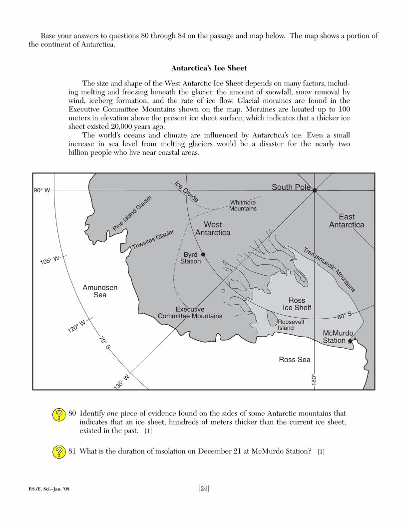
Base your answers to questions 80 through 84 on the passage and map below. The map shows a portion ofthe continent of Antarctica.
Antarctica’s Ice Sheet
The size and shape of the West Antarctic Ice Sheet depends on many factors, includ-ing melting and freezing beneath the glacier, the amount of snowfall, snow removal bywind, iceberg formation, and the rate of ice flow. Glacial moraines are found in theExecutive Committee Mountains shown on the map. Moraines are located up to 100meters in elevation above the present ice sheet surface, which indicates that a thicker icesheet existed 20,000 years ago.
The world’s oceans and climate are influenced by Antarctica’s ice. Even a smallincrease in sea level from melting glaciers would be a disaster for the nearly two billion people who live near coastal areas.
80 Identify one piece of evidence found on the sides of some Antarctic mountains thatindicates that an ice sheet, hundreds of meters thicker than the current ice sheet,existed in the past. [1]
81 What is the duration of insolation on December 21 at McMurdo Station? [1]
South Pole
105° W
120° W
135°
W
AmundsenSea
Ross Sea
ExecutiveCommittee Mountains
ByrdStation
WestAntarctica
WhitmoreMountains
Pine Is
land G
lacier
Thwaites Glacier
70° S
90° W
RossIce Shelf
RooseveltIsland
McMurdoStation
Ice Divide
80° S
EastAntarctica
180°
Transantarctic Mountains

82 State the latitude and longitude of Byrd Station. Your answer must include both theunits and the compass directions. [1]
83 Describe the arrangement of sediment found in a glacial moraine. [1]
84 Identify one change that would cause a decrease in the size of the West Antarctic Ice Sheet. [1]
P.S./E. Sci.–Jan. ’08 [25]

Performance Test Score(Maximum Score: 23)
Maximum Student’sPart Score Score
A 35
B–1 15
B–2 15
C 20
Total Written Test Score(Maximum Raw Score: 85)
Final Score(from conversion chart)
Raters’ Initials:
Rater 1 . . . . . . . . . . Rater 2 . . . . . . . . . .
The University of the State of New York
REGENTS HIGH SCHOOL EXAMINATION
PHYSICAL SETTINGEARTH SCIENCE
Wednesday, January 23, 2008 — 9:15 a.m. to 12:15 p.m., only
ANSWER BOOKLET
Student . . . . . . . . . . . . . . . . . . . . . . . . . . . . . . . . . . . . . . Sex: � Female
Teacher . . . . . . . . . . . . . . . . . . . . . . . . . . . . . . . . . . . . . . . . . . . . . . . . . . . . . .
School . . . . . . . . . . . . . . . . . . . . . . . . . . . . . . . . . . . . . . . Grade . . . . . . . . .
Answer all questions in Part B–2 and Part C. Record your answersin this booklet.
� Male
51
52
53
54
55
56
Part B–2
51
52
For Raters Only
53
54
55
56

PHYSICAL SETTING/EARTH SCIENCE – continued
[4]
Part B–2
Allow a total of 15 credits for this part. The student must answer all questions in this part.
51 [1] Allow 1 credit. Acceptable responses include, but are not limited to:
— calcite
— CaCO3
52 [1] Allow 1 credit. Acceptable responses include, but are not limited to:
— Limestone reacts with acids in groundwater.
— Acids in water cause limestone to dissolve.
— chemical weathering of limestone
— Water flowing through cracks removes limestone.
53 [1] Allow 1 credit for .
54 [1] Allow 1 credit. Acceptable responses include, but are not limited to:
— seismic wave recordings
— P-waves and S-waves
— seismograms
— damage reports
55 [1] Allow 1 credit. Acceptable responses include, but are not limited to:
— They are all located at or near tectonic plate boundaries.
— They are located where crustal plates meet.
56 [1] Allow 1 credit. Acceptable responses include, but are not limited to:
— convection currents
— convection
— density currents

For Raters Only
57
58
59
60
61
58
61
57
59
60
Star Color Classification
Sun yellow main sequence
Procyon B
[2]

57 [1] Allow 1 credit if approximately ½ of the Moon is shaded on the right-hand side.
Examples of 1-credit responses:
58 [1] Allow 1 credit. Acceptable responses include, but are not limited to:
— Moon phases are caused by the Moon revolving around Earth.
— The Moon traveling around Earth causes the Moon to show a cycle of phases.
— Different amounts of the lighted half of the Moon are seen from Earth.
59 [1] Allow 1 credit for first quarter.
60 [1] Allow 1 credit. Acceptable responses include, but are not limited to:
— The Moon’s rate of rotation equals the Moon’s rate of revolution.
— The Moon completes one spin on its axis in the same amount of time it takes to complete one orbit around Earth.
PHYSICAL SETTING/EARTH SCIENCE – continued
[5] [OVER]

For Raters Only
57
58
59
60
61
58
61
57
59
60
Star Color Classification
Sun yellow main sequence
Procyon B
[2]

61 [1] Allow 1 credit if both the color and classification are correct.
Example of a 1-credit response:
Star Color Classification
Procyon B yellow or yellow white white dwarf
[6]
PHYSICAL SETTING/EARTH SCIENCE – continued

[3] [OVER]
For Raters Only
62 and 63
64
65
62
64
Total Score for Part B–2
Igneousrock
Contactmetamorphism
Key
G
E
H
J I
D C
A
F
B
H63
65

PHYSICAL SETTING/EARTH SCIENCE – continued
62 [1] Allow 1 credit for circling letter I.
63 [1] Allow 1 credit if the center of the X is located anywhere in the contact metamorphic zone in the limestone layer.
Example of a correct response for questions 62 and 63:
64 [1] Allow 1 credit. Acceptable responses include, but are not limited to:
— There is no contact metamorphism shown in rock unit D.
— Rock unit F was eroded, then rock unit D was formed.
— There is a buried erosional surface between F and D.
— Rock unit D is on top of rock unit F.
65 [1] Allow 1 credit. Acceptable responses include, but are not limited to:
— Rock unit H was displaced by movement along a fault.
— Rock unit H was broken when an earthquake occurred.
XG
E
H
J I
D C
A
F
B
H
Igneousrock
Contactmetamorphism
Key
[7] [OVER]

[4]
For Raters Only
Part C
66
67 Gradient = _______________________
68
0 500 1,000 km
PacificOcean
AtlanticOcean
Gulf of Mexico
mT
H
10161020
4523
A
5021
B
L
cP
New YorkCity
50
4154
54
557968
984
988Chicago
992996
10041000
Pierre
MilesCity
1012 1012
10161008
Albuquerque
57
57
3152
39
66
68
67

Part C
Allow a total of 20 credits for this part. The student must answer all questions in this part.
66 [1] Allow 1 credit if the center of the student’s X is located over the water in the diagonally lined area.
67 [2] Allow a maximum of 2 credits, allocated as follows:
• Allow 1 credit for any value from 0.016 to 0.018.
• Allow 1 credit for the correct units. Acceptable responses include, but are not limited to:
— millibars per kilometer
— mb/km
0 500 1,000 km
NPacificOcean
AtlanticOcean
Gulf of Mexico
mT
H
10161020
4523
A
5021
B
L
cP
New YorkCity
50
4154
54
557968
984
988Chicago
992996
10041000
Pierre
MilesCity
1012 1012
10161008
Albuquerque
57
57
39
3152
[8]
PHYSICAL SETTING/EARTH SCIENCE – continued

[5] [OVER]
69
70
71
72
73
74
For Raters Only
69
70
Lowest Relative Humidity
Highest Relative Humidity
71
72
73
74

68 [1] Allow 1 credit. Acceptable responses include, but are not limited to:
— The isobars are close together between Miles City and Pierre.
— There is a large pressure gradient between Miles City and Pierre.
— The feathers on the station models indicate strong winds in that area.
69 [1] Allow 1 credit.
70 [1] Allow 1 credit. Acceptable responses include, but are not limited to:
— inward
— counterclockwise
— counterclockwise and toward the center
71 [1] Allow 1 credit for 11 p.m. Do not allow credit for 11 or 11 a.m.
72 [1] Allow 1 credit. Acceptable responses include, but are not limited to:
— Earth rotates at a rate of 15°/hr.
— Earth’s period of rotation is 24 hours.
— Earth spins 360° in 24 hours.
Albuquerque New York City Chicago
Lowest Relative Humidity
Highest Relative Humidity
[9] [OVER]
PHYSICAL SETTING/EARTH SCIENCE – continued

[5] [OVER]
69
70
71
72
73
74
For Raters Only
69
70
Lowest Relative Humidity
Highest Relative Humidity
71
72
73
74
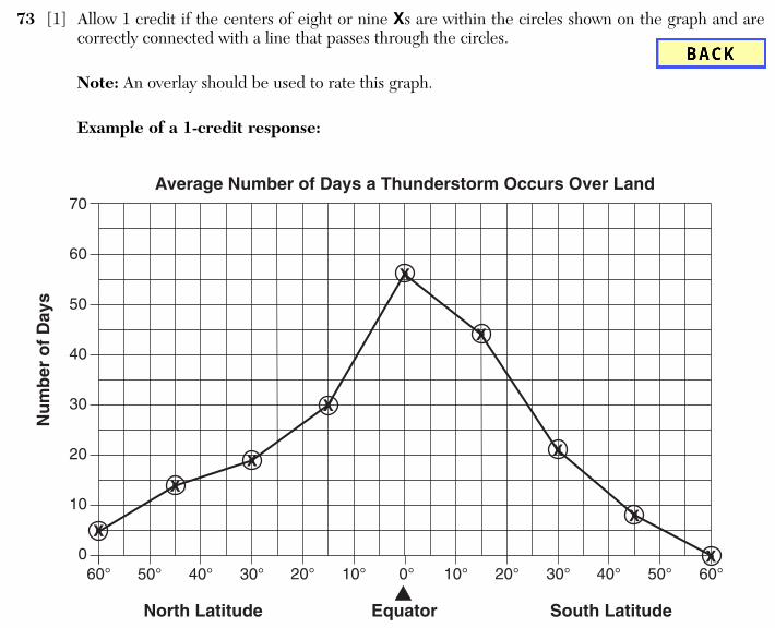
73 [1] Allow 1 credit if the centers of eight or nine Xs are within the circles shown on the graph and are correctly connected with a line that passes through the circles.
Note: An overlay should be used to rate this graph.
Example of a 1-credit response:
74 [1] Allow 1 credit. Acceptable responses include, but are not limited to:
— As latitude increases, the number of days with thunderstorms decreases.
— Lower latitudes have more thunderstorms.
— an inverse relationship between latitude and number of days with thunderstorms
70
60
50
40
30
20
10
0
Nu
mb
er o
f D
ays
Average Number of Days a Thunderstorm Occurs Over Land
60° 50° 40° 30° 20° 10° 0° 10° 20° 30° 40° 50° 60°
EquatorNorth Latitude South Latitude
X
X
X
X
X
X
X
X
X
PHYSICAL SETTING/EARTH SCIENCE – continued
[10]


![PHYSICAL SETTING CHEMISTRY - JMAP · PDF filePhysical Setting/Chemistry mustbeavailableforyoutousewhiletakingthisexamination. ... P.S./Chem.–Jan. ’16 [3] [OVER] 13 Partspermillionisusedtoexpressthe](https://img.pdfslide.net/doc/110x75/5aa0e8147f8b9a89178eb314/physical-setting-chemistry-jmap-settingchemistry-mustbeavailableforyoutousewhiletakingthisexamination.jpg)