Embed Size (px)
Citation preview

Pilbara Gold Project – Unlocking Shareholder Value
ASX Announcement 28 September 2017
ASX Code DEG
FRA Code WKN 633879
ABN 65 094 206 292
COMPANY DIRECTORS
Simon Lill
Executive Chairman
Davide Bosio
Non-executive Director
Steve Morris
Non-executive Director
Craig Nelmes
Company Secretary/CFO
CONTACT DETAILS
Principal & Registered Office
Level 2, Suite 9
389 Oxford Street
Mt Hawthorn WA 6016
PO Box 281
Mt Hawthorn WA 6016
www.degreymining.com.au
T +61 8 9381 4108
F +61 8 9381 6761
Pilbara Gold Project increases gold resources by >20% to over 1.2Moz
Highlights
Total Resource (↑20%) 23.88Mt @ 1.6g/t Au (1,210,000oz)
M & I (49%) (↑10%) 11.61Mt @ 1.6g/t Au (590,500oz)
Oxide (38%) (↑19%) 9.51Mt @ 1.5g/t Au (459,600oz)
Fresh (62%) (↑22%) 14.37Mt @ 1.6g/t Au (750,400oz)
New gold resources added:
Toweranna 0.43Mt @ 2.9g/t Au (40,700oz)
Mallina 3.74Mt @ 1.2g/t Au (147,100oz)
Leach Pad 0.86Mt @ 0.7g/t Au (19,300oz)
Increase in overall resource ounces of 207,000 oz.
Additional resources reduce acquisition value of Indee Gold project to $20/oz. with further significant exploration potential.
Toweranna and Mallina remain open with significant upside.
Leach Pad economics expected to be favourable - already mined, crushed and located next to the proposed plant site.
Potential to extend scoping study mine life and improve overall project economics.
Total Mineral Resources – Base Metals (unchanged)
3.47Mt @ 3.2% Zn, 1.3% Pb, 0.1% Cu, 0.8g/t Au, 110g/t Ag
(111,000t Zn, 46,100t Pb, 4,100t Cu, 91,900oz Au and 12.3Moz Ag)
Operations Manager, Andy Beckwith commented:
“The 20% increase in gold resources is a great outcome and demonstrates the potential still to be discovered in the region.
These resources will now be evaluated and added to our previous scoping study assessment, which noted that any increased mine life will make a significant positive financial impact.
Our priorities are to increase project resources through exploration, drilling and acquisition. Priority is for open pit resources within 50km of proposed mine site.
De Grey’s new Conglomerate Gold target provides an added dimension to exploration and any new high-grade resource, large or small, can have a tremendous impact to our development plans.”
For
per
sona
l use
onl
y
Page | 2
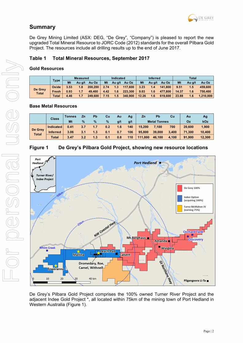
Summary
De Grey Mining Limited (ASX: DEG, “De Grey”, “Company”) is pleased to report the new upgraded Total Mineral Resource to JORC Code (2012) standards for the overall Pilbara Gold Project. The resources include all drilling results up to the end of June 2017.
Table 1 Total Mineral Resources, September 2017
Gold Resources
Base Metal Resources
Figure 1 De Grey’s Pilbara Gold Project, showing new resource locations
De Grey’s Pilbara Gold Project comprises the 100% owned Turner River Project and the adjacent Indee Gold Project *, all located within 75km of the mining town of Port Hedland in Western Australia (Figure 1).
Mt Au g/t Au Oz Mt Au g/t Au Oz Mt Au g/t Au Oz Mt Au g/t Au Oz
Oxide 3.53 1.8 200,200 2.74 1.3 117,600 3.23 1.4 141,800 9.51 1.5 459,600
Fresh 0.93 1.7 49,400 4.42 1.6 223,300 9.03 1.6 477,800 14.37 1.6 750,400
Total 4.46 1.7 249,600 7.15 1.5 340,900 12.26 1.6 619,600 23.88 1.6 1,210,000
Total
De Grey Total
TypeMeasured Indicated Inferred
Tonnes Zn Pb Cu Au Ag Zn Pb Cu Au Ag
Mt % % % g/t g/t Oz kOz
Indicated 0.41 3.7 1.7 0.2 1.6 140 15,200 7,100 700 20,600 1,900
Inferred 3.06 3.1 1.3 0.1 0.7 106 95,800 39,000 3,400 71,300 10,400
Total 3.47 3.2 1.3 0.1 0.8 110 111,000 46,100 4,100 91,900 12,300
De Grey
Total
ClassMetal Tonnes
For
per
sona
l use
onl
y
Page | 3
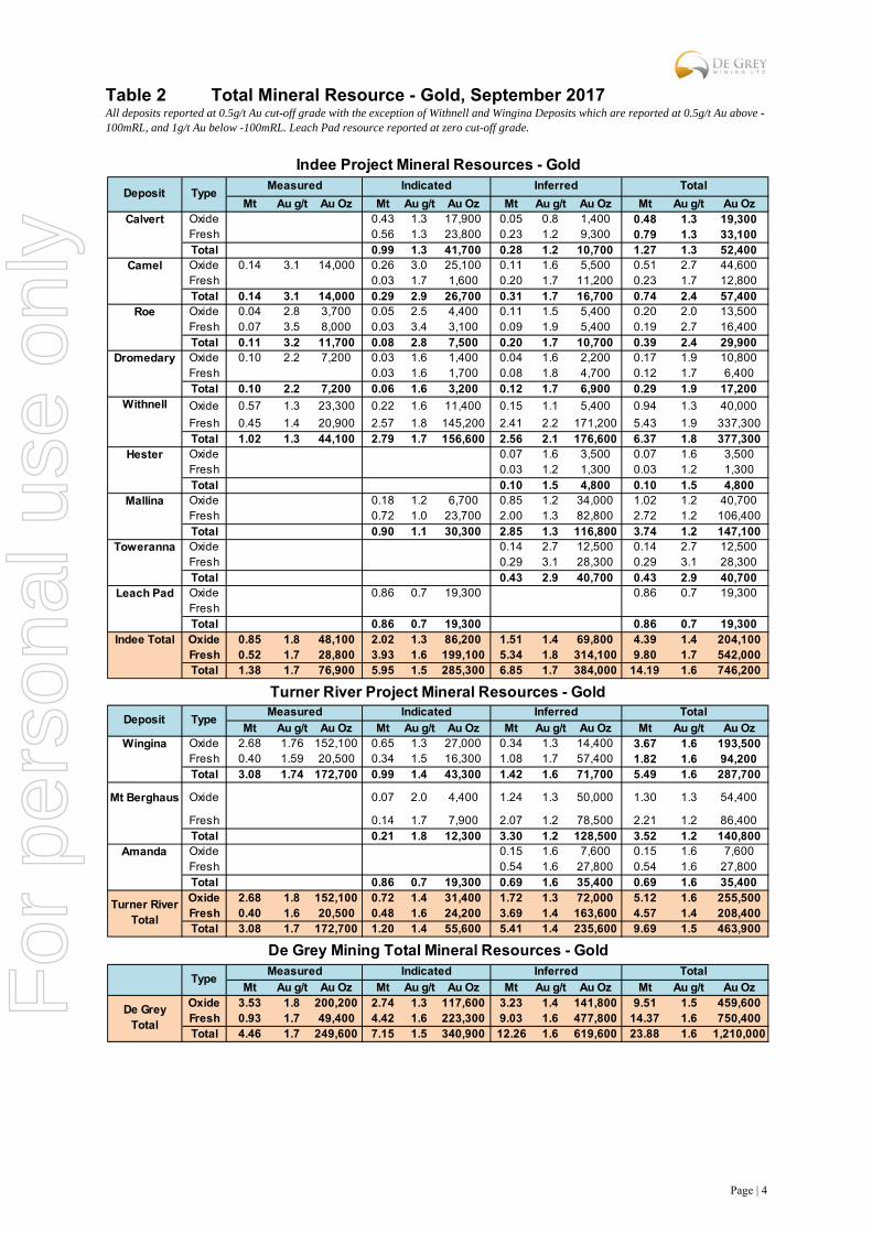
*De Grey has secured an option to acquire 100% of the Indee Gold Project and is required to elect to proceed with the acquisition in January 2018 with the remaining payment of $14.9M to be finalised in July 2018. (refer to ASX release dated 09 Feb 2017, “Acquisition of Indee Gold provides Scale and Development Momentum”).
The resources listed in the summary tables above includes the Indee Gold Project resources assuming the project is developed as one project and final acquisition of 100% of the Indee Gold Project is completed. The full breakdown of the resources by project and deposit are provided in Table 2.
The Company is currently evaluating potential economics of open pit mining from the various combined deposits and processing through a centralised and purpose built CIL processing plant. De Grey recently completed an initial high-level scoping study which showed a positive cashflow scenario with a 5-year open pit mine life at a processing rate of 1Mt per year. The new additional resources reported in this report remain to be included in the scoping study evaluation.
The combined Pilbara Gold Project total resources have grown substantially over the previous 12 months. The previous JORC Code (2012) resource estimates on the Turner River Projects and Indee Gold Project were previously reported in ASX releases as listed below:
Turner River - Gold Resources 25 January 2017 “Mt Berghaus Gold Resource Trebles - Increases by 98,000oz to 141,000oz
Indee - Gold Resources 3 April 2017 “1.0M ounce milestone achieved with Indee Resource Update – increased grade, tonnes”
Turner River – Base Metal Resources 8 November 2016 “Substantial resource increase for the Turner River VMS (Zn-Pb-Au-Ag) deposits”
All resources have been completed by Payne Geological Services Pty Ltd, an external and independent mining consultancy. The new additional resources updated in this report includes the results of recent RC drilling completed by De Grey Mining up to June 2017 and since signing the Option Agreement in February 2017.
The new resources at Mallina and the Heap Leach Pad have been completed based on drilling undertaken by De Grey, complimenting previous drilling completed by the vendors prior to 2017. The resources completed at Toweranna are based on drilling by previous owners of the project. The new resources at Mallina, Leach Pad and Toweranna are additional resources and have been added to the previously reported 2012 JORC resources, which remain unchanged since previous reporting.
All resources remain open in most directions and particularly at depth, except the Leach Pad resource which comprises the previously mined, crushed (<25mm) and stacked material remaining on the historic leach pad used during the earlier mining and processing period from 2006 to 2008.
For
per
sona
l use
onl
y
Page | 4
Table 2 Total Mineral Resource - Gold, September 2017 All deposits reported at 0.5g/t Au cut-off grade with the exception of Withnell and Wingina Deposits which are reported at 0.5g/t Au above -100mRL, and 1g/t Au below -100mRL. Leach Pad resource reported at zero cut-off grade.
Mt Au g/t Au Oz Mt Au g/t Au Oz Mt Au g/t Au Oz Mt Au g/t Au OzCalvert Oxide 0.43 1.3 17,900 0.05 0.8 1,400 0.48 1.3 19,300
Fresh 0.56 1.3 23,800 0.23 1.2 9,300 0.79 1.3 33,100Total 0.99 1.3 41,700 0.28 1.2 10,700 1.27 1.3 52,400
Camel Oxide 0.14 3.1 14,000 0.26 3.0 25,100 0.11 1.6 5,500 0.51 2.7 44,600Fresh 0.03 1.7 1,600 0.20 1.7 11,200 0.23 1.7 12,800Total 0.14 3.1 14,000 0.29 2.9 26,700 0.31 1.7 16,700 0.74 2.4 57,400
Roe Oxide 0.04 2.8 3,700 0.05 2.5 4,400 0.11 1.5 5,400 0.20 2.0 13,500Fresh 0.07 3.5 8,000 0.03 3.4 3,100 0.09 1.9 5,400 0.19 2.7 16,400Total 0.11 3.2 11,700 0.08 2.8 7,500 0.20 1.7 10,700 0.39 2.4 29,900
Dromedary Oxide 0.10 2.2 7,200 0.03 1.6 1,400 0.04 1.6 2,200 0.17 1.9 10,800Fresh 0.03 1.6 1,700 0.08 1.8 4,700 0.12 1.7 6,400Total 0.10 2.2 7,200 0.06 1.6 3,200 0.12 1.7 6,900 0.29 1.9 17,200
Oxide 0.57 1.3 23,300 0.22 1.6 11,400 0.15 1.1 5,400 0.94 1.3 40,000
Fresh 0.45 1.4 20,900 2.57 1.8 145,200 2.41 2.2 171,200 5.43 1.9 337,300Total 1.02 1.3 44,100 2.79 1.7 156,600 2.56 2.1 176,600 6.37 1.8 377,300
Hester Oxide 0.07 1.6 3,500 0.07 1.6 3,500Fresh 0.03 1.2 1,300 0.03 1.2 1,300Total 0.10 1.5 4,800 0.10 1.5 4,800
Mallina Oxide 0.18 1.2 6,700 0.85 1.2 34,000 1.02 1.2 40,700Fresh 0.72 1.0 23,700 2.00 1.3 82,800 2.72 1.2 106,400Total 0.90 1.1 30,300 2.85 1.3 116,800 3.74 1.2 147,100
Toweranna Oxide 0.14 2.7 12,500 0.14 2.7 12,500Fresh 0.29 3.1 28,300 0.29 3.1 28,300Total 0.43 2.9 40,700 0.43 2.9 40,700
Leach Pad Oxide 0.86 0.7 19,300 0.86 0.7 19,300FreshTotal 0.86 0.7 19,300 0.86 0.7 19,300
Indee Total Oxide 0.85 1.8 48,100 2.02 1.3 86,200 1.51 1.4 69,800 4.39 1.4 204,100Fresh 0.52 1.7 28,800 3.93 1.6 199,100 5.34 1.8 314,100 9.80 1.7 542,000Total 1.38 1.7 76,900 5.95 1.5 285,300 6.85 1.7 384,000 14.19 1.6 746,200
Mt Au g/t Au Oz Mt Au g/t Au Oz Mt Au g/t Au Oz Mt Au g/t Au OzWingina Oxide 2.68 1.76 152,100 0.65 1.3 27,000 0.34 1.3 14,400 3.67 1.6 193,500
Fresh 0.40 1.59 20,500 0.34 1.5 16,300 1.08 1.7 57,400 1.82 1.6 94,200Total 3.08 1.74 172,700 0.99 1.4 43,300 1.42 1.6 71,700 5.49 1.6 287,700
Mt Berghaus Oxide 0.07 2.0 4,400 1.24 1.3 50,000 1.30 1.3 54,400
Fresh 0.14 1.7 7,900 2.07 1.2 78,500 2.21 1.2 86,400Total 0.21 1.8 12,300 3.30 1.2 128,500 3.52 1.2 140,800
Amanda Oxide 0.15 1.6 7,600 0.15 1.6 7,600Fresh 0.54 1.6 27,800 0.54 1.6 27,800Total 0.86 0.7 19,300 0.69 1.6 35,400 0.69 1.6 35,400Oxide 2.68 1.8 152,100 0.72 1.4 31,400 1.72 1.3 72,000 5.12 1.6 255,500Fresh 0.40 1.6 20,500 0.48 1.6 24,200 3.69 1.4 163,600 4.57 1.4 208,400Total 3.08 1.7 172,700 1.20 1.4 55,600 5.41 1.4 235,600 9.69 1.5 463,900
Mt Au g/t Au Oz Mt Au g/t Au Oz Mt Au g/t Au Oz Mt Au g/t Au OzOxide 3.53 1.8 200,200 2.74 1.3 117,600 3.23 1.4 141,800 9.51 1.5 459,600Fresh 0.93 1.7 49,400 4.42 1.6 223,300 9.03 1.6 477,800 14.37 1.6 750,400Total 4.46 1.7 249,600 7.15 1.5 340,900 12.26 1.6 619,600 23.88 1.6 1,210,000
Total
Turner River Total
De Grey Total
De Grey Mining Total Mineral Resources - Gold
TypeMeasured Indicated Inferred
Indee Project Mineral Resources - Gold
Turner River Project Mineral Resources - Gold
Deposit TypeMeasured Indicated Inferred Total
DepositTotal Measured Indicated Inferred
Type
Withnell
For
per
sona
l use
onl
y
Page | 5
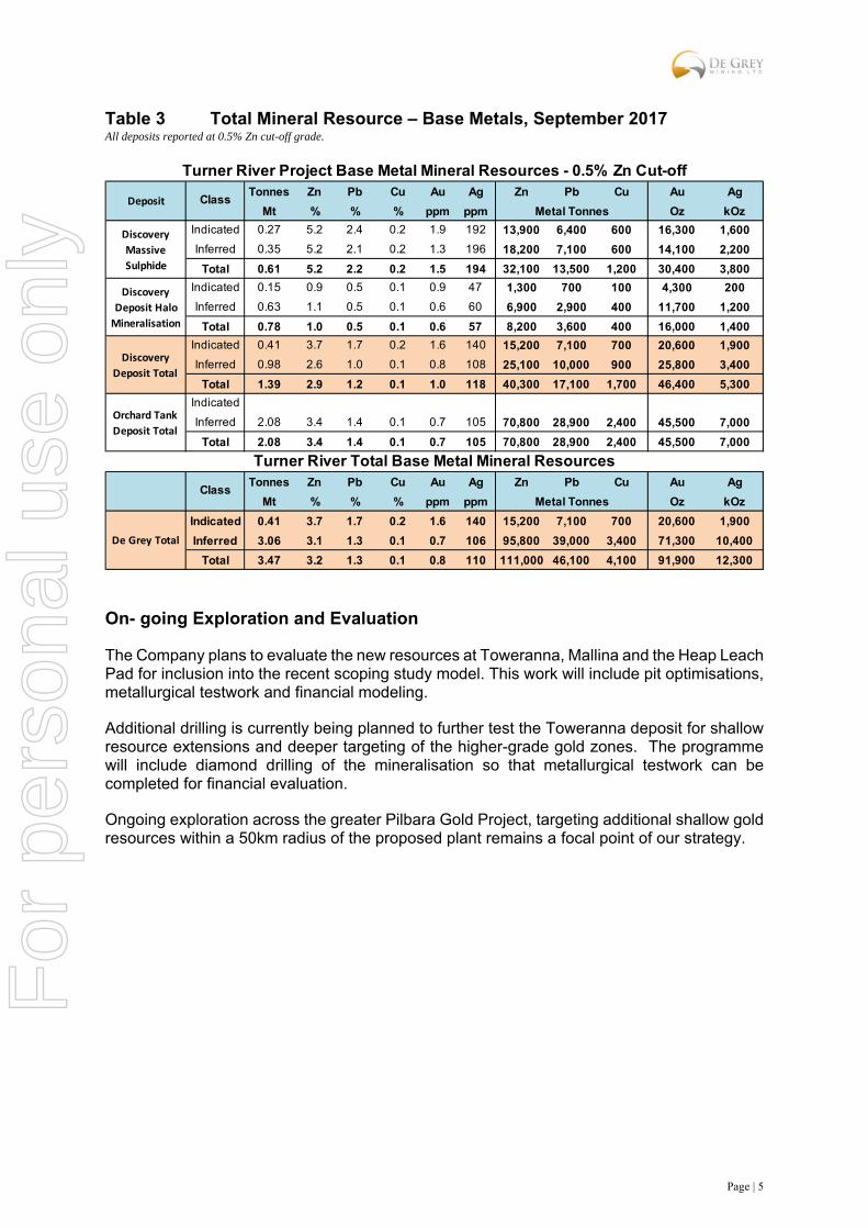
Table 3 Total Mineral Resource – Base Metals, September 2017 All deposits reported at 0.5% Zn cut-off grade.
On- going Exploration and Evaluation
The Company plans to evaluate the new resources at Toweranna, Mallina and the Heap Leach Pad for inclusion into the recent scoping study model. This work will include pit optimisations, metallurgical testwork and financial modeling.
Additional drilling is currently being planned to further test the Toweranna deposit for shallow resource extensions and deeper targeting of the higher-grade gold zones. The programme will include diamond drilling of the mineralisation so that metallurgical testwork can be completed for financial evaluation.
Ongoing exploration across the greater Pilbara Gold Project, targeting additional shallow gold resources within a 50km radius of the proposed plant remains a focal point of our strategy.
Tonnes Zn Pb Cu Au Ag Zn Pb Cu Au Ag
Mt % % % ppm ppm Oz kOz
Indicated 0.27 5.2 2.4 0.2 1.9 192 13,900 6,400 600 16,300 1,600
Inferred 0.35 5.2 2.1 0.2 1.3 196 18,200 7,100 600 14,100 2,200
Total 0.61 5.2 2.2 0.2 1.5 194 32,100 13,500 1,200 30,400 3,800
Indicated 0.15 0.9 0.5 0.1 0.9 47 1,300 700 100 4,300 200
Inferred 0.63 1.1 0.5 0.1 0.6 60 6,900 2,900 400 11,700 1,200
Total 0.78 1.0 0.5 0.1 0.6 57 8,200 3,600 400 16,000 1,400
Indicated 0.41 3.7 1.7 0.2 1.6 140 15,200 7,100 700 20,600 1,900
Inferred 0.98 2.6 1.0 0.1 0.8 108 25,100 10,000 900 25,800 3,400
Total 1.39 2.9 1.2 0.1 1.0 118 40,300 17,100 1,700 46,400 5,300
Indicated
Inferred 2.08 3.4 1.4 0.1 0.7 105 70,800 28,900 2,400 45,500 7,000
Total 2.08 3.4 1.4 0.1 0.7 105 70,800 28,900 2,400 45,500 7,000
Tonnes Zn Pb Cu Au Ag Zn Pb Cu Au Ag
Mt % % % ppm ppm Oz kOz
Indicated 0.41 3.7 1.7 0.2 1.6 140 15,200 7,100 700 20,600 1,900
Inferred 3.06 3.1 1.3 0.1 0.7 106 95,800 39,000 3,400 71,300 10,400
Total 3.47 3.2 1.3 0.1 0.8 110 111,000 46,100 4,100 91,900 12,300
De Grey Total
Deposit
Turner River Total Base Metal Mineral Resources
Turner River Project Base Metal Mineral Resources - 0.5% Zn Cut-off
Discovery
Massive
Sulphide
Discovery
Deposit Halo
Mineralisation
Discovery
Deposit Total
Orchard Tank
Deposit Total
ClassMetal Tonnes
ClassMetal Tonnes
For
per
sona
l use
onl
y

Page | 6
1. New Resource Summary – Mallina Gold Deposit
Geology
At Mallina, gold mineralisation and associated alteration zones occur as linear multiple stacked lodes hosted within metasediments. The gold is intimately associated with quartz veining, carbonate and sulphide alteration, in places along the margins of 2m-30m wide porphyry intrusions within the east-west trending, 200m-wide structural corridor.
The weathering profile comprises a veneer of calcrete or transported sands overlying weathered bedrock to a depth of up to 50m.
Drilling
A total of 185 reverse circulation (RC) holes, 12 diamond (DD) holes, and 17 RC holes with diamond tails define the Mineral Resource. The majority of holes in the resource were reverse circulation holes drilled by De Grey in 2017. RAB and air core (AC) drilling is included in the database but these holes were excluded from the estimate. Drilling at the deposit has occurred over multiple campaigns from 1968 to 2017. The majority of the Mallina deposit has been drilled at 20m hole spacing on 50m spaced N-S cross sections. Some areas in the western end of the deposit have been drilled at 100m spaced sections.
De Grey hole collars were surveyed by contract surveyors using DGPS. Historic drill hole collars were surveyed in AMG coordinates using RTK GPS and have since been transformed to MGA grid. Down hole surveys were recorded for the majority of holes at 50m intervals using a single shot Eastman camera or a Reflex multi-shot tool.
Sampling and Sub-Sampling Techniques
For De Grey RC drilling, a face-sampling hammer was used with samples collected at 1m intervals from mineralised zones with composite sampling of typically 4m in the unmineralised rocks. Samples were collected through a rig-mounted cone splitter. Samples were visually assessed for recovery and were kept dry throughout the mineralised zones.
The historical RC drilling was sampled at 1m intervals and split using a 87.5:12.5 conventional riffle splitter.
Diamond core was HQ3 size and sampled to geological intervals or on a 1 metre basis from half core cut with a diamond saw.
Sample Analysis Method
For all De Grey drilling, whole samples were crushed then pulverised and analysed for gold at a contract laboratory using a fire assay technique. QAQC protocols were in place for the drilling programs and has confirmed the quality of the sampling and assaying.
The majority of historic RC and diamond drilling was assayed at contract laboratories using a fire assay method. QAQC data has not been reviewed, but the tenor and geometry of mineralisation is consistent with the recent De Grey drilling.
Estimation Methodology
At the Mallina deposit, the resource was largely estimated using ordinary kriging (“OK”) grade interpolation of 1m composited data within wireframes prepared using nominal 0.4g/t Au envelope. Interpolation parameters were based on geostatistical analysis of the main lode and considered the geometry of individual lodes. A first pass search range of 60m was used with a minimum of 10 samples and a maximum of 30 samples. The majority of the resource (88%)
For
per
sona
l use
onl
y

Page | 7
was estimated in the first pass. Minor lodes with few samples were estimated using inverse distance interpolation.
A high grade cut of 10g/t was applied to the majority of lodes. A number of small lodes were estimated with a high grade cut of 5g/t.
The block dimensions used in the Mallina model was 20m EW by 5m NS by 5m vertical with sub-cells of 5m by 1.25m by 1.25m.
Limited bulk density data is available for the deposits from the drilling data, so values used at the main Indee deposits were applied. Bulk density values applied to the Mallina estimate was 2.3t/m3 for oxide and 2.6t/m3 for sulphide mineralisation.
Mineral Resource Classification
The two main central lodes at Mallina have been defined by a drill spacing of 50m sections and 20m hole spacing on each section. The areas showing good continuity of mineralisation along these lodes have been classified as Indicated Mineral Resource. The remaining lodes at Mallina have been defined by single sections of drilling, or show poor continuity along strike, and have been classified as Inferred Mineral Resource.
Deep drilling has been completed on a number of sections at Mallina. To reflect the potential for extraction by open pit methods, the Mineral Resource has only been reported to a depth of 100m vertical.
Cut-off Grades
The shallow, sub-cropping nature of the deposits suggests good potential for open pit mining. As such, the Mineral Resource has been reported at a 0.5g/t Au lower cut-off to reflect assumed exploitation by open pit mining.
Metallurgy
No metallurgical test work has been conducted on the mineralisation at Mallina. Work is planned, but it is assumed that metallurgical characteristics are similar to the main Indee deposits.
Modifying Factors
No modifying factors were applied to the reported Mineral Resource estimate. Parameters reflecting mining dilution, ore loss and metallurgical recoveries will be considered during the planned mining evaluation of the project.
For
per
sona
l use
onl
y
Page | 8
2. New Resource Summary – Toweranna Gold Deposit
Geology
At Toweranna, gold mineralisation occurs in numerous variously oriented pyrite-rich quartz veins which occur within, and marginal to, a granite stock. Lodes typically strike north-south, with a moderate easterly dip. The mineralisation and host rocks are weathered to a depth of up to 50m.
Drilling
A total of 37 RC holes and 18 diamond holes define the Mineral Resource. Drilling at the deposit has occurred over multiple campaigns from 1970 to 1995.
The Toweranna deposit has been drilled at 20m hole spacing on 20m spaced E-W cross sections along the western margin of the granite. The northern and eastern portions have drill hole spacings of 30m by 30m. RAB drilling is included in the database but these holes were excluded from the estimate.
Historic drill hole collars were surveyed in AMG coordinates using RTK GPS and have since been transformed to MGA grid. Only the deep diamond drill holes have down hole survey completed using a Tropari single shot instrument.
Sampling and Sub-sampling Techniques
Historical RC drill samples were collected at 1m intervals via a rig mounted multiple splitter. Samples were passed through a single stage Riffle splitter to form 2m composites for analysis. For a number of holes, 2m composites were collected using a 50mm plastic tube pushed into the large plastic bags. Diamond drill core was sampled at 1m intervals or smaller selected intervals based on observed mineralogy or quartz veining, with half core sent for analysis.
Sample Analysis Method
The earliest drill samples collected between 1970-1973 were analysed for gold by atomic absorption following aqua-regia digest of a 5g sample. Later samples were fire assayed using a 30g charge. For the more recent drill samples a 50g split was collected and fire assayed using aqua regia digest and reading by AAS method. QAQC protocols were not in place for the various drilling programs. A degree of confidence in the assay results can be gained from the repeatability of results between the different generations of drilling over the 25 year exploration history.
Estimation Methodology
The Toweranna resource was estimated using inverse distance squared (“ID2”) grade interpolation of 1m composited data within wireframes prepared using nominal 0.4g/t Au envelope. Interpolation parameters were based on the geometry of individual lodes. A first pass search range of 30m was used with a minimum of 6 samples and a maximum of 24 samples. The majority of the resource (72%) was estimated in the first pass.
A high grade cut of 15g/t was applied to the majority of lodes.
The block dimensions used in the Toweranna model was 5m EW by 10m NS by 5m vertical with sub-cells of 1.25m by 2.5m by 1.25m.
Assumed bulk density values were applied to the Toweranna estimate. These were 2.3t/m3 for oxide and 2.7t/m3 for sulphide mineralisation.
For
per
sona
l use
onl
y
Page | 9
Mineral Resource Classification
All data at Toweranna is historical with the most recent samples being analysed in 1995 without QAQC protocols. For this reason the entire deposit has been classified as Inferred Mineral Resource. Extensive historical workings within the resource area provide some confidence in the extent and continuity of mineralisation.
Further drilling is planned at Toweranna to both infill previously drilled areas to increase the resource classification and to test for extensions along strike and down dip.
Cut-off Grades
The shallow, sub-cropping nature of the deposits suggests good potential for open pit mining. As such, the Mineral Resource has been reported at a 0.5g/t Au lower cut-off to reflect assumed exploitation by open pit mining.
Metallurgy
Metallurgical test work completed by a previous operator in 1995 has demonstrated that the mineralisation at Toweranna is free milling. Bottle roll tests showed gold recoveries averaging 96% from oxide and primary mineralisation. Further test work is planned to confirm the earlier metallurgical results.
Modifying Factors
No modifying factors were applied to the reported Mineral Resource estimate. Parameters reflecting mining dilution, ore loss and metallurgical recoveries will be considered during the planned mining evaluation of the project.
3. New Resource Summary – Leach Pad Gold Deposit
Geology
The Leach Pad consists of material sourced from the Withnell and Camel pits. The gold mineralisation is hosted within oxidized metasediments with all material crushed to 25mm and stacked to a vertical height of up to 16m.
Drilling
The Leach Pad Mineral Resource is defined by 49 push-probe drill holes for a total of 366m and an average depth of 7.5m. All holes were completed by De Grey in 2017. Holes were drilled at 20m hole spacings on 40m to 50m spaced cross sections. The pad dimensions were 300m NS by 210m EW with a maximum height of 16m.
Sampling and Sub-sampling Techniques
The push-probe holes were sampled in entirety, with individual samples collected in acrylic tubes for each 1.5m rod length to generate samples of 2.5-4kg in weight.
Sample Analysis Method
For all De Grey drilling, whole samples were crushed then pulverised and analysed for gold at a contract laboratory using a fire assay technique. QAQC protocols were in place for the drilling programs and has confirmed the quality of the sampling and assaying.
For
per
sona
l use
onl
y
Page | 10
Estimation Methodology
At the Leach Pad deposit, the resource was estimated using ordinary kriging (“OK”) grade interpolation of 1.5m composited data. A high grade cut of 6g/t was applied to the 1.5m composites
The bounding surface and base of the pad was used to constrain the estimate. Interpolation parameters were based on geostatistical analysis of the data. A search range of 60m was used with a minimum of 10 samples and a maximum of 30 samples with a maximum of four samples per drill hole. All blocks were estimated in the first pass.
The block dimensions used in the Leach Pad model was 20m EW by 5m NS by 5m vertical with sub-cells of 5m by 1.25m by 1.25m.
No bulk density data was available for the deposit so an assumed value of 1.6t/m3 was used, based on information from similar stockpiles. The resulting tonnage matches very closely to the reported production of 851,000t.
Mineral Resource Classification
The entire leach pad was classified as Indicated Mineral Resource. The volume of the entire pad has been very accurately defined, and while mineralisation occurs throughout the full extent of the pad, a high degree of grade variability is evident in the data.
Cut-off Grades
Due to the expected homogenous nature of the material in the pad, no cut-off grade has been applied to the estimate.
COMPETENT PERSONS STATEMENTS The information in this report that relates to exploration results is based on, and fairly represents information and supporting documentation prepared by Mr. Philip Tornatora, a Competent Person who is a member of The Australasian Institute of Mining and Metallurgy. Mr. Tornatora is a consultant to De Grey Mining Limited. Mr. Tornatora has sufficient experience that is relevant to the style of mineralisation and type of deposit under consideration and to the activity being undertaken to qualify as a Competent Person as defined in the 2012 Edition of the “Australasian Code for Reporting of Exploration Results, Mineral Resource and Ore Reserves”. Mr. Tornatora consents to the inclusion in this report of the matters based on his information in the form and context in which it appears. The Information in this report that relates to Mineral Resources is based on information compiled by Mr Paul Payne, a Competent Person who is a Fellow of the Australasian Institute of Mining and Metallurgy. Mr Payne is a full-time employee of Payne Geological Services. Mr Payne has sufficient experience that is relevant to the style of mineralisation and type of deposit under consideration and to the activity being undertaken to qualify as a Competent Person as defined in the 2012 Edition of the “Australasian Code for Reporting of Exploration Results, Mineral Resources and Ore Reserves”. Mr Payne consents to the inclusion in the report of the matters based on his information in the form and context in which it appears. Mineral Resources for all Turner River gold and base metal deposits, and all Indee Gold Mineral Resources other than Mallina, Toweranna and Leach Pad have been previous reported under JORC 2012 reporting guidelines. The company confirms that it is not aware of any new information that materially affects the information included in the original market announcements and that all material assumptions and technical parameters underpinning the estimates continue to apply and have not materially changed. The company confirms that the form and context in which the Competent Person’s findings are presented have not been materially modified from the original market announcements. F
or p
erso
nal u
se o
nly

Page | 11
For further information: Simon Lill (Executive Chairman) or Andy Beckwith (Operations Manager) De Grey Mining Ltd Phone +61 8 9381 4108 [email protected]
For
per
sona
l use
onl
y
Page | 12
JORC Code, 2012 Edition: Mallina Gold Deposit
Section 1 Sampling Techniques and Data (Criteria in this section apply to all succeeding sections.)
Criteria JORC Code explanation Commentary
Sampling techniques
Nature and quality of sampling (e.g. cut channels, random chips, or specific specialised industry standard measurement tools appropriate to the minerals under investigation, such as down hole gamma sondes, or handheld XRF instruments, etc.). These examples should not be taken as limiting the broad meaning of sampling.
Include reference to measures taken to ensure sample representivity and the appropriate calibration of any measurement tools or systems used.
Aspects of the determination of mineralisation that are Material to the Public Report.
In cases where ‘industry standard’ work has been done this would be relatively simple (e.g. ‘reverse circulation drilling was used to obtain 1 m samples from which 3 kg was pulverised to produce a 30 g charge for fire assay’). In other cases, more explanation may be required, such as where there is coarse gold that has inherent sampling problems. Unusual commodities or mineralisation types (e.g. submarine nodules) may warrant disclosure of detailed information.
All DEG drilling and sampling was undertaken in an industry standard manner. Information is lacking for early historical drilling.
All DEG holes sampled on both a 1m and nominal 4m composite basis over the entire length of the hole. 4m composite samples were submitted for analysis for all intervals. Where assays over 0.2g/t Au were received for 4m composite sample results, 1m samples were then submitted for these zones.
Both the 4m and 1m samples were taken from a cone splitter mounted on the drill rig cyclone. The cyclone was calibrated to provide a continuous sample volume accordingly to sample length
Each 4m and 1m sample ranges from a typical 2.5-3.5kg
Air core (AC) drill holes completed by RED5 in 2003 were initially composite sampled at five metre intervals (2-3kg) by taking a scoop or spear sample from the one metre drill samples. The majority of the bulk 1m drill samples were retained at the drill site. Composite samples returning anomalous gold values were re-sampled at 1m intervals. The majority of resamples were split using a single stage riffle splitter, to produce a 2-3 kg sample that was submitted for assay.
Reverse circulation (RC) drill holes completed by RED5 were sampled at 1m intervals and split using a 87.5:12.5 conventional riffle splitter. The large split was retained in plastic bags at the drill site.
Drilling techniques
Drill type (e.g. core, reverse circulation, open-hole hammer, rotary air blast, auger, Bangka, sonic, etc.) and details (e.g. core diameter, triple or standard tube, depth of diamond tails, face-sampling bit or other type, whether core is oriented and if so, by what method, etc.).
All DEG drill holes are Reverse Circulation(RC) with a 5 1/2-inch bit and face sampling hammer.
Details are lacking for historical drilling of RAB, AC, RC, and diamond holes.
Drill sample recovery
Method of recording and assessing core and chip sample recoveries and results assessed.
Measures taken to maximise sample recovery and ensure representative nature of the samples.
Whether a relationship exists between sample recovery and grade and whether sample bias may have occurred due to preferential loss/gain of fine/coarse material.
All samples were visually assessed for recovery.
Samples are considered representative with good recoveries. Only a small percentage of samples were considered low recovery primarily due to change of rods when a small amount of wet sample occurred.
No sample bias is observed.
Logging Whether core and chip samples have been geologically and geotechnically logged to a level of
For DEG drilling, Consultant geologists logged each hole and supervised all sampling.
The sample results are appropriate for a
For
per
sona
l use
onl
y

Page | 13
Criteria JORC Code explanation Commentary
detail to support appropriate Mineral Resource estimation, mining studies and metallurgical studies.
Whether logging is qualitative or quantitative in nature. Core (or costean, channel, etc.) photography.
The total length and percentage of the relevant intersections logged.
resource estimation. The 1m sample results are considered the preferred sample to use in the resource estimation for more accurate definition of lodes.
Historical logging sheets by RED5 indicate that RC drill holes were logged for lithology.
The entire hole was logged.
Sub-sampling techniques and sample preparation
If core, whether cut or sawn and whether quarter, half or all core taken.
If non-core, whether riffled, tube sampled, rotary split, etc. and whether sampled wet or dry.
For all sample types, the nature, quality and appropriateness of the sample preparation technique.
Quality control procedures adopted for all sub-sampling stages to maximise representivity of samples.
Measures taken to ensure that the sampling is representative of the in situ material collected, including for instance results for field duplicate/second-half sampling.
Whether sample sizes are appropriate to the grain size of the material being sampled.
For DEG drilling, the sampling of the RC sample was carried out by a cone splitter on the rig cyclone and drill cuttings were sampled on a 1m and 4m composite basis.
Independent standard reference material was inserted approximately every 20 samples
Duplicate samples were taken approximately every 60 samples for 1m resplits
The samples are considered representative and appropriate for this type of drilling and for use in a future resource estimate.
QAQC procedures have not been documented for historical drilling.
Quality of assay data and laboratory tests
The nature, quality and appropriateness of the assaying and laboratory procedures used and whether the technique is considered partial or total.
For geophysical tools, spectrometers, handheld XRF instruments, etc., the parameters used in determining the analysis including instrument make and model, reading times, calibrations factors applied and their derivation, etc.
Nature of quality control procedures adopted (e.g. standards, blanks, duplicates, external laboratory checks) and whether acceptable levels of accuracy (i.e. lack of bias) and precision have been established.
The samples were submitted to a commercial independent laboratory in Perth, Australia.
Each sample was dried, crushed and pulverised.
Au was analysed by a 50gm charge Fire assay fusion technique with a AAS finish
The techniques are considered quantitative in nature.
As discussed previously standards and duplicates samples were inserted by the Company and the laboratory also carries out internal standards in individual batches
The standards and duplicates were considered satisfactory
Verification of sampling and assaying
The verification of significant intersections by either independent or alternative company personnel.
The use of twinned holes. Documentation of primary data,
data entry procedures, data verification, data storage (physical and electronic) protocols.
Discuss any adjustment to assay data.
Sample results have been entered and then checked by a second geologist
Results have been uploaded into the company database (managed by independent consultants), checked and verified
No adjustments have been made to the assay data.
Results are reported on a length weighted basis
For
per
sona
l use
onl
y
Page | 14
Criteria JORC Code explanation Commentary
Location of data points
Accuracy and quality of surveys used to locate drill holes (collar and down-hole surveys), trenches, mine workings and other locations used in Mineral Resource estimation.
Specification of the grid system used.
Quality and adequacy of topographic control.
Drill hole collar locations are located by Differential GPS to an accuracy of +/-20cm.
Locations are given in GDA94 zone 50 projection
Diagrams and location table are provided in the report
Early historical drilling was completed on a local grid with subsequent programs completed in AMG. DEG has converted historical drill collars to GDA94.
Data spacing and distribution
Data spacing for reporting of Exploration Results.
Whether the data spacing and distribution is sufficient to establish the degree of geological and grade continuity appropriate for the Mineral Resource and Ore Reserve estimation procedure(s) and classifications applied.
Whether sample compositing has been applied.
The RC drilling is on a nominal 50m x 20m up to 100m x 40m grid.
All holes have been geologically logged and provide a strong basis for geological control and continuity of mineralisation
Sample result and logging will provide strong support for the results to be used in a resource estimate
Orientation of data in relation to geological structure
Whether the orientation of sampling achieves unbiased sampling of possible structures and the extent to which this is known, considering the deposit type.
If the relationship between the drilling orientation and the orientation of key mineralised structures is considered to have introduced a sampling bias, this should be assessed and reported if material.
The drilling is approximately perpendicular to the strike of mineralisation and therefore the sampling is considered representative of the mineralised zone.
In some cases, drilling is not at right angles to the dip of mineralised structures and as such true widths are less than downhole widths. This will be allowed for in resource estimates when geological interpretations are completed.
Sample security
The measures taken to ensure sample security.
Samples were collected by company personnel and delivered direct to the laboratory via a transport contractor
Audits or reviews
The results of any audits or reviews of sampling techniques and data.
No audits have been completed. Review of QAQC data has been carried out by company geologists
Section 2 Reporting of Exploration Results
(Criteria listed in the preceding section also apply to this section.)
Criteria JORC Code explanation Commentary
Mineral tenement and land tenure status
Type, reference name/number, location and ownership including agreements or material issues with third parties such as joint ventures, partnerships, overriding royalties, native title interests, historical sites, wilderness or national park and environmental settings.
The security of the tenure held at the time of reporting along with any known impediments to obtaining a license to operate in the area.
The drilling is on E47/3504 which is located approximately 80km south of Port Hedland. The tenement is held by Indee Gold Pty Ltd, which De Grey mining has an option to purchase 100%. De Grey has the right to acquire Indee Gold for payment of $15M by July 2018.
For
per
sona
l use
onl
y
Page | 15
Criteria JORC Code explanation Commentary
Exploration done by other parties
Acknowledgment and appraisal of exploration by other parties.
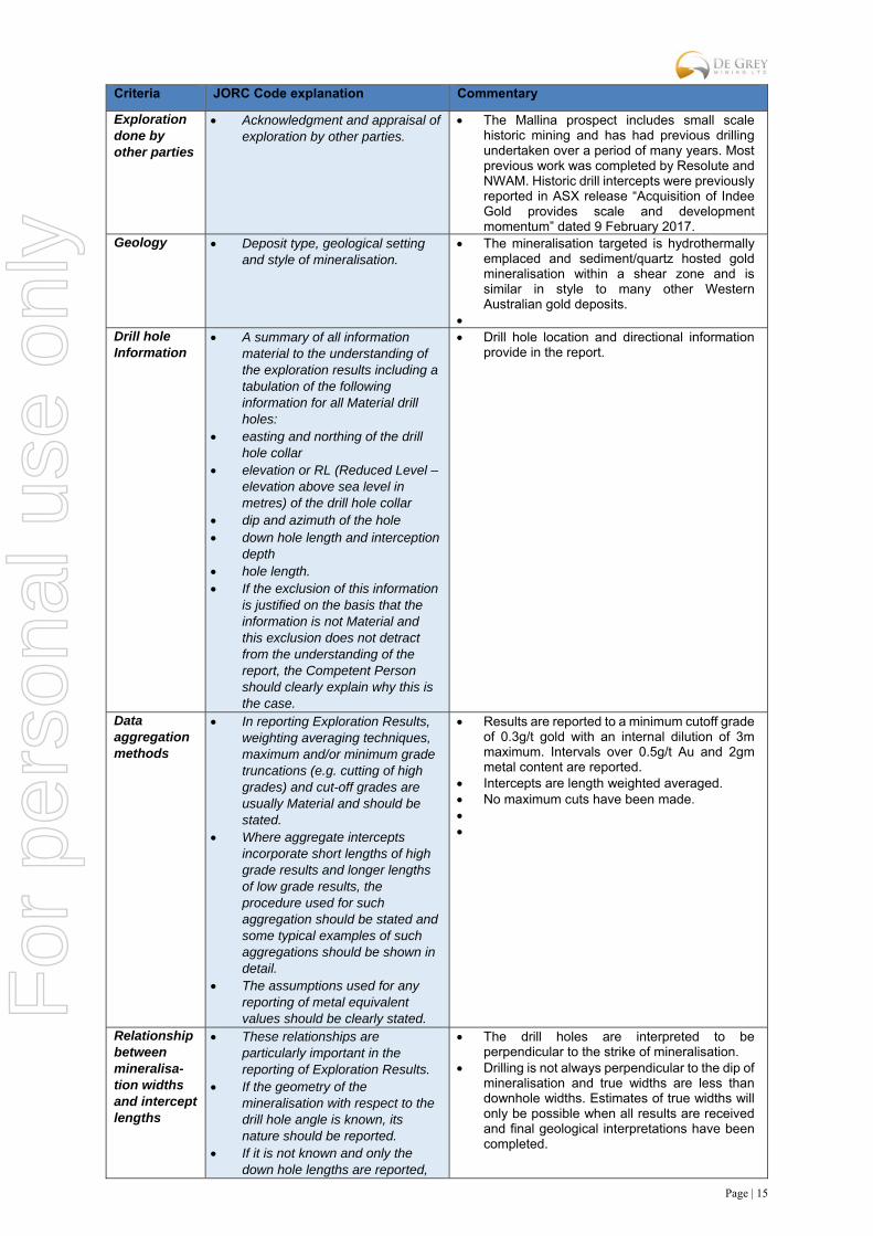
The Mallina prospect includes small scale historic mining and has had previous drilling undertaken over a period of many years. Most previous work was completed by Resolute and NWAM. Historic drill intercepts were previously reported in ASX release “Acquisition of Indee Gold provides scale and development momentum” dated 9 February 2017.
Geology Deposit type, geological setting and style of mineralisation.
The mineralisation targeted is hydrothermally emplaced and sediment/quartz hosted gold mineralisation within a shear zone and is similar in style to many other Western Australian gold deposits.
Drill hole Information
A summary of all information material to the understanding of the exploration results including a tabulation of the following information for all Material drill holes:
easting and northing of the drill hole collar
elevation or RL (Reduced Level – elevation above sea level in metres) of the drill hole collar
dip and azimuth of the hole down hole length and interception
depth hole length. If the exclusion of this information
is justified on the basis that the information is not Material and this exclusion does not detract from the understanding of the report, the Competent Person should clearly explain why this is the case.
Drill hole location and directional information provide in the report.
Data aggregation methods
In reporting Exploration Results, weighting averaging techniques, maximum and/or minimum grade truncations (e.g. cutting of high grades) and cut-off grades are usually Material and should be stated.
Where aggregate intercepts incorporate short lengths of high grade results and longer lengths of low grade results, the procedure used for such aggregation should be stated and some typical examples of such aggregations should be shown in detail.
The assumptions used for any reporting of metal equivalent values should be clearly stated.
Results are reported to a minimum cutoff grade of 0.3g/t gold with an internal dilution of 3m maximum. Intervals over 0.5g/t Au and 2gm metal content are reported.
Intercepts are length weighted averaged. No maximum cuts have been made.
Relationship between mineralisa-tion widths and intercept lengths
These relationships are particularly important in the reporting of Exploration Results.
If the geometry of the mineralisation with respect to the drill hole angle is known, its nature should be reported.
If it is not known and only the down hole lengths are reported,
The drill holes are interpreted to be perpendicular to the strike of mineralisation.
Drilling is not always perpendicular to the dip of mineralisation and true widths are less than downhole widths. Estimates of true widths will only be possible when all results are received and final geological interpretations have been completed.
For
per
sona
l use
onl
y
Page | 16
Criteria JORC Code explanation Commentary
there should be a clear statement to this effect (e.g. ‘down hole length, true width not known’).
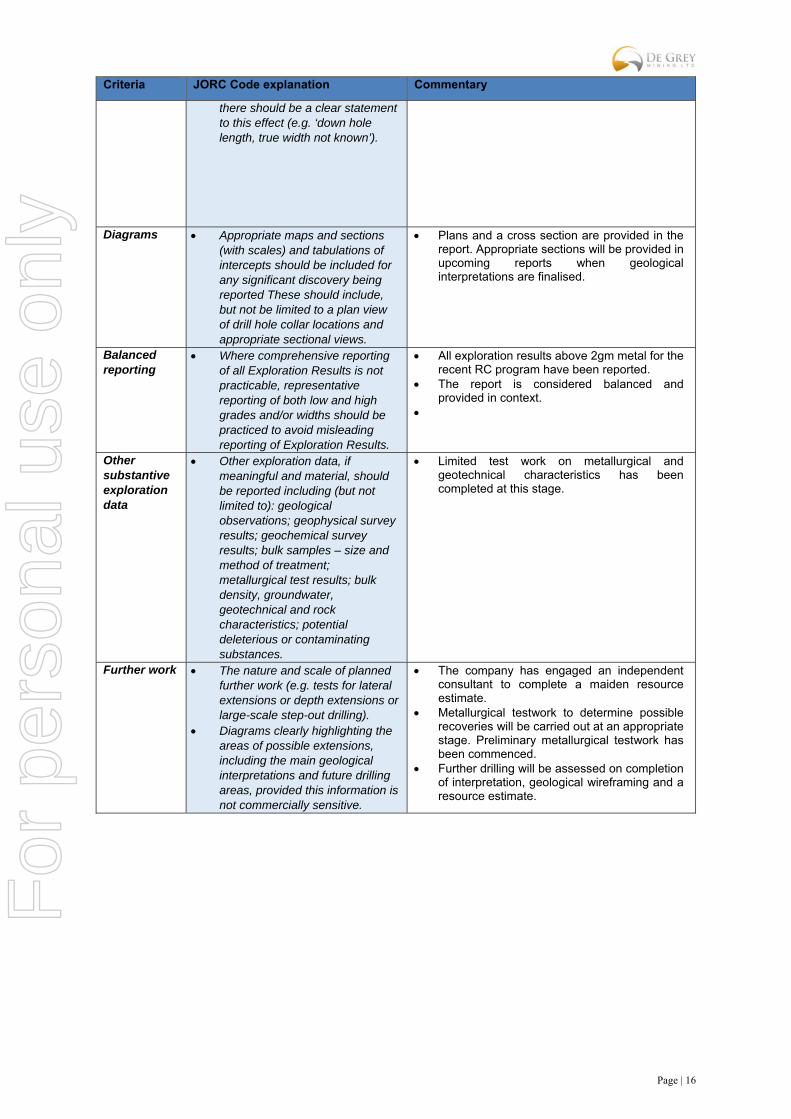
Diagrams Appropriate maps and sections (with scales) and tabulations of intercepts should be included for any significant discovery being reported These should include, but not be limited to a plan view of drill hole collar locations and appropriate sectional views.
Plans and a cross section are provided in the report. Appropriate sections will be provided in upcoming reports when geological interpretations are finalised.
Balanced reporting
Where comprehensive reporting of all Exploration Results is not practicable, representative reporting of both low and high grades and/or widths should be practiced to avoid misleading reporting of Exploration Results.
All exploration results above 2gm metal for the recent RC program have been reported.
The report is considered balanced and provided in context.
Other substantive exploration data
Other exploration data, if meaningful and material, should be reported including (but not limited to): geological observations; geophysical survey results; geochemical survey results; bulk samples – size and method of treatment; metallurgical test results; bulk density, groundwater, geotechnical and rock characteristics; potential deleterious or contaminating substances.
Limited test work on metallurgical and geotechnical characteristics has been completed at this stage.
Further work The nature and scale of planned further work (e.g. tests for lateral extensions or depth extensions or large-scale step-out drilling).
Diagrams clearly highlighting the areas of possible extensions, including the main geological interpretations and future drilling areas, provided this information is not commercially sensitive.
The company has engaged an independent consultant to complete a maiden resource estimate.
Metallurgical testwork to determine possible recoveries will be carried out at an appropriate stage. Preliminary metallurgical testwork has been commenced.
Further drilling will be assessed on completion of interpretation, geological wireframing and a resource estimate.
For
per
sona
l use
onl
y
Page | 17
Section 3 Estimation and Reporting of Mineral Resources
Criteria JORC Code explanation Commentary
Database integrity
Measures taken to ensure that data has not been corrupted by, for example, transcription or keying errors, between its initial collection and its use for Mineral Resource estimation purposes.
Data validation procedures used.
The geological and assay data was captured electronically to prevent transcription errors.
Validation included comparison of gold results to logged geology to verify mineralised intervals.
Site visits Comment on any site visits undertaken by the Competent Person and the outcome of those visits.
If no site visits have been undertaken indicate why this is the case.
A site visit was undertaken by Paul Payne in 2017 to examine geological features in outcrop and mine exposures to locate drill collars from historic drilling and confirm that no obvious impediments to future exploration or development were present.
Geological interpretation
Confidence in (or conversely, the uncertainty of) the geological interpretation of the mineral deposit.
Nature of the data used and of any assumptions made.
The effect, if any, of alternative interpretations on Mineral Resource estimation.
The use of geology in guiding and controlling Mineral Resource estimation.
The factors affecting continuity
both of grade and geology.
The confidence in the geological interpretation for the main central lodes is considered to be high due to the drill spacing and consistent mineralisation.
The interpretation was based largely on good quality RC drilling, with a number of diamond holes.
The deposit consists of moderate to steeply dipping mineralised lodes which have been interpreted based largely on assay data from samples taken at regular intervals from angled drill holes.
Geological logging has been used to define oxide and fresh domains.
An alternative interpretation is unlikely other than in the extensions to the deposits.
Dimensions The extent and variability of the Mineral Resource expressed as length (along strike or otherwise), plan width, and depth below surface to the upper and lower limits of the Mineral Resource.
The mineralisation extends over 3km and comprises multiple mineralised lodes over its 360m width. The main lode has been defined to a depth of 150m.
Estimation and modelling techniques
The nature and appropriateness of the estimation technique(s) applied and key assumptions, including treatment of extreme grade values, domaining, interpolation parameters and maximum distance of extrapolation from data points. If a computer assisted estimation method was chosen include a description of computer software and parameters used.
The availability of check estimates, previous estimates and/or mine production records and whether the Mineral Resource estimate takes appropriate account of such data.
The assumptions made regarding recovery of by-products.
Estimation of deleterious elements or other non-grade variables of economic significance (e.g. sulphur for acid mine drainage characterisation).
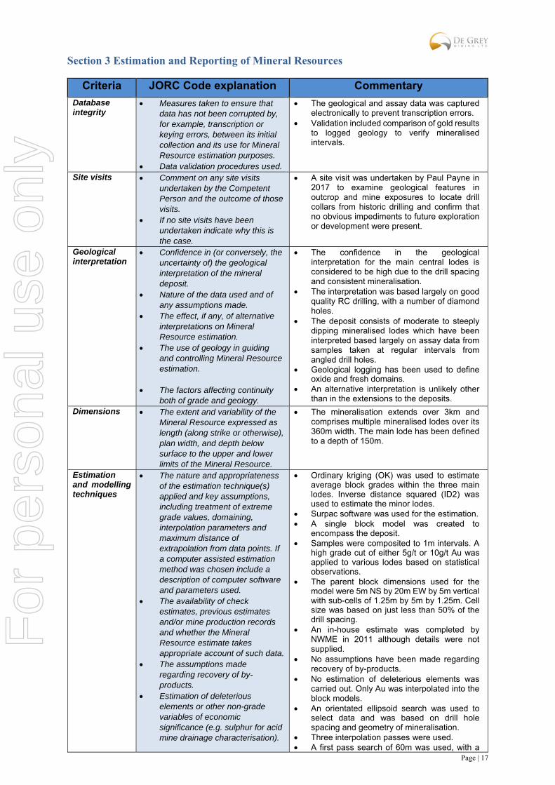
Ordinary kriging (OK) was used to estimate average block grades within the three main lodes. Inverse distance squared (ID2) was used to estimate the minor lodes.
Surpac software was used for the estimation. A single block model was created to
encompass the deposit. Samples were composited to 1m intervals. A
high grade cut of either 5g/t or 10g/t Au was applied to various lodes based on statistical observations.
The parent block dimensions used for the model were 5m NS by 20m EW by 5m vertical with sub-cells of 1.25m by 5m by 1.25m. Cell size was based on just less than 50% of the drill spacing.
An in-house estimate was completed by NWME in 2011 although details were not supplied.
No assumptions have been made regarding recovery of by-products.
No estimation of deleterious elements was carried out. Only Au was interpolated into the block models.
An orientated ellipsoid search was used to select data and was based on drill hole spacing and geometry of mineralisation.
Three interpolation passes were used. A first pass search of 60m was used, with a
For
per
sona
l use
onl
y

Page | 18
Criteria JORC Code explanation Commentary
In the case of block model interpolation, the block size in relation to the average sample spacing and the search employed.
Any assumptions behind modelling of selective mining units.
Any assumptions about correlation between variables.
Description of how the geological interpretation was used to control the resource estimates.
Discussion of basis for using or not using grade cutting or capping.
The process of validation, the checking process used, the comparison of model data to drill hole data, and use of reconciliation data if available.
minimum of 10 samples and a maximum of 24 samples which resulted in 71% of the blocks being estimated. The search radius was increased to 90m for the second pass, and the minimum number of samples reduced to 6 which resulted in a further 26% of blocks being estimated. The remaining 3% of blocks were filled by increasing the search to 120m and by reducing the minimum number of samples to 2.
Selective mining units were not modelled in the Mineral Resource model. The block size used in the model was based on drill sample spacing and lode orientation.
The deposit mineralisation was constrained by wireframes constructed using a 0.3g/t to 0.4g/t Au cut-off grade. The wireframes were applied as hard boundaries in the estimates.
For validation, trend analysis was completed by comparing the interpolated blocks to the sample composite data within easting intervals and by 10m vertical intervals for main lode 1.
Moisture Whether the tonnages are estimated on a dry basis or with natural moisture, and the method of determination of the moisture content.
Tonnages and grades were estimated on a dry in situ basis. No moisture values were reviewed.
Cut-off parameters
The basis of the adopted cut-off grade(s) or quality parameters applied.
The Mineral Resources have been reported at 0.5g/t Au cut-off for material above -50mRL based on assumptions about economic cut-off grades for open pit mining to a depth of 100m.
Mining factors or assumptions
Assumptions made regarding possible mining methods, minimum mining dimensions and internal (or, if applicable, external) mining dilution. It is always necessary as part of the process of determining reasonable prospects for eventual economic extraction to consider potential mining methods, but the assumptions made regarding mining methods and parameters when estimating Mineral Resources may not always be rigorous. Where this is the case, this should be reported with an explanation of the basis of the mining assumptions made.
Based on the previous production history at the Indee Project and the shallow, outcropping nature of the mineralisation, it is assumed that open pit mining is possible at the project if demonstrated to be economically viable.
No mining parameters or modifying factors have been applied to the Mineral Resource.
Metallurgical factors or assumptions
The basis for assumptions or predictions regarding metallurgical amenability. It is always necessary as part of the process of determining reasonable prospects for eventual economic extraction to consider potential metallurgical methods, but the assumptions regarding metallurgical treatment processes and parameters made when reporting Mineral Resources may not always be rigorous. Where this is the case,
No assumption regarding metallurgical methods have been made.
Gold production from a heap leach operation at an adjacent deposit within the Indee Project area confirmed that the oxide mineralisation is amenable to cyanide leaching.
Further work is planned to clarify processing options for the primary mineralisation.
For
per
sona
l use
onl
y

Page | 19
Criteria JORC Code explanation Commentary
this should be reported with an explanation of the basis of the metallurgical assumptions made.
Environmental factors or assumptions
Assumptions made regarding possible waste and process residue disposal options. It is always necessary as part of the process of determining reasonable prospects for eventual economic extraction to consider the potential environmental impacts of the mining and processing operation. While at this stage the determination of potential environmental impacts, particularly for a greenfields project, may not always be well advanced, the status of early consideration of these potential environmental impacts should be reported. Where these aspects have not been considered this should be reported with an explanation of the environmental assumptions made.
The area is not known to be environmentally sensitive and there is no reason to think that proposals for development including the dumping of waste would not be approved.
The Indee area is already highly disturbed with previous permitting granted for open pit mining and processing.
The area surrounding the Indee deposit is generally flat and uninhabited with no obvious impediments to the construction of dumps and other mine infrastructure.
Bulk density Whether assumed or determined. If assumed, the basis for the assumptions. If determined, the method used, whether wet or dry, the frequency of the measurements, the nature, size and representativeness of the samples.
The bulk density for bulk material must have been measured by methods that adequately account for void spaces (vugs, porosity, etc.), moisture and differences between rock and alteration zones within the deposit.
Discuss assumptions for bulk density estimates used in the evaluation process of the different materials.
Bulk density values were based on test work from drill core at adjacent deposits within the Indee Project area.
A bulk density of 2.3t/m3 was applied to oxide material, and 2.6t/m3 applied to primary sulphide material. No transitional material has been recorded at the deposit.
Classification The basis for the classification of the Mineral Resources into varying confidence categories.
Whether appropriate account has been taken of all relevant factors (i.e. relative confidence in tonnage/grade estimations, reliability of input data, confidence in continuity of geology and metal values, quality, quantity and distribution of the data).
Whether the result appropriately reflects the Competent Person’s view of the deposit.
Mineral Resources were classified in accordance with the Australasian Code for the Reporting of Exploration Results, Mineral Resources and Ore Reserves (JORC, 2012). The Mineral Resources were classified as Indicated and Inferred Mineral Resource on the basis of data quality, sample spacing, and lode continuity.
The two main central lodes at Mallina have been defined by a drill spacing of 50m sections and 20m hole spacing on each section. The areas showing good continuity of mineralisation along these lodes have been classified as Indicated Mineral Resource. The remaining lodes at Mallina have been defined by single sections of drilling, or show poor continuity along strike, and have been classified as Inferred Mineral Resource.
The deposits have been reviewed by the Competent Person. Where detailed data is
For
per
sona
l use
onl
y
Page | 20
Criteria JORC Code explanation Commentary
available, the results reflect the view of the Competent Person.
Audits or reviews
The results of any audits or reviews of Mineral Resource estimates.
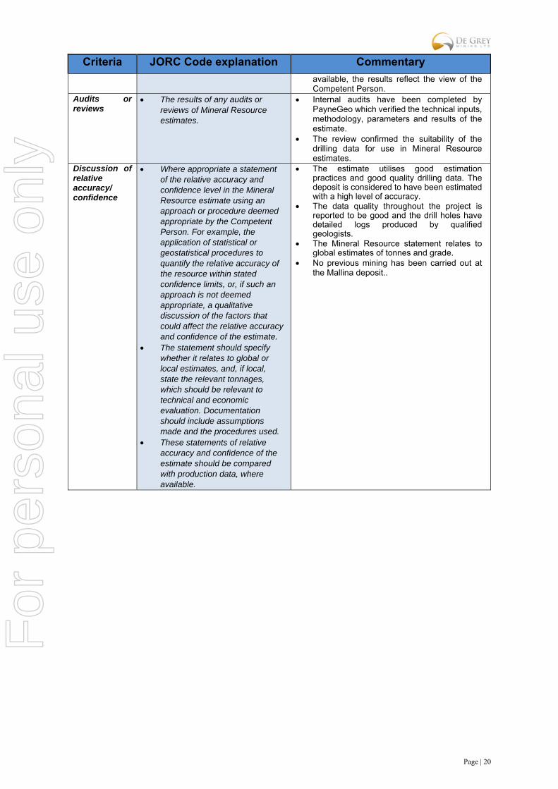
Internal audits have been completed by PayneGeo which verified the technical inputs, methodology, parameters and results of the estimate.
The review confirmed the suitability of the drilling data for use in Mineral Resource estimates.
Discussion of relative accuracy/ confidence
Where appropriate a statement of the relative accuracy and confidence level in the Mineral Resource estimate using an approach or procedure deemed appropriate by the Competent Person. For example, the application of statistical or geostatistical procedures to quantify the relative accuracy of the resource within stated confidence limits, or, if such an approach is not deemed appropriate, a qualitative discussion of the factors that could affect the relative accuracy and confidence of the estimate.
The statement should specify whether it relates to global or local estimates, and, if local, state the relevant tonnages, which should be relevant to technical and economic evaluation. Documentation should include assumptions made and the procedures used.
These statements of relative accuracy and confidence of the estimate should be compared with production data, where available.
The estimate utilises good estimation practices and good quality drilling data. The deposit is considered to have been estimated with a high level of accuracy.
The data quality throughout the project is reported to be good and the drill holes have detailed logs produced by qualified geologists.
The Mineral Resource statement relates to global estimates of tonnes and grade.
No previous mining has been carried out at the Mallina deposit..
For
per
sona
l use
onl
y
Page | 21
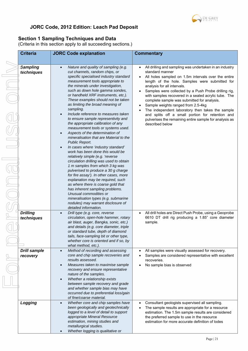
JORC Code, 2012 Edition: Leach Pad Deposit
Section 1 Sampling Techniques and Data (Criteria in this section apply to all succeeding sections.)
Criteria
JORC Code explanation Commentary
Sampling techniques
Nature and quality of sampling (e.g. cut channels, random chips, or specific specialised industry standard measurement tools appropriate to the minerals under investigation, such as down hole gamma sondes, or handheld XRF instruments, etc.). These examples should not be taken as limiting the broad meaning of sampling.
Include reference to measures taken to ensure sample representivity and the appropriate calibration of any measurement tools or systems used.
Aspects of the determination of mineralisation that are Material to the Public Report.
In cases where ‘industry standard’ work has been done this would be relatively simple (e.g. ‘reverse circulation drilling was used to obtain 1 m samples from which 3 kg was pulverised to produce a 30 g charge for fire assay’). In other cases, more explanation may be required, such as where there is coarse gold that has inherent sampling problems. Unusual commodities or mineralisation types (e.g. submarine nodules) may warrant disclosure of detailed information.
All drilling and sampling was undertaken in an industry standard manner
All holes sampled on 1.5m intervals over the entire length of the hole. Samples were submitted for analysis for all intervals.
Samples were collected by a Push Probe drilling rig, with samples recovered in a sealed acrylic tube. The complete sample was submitted for analysis.
Sample weights ranged from 2.5-4kg The independent laboratory then takes the sample
and splits off a small portion for retention and pulverises the remaining entire sample for analysis as described below
Drilling techniques
Drill type (e.g. core, reverse circulation, open-hole hammer, rotary air blast, auger, Bangka, sonic, etc.) and details (e.g. core diameter, triple or standard tube, depth of diamond tails, face-sampling bit or other type, whether core is oriented and if so, by what method, etc.).
All drill holes are Direct Push Probe, using a Geoprobe 6610 DT drill rig producing a 1.85” core diameter sample.
Drill sample recovery
Method of recording and assessing core and chip sample recoveries and results assessed.
Measures taken to maximise sample recovery and ensure representative nature of the samples.
Whether a relationship exists between sample recovery and grade and whether sample bias may have occurred due to preferential loss/gain of fine/coarse material.
All samples were visually assessed for recovery. Samples are considered representative with excellent
recoveries. No sample bias is observed
Logging Whether core and chip samples have been geologically and geotechnically logged to a level of detail to support appropriate Mineral Resource estimation, mining studies and metallurgical studies.
Whether logging is qualitative or
Consultant geologists supervised all sampling. The sample results are appropriate for a resource
estimation. The 1.5m sample results are considered the preferred sample to use in the resource estimation for more accurate definition of lodes
For
per
sona
l use
onl
y

Page | 22
Criteria
JORC Code explanation Commentary
quantitative in nature. Core (or costean, channel, etc.) photography.
The total length and percentage of the relevant intersections logged.
Sub-sampling techniques and sample preparation
If core, whether cut or sawn and whether quarter, half or all core taken.
If non-core, whether riffled, tube sampled, rotary split, etc. and whether sampled wet or dry.
For all sample types, the nature, quality and appropriateness of the sample preparation technique.
Quality control procedures adopted for all sub-sampling stages to maximise representivity of samples.
Measures taken to ensure that the sampling is representative of the in situ material collected, including for instance results for field duplicate/second-half sampling.
Whether sample sizes are appropriate to the grain size of the material being sampled.
Samples were collected by a Push Probe drilling rig, with samples recovered in 1.5m intervals in a sealed acrylic tube.
Independent standard reference material was inserted approximately every 20 samples
Two drill holes were twinned and analyses between holes compared
The samples are considered representative and appropriate for this type of drilling and for use in a resource estimate.
Quality of assay data and laboratory tests
The nature, quality and appropriateness of the assaying and laboratory procedures used and whether the technique is considered partial or total.
For geophysical tools, spectrometers, handheld XRF instruments, etc., the parameters used in determining the analysis including instrument make and model, reading times, calibrations factors applied and their derivation, etc.
Nature of quality control procedures adopted (e.g. standards, blanks, duplicates, external laboratory checks) and whether acceptable levels of accuracy (i.e. lack of bias) and precision have been established.
The samples were submitted to a commercial independent laboratory in Perth, Australia.
Each sample was dried, split, crushed and pulverised.
Au was analysed by a 50gm charge Fire assay fusion technique with a AAS finish
The techniques are considered quantitative in nature.
As discussed previously certified reference standards were inserted by the Company and the laboratory also carries out internal standards in individual batches
The standards and duplicates were considered satisfactory
Verification of sampling and assaying
The verification of significant intersections by either independent or alternative company personnel.
The use of twinned holes. Documentation of primary data, data
entry procedures, data verification, data storage (physical and electronic) protocols.
Discuss any adjustment to assay data.
Sample results have been merged by the company’s database consultants
Results have been uploaded into the company database, checked and verified
No adjustments have been made to the assay data. Results are reported on a length weighted basis
Location of data points
Accuracy and quality of surveys used to locate drill holes (collar and down-hole surveys), trenches, mine workings and other locations used in Mineral Resource estimation.
Specification of the grid system used. Quality and adequacy of topographic
control.
Drill hole collar locations are located by DGPS to an accuracy of +/-10cm.
Locations are given in GDA94 zone 50 projection Diagrams and location table are provided in the
report
For
per
sona
l use
onl
y

Page | 23
Criteria
JORC Code explanation Commentary
Data spacing and distribution
Data spacing for reporting of Exploration Results.
Whether the data spacing and distribution is sufficient to establish the degree of geological and grade continuity appropriate for the Mineral Resource and Ore Reserve estimation procedure(s) and classifications applied.
Whether sample compositing has been applied.
The Push Probe drilling is on a 40m x 20m grid pattern.
All holes have been geologically inspected. Material on the leach pad has been crushed to <25mm and distributed in sweeps and is therefore partially homogenized.
Sample result and logging will provide strong support for the results to be used in a resource estimate
Orientation of data in relation to geological structure
Whether the orientation of sampling achieves unbiased sampling of possible structures and the extent to which this is known, considering the deposit type.
If the relationship between the drilling orientation and the orientation of key mineralised structures is considered to have introduced a sampling bias, this should be assessed and reported if material.
The drilling was vertical sampling and is considered representative of the leach pad material.
Relation to mineralised structures is not relevant in this case since the ore has been crushed and redistributed across the leach pad.
Vertical drill holes should provide a representative indication of mineralisation present.
Sample security
The measures taken to ensure sample security.
Samples were collected by company personnel and delivered direct to the laboratory via a transport contractor
Audits or reviews
The results of any audits or reviews of sampling techniques and data.
No audits have been completed. Review of QAQC data has been carried out by company geologists and the resource consultant.
Section 2 Reporting of Exploration Results (Criteria listed in the preceding section also apply to this section.)
Criteria JORC Code explanation Commentary
Mineral tenement and land tenure status
Type, reference name/number, location and ownership including agreements or material issues with third parties such as joint ventures, partnerships, overriding royalties, native title interests, historical sites, wilderness or national park and environmental settings.
The security of the tenure held at the time of reporting along with any known impediments to obtaining a license to operate in the area.
The drilling is on M47/475 which is located approximately 80km south of Port Hedland. The tenement is held by Indee Gold Pty Ltd, which De Grey mining has an option to purchase 100%. De Grey has the right to acquire Indee Gold for payment of $15M by July 2018.
Exploration done by other parties
Acknowledgment and appraisal of exploration by other parties.
Extensive drilling of the Indee orebodies leading to the definition of Ore Reserves and the development of a mining and processing operation was carried out mainly by Range River between 2003 and 2008.
Material on the heap leach pad was mined from the Withnell and Camel pits by Range River.
Geology Deposit type, geological setting and style of mineralisation.
The mineralisation targeted is hydrothermally emplaced and sediment/quartz hosted gold mineralisation within a shear zone and is similar in style to many other Western Australian gold deposits.
This material has been mined in open pit operations and dumped on the leach pad
For
per
sona
l use
onl
y
Page | 24
Criteria JORC Code explanation Commentary
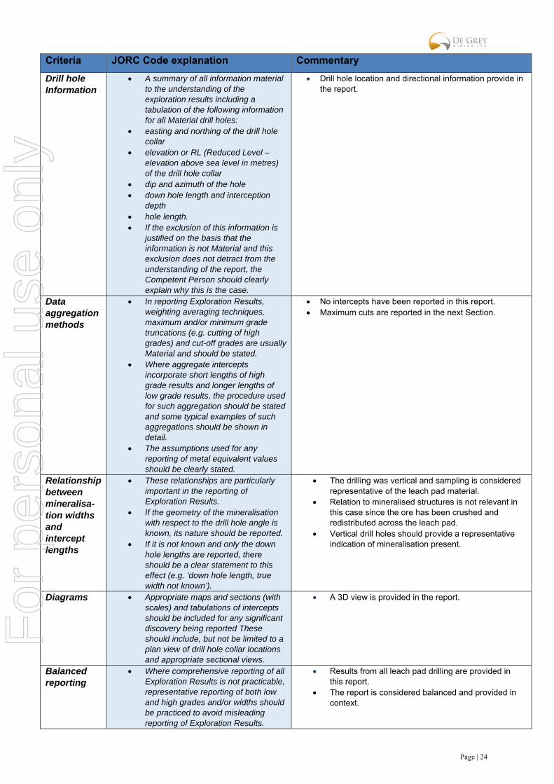
Drill hole Information
A summary of all information material to the understanding of the exploration results including a tabulation of the following information for all Material drill holes:
easting and northing of the drill hole collar
elevation or RL (Reduced Level – elevation above sea level in metres) of the drill hole collar
dip and azimuth of the hole down hole length and interception
depth hole length. If the exclusion of this information is
justified on the basis that the information is not Material and this exclusion does not detract from the understanding of the report, the Competent Person should clearly explain why this is the case.
Drill hole location and directional information provide in the report.
Data aggregation methods
In reporting Exploration Results, weighting averaging techniques, maximum and/or minimum grade truncations (e.g. cutting of high grades) and cut-off grades are usually Material and should be stated.
Where aggregate intercepts incorporate short lengths of high grade results and longer lengths of low grade results, the procedure used for such aggregation should be stated and some typical examples of such aggregations should be shown in detail.
The assumptions used for any reporting of metal equivalent values should be clearly stated.
No intercepts have been reported in this report. Maximum cuts are reported in the next Section.
Relationship between mineralisa-tion widths and intercept lengths
These relationships are particularly important in the reporting of Exploration Results.
If the geometry of the mineralisation with respect to the drill hole angle is known, its nature should be reported.
If it is not known and only the down hole lengths are reported, there should be a clear statement to this effect (e.g. ‘down hole length, true width not known’).
The drilling was vertical and sampling is considered representative of the leach pad material.
Relation to mineralised structures is not relevant in this case since the ore has been crushed and redistributed across the leach pad.
Vertical drill holes should provide a representative indication of mineralisation present.
Diagrams Appropriate maps and sections (with scales) and tabulations of intercepts should be included for any significant discovery being reported These should include, but not be limited to a plan view of drill hole collar locations and appropriate sectional views.
A 3D view is provided in the report.
Balanced reporting
Where comprehensive reporting of all Exploration Results is not practicable, representative reporting of both low and high grades and/or widths should be practiced to avoid misleading reporting of Exploration Results.
Results from all leach pad drilling are provided in this report.
The report is considered balanced and provided in context.
For
per
sona
l use
onl
y
Page | 25
Criteria JORC Code explanation Commentary
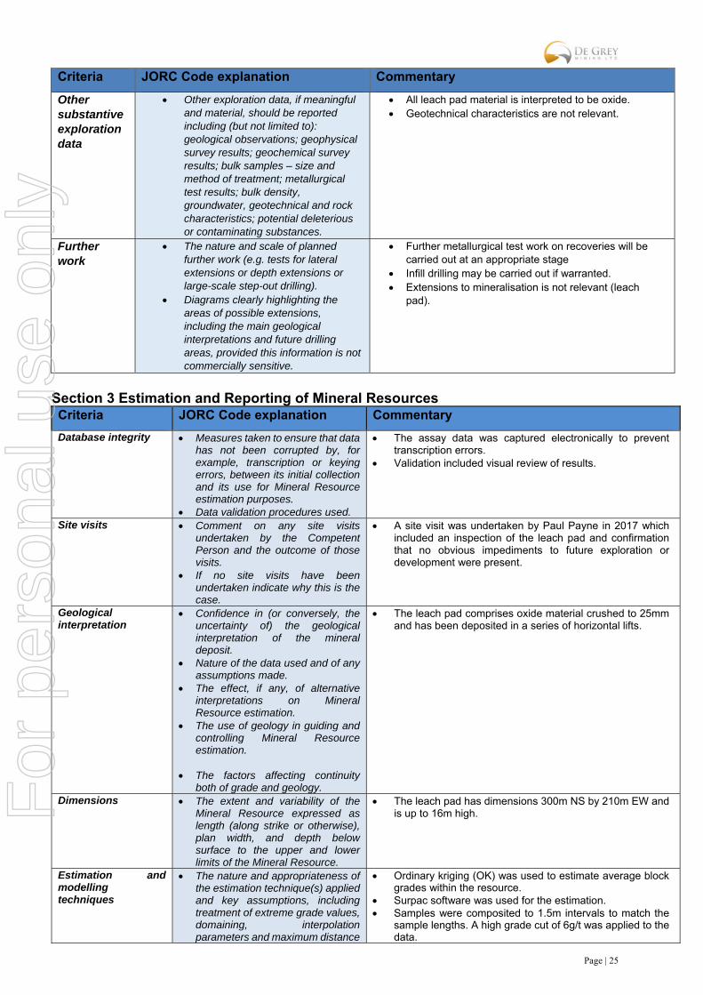
Other substantive exploration data
Other exploration data, if meaningful and material, should be reported including (but not limited to): geological observations; geophysical survey results; geochemical survey results; bulk samples – size and method of treatment; metallurgical test results; bulk density, groundwater, geotechnical and rock characteristics; potential deleterious or contaminating substances.
All leach pad material is interpreted to be oxide. Geotechnical characteristics are not relevant.
Further work
The nature and scale of planned further work (e.g. tests for lateral extensions or depth extensions or large-scale step-out drilling).
Diagrams clearly highlighting the areas of possible extensions, including the main geological interpretations and future drilling areas, provided this information is not commercially sensitive.
Further metallurgical test work on recoveries will be carried out at an appropriate stage
Infill drilling may be carried out if warranted. Extensions to mineralisation is not relevant (leach
pad).
Section 3 Estimation and Reporting of Mineral Resources Criteria JORC Code explanation Commentary
Database integrity Measures taken to ensure that data has not been corrupted by, for example, transcription or keying errors, between its initial collection and its use for Mineral Resource estimation purposes.
Data validation procedures used.
The assay data was captured electronically to prevent transcription errors.
Validation included visual review of results.
Site visits Comment on any site visits undertaken by the Competent Person and the outcome of those visits.
If no site visits have been undertaken indicate why this is the case.
A site visit was undertaken by Paul Payne in 2017 which included an inspection of the leach pad and confirmation that no obvious impediments to future exploration or development were present.
Geological interpretation
Confidence in (or conversely, the uncertainty of) the geological interpretation of the mineral deposit.
Nature of the data used and of any assumptions made.
The effect, if any, of alternative interpretations on Mineral Resource estimation.
The use of geology in guiding and controlling Mineral Resource estimation.
The factors affecting continuity
both of grade and geology.
The leach pad comprises oxide material crushed to 25mm and has been deposited in a series of horizontal lifts.
Dimensions The extent and variability of the Mineral Resource expressed as length (along strike or otherwise), plan width, and depth below surface to the upper and lower limits of the Mineral Resource.
The leach pad has dimensions 300m NS by 210m EW and is up to 16m high.
Estimation and modelling techniques
The nature and appropriateness of the estimation technique(s) applied and key assumptions, including treatment of extreme grade values, domaining, interpolation parameters and maximum distance
Ordinary kriging (OK) was used to estimate average block grades within the resource.
Surpac software was used for the estimation. Samples were composited to 1.5m intervals to match the
sample lengths. A high grade cut of 6g/t was applied to the data.
For
per
sona
l use
onl
y
Page | 26
Criteria JORC Code explanation Commentary
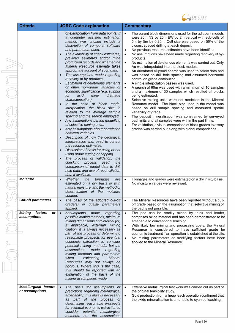
of extrapolation from data points. If a computer assisted estimation method was chosen include a description of computer software and parameters used.
The availability of check estimates, previous estimates and/or mine production records and whether the Mineral Resource estimate takes appropriate account of such data.
The assumptions made regarding recovery of by-products.
Estimation of deleterious elements or other non-grade variables of economic significance (e.g. sulphur for acid mine drainage characterisation).
In the case of block model interpolation, the block size in relation to the average sample spacing and the search employed.
Any assumptions behind modelling of selective mining units.
Any assumptions about correlation between variables.
Description of how the geological interpretation was used to control the resource estimates.
Discussion of basis for using or not using grade cutting or capping.
The process of validation, the checking process used, the comparison of model data to drill hole data, and use of reconciliation data if available.
The parent block dimensions used for the adjacent models were 20m NS by 20m EW by 2m vertical with sub-cells of 5m by 5m by 0.25m. Cell size was based on 50% of the closest spaced drilling at each deposit.
No previous resource estimates have been identified. No assumptions have been made regarding recovery of by-
products. No estimation of deleterious elements was carried out. Only
Au was interpolated into the block models. An orientated ellipsoid search was used to select data and
was based on drill hole spacing and assumed horizontal control on grade distribution.
A single interpolation passes was used. A search of 60m was used with a minimum of 10 samples
and a maximum of 30 samples which resulted all blocks being estimated.
Selective mining units were not modelled in the Mineral Resource model. The block size used in the model was based on drill sample spacing and measured spatial variability of grade.
The deposit mineralisation was constrained by surveyed pad limits and all samples were within the pad limits.
For validation, a visual comparison of block grades to assay grades was carried out along with global comparisons.
Moisture Whether the tonnages are estimated on a dry basis or with natural moisture, and the method of determination of the moisture content.
Tonnages and grades were estimated on a dry in situ basis. No moisture values were reviewed.
Cut-off parameters The basis of the adopted cut-off grade(s) or quality parameters applied.
The Mineral Resources have been reported without a cut-off grade based on the assumption that selective mining of the pad is not possible.
Mining factors or assumptions
Assumptions made regarding possible mining methods, minimum mining dimensions and internal (or, if applicable, external) mining dilution. It is always necessary as part of the process of determining reasonable prospects for eventual economic extraction to consider potential mining methods, but the assumptions made regarding mining methods and parameters when estimating Mineral Resources may not always be rigorous. Where this is the case, this should be reported with an explanation of the basis of the mining assumptions made.
The pad can be readily mined by truck and loader, comprises oxide material and has been demonstrated to be amenable to conventional leaching.
With likely low mining and processing costs, the Mineral Resource is considered to have sufficient grade for economic treatment if an operation is established at the site.
No mining parameters or modifying factors have been applied to the Mineral Resource.
Metallurgical factors or assumptions
The basis for assumptions or predictions regarding metallurgical amenability. It is always necessary as part of the process of determining reasonable prospects for eventual economic extraction to consider potential metallurgical methods, but the assumptions
Extensive metallurgical test work was carried out as part of the original feasibility study.
Gold production from a heap leach operation confirmed that the oxide mineralisation is amenable to cyanide leaching.
For
per
sona
l use
onl
y
Page | 27
Criteria JORC Code explanation Commentary
regarding metallurgical treatment processes and parameters made when reporting Mineral Resources may not always be rigorous. Where this is the case, this should be reported with an explanation of the basis of the metallurgical assumptions made.
Environmental factors or assumptions
Assumptions made regarding possible waste and process residue disposal options. It is always necessary as part of the process of determining reasonable prospects for eventual economic extraction to consider the potential environmental impacts of the mining and processing operation. While at this stage the determination of potential environmental impacts, particularly for a greenfields project, may not always be well advanced, the status of early consideration of these potential environmental impacts should be reported. Where these aspects have not been considered this should be reported with an explanation of the environmental assumptions made.
The area is not known to be environmentally sensitive and there is no reason to think that proposals for development including the dumping of waste would not be approved.
The Indee area is already highly disturbed with previous permitting granted for open pit mining and processing.
The area surrounding the Indee deposit is generally flat and uninhabited with no obvious impediments to the construction of dumps and other mine infrastructure.
Bulk density Whether assumed or determined. If assumed, the basis for the assumptions. If determined, the method used, whether wet or dry, the frequency of the measurements, the nature, size and representativeness of the samples.
The bulk density for bulk material must have been measured by methods that adequately account for void spaces (vugs, porosity, etc), moisture and differences between rock and alteration zones within the deposit.
Discuss assumptions for bulk density estimates used in the evaluation process of the different materials.
A bulk density value of 1.6t/m3 was based on an assumed value applicable to compacted aggregate.
Classification The basis for the classification of the Mineral Resources into varying confidence categories.
Whether appropriate account has been taken of all relevant factors (i.e. relative confidence in tonnage/grade estimations, reliability of input data, confidence in continuity of geology and metal values, quality, quantity and distribution of the data).
Whether the result appropriately reflects the Competent Person’s view of the deposit.
The Mineral Resources was classified in accordance with the Australasian Code for the Reporting of Exploration Results, Mineral Resources and Ore Reserves (JORC, 2012).
The entire Mineral Resource was classified as Indicated on the basis of data quality, sample spacing, and grade variability.
The deposit has been reviewed by the Competent Person and the results reflect the view of the Competent Person.
Audits or reviews The results of any audits or reviews of Mineral Resource estimates.
No audits or reviews have been carried out
Discussion of relative accuracy/ confidence
Where appropriate a statement of the relative accuracy and confidence level in the Mineral
The estimate utilised good estimation practices, high quality drilling, sampling and assay data. The extent and dimensions of the pad are very accurately defined. The
For
per
sona
l use
onl
y
Page | 28
Criteria JORC Code explanation Commentary
Resource estimate using an approach or procedure deemed appropriate by the Competent Person. For example, the application of statistical or geostatistical procedures to quantify the relative accuracy of the resource within stated confidence limits, or, if such an approach is not deemed appropriate, a qualitative discussion of the factors that could affect the relative accuracy and confidence of the estimate.
The statement should specify whether it relates to global or local estimates, and, if local, state the relevant tonnages, which should be relevant to technical and economic evaluation. Documentation should include assumptions made and the procedures used.
These statements of relative accuracy and confidence of the estimate should be compared with production data, where available.
deposit is considered to have been estimated with a high level of accuracy.
The Mineral Resource statement relates to global estimates of tonnes and grade.
Review of historic production records supports the estimated tonnage and grade of the Mineral Resource.
For
per
sona
l use
onl
y
Page | 29
JORC Code, 2012 Edition: Toweranna Deposit
Section 1 Sampling Techniques and Data (Criteria in this section apply to all succeeding sections.)
Criteria JORC Code explanation Commentary
Sampling techniques Nature and quality of sampling (e.g. cut channels, random chips, or specific specialised industry standard measurement tools appropriate to the minerals under investigation, such as down hole gamma sondes, or handheld XRF instruments, etc.). These examples should not be taken as limiting the broad meaning of sampling.
Include reference to measures taken to ensure sample representivity and the appropriate calibration of any measurement tools or systems used.
Aspects of the determination of mineralisation that are Material to the Public Report.
In cases where ‘industry standard’ work has been done this would be relatively simple (e.g. ‘reverse circulation drilling was used to obtain 1 m samples from which 3 kg was pulverised to produce a 30 g charge for fire assay’). In other cases, more explanation may be required, such as where there is coarse gold that has inherent sampling problems. Unusual commodities or mineralisation types (e.g. submarine nodules) may warrant disclosure of detailed information.
Historical sampling at Toweranna has included cut channels, soil samples, rock grab samples, RC, diamond, and RAB samples. Reports indicate that sampling was carried out by competent geologists following industry best practice.
All diamond holes were sampled at 1m or to mineralisation/geological contacts of less than 1m. Originally half core was sampled for analysis, but subsequent drilling submitted the entire core. Only a few holes were sampled over the entire length.
Earliest samples from 1970 diamond drilling were submitted to Associated Laboratories Australia Pty Ltd. in Perth. Original half core samples were crushed to 0.25 inch aggregate and split using a riffle splitter. A representative fraction (250g) was pulverised to about 80 mesh size. 5g portions were used for aqua regia digest. After solvent extraction with MIBK the gold rich solutions were analysed on a Varian-Techtron AA5 atomic absorption spectrophotometer with results in dwt/long tons.
Investigations in 1974 noted that previous assays were not reliable and seriously under-estimated gold content due to the coarse grained nature of the gold, the small diameter of the core (split core for assay), and unsuitable assay techniques. Additional samples (19 in total) were taken for further analysis by fire assaying using a 32g split. Results of the investigation resulted in all future core being sent whole for analysis by fire assay.
RC samples were generally submitted as 2m composites with anomalous intervals re-submitted as 1m samples.
For Swan drilling in 1993 samples were collected over 1m intervals by means of a rig mounted multi splitter. The splitter produced three fractions in the ratio 50:37.5:12.5. The 12.5% split was collected and run by hand through a single stage splitter. Composite samples over 2m intervals were prepared by placing adjacent samples into the same calico bag for a sample weight of 2 to 5kg. The residues from each 1m sample were reconstituted into a single plastic bag. The 2m composite samples were sent to MultiLabs for fire assay of a 50g charge with an AAS finish. Mineralised intersections were re-submitted as original 1m samples for analysis using the same techniques.
Two RC drill holes were completed by Tindals in 1994 with drilling completed by Charter Drilling using a 4.25 inch hammer. Cuttings were collected into a plastic bag beneath an on-rig cyclone. The cuttings were sampled at 1m intervals hand split using a 12.5/87.5 multistage Metralcraft Aust P/L splitter. The 1/8 sample split which weighed from 2kg to 5kg was placed into a calico bag. The remainder of the cuttings were collected into a plastic bag. In 1994, Tindals submitted 1m samples to Genalysis Laboratory in Perth. Each sample was reduced to nominal -75micron in a single pass using a mixermill. A 50g split was collected and fire assayed using aqua regia digest and reading by AAS method.
A total of 20 RC drill holes were completed by Tindals in 1995 utilising Swick Drilling (Aust) Pty Ltd using an Ingersoll Rand TH-60 top drive rig employing a down hole hammer with a 5.25 inch hollow faced bit and reverse circulation rod string. For TRC prefix holes, samples were collected over 1m intervals by means of a rig mounted multi splitter. The splitter produced three
For
per
sona
l use
onl
y
Page | 30
Criteria JORC Code explanation Commentary
fractions in the ratio 50:37.5:12.5. The 12.5% split was collected and run by hand through a single stage splitter. Composite samples over 2m intervals were prepared by placing adjacent samples into the same calico bag for a sample weight of 2 to 5kg. The residues from each 1m sample were reconstituted into a single plastic bag. For non-TRC prefix holes, sampling received the same treatment but cuttings were collected directly into large plastic bags and sampled using a 50mm thin open plastic tube pushed from the top to bottom of the bag to produce 2m composites. The 2m composite samples were sent to Ultratrace Laboratory. Samples were sorted, dried, and pulverised. A 50g portion was then fired and read by ICP (Optical Emission Spectrometry) for gold, platinum, and palladium. A total of 123 samples were selected to be tested by another laboratory (Genalysis). Sample rejects of the selected samples were 50g split, fire assayed, and the prill dissolved by aqua regia with AAS finish. Both labs ran checks of results above 1g/t as routine.
Drilling techniques Drill type (e.g. core, reverse circulation, open-hole hammer, rotary air blast, auger, Bangka, sonic, etc.) and details (e.g. core diameter, triple or standard tube, depth of diamond tails, face-sampling bit or other type, whether core is oriented and if so, by what method, etc.).
Drilling has been either diamond core, RC or RAB. Diamond drilling by Taurus in 1985 used HQ core to a
depth of approximately 15m and then NQ core was used to end of hole. No other information has been provided regarding diamond drilling by other owners.
RC drilling utilised 4.25 or 5.25 inch hammers.
Drill sample recovery Method of recording and assessing core and chip sample recoveries and results assessed.
Measures taken to maximise sample recovery and ensure representative nature of the samples.
Whether a relationship exists between sample recovery and grade and whether sample bias may have occurred due to preferential loss/gain of fine/coarse material.
All samples were visually assessed for recovery. The competent nature of core resulted in good recoveries as noted in the hand written drill logs.
Good recoveries for RC have been assumed based on the weights of the samples sent for analysis.
No sample bias was observed.
Logging Whether core and chip samples have been geologically and geotechnically logged to a level of detail to support appropriate Mineral Resource estimation, mining studies and metallurgical studies.
Whether logging is qualitative or quantitative in nature. Core (or costean, channel, etc.) photography.
The total length and percentage of the relevant intersections logged.
Historical drill logs have been preserved in digital copies. Detailed drill logs have been produced by qualified geologists to an appropriate level for use in a Mineral Resource estimation.
Logging is qualitative in nature. Historical drill chips placed in plastic trays representing
20m lengths, have been photographed for some earlier RC holes and have verified the logging.
The entire hole was logged.
Sub-sampling techniques and sample preparation
If core, whether cut or sawn and whether quarter, half or all core taken.
Original core samples were cut in half, with one side sent for analysis. Due to the recognition of possible coarse gold at the deposit, subsequent programs sent the entire core sample for analysis.
For
per
sona
l use
onl
y
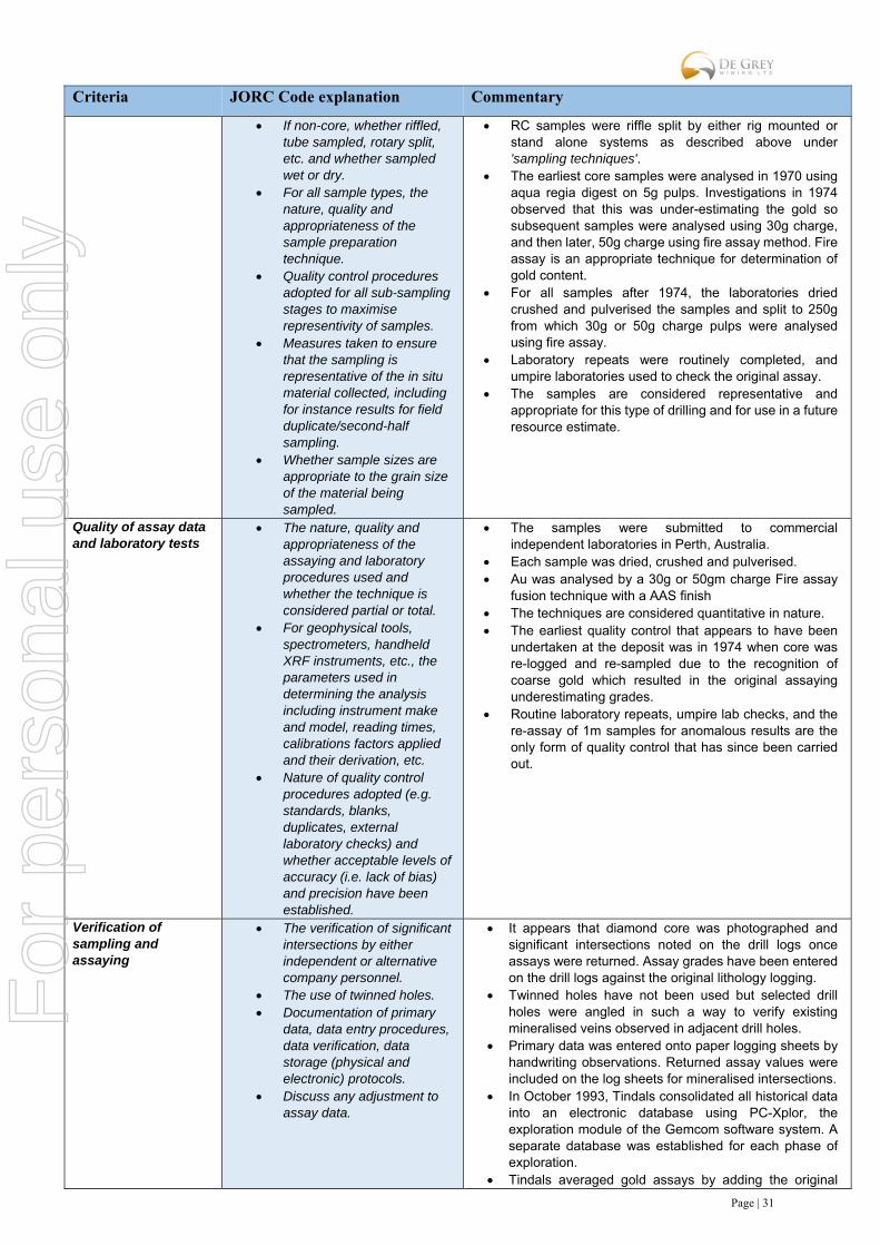
Page | 31
Criteria JORC Code explanation Commentary
If non-core, whether riffled, tube sampled, rotary split, etc. and whether sampled wet or dry.
For all sample types, the nature, quality and appropriateness of the sample preparation technique.
Quality control procedures adopted for all sub-sampling stages to maximise representivity of samples.
Measures taken to ensure that the sampling is representative of the in situ material collected, including for instance results for field duplicate/second-half sampling.
Whether sample sizes are appropriate to the grain size of the material being sampled.
RC samples were riffle split by either rig mounted or stand alone systems as described above under 'sampling techniques'.
The earliest core samples were analysed in 1970 using aqua regia digest on 5g pulps. Investigations in 1974 observed that this was under-estimating the gold so subsequent samples were analysed using 30g charge, and then later, 50g charge using fire assay method. Fire assay is an appropriate technique for determination of gold content.
For all samples after 1974, the laboratories dried crushed and pulverised the samples and split to 250g from which 30g or 50g charge pulps were analysed using fire assay.
Laboratory repeats were routinely completed, and umpire laboratories used to check the original assay.
The samples are considered representative and appropriate for this type of drilling and for use in a future resource estimate.
Quality of assay data and laboratory tests
The nature, quality and appropriateness of the assaying and laboratory procedures used and whether the technique is considered partial or total.
For geophysical tools, spectrometers, handheld XRF instruments, etc., the parameters used in determining the analysis including instrument make and model, reading times, calibrations factors applied and their derivation, etc.
Nature of quality control procedures adopted (e.g. standards, blanks, duplicates, external laboratory checks) and whether acceptable levels of accuracy (i.e. lack of bias) and precision have been established.
The samples were submitted to commercial independent laboratories in Perth, Australia.
Each sample was dried, crushed and pulverised. Au was analysed by a 30g or 50gm charge Fire assay
fusion technique with a AAS finish The techniques are considered quantitative in nature. The earliest quality control that appears to have been
undertaken at the deposit was in 1974 when core was re-logged and re-sampled due to the recognition of coarse gold which resulted in the original assaying underestimating grades.
Routine laboratory repeats, umpire lab checks, and the re-assay of 1m samples for anomalous results are the only form of quality control that has since been carried out.
Verification of sampling and assaying
The verification of significant intersections by either independent or alternative company personnel.
The use of twinned holes. Documentation of primary
data, data entry procedures, data verification, data storage (physical and electronic) protocols.
Discuss any adjustment to assay data.
It appears that diamond core was photographed and significant intersections noted on the drill logs once assays were returned. Assay grades have been entered on the drill logs against the original lithology logging.
Twinned holes have not been used but selected drill holes were angled in such a way to verify existing mineralised veins observed in adjacent drill holes.
Primary data was entered onto paper logging sheets by handwriting observations. Returned assay values were included on the log sheets for mineralised intersections.
In October 1993, Tindals consolidated all historical data into an electronic database using PC-Xplor, the exploration module of the Gemcom software system. A separate database was established for each phase of exploration.
Tindals averaged gold assays by adding the original
For
per
sona
l use
onl
y

Page | 32
Criteria JORC Code explanation Commentary
result and two repeat results for each sample. Location of data points
Accuracy and quality of surveys used to locate drill holes (collar and down-hole surveys), trenches, mine workings and other locations used in Mineral Resource estimation.
Specification of the grid system used.
Quality and adequacy of topographic control.
Drill hole collar locations were originally located on local grids. These have since been converted to GDA94 and draped onto a topographic surface.
Locations are given in GDA94 zone 50 projection Diagrams, drill sections, and location tables are included
in numerous reports completed by previous owners.
Data spacing and distribution
Data spacing for reporting of Exploration Results.
Whether the data spacing and distribution is sufficient to establish the degree of geological and grade continuity appropriate for the Mineral Resource and Ore Reserve estimation procedure(s) and classifications applied.
Whether sample compositing has been applied.
Drilling is on a 20m by 20m grid spacing along the south west contact with the granite. The remainder of the deposit is defined by drilling on a 30m by 30m spacing, with holes angled at numerous directions.
All holes have been geologically logged and provide a strong basis for geological control
Data spacing and distribution is sufficient to establish geological continuity within the granite, and along the contact between the sediments and the granite. The drill holes have been drilled at multiple directions with some deep diamond holes only partially sampled. This has reduced the level of confidence in the mineralisation continuity to an Inferred level.
2m composite samples were submitted for analysis for some drill programs. Those returning anomalous grades were re-submitted as 1m samples.
Orientation of data in relation to geological structure
Whether the orientation of sampling achieves unbiased sampling of possible structures and the extent to which this is known, considering the deposit type.
If the relationship between the drilling orientation and the orientation of key mineralised structures is considered to have introduced a sampling bias, this should be assessed and reported if material.
The sampling orientation (represented by angled drilling at various directions) does achieve unbiased sampling due to the nature of the stock work veining within the granite host rock.
The interpreted mineralised structures are near vertical. Two diamond holes that were drilled vertically will be excluded from resource estimations.
Sample security The measures taken to ensure sample security.
Sample security measures have not been documented in historical reports. The only mention is that samples were road freighted to Perth directly to recognised laboratories.
Audits or reviews The results of any audits or reviews of sampling techniques and data.
No audits have been completed.
Section 2 Reporting of Exploration Results
(Criteria listed in the preceding section also apply to this section.)
Criteria JORC Code explanation Commentary
Mineral tenement and land tenure status
Type, reference name/number, location and ownership including agreements or material issues with third parties such as joint ventures, partnerships, overriding
The drilling is on E47/2720 which is located approximately 80km south of Port Hedland. The tenement is held by Indee Gold Pty Ltd, which De Grey mining has an option to purchase 100%. De Grey has the right to acquire Indee Gold for payment of $15M by July 2018.
For
per
sona
l use
onl
y

Page | 33
Criteria JORC Code explanation Commentary
royalties, native title interests, historical sites, wilderness or national park and environmental settings.
The security of the tenure held at the time of reporting along with any known impediments to obtaining a license to operate in the area.
Exploration done by other parties
Acknowledgment and appraisal of exploration by other parties.
Work has been completed by numerous owners at Toweranna since 1969. This has included surface mapping, soil and rock sampling, cutting of channels, diamond, RAB and RC drilling.
Geology Deposit type, geological setting and style of mineralisation.
At Toweranna a granite porphyry plug has intruded into the sedimentary sequence along the structurally weak axial plane of the Croydon anticline. The porphyry is a quartz and feldspar dacite porphyry and is some 200-250m diameter and extends to greater than 450m depth.
Gold occurs in numerous quartz veins and veinlets that occur within the granite intrusive and extends some distance into the enclosing sediments. The veins vary in size reaching in some cases 6m in thickness. The thickest outcropping veins were the subject of mining and were discovered on the western and southern sides of the intrusive. The quartz veins carry subordinate amounts of pyrite, stibnite, arsenopyrite, galena, sphalerite, chalcopyrite, pyrrhotite, and bornite as well as gold. Patchy kaolinitic alteration often occurs around the individual veins. Little gold is believed to be carried in the porphyritic granite host rock. Gold mineralisation has been observed extending into the adjacent sediments.
Drill hole Information A summary of all information
material to the understanding of the exploration results including a tabulation of the following information for all Material drill holes:
easting and northing of the drill hole collar
elevation or RL (Reduced Level – elevation above sea level in metres) of the drill hole collar
dip and azimuth of the hole down hole length and
interception depth hole length. If the exclusion of this
information is justified on the basis that the information is not Material and this exclusion does not detract from the understanding of the report, the Competent Person should clearly explain why this is the case.
Exploration results are not being reported.
Data aggregation methods
In reporting Exploration Results, weighting averaging techniques, maximum and/or minimum grade truncations (e.g. cutting of high grades)
Exploration results are not being reported.
For
per
sona
l use
onl
y
Page | 34
Criteria JORC Code explanation Commentary
and cut-off grades are usually Material and should be stated.
Where aggregate intercepts incorporate short lengths of high grade results and longer lengths of low grade results, the procedure used for such aggregation should be stated and some typical examples of such aggregations should be shown in detail.
The assumptions used for any reporting of metal equivalent values should be clearly stated.
Relationship between mineralisa-tion widths and intercept lengths
These relationships are particularly important in the reporting of Exploration Results.
If the geometry of the mineralisation with respect to the drill hole angle is known, its nature should be reported.
If it is not known and only the down hole lengths are reported, there should be a clear statement to this effect (e.g. ‘down hole length, true width not known’).
Historical drill holes have been angled at approximately -60o at various strikes. This has attempted to determine the orientation of mineralised stock work veins within the granite host. The current mineralisation interpretation assumes near vertical lodes which suggests the angled drilling is appropriate.
Diagrams Appropriate maps and sections (with scales) and tabulations of intercepts should be included for any significant discovery being reported These should include, but not be limited to a plan view of drill hole collar locations and appropriate sectional views.
Historical maps and sections are included within numerous reports.
Balanced reporting Where comprehensive reporting of all Exploration Results is not practicable, representative reporting of both low and high grades and/or widths should be practiced to avoid misleading reporting of Exploration Results.
Exploration results are not being reported.
Other substantive exploration data
Other exploration data, if meaningful and material, should be reported including (but not limited to): geological observations; geophysical survey results; geochemical survey results; bulk samples – size and method of treatment; metallurgical test results; bulk density, groundwater, geotechnical and rock characteristics; potential
Only historical drill information exists.
For
per
sona
l use
onl
y

Page | 35
Criteria JORC Code explanation Commentary
deleterious or contaminating substances.
Further work The nature and scale of planned further work (e.g. tests for lateral extensions or depth extensions or large-scale step-out drilling).
Diagrams clearly highlighting the areas of possible extensions, including the main geological interpretations and future drilling areas, provided this information is not commercially sensitive.
Further drilling is currently being planned to further test the Toweranna deposit for shallow resource extensions and deeper targeting of the higher-grade gold zones.
The programme will include diamond drilling of the mineralisation so that metallurgical testwork can be completed for financial evaluation.
Section 3 Estimation and Reporting of Mineral Resources
Criteria JORC Code explanation Commentary
Database integrity Measures taken to ensure that data has not been corrupted by, for example, transcription or keying errors, between its initial collection and its use for Mineral Resource estimation purposes.
Data validation procedures used.
The data is historical and was originally captured via handwritten paper logs. These logs have been digitally captured in PDF reports.
In October 1993, Tindals consolidated all historical data into an electronic database using PC-Xplor, the exploration module of the Gemcom software system. A separate database was established for each phase of exploration.
Validation included comparison of gold results and logged geology to original handwritten logs to verify mineralised intervals.
Site visits Comment on any site visits undertaken by the Competent Person and the outcome of those visits.
If no site visits have been undertaken indicate why this is the case.
A site visit was not undertaken by the Competent Person.
Geological interpretation
Confidence in (or conversely, the uncertainty of) the geological interpretation of the mineral deposit.
Nature of the data used and of any assumptions made.
The effect, if any, of alternative interpretations on Mineral Resource estimation.
The use of geology in guiding and controlling Mineral Resource estimation.
The factors affecting continuity
both of grade and geology.
The confidence in the geological interpretation for the SW lode is considered to be good due to the drill spacing and consistent mineralisation.
Confidence in the remaining lodes is poor due to the possible various interpretations that could be modelled with the current drill data.
The interpretation was based largely on good quality RC drilling, with a number of diamond holes.
Alternate interpretations could be modelled in the north, where current steep lodes might actually be modelled as lower angled lodes. These various interpretations would likely have a minor impact on overall grades and tonnage.
The deposit mineralisation occurs in numerous variously orientated quartz veins which occur within, and marginal to, a granite stock. The granite is a dominant geological feature, and the quartz veins a controlling feature for mineralisation. These veins have been domained as separate lodes to control Mineral Resource estimation.
Geological logging has been used to define oxide and fresh domains.
Dimensions The extent and variability of the Mineral Resource expressed as length (along strike or otherwise), plan width, and depth below surface to the upper and lower limits of the Mineral Resource.
The mineralisation extends over 200m NS and comprises multiple mineralised lodes over a EW width of 150m width. Mineralisation has been defined to a depth of 105m from 80mRL at surface to -25mRL.
Estimation and modelling techniques
The nature and appropriateness of the estimation technique(s) applied and key assumptions, including treatment of extreme grade values,
Inverse distance squared (ID2) was used to estimate grade into the lodes.
Surpac software was used for the estimation. A single block model was created to encompass the
For
per
sona
l use
onl
y

Page | 36
Criteria JORC Code explanation Commentary
domaining, interpolation parameters and maximum distance of extrapolation from data points. If a computer assisted estimation method was chosen include a description of computer software and parameters used.
The availability of check estimates, previous estimates and/or mine production records and whether the Mineral Resource estimate takes appropriate account of such data.
The assumptions made regarding recovery of by-products.
Estimation of deleterious elements or other non-grade variables of economic significance (e.g. sulphur for acid mine drainage characterisation).
In the case of block model interpolation, the block size in relation to the average sample spacing and the search employed.
Any assumptions behind modelling of selective mining units.
Any assumptions about correlation between variables.
Description of how the geological interpretation was used to control the resource estimates.
Discussion of basis for using or not using grade cutting or capping.
The process of validation, the checking process used, the comparison of model data to drill hole data, and use of reconciliation data if available.
deposit. Samples were composited to 1m intervals. A high grade cut
of 15g/t Au was applied based on statistical observations. The parent block dimensions used for the model were 10m
NS by 5m EW by 5m vertical with sub-cells of 2.5m by 1.25m by 1.25m. Cell size was based on just less than 50% of the drill spacing.
A polygonal resource estimate was commissioned by Tindals Gold Mines NL in 1995, and reported similar tonnage and grade to the current model.
No assumptions have been made regarding recovery of by-products.
No estimation of deleterious elements was carried out. Only Au was interpolated into the block models.
An orientated ellipsoid search was used to select data and was based on drill hole spacing and geometry of mineralisation.
Three interpolation passes were used. A first pass search of 30m (or 40m for minor lodes) was
used, with a minimum of 6 samples and a maximum of 24 samples which resulted in 72% of the blocks being estimated. The search radius was doubled for the second pass, and the minimum number of samples reduced to 4 which resulted in a further 27% of blocks being estimated.
Selective mining units were not modelled in the Mineral Resource model. The block size used in the model was based on drill sample spacing and lode orientation.
The deposit mineralisation was constrained by wireframes constructed using a 0.4g/t Au cut-off grade. The wireframes were applied as hard boundaries in the estimates.
For validation, trend analysis was completed by comparing the interpolated blocks to the sample composite data within northing intervals and by 10m vertical intervals for main lode 1.
Moisture Whether the tonnages are estimated on a dry basis or with natural moisture, and the method of determination of the moisture content.
Tonnages and grades were estimated on a dry in situ basis. No moisture values were reviewed.
Cut-off parameters The basis of the adopted cut-off grade(s) or quality parameters applied.
The Mineral Resources have been reported at 0.5g/t Au cut-off based on assumptions about economic cut-off grades for open pit mining.
Mining factors or assumptions
Assumptions made regarding possible mining methods, minimum mining dimensions and internal (or, if applicable, external) mining dilution. It is always necessary as part of the process of determining reasonable prospects for eventual economic extraction to consider potential mining methods, but the assumptions made regarding mining methods and parameters when estimating Mineral Resources may not always be rigorous. Where this is the case, this should be reported with an explanation of the basis of the mining assumptions made.
Based on the previous production history at the Indee Project and the shallow, outcropping nature of the mineralisation, it is assumed that open pit mining is possible at the project if demonstrated to be economically viable.
No mining parameters or modifying factors have been applied to the Mineral Resource.
For
per
sona
l use
onl
y
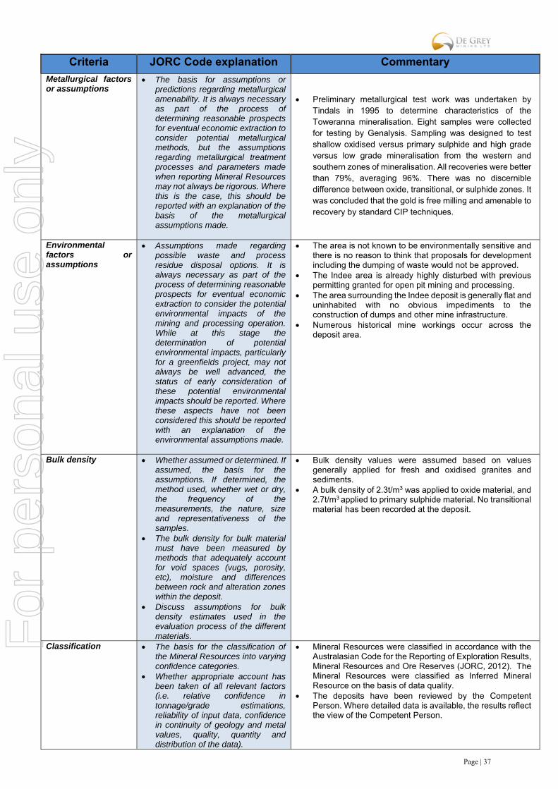
Page | 37
Criteria JORC Code explanation Commentary
Metallurgical factors or assumptions
The basis for assumptions or predictions regarding metallurgical amenability. It is always necessary as part of the process of determining reasonable prospects for eventual economic extraction to consider potential metallurgical methods, but the assumptions regarding metallurgical treatment processes and parameters made when reporting Mineral Resources may not always be rigorous. Where this is the case, this should be reported with an explanation of the basis of the metallurgical assumptions made.
Preliminary metallurgical test work was undertaken by Tindals in 1995 to determine characteristics of the Toweranna mineralisation. Eight samples were collected for testing by Genalysis. Sampling was designed to test shallow oxidised versus primary sulphide and high grade versus low grade mineralisation from the western and southern zones of mineralisation. All recoveries were better than 79%, averaging 96%. There was no discernible difference between oxide, transitional, or sulphide zones. It was concluded that the gold is free milling and amenable to recovery by standard CIP techniques.
Environmental factors or assumptions
Assumptions made regarding possible waste and process residue disposal options. It is always necessary as part of the process of determining reasonable prospects for eventual economic extraction to consider the potential environmental impacts of the mining and processing operation. While at this stage the determination of potential environmental impacts, particularly for a greenfields project, may not always be well advanced, the status of early consideration of these potential environmental impacts should be reported. Where these aspects have not been considered this should be reported with an explanation of the environmental assumptions made.
The area is not known to be environmentally sensitive and there is no reason to think that proposals for development including the dumping of waste would not be approved.
The Indee area is already highly disturbed with previous permitting granted for open pit mining and processing.
The area surrounding the Indee deposit is generally flat and uninhabited with no obvious impediments to the construction of dumps and other mine infrastructure.
Numerous historical mine workings occur across the deposit area.
Bulk density Whether assumed or determined. If assumed, the basis for the assumptions. If determined, the method used, whether wet or dry, the frequency of the measurements, the nature, size and representativeness of the samples.
The bulk density for bulk material must have been measured by methods that adequately account for void spaces (vugs, porosity, etc), moisture and differences between rock and alteration zones within the deposit.
Discuss assumptions for bulk density estimates used in the evaluation process of the different materials.
Bulk density values were assumed based on values generally applied for fresh and oxidised granites and sediments.
A bulk density of 2.3t/m3 was applied to oxide material, and 2.7t/m3 applied to primary sulphide material. No transitional material has been recorded at the deposit.
Classification The basis for the classification of the Mineral Resources into varying confidence categories.
Whether appropriate account has been taken of all relevant factors (i.e. relative confidence in tonnage/grade estimations, reliability of input data, confidence in continuity of geology and metal values, quality, quantity and distribution of the data).
Mineral Resources were classified in accordance with the Australasian Code for the Reporting of Exploration Results, Mineral Resources and Ore Reserves (JORC, 2012). The Mineral Resources were classified as Inferred Mineral Resource on the basis of data quality.
The deposits have been reviewed by the Competent Person. Where detailed data is available, the results reflect the view of the Competent Person.
For
per
sona
l use
onl
y

Page | 38
Criteria JORC Code explanation Commentary
Whether the result appropriately reflects the Competent Person’s view of the deposit.
Audits or reviews The results of any audits or reviews of Mineral Resource estimates.
Internal audits have been completed by PayneGeo which verified the technical inputs, methodology, parameters and results of the estimate.
The review confirmed the suitability of the drilling data for use in Mineral Resource estimates.
Discussion of relative accuracy/ confidence
Where appropriate a statement of the relative accuracy and confidence level in the Mineral Resource estimate using an approach or procedure deemed appropriate by the Competent Person. For example, the application of statistical or geostatistical procedures to quantify the relative accuracy of the resource within stated confidence limits, or, if such an approach is not deemed appropriate, a qualitative discussion of the factors that could affect the relative accuracy and confidence of the estimate.
The statement should specify whether it relates to global or local estimates, and, if local, state the relevant tonnages, which should be relevant to technical and economic evaluation. Documentation should include assumptions made and the procedures used.
These statements of relative accuracy and confidence of the estimate should be compared with production data, where available.
The estimate utilises good estimation practices and good quality historical drilling data. The deposit is considered to have been estimated with a high level of accuracy based on the current interpretation. The majority of lodes have been interpreted with a moderate degree of confidence.
The Mineral Resource statement relates to global estimates of tonnes and grade.
Historical workings occur through the deposit area but no modern mining has taken place.
For
per
sona
l use
onl
y

Page | 39
For
per
sona
l use
onl
y