Embed Size (px)
Citation preview

-. .PipP .,r ,:.>, ;,?-$;, " h t : . . . 'I, ,, ,
,,& .g- ", k! " '* , A $ , ,,y, ; , 5 " * ,
, , , . t . , I
HEAVY-MINERAL TRENDS IN THE BEAUFORT SEA
BY
Gretchen Luepke
Open-file repor t 1975
This report is preliminary and has not been edited or reviewed fo r conformity w i t h Geological Survey standards

HEAVY-MINERAL TRENDS I N THE BEAUFOM SEA
Gretchen Luepke
Abstract
Sediments of t h e ~ e a u f o r t Sea, oFf t h e North Slope o f Alaska
conta in a great v a r i e t y of heavy minerals . These inc lude ga rne t ,
chrome s p i n e l , aug i t e , p igeon i t e , d iops ide , hornblende, e n s t a t i t e ,
hypersthene, epidote, c l i n o z o i s i t e , z o i s i t e , a p a t i t e , tourmaline,
ch lo r i , to id , sphene, z i r con , and opaque minerals . Much r a r e r J
c o n s t i t u e n t s a r e glaucophane, lamproboli te , r u t i l e , kyan i t e , s t a u r o l i t e ,
and r i e b e c k i t e .
.The heavy-mineral f r a c t i o n s t h a t were no t treated with hydrochloric
ac id contain "iron-stained aggregates", g r a i n s of u n i d e n t i f i a b l e
ma te r i a l encrusted with l imonite. Samples containing r e l a t i v e l y high
percentages of i ron-s ta ined aggregates and a l t e r e d opaque minerals
occur i n depths l e s s than 10 m and wi th in 16 km from shore.
Garnet inc reases i n abundance from e a s t t o west., which corresponds
to a s i m i l a r increase i n garnet abundance i n c o a s t a l outcrops of the
Gubik Formation sands. Only ga rne t and i ron-stained aggregates appear
t o have source-related d i s t r i b u t i o n p a t t e r n s . The othex heavy minerals
lack d i s t i n c t d i s t r i b u t i v e provinces, r e f l e c t i n g an environment
dominated by in tense mixing by ice-gougihg and b io tu rba t ion and a
homogenous source a rea , Waves and cur ren t s a r e not s t rong enough t o
s o r t sediments a t depths g r e a t e r than 10 rn except dur ing summer storms.

The source of the Beaufort Sea heavy minerals'is dominated by
contributions from the Alaskan North Slope deposits of Tertiary and
younger age. The Colville,River, largest in the region, is probably
the most influential in transporting sediments, but 'because of wave
and current-mixing of sediments on the shelf, exact contributions
from each river drainage cannot be ascertained. Coastal erosion
of the Gubik Formation is'probably at least as important as the
Colville River in supplying heavy minerals to the Beaufort Sea.
HEAVY-MINl2RAL TRENDS I N THE BEAUFORT'SEA
Introduction
Pu rpse . As part of the environmental-baseline s tud ies of the
offshore North Slope of Alaska, a study w a s made of the heavy minerals
i n the Beaufort Sea t o ascertain the source areas and t ranspor t routes
of sediments on the continental she-lf. '
Set t ing. The Beaufort Sea l i e s north of Alaska from Point B a r r o w
eastward t o the i s lands of the Canadian Arct ic Archipelago ( f i g . 1). 4
The present study area extends from Point Barrow t o Barter Is land,
off the Alaska coast.
Two geomorphic provinces dominate the North Slope of Alaska.
The a r c t i c coasta l p l a in is a gently-sloping surface of low r e l i e f
extending from the coast t o the a r c t i c foo th i l l s . The Gubik
Formation, a dominantly marine. unit of Pleistocene age, blankets the
en t i r e coastal area immediately adjacent t o the ~ e a u f o r t Sea (Payne
and others , 1951). Thickness averages abouepmet res . The Gubik
unconformably over l ies the Sagavanirktok Formation (Early Ter t iary)
and the formations of the Colvi l le and Nanushuk groups (Cretaceous)
(see f ig . 2) .

Pack ice covers t h e shelf f o r n ine months o f t h e yea r ,
e l iminat ing waves and mit iga t ing t h e e f f e c t s of wind-driven c u r r e n t s
and storm t i d e s . During the open-water pe r iod , t h e most common waves
observed have periods of 2 t o 3 seconds and he igh t s o f 20-30 cm.
Surface c u r r e n t s neaxshore a r e wind-driven. Meteorological t i d e s
a r e of l a r g e r amplitude than astronomical t i d e s i n the a r c t i c
c o a s t a l zone (Wiseman, Suhayda and Hsu, 1974, p. 51-59) . - ,
Eighty percent o f t h e North Slope (see f i g . 1) d r a i n s i n t o t h e 4
Beaufort Sea (Walker, 1974, p. 517). The 600-km C o l v i l l e River and
i t s massive t r i b u t a r y system d r a i n seventy-eight percent . Rivers
such as t h e Kuparuk and.Sagavanirktok a r e comparatively s h o r t and
empty i n t o lagoons bounded by offshore b a r s and barrier islands
. . (Walker, 1974, p. 537) .
Barnes and Reimnitz (1974, p. 444) measured c u r r e n t s below t h e
ice cover that show an o v e r a l l westward movement of near-bottom
water on t h e inner she l f a t 2 cm/sec p a r a l l e l t o t h e c o a s t l i n e .
Mountain (1974, p. 27) no tes an eastward flow of su r face water on
the o u t e r s h e l f . Hufford (1974, p. 569) s t a t e s t h a t subsurface
c u r r e n t s appear t o behave independently and o f t e n opposi te of
surface cur ren t s ; 1971 and 1972 measurements showed bottom c u r r e n t s
flowing eastward a t speeds less than 15 m/sec.
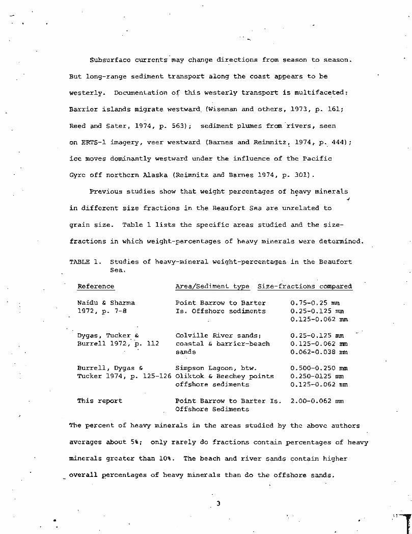
Subsurface cur ren t s may change d i r e c t i o n s from season t o season.
But long-range sediment t r anspor t along t h e coas t appears t o be
westerly. Documentation of this westerly t r anspor t is mult ifaceted:
Barrier i s l a n d s migrate westward. (Wiseman and others , 1973, p. 161;
Reed and S a t e r , 1974, p. 563); sediment plumes from r i v e r s , seen
on ERTS-1 imagery, veer w e s t w a r d (Barnes and Reimnitz, 1974, p.. 444);
ice moves dominantly westward under t h e inf luence of t h e P a c i f i c
Gyre off northern Alaska (Reimnitz and Barnes 1974, p. 301).
Previous s t u d i e s show t h a t weight percentages of hsavy minerals 4
i n d i f f e r e n t s i z e ' f r a c t i o n s i n t h e Beaufort Sea are unre la ted t o
g ra in s i z e . Table 1 lists the s p e c i f i c areas s tud ied and t h e s i ze -
f r a c t i o n s i n which weight-percentages of heavy minerals were determined.
TABLE 1. Studies of heavy-mineral weight-percentages i n t h e Beaufort Sea.
Reference Area/Sediment type Si ,ze-fract ions compared
Naidu & Sharma Point Barrow t o Bar ter 0.75-0.25 mm 1972, p. 7-8 Is. Offshore sediments 0.25-0.12s mm
0.125-0.062 mm
Dygas, Tucker & Colv i l l e River sands; 0.25-0.125 mm Bur re l l 1972, p. 112 coas ta l & barrier-beach 0.125-0.062 mrn
sands 0.062-0.038 mm
Burre l l , Dygas & Simpson Lagoon, btw. 0.500-0.250 nun Tucker 1974, p. 125-126 Oliktok & Beechey p o i n t s - 0.250-0125 nun
offshore sediments 0.125-0.062 m
This repor t Po in t Barrow t o Bar te r Is. 2.00-0.062 nun Offshore Sediments
The percent of heavy minerals i n t h e a reas studied by t h e above authors
averages about 5%; only rarely do f r a c t i o n s contain percentages of heavy
minerals g r e a t e r than 10%. The beach and r i v e r sands conta in higher
overall percentages of heavy minerals than do t h e offshore sands. -

~aidu and Mowatt (1974) discuss relative heavy-mineral weight-
percents in deltaic and shallow-water Beaufort Sea sediments, noting a
more normal grain-size relationship (i.e., higher heavy-mineral percents .
with decreasing grain-size) in the deltaic sediments.
Studies of heavy-mineral distribution patterns have been made in
other shelf seas bordering the Arctic Ocean. Holmes (1967) did not find
enough significant differences in heavy-mineral assemblages of the
Laptev Sea (fig. 1) to attempt any interpretation. General uniformity
of mineral composition in the East Siberian Sea was also noted by Naugler
(1967). However, he found garnet decreases uniformly tyward the center 4
of the study area from the west, and orthopyroxene dominates the eastern
regions. Silverberg (1972) studied heavy-mineral distributions in both
the Laptev and East Siberian seas and identified three heavy-mineral
provinces: clinopyroxene-garnet (west); amphibole-clinopyroxene-epidote
central; and clinopyroxene-epidote-amphibole-opaque minerals (east).
Carsola (1954, p. 1570) examined Beaufort Sea sediment with a bin-
ocular microscope and noted that heavy minerals appeared to constitute a
varied assemblage. The present study, the first to study in detail heavy-
mineral species in Beaufort Sea sediment, confirms this impression.
Methods. Heavy-minerals were separated in tetrabromoethane
(S.G. = 2.96), from microsplits of the sand-size fractions (2.0-0.062 mm)
of 153 samples (Table 2). Three surface samples were taken at the mouth
of the Colville and sagavanirkto, rivers and 20 km upstream in the
Kuparuk River; all other samples were taken in offshore areas (fig. 1).
The weight of the splits ranged from 3.5 to 28.0 grams (average = 14 g).
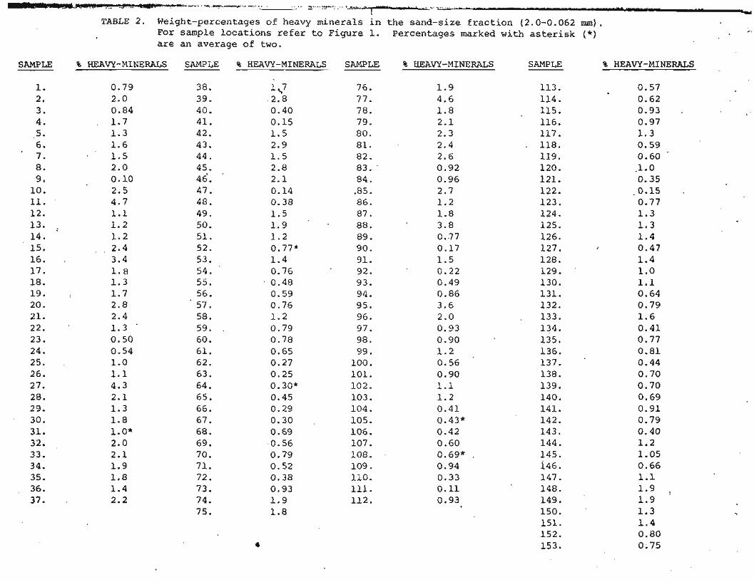
WL)-n Y - * - A . .* - = Y", . I-- - - * TABLE 2. Weight-percentages of heavy minerals i n the sand-size f rac t ion (2.0-0.062 mm).
For sample locations refer t o Figure I. Percentages marked with as te r i sk (*) are an average of t w o .
SAMPLE % HEAW-MINERALS SAMPLE % HEAW-MINERALS SAMPLE % HEAVY-MINERALS SAMPLE % HEAVY-MINERALS

.L
The heavy-mineral concentrates were s ieved and gra ins w e r e mounted
i n Lakeside 70 (n - 1.56). Some of the concentra tes prepared e a r l y i n
t h e s tudy were not mic rosp l i t . Comparisons of s l i d e s prepared with and
without s p l i t t i n g revealed no major d i f fe rences i n mineral frequencies.
Point-counts were made of 42 se lec ted samples (see Table 3; fig. 1 f o r
locat ions) i n t h e 0.25 - 0.062 mm s i z e range; for seven of these
. samples t h e 0.25 - 0,125 mm s i z e range; f o r seven o f - t h e s e samples t h e
0.25 - 0.125 nun s i z e range.was a l s o point-counted, to .determine i f s i ze -
r e l a t e d d i f fe rences i n mineralogy occurred. No s i g n i f i c a n t d i f fe rences
were detec ted . 4
Heavy minerals were i d e n t i f i e d and counted following a l i n e i n
t h e g ra in mount where t h e cross-hai rs touched a g ra in . To he lp insure
a random count, ha l f t h e total number of g r a i n s were counted i n east-west
sweeps, t h e o t h e r h a l f i n north-south sweeps. Care was taken t h a t t h e
two a reas did not overlap.
T h i s method ac tua l ly g ives only number frequency, which gives a sample
b i a s , i n t h a t a l a r g e r g r a i n i s more l i k e l y t o be encountered during t h e
ana lys i s than a smaller one. The discrepancy i s minimized by counting
a l imi ted s i z e range (Galehouse, 1969, p. 814) . Grains were i d e n t i f i e d
as t o mineralogic species when poss ib le . The opaque minerals and
aggregates were separated i n t o iron-stained and unstained groups (see
able 3) . To insure the preservat ion of a p a t i t e , no samples were i n i t i a l l y
t r e a t e d with HC1. Later , mic rosp l i t s of five se lec ted heavy-mineral
- concentrates were heated i n concentrated Hcl over low heat for 30-45 min.
The r e s u l t s were compared with t h e respec t ive nontreated mic rosp l i t s .

Micas and carbonate g r a i n s were noted i n most samples,
p a r t i c u l a r l y t h o s e taken c l o s e t o shore. Because of t h e i r wide
s p e c i f i c - g r a v i t y range (2.7 - 3.1 f o r t h e micas, 2.7-2.9 f o r c a l c i t e
and dolomite; f r o m Allman and Lawrence, 1972, p. 181, Table 28),
t hey are n o t considered t r u e "heavy minera ls" and a r e t h e r e f o r e
omi t ted from t h e point-counting.
Desc r ip t ion of Heavy Minerals
A great v a r i e t y of heavy mine ra l s were i d e n t i f i e d : opaque
minera ls , g a r n e t , chrome s p i n e l , a u g i t e , d i o p s i d e , p i g e o n i t e , 4
hornblende, e n s t a t i t e , hypersthene, @ p i d o t e , c l i n o z o i s i t e , z o i s i t e ,
a p a t i t e , tourmal ine , c h l o r i t o i d , sphene, and z i rcon . Extremely r a r e ,
b u t p o s i t i v e l y i d e n t i f i e d , were glaucophane, lamprobol i te , r u t i l e ,
k y a n i t e , s t a u r o l i t e , and r i e b e c k i t e . One g r a i n of lawsoni te was
seen i n t h e ac id - t r ea t ed m i c r o s p l i t of t h e Kuparuk River heavy-
minera l concent ra te .
Opaque minera ls . Opaque mine ra l s compose an average of 17% of
the heavy mine ra l s counted, w i th extremes a t 6% and 35%. Magnetite
i s p r e s e n t (de t ec t ed wi th a horseshoe magnet) i n v i r t u a l l y all
samples. Where magnet i te w a s n o t d e t e c t e d , t h e p e r c e n t of heavy
minera l s was c o n s i s t e n t l y l e s s t han 1%, and t h e weight of t h e heavy-
minera l f r a c t i o n l e s s t han 0.1 g * The l a c k of magnet i te i n t h e s e
samples is probably a func t ion of e i t h e r the s m a l l heavy-mineral f r a c t i o n
or of s o r t i n g . I lmen i t e i s probably a l s o p r e s e n t , a l though opaque
g r a i n s w i th a w h i t i s h (leucoxene?) a l t e r a t i o n were raxe. P y r i t e
(au th igenic) w a s seen i n the 0.25 - 0.125 nnn f r a c t i o n of sample 70ABP-1.
The forms of t h e opaque g r a i n s ranges from c r y s t a l l i n e t o well-
rounded. Some g r a i n s were su r f i c i a l l y a l t e r e d t o iron-oxide. This
w i l l be discussed l a t e r . '
Treatment i n hydrochloric a c i d did n o t systematicaLly change
the percents of opaque minerals . usual ly the counts remained wi th in
+ 5%, b u t i n one sample t h e percentage decreased 24%; -
Chrome ?pinel , Chrome s p i n e l composes between 1 and 8 pe rcen t
of t h e heavy minerals i n a l l sampJes. This mineral is usua l ly
p a r t i a l l y t r a n s l u c e n t and i s o t r o p i c . The g r a i n s show very high 4
relief and foxms varying from c r y s t a l l i n e t o well-rounded. Concoidal
f r a c t u r e s may be present . Translucent beer-bottle-brown-colored
g r a i n s a r e probably p i c o t i t e (Morris, 1952). Simi la r t r ans lucen t t o
near ly opaque g r a i n s a r e blood-red, an anomalous co lo r fo r p i c o t i t e .
Garnet. Percentages of garnet ranged from 1 t o 11%. Samples
containing g r e a t e r than 5% garne t a l l lay west of Cape Halket t
( f ig . 3 ) . Eas t of Cape Halket t the d i s t r i b u t i o n i s uniformly low.
Color less and pink ga rne t occurs i n a l l samples. The c o l o r l e s s
v a r i e t y genera l ly is more numerous and more etched than t h e pink
va r i e ty . Xn samples taken west of Cape Ha lke t t , garnets with
yellowish hues were seen; t h i s was t h e r a r e s t v a r i e t y noted. A l l
garnets were rounded t o some degree and many contained inc lus ions .
N o sys temat ic attempt was made t o i d e n t i f y t h e s e inc lus ions , although
i n one sample they were c l e a r l y r u t i l e .

Clinopyroxene. As a group, clinopyroxenes c o n s t i t u t e a range
of 11 t o 26% of a l l samples, wi th a maximum of 35%. HC1-treatment,
while no t necessa r i ly rendering spec ies more i d e n t i f i a b l e , inva r i ab ly
increased the percentage of i d e n t i f i a b l e clinopyroxene g r a i n s by a t
least 7% and as much as 18%. The sample from t h e C o l v i l l e River
contained 34% clinopyroxene af ter ac id t rea tment , compared t o 16%
before treatment.
These d i f f e r e n c e s d i d no t a l ter t h e o v e r a l l d i s t r i b u t i o n of
clinopyroxenes. The percentages of t h i s group ranged from 1 t o 16%
within 18 km of t h e coast and from 13 t o 35% beyond 18 km. 4
Augite, diops ide , and p igeon i t e were i d e n t i f i e d , bu t it was
f requent ly impossible t o i d e n t i f y a clinopyroxene a s t o spec ies ,
even where the sample was acid- t rea ted . Because ?f t h i s d i f f i c u l t y ,
the clinopyroxene were grouped together f o r c o r r e l a t i o n purposes.
Augite, t h e most abundant clinopyroxene, had many co lo r s :
green, brown, c o l o r l e s s , occas ional ly purp l i sh . Form ranged from
pr i smat i c t o well-rounded. Saw-toothed e tching of g r a i n s was
occas ional ly noted.
Diopside, t h e most d i f f i c u l t clinopyroxene t o p o s i t i v e l y i d e n t i f y ,
had a very high bi ref r ingence and a c h a r a c t e r i s t i c e x t i n c t i o n angle
(about 3g0) .Where i d e n t i f i e d , d iops ide and p igeon i t e occurred i n
roughly equal amounts, always l e s s than 5% of t h e heavy mineral
f r ac t ion .
Hornblende. Hornblende, with i ts c h a r a c t e r i s t i c e x t i n c t i o n angle
(12 - 30°) and pleochroimt, constitutes 1 to 18% of a l l samples, u s u a l l y
less than 11%. HC1-treatment d id not sys temat ica l ly a l t e r the
percentages o f hornblende i d e n t i f i e d . However, lamproboli te g r a i n s
8

were more likely to be found in acid-treated samples, possibly because I
I
they were masked by limonitic alteration in untreated samples. I I I
Overall hornblende percentages tend to increase with distance from I
shore,
The blue-green and green varieties of hornblende occur in about I equal proportions. The brown varieties, if present, are less abundant
than either green or blue-.green varieties. Lamprobolite (basaltic
hornblende) was seen in 14 samples but it is extremely rare, always I composing less than 1% of the heavy-mineral fraction. It is
4
distinguished from ordinary brown hornblende by its much smaller extinction
0 angle (0-12 ) and red-brown color.
Orthopyroxene. Enstatite and hypersthene rarely exceed 4% of
the heavy-mineral fraction. Enstatite occurs sligktly more frequently
than hypersthene. Enstatite may occur as prismatic or rounded grains; I hypersthene more commonly is prismatic. I
The pleochroism of the hypersthene is in general extremely faint, I indicating that the variety may be ferrohypersthene (Naugler, 1967,
p. 4 2 ) . True hypersthene, with its intense pleochroism, is not as
common as ferrohypersthene in these sediments. In some cases
hypersthene could only be distinguished from enstatite is by its
optic sign.
Epidote groue. In the Beaufort Sea sediments, the epidote groups
constitutes an average of 6% of the heavy-mineral fraction, with
extremes at 2% and 9%. Acid-treatment slightly increased the number
of identifiable epidote grains.

Epidote ( p i s t a c i t e ) i s t h e most common mineral of this group.
It i s o p t i c a l l y negat ive and c h a r a c t e r i s t i c a l l y yellow-green b u t
occas ional ly co lo r l e s s . Epidote aggregates (yellow-green g r a i n s
which do no t go e x t i n c t ) a r e common, sometimes exceeding t he number
of s ing le -c rys ta l g ra ins .
C l inozo i s i t e and z o i s i t e a r e genera l ly less common than epidote ;
together they may equal t h e amount of epidote. z o i s i t e appears t o be
t h e more common of t h e two, though these minerals may be hard t o
d i s t ingu i sh . Both ferrian (normal in te r fe rence co lo r s ) and non-ferr ian 4
(anomalous deep-blue i n t e r f e r e n c e colors) v a r i e t i e s o f z o i s i t e are
present .
Apati te . Apat i te c o n s t i t u t e s about 1% of t h e heavy-mineral
f r a c t i o n of all samples mostly i n small , equidimensional t o e longate ,
rounded gra ins . The mineral occas ional ly occurs i n p r i smat i c g ra ins .
Apat i te was no t seen i n ac id- t rea ted samples.
Apat i te i s a un iax ia l minera l , but sometimes grains may show a
pseudo-biaxial f i g u r e (Milner, 1940, p. 243) . I n t h e Beaufort Sea
sediments, pseudo-biaxial f i g u r e s were seen most commonly i n t h i c k
g r a i n s (b i ref r ingence i n f i r s t - o r d e r yel low). Such g r a i n s can be
confused with z o i s i t e , although t h i s mineral i s o p t i c a l l y p o s i t i v e i n
c o n t r a s t t o a p a t i t e .
T o u r n d i n e . Tourmaline is ubiquitous b u t genera l ly composes
less than 1% of t h e heavy-mineral f r ac t ion . Although an acid- t rea ted
mic rosp l i t f rom the Kuparuk River conta ins 3%, acid-treatment d i d n o t
i n genera l increase the amount of i d e n t i f i a b l e tourmaline.

Both brown and blue-gray varieties of ,tourmaline are present ,
although the brown v a r i e t y is by fa r more common. Grain-form ranges
from pr i smat i c t o well-rounded. Overgrowths a r e rare.
Chlor i to id . Ch lo r i to id usua l ly c o n s t i t u t e s l e s s than 1% of t h e
heavy-mineral f r a c t i o n . The l a r g e s t amount (3%) of c h l o r i t o i d was
seen i n t h e acid-treated sample f r o m the Kuparuk River. It occurs
as smal l , platy gra ins .
Sphene. Except fo r one sample containing 2% sphene, this mine ra l
inva r i ab ly makes up l e s s than 1% of the heavy-mineral fraction. Th,e
g r a i n s a r e c o l o r l e s s t o yellow-brown and rounded.
Zircon. Zircon, though r a r e , i s p resen t i n nearly a l l samples.
s e v e r a l v a r i e t i e s were seen: euhedral , colorZess, unzoned c r y s t a l s ;
c o l o r l e s s t o s l i g h t l y yellow, rounded, ovoid g ra ins ; p ink i sh , zoned
c r y s t a l s .
Some g r a i n s i d e n t i f i e d as z i rcon showed very small e x t i n c t i o n
angles. The i n t e r f e r e n c e figures of such grains appeared t o be
uniaxial p o s i t i v e b u t could a l s o have been b i w i a l p o s i t i v e with a
low 2V. It i s the re fo re possible t h a t such g r a i n s a r e monazite, a
mineral difficult t o d i s t i n g u i s h f r o m zircon.

Other minerals . Glaucophane, kyani te , s t a u r o l i t e , r i e b e c k i t e ,
and lawsonite occurred t o o sporad ica l ly t o be s i g n i f i c a n t . ' Glaucophane, .
however, was i d e n t i f i e d c o n s i s t e n t l y i n samples from t h e C o l v i l l e
River and i ts delta. R u t i l e , though extremely r a r e , was i d e n t i f i e d
i n samples near the mouths of t h e Sagavanirktok and Kuparuk r ivers
and in many samples w e s t of the Sagavanirktok.
Aggregates. The term "aggregate" r e f e r s here t o a g r a i n containing
one or more minerals i d e n t i f i a b l e i n var ied degrees. Two categories
of aggregates were point-counted.
J The f i r s t group, c a l l e d here "unstained aggregates", is made up
of g r a i n s cons i s t ing of two o r more minerals (for example, an opaque
mineral and a clinopyroxene) , or an u n i d e n t i f i a b l e g r a i n which did
not go e x t i n c t .
The second category c o n s i s t s of " i ron-s ta ined aggregates". Such
. g r a i n s a r e not minera logica l ly i d e n t i f i a b l e bu t a r e encrusted with a
yellow-orange iron-oxide m a t e r i a l , probably l imonite. Treatment w i t h
HCl does not render these grains i d e n t i f i a b l e , b u t does destxoy the
l imoni te , leaving the grains white.
Both ca tegor ies of aggregates combined genera l ly compose 20 t o
50% but could, i n a f e w samples, c o n s t i t u t e a s much as 71% of the
heavy-mineral f r a c t i o n . Samples containing more than 60% aggregates
occur invar i ab ly within 16 Krn of the coas t . O f t he f i v e acid-
t r e a t e d samples, t he percentages of aggregates remained about t h e
same in two and decreased i n the o the r s .

Discussion
Dis t r ibu t ion . The heavy minerals never composed more than 5%
the sand-size f r a c t i o n ( see Table 2 ) . N o s i g n i f i c a n t r e l a t i o n s h i p
was apparent between pe rcen t of heavy minera ls and e i t h e r mean grain-
size o r depth of sample. The p a t t e r n s of concentra t ion were q u i t e
random, though percentages g r e a t e r than 1% seemed t o l i e i n a b e l t
beyond t h e b a r r i e d islands and geneYaLLy shoreward of t h e s h e l f
break. Percentages are comparable t o those obtained by o t h e r workers
(Bur re l l , Dygas and Tucker, 1974; Dygas, Tucker and B u r r e l l , 1972;
4
Naidu and Mowatt, 1974; Naidu and Sharma, 1972). Of all t h e heavy-
mineral spec ies , only ga rne t and iron-stained aggregates show any
d e f i n i t e d i s t r i b u t i o n p a t t e r n s i n the Beaufort Sea. Both of these
p a t t e r n s may well be source-dependent.
S i x samples of t h e Gubik Formation taken nea r Point B a r r o w
conta in an average of 8.5% garne t , a maximum of 15%. On t h e other hand,
samples of t h e Gubik taken a t six d i f f e r e n t l o c a l i t i e s east of the
C o l v i l l e River , between Simpson ~ a ~ o 6 n and Prudhoe Bay, contain Less
than 1% garnet .
The higher percentages of ga rne t i n marine sediments west of
Cape Halket t ( f i g . 3) would seem t o suggest e i t h e x a westward
d i r e c t i o n f o r sediment t r a n s p o r t o r l i t t l e t r a n s p o r t from t h e source
rocks. Currents e f f e c t i v e l y keep t h e . g a r n e t supplied from t h e Gubik
Formation moving westward.

I n samples containing high percentages of iron-stained aggregates,
the opaque minerals p resen t commonly show iron-oxide a l t e r a t i o n . For
both groups t h e s t a i n i n g ratio, the r a t i o of t h e frequency of i ron-s ta ined
to unstained g r a i n s , was ca lcula ted .
As seen i n Figure 4 b t h e s t a i n i n g r a t i o f o r opaque minera ls i s
genera l ly l e s s than 1.0. Only close to t h e mouths of t h e major r i v e r s
does the r a t i o exceed 2.0. The s t a i n i n g r a t i o s f o r aggregates ( f i g . 4a)
follow a similar pattern. Only one sample a t the mouth of t h e Sagavanirtok
conta ins x e l a t i v e l y few i ron-s ta ined aggregates. This same sample a l s o 4
conta ins few i ron-s ta ined opaques (see a l s o Table 3).
The percentage of i ron-s ta ined g r a i n s (opaque minerals + aggregates)
diminishes r ap id ly with increas ing depth t o about 20 m, beyond which
the percentage remains on t h e o rde r of 19.5%, never exceeding 27% ( f i g . 5 ) .
The prevalence of i ron-stained aggregates a t lesser depths c lose
t o shore probably r e s u l t s from proximity t o source. These aggregates occur
i n the Ple is tocene Gubik Formation, which forms s e a c l i f f k bordering t h e
coas t l ine . The widespread Cretaceous formations of t h e region a r e
commonly oxidized a t t h e su r face (David M. Hopkins, oral commun., 1975).
The low ~Linopyroxene percentages wi th in 18 km of t h e coas t are probably
an a r t i f a c t r e s u l t i n g from extens iveei ron-s ta in ing of g r a i n s i n samples
from t h i s area.

Table 4 . Minerals of t h e Beaufort Sea grouped as to average ,
specific gravity.
Avg. S.G. = 3.0 - 3.49 Apatite Aug i t e Clinozoisite Diopside Enstatite
. Epidote Glaucophane Hyper s thene Lamprobolite Lawsonite Pigeonite Riebeckite Tourmaline Zoisi te
Avg. S.G . = 3.5 - 4.49
Avg. S.G. = 4.5 - 5.5
Chloritoid Chrome spinel Garnet Hornblende Kyanite Limonite Rutile Sphene Staurolite
Opaque minerals Zircon
D a t a from A l l m a n and Lawrence 1972, Table 28, p. 181, supplemented where necessary with data f r o m Milner , 1940.

Closely associa ted samples, p a r t i c u l a r l y in ' shal low water , tend
t o show d i s t i n c t i v e d i f f e r e n c e s i n mineralogy; percentages o f opaque
minera ls , f o r example, may d i f f e r by 10-15%. To examine p o s s i b l e
reasons f o r these d i f f e r e n c e s , a l l i d e n t i f i e d minera ls were divided
i n t o t h r e e spec i f i c -g rav i ty groups (Table 4 ) . The percent of minera ls
i n t h e "low" speci f ic-gkavi ty range (3.0-3.49) i s dominated by t h e
amount of pyroxene; t h e "medium" range (3.5-4.5) by i ron-s ta ined
aggregates (Limonite S.G. = 3.6-4.0); and t h e "high" range ( g r e a t e r
than 4.5) by opaque minerals . Because t h e d i s t r i b u t i o n of i ron-stained J
aggregates appears t o be con t ro l l ed by proximity t o t h e shore l ine , t h e
r a t i o of minerals i n t h e high range t o t h a t of t h e l o w range was used.
T h i s quan t i ty is defined as t h e dens i ty r a t i o .
% minerals of S . G . 7 4 . 5 Density Ratio (D .R. ) =
% minerals of S . G . = 3 . 0 - 3 . 4 9
Density r a t i o s f o r 32 samples were p l o t t e d aga ins t depth (fig. 6 ) .
I n depths g r e a t e r than 20 m , D.R. never exceeds 1.1. I n water shallower
than 20 m, severa l samples have D.R. g r e a t e r than 1.1, and two near t h e
mouth of t h e Sagavanirktok exceed 1.8. Although some samples from
water d e p t h s l e s s than 20 m have low dens i ty r a t i o s , t h e h ighes t va lues
occur only i n shallow water.

Although the number of samples from this study with very high
density ratios is too small to be statistically significant, it is
interesting to speculate on the origin of the apparent decrease ,in
density-ratio range with depth where source is not a factor. A wide range
of density ratios in closely-spaced samples suggests hydraulic sorting.
A narrow range of density ratios would suggest mixing,
Hydraulic sorting. Waves in the Beaufort Sea normally range
from 2 to 3-second periods and 20 to 30 cm height. A storm of Pingok
Island (see fig. 1) in 1972 produced swells of 9 to 10-second periods 4
and 1.5 to 2.5 m height. The storm lasted several days and produced
longshore currents with velocities as much as 50 cm/sec. (Wiseman,
Syhayda and Hsu, 1974, p. 51).
Threshold orbital velocities (u ) which would act to sort sediments m
may be calculated for the typical and extreme wave regimes noted above
from the equations of Komar and Miller (1974).
Table 5 shows u as calculated for waves of given period (T) height m
(H) , and water depth (h) .
TABLE: 5. ~e~resentative threshold orbital velocities for specific waves.
T, sec. H, h, m u , cm/sec sed.yrain-size moved m

Table 6 . Non-opaque minerals and formations of Alaska North Slope +
where identified (Brosge, Whittington and Morris, 1966; + 1 Keller, Morris and DeHeman, 1961; Morris, 1952; Patton
I and Tailleur, 1964, Payne and others, 1951; and this paper)
Garnet
Chrome spinel
Augite
Hornblende
Epidote
Zoisite
Clinozoisite
ourm ma line
Apatite
Glaucophane
Hypersthene
Chloritoid
Zircon
Rutile
Sphene
Kyanite .
Staurolite
X X X
X X
X X X X X X X X X X X x
X X X X X X X X
X X X X X X X X
X X
1) blue-green 4) clear prisms 2) green 5) ovoid 3) zoned 6) seen only in Sentinel Hill Member

- A certain threshold o r b i t a l v e l o c i t y is required t o i n i t i a t e
t r a n s p o r t o f a given sediment-grain-size. Thus a'wave of T-10 s e c and
u - 20 m / s e c w i l l move 0-20 mm (medium-grained) sand a t depths of max
50 m. But a wave of T=3 s e c and u = 9.8 cm/sec w i l l n o t move 0.125 mm max -
(fine-grained) sand a t a depth of 4 m (Komar and M i l l e r , 1974, p. 772,
f ig . 7 ) .
Therefore, during t h e three-month summer period o f normal waves
i n t h e Beaufort Sea, sands are influenced by waves only i n t h e shal lowest
depths, probably l e s s than 5 m , and wave-generated c u r r e n t s are no t l i k e l y
t o be s i g n i f i c a n t f o r so r t ing . Waves from storm such as t h a t observed 4
i n 1972 would be s t rong enough t o s o r t sediments over most of t h e s h e l f .
Xn winter , waves a r e unimportant, due t o ice-cover.
A t shallow depths o f f r i v e r mouths, t h e bottom i s do t t ed wi th
s t r u d e l scours (Reimnitz, Rodeick and Wolf, 1974, p. 418, f i g . l l) ,
depressions caused by water pouring through d r a i n holes i n t h e ice cover
during the sp r ing ice-breakup (~eimnitz and Bruder, 1972, p. 1 6 2 ) . These
depressions could serve a s concentrat ing a r e a s f o r heavy minerals . The
scouring process i t s e l f is p o t e n t i a l l y a s o r t i n g mechanism. For g r a i n s
of a given s i z e , t h e minerals with higher s p e c i f i c g r a v i t i e s a r e more l i k e l y
t o r e s i s t f u r t h e r t r a n s p o r t once deposi ted, e s p e c i a l l y i n a depression
(Brady and Jobson, 1973, p. 26) . I n depths g r e a t e r than 15 m, ice-gouging of t h e sea f loor i s most
pronounced i n winter (Barnes and ~ e i m n i ' t z , 1974, p. 464, f i g . 19) i n winter .
Sediments within areas of s t rong ice-gouging a r e probably deeply d is turbed.
Thicknesses of Recent sediments are 5 m o r l e s s , wel l wi th in t h e range of
t h e deepes t modern gouges (Reimnitz and Barnes, 1974, p. 302). I n
heavily-gouged areas, o l d e r ma te r i a l may be mixed i n with su r face sediments
(~eimnitz and Barnes, 1974, p. 346) . . .
17

Both b i o t u r b a t i o n and ice-gouging are undoubtedly a t work i n
I wa t e r s deeper t han 15 m. During summer, t h e p o t e n t i a l f o r ice-gouging
i s p r e s e n t i n shal low water b u t dec reases w i th i n c r e a s i n g dep th because
o f fewer ice keels with drafts s u f f i c i e n t t o reach t h e bottom (Barnes
and Reimnitz, 1974, p. 463) . Seasonal e f f e c t s of b i o t u r b a t i o n are
unknown a t p re sen t . The random p a t t e r n o f minera l d i s t r i b u t i o n r e f l e c t s
t h i s mixing process.
Source a rea . A s e r i e s of s ix samples from t h e Meade Uni t o f the
Gubik Formation were c o l l e c t e d from t h e 2 . 5 m i n t e r v a l of an ice c e l l a r
a t 9 m depth , a t t h e Naval A r c t i c Research Laboratory ngar P o i n t Barrow. 4
Most of t h e mine ra l s i d e n t i f i e d i n t h e Beaufort sediments , i nc lud ing
i ron - s t a ined aggrega tes , are represented i n t h e Meade Unit samples.
The Gubik Formation c h a r a c t e r i s t i c a l l y con ta ins rounded g r a i n s (Morris ,
1952) . The Meade Unit however, a l s o con ta ins many p r i s m a t i c g r a i n s ;
hypersthene i s almost exLucsively p r i sma t i c . Beaufort Sea sediments
con ta in both rounded and p r i s m a t i c g r a i n s .
Kyanite has been i d e n t i f i e d i n t h e Sagavanirktok Formation (Payne
and o t h e r s , 1951). Sphene i s p r e s e n t i n t r a c e amounts i n t h e Okpikruak
Formation (KelLer, Morris and Dettennan, 1961), a s w e l l as t he Gubik
Formation Meade Unit ( t h i s pape r ) . S t a u r o l i t e w a s t e n t a t i v e l y i d e n t i f i e d
by K e l l e r i n the K i l l i k - I t i l l i k r eg ion ( T a i l l e u r , o r a l commun., 1975).
The minera l i d e n t i f i e d i n e a r l i e r works by Morris as a n d a l u s i t e was
found t o be a p a t i t e (Patton and T a i l l e u r 1964, p. 72) . The p r e s e n t s tudy
confirms t h i s i d e n t i f i c a t i o n .

A summary table (Table 6) Lists non-opaque minerals identified
in the Beaufort Sea and the formation onshore in which they have been
found. Minerals not previously identified in either the Beaufort Sea
sediments on the Alaska North Slope are diopside, pigeonite, enstatite,
lamprobolite, riebeckite, and lawsonite. These minerals are, however,
sufficiently uncommon that they were probably not encountered at the
time .
Because there are no distinctive exotic heavy minerals described
in the Beaufort Sea sediments, ice-rafting does not appear to be sig- J
nif icant .
Sediment is probably shed directly from the coastal cliffs as
well as transported as bed-load by major rivers and small, local
streams. Also, much of the sediment may be relict.
It seems reasonable to say that the source of the Beaufort Sea
sediments is the Alaskan North Slope and dominantly the Gubik Formation.
Because of the extensive mixing of the sediment and lack of distinctive
mineral assemblages, the contribution of each major drainage to the
~eaufort Sea is masked.
Conclusions
In sediments of the ~eaufort Sea, heavy minerals never composed
over'5% of the sand-size fraction. Twenty-four heavy-mineral species
have been identified. This great variety attests to the rnineralogic
immaturity of the sediments and to the heterogeneity of the source area.

Except f o r ga rne t and i ron-s ta ined aggregates , the heavy minera ls
lack d i s t i n c t d i s t r i b u t i o n provinces. The iron-stained aggregates occur
i n h ighes t percentages i n samples wi th in 16 km of shore. They are probably
derived from t h e sea c l i f f s bordering the Beaufort. The garnet occurs
i n g r e a t e s t amounts w e s t of Cape H a l k e t t , r e f l e c t i n g a higher percent
of garnet i n t h e Gubik formation west of the Colv i l l e .R ive r compared
t o east of the r iver . Higher percentages of ga rne t may also be a
r e f l e c t i o n of the dominant westward t r a n s p o r t of sediments in t h e area.
Waves and cur ren t s i n t he Beaufort Sea are no t s t rong enough t o J
s o r t sands a t depths g r e a t e r than 5 m except during swmner storms.
Therefore, t h e o v e r a l l uniformity of heavy-mineral d i s t r i b u t i o n suggests
an environment dominated by mixing processes. Bioturbation and i ce -
gouging a r e bel ieved t o be t h e most s i g n i f i c a n t . Sor t ing processes
seem t o occur only i n depths of 1-15 m. St rude l scours may serve a s
concentrat ion areas f o r heavy minerals .

ACKNOWLEDGMENTS
Peter' W. Barnes and H. Edward lifto on reviewed t h e manuscript and
offered many h e l p f u l d iscuss ions and encouragement throughout t h i s
project. Glor ia Harris made a number of heavy-mineral grain-mounts.
C. W. Gustafson co l l ec ted the samples from the Meade Unit of t h e Gubik
Fdrmation, and L. David Car ter provided Gubik Formation samples from
l o c a l i t i e s between Simpson Lagoon and Prudhoe Bay. Norma Jeanne Jackson
d r a f t e d t h e i l l u s t r a t i o n s used i n this r epor t .
Robert H. Morris, U.S. ~ e o l o g i c a l Survey, Denver, c l a r i f i e d ques t ions
4 concerning t h e i d e n t i f i c a t i o n of the mineral p i c o t i t e . Irwin T a i l l e u r
provided he lp fu l d iscuss ions about t h e onshore geology of ~ l a s k a ' s North
Slope.

REFERENCES CITED
Allman, Michael and Lawrence, D. F., 1972, Geological Laboratory techniques: Arco Publ. Co., Jnc. , New York, 335 p.
Mnborg, Lennar t , Walker, H. J . , a n d ' ~ e i p p o , Johan, 1967, Suspended load i n t h e C o l v i l l e River, Alaska, 1962: Geograf iska Annaler, v. 49, series A . , p. 131-144.
Barnes, P. W . , 1974, Pre l iminary r e s u l t s of marine geo log ic s t u d i e s o f f t h e no r the rn c o a s t o f Alaska; p. 184-227, In: An e c o l o g i c a l survey of t h e Beaufor t Sea, U .S . Coast Guard Oceano. Rept. CG 373-64.
Barnes, P. W . , and Reimnitz, Erk , 1974, Sedimentary p roces ses on A r c t i c she lves o f f the no r the rn c o a s t of Alaska, p. 439-476 (with d i s c u s s i o n ) , In : The c o a s t and s h e l f of t h e Beaufor t Sea , J. C. Reed and J. ~ r s a t e r , eds . , A r c t i c I n s t . North America.
Barnes, P. W . , Reimnitz, Erk, Gustafson, C. W . , and Larsen, B. R.: 1973, U.S.G.S. marine geologic s t u d i e s i n t h e Beaufor t Sea o f f nor thern A l a s k a , 1970-1972, l o c a t i o n and type of d a t a : U.S .G.S . Open f i l e r e p t . 561, 11. p.
Brady, L. L. and Jobson, H. E . , 1973, An exper imenta l s tudy of heavy- minera l s eg rega t ions under a l l uv ia l - f low cond i t i ons : U . S . Geol. Survey 562-K. 38 p.
Brosge, W. P . , Whi t t ing ton , C. L. and Morris , R. H . , 1966, Geology of t h e Urniat-Maybe Creek r eg ion , Alaska: U.S. Geological Survey Prof . Paper 303-HI p. 501-638.
B u r r e l l , D. C . , Dygas, J. A*, and Tucker, R. W . , 1974, Beach morphology and sedimentolGgy of Simpson Lagoon, p. 45-143, - I n : Environmental s t u d i e s of an a r c t i c e s t u a r i n e sys tem-f ina l r e p o r t , V. Alexander and o t h e r s , Univ. of Alaska I n s t i t u t e Marine Sci. Report 74-1 (Sea Grant Rept. 73-16) .
Carsola, A. J . , 1954, Recent marine sediments from Alaska and Northwest Canadian Arc t i c : Amer. Assoc. Petroleum Geologis t s Bul l . , v. 38, n. 7 , p. 1552-1586.
ChBpman, R. M., and Sable , E. G . , 1960, Geology of t h e Utukok-Corwin r eg ion , northwestern Alaska: U.S. Geol. Survey P ro f . Paper 303-C, p. 47-167.
Collins, F. R. and Bergquis t , H . R . , 1958a, T e s t w e l l s , Topagoruk area, Alaska: U.S. Geol. Survey Prof. Paper 305-D, p. 265-316.
C ~ l l i n s , F. R. , and Bergquis t , H. R. , 1958b, T e s t w e l l s , Meade and Kaolak a r e a s , Alaska: U. S . GeoL. Survey p ro f . 'Paper 305-F I
p. 341-376.
C o l l i n s , F. R., and Bergquis t , H. R. , 1959, Test w e l l s , Square Lake and Wolf Creek a r e a s , Alaska: U.S. Geol. survey P ro f . Paper 305-H, p. 423-484.
C o l l i n s , F. R. , and Brewer, M. C . , 1961, Core t e s t s and t e s t w e l l s , Barxow a r e a , Alaska: U . S . Geol. Survey P ro f . Paper 305-K, p. 569-644.
C o l l i n s , F. R . , and Brewer, M. C . , 1964, Core t e s t s , Simpson area, Alaska: U . S . Geol. Survey Prof. Paper 305-L, p. 645-730.
C o l l i n s , F. R. , and o t h e r s , 1958, Tests w e l l s , Umiat area, Alaska: U.S . Geol. Survey P ro f . Paper 305-8, p. 71-206. ,
Dygas, J. A. , Tucker, Robert , and B u r r e l l , D. C . , 1972, Geologic r e p o r t o f t h e heavy minera ls , sediment t r a n s p o r t and s h o r e l i n e changes of t h e barrier i s l a n d s and c o a s t between Ol ik tok P o i n t and Beechey P o i n t , p. 61-121: In : Kinney, P. J. and o t h e r s , '
Basel ine d a t a s tudy of t h e Maskan A r c t i c a c q u a t i c environment, Univ. Alaska I n s t . Marine S c i . Rept. R72-3.
Galehouse, J. S. , 1969, Counting g r a i n mounts - number percentage vs. number frequency: Jour . Sed. ~ e t r o l o ~ ~ , v. 39, n . 2 , p. 812-815.
G X Y C , George and others, 1956, Mesozoic sequence i n C o l v i l l e River r eg ion , no r the rn Alaska: Amer. Assoc. Petroleum Geolog i s t s B u l l . , v. 40, no. 2 , p. 209-254.
Holmes, M. L., 1967, La te P l e i s t o c e n e and Holocene h i s t o r y of t h e Laptev Sea: Unpubl. M. S. t he s i s , Univ. of Washington, 99 p.
Hufford, G. L., 1974, Dissolved oxygen and n u t r i e n t s a long the North Alaskan s h e l f , pp. 567-588 (with d i s c u s s i o n ) , In: The coast .and s h e l f o f t h e Beaufort Sea, J. C. Reed, and J. E. S a t e r , eds . , A r c t i c I n s t i t u t e of North America.
K e l l e r , A. S . , orris, R. H . , and Detterman, R. L . , 1961, Geology of t h e Shaviovik and Sagavanirktok ~ i v e r s r eg ion , Alaska: U.S. Geol. Survey P ro f . Paper 303-Dl p. 169-222.
Komar, P. D. , and M i l l e r , M. C . , 1974, Sediment t h re sho ld under o s c i l l a t o r y waves: 14 th Con£. Coastal Enginnering Proc . , Amer. Sac. C i v i l Engineers , p. 756-775.

Milner , H . B., 1940, Sedimentary petrography, 3 r d . e d . : Thomas Murby and Co., London, 666 p.
Mountain, D. G . , 1974, Pre l iminary a n a l y s i s of Beaufor t Sea shelf c i r c u l a t i o n i n summer, p. 27-42, - I n : The c o a s t and s h e l f of the Beaufort Sea , J. C. Reef, and J. E. S a t e r , eds., A r c t i c I n s t . North America.
Morris, R. H . , 1952, Heavy mineral a n a l y s i s of sedimentary rocks of no r the rn Alaska: U.S. Geol. survey Open-File Rept. 68 p.
Naidu, A. S . , and Mowatt, T. C . , 1974, Aspects o f s ize d i s t r i b u t i o n , mineralogy and geochemistry of d e l t a i c and a n c i e n t sha l low marine sediments , North Arctic Alaska: Univ. Alaska I n s t . Marine Science Rept. 74-1, p. 145-207. ( a l s o p. 238-268, I n : A n e c o l o g i c a l survey of the Beaufort Sea , U.S. Coast ~ u ~ d Oceano. R e p t . CG 373-64.
3
Naidu, A. S . , and Sharma, G. D . , 1972, Texture, mineralogy, and chemistry of A r c t i c Ocean sediments: I n s t . Marine Sc ience , Univ. of Alaska, Rept. R72-12, 31 p.
Nauglex, F. P . , 1967, Recent sediments of t h e E a s t S i b e r i a n Sea: Unpubl. M . S . t h e s i s , Univ. of Washington, 7 1 p.
Pa t ton , W. W . , Jr . , and T a i l l e u r , I. L., 1964, Geology of t h e K i l l i k - I t k i l l i k r eg ion , Alaska: U . S . Geol. Survey P ro f . Paper 3 0 3 - G , p. 409-500.
Payne, T. G . , and o t h e r s , 1952, Geology of t h e A r c t i c s l o p e of Alaska: U.S. Geol. Survey O i l and Gas Inves t . Map OM-126, 3 ' s h e e t s .
Reed, J. C. , and S a t e r , J. E. , eds . , 1974, The coas-t and s h e l f o f t h e Beaufort Sea: Arctic I n s t i t u t e of North America, Ar l ing ton , V i r g i n i a , 750 p.
R e h n i t z , Erk and Barnes, P. W . , 1974, Sea i c e a s a geologic agent on t h e Beaufort Sea s h e l f of Alaska, p. 301-353 (with d i s c u s s i o n ) , I n : The c o a s t and s h e l f o f t h e . B e a u f o r t Sea, J. C. Reed and - J. E. S a t e r eds., A r c t i c I n s t . North America.
Reimnitz, Erk and B r u d e r , K. F., 1972, River d i scha rge i n t o an i ce - covered ocean and r e l a t e d sediment d i s p e r s a l , B e a u f o r t Sea, coast of Alaska: Geol. Soc. America B u l l . , v. 8 3 , no. 3, p. 861-866.
Reimnitz, E r k , Rodeick, C. A, , and Wolf, S. C., 1974, S t r u d e l scour - a unique A r c t i c marine geologic phenomenon: Your. Sed. Pe t ro logy , v., 44, no. 2 , p. 409-420.
Robinson, F. M., 1956, Core t e s t s and t e s t w e l l s , Ournalik area, Alaska: U.S. Geol. Survey Prof. Paper 305-A, p. 1-70.
Robinson, F. M,, l958a, Test w e l l s , Gubik a r e a , Alaska: U.S. Geol. Survey Prof . Paper 305-C, p. 207-264.
Robinson, F. M . , 1958b, Tes t w e l l s , Grandstand area, Alaska: U.S. G e o l . Survey Prof. Paper 305-E, p. 317-339.
Robinson, I?. M . , and ~ e r g q u i s t , H. R., 1959, T e s t w e l l s , T i t a l u k and Knifeblade a r e a s , Alaska: U.S. Geol. Survey Prof. Paper 305-GI p. 377-422.
Robinson, F. M . , and C o l l i n s , F. R., 1959, Core test, S e n t i n e l H i l l a r e a and test w e l l , F i s h Creek area, Alaska: U . S . Geol. Survey Prof. Paper 305-1, p. 485-521.
4
Robinson, F. M . , and Yuster , S . T . , 1959, T e s t w e l l s , Simpson area, Alaska: U . S . Geol. Survey P r o f . Paper 305-J, p. 523-568.
Silverberg, Norman, 1972, Sedimentology of t h e surface sediment of the E a s t S i b e r i a n and Laptev Seas: Unpubl. Ph.D. t h e s i s , Universi ty o f Washington, 134 p.
Walker, H . J., 1974, The C o l v i l l e River and t h e Beaufor t Sea-some i n t e r a c t i o n s , p. 513-540 ( w i t h discussion), In: The coast and s h e l f o f t h e Beaufort Sea, J. C. Reed and J. E. S a t e r , e d s . , Arctic Inst. of North America.
Wiseman, W. J . , Jr., Suhayda, J. N . , and H S U , S. A . , 1974, C h a r a c t e r i s t i c s of nearshore oceanographic environment of arctic Alaska, p. 49-64, In: The coast and shelf of t h e Beaufor t Sea, J. C. Reed and J. E. - S a t e r , eds., Arctic I n s t . of North America.
Wiseman, W. J., Jr., and o t h e r s , 1973, Alaska Arctic c o a s t a l p roces ses and morphology: Louisiana S t a t e Univer. Coas t a l S t u d i e s I n s t . Tech. R e p t . 149. 171 p.

~ i s t of Figures
Figure 1. Index map showing study area i n the Beaufort Sea.
Figure 2. ~eneralized stratigraphic column of Cenozoic and Mesozoic r o c k s of Alaska's North Slope (Colville River region).
Figure 3. Distribution of garnet i n the Beaufort Sea.
Figure 4a. S t a i n i n g rat ios for aggregates i n the Beaufort Sea.
Figure 4b. Staining r a t io s for opaque minerals in the Beaufort Sea.
Figure 5 . elations ship of percent of iron stained g r a i n s ( aggrega t e s of opaque minerals) t o sample depth.
Figure 6. elations ship o f density r a t i o t o sample de6th. 4

Figuxe 2. Generalized stratigraphic column of Cenozoic and Mesozoic rocks of Alaska's North Mlope (Colville River region). (After Gryc and others, 1956, p. 212, fig. 2).
b
2 2 W I3 Id 3
-
Gubik Formation
2 4 H
E W B
Sagavanirktok Formation
IC1
5
0
W
U
R
E-1
W
p:
u,
north -> lu ,-I 4 -4 3 $ 0 4 Ll O W 0
a 3 0 &4 a
3 5 2 rg Z
Okpikruak Formation
U
undifferentiated L. Cxetaceous (? ) &
U. Jurassic (?) rocks
Prince Creek Schrader Bluff Formation Formation
/ -
Seabee Formation
-
Ninuluk Fdrmation C
Chandler Formation
'L
Grandstand Formation
a ?I rl *d $ 0
r-4 b 0 r.3 v
$, k c-9
s 5 3 E: m 2;
Torok Formation
W m
1 R, E tn 2 H a: t3
- Oumalik Formation
-
Tuktu Formation -.. -
- Tiglukpuk Formation ? ? ?-
absent
Topagoruk Formation
Kingak Formation
Shublik Formation

Heavy-Mineral Trends in the Beaufort Sea -- Gretchen Luepke
Errata
Table 4 - Hornblende should be l i s t e d under -- average S.G. = 3.0-3.49
p. 15 - last paragraph should read as follows :
Density ratios for 26 samples were plotted a g a i n s t depth ( f ig . 6) In depths greater than 2 0 m, D,R. values exceed 0.8 only once and never exceed 0.9. In water shallower than 20 rn, n ine samples h a w D.R. greater than 0.8, and f x o near the m o ~ t h of the Sagavanirktok exceed 1.7 . Al.-E;11ough some samples from water depths less t h an 20 m have l o w d e n s i t y - r a t i o values, t h c I ~ i g h e s t values occur only in shallow water. I n other words, t h e greatest range of d e n s i t y - r a t i o values is seen An samples. from water depths less than 20 m.