Embed Size (px)
Citation preview
May 2010
ArchaeologicalEvaluation Report
Arc
ha
eo
log
ica
l Evalu
atio
n Re
po
rt
OA East Report No: 1183
OASIS No: Oxfordar3-76945
NGR: TL 5507 8133
Client: CgMs
Pits and Field Systems on land off Carey Close Ely
Burnt flint pits and probable Iron Age/Roman field systems on land off CareyClose, Ely
Archaeological Evaluation
By Rob Atkins BSocSc
With contributions by Rachel Fosberry HNC Cert Ed AEA and Steven Wadeson
Editor: Aileen Connor BA AIFA
Illustrator: Séverine Bézie BA MA
Report Date: May 2010
© Oxford Archaeology East Page 1 of 25 Report Number 1183
Table of Contents
Summary.........................................................................................................................................7
1 Introduction................................................................................................................................9
1.1 Location and scope of work.........................................................................................9
1.2 Geology and topography.............................................................................................9
1.3 Archaeological and historical background................................................................10
1.4 Acknowledgements....................................................................................................10
2 Aims and Methodology............................................................................................................11
2.1 Aims............................................................................................................................11
2.2 Methodology...............................................................................................................11
3 Results......................................................................................................................................12
3.1 Introduction ...............................................................................................................12
3.2 Trench 1.....................................................................................................................12
3.3 Trench 2 ....................................................................................................................12
3.4 Trench 3.....................................................................................................................12
3.5 Trench 4 ....................................................................................................................12
3.6 Trench 5 ....................................................................................................................13
3.7 Trench 6 ....................................................................................................................13
3.8 Finds Summary..........................................................................................................14
3.9 Environmental Summary...........................................................................................14
4 Discussion and Conclusions.................................................................................................15
4.1 Overview ...................................................................................................................15
4.2 Significance...............................................................................................................16
4.3 Recommendations.....................................................................................................16
Appendix A. Trench Descriptions and Context Inventory.....................................................17
Appendix B. Finds Reports.......................................................................................................19
B.1 Lithics.........................................................................................................................19
B.2 Pottery and roof tile....................................................................................................20
B.3 Fired clay/daub...........................................................................................................20
Appendix C. Environmental Reports........................................................................................20
© Oxford Archaeology East Page 3 of 25 Report Number 1183
C.1 Environmental samples.........................................................................................20
Appendix D. Bibliography .........................................................................................................23
Appendix E. OASIS Report Form .............................................................................................24
© Oxford Archaeology East Page 4 of 25 Report Number 1183
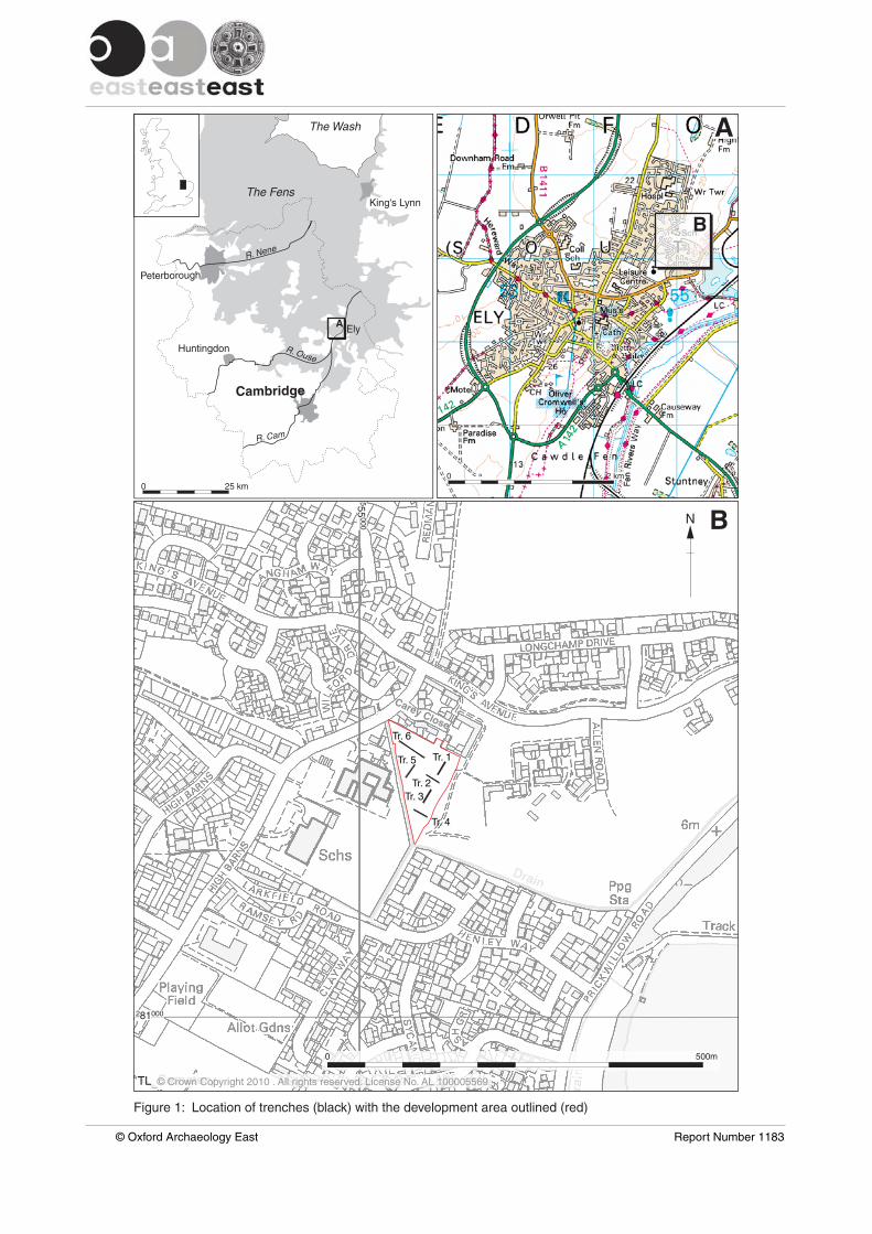
List of FiguresFig. 1 Location of trenches (black) with the development outlined (red)
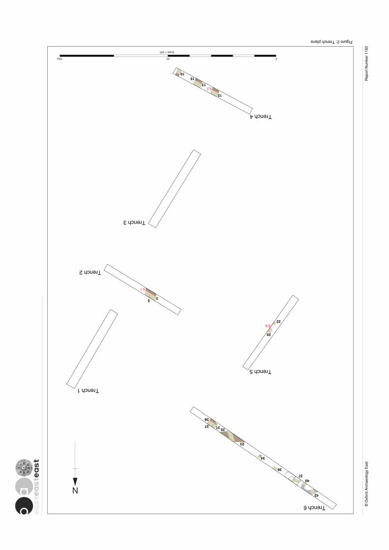
Fig. 2 Trench plans
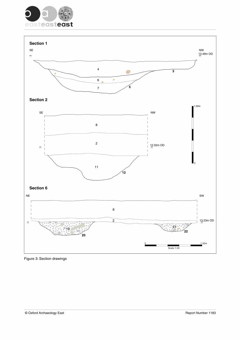
Fig. 3 Section drawings
List of PlatesPlate 1 Trench 5, pits 20 and 22 looking south
List of TablesTable 1 Lithics from pits 20 and 22Table 2 Results from samples
© Oxford Archaeology East Page 5 of 25 Report Number 1183

© Oxford Archaeology East Page 6 of 25 Report Number 1183
Summary
Archaeological evaluation on land off Carey Close, Ely (TL 5507 8133) found sparseshallow ditches probably part of a field system belonging to a Middle Iron Age toLate Roman settlement 100m to the north of the subject site. Only a single Romanpottery sherd was recovered from one of the ditches.
Of particular significance are two pits, c.10m to the east of a stream which flowedalong the western boundary of the site. These pits contained large quantities ofshattered burnt flint and sandstone pieces (16.7kg), fired clay (2.3kg), some ofwhich showed evidence for structure, and 3 debitage flint flakes within their backfill.Their date is unknown but they are likely to be pre-Roman and possibly relate tocooking, a sauna or the production of temper for pottery production.
© Oxford Archaeology East Page 7 of 25 Report Number 1183

© Oxford Archaeology East Page 8 of 25 Report Number 1183
1 INTRODUCTION
1.1 Location and scope of work1.1.1 An archaeological evaluation was conducted by Oxford Archaeology East (OA East) on
0.9 ha of land off Carey Close, Ely (Fig. 1) during May 2010.
1.1.2 This archaeological evaluation was undertaken in accordance with a Specificationprepared by OA East (Atkins 2010). The evaluation was commissioned at pre-planningstage. An application has now been submitted (East Cambridgeshire District Council10/00116/OUM). The proposed development is for 25 houses. The evaluation wasdesigned to assist in defining the character and extent of any archaeological remainswithin the proposed development area, in accordance with the guidelines set out inPlanning Policy Statement 5: Planning for the Historic Environment (Department forCommunities and Local Government 2010).
1.1.3 The site archive is currently held by OA East and will be deposited with the appropriatecounty stores in due course.
1.2 Geology and topography1.2.1 The British Geological Survey (1980) shows the site as lying within an area of drift
geology consisting of Middle Pleistocene glacial tills. The underlying solid geology hereis Lower Greensand and Kimmeridge Clay (British Geological Survey 1980). Trenchingrevealed predominantly weathered glacial tills (comprising stiff mixed grey clay withchalk inclusions) and relict periglacial ground ice features filled with fine yellow/orangesands (observed in Trench 6). In Trench 5 (and close to a stream or drain) a patch ofsmall pebbles and stones was observed overlying the glacial tills. This natural feature islikely to have been formed by clast sorting within the active ground ice layer on agentle south-westerly facing slope. Manganese staining was also observed in this areaand is likely to have formed as a response to the waterlogged conditions existing inthis area.
1.2.2 The site is located on the east side of a meandering stream (marked drain on Figure 1)in a gently sloping valley. The stream has been channelled and straightened to followfield boundaries. The 1886-8 Ordnance Survey 1:2500 map shows that the stream islikely to have risen in the vicinity of New Barns House to the north-west of the site. Itappears to have followed a naturally winding course until reaching the subject sitewhere it has been straightened, and as it leaves the site at the southern end it turnseastwards and then fairly sharply north, after which it enters Waterden Fen and finallyempties into the river Great Ouse.
1.2.3 The stream acts as a boundary along the western edge of the site, at its highest pointas it enters at the north-west corner it is approximately 14.65m, dropping to 12.80m asit leaves in the south-west. From the stream (both in the west and south-east) the landrises gently north and east towards Carey Close (which forms the northern boundary)where it reaches approximately 15.2m and continues to climb northwards until itreaches an area of level ground (at approximately 21.7m) occupied by a Middle IronAge to Late Roman settlement (Atkins and Mudd 2003, 5).
© Oxford Archaeology East Page 9 of 25 Report Number 1183
1.3 Archaeological and historical background1.3.1 The site is located in the High Barns area of Ely, outside the medieval and post-
medieval core. It is very likely that High Barns was enclosed during the reign of HenryVIII and was probably cultivated fields during the medieval period (Palmer 1937). TheCHER (Cambridgeshire Historic Environment Record) lists several sites and find-spotsin the vicinity of the site:
CHER 06136: A Beaker burial and barrow uncovered directly to the north-west of thedevelopment area in 1958 at TL 550 816 (Hall 1996 Ely Site12).
CHER 11967: Archaeological work about 200m to the south-east, initially consisted offive evaluation trenches followed by a 15m by 15m open area excavation (TL 552 811).A scatter of flint which dated to the later Neolithic and Bronze Age and a possibleprehistoric pit were found. Late Iron Age/Early Roman drainage ditches were alsouncovered and these were superseded by a 1st or 2nd century droveway (Whittaker1997; Dickens 1997).
CHER 11906: An archaeological evaluation took place in 1996, 200m to the south-west(TL 549 810;). This consisted of seven evaluation trenches with 10 ditches found onfour different alignments. All were undated except a single ditch possibly dated by oneRoman pottery sherd. There were also some Roman and Saxon pottery sherdsrecovered from the topsoil (Kemp1996).
CHER 10259: An archaeological evaluation 50m to the north-west of the subject site(TL 550 814) found up to seven undated ditches/linear features in 300m of trenching,four Iron Age and one Roman pottery sherds were recovered from the topsoil (Haley1992). None of the ditches are likely to continue into the subject site.
CHER 14805: In 1999 and 2000, an archaeological evaluation and subsequentexcavation took place on land adjacent to the north and east of the subject site (TL 551814). The main archaeological remains were found on higher ground at least 40m tothe north and north-east of the subject site. A background scatter of 97 Neolithic andBronze Age flints was recovered. Later occupation comprised a Middle Iron Age (c.5thto 3rd century BC) to Late Roman (4th century AD) farmstead. Results of a geophysicalsurvey suggested the settlement was located at least 50m to the north of the subjectsite. The excavation supported this interpretation although did reveal a few shallownorth to south aligned Roman ditches, possibly part of a field system (Meadows 1999;Atkins and Mudd 2003). The ditches extended beyond the excavation area southwardstowards the subject site.
1.4 Acknowledgements1.4.1 The author would like to thank CgMs who commissioned the evaluation especially
Michael Dawson. The project was managed by Aileen Connor who also edited thisreport. Dan McConnell of Cambridgeshire County Council visited the site and monitoredthe evaluation on behalf of the planning authority.
1.4.2 I am grateful for specialist analysis from Rachel Fosberry and Steve Wadeson. RichardMortimer kindly commented on the worked flint. Taleyna Fletcher carried out the surveyand the author directed the field work assisted by Chris Faine. Séverine Bézieproduced the illustrations. Steve Critchley offered advice on the local geological historyof the site. Lukas Barnes provided additional assistance as a volunteer.
© Oxford Archaeology East Page 10 of 25 Report Number 1183
2 AIMS AND METHODOLOGY
2.1 Aims2.1.1 The objective of this evaluation was to determine as far as reasonably possible the
presence/absence, location, nature, extent, date, quality, condition and significance ofany surviving archaeological deposits within the development area.
2.2 Methodology2.2.1 The Specification required that the trial trenches will be excavated by machine to the
depth of geological horizons, or to the upper interface of archaeological features ordeposits, whichever is encountered first (Atkins 2010). A JCB type of machineexcavator under archaeological supervision was fitted with a 1.6m wide flat bladedditching bucket which was used to excavate six trenches. The location of the trencheswas agreed with by both Dan McConnell of Cambridgeshire County Council andMichael Dawson of CgMs (Fig. 1). These comprised one 40m trench running east towest to assess whether a series of north-south ditches found during excavation to thenorth continue into the subject site, and five 20m trenches laid out on a standard gridarray and tied into the Ordnance Survey using a Leica 1200 GPS coupled with Leicasmartnet. (Fig. 1).
2.2.2 All archaeological features and deposits were recorded using OA East pro-formas.Trench locations, plans and sections were recorded at appropriate scales (plans at 1:50and sections at either 1:10 or 1:20). Monochrome and digital photographs were takenof all relevant features and deposits, supported by digital photographs. Fourenvironmental samples were collected comprising two 10 litre samples from ditchesand two 30 litre samples from pits.
2.2.3 Conditions in the field were good and other than a high water table at the southern endof the site there were no factors that might adversely affect observation and recording.
© Oxford Archaeology East Page 11 of 25 Report Number 1183
3 RESULTS
3.1 Introduction 3.1.1 The following results are presented by trench in numerical order. A listing of the context
details by trench/context appear in Appendix A. Topsoil (8; 0.30-0.35m thick) andsubsoil (2; 0.05-0.40m thick) were found in every trench except Trench 1 and part ofTrench 6 where topsoil had been removed and replaced with hardcore and tarmac. Alltrenches were 1.80, wide and either 20m or 40m in length.
3.2 Trench 13.2.1 Trench 1 was 20m long and ran roughly north-east to south-west in the north-eastern
corner of the site. The natural was a yellowish grey boulder clay till, no archaeologicalfeatures were present. The subsoil (2) was 0.3m thick and sealed by modern hardcore(1; 0.18m thick).
3.3 Trench 2 3.3.1 Trench 2 was 20m long and ran north-west to south-east in the central eastern part of
the site. In the middle of the trench there were two undated features (Fig. 2)comprising a possible pit or ditch terminus (5) which was overlaid by a later shallowditch which ran roughly north to south (3). Pit/ditch terminus (5) was 1.8m wide, bymore than 0.60m long and 0.42m deep (Fig. 3, S1). It had moderate sides and a basewhich sloped slightly down towards the north. Its basal fill (7) was a dark blueish greysilty clay overlaid by a light brownish grey silty clay (6). It was cut by a ditch (3) whichwas 2.8m wide and 0.3m deep with moderate to steeply sloping sides and a slightlyconcave base. Ditch 3 was backfilled with a single deposit of a mid brownish grey claysilt (4). These features were sealed by subsoil (2). A fragment of medieval roof tile wasfound in the subsoil immediately above ditch 3.
3.4 Trench 33.4.1 Trench 3 was 20.3m long and located directly to the south of Trench 2 on a roughly
north-east to south-west orientation. No archaeological features were present. Thesubsoil layer (2; 0.20m thick) was overlaid by topsoil (0.33-0.35m thick).
3.5 Trench 4 3.5.1 Trench 4 was located in the lowest area of the site just to the east of the stream. It was
aligned south-east to north-west and was 20m long. The water table was very high (c.12.00, OD) in this trench and all of the features filled with water as soon as they wereexcavated. Four probable ditches (12, 13, 15 and 10) were present, all of them paralleland aligned north-east to south-west . (heading towards the stream). Ditch 10 was 1mwide and 0.21m deep with moderately steep sides and a flattish base (Fig. 2). It wasfilled with a mid brownish grey clayey silt (9) from which a single Roman pottery sherdwas recovered. The ditch was sampled (<1>), but no environmental remains werepresent. Ditches 15 and 13 were shallow and undated. The earliest (15) was morethan 0.5m wide and 0.1m deep and filled with a dark greyish brown clay silt (16). Ditch13 was 1.1m wide and 0.18m deep with moderately steep sides and a flat base. It wasfilled with a mid reddish brown clay silt (14). Ditch 12 was more substantial at 1.6mwide and 0.44m deep with a flattish base and moderately steep south side although the
© Oxford Archaeology East Page 12 of 25 Report Number 1183
south-eastern edge was somewhat irregular (Fig. 3, S2). It was backfilled with a darkgrey brown clay sandy silt (11) that contained no finds.
3.5.2 Subsoil (2; 0.40m thick) sealed the ditches, it may be slightly thicker here due toperiodic flooding.
3.6 Trench 5 3.6.1 Trench 5 was 20.3m long, aligned north-east to south-west, near to the stream (Fig. 2).
The natural clay here was overlain be an area of small flint pebbles and stones in thesouthern 8m of the trench nearest the stream. This is likely to be a natural periglacialfeature, rather than archaeological. Manganese staining was also observed in this areaand is likely to have formed as a response to waterlogged conditions. The onlyarchaeological features in this trench were two small pits (20 and 22; Fig. 2, Plate 1),both contained significant quantities of burnt flints and other materials but showed nosigns of in-situ burning. No datable finds were recovered from these pits but thecharacter of their fills (burnt flint and clay) suggests a prehistoric date.
3.6.2 Pit 22 was 0.65m long, more than 0.55m wide and 0.15m deep (Fig. 3, S.6). The pithad moderately steep sides and a slightly rounded base. It was backfilled with burntflint nodules, burnt sandstone (8.649kg) and burnt clay (0.322kg) (Table 1), within amatrix of very dark brown/black slightly clayey sandy silt with frequent charcoal flecks.A small number of unburnt flint pieces including three flakes of debitage were alsofound, none were diagnostic. A soil sample (<3>) from the deposit contained noenvironmental materials of any significance.
3.6.3 Pit 20 was 1.1m long, more than 0.85m wide and between 0.22m and 0.26m deep (Fig.3, S.6). It had moderately steep sides and a flattish base although it was noticeablyslightly deeper near the western side of the pit. It was backfilled with burnt flint (8.01kg)and burnt clay (1.973kg) within a matrix of charcoal flecked very dark brown to blackslightly clayey sandy silt (19). Although no datable finds were recovered from the pit, itdid contain three fragments of burnt clay that were clearly structural; two had imprintsfrom withies and a third piece of smoothed ?lining was impressed with a possiblethumb print. A soil sample (<2>) from the pit contained no environmental materials ofany significance.
3.6.4 The subsoil in this trench was very thin (0.05-0.07m) and was overlain by topsoil (0.3-0.35m thick ).
3.7 Trench 6 3.7.1 Trench 6 was 40m long and was aligned south-east to north-west for 40m. Several
features were present, although all of them were undated. They comprised two ditches(23 and 29), and five possible pits (25, 27, 31, 34 and 36). Two natural features (37 and40/42) (Fig. 2) were also found. Although undated there is evidence for two phases ofactivity; an earlier pitting phase with later ditches.
3.7.2 Pits 27 and 31 were similar in form, they were both sub-circular or oval in shape withthe former at least 0.8m long by more than 0.4m and the latter 0.6m by 0.40m. Theywere both shallow (respectively 0.3m and 0.1m deep) and filled with a sterile darkblueish grey silty clay. They were both cut by a north-east to south-west aligned ditch(29). Pit 25 was more than 2m long, 0.80m wide and 0.17m deep. It was filled with asterile mid greyish brown sandy clay and was cut by ditch 23. Pit 34 was sub-circular,0.65m by 0.55m and 0.24m deep with steep sides and a flattish base which was slightlydeeper on the northern side. It was backfilled with a mid grey brown clay sandy silt with
© Oxford Archaeology East Page 13 of 25 Report Number 1183
occasional stones. These mostly comprised natural flint pieces up to 0.15m in lengthand 0.03m thick. Less than four metres to the west of pit 34 was another pit (36) whichwas partly within the northern baulk of the trench. It was 1.15m long, more than 0.7mwide and 0.14m deep with gentle sides and a flattish base. Pit 36 was filled with a lightto medium brown sandy silt and some clay. None of the pits contained datable finds.
3.7.3 The two ditches were on different alignments and are therefore likely to representdifferent phases. Ditch 29 was 1.2m wide and 0.2m deep and filled with a dark blueishbrown silty clay, it was aligned north-east to south-west. Ditch 23 was aligned east towest, it was 1m wide and 0.16m deep and filled with a mid blueish brown silty clay.Neither contained any datable finds and the soil sample (<4>) from ditch 29 wascompletely sterile.
3.7.4 Two natural features (37 and 40/42; Fig. 2) were recorded in this trench. Feature 37had irregular edges and was filled with a clean sterile light blue silty clay, possibly as aresult of ice cracking. A similar feature was located adjacent to the east. Feature40/42 was roughly crescent shaped, 3.8m by more than 1.6m across with severelyundercutting sides. It was backfilled with a mid greyish brown clayey sand and a lightto mid brown sandy silt with a little clay. The classic crescent shape suggests that thiswas a tree throw (the result of a tree falling over and its roots dragging up theunderlying soil).
3.7.5 Subsoil (2) sealed the features and was in turn overlaid by topsoil (8) in the eastern halfof the trench and hardcore/tarmac (1) over the western half.
3.8 Finds Summary3.8.1 There were very few artefacts recovered from the site with the exception of 16.659kg of
burnt flint/stones and 2.295kg of burnt clay - these were all recovered from just two pits(20 and 22). The burnt clay included three fragments that must have come from astructure, either an oven/hearth or possibly a building. Three very small undatable flintdebitage flakes were found in pit 22 and another stuck flint flake was found in topsoilover Trench 4. One sherd of Roman pottery was found in ditch 10 and a medieval tilefragment came from the subsoil overlying ditch 3.
3.9 Environmental Summary3.9.1 No charred or waterlogged plant material was recovered from the four soil samples
and only small quantities of charcoal were present in the samples from pits 20 and 22.
© Oxford Archaeology East Page 14 of 25 Report Number 1183
4 DISCUSSION AND CONCLUSIONS
4.1 Overview 4.1.1 The evaluation found shallow ditches and pits in four of the six trenches. Datable finds
were few, with only a single Roman pottery sherd and one fragment of medieval tile,although a large assemblage of burnt flint and clay from two small pits in one trenchsuggest significant, albeit localised, prehistoric activity. It is likely that most of theditches relate to field systems possibly extending from the nearby Middle Iron Age toLate Roman settlement situated on higher ground less than 100m to the north (Atkinsand Mudd 2003). There are no other known Iron Age or Roman settlement sites in thevicinity, indeed extensive recent archaeological work close to the south-east, south-west and north-west (see Section 1.3 above) have found very similar features to thepresent site (sparse ditches). These all presumably relating to agriculture as virtually noartefacts were recovered from them.
4.1.2 The results from Trenches 5 and 6 are of most significance, Trench 5 in particularcontained evidence for localised prehistoric activity. Two pits filled with burnt stones andburnt clay; although not in-situ, this material is unlikely to have been carried very far. Itscharacter suggests residue from processes that used heat and water (to shatter theflint) such as might be produced by a sauna, cooking or perhaps preparation of temperfor pottery production. The burnt clay may have derived from an oven or hearth or mayrepresent the debris from a building that had burnt down. It is interesting to note thatthe burnt clay assemblages in the two pits were quite different, suggesting that theyperhaps derived from different sources and implying more than one activity. The pitswere located c.10m to the west of the stream and situated next to the only place on sitewhere there were large quantities of natural flint cobbles on the surface of the natural. Itwould seem likely that this was the source of the flint, although no obvious source forthe sandstone in the assemblage has been identified. The pits may relate to the nearbyMiddle Iron Age to Late Roman settlement to the north, although it is also possible thatthey are evidence for completely unrelated earlier activity. The close proximity of thestream, which has been straightened and managed for drainage in more recent times,is an important aspect to consider. Whatever the process that produced these depositsof shattered flint, it is likely to have required plenty of water. There are no otherobvious water sources in the vicinity and it is interesting to note that the IronAge/Roman settlement located to the north was lacking in any sort of watering holes orwells (Atkins and Mudd 2003) suggesting this stream was likely to have been its mainsource of water. Trench 6 contained five pits, although none of them were dated theirsignificance may be greater than would otherwise be supposed by their proximity tothe pits in Trench 5. It is also clear from the features in Trench 6 that activity in thisarea relates to more than one phase; three of the pits were clearly earlier than thepossible Iron Age/Roman field ditches, and the ditches themselves are likely to belongto more than one phase.
4.1.3 The evidence from East Anglian sites suggests a continued pattern of shifting or semi-permanent settlement, becoming more permanent and enclosed only in the laterBronze Age (Brown and Murphy 2000). Evidence for this semi-settled pattern includesburnt flint “mounds” found close to water sources, of which there are plenty of examplesthroughout East Anglia, often these are Bronze Age in date and interpreted as cookingpits or saunas. There are no known similar deposits in the vicinity of the subject site.Neolithic features have been found 3km to the west at West Fen Road where Neolithicdomestic pits were found (Masser 2001; Mortimer et al 2005). Bronze Age funerary
© Oxford Archaeology East Page 15 of 25 Report Number 1183
remains and field systems have been found in the area, as well as occasional isolatedfeatures perhaps indicative of small settlements. Beaker burials have been founddirectly to the north at TL 550 816 (Hall 1996 Ely Site12) and c.1km to the south at TL548 806 (CHER 07245). There was a possible Late Bronze Age field system in Ely2km to the west (CHER MCB17963; TL 5375 8086 (Bush 2008 and Hunter 1992)). Twopossible Late Bronze Age ditches, and a Late Bronze Age pond-like hollow was foundat at Trinity fields 3km to the south-west (TL 52759 80267) indicating animal husbandry(CHER 15553; Masser 2001; Evans et al 2007, fig. 16). A Late Bronze Age pit found2km to the west on land off the A10 Ely Bypass contained substantial remains of twopost-Deverel Rimbury 'plain ware' vessels and an animal bone fragment (CHERCB15536; TL 53884 81283 (Robinson and Bray 1998)).
4.1.4 Subsoil sealed all of the features, it varied in thickness and its character and a fragmentof medieval roof tile suggests it may be the remnant of ploughed out ridge and furrow,possibly medieval in date. Other than a limited area of hard-standing there has been nomodern disturbances on the site affecting the earlier remains.
4.1.5 The combination of water source, coupled with ready supply of flint is likely to havemade the site particularly attractive for specific activities. These may be settlementrelated but appear to be very localised.
4.2 Significance4.2.1 The evaluation has provided evidence for localised and specialised activity of probable
prehistoric but (as yet) undetermined date possibly relating to cooking, a sauna,tempering pottery or other process. Evidence for prehistoric activity, particularlyspecialised processes such as are in evidence here is lacking in the area and this givesthe site a particular significance. The lack of datable finds from the site is unfortunatebut it may be possible to obtain dates by using radiocarbon or thermoluminescencedating techniques. There is likely to be a sufficient quantity of charcoal in the handcollected assemblage to provide a radiocarbon date, or alternatively it may be possibleto obtain dates from the burnt flint by thermoluminescence.
4.2.2 Of interest, although lower significance are the shallow ditches that cross much of thesite. These are likely to belong to the field system associated with the Iron Age/Romansettlement to the north, although they are difficult to date due to a lack of datable finds.The lack of artefacts and ecofacts (animal bones and plant remains) suggests that littleinformation would be gained by excavating more of these features although it may bepossible to understand their relationship to the Iron Age/Roman settlement to the northif they could be seen in plan.
4.3 Recommendations4.3.1 Recommendations for any future work based upon this report will be made by the
County Archaeology Office of Cambridgeshire County Council.
© Oxford Archaeology East Page 16 of 25 Report Number 1183
APPENDIX A. TRENCH DESCRIPTIONS AND CONTEXT INVENTORY
Trench 1General description Orientation E-W
Trench devoid of archaeology. Consists of soil and subsoil overlyinga natural of boulder till.
Avg. depth (m) 0.48
Width (m) 1.6
Length (m) 20
Contextscontextno type Width
(m)Depth(m) comment finds date
1 Layer - 0.30 Hardcore - -
2 Layer - 0.18 Subsoil - -
Trench 2General description Orientation N-S
A single possible pit or ditch butt end (5) was cut by a later shallowditch (3)
Avg. depth (m) 0.65
Width (m) 1.6
Length (m) 20
Contextscontextno type length/width (m) Depth
(m) comment finds date
2 Layer 0.3 Subsoil Roof tile Medieval
8 Layer 0.35 Topsoil - -
3 Cut 2.8m wide 0.3 Ditch - -
4 Fill - - Ditch 3 - -
5 Cut 1.8m x0.6m+ 0.42 Pit or ditch - -
6 Fill -0 - Pit or ditch 5 - -
Trench 3General description Orientation E-W
Trench devoid of archaeology. Consists of soil and subsoil overlyinga natural of boulder till
Avg. depth (m) 0.54
Width (m) 1.6
Length (m) 20.3
Contextscontextno type Width
(m)Depth(m) comment finds date
2 Layer - 0.2 Subsoil - -
8 Layer - 0.33m-0.35m Topsoil - -
Trench 4General description Orientation N-S
Four ditches in southern half of trench was seen cutting boulder claytill. Avg. depth (m) 0.74
© Oxford Archaeology East Page 17 of 25 Report Number 1183

Contextscontextno type Width
(m)Depth(m) comment finds date
2 Layer - 0.4 Subsoil - -
8 Layer - 0.34 Topsoil - -
9 Fill - - Ditch 10 1 potterysherd Roman
10 Cut 1m 0.21 Ditch - Roman
11 Fill - - Ditch 12 - -
12 Cut 1.6 0.44 Ditch - -
13 Cut 1.1 1.8 Ditch - -
14 Fill - - Ditch 13 - -
15 Cut 0.54m+ 0.1 Ditch - -
16 Fill - - Ditch 15 - -
Trench 5General description Orientation E-W
Two adjacent pits (20 and 22) within the trenchcontained large quantities of burnt flint and fired clay
Avg. depth (m) 0.4
Width (m) 1.6
Length (m) 20.3
Contextscontextno type Width
(m) Depth (m) comment finds date
2 Layer - 0.05-0.07m Subsoil - -
8 Layer - 0.3-0.35m Topsoil - -
19 Fill - - Pit 20 Fired clay (8.01kg); burnt flint (1.973Kg)
20 Cut 0.85 0.26 Pit - -
21 Fill - - Pit 22 Fired clay (1.322kg); burnt flint (8.649Kg);worked flint (3 flakes) -
22 Cut 0.65 0.15 Pit - -
Trench 6General description Orientation N-S
There were six shallow pits and ditches within thesouthern and central areas of the trench (ditches 23 and29; and four possible pits 25, 27, 31 and 34). Two naturalfeatures in the northern side (37 and 40/42).
Avg. depth (m) 0.7
Width (m) 1.6
Length (m) 40
Contextscontextno type Width (m) Depth (m) comment finds date
1 Layer 0.25 Hardcore - -
2 Layer 0.34-0.4 Subsoil - -
8 Layer 0.35 Topsoil - -
© Oxford Archaeology East Page 18 of 25 Report Number 1183
23 Cut 1m 0.16m Ditch - -
24 Fill - - Ditch 23 - -
25 Cut 0.8m 0.17m Pit - -
26 Fill - - Pit 25 - -
27 Cut 0.8m 0.3m Pit - -
28 Fill - - Pit 27 - -
29 Cut 1.2 0.2m Ditch - -
30 Fill - - Ditch 29 - -
31 Cut 0.6m 0.1m Pit - -
32 Fill - - Pit 31 - -
33 Fill - - Pit 34 - -
34 Cut 0.65m 0.24m Pit - -
35 Fill - - Pit 36 - -
36 Cut 1.15m 0.14m Pit - -
37 Cut Natural feature - -
38 Fill Natural feature37 - -
39 Fill Tree bowl? 40 - -
40 Cut 0.9m 0.39m Tree bowl? - -
41 Fill Tree bowl?42 - -
42 Cut 1m 0.23m Tree bowl - -
APPENDIX B. FINDS REPORTS
B.1 Lithics
B.1.1 A very small quantity of worked flint was recovered. These comprised three very smallundatable debitage flakes recovered from soil sample 3 (pit 22). A struck flint flake wasalso found unstratified during machining Trench 4 in the extreme south-western part ofthe site.
B.1.2 A total of 16.659kg of burnt flint and stone was recovered by hand collection and two30 litre samples from two pits (20 and 22; Table 1). Most of the burnt stone were flintbut there was also a considerable quantity of burnt sandstone recovered. There mayhave been two or three pieces of burnt flint which had been struck but these were notdatable.
B.1.3 A radiocarbon (C14), or thermoluminescence (TL) date would be useful in dating thisassemblage. Once a period has been assigned the collection could be compared withother examples.
Cont Cut Burnt flint Burnt stone Burnt stone/flint Total burnt Burnt stone/flint
© Oxford Archaeology East Page 19 of 25 Report Number 1183
>5mm (hand) >5mm (hand) >5mm (sample) flint/stone > 5mm <5mm (sample)
19 20 0.83kg 0.83kg 4.5kg 6.16kg 1.85kg21 22 0.667kg 0.042kg 6kg 6.71kg 1.94kgTotal 1.497kg 0.76kg 10.5kg 12.87kg 3.79kg
Table 1 Burnt lithics from pits 20 and 22
B.2 Pottery and roof tile
By Steven Wadeson
B.2.1 A single sherd of Romano-British pottery (14g) was found in ditch 10. This was a bodysherd of a probable locally produced (unsourced) Sandy Grey Ware ?jar dated any timebetween MC1 and 4th centuries.
B.2.2 A single Ely ware roof tile fragment (39g) was found in subsoil (2).
B.3 Fired clay/daub
By Rob Atkins
B.3.1 A moderate quantity of fired clay/daub was recovered from the evaluation (2.295kg).Over 70 fragments of fired clay (1.593kg) were hand collected from pit 20 whilst just0.062kg was found in pit 22. In addition soil samples recovered 0.38kg of fired clayfrom pit 20 and 0.26kg from pit 22. Three fragments from pit 20 show evidence ofstructure. A ?thumb print is present on one smoothed piece of probable hearth or ovenlining. The impressions of withies are present on two fragments; one up to 58mm inlength and 22mm wide and another 64mm long and 17mm wide. The fabric is almostall oxidised orange sandy clay but there are also several reduced fragments. It is likelythe assemblage derives from an oven or hearth although the possibility of a buildingthat has burnt down should not be completely discounted.
APPENDIX C. ENVIRONMENTAL REPORTS
C.1 Environmental samples
By Rachel Fosberry
Introduction and methodsC.1.1 Four bulk samples were taken from a ?Roman ditch, two undated pits containing large
quantities of burnt materials and from another undated ditch .
C.1.2 The total volume (up to thirty litres) of each sample was processed by tank flotation forthe recovery of charred plant remains, dating evidence and any other artefactual
© Oxford Archaeology East Page 20 of 25 Report Number 1183
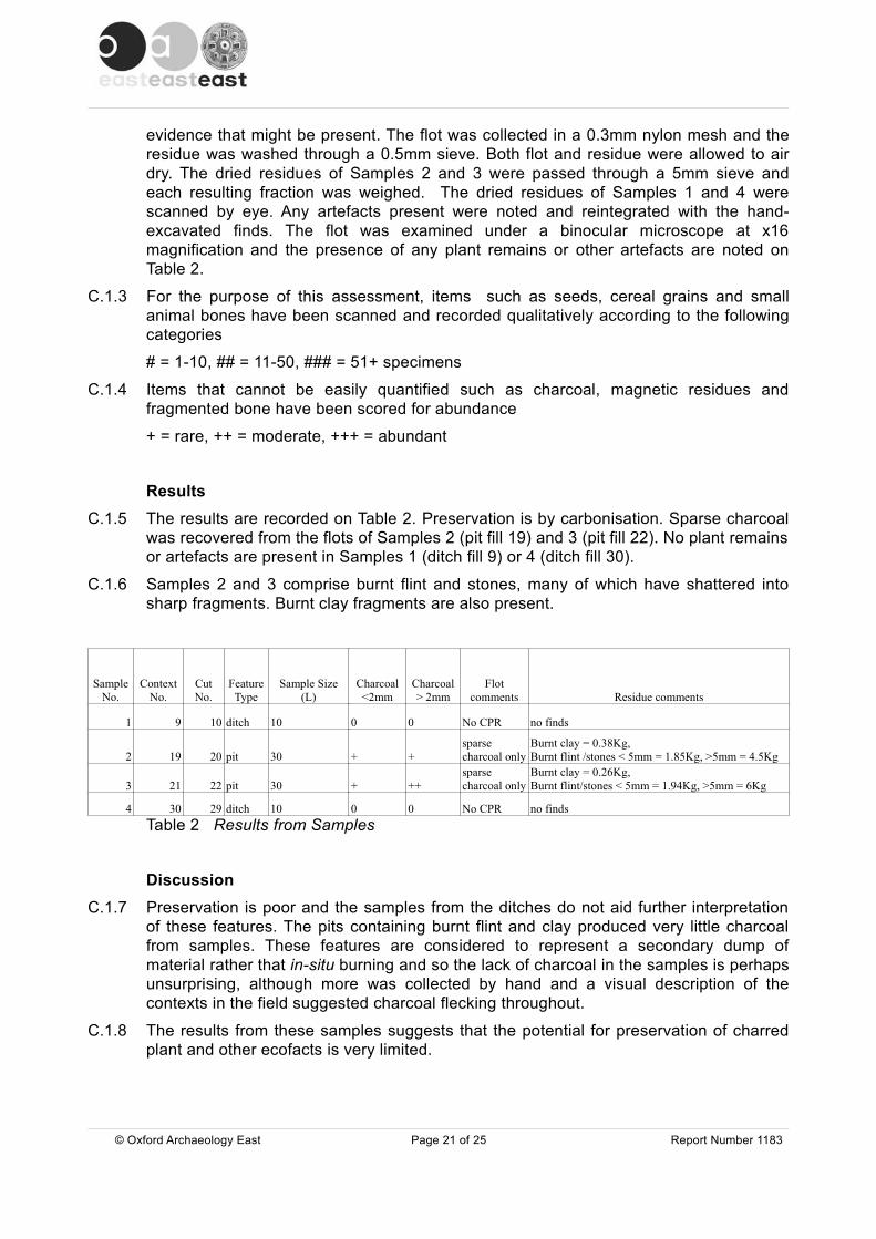
evidence that might be present. The flot was collected in a 0.3mm nylon mesh and theresidue was washed through a 0.5mm sieve. Both flot and residue were allowed to airdry. The dried residues of Samples 2 and 3 were passed through a 5mm sieve andeach resulting fraction was weighed. The dried residues of Samples 1 and 4 werescanned by eye. Any artefacts present were noted and reintegrated with the hand-excavated finds. The flot was examined under a binocular microscope at x16magnification and the presence of any plant remains or other artefacts are noted onTable 2.
C.1.3 For the purpose of this assessment, items such as seeds, cereal grains and smallanimal bones have been scanned and recorded qualitatively according to the followingcategories
# = 1-10, ## = 11-50, ### = 51+ specimens
C.1.4 Items that cannot be easily quantified such as charcoal, magnetic residues andfragmented bone have been scored for abundance
+ = rare, ++ = moderate, +++ = abundant
ResultsC.1.5 The results are recorded on Table 2. Preservation is by carbonisation. Sparse charcoal
was recovered from the flots of Samples 2 (pit fill 19) and 3 (pit fill 22). No plant remainsor artefacts are present in Samples 1 (ditch fill 9) or 4 (ditch fill 30).
C.1.6 Samples 2 and 3 comprise burnt flint and stones, many of which have shattered intosharp fragments. Burnt clay fragments are also present.
SampleNo.
ContextNo.
CutNo.
FeatureType
Sample Size(L)
Charcoal<2mm
Charcoal> 2mm
Flotcomments Residue comments
1 9 10 ditch 10 0 0 No CPR no finds
2 19 20 pit 30 + +sparsecharcoal only
Burnt clay = 0.38Kg, Burnt flint /stones < 5mm = 1.85Kg, >5mm = 4.5Kg
3 21 22 pit 30 + ++sparsecharcoal only
Burnt clay = 0.26Kg, Burnt flint/stones < 5mm = 1.94Kg, >5mm = 6Kg
4 30 29 ditch 10 0 0 No CPR no findsTable 2 Results from Samples
Discussion
C.1.7 Preservation is poor and the samples from the ditches do not aid further interpretationof these features. The pits containing burnt flint and clay produced very little charcoalfrom samples. These features are considered to represent a secondary dump ofmaterial rather that in-situ burning and so the lack of charcoal in the samples is perhapsunsurprising, although more was collected by hand and a visual description of thecontexts in the field suggested charcoal flecking throughout.
C.1.8 The results from these samples suggests that the potential for preservation of charredplant and other ecofacts is very limited.
© Oxford Archaeology East Page 21 of 25 Report Number 1183

© Oxford Archaeology East Page 22 of 25 Report Number 1183
APPENDIX D. BIBLIOGRAPHY
Atkins, R., 2010 Specification for archaeological evaluation, Land off Carey Close, Ely OA East(unpublished)
Atkins, R., and Mudd, A., 2003 An Iron Age and Romano-British settlement at Prickwillow Road,Ely. Excavations 1999-2000 Proc. Cambridge Antiq. Soc. 92, 5-55
British Geological Survey 1980 Geological survey of Great Britain (England and Wales) Elysheet 173 1:50, 000 Solid and Drift Edition
Brown, N., and Murphy, P., 2000 Neolithic and Bronze Age in Brown, N., and Glazebrook, J.,Research and Archaeology: A Framework for the Eastern Counties, 2. Research Agenda andStrategy. East Anglian Archaeology Occasional Paper No 8
Bush, L., 2008 Evaluation at Highfield School, Ely, Cambridgeshire Oxford Archaeology EastReport 1047 (Unpublished)
Dickens, A., 1997 Further archaeological Investigations at land off Prickwillow Road, Ely CAUreport 214 (unpublished)
Evans, C., Knight, M., and Webley, L., 2007 'Iron Age settlement and Romanisation on the Isleof Ely: the Hurst Lane Reservoir site', Proc. Cambridge Antiq. Soc. 96, 41-78
Haley, G., 1992 High Barns, Ely: an Archaeological Assessment CCCAFU report No. 45(unpublished)
Hall, D., 1996 The Fenland Project, Number 10: Cambridgeshire Survey, The Isle of Ely andWisbech, E. Anglian Archaeol. 79
Kemp, S., 1996 High Barns, Ely: an Archaeological Evaluation CCCAFU report 87A(unpublished)
Masser, P. 2001 Archaeological Excavations at West Fen and St John's Roads, Ely,Cambridgeshire: The Trinity and Runciman Lands. Cambridge: CAU Report 432 (unpublished)
Meadows, I., 1999 Archaeological evaluation of land off Prickwillow Road, High Barnes, ElyNorthamptonshire Archaeological report (unpublished)
Mortimer, R., Regan, R., and Lucy, S., 2005 The Saxon and medieval settlement at West FenRoad, Ely: The Ashwell Site, Cambridge, E. Anglian Archaeol. 110
Palmer 1937 Enclosures at Ely, Downham and Littleport, AD 1548 Trans. Cambs. and Hunts.Arch. Soc. V, 369-84
Robinson, B., and Bray, S., Bronze Age Activity at Ely: An Archaeological Evaluation of Land offthe A10 Ely Bypass Cambridgeshire County Council Report A128 (unpublished)
Whittaker, P., 1997 An archaeological evaluation at land off Prickwillow Road, Ely CAU report208 (unpublished)
© Oxford Archaeology East Page 23 of 25 Report Number 1183
APPENDIX E. OASIS REPORT FORM All fields are required unless they are not applicable.
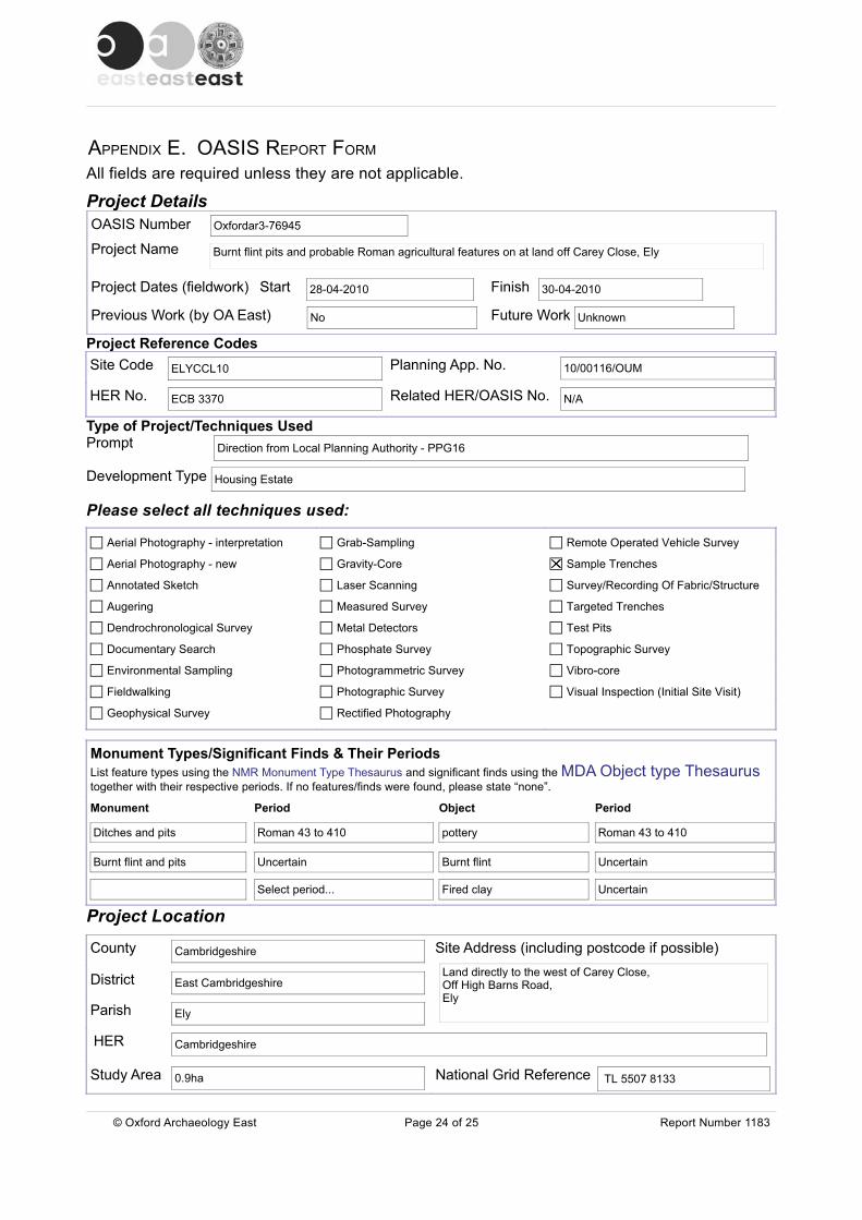
Project DetailsOASIS Number
Project Name
Project Dates (fieldwork) Start Finish
Previous Work (by OA East) Future Work
Project Reference CodesSite Code Planning App. No.
HER No. Related HER/OASIS No.
Type of Project/Techniques UsedPrompt
Development Type
Please select all techniques used:
Monument Types/Significant Finds & Their Periods List feature types using the NMR Monument Type Thesaurus and significant finds using the MDA Object type Thesaurustogether with their respective periods. If no features/finds were found, please state “none”.
Monument Period Object Period
Project Location
County Site Address (including postcode if possible)
District
Parish
HER
Study Area National Grid Reference
© Oxford Archaeology East Page 24 of 25 Report Number 1183
Ditches and pits Roman 43 to 410
Burnt flint and pits Uncertain
Select period...
Land directly to the west of Carey Close, Off High Barns Road,Ely
30-04-2010
ELYCCL10 10/00116/OUM
ECB 3370
No Unknown
Oxfordar3-76945
Burnt flint pits and probable Roman agricultural features on at land off Carey Close, Ely
Direction from Local Planning Authority - PPG16
Housing Estate
N/A
28-04-2010
Cambridgeshire
TL 5507 8133
Aerial Photography - interpretation
Aerial Photography - new
Annotated Sketch
Augering
Dendrochronological Survey
Documentary Search
Environmental Sampling
Fieldwalking
Geophysical Survey
Grab-Sampling
Gravity-Core
Laser Scanning
Measured Survey
Metal Detectors
Phosphate Survey
Photogrammetric Survey
Photographic Survey
Rectified Photography
Remote Operated Vehicle Survey
Sample Trenches
Survey/Recording Of Fabric/Structure
Targeted Trenches
Test Pits
Topographic Survey
Vibro-core
Visual Inspection (Initial Site Visit)
Roman 43 to 410
Uncertain
Uncertain
pottery
Burnt flint
Fired clay
East Cambridgeshire
Ely
Cambridgeshire
0.9ha
Project Originators
Organisation
Project Brief Originator
Project Design Originator
Project Manager
Supervisor
Project Archives
Physical Archive Digital Archive Paper Archive
Archive Contents/Media
PhysicalContents
DigitalContents
PaperContents
Digital Media Paper Media
Animal Bones
Ceramics
Environmental
Glass
Human Bones
Industrial
Leather
Metal
Stratigraphic
Survey
Textiles
Wood
Worked Bone
Worked Stone/Lithic
None
Other
Notes:
© Oxford Archaeology East Page 25 of 25 Report Number 1183
CCC Stores, Landbeach OA East CCC Stores, Landbeach
ELYCCL10 ELYCCL10 ELYCCL10
OA EAST
Rob Atkins, Project Officer OA East
Aileen Connor
Rob Atkins
Database
GIS
Geophysics
Images
Illustrations
Moving Image
Spreadsheets
Survey
Text
Virtual Reality
Aerial Photos
Context Sheet
Correspondence
Diary
Drawing
Manuscript
Map
Matrices
Microfilm
Misc.
Research/Notes
Photos
Plans
Report
Sections
Survey
N/A

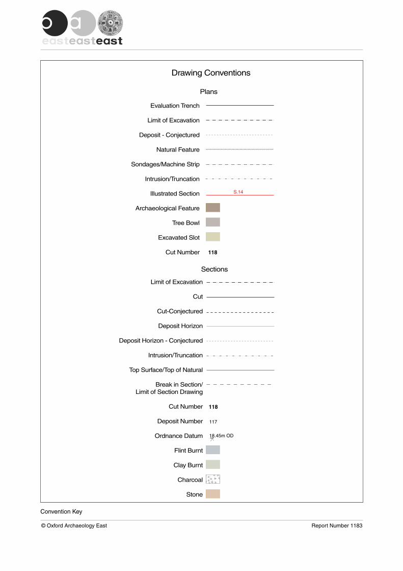
Convention Key
© Oxford Archaeology East Report Number 1183
Drawing Conventions
Sections
Limit of Excavation
Cut
Cut-Conjectured
Deposit Horizon
Deposit Horizon - Conjectured
Intrusion/Truncation
Top Surface/Top of Natural
Break in Section/Limit of Section Drawing
Cut Number
Deposit Number
Ordnance Datum
Flint Burnt
Clay Burnt
Charcoal
Stone
117
118
18.45m OD
Plans
S.14
Evaluation Trench
Limit of Excavation
Deposit - Conjectured
Natural Feature
Sondages/Machine Strip
Intrusion/Truncation
Illustrated Section
Archaeological Feature
Tree Bowl
Excavated Slot
Cut Number 118

281000
555000
Tr. 1
Tr. 2Tr. 3
Tr. 4
Tr. 5
Tr. 6
Carey Close
TL
BB
0 500m
N
B
0 2 km
A
Peterborough
Cambridge
Ely
0 25 km
King's Lynn The Fens
The Wash
Huntingdon
A
R. Cam
R. Ouse
R. Nene
Figure 1: Location of trenches (black) with the development area outlined (red)
© Crown Copyright 2010 . All rights reserved. License No. AL 100005569
© Oxford Archaeology East Report Number 1183

20
22
35
12
13
1510
31
29
27
23
25
34
36
3740
42
S.6
S.1
S.2
Trench 1
Trench 2
Trench 3
Trench 4
Trench 5
Trench 6 © O
xfor
d A
rcha
eolo
gy E
ast
Rep
ort N
umbe
r 11
83
Figure 2: Trench plans
0 25 50m
Scale 1:300
N

Section 6
Section 1
Section 2
8
2
2119
4
6
7
8
2
11
2022
12
5
3
NE SW
SE NW
SE NW
13.23m OD
13.49m OD
12.02m OD
0 1.00m
Scale 1:20
0
1.00m
Figure 3: Section drawings
© Oxford Archaeology East Report Number 1183

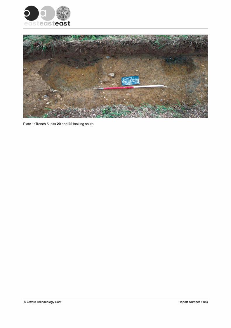
Plate 1: Trench 5, pits 20 and 22 looking south
© Oxford Archaeology East Report Number 1183


Di rec to r : Da v id Jenn ings , BA M IFA FS A
Oxfo rd A rcha eo log ica l Un i t i s aP r i va t e L im i t ed Compa ny , N o: 1618597and a Reg i s te red Char i t y , N o: 285627
OA Nor thMi l l 3Moor LaneLancas te r LA1 1GF
t : +44 ( 0 ) 1524 541 000f : +44 ( 0 ) 1524 848 606e : oanor th@thehuman jou r ney .ne tw :h t tp : / / thehuman jou r ney .ne t
Head Of f ice/Reg i s te red O f f iceJanus HouseOsney MeadOxfo rd OX2 0ES
t : +44 ( 0 ) 1865 263 800f : +44 ( 0 )1865 793 496e : i n fo@thehuman jou r ney .ne tw : h t t p : / / t h e h u m a n j o u r n e y . n e t
OA Eas t15 T r a fa lga r WayBar H i l lCambr idgesh i reCB23 8SQ
t : +44 (0 )1223 850500f : +44 (0 )1223 850599e : oaeas t@thehuman jou r ney .ne tw :h t tp : / / thehuman jou r ney .ne t /oaeas t
OA Méd i te r ranée115 Rue Mer lo tZAC La Louvade34 130 Maugu ioF rance
t : +33 ( 0 ) 4 . 67 .57 .86 .92f : +33 ( 0 ) 4 . 67 .42 .65 .93e : oamed@oamed. f rw : h t tp : / /oamed. f r /