Embed Size (px)
Citation preview

Place-Based Planning: Innovations and Applications From Four Western Forests
EditorsJennifer O. Farnum was a research social scientist, Pacific Wildland Fire
Sciences Laboratory, 400 N 34th St., Suite 201, Seattle, WA 98107. Linda E.
Kruger is a research social scientist, Forestry Sciences Laboratory, 2770 Sherwood
Lane Suite, 2A, Juneau, AK 99801.
The Forest Service of the U.S. Department of Agriculture is dedicated to the principle ofmultiple use management of the Nation’s forest resources for sustained yields of wood,water, forage, wildlife, and recreation. Through forestry research, cooperation with theStates and private forest owners, and management of the national forests and nationalgrasslands, it strives—as directed by Congress—to provide increasingly greater service to a growing Nation.
The U.S. Department of Agriculture (USDA) prohibits discrimination in all its programs andactivities on the basis of race, color, national origin, age, disability, and where applicablesex, marital status, familial status, parental status, religion, sexual orientation genetic infor-mation, political beliefs, reprisal, or because all or part of an individual’s income is derivedfrom any public assistance program. (Not all prohibited bases apply to all programs.)Persons with disabilities who require alternative means for communication of program infor-mation (Braille, large print, audiotape, etc.) should contact USDA’s TARGET Center at (202)720-2600 (voice and TDD).
To file a complaint of discrimination, write USDA, Director, Office of Civil Rights,1400Independence Avenue, S.W. Washington, DC 20250-9410 or call (800) 795-3272 (voice) or (202) 720-6382 (TDD). USDA is an equal opportunity provider and employer.
Place-Based Planning: Innovations and Applications From Four Western Forests
Jennifer O. Farnum and Linda E. Kruger
Editors
U.S. Department of Agriculture, Forest Service
Pacific Northwest Research Station
Portland, OR
General Technical Report PNW-GTR-741
April 2008

This page is intentionally left blank.
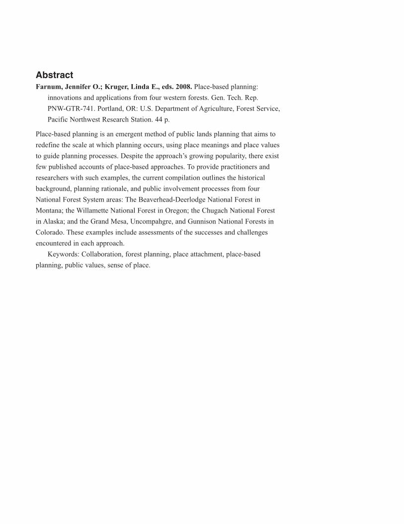
AbstractFarnum, Jennifer O.; Kruger, Linda E., eds. 2008. Place-based planning:
innovations and applications from four western forests. Gen. Tech. Rep.
PNW-GTR-741. Portland, OR: U.S. Department of Agriculture, Forest Service,
Pacific Northwest Research Station. 44 p.
Place-based planning is an emergent method of public lands planning that aims to
redefine the scale at which planning occurs, using place meanings and place values
to guide planning processes. Despite the approach’s growing popularity, there exist
few published accounts of place-based approaches. To provide practitioners and
researchers with such examples, the current compilation outlines the historical
background, planning rationale, and public involvement processes from four
National Forest System areas: The Beaverhead-Deerlodge National Forest in
Montana; the Willamette National Forest in Oregon; the Chugach National Forest
in Alaska; and the Grand Mesa, Uncompahgre, and Gunnison National Forests in
Colorado. These examples include assessments of the successes and challenges
encountered in each approach.
Keywords: Collaboration, forest planning, place attachment, place-based
planning, public values, sense of place.
Contents1 Chapter 1: An Introduction to Place-Based Planning
Linda E. Kruger
1 Exploring New Approaches to Forest Planning
1 Foundational Concepts
2 Place-Based Planning Processes
3 Considerations in Using Place-Based Planning Processes
4 Case Description Format
4 Literature Cited
7 Chapter 2: The Beaverhead-Deerlodge National Forest
Jennifer O. Farnum, Anita DeZort, and Janet Bean-Dochnahl
7 Overview of the Area
7 Project Rationale
8 Methods, Techniques, and Participants
12 Benefits and Challenges of Using the BDNF’s Approach
15 Chapter 3: The Willamette National Forest
Jennifer O. Farnum, Kevin Preister, and Patti Rodgers
15 Overview of the Area
15 Project Rationale
16 Methods, Techniques, and Participants
20 Benefits and Challenges of Using the WNF’s Approach
23 Chapter 4: The Chugach National Forest
Jennifer O. Farnum and Patrick Reed
23 Overview of the Area
23 Project Rationale
24 Methods, Techniques, and Participants
28 Benefits and Challenges of Using the CNF’s Approach
33 Chapter 5: The Grand Mesa, Uncompahgre, and Gunnison National
Forests
Antony S. Cheng and Carmine Lockwood
33 Overview of the Area
33 Project Rationale
34 Methods, Techniques, and Participants
38 Benefits and Challenges of Using the GMUG’s approach
41 Chapter 6: Conclusion
Jennifer O. Farnum and Linda E. Kruger
44 Acknowledgments
Chapter 1: An Introduction to Place-Based PlanningLinda E. Kruger
Exploring New Approaches to Forest Planning“Place-based planning” refers to land and natural resource planning efforts that
bring together diverse human values, uses, experiences, and activities tied to spec-
ific geographic locations. Although planning efforts have always focused on spe-
cific places through land use zoning frameworks, place-based planning is different
from other types of approaches. For example, whereas land use zoning segregates
dominant uses from one another on the landscape, place-based planning takes a
more holistic approach, focusing on identifying current uses, values, and meanings.
In addition, place-based approaches tend to take a longitudinal perspective, explor-
ing desired future conditions for the landscape. This approach enables participants
to identify a variety of uses that might occur concurrently rather than designating
one primary use for the upcoming 10 to 20 years.
Land managers use a variety of processes, activities, and forums to identify
and spatially depict how people value and use landscapes. Forest plan revision,
a process required by the 1976 National Forest Management Act (NFMA), has
enabled place-based techniques to emerge on forests throughout the National Forest
System. Although there are many innovative place-based approaches, there is little
in the way of summary and synthesis of these approaches. The purpose of this
report is to provide examples of place-based planning with an emphasis on practi-
cal applications, tools, and techniques. First we explore some foundational
concepts underlying this approach.
Foundational ConceptsPlace-oriented approaches to natural resource and community issues are receiving
increasing attention from academics, policymakers, citizens, and resource managers
(see Farnum et al. 2005). The concepts of sense of place, attachment to place, and
place-based planning are appearing more frequently in academic literature, agency
publications, and the popular press. This attention is indicative of the fact that place
values are important components of the way people appreciate, enjoy, and experi-
ence the environment (Ehrendfeld 1993, Norton and Hannon 1997).
Place values are
important compo-
nents of the way
people appreciate,
enjoy, and experience
the environment.
1
Place-Based Planning: Innovations and Applications from Four Western Forests
Place is a multidimensional term used by social scientists in four ways; these
four conceptions are used independently and in combination with each other to
express and understand the multiple meanings and uses of a place (Agnew and
Duncan 1989). As location, place refers to the way social and economic activities
spatially occur on the land. Place as locale recognizes place as the setting or back-
drop for everyday activities. Sense of place involves individual or group identi-
fication with a place that comes from personally interacting with it and experi-
encing it with one’s senses. This type of identification with a place can result in
appreciation and attachment beyond the observable features of the landscape (i.e.,
place attachment).
We suggest that existence attachment can be used to describe a concept
related to place attachment, a term that refers to an appreciation of and attachment
to a place that one has not experienced first hand.1 Thus, existence attachment is a
concept closely akin to existence value, a concept in environmental economics that
has long been used as a method for valuing lands (Krutilla 1967). Existence value
is predicated on the idea that the knowledge of natural resources’ existence is in its
own right an important benefit of maintaining such resources (e.g., Fredman 1995).
Thus, people with strong sentiments toward places they have never visited (e.g.,
Yellowstone National Park or the Galapagos Islands) can be said to have existence
attachment (often owing to an area’s symbolic or cultural value), whereas the land
itself can be said to hold existence value.
Place-Based Planning ProcessesSlowly, sometimes in fits and starts, planning processes have begun to recognize
the importance of place attachment—the emotional ties and feelings of connected-
ness that people have for places—and the intangible (e.g., cultural, symbolic, and
spiritual) meanings and values people ascribe to places (Galliano and Loeffler
1999). Place-related concepts are becoming better understood, and managers are
finding value in the contribution these concepts make to planning and management
applications (Norton and Hannon 1998).
An essential idea behind place-based planning is that caring about places is
important and different from caring about resources (Mitchell et al. 1993). There is
a difference between valuing a resource (or even what some might call a type of
place such as wilderness) and valuing a place that might contain that resource or
belong to that particular type of place. Place-based planning brings to bear the
General Technical Report GTR-741
2
1 Thanks to Dale Blahna for help in differentiating existence attachment from sense of place.
meanings, values, and attachments associated with a specific location in addition to
any meaning it might have as a type of place or container of a resource.
Understanding the significant meanings that places have for individuals and
groups may enable planners, managers, and decisionmakers to develop manage-
ment guidelines that preserve the characteristics that make those places important
(Galiano and Loeffler 1999). Thus, place-based planning provides an opportunity
to:
• Empower community members and build camaraderie.
• Establish positive relationships and trust.
• Enable participants (both from the agency and the public) to regain
credibility that may have been diminished or lost in previous planning
activities.
• Engage in mutual learning.
• Explain policies and rationale.
• Surface and mitigate conflict.
• Plan holistically.
• Incorporate a broad range of place meanings into planning and management.
• Focus on stakeholder similarities rather than differences.
• Encourage positive outcomes by addressing underlying sources of conflict.
Considerations in Using Place-Based Planning ProcessesPlace-based planning processes allow managers to interact with people who live,
work, and play in a place and who care about it. This is important because planning
in itself is a place-making or meaning-creating process (Galliano and Loeffler
1999; Williams and Patterson 1996, 1999). Place-based planning engages the pub-
lic and enables an understanding of what Clarke (1971, quoted in Galiano and
Loeffler 1999) calls “the interactive unity of people and place.”
Although in theory meaning can be mapped like other spatial properties, there
are at least two problems with identifying and mapping intangible meanings. First,
by definition, intangible meanings leave few (if any) physical indicators, behavioral
evidence, or cultural markers in the landscape to indicate they exist. Second, places
typically do not have a single set of meanings held by everyone (Greider and
Garkovich 1994). For managers to identify the full range of meanings requires an
expanded set of inventory techniques that are capable of identifying intangible
meanings and that are sensitive to the social or group differences in such meanings
(Kruger and Williams 2007).
3
Place-Based Planning: Innovations and Applications from Four Western Forests
In addition to mapping components or activities, place-based approaches also
frequently involve a visioning exercise. Visioning is intended to “create…more
equitable, democratic ways of defining, expressing, and valuing places” (Cheng et
al. 2003: 101). It is seen as a way to build relationships and share power, and
acknowledges that a “one-size-fits-all” planning template is inappropriate because
it does not recognize the uniqueness of each landscape and situation.
Knowledge of the politics of place can help managers understand natural
resource conflict and better evaluate the potential effectiveness of decisionmaking
processes. Understanding contested meanings of place is important for managers
because sense of place, existence attachment, and place meanings are expressed
through attitudes and expectations about appropriate and inappropriate management
or use (Cheng et al. 2003).
Case Description FormatA workshop on place-based planning was held on November 5–7, 2003, in
Portland, Oregon, to provide a venue for Forest Service planners and others to
share their experiences in implementing place-oriented planning techniques. The
goal of the workshop was to increase awareness about how place-based approaches
have been applied and the unique benefits and challenges associated with each one.
Workshop attendees were identified through word-of-mouth and prior work
with the Pacific Northwest Research Station. Participants came from Alaska,
California, Colorado, Idaho, Montana, Utah, and Washington. The current collec-
tion consists of four short vignettes, all of which were presented at the workshop.
This collection contributes to our understanding of how place-based appro-
aches are being applied across a variety of divergent biophysical settings and socio-
cultural environments. We worked closely with managers and others involved in
the projects to present their approaches as honestly and transparently as possible.
Our hope is that these vignettes will provide managers and research scientists
with additional insight into the role place plays in how people relate to the land.
Providing tangible, application-oriented examples of these approaches allows us to
continue to build a community of managers and researchers who can help further
best practices.
Literature CitedAgnew, J.A.; Duncan, J.S. 1989. Introduction. In: Agnew, J.A.; Duncan, J.S., eds.
The power of place. Boston: Unwin Hyman: 1–8.
Knowledge of the
politics of place can
help managers
understand natural
resource conflict and
better evaluate the
potential effective-
ness of decision-
making processes.
General Technical Report GTR-741
4
Cheng, A.S.; Kruger, L.E.; Daniels, S.E. 2003. “Place” as an integrating concept
in natural resource politics: propositions for a social science research agenda.
Society and Natural Resources. 16(2): 87–104.
Clarke, W.C. 1971. Place and people: an ecology of a New Guinean community.
Berkeley, CA: University of California Press. 127 p.
Ehrenfeld, D. 1993. Beginning again: people and nature in the new millennium.
New York: Oxford University Press. 240 p.
Farnum, J.O.; Hall, T.E.; Kruger, L.E. 2005. Sense of place in natural resources
recreation and tourism: an evaluation and assessment of research findings. Gen.
Tech. Rep. PNW-GTR-660. Portland, OR: U.S. Department of Agriculture,
Forest Service, Pacific Northwest Research Station. 59 p.
Fredman, P. 1995. The existence of existence value—a study of the economic
benefits of an endangered species. Journal of Forest Economics. 1(3): 307–327.
Galliano, S.J.; Loeffler, G.M. 1999. Place attachments: how people define eco-
systems. Gen. Tech. Rep. PNW-GTR-462. Portland, OR: U.S. Department of
Agriculture, Forest Service, Pacific Northwest Research Station. 31 p.
Greider, T.; Garkovich, L. 1994. Landscapes: the social construction of nature
and the environment. Rural Sociology. 59(1): 1–24.
Kruger, L.E.; Williams, D.R. 2007. Place and place-based planning. In: Kruger,
L.E.; Mazza, R.; Lawrence, K., eds. Proceedings: national workshop on recre-
ation research and management. Gen. Tech. Rep. PNW-GTR-698. Portland,
OR: U.S. Department of Agriculture, Forest Service, Pacific Northwest
Research Station: 83–88.
Krutilla, J.V. 1967. Conservation reconsidered. The American Economic Review.
57: 777–786.
Mitchell, M.Y.; Force, J.E.; Carroll, M.S.; McLaughlin, W.J. 1993. Forest
places of the heart. Journal of Forestry. 91(4): 32–37.
Norton, B.G.; Hannon, B. 1997. Environmental values: a place-based theory.
Environmental Ethics. 19(4): 227–245.
Norton, B.G.; Hannon, B. 1998. Democracy and sense of place values in environ-
mental policy. In: Light, A.; Smith, J.M., eds. Philosophy and geography III:
philosophies of place. Lanhan, MD: Rowman and Littlefield Publishers Inc:
119–145.
5
Place-Based Planning: Innovations and Applications from Four Western Forests
Williams, D.R.; Patterson, M.E. 1996. Environmental meaning and ecosystem
management: perspectives from environmental psychology and human geogra-
phy. Society and Natural Resources. 9(5): 507–521.
Williams, D.R.; Patterson, M.E. 1999. Environmental psychology: mapping
landscape meanings for ecosystem management. In: Cordell, H.K.; Bergstrom,
J.C., eds. Integrating social sciences and ecosystem management: human
dimensions in assessment, policy and management. Champaign, IL: Sagamore
Press: 141–160.
General Technical Report GTR-741
6
Chapter 2: The Beaverhead-DeerlodgeNational ForestJennifer O. Farnum, Anita DeZort, and Janet Bean-Dochnahl
Overview of the AreaThe Beaverhead-Deerlodge National Forest (BDNF) is in the southwestern corner
of Montana, surrounded by the communities of Dillon, Ennis, Butte, Boulder, and
Deerlodge. The landscape consists of mountain ranges separated by valleys, towns,
and agricultural areas. A variety of forest densities can be found on the BDNF (i.e.,
from heavily to sparsely forested) as well as large areas of grasslands.
The 3.32-million-acre forest is noncontiguous, interspersed with U.S.
Department of the Interior, Bureau of Land Management, and privately owned
parcels. The BDNF is home to two wilderness areas (Anaconda-Pintler and Lee
Metcalf) and two proposed wilderness areas (West Pioneers and Sapphires). A
variety of recreational activities are popular on the BDNF including snowmobiling,
skiing, hiking, and scenic driving.
The history of the BDNF area is one of its most prominent characteristics.
Before settlement by nonindigenous people, the land served as a main crossroads
for Native American tribes. Shortly after the arrival of nonindigenous people in the
mid-1800s, the railroad was introduced to the area, which had a lasting effect on
the area’s culture and settlement patterns. At about the same time, mining assumed
an important role in the region’s economic base. Today, mining continues to be a
major player in culture and economy; ranching and grazing, too, have become
mainstays in the region.
Project RationaleWhen this project was first initiated in the early 1990s, the BDNF region was
experiencing growth on two fronts: (1) migration of newcomers to the small com-
munities surrounding the forest, newcomers moving to the area to experience the
“Rocky Mountain West;” and (2) rising levels of tourism in Montana. The BDNF’s
location between two major interstates, Interstate 90 and Interstate 15, contributed
to the influx of both new residents and tourists.
The BDNF planners and managers recognized that changes in seasonal and
year-round populations would inevitably lead to changes in communities’ cultures
Planners and
managers recognized
that changes in sea-
sonal and year-round
populations would
inevitably lead to
changes in com-
munities’ cultures
and, by extension,
land management
priorities.
7
Place-Based Planning: Innovations and Applications from Four Western Forests
and, by extension, land management priorities. Producing a forest plan that incor-
porated the dynamic nature of community needs and preferences required a depar-
ture from traditional, static, expert-driven planning processes.
The BDNF also felt pressure to produce a first-rate forest plan because of
contention that had arisen during previous planning processes. In the two previous
forest planning endeavors, management areas had been very small and determined
by criteria driven by the biophysical sciences for the purposes of timber production.
Management areas were so small that they were challenging for the public to visu-
alize. As a result, difficulty was encountered in developing shared understandings
of the area, inevitably hindering communication between the U.S. Department of
Agriculture, Forest Service and the public. Disputes between the public and the
agency ensued and relationships became strained. Thus, the goal of this approach
was to simultaneously recognize preexisting concerns while being attuned to new
values, beliefs, and social structures that were arising as a result of changing popu-
lations. To do so, planners focused on identifying the public’s priorities for the
BDNF and rescaling management area boundaries to make them more meaningful.
Methods, Techniques, and ParticipantsWhen the BDNF first began to consider its upcoming forest plan revision, the idea
of place-based planning or socially driven management approaches was not as
developed as it is today. Because there was little precedent for such approaches,
BDNF planners adopted an adaptive management style that allowed for flexibility
within their general planning framework.
The initial task that planners undertook was to segment the forest into large
parcels of land, or forest landscapes. The goals of segmentation were to make the
revision process more manageable and, at the same time, better represent the scale
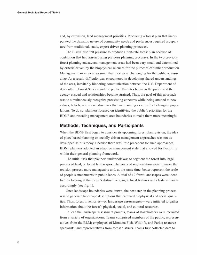
of people’s attachments to public lands. A total of 12 forest landscapes were identi-
fied by looking at the forest’s distinctive geographical features and clustering areas
accordingly (see fig. 1).
Once landscape boundaries were drawn, the next step in the planning process
was to generate landscape descriptions that captured biophysical and social quali-
ties. Thus, forest inventories—or landscape assessments—were initiated to gather
information about the forest’s physical, social, and cultural resources.
To lead the landscape assessment process, teams of stakeholders were recruited
from a variety of organizations. Teams comprised members of the public; represen-
tatives from the BLM; employees of Montana Fish, Wildlife, and Parks; resource
specialists; and representatives from forest districts. Teams first collected data to
General Technical Report GTR-741
8
determine landscapes’ resource potential, looking at such factors as range of vege-
tation, watershed quality, and historical human uses. By looking at existing infor-
mation and sharing expertise, teams evaluated the landscapes’ current conditions
and tried to determine how much those conditions differed from historical condi-
tions. Teams sought to gauge how the forest had evolved and how the biological,
social, and cultural constitution of the area would likely change (i.e., the forest’s
future conditions).
To better understand the social and cultural constitution of landscapes, the
public was consulted regularly. The way in which this occurred varied depending
on the availability of resources and the interest level of BDNF staff. In some cases,
informal discussions were initiated based on ranger district personnel’s knowledge
of communities. Arguably, this technique may not have captured an accurate cross-
section of public sentiment. However, other techniques were more inclusive and
methodical. Public meetings—at least initially—seemed to attract a diversity of
people and options. Representatives from federal and state agencies, county gov-
ernment, the Montana Wilderness Association, the Montana Logging Association,
grazing associations, chambers of commerce—all attended these well-advertised
meetings.
9
Place-Based Planning: Innovations and Applications from Four Western Forests
Figure 1—The 12 landscapes identified for the Beaverhead-DeerlodgeNational Forest.
For the public meetings, Forest Service staff underwent specialized training in
facilitation; thus, they were able to lead meaningful discussions that provided the
BDNF with a clearer idea of public priorities and attachments to forest places.
Participants were encouraged to think about what determines a “place,” what
distinct places exist on the BDNF, what places mean to them, and, based on these
meanings, the appropriate uses for places both currently and in the future.
Partway into the planning process, a Montana Consensus Council survey
revealed that many people had grown weary of public meetings and wanted differ-
ent forums to provide input. To accommodate this preference, the BDNF arranged
for the forest planner to provide presentations and receive feedback about the plan-
ning products (i.e., planning documents) and processes at various venues. This
format of sharing information was appreciated, and hundreds of presentations were
made to interested parties. Ultimately, citizens were highly involved in 3 of the 12
landscapes assessments; changes in funding and the political climate prevented full
public involvement in the remaining nine landscapes.
As a result of the sentiments expressed at meetings and presentations, the land-
scape assessments reflected participants’ place meanings and place attachments.
Although multiple forest uses were discussed in the assessments, the assessments
were organized around the quality that was most valued by the largest number of
people—the forest’s recreational capacity.
During the course of landscape assessments, it became clear that the landscapes
themselves—while smaller in scale than the entire forest—were still too large to
develop targeted recommendations that accurately captured the public’s place
meanings and attachments. Meetings and presentation feedback continually rein-
forced the idea that citizens thought of the forest at a finer scale than larger “land-
scapes” permitted. Planners also recognized that they needed to generate products
that met National Environmental Policy Act (NEPA) and forest plan requirements.
Thus, smaller, more discrete management areas were carved out of the larger land-
scapes, which in turn were intended to lay the groundwork for developing forest
planning documents.
The process of deriving management areas from landscapes rested on a detailed
evaluation of public input and zoning area considerations. To avoid some of the
problems with management area zoning that had been encountered in previous for-
est plan revisions, several criteria were employed including (1) management area
boundaries must be identifiable on the ground, (2) the recreation setting must be
similar throughout the area, and (3) management priorities should be fairly uniform
across the identified area. When evaluating these criteria, planners also considered
General Technical Report GTR-741
10
preexisting social and biophysical information about (for example) wildlife popula-
tions, road densities, timber harvests, and population trends.
Public feedback, social and biophysical information, and consideration of the
three aforementioned criteria enabled delineation of distinct management areas.
Integrating the various data sources meant that some management areas had bound-
aries that were intuitive—for example, road corridors or wilderness—while other
boundaries were less obvious, informed by people’s relationships with the land and
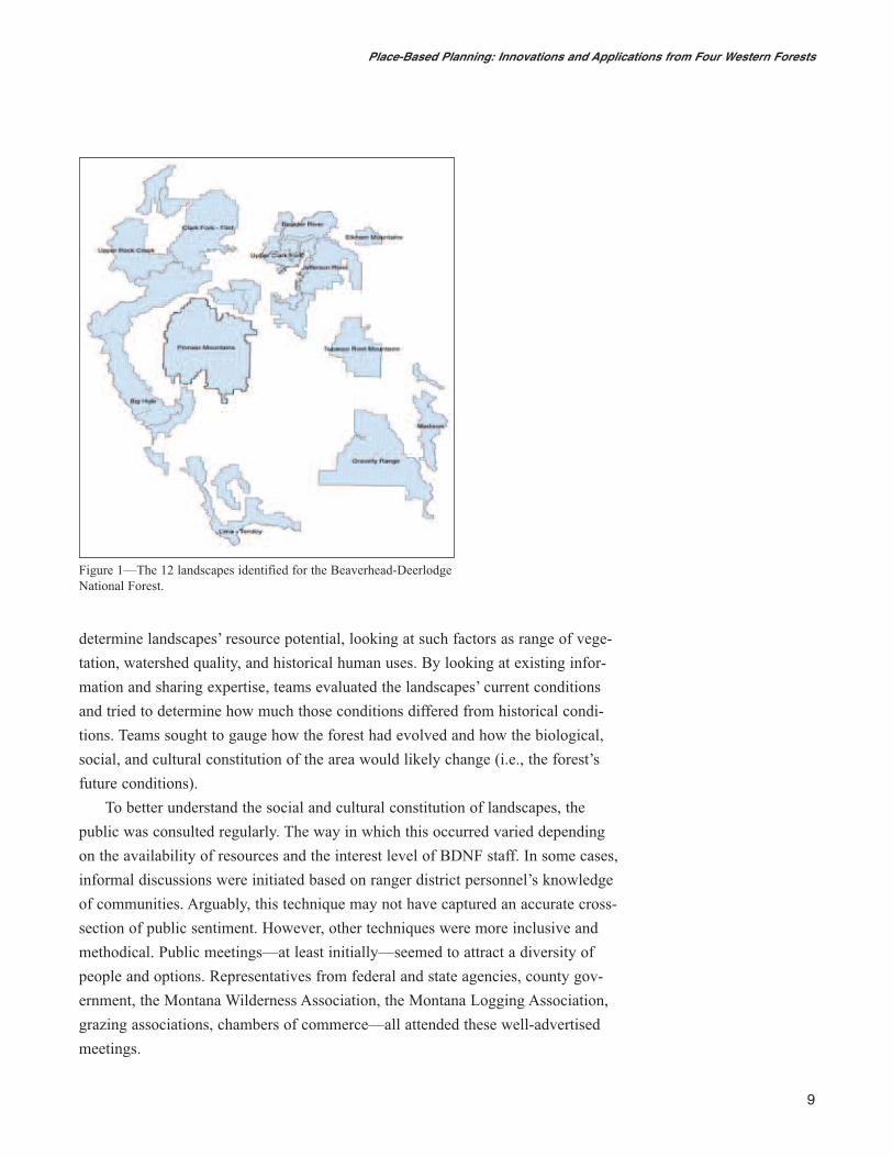
the values and meanings associated with specific landscapes. From the 12 land-
scape assessments, planners devised approximately 100 management areas, each
averaging 30,000 acres (12 150 ha; see fig. 2 for an example).
Each management area carried with it a set of descriptions and prescriptions
similar to those that would ordinarily be created during the planning process. This
information was intended to be directly incorporated into the forest plan revision
and associated legal documents.
11
Place-Based Planning: Innovations and Applications from Four Western Forests
Figure 2—Management areas from a selected section of the PioneerMountains landscape.
Currently (2007), the BDNF is working on its final environmental impact statement
(EIS), the record of decision, and the final forest plan. Although there are aspects
of the plan that draw upon the work described here, for the most part, the upfront
work done with the landscape assessments has been disregarded. Place-specific
recommendations and feedback were not ultimately used to develop alternatives,
primarily because the planning process was not universally embraced by other
stakeholders within the agency (see following section on challenges).
Benefits and Challenges of Using the BDNF is ApproachWith its place-based approach, the current project sought to redefine (or add to) the
scale at which forest planning typically occurs. Rather than relying on zoning stan-
dards popular in biophysical sciences (e.g., timber stands), this approach prioritized
people’s relationships to the land by determining the public’s ideas of what consti-
tutes “place” and defining management areas accordingly. The most challenging
aspect of this project was (and continues to be) attaining buy-in from factions with-
in the forest planning team. Much of the upfront work that was completed for this
project was discounted during advanced stages of forest planning. Because place-
based planning does not “fit” into any preestablished model of forest planning,
disinterested parties can—if they choose—disregard recommendations altogether.
In terms of barriers within the process itself, one significant obstacle involved
the EIS. The EIS gave rise to a variety of value-laden debates within stakeholder
groups. Some user groups expressed concern that the identified management areas
were not appropriately defined (specifically, the recommended wilderness man-
agement areas), or that recommendations for appropriate uses were problematic.
Others were satisfied with these distinctions, and some intergroup controversy
ensued.
In addition to debates among user groups, there was also a fair amount of
intragroup conflict within landscape assessment teams. Areas of contention often
centered on the concerns specialists voiced in relation to the environmental effects
of human uses, particularly recreational uses. Differences in values, language,
processes, and priorities led to clashes between individuals’ viewpoints and inhi-
bited progress toward final goals and products.
Originally, planners envisioned that the relationship between landscapes and
management areas would be fairly seamless—bottom-up (management area to for-
est) and top-down (forest to management area) planning would flow naturally. The
two scales were intended to be reciprocally useful in developing recommendations.
General Technical Report GTR-741
12
However, insights gleaned from the juxtaposition of broad- and fine-level scales
were not used to inform the final forest plan. The process proved complicated and
controversial, partially because the regulatory environment for developing a revised
forest plan is much more stringent than the preplanning environment under which
the landscape assessments and management area development occurred. However,
the sociopolitical climate of the planning process—differing agendas, varied foci,
and competing beliefs about how forest planning “should” occur—also contributed
to the loss of much of the original detail found in the landscape and management
area assessments. In the end, the final plan did not reflect scale blending to the
degree that planners had originally anticipated.
In this process, the issue of scale created much contention. For many stake-
holders—both public and within-agency—this project raised philosophical con-
cerns. Although these concerns are not new to forest planners, they became more
pronounced in the context of this scenario. Questions raised included: How can (or
should) site-specific information and directives apply at the forest level and vice
versa? Is one paradigm (forest-level planning or smaller, place-specific planning)
more appropriate? Contributing to the debates about scale was the challenge of
integrating different types of data. Combining discipline-specific information (e.g.,
wildlife data) with place-specific and forest-wide considerations presented a chal-
lenging scenario. Integrating quantitative data (e.g., projected recreation trends)
with qualitative data (e.g., place meanings) added an additional layer to the mix
of considerations.
Looking at the advantages of this approach, one prominent benefit was its
positive public reaction. As mentioned previously, some debate arose during the
EIS process. However, compared to the controversy that often accompanies plan-
ning processes, the approach was well received. Because management areas were
designed to be meaningful to members of the public, citizens were able to visualize
areas and, consequently, make informed recommendations about how they would
prefer the areas to be managed. In this way, potential miscommunication among
parties was thwarted; the relationship between planning and place became more
tangible.
Along similar lines, another advantage of this approach is that it fostered
dialogue among a variety of different stakeholders, stakeholders who in the past
had little interaction. County commissioners, land management agencies such as
the BLM, interest groups, the landscape assessment team—many of these parties
worked side-by-side to reach mutual understandings of place and to determine how
changes to the landscape might affect stakeholders. As a result of increased interac-
Because management
areas were designed
to be meaningful to
members of the
public, citizens were
able to visualize areas
and, consequently,
make informed
recommendations
about how they would
prefer the areas to
be managed.
13
Place-Based Planning: Innovations and Applications from Four Western Forests
tion among stakeholders, potential conflicts were circumvented before they became
problematic. Notably, the ease with which this occurred was more pronounced at
the smaller, management area level; at the more abstract forest planning level, it
became increasingly difficult to reach agreement and develop shared understand-
ings.
The approach undertaken on the BDNF ultimately suited two separate (though
related) goals: (1) large-scale planning—forest planning—as informed by land-
scape assessments, and (2) smaller scale planning—management area planning—
intended to adopt a more refined vision of forest and community functioning and
capture the interaction between management areas and the forest as a whole. These
goals allowed for two levels of a forest plan: one targeted to individual manage-
ment areas that carried with it a set of management prescriptions, the other targeted
to broader, general mandates about forest operations. Having this duality of scale
addressed many place-specific stakeholder concerns and permited decisions to be
framed within macro- and micro-level perspectives.
For more information about the BDNF’s approach, contact:
Anita DeZort
Recreation Specialist
Ashley National Forest
355 North Vernal Ave.
Vernal, UT 84078
Phone: (435) 781-5192
E-mail: [email protected]
Janet Bean-Dochnahl
Landscape Planner
Beaverhead-Deerlodge National Forest
Madison Ranger District
5 Forest Service Rd.
Ennis, MT 59729
Phone: (406) 682-4253
E-mail: [email protected]
General Technical Report GTR-741
14
Chapter 3: The Willamette NationalForestJennifer O. Farnum, Kevin Preister, and Patti Rodgers
Overview of the AreaLocated in western Oregon, the Willamette National Forest (WNF) extends along
110 miles of the west side of the Cascade Mountains. Covering nearly 1.7 million
acres (687 965 ha), the forest lies in proximity to several major municipalities,
including Salem, Corvallis, Portland, Eugene, and Bend. Designated wilderness
areas (Opal Creek, Mount Jefferson, Middle Santiam, Menagerie, Mount
Washington, Three Sisters, Waldo Lake, and Diamond Peak) make up approxi-
mately one-fifth of the WNF land mass. Because of its location and climate, the
WNF provides an ideal habitat for a variety of plants and animals, including threat-
ened species such as the spotted owl (Strix occidentalis caurina).
Lush, mountainous terrain and the remaining old-growth forests make the
WNF highly prized for its scenic value. Views of the forest’s seven volcanic peaks
dominate much of the landscape; its five scenic byways offer many spectacular
vistas. The WNF’s rivers, particularly the North and South Santiam, McKenzie,
and the Willamette, are also regional icons.
Diverse recreational opportunities exist as a result of the WNF’s varied geogra-
phy. Some of the most popular activities include day and overnight hiking, winter
motorized and nonmotorized recreation, and water-based activities such as fishing,
boating, and swimming.
Project RationaleOver the past decade, the importance of recreation in the WNF area has increased
exponentially. Timber production—formerly one of the most defining aspects of
lifestyles in rural areas surrounding the WNF—has decreased sharply. As a result,
communities are transitioning from forest-products-based economies to recreation-
and tourism-based economies. Both rural and urban areas are growing, quickly
being discovered by tourists, retirees, and others looking for the types of amenities
afforded by the area’s natural resources.
In light of these social changes, the main goal of this project was to provide
the WNF with indepth cultural and economic descriptions of communities sur-
rounding the forest. By looking at communication networks, social and economic
15
Place-Based Planning: Innovations and Applications from Four Western Forests
infrastructures, and community members’ perceptions of the meanings associated
with natural resources, the WNF hoped to better anticipate political trends and
stakeholder needs.
Unlike some of the other case examples in this publication, the WNF project
was not undertaken as a direct extension of the forest planning process. Rather, the
project was initiated in order to take a proactive approach to understanding public
perceptions of forest lands and surrounding communities.
Recognition of the need to better understand public attitudes arose in part
owing to a pilot roads analysis conducted on the WNF several years prior to the
current project. During the course of the analysis, it became evident that public
opinions regarding Forest Service activities were not well understood by the
agency; considerable gaps existed in terms of how accurately the agency perceived
public priorities and vice versa. Thus, the WNF wanted to encourage a more per-
sonal level of public-agency interaction by providing nontraditional forums for
stakeholder input.
Methods, Techniques, and ParticipantsThis project adopted an ethnographic methodology, meaning that researchers
became deeply immersed in communities in order to understand public attitudes,
values, and behaviors. Researchers employed the Discovery ProcessTM1 to aid in
their endeavors, a process premised on the idea that substantive communication
occurs most effectively when members of the public are approached in everyday
environments and one-to-one or small group contexts.
Before speaking with members of the public, though, researchers first had
to broadly define the project’s geographical scales. Based on past experience,
researchers found the simultaneous use of three geographical scales to be most
advantageous in conducting community studies: the social resource unit (SRU),
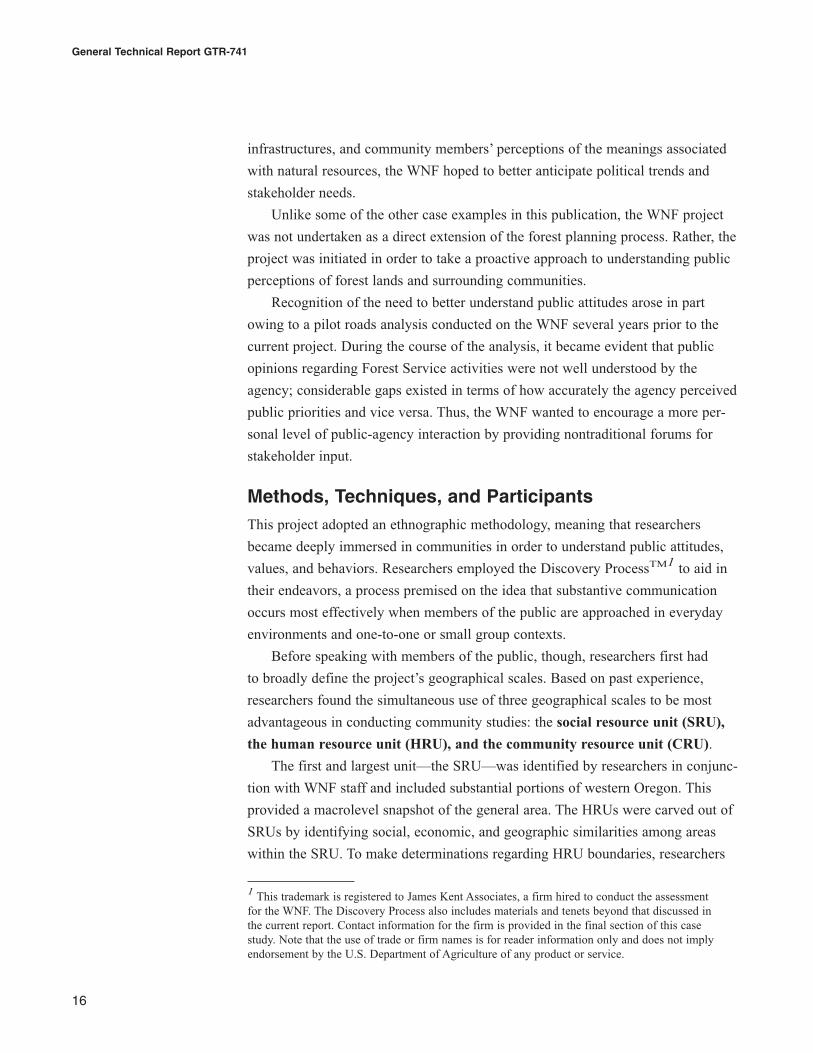
the human resource unit (HRU), and the community resource unit (CRU).
The first and largest unit—the SRU—was identified by researchers in conjunc-
tion with WNF staff and included substantial portions of western Oregon. This
provided a macrolevel snapshot of the general area. The HRUs were carved out of
SRUs by identifying social, economic, and geographic similarities among areas
within the SRU. To make determinations regarding HRU boundaries, researchers
General Technical Report GTR-741
16
1 This trademark is registered to James Kent Associates, a firm hired to conduct the assessmentfor the WNF. The Discovery Process also includes materials and tenets beyond that discussed inthe current report. Contact information for the firm is provided in the final section of this casestudy. Note that the use of trade or firm names is for reader information only and does not implyendorsement by the U.S. Department of Agriculture of any product or service.
assessed seven cultural indicators: publics (i.e., an identified set of people who
share similar interests or demographics), settlement patterns (i.e., the population
distribution), formal and informal communication networks (e.g., familial relation-
ships or membership in organizations), work routines (types and location of
employment), support services (e.g., health care or law enforcement), recreational
activities, and geographic and natural features. Based on how these indicators coa-
lesced, three HRUs were formed: the greater Salem HRU, the Mid-Valley HRU,
and the South Willamette HRU (see fig. 3. Note that smaller units (CRUs) are also
delineated on this map; these units are discussed later in the chapter).
Because the area was settled east to west, settlement patterns were especially
important in forming the HRUs. Settlers “jumped” over the mountains, landing in
the Willamette Valley and then returned back to the east. Thus, the east and west
HRU boundaries are situated at the crest of mountains—the Cascade Mountains on
the east and the Coast Range on the west. These mountains divided communities
historically and are still important cultural markers in terms of differentiating
people on “either side of the hill.”
Identifying SRUs and HRUs permitted researchers to enter the second phase of
the project—immersion in local communities and direct communication with the
public. Specific communities that best represented the diversity of local cultures
were selected from the HRUs for onsite information collection. Researchers then
traveled to these communities and through participant observation identified the
17
Place-Based Planning: Innovations and Applications from Four Western Forests
Figure 3—The Mid-Valley, Greater Salem, and South Willamettehuman resource units and corresponding community resource units.
areas’ most prominent gathering places. Gathering places (for example, establish-
ments such as restaurants, gas stations, and churches) served as community hubs
and presented researchers with prime opportunities to meet and interact with local
residents. Because of their inclusive appeal, a variety of publics congregated at
gathering places, allowing researchers to come into contact with many different
types of people.
After selecting gathering places, researchers familiarized themselves with those
places by getting to know owners, employees, and customers; researchers used
gathering places as “base camps” for obtaining information. Engaging in semistruc-
tured, informal dialogue with community members at gathering places, researchers
questioned citizens about their experiences with the area, views on public land
management, priorities and challenges for the community, and other similar topics.
Researchers also asked interviewees who else they should talk to—for example,
previously unidentified stakeholders or those who might offer slightly different
perspectives. Interviews were conducted until researchers reached a point of satur-
ation—the point at which responses became repetitive and no new information
was being garnered. Nine months were spent in this phase of the process.
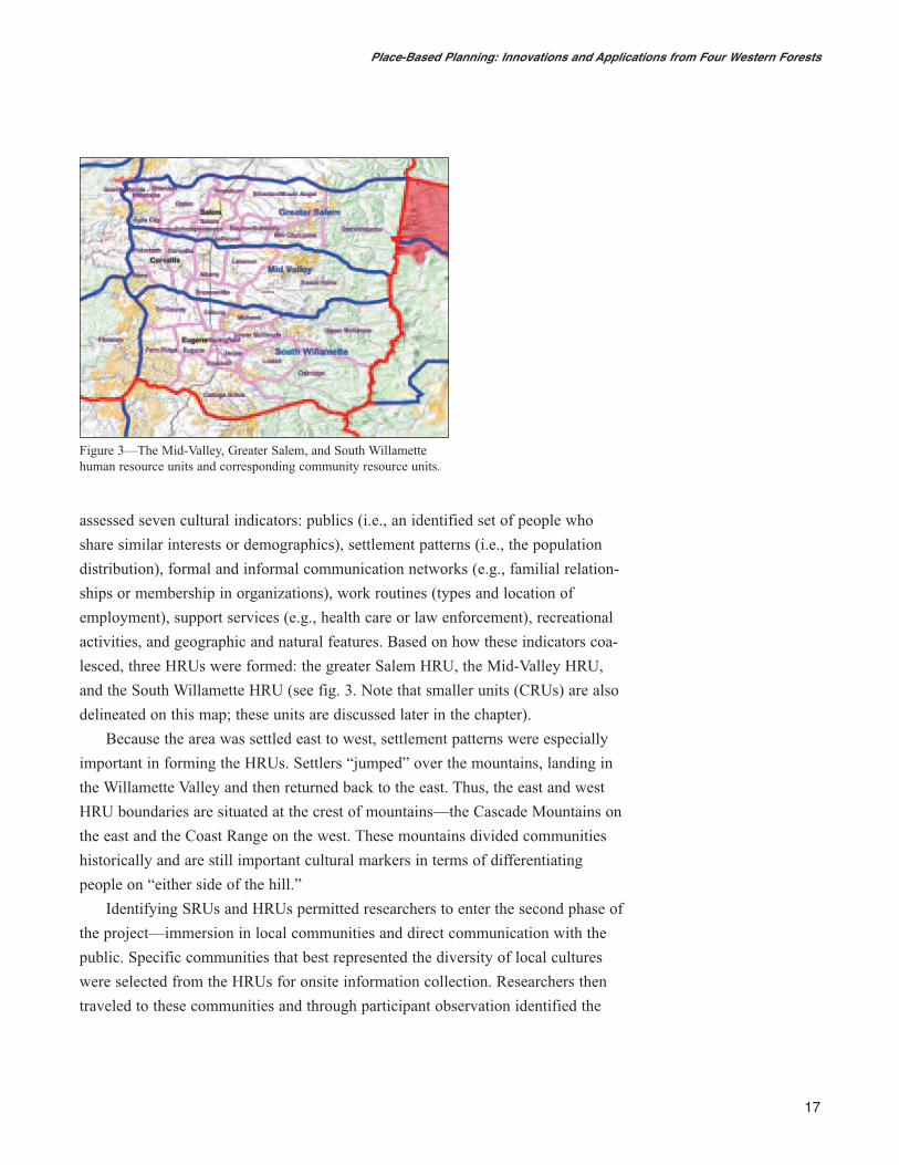
By approaching different types of people in hospitable venues, researchers
were able to account for a large array of stakeholder perspectives. Based on inter-
views, researchers identified common themes and viewpoints shared among com-
munity members as well as domains in which community members had conflicting
opinions. Place meanings, place attachments, and natural resource uses and man-
agement were topics of frequent discussion. Through these discussions, researchers
developed an understanding of person-specific and place-based attributes that
influenced how people thought and felt about the landscape.
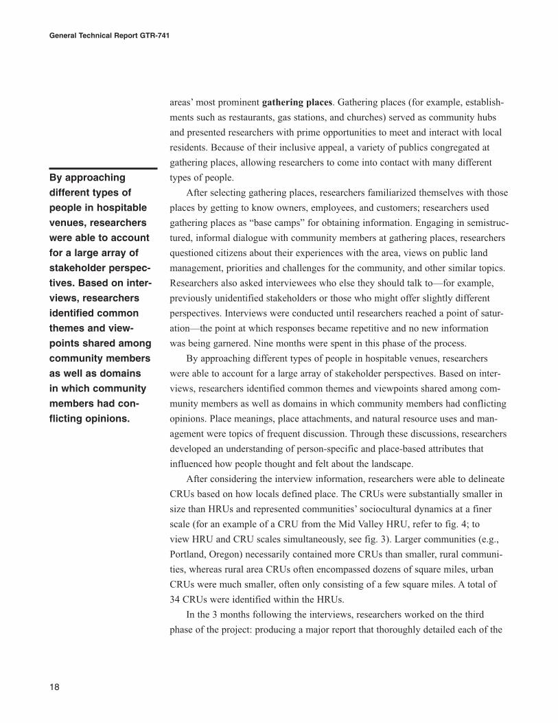
After considering the interview information, researchers were able to delineate
CRUs based on how locals defined place. The CRUs were substantially smaller in
size than HRUs and represented communities’ sociocultural dynamics at a finer
scale (for an example of a CRU from the Mid Valley HRU, refer to fig. 4; to
view HRU and CRU scales simultaneously, see fig. 3). Larger communities (e.g.,
Portland, Oregon) necessarily contained more CRUs than smaller, rural communi-
ties, whereas rural area CRUs often encompassed dozens of square miles, urban
CRUs were much smaller, often only consisting of a few square miles. A total of
34 CRUs were identified within the HRUs.
In the 3 months following the interviews, researchers worked on the third
phase of the project: producing a major report that thoroughly detailed each of the
By approaching
different types of
people in hospitable
venues, researchers
were able to account
for a large array of
stakeholder perspec-
tives. Based on inter-
views, researchers
identified common
themes and view-
points shared among
community members
as well as domains
in which community
members had con-
flicting opinions.
General Technical Report GTR-741
18
SRU’s identified HRUs and CRUs via descriptors such as social and economic
information, details of community life, and natural resources issues.
In addition to the report, a geographic information systems (GIS)-based tool
was developed to complement research findings. The GIS software was used to
overlay various forms of information such as census data, interview results, and
listings of key community members. In this way, CRUs could be queried via the
GIS program and different types of information viewed simultaneously.
Currently, the findings from the Discovery Process have not been formally
integrated into any forest plan revisions or activities. However, the foundation for
implementation remains—high quality data exist that could inform the forest plan
revision. Because a considerable amount of time has elapsed since the original
assessment, performing quick “check ins” with studied communities would be
advisable to update existing information and reinitiate community contacts.
19
Place-Based Planning: Innovations and Applications from Four Western Forests
Figure 4—The Albany-Tangent Community Resource Unit from theMid-Valley.
Benefits and Challenges of Using the WNF’s ApproachOne of the most substantial barriers that arose during the course of this project was
the application of project findings to forest planning. As previously discussed, this
project was not undertaken as an extension of the forest planning process per se but
rather in hopes of taking proactive measures to understand community priorities
and stakeholder assessments of public land management. However, the fact that
this project was not associated with any planning directives has prevented it from
being formally included in forest planning processes. Applying findings to the for-
est plan revision process has also been difficult owing to the transient composition
of leadership teams; many of the project’s original advocates have either retired or
hold different positions within or outside of the agency.
Because this approach adopted an indepth, anthropological orientation to
collecting and analyzing social data, there was some skepticism about whether
findings exemplify “scientific” data. For many, the Discovery Process represented a
paradigmatic shift in problem framing and information gathering, a shift that some
viewed as unnecessary or unwarranted. Although to some skeptics the use of GIS
bolstered the approach’s credibility, there remained doubt as to whether the process
accurately depicted public sentiment. Ironically, though, public meetings—an
accepted method of gaining knowledge about public opinion—tend to breed psy-
chological states (e.g., group polarization, groupthink) that can dilute or misrepre-
sent individuals’ true sentiments. One-on-one discussion may in fact provide less
tainted portrayals of citizens’ opinions.
Originally, a secondary goal of the project had been to train agency personnel
in conducting social assessments (i.e., the Discovery Process). The WNF and other
forests and agencies (e.g., the U.S. Department of the Interior, Bureau of Land
Management) could then continue to self-assess and self-update after the original
project was completed. In this way, the Forest Service and other government agen-
cies could serve as public lands-community liaisons, enabling agencies to have
clearer foresight into community priorities. Because of a variety of factors—some
logistical and some philosophical—this training did not occur beyond the immedi-
ate project.
In terms of benefits of the approach, one prominent benefit is that findings
were based on direct, personal, indepth contact with the public. This degree of
contact provides several distinct advantages. The insight generated through per-
sonal interviews permitted researchers to form a thorough understanding of public
attitudes, beliefs, and behaviors. Rather than relying on standardized, quantitative
data, this qualitative approach enabled participant-driven themes to emerge through
General Technical Report GTR-741
20
honest and direct feedback. For instance, researchers found that—contrary to com-
mon perceptions—many communities, primarily those proximate to the Interstate-
5 corridor, have flourished in their transition from extraction to service-based
economies. Moreover, being able to communicate personally with those involved
in the transition process allowed for greater insight into community dynamics than
could be gleaned through sources such as census data or newspapers.
Personal, one-on-one contact also made the emergence of social and economic
trends easier to trace. Community concerns are constantly in flux and, once docu-
mented, often continue to shift and morph. Conducting face-to-face interviews
provided researchers and planners with an awareness of fluctuations in attitudes
and behaviors as they were happening; the Discovery Process allowed for in-the-
moment assessment of salient public concerns as they were developing and
changing.
Another advantage of this approach was its ability to use GIS to blend multiple
scales and multiple social indicators. By employing this tool, geographic, social,
and economic information were evaluated simultaneously, providing managers and
planners with visual representations of different information types. The GIS tool
also supplied managers with information about key informants for identified
areas;2 CRUs (mapped onto GIS systems) were linked to lists of community mem-
bers who contributed to the assessment. In this way, agencies can track changes in
attitudes and behaviors over time and develop long-term relationships with commu-
nity members.
For more information about the Discovery Process/Willamette National
Forest, contact:
Kevin Preister
Senior Associate
Natural Borders LLC
James Kent Associates
P.O. Box 3493
Ashland, OR 97520
Phone: (541) 488-6978
E-mail: [email protected]
Web site: www.naturalborders.com
Researchers found
that—contrary to
common perceptions
—many communities,
primarily those proxi-
mate to the Interstate-
5 corridor, have flour-
ished in their transi-
tion from extraction
to service-based
economies.
21
Place-Based Planning: Innovations and Applications from Four Western Forests
2 Note that informants must agree to have that information made available.

This page is intentionally left blank.
Chapter 4: The Chugach NationalForestJennifer O. Farnum and Patrick Reed
Overview of the AreaLocated in south-central Alaska, the Chugach National Forest (CNF) is the second
largest national forest in the United States. Over 5.4 million acres (2 185 302 ha) in
size, the CNF surrounds the Gulf of Alaska’s Prince William Sound. Its diverse and
scenic landscapes include temperate rain forest, permanent ice and rock, highly
active tidewater glaciers, and some of North America’s most impressive wetlands.
A number of small towns (e.g., Seward, Valdez, and Cordova) are found in and
adjacent to the CNF. Anchorage, Alaska’s, largest city, is located within an hour’s
travel north along the Seward Highway Scenic Byway.
This northernmost of national forests receives over 625,000 recreational visits
annually. Visitors are attracted to such world-renowned areas as the Copper River
Delta and the Kenai Peninsula. The fjords of Prince William Sound provide some
of the most spectacular landscape and wildlife viewing opportunities that Alaska
has to offer. During the summer months, the CNF is a prime destination for cruise
ships carrying tourists from around the world.
The CNF is 98 percent roadless and accommodates an assortment of recre-
ational opportunities such as kayaking, camping, birding, hiking, cross-country
skiing, and snowmachining. Subsistence activities (e.g., gathering forest products,
fishing, and hunting) are also an important draw for many forest visitors. Similarly,
sport and commercial fishing are highly valued activities on the CNF.
Project RationaleUnlike many national forests, the CNF has managed to avoid major land use
disputes. Commercial timber production and mining activities have become vir-
tually obsolete on the forest, greatly reducing the potential for land use conflicts
that frequently emerge during forest planning.
Residents of surrounding communities value the forest for a wide range of
reasons. Locals, including Anchorage residents, view the CNF as their “backyard”
and demonstrate commendable stewardship activities geared toward maintaining
the CNF’s high-quality state. For example, local environmental groups frequently
distribute materials praising its various qualities. Public support for the forest is so
23
Place-Based Planning: Innovations and Applications from Four Western Forests
great that Alaska state governors have declared “Chugach National Forest Days”
in its honor.
In the late 1990s, the CNF started its forest plan revision. As anticipated, there
was considerable public support for preserving the current condition of the CNF
and, by extension, retaining communities’ quality of life. Accordingly, the main
goal of the research project undertaken on the CNF was to investigate the type of
values the public held for the forest and how proposed management alternatives
might affect those values. To this end, researchers and forest planners aimed to
develop a process that could systematically evaluate the compatibility of manage-
ment alternatives with forest values as identified by the public. Moreover, they
wanted to collect values-based data in such a fashion that the values data could
be easily evaluated alongside biophysical data.
Methods, Techniques, and ParticipantsWorking cooperatively with Alaska Pacific University, researchers administered a
public values survey to a random sample of households in 12 communities adjacent
to the CNF. The sampling frame was drawn from households eligible for the
Alaska Permanent Fund Dividend (PFD), a program that provides Alaska residents
with monies gained from investments purchased with earnings from the state’s oil
industry. Because the vast majority of state residents receive these funds, the PFD
list provides a fairly comprehensive record of Alaska residents.1
The survey investigated the spectrum of values associated with the CNF.
Survey items were based on 13 theory-derived, mutually exclusive value types that
were listed and described on the survey: aesthetic, economic, recreation, learning,
life support, biological diversity, future, subsistence, intrinsic, therapeutic, spiritual,
historic, and cultural. The theory, format, and survey items were peer-reviewed by
a panel of five social scientists, university faculty, and land managers from multiple
agencies. The instrument was then pretested (albeit in a limited fashion) with the
aid of forest staff and university graduate students.
Survey respondents were asked to apply small (1/4-inch diameter), color-
coded, self-adhesive dots on a map of the CNF that was enclosed with survey
materials. Dots were color-coded by value type, indicating the variety and location
of their personal values for the forest.
General Technical Report GTR-741
24
1To qualify for PFD funds, applicants must have lived in the state for 12 months and cannot havebeen out of the state for more than 180 days in a calendar year.
In addition to locating value points, respondents also completed an exercise in
which they indicated the relative importance of different forest values. The survey
presented a hypothetical scenario in which respondents were given $100 to allocate
according to their preferences for the 13 forest value types. The reported dollar fig-
ures represented the value’s relative importance (e.g., assigning $25 to a specific
value would indicate that the value’s importance was 1/4 or 25 percent of all values
reported).
More than 700 households responded (a 32 percent return rate), identifying
over 15,000 value points within the CNF.2 Values information from the returned
surveys was entered into a geographical information system (GIS) database. By
using GIS, researchers and forest planners obtained a general idea about how
values were distributed across the forest. In this way, a visual display of spatial
location of forest values (i.e., a value distribution map) was produced.
After the values distribution mapping, a values suitability analysis (VSA) was
undertaken to examine the relationship between inventoried values and potential
management actions. The VSA consisted of several steps. First, management areas
were overlaid on the CNF map of value distributions. (Management areas had been
identified by the forest’s interdisciplinary team, or IDT, before the current research
took place.) The goal of overlaying management areas with values information was
to permit VSAs to be conducted separately for each management area and for the
forest as a whole.
The second component of the VSA process was to compute a series of “diag-
nostic” statistics including a frequency index, a value density index, a value
diversity index, and a value identity index. Like the values distribution mapping,
frequency and value density indices were intended to provide an overview of how
values were dispersed across the forest. To obtain the frequency index, the number
of value points (i.e., the color-coded dots) within a specific management area was
divided by the average number of points across all management areas. To deter-
mine the per-acre composition of values (i.e., the value density index) the number
of value points in a specific management area was divided by the CNF’s total
landmass.
Value diversity and value identity indices provided finer analyses of forest
values than the frequency and density indices. The value diversity index drew upon
25
Place-Based Planning: Innovations and Applications from Four Western Forests
2 Although low, a 32-percent response rate is not atypical in this type of research. Also, the sample size was small but typical for surveys conducted in Alaska. Followup checks conductedfor nonresponse bias suggested that participants understood the set of questions as they applied to forest plan management decisions.

the Shannon-Weaver diversity index (a tool commonly applied to wildlife and
employment data) and indicated the relative composition of value types within
each management area. Using advanced statistical techniques, a value identity
index was calculated to assess the degree to which the distribution of values within
a given management area is akin to the statistical average of all management areas
considered together.
The third component of the VSA process was to evaluate proposed manage-
ment activities, both individually and in combination with each other as manage-
ment prescriptions. Researchers hoped to tease out whether a proposed manage-
ment activity on the CNF (e.g., road construction) and management prescription
(e.g., resource development) would ultimately be compatible with dominant social
values (e.g., aesthetics). For this part of the process, researchers first looked at
management activities and prescriptions across the CNF without regard to indi-
vidual management areas. In doing so, they obtained a broad sense of activity/
prescription acceptability that then could be refined by management area.
To make judgments regarding the acceptability of activities/prescriptions in
relation to values, a series of matrices were constructed. Matrices required several
computations. If a specific activity was deemed to be compatible with a given
value, the combination received a positively weighted score (i.e., +1); conversely,
if the activity was incompatible, a negatively weighted score (i.e., -1) was given.
A neutral weighting (i.e., “0”) was applied on occasions in which the compatibility
of the activity and the value could not be easily characterized as positive or nega-
tive without more detailed information about how the activity would be carried out
(see table 1).
The next step in completing matrices was to look at the cumulative value
compatibility of each prescription by summing the individual activity compatibility
scores. By summing the scores, each prescription received a total compatibility
score (see table 2). By comparing all prescription scores, it was possible to deter-
mine the relative compatibility of each prescription with each value and to identify
in rank order the best and worst matches of prescriptions and values.
Finally, a similar sequence of calculations was used to compare the com-
patibility of management alternatives—aggregates of management prescriptions—
as applied to management areas and their inventoried distributions of values.
Compatibility scores were tallied, permitting management alternatives to be ranked
for each management area. In this way, various forest plan alternatives were sys-
tematically evaluated in terms of the relationships among individual management
General Technical Report GTR-741
26
activities, combinations of activities as management prescriptions, and combina-
tions of management prescriptions as management alternatives.
An assortment of management alternatives generated by the IDT and public
stakeholder groups were evaluated to see how each alternative meshed with domi-
nant values and the distribution of all values. In sum, a total of 8 management
alternatives were considered, each taking into account the relationships of the 13
value types with 42 activities in 24 management prescriptions across 94 manage-
ment areas.
During a series of public meetings and IDT meetings that included members of
the public, local citizens had an opportunity to validate the project’s assumptions,
findings, and conclusions. Question and answer sessions with the public allowed
for further examination of VSA results through a type of “member’ checking” in
which researchers’ and planners’ understandings of community members’ values
were reviewed. In many cases, explanations of forest values and proposed manage-
ment alternatives made sense to community members; in other cases, presentation
of value-management information led to further debate, reevaluation of original
assumptions regarding values and management alternatives, and greater clarifica-
tion of the nature of value structures.
Once the VSAs were complete, alternatives had been evaluated, and public
validation sought, researchers and planners were able to make specific recommen-
dations to the IDT responsible for overseeing the CNF’s forest plan revision
process. However, most of the findings from the values mapping project were not
27
Place-Based Planning: Innovations and Applications from Four Western Forests
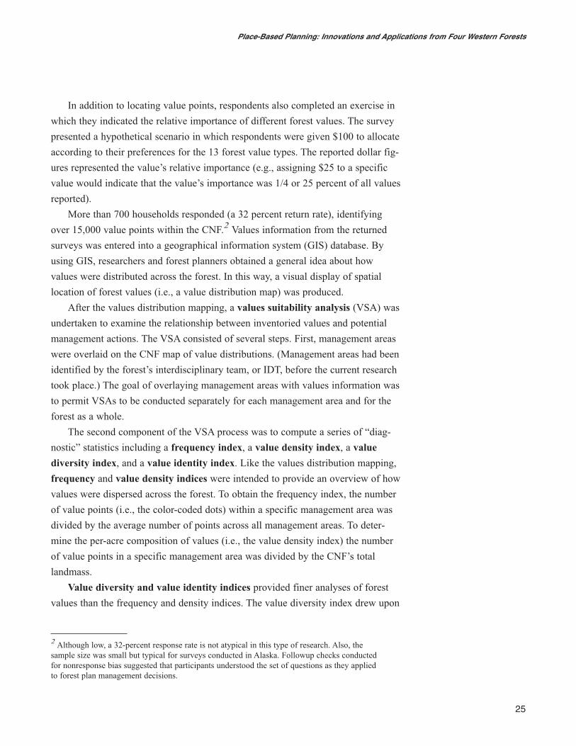
Table 1—Weighting of compatible and incompatible activity-value relationships
Activity-value compatible?Activity allowed? Yes Conditional NoYes 1 0 -1Conditional 0 0 0No -1 0 1
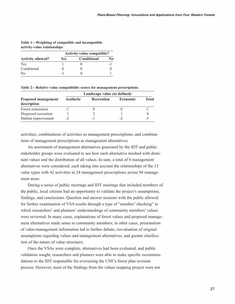
Table 2—Relative value compatibility scores for management prescriptions
Landscape value (as defined)Proposed management Aesthetic Recreation Economic TotaldescriptionForest restoration -1 0 0 -1Dispersed recreation 1 2 1 4Habitat improvement -2 -1 -2 -5
included in the final forest plan revision, which was completed in 2004. The CNF
constructed an interactive Web site that provides detailed information about the
final forest plan revision, the final environmental impact statement, and the record
of decision (see http://maps.fs.fed.us/chugach/).
Benefits and Challenges of Using the CNF’s approachThe most challenging aspects of this project were two-fold: (1) developing a ration-
al and replicable approach for collecting, analyzing, modeling, and reporting social,
value-based information in a spatial context, and (2) integrating what had been
traditionally viewed as qualitative, “soft” science information (i.e., values) into the
forest planning process. The first challenge was the easier of the two because creat-
ing spatially explicit social values information (i.e., using GIS) was a relatively
straightforward exercise that emulated traditional biophysical evaluation tech-
niques.
The latter challenge was more problematic for several reasons. First, using the
values data was perceived to be risky owing to the lack of prior experience with
this type of information. How the public would receive the results was unknown
and the potential legal implications daunting.
Second, promoting interdisciplinary work proved difficult. Researchers’ origi-
nal hope was that because social and biophysical data were presented in a similar
format (i.e., GIS-based), interdisciplinary work would be encouraged— drawing
upon social-biophysical information would become the operating norm for the for-
est planning process. However, despite the fact that the social value data was sound
and emulated the format of biophysical data, there were still barriers to using the
information in forest planning. Specifically, some factions within the IDT viewed
the process as yielding qualitative “soft” information (bordering on anecdotal)
rather than quantitative, “hard” data. The information was viewed as spurious,
unsuitable for consideration in the forest plan revision. Moreover, some perceived
the process as catering to public preferences while ignoring the “true” mandate of
the agency—to manage biophysical resources on a sustainable basis.3
General Technical Report GTR-741
28
3 Social judgments are involved in all aspects of managing biophysical resources including what sustainability entails and what it consists of; ultimately, tapping into people’s value systemsallows insight into sources of conflict, the types of agendas that will arise during forest planning,and how the agency can best meet the public’s needs regardless of whether those needs are mate-rial, psychological, or otherwise.
The fact that there was little literature at the time that supported the metho-
dology behind this assessment technique may have increased the reluctance of
planners unfamiliar with social science to use the information in decisionmaking.
Unfamiliarity may have been exacerbated by the legal ramifications of building
decisions on planning processes that have not been shown to be legally defensible.
Also, because there is no explicit mandate that requires forest plan revisions to
fully incorporate such assessments, using values data may have appeared as an
“extra” or “unnecessary” activity in an already complex and arduous process.
Although the aforementioned challenges made integrating the project’s findings
into the CNF’s forest plan difficult, the approach taken nonetheless possesses many
desirable attributes. It provides a systematic, rational method of incorporating
intangible but important values into land management decisionmaking processes.
Through conducting the analyses described here, social science data can be format-
ted to match data generated in biophysical fields. Arguably, this type of analysis
requires personnel with highly specialized knowledge (e.g., statistics, GIS); ulti-
mately, though, evaluating similar (as opposed to dissimilar) data types may help
increase the comprehensiveness of the forest planning process and encourage
collaborative work.
Another advantage of this approach is that it is able to quantitatively calculate
the diversity of values found in a forest and in specific management areas. In deter-
mining which value types to measure, this approach borrowed from an established
theory that delineates value types (specifically, Rolston and Coufal 1991; see also
Brown 2005 for a more complete description of instrument development). By using
this suite of values, a holistic assessment of value diversity was obtained. Planners
could clearly see the spectrum of values that were associated with various places
and have confidence in the knowledge that the theoretical underpinnings of the
value typology are intact.
Along with the ability to capture a variety of value types comes the additional
benefit of being able to identify areas that may arise as “hotspots,” forest places
that may be or become contentious; areas that possess a diverse set of value types
may be especially important for managers to pay attention to. The value diversity
index can be used to identify places that (for example) scored high on biological
diversity values and also scored high on economic values—value sets that could
produce opposite reactions to management decisions. This tool, then, may help
explain preexisting tension or may alert planners to the possibility of future dis-
putes. Conversely, areas with a low diversity of values and/or a small number of
value points may suggest less potential for controversy.
Along with the ability
to capture a variety of
value types comes the
additional benefit of
being able to identify
areas that may arise
as “hotspots,” forest
places that may be or
become contentious;
areas that possess a
diverse set of value
types may be espe-
cially important for
managers to pay
attention to.
29
Place-Based Planning: Innovations and Applications from Four Western Forests
Another advantage of this approach is that it can generate management alterna-
tives based solely on social values; the VSA can be applied both in a retrospective
fashion to evaluate existing management alternatives and/or in a proactive fashion
to create entirely new alternatives compatible with public values. This departs from
traditional planning processes by permitting (if so desired) reversal of the normal
course of planning events; in many forest planning scenarios, social implications of
management actions have been acknowledged after plan revisions have been struc-
tured around biophysical considerations. The VSA permits the opposite sequencing
of events, constructing plans based on social considerations that in turn may be
evaluated in terms of biophysical criteria.
Lastly, this approach provides greater representativeness of public opinion than
the traditional public meeting formats frequently used to meet “scoping” require-
ments set forth by the 1982 planning rule, which mandates public involvement in
forest planning processes. Experience has repeatedly demonstrated that public
meetings and other such forms of public input are subject to various forms of self-
selection or nonresponse bias. Planners generally do not consider such meetings to
be accurate representations of public opinion; rather, the meetings are viewed as a
way to discover the nature or breadth of issues. By reaching a wider audience, the
type of survey methodology employed by the CNF produces a far more representa-
tive cross section of public attitudes and beliefs than other public scoping activities
that are employed.
Since the original project on the CNF was completed in the late 1990s, the
value assessment approach has been adopted by several prominent organizations
and institutions both in the United States and abroad. For example, the Canadian
Forest Service (CFS) has applied a very similar system of value assessment to
research on the social risks of wildfire. The CFS’s Web-based project allowed com-
munity members to complete value assessments using online maps and materials.
Similarly, the approach has been used in national park planning in Australia.
In addition to being applied in other organizations and locations, this approach
has also been used in scenarios other than forest planning. These include municipal
park planning, scenic highway planning, coastal management, and county-level
planning. The approach’s wide variety of applications across a number of different
geographic places has allowed researchers and planners to assess and validate how
well the approach is working. At present, both of the original project members (see
contact information) are continuing to evaluate and improve the process. In doing
so, they are using multiple indicators to measure technique success and are rigor-
ously documenting progress.
General Technical Report GTR-741
30
For more information about the CNF’s approach, contact:
Patrick Reed
Regional Social Scientist
USDA Forest Service, Region 10
3301 C Street, Suite 202
Anchorage, AK 99503
Phone: (907) 743-9571
Fax: (907) 743-9479
E-mail: [email protected]
Greg Brown
Associate Professor
Recreation and Outdoor Studies Department
Green Mountain College
Poultney, VT 05764
Phone: (802) 287-8330
E-mail: [email protected]
See also:
Brown, G. 2005. Mapping spatial attributes in survey research for natural resource
management: methods and applications. Society and Natural Resources.
18(1): 17–39.
Rolston, H.I.; Coufal, J. 1991. A forest ethic and multivalue forest management.
Journal of Forestry. 89: 35–40.
31
Place-Based Planning: Innovations and Applications from Four Western Forests

This page is intentionally left blank.
Chapter 5: The Grand Mesa,Uncompahgre, andGunnison National ForestsAntony S. Cheng and Carmine Lockwood
Overview of the AreaThe Grand Mesa, Uncompahgre, and Gunnison National Forests (GMUG) include
approximately 3 million acres (1 214 056 ha) of federal public lands in western
Colorado. Encompassing eight counties, the elevation of the GMUG ranges from
a low of 5,800 feet to a high of 14,309 feet (1767 to 4361 meters). A total of 10
wilderness areas are situated within these forests, comprising approximately 19
percent of the GMUG’s total acreage. Six of the Colorado 14ers, iconic mountain
peaks famous for reaching heights of over 14,000 feet, are located on the forests.
A diversity of recreational opportunities are available on the GMUG. Premier
trout streams and lakes are found on the forests; the Grand Mesa alone boasts over
100 lakes and reservoirs. Driving for pleasure, viewing scenery, and hiking are
popular activities. Prime backcountry opportunities exist in places such as the
West Elk Wilderness and the San Juan Mountains. Two world class ski resorts—
Telluride and Crested Butte —attract local, national, and international visitors.
Motorized recreation, too, is popular on the GMUG, especially during the
winter months when snowmobiling becomes a favorite activity. Similarly, off
highway vehicle (OHV) roads and trails are found across the forests.
Project RationaleThe original GMUG forest plan was completed in 1983 and amended in 1991 and
1993. Like many other forest plans in the West, the original plan was heavily influ-
enced by the dominant economic drivers of the era—timber production, livestock
and grazing, and oil and gas exploration and development.
Today, the area’s economic drivers have shifted to health care, retiree services,
and recreation and tourism. This shift has arisen in part due to population growth
and demographic changes in the region; United States census data show that
since the early 1980s, the population of the counties within the GMUG area has
increased by an average of 40 percent. Because of these changes, the GMUG
wanted to approach the forest plan revision process from a fresh angle.
33
Place-Based Planning: Innovations and Applications from Four Western Forests
From the outset of the process, GMUG staff recognized that the traditional degree
of public involvement in planning was insufficient and that stakeholders needed to
be continually involved in forest planning throughout the entirety of the process.
Staff recognized that stakeholders needed to be members of the planning process
throughout its various stages and treated as coauthors in creating the forest plan
revision. This recognition arose in part from work completed for the Uncompahgre
National Forest’s travel management plan, which took a highly collaborative
approach to public involvement. As a result of that process, the GMUG became
more aware of the number, level of activism, and political savvy of stakeholders.
By developing collaborative processes focused on specific places, the GMUG
hoped to address a variety of critical issues. Recreation access, travel management,
wilderness designation, forest health, oil and gas exploration and development, and
timber management activities—all were high profile issues that were continually
emerging on the forests.
Methods, Techniques, and ParticipantsTo provide leadership during the planning process, the GMUG forest planning
team worked with Colorado State University and a third-party neutral facilitator
contracted through the U.S. Institute for Environmental Conflict Resolution. In
addition, district rangers and their staff frequently participated in organizing and
leading public meetings, a partnership that proved critical in maintaining a
“connection to the ground.”
Planners held a series of public workshops to gather information about how
people used the land, how people conceptualized forest places, and the priorities
they had for the forests. To avoid violating the Federal Advisory Committee Act
(FACA), community meetings were well advertised and open to everyone. Meetings
were framed as collaborative learning opportunities, soliciting a diversity of view-
points while identifying areas of common ground.1 As a result, many different
interests were represented at meetings including those of local citizens, members
of national organizations such as Trout Unlimited and the Sierra Club, and repre-
sentatives from energy companies with ties to the area.
To provide a starting point for public meetings, planners divided the forests
into discrete segments that the public could identify with. To this end, the planning
General Technical Report GTR-741
34
1 A full discussion of FACA and its application to forest planning is beyond the scope of thisreport.
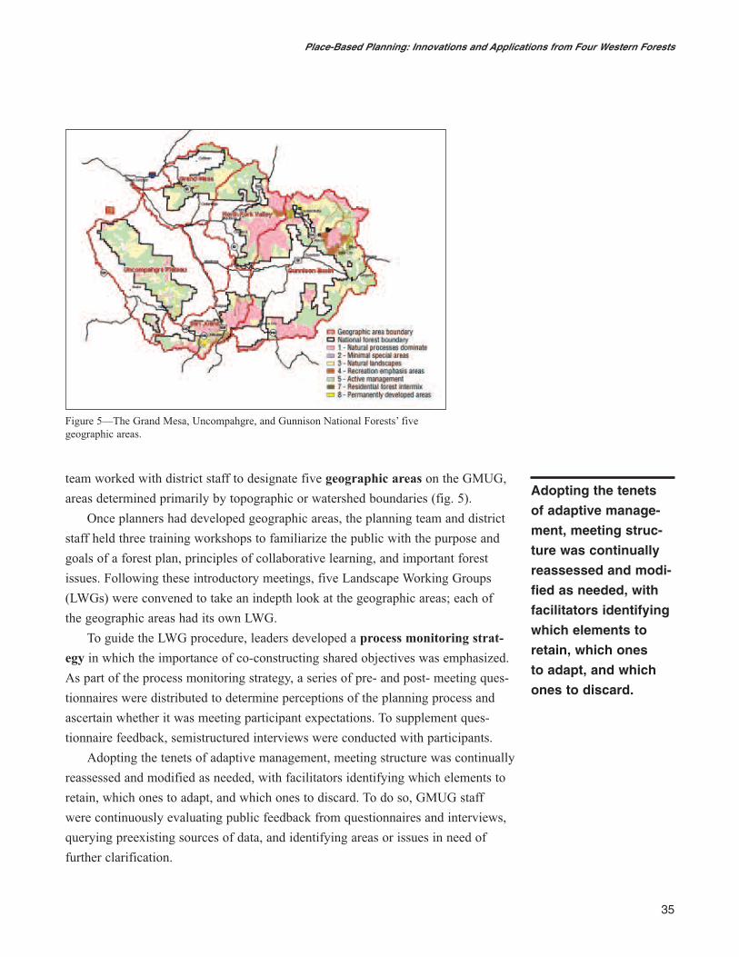
team worked with district staff to designate five geographic areas on the GMUG,
areas determined primarily by topographic or watershed boundaries (fig. 5).
Once planners had developed geographic areas, the planning team and district
staff held three training workshops to familiarize the public with the purpose and
goals of a forest plan, principles of collaborative learning, and important forest
issues. Following these introductory meetings, five Landscape Working Groups
(LWGs) were convened to take an indepth look at the geographic areas; each of
the geographic areas had its own LWG.
To guide the LWG procedure, leaders developed a process monitoring strat-
egy in which the importance of co-constructing shared objectives was emphasized.
As part of the process monitoring strategy, a series of pre- and post- meeting ques-
tionnaires were distributed to determine perceptions of the planning process and
ascertain whether it was meeting participant expectations. To supplement ques-
tionnaire feedback, semistructured interviews were conducted with participants.
Adopting the tenets of adaptive management, meeting structure was continually
reassessed and modified as needed, with facilitators identifying which elements to
retain, which ones to adapt, and which ones to discard. To do so, GMUG staff
were continuously evaluating public feedback from questionnaires and interviews,
querying preexisting sources of data, and identifying areas or issues in need of
further clarification.
Adopting the tenets
of adaptive manage-
ment, meeting struc-
ture was continually
reassessed and modi-
fied as needed, with
facilitators identifying
which elements to
retain, which ones
to adapt, and which
ones to discard.
35
Place-Based Planning: Innovations and Applications from Four Western Forests
Figure 5—The Grand Mesa, Uncompahgre, and Gunnison National Forests’ five geographic areas.
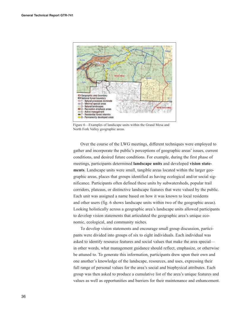
Over the course of the LWG meetings, different techniques were employed to
gather and incorporate the public’s perceptions of geographic areas’ issues, current
conditions, and desired future conditions. For example, during the first phase of
meetings, participants determined landscape units and developed vision state-
ments. Landscape units were small, tangible areas located within the larger geo-
graphic areas, places that groups identified as having ecological and/or social sig-
nificance. Participants often defined these units by subwatersheds, popular trail
corridors, plateaus, or distinctive landscape features that were valued by the public.
Each unit was assigned a name based on how it was known to local residents
and other users (fig. 6 shows landscape units within two of the geographic areas).
Looking holistically across a geographic area’s landscape units allowed participants
to develop vision statements that articulated the geographic area’s unique eco-
nomic, ecological, and community niches.
To develop vision statements and encourage small group discussion, partici-
pants were divided into groups of six to eight individuals. Each individual was
asked to identify resource features and social values that make the area special—
in other words, what management guidance should reflect, emphasize, or otherwise
be attuned to. To generate this information, participants drew upon their own and
one another’s knowledge of the landscape, resources, and uses, expressing their
full range of personal values for the area’s social and biophysical attributes. Each
group was then asked to produce a cumulative list of the area’s unique features and
values as well as opportunities and barriers for their maintenance and enhancement.
General Technical Report GTR-741
36
Figure 6—Examples of landscape units within the Grand Mesa andNorth Fork Valley geographic areas.
Generally, one or two meetings were required to produce vision statements that
could be agreed upon by the group.
During the LWG process, the group also worked on Landscape Management
Themes (LMTs), which had emerged through discussion and debate about desired
conditions and suitable uses. The LMTs ranged from purely natural (i.e., conditions
entirely defined by nature) to permanently developed (i.e., conditions largely
defined by humans, see figs. 5 and 6). Using the LMTs, participants identified their
preferences for desired future conditions and future uses for individual landscape
units within the geographic area. The themes helped people to reflect upon the
character of the area, what they wanted from it, and how the area is currently (and
ideally) being managed.
A variety of worksheets and written materials were available to guide partici-
pants through deliberations, providing them with protocols for discussion (for
examples of the various tools that were used in the visioning and LMT meetings,
go to http://www.fs.fed.us/r2/gmug/policy/plan_rev/collab/guides/index.shtml).
Participants were encouraged to record comments and concerns, thus creating
opportunities for dissenting parties to express their opinions. To aid in this process,
participants were provided with:
• 3- by 5-foot maps of the geographic area divided into smaller landscape
units color coded according to landscape theme dominance;
• Descriptive summaries of each landscape unit detailing its social, economic,
and ecological conditions.
In all, 42 LWG meetings were conducted with 1,035 participants.
Following the final meetings, the planning team synthesized information about
geographic areas and landscape units to produce preliminary versions of the pro-
posed forest plan documents, namely the “zoning” framework of desired condi-
tions. As advocated by the 2005 planning rule, these preliminary proposed docu-
ments were then taken back to stakeholders to complete the iterative process of
plan development, review, and adjustment.2
Another product that emerged from the LWGs was the GMUG’s
Comprehensive Evaluation Report. This report represented the amalgamation
of information regarding the forests’ current conditions, trends and risks, desired
future conditions, and recommended management options. Topics covered included
37
Place-Based Planning: Innovations and Applications from Four Western Forests
2 Note that as this report goes to press, the United States District Court in northern Californiaissued an enjoinment against the 2005 planning rule. How this may affect the course of theGMUG plan and other forest planning processes is uncertain.
vegetation types, number of roads and trails, recreation opportunities, potential for
timber and other resource production activities, and ecological and social values.
The draft version of the report was shared with the public and was further modified
based on their feedback.
Although the GMUG’s approach was well planned and well received by the
public, the current status of the planning process outcome is uncertain. Drawing
heavily upon the LWG findings, a draft revised plan was completed in summer
2006. However, it was not officially released to the public because it was withheld
by the Washington office of the U.S. Department of Agriculture, Forest Service so
that its compliance with the Energy Policy Act of 2005 and the 2005 planning rule
could be better addressed (http://www.fs.fed.us/r2/gmug/policy/plan_rev/
draft/index.shtml).
After the comments of the Washington review were incorporated, a second
draft plan was released in March 2007. However, due to the ongoing legal compli-
cations associated with the 2005 planning rule, the draft plan has been suspended,
and no additional public involvement work is occurring. Participants in the LWGs
are anxious to learn if and how the momentum and successes of these early collab-
orative efforts might be recaptured once the planning proceeds under a newly
approved national rule.
Benefits and Challenges of Using the GMUG’s ApproachThe place-based approach used on the GMUG was a highly deliberative process
requiring integration of individual visions for how the GMUG should look in the
future and consideration of people’s roles in achieving that vision. Diverse individ-
uals were encouraged to confront their differences, weigh relevant technical infor-
mation about environmental conditions, consider the spectrum of landscape values,
and develop vision statements that reflected the majority of their desires for the
future management of the GMUG.
As far as barriers to the approach, four factors were most daunting. First, the
LWGs were open-invitation forums. Therefore, participants and participation were
somewhat variable from one meeting to the next. At times, this made continuity
between meetings challenging. However, the presence of core participants—mem-
bers of the public who regularly attended meetings from the beginning to the end
of the process—helped to maintain consistency and bring new members up to
speed on meeting history, direction, and events.
General Technical Report GTR-741
38
Second, the open-invitation policy employed in this approach—a policy essen-
tial to gathering diversity of views and creating a high degree of group synergy—
inevitably attracted individuals who wanted to focus on a narrow agenda. Forest
planning is essentially strategic planning, which precludes focusing on specific
projects and issues. Some of the participants attended meetings to discuss specific
projects and issues, not to concentrate on broader themes such as current and
desired forest conditions. Keeping meetings centered on broader themes required
ongoing vigilance.
Third, some participants lacked the knowledge necessary to focus on geo-
graphic areas and landscape units. Place-based planning relies on a certain level of
spatial understanding and experience with a forest. Occasional visitors to the area
would not necessarily possess this understanding but may still care deeply about its
future. Thus, it was difficult to integrate the concerns of those who were invested
in the GMUG but who did not have explicit knowledge of forest places.
Lastly, the budget and administrative realities facing the GMUG forest plan
revision were constantly shifting. Ideally, more meetings should have been held
with LWGs to complete the LMT exercises. Similarly, drafting the Comprehensive
Evaluation Report took more time and effort than anticipated. Other issues such
as wildfire mitigation and fuels treatment took priority over forest plan revision,
diverting resources and attention away from planning efforts.
Four factors maximized the utility of this approach. The first was the upfront
time devoted to preparation and planning. Cooperative arrangements among the
GMUG, U.S. Institute for Environmental Conflict Resolution, and Colorado State
University provided GMUG staff with additional skills and resources to design,
implement, and effectively oversee the approach.
Second, the process monitoring and adaptive management strategies of the
LWG process were crucial to making progress and not getting weighed down by
unrealistic expectations or regulations. The resources invested in developing and
implementing these strategies was worthwhile.
Third, the LWGs were able to provide substantive information to the GMUG
planning team that assisted them in producing the final draft plan. Participants and
planners gained a tremendous amount of knowledge about the GMUG’s ecological
and social landscapes. During the LWG process, participants were able to discover
common ground and minimize conflicts over perceived differences. Members of
the public were often surprised at how many similarities existed among themselves,
other participants, and agency representatives.
39
Place-Based Planning: Innovations and Applications from Four Western Forests
Lastly, involving the ranger districts throughout the various phases of the
process was vital. Of the USFS staff, ranger district staff are closest to the ground
and to local people who care about and use the forest. Districts often develop
strong relationships with communities, so having district staff at the meetings pro-
vided a degree of legitimacy and credibility in the eyes of community participants.
For more information about the GMUG’s approach, contact:
Carmine Lockwood
Forest Planning Staff Officer
Grand Mesa, Uncompahgre, & Gunnison National Forests
2250 Highway 50
Delta, CO 81416
Phone: (970) 874-6677
Fax: (970) 874-6698
E-mail: [email protected]
Kathleen Bond
Neutral Facilitator
Kathleen Bond Associates
57730 Herman Road
Olathe, CO 81425
Phone: (970) 323-6577
E-mail: [email protected]
Involving the ranger
districts throughout
the various phases of
the process was vital.
Having district staff at
the meetings provided
a degree of legitimacy
and credibility in the
eyes of community
participants.
General Technical Report GTR-741
40
Chapter 6: ConclusionJennifer O. Farnum and Linda E. Kruger
We commend the researchers and forest staff who participated in developing these
novel approaches to forest planning. They succeeded in finding methods of making
a complicated process meaningful and relevant to the most important stakeholder in
land management—the public. Across the case examples, an array of useful infor-
mation was gathered, including information about the values and meanings people
associated with discrete forest areas, insight into the cultural functioning of local
communities, and visions for how specific areas should be managed.
Despite the ingenuity of these approaches, several practical considerations
require further review and discussion. One such consideration is that place-based
planning is most applicable within local contexts rather than national or even
regional contexts. As noted in the GMUG case example, place-based planning
requires a certain level of knowledge about an area, knowledge generally held by
those who live, work, or recreate close to the area. Public lands, however, belong to
the public at large; although locals may be differentially affected by forest policies,
they are only one of many stakeholder groups that may be invested in the area and
its policies. Indeed, during the appeal phase of a plan or project, national affinity
groups often begin to assert their interests in the area, interests that may have little
to do with specific places per se and more to do with (for example) the symbolic or
existence value of a place. Debates such as those surrounding oil drilling in the
Arctic National Wildlife Refuge highlight the fact that public land decisions can
excite the interest of stakeholders on local, national, and international levels.
Another consideration raised by these examples concerns the Office of
Management and Budget (OMB). Researchers employed by the federal government
are well aware that many mechanisms of communication with the public require
“OMB clearance” or, in other words, adherence to the Paperwork Reduction Act
(PRA) of 1995. The PRA is intended to both minimize the burden placed on the
public during government data collection processes and ensure the quality and
integrity of collected information. Although the PRA was not intended to apply
specifically to the 1982 planning rule (which requires public input in forest plan-
ning processes), there is ambiguity regarding the extent to which the PRA may
pertain to some techniques used in place-based planning. Specifically, PRA regula-
tions clearly stipulate that any survey, interview, or focus group scenario involving
10 or more members of the public must undergo OMB evaluation and authorization
41
Place-Based Planning: Innovations and Applications from Four Western Forests
(see http://www.archives.gov/federal-register/laws/paperwork-reduction/). A full
discussion of how and to what degree OMB considerations may apply in place-
based planning approaches (or forest planning generally) is outside the scope of
this report; however, such considerations should be fully evaluated when planning
for the cost, time, and legal ramifications of employing these and similar
approaches.
An additional hurdle in conducting place-based planning is that such appro-
aches tend to generate a considerable amount of information—even more informa-
tion than traditional planning processes, which are already lengthy and complex
undertakings. Consider the example of the Willamette National Forest: The final
report given to the forest was well organized and well summarized—and based on
a large amount of qualitative data. Without management personnel who are highly
invested in the process and who have access to staff and funding to support the
effort, the amount of accessible information may have been perceived as unman-
ageable. In the case of the Chugach National Forest, too, the agency’s willingness
to implement findings may have been tempered by a high volume of “nonessential”
information. Because social systems are complex and require high levels of moni-
toring and iterative reassessment, investing in place-based planning processes may
seem like an unnecessary use of resources.
Looking at the marginal “success rate” of the four examples, is the amount of
time, effort, and resource expenditure justified? Put another way, is the value-
added through these types of processes worth the cost? At this point in the develop-
ment of place-based planning, those answers are unclear. Research on place-based
planning has (like many grassroots efforts) tended to be spurious, often times lack-
ing the type of scientific rigor that it will take to make valid, substantive decisions
about the strengths and weaknesses of the variety of place-based approaches.
Approaches need more indepth research, research that uses critical, evaluative
methods and employs strict methodological standards. Blending quantitative and
qualitative data collection techniques should also be used to advance a more com-
plete perspective of social and biophysical conditions while cross-validating data
types.
From a planning perspective, concentrating on producing such robust research
may seem superfluous—even daunting—which is why developing planning-
research relationships (e.g., among forests, research stations, and universities) can
be beneficial. Planners gain a better quality product, while researchers are able to
build upon specific examples, cross-pollinating findings and further enhancing the
general fashion in which place-based planning can and should be carried out.
Approaches need
more indepth
research, research
that uses critical,
evaluative methods
and employs strict
methodological stan-
dards. To advance a
more complete per-
spective of social
and biophysical
conditions while
cross-validating
data types.
General Technical Report GTR-741
42
Determining whether place-based planning is a beneficial endeavor for forests
requires evaluation of the social, political, and financial environments within which
each forest is operating. Units that do opt to implement place-based planning in
some form or fashion will benefit from the following suggestions:
1. Develop relationships with researchers. Scientists at research stations,
universities, and private firms may be interested in working with
planners to refine the process and document results.
2. Before planning processes are implemented, seek the advice of planning
team members and those in higher levels of management who will incor-
porate the results into legal documents and sign off on the final plan.
Regardless of the approach’s merit, there will almost always be some
form of dissention; as those in the field of marketing point out, ideas do
not “sell themselves.”
3. Present suggestions for place-based approaches in their formative rather
than finalized stages. Not only does this allow for the inclusion of fresh
material from the project’s inception, but it also ensures that members of
the planning community feel that they were appropriately consulted and
their views were adequately considered. In turn, this raises member
vestedness in the process.
4. Gain support and feedback from members of the larger place-based plan-
ning community. Many involved in the Portland workshop expressed feel-
ings of isolation, of being unaware of others who were conducting similar
work. Networking with like-minded individuals (e.g., through the informa-
tion listed in this publication) can be psychologically reassuring and also
provide direction for planning from start to finish.
In the approaches described in this publication, place-based planning was used
as a mechanism for understanding public values, meanings, and place attachments.
Often times, this resulted in the prioritization of recreation activities, aesthetic
integrity, or existence values. However, there is no inherent aspect of place-based
planning that requires this to be so. Rather, the most useful aspect of place-based
planning may be that it insists that planning occur at scales that have meaning to
the public rather than (for instance) scales based on timber stands. Within these
socially meaningful scales, discussion of priorities can be better framed, regardless
of whether the results of such discussion ultimately champion recreation, extrac-
tion, or other activities or uses. Naturally, there may be occasions when place
“boundaries” that are meaningful to the public will need to be expanded or con-
tracted, particularly when thinking about wildlife corridors, regional planning,
43
Place-Based Planning: Innovations and Applications from Four Western Forests
threatened and endangered species, and other intangible services that are afforded
by public lands. Nevertheless, place-based planning can serve as a tool in recon-
ceptualizing the way that planning units are developed; overlaying values and
“place interest” information side-by-side with other types of data can provide more
nuanced information about management opportunities and challenges.
Despite their potential usefulness in some arenas of public lands planning,
place-based approaches are far from a cure-all for difficulties encountered in plan-
ning processes. Rather, the value-imbibed, meaning-rich information gleaned from
place-based approaches should be treated as one (albeit important) consideration in
planning. Other considerations—wildlife habitat, timber production, water quality,
airsheds, threatened and endangered species, etc.—must continue to be appropri-
ately weighted in successful planning endeavors.
Place-based, collaborative approaches represent necessary and timely alterna-
tives to traditional forest planning processes. With the emergence of value-centered
planning and increasing environmental awareness within the American public,
there seems little possibility that extraction- and production-related priorities will
dominate forest planning processes to the degree they once did. Compared to early
grassroots efforts to make adjustments to forest planning procedures, place-based
approaches have made great strides in terms of both their methodologies and scale.
Employing place-based approaches allows for dialogue to occur at socially mean-
ingful scales, thereby incorporating landscape values and embedded landscape
meanings and taking a necessary step in developing holistic planning approaches
that are truly adaptive.
AcknowledgmentsThis research is part of the Recreation and Tourism Initiative. Funding came
through the Focused Science Delivery Program and The Human and Natural
Resource Interaction Program of the Pacific Northwest Research Station.
The editors would like to thank Antony Cheng for his help in designing and
facilitating the workshop and the workshop participants for sharing their experi-
ences. We also appreciate the effort and aid of the co-authors and the reviewers
who contributed to this publication, Gerard Kyle, Jamia Hansen-Murray, Chris
Hansen-Murray, and Dale Blahna. They were especially helpful in the development
of the “Conclusion” section.
General Technical Report GTR-741
44
Pacific Northwest Research Station
Web site http://www.fs.fed.us/pnwTelephone (503) 808-2592Publication requests (503) 808-2138FAX (503) 808-2130E-mail [email protected] address Publications Distribution
Pacific Northwest Research StationP.O. Box 3890Portland, OR 97208-3890