Embed Size (px)
Citation preview
Plan Prince George’s 2035: Thinking and
Growing Smartly—Downtown and Beyond
Bradley E. Heard
(August 20, 2013)
TABLE OF CONTENTS
INTRODUCTION ...................................................................................... i
EXECUTIVE SUMMARY ..................................................................... iii
REPLACING TIERS WITH PLAN MARYLAND PLACES ................. 1
DEFINING THE PLACE TYPOLOGIES ................................................ 3
Proposed Place Typologies (in descending order of intensity) .......................................................... 4
REDEFINING KONTERRA AND WESTPHALIA ............................... 5
RE-CONCEPTUALIZING THE GENERAL PLAN CORRIDORS ....... 8
Recommended Inner-Beltway Transitways ....................................................................................... 9
Recommended Outer-Beltway Transitways .................................................................................... 11
INCENTIVIZING PRIVATE SECTOR DEVELOPMENT .................. 11
Brief Overview of Station Infrastructure Investment Needs ........................................................... 12
Leveraging the TOD Opportunities at Capitol Heights and Addison Road ..................................... 14
Suggested Prioritization of TOD Resources .................................................................................... 18
PLANNING FOR FUTURE CONNECTIVITY AND CAPACITY ..... 19
Copyright © 2013 by Bradley E. Heard. This work is licensed under the Creative Commons Attribution-NonCommercial-
NoDerivs 3.0 United States License. To view a copy of this license, visit http://creativecommons.org/licenses/by-nc-nd/3.0/us/.
Page i of vi
Plan Prince George’s 2035: Thinking and
Growing Smartly—Downtown and Beyond
INTRODUCTION
This policy paper is an outgrowth of a Town Meeting on June 15, 2013, hosted by the Prince
George’s County Planning Department of the Maryland-National Capital Park and Planning Commission (M-NCPPC) as the public kickoff of Plan Prince George’s 2035, the county’s roughly
decennial update of its General Plan. The question posed at that forum and in the run-up thereto was,
“Where is downtown Prince George’s County?” That question was premised upon the project
team’s preliminary recommendation that the county should identify two or three of its 15 Metro
stations as Priority Investment Districts (PIDs), which the project team defines as “growth areas
selected for long-term, strategic, and coordinated application of public resources, public
infrastructure, and incentives to catalyze business and job creation, a diversification of housing
options, and private investment.” The project team explained its recommendations with respect to
PIDs and prioritization in two primary policy papers: Where and How We Grow (January 24, 2013)
and Typology and Prioritization (March 23, 2013).
The project team’s initial analysis identified six potential downtown stations as possible
PIDs: Prince George’s Plaza, College Park, and New Carrollton (the “high performers”), and Largo
Town Center, Greenbelt, and Branch Avenue (the “game changers”). Of those six, the majority of the
Town Meeting participants, including the author, identified New Carrollton and Largo Town Center
as their preferred choices in the two categories. In a separate survey query, participants also rated
College Park and Prince George’s Plaza highly, along with Largo Town Center and New Carrollton,
as the stations best primed to become a real downtown for the county.
While the question “Where is downtown Prince George’s County?” is important, it is
probably among the easiest decisions the county must make as it updates the General Plan. Indeed,
as the Town Meeting participants’ survey results reflect, there is general consensus that New
Carrollton and Largo Town Center are best poised to be “downtowns” (which this paper calls
“Central Business Districts”). College Park and Prince George’s Plaza and, to a lesser extent,
Greenbelt and Branch Avenue, are also strong contenders for future concentrated business activity.
New Carrollton and College Park are already proposed to be connected with two of Montgomery
County’s CBDs (Bethesda and Silver Spring) by the planned MTA Purple Line. This policy paper
recommends that the Purple Line be extended to connect Largo Town Center and Branch Avenue,
and that the county seat eventually be moved to Largo.
Moving beyond the limited focus of where downtown Prince George’s is or should be, this
paper seeks to delve more fully into the questions posed by the M-NCPPC project team’s two policy
papers: where and how should we grow, and how should our transit stations interact with each other
to form a coherent growth strategy? To reach those threshold questions, this policy paper explores a
number of issues that respond to, expound upon, and in some instances, challenge and propose
revisions to some of the project team’s preliminary policy recommendations. More particularly, this
work addresses the following topics:
Page ii of vi
How should the county classify its land areas to better coincide with the goals of encouraging
transit-oriented development, fostering neighborhood revitalization in our existing
communities, and preserving undisturbed and undeveloped land away from transit?
How should the county characterize the different types of growth and revitalization areas that
are available to support the region’s growth needs, and how should it ensure that these areas
are developed at the intensities that will support heavy rail, light rail, or primary bus line
transit?
How should the county effectively redirect massive suburban and rural expansion projects
like Konterra and Westphalia, which severely threaten the county’s ability to effectively
implement a transit-oriented growth strategy now and in the future?
How should the county redesign its General Plan corridors so that they are focused on
moving people within the county, via transit, rather than through the county, via automobile?
What steps should the county take to incentivize private sector transit-oriented development,
and should its TOD efforts be directed solely toward certain identified “downtown” station
areas, to the exclusion of other transit areas?
The Plan Prince George’s 2035 project team has done an impressive amount of work over the
past year, prior to and since the time that this General Plan amendment process was formally initiated
on January 22, 2013. Now that this project has reached the public engagement phase, it is the
responsibility of concerned citizens to take an active role in the process—to learn about, reflect upon,
and give thoughtful feedback with respect to the project team’s commendable efforts thus far. The
public’s input is vital to the comprehensive planning process, particularly as it relates to countywide
planning.
It is the author’s hope that this policy paper will be a substantial contribution to the public
input process, infusing the marketplace of ideas with serious-minded proposals that will assist the
professional planning staff with making needed revisions and/or refinements to the initial draft of the
General Plan Update, which is due to be released in the fall of 2013.
Page iii of vi
EXECUTIVE SUMMARY
REPLACING TIERS WITH PLAN MARYLAND PLACES
The Plan Prince George’s project team determined that, instead of the vague and confusing
three-tier system used to categorize land in the 2002 General Plan (i.e., “Developed,”
“Developing,” and “Rural”), they would implement the place category guidelines developed
by the Maryland Department of Planning in connection with PlanMaryland, the statewide
development plan, by recategorizing land into one of five place categories: (1) Targeted
Growth and Revitalization Areas; (2) Established Community Areas in Priority Funding
Areas; (3) Future Growth Areas; (4) Large Lot Development Areas; and (5) Rural Resource
Planning Areas.
This policy paper recommends that Targeted Growth and Revitalization Areas be limited to
the ½-mile radius around existing Metro and MARC rail stations; designated ½-mile districts
along General Plan-designated Transitways; and transit-accessible areas within designated
Maryland Sustainable Communities and Maryland Enterprise Zones. Future Growth Areas
should be declared for planned Purple Line and county light rail stations.
This paper recommends that Targeted Growth and Revitalization Areas be developed under
the form-based zoning requirements of Subtitle 27A, which should be renamed the “Urban
Mixed-Use Districts Development Code.” If Subtitle 27A is not used, such areas should be
developed pursuant to the Development District Overlay Zoning (DDOZ) provisions of the
Zoning Ordinance, in conjunction with the following zones: Mixed-Use Infill (M-U-I),
Reserved Open Space (R-O-S), Open Space (O-S), Residential-Infill (R-35), Light Industrial
(I-1), or Heavy Industrial (I-2).
DEFINING THE PLACE TYPOLOGIES
The densities outlined in the Typology and Prioritization policy paper are generally too low
to support heavy and light rail, and they don’t distinguish between the ¼ mile core area and
the ¼ to ½ mile edge area of the applicable center typology. The proposed typologies below
recommend increased densities for the core and edge of most station areas and propose a
hierarchy based on relative intensity. While all places will likely not be developed at their
maximum allowable intensities, it is important that they are at least developed at their
minimum intensities, to ensure orderly growth and development and efficient use of land
around transit stations.
The proposed center typologies, in descending order of intensity, are as follows. (The
bracketed typology references correspond to (1) the place types and descriptions found in the
Reconnecting America / Center for Transit Oriented Development publication Station Area
Planning: How to Make Great Transit-Oriented Places (February 2008); (2) the comparable
District of Columbia zone district; and (3) the comparable mixed-use zone under Subtitle
27A of the Prince George’s County Code.)
o Central Business Districts [Urban Centers; C-4; UC-1]: New Carrollton, Largo
Town Center (possible new county seat)
o Major Urban Districts [Suburban Centers; C-3-C; UC-2]: Greenbelt, Prince
George’s Plaza, Morgan Boulevard, Branch Avenue, National Harbor
o Neighborhood Urban Districts [Urban Neighborhoods; C-3-A; UC-3]: West
Hyattsville, Addison Road, Capitol Heights, Southern Avenue
Page iv of vi
o Special Use/Employment Districts [same; C-2-B; UC-3]: College Park–UM,
Suitland, Oxon Hill
o Transitway Districts [Mixed-Use Corridor; C-2-A; UC-4]: Cheverly, Landover,
and Naylor Road Metrorail stations; all MARC stations (i.e., Bowie State, Seabrook,
Muirkirk, and Riverdale); future Purple Line and county light rail stations; and
specific locations along General Plan-designated Transitways, as determined in
master or sector plans.
REDEFINING KONTERRA AND WESTPHALIA
If the county wishes to be true to its goal of concentrating development around transit and
preserving vital natural resources, it must rethink—and rezone—the proposed massive
greenfield developments at Konterra and Westphalia while there is still time. Failing to do so
will critically endanger the county’s effective implementation of a transit-oriented growth
strategy.
Konterra is within 2 miles of the Muirkirk MARC station and less than 5 miles from
Greenbelt Metro Station. Westphalia is within 5 miles of 6 nearly empty Metro stations, as
well as two proposed Transitway Districts (Woodmore Towne Center and Landover Mall).
The planned massive mixed-use development at Westphalia would blunt development at
those Metro stations and Transitway Districts.
Both sites are outside of the Beltway and not in a Priority Funding Area, Enterprise Zone, or
Sustainable Community. Therefore, they should be classified as either Large Lot
Development Areas or Rural Resource Planning Areas.
RE-CONCEPTUALIZING THE GENERAL PLAN CORRIDORS
Corridors Transitways
The General Plan Update should redesign the Corridor concept such that it ties in “more
closely to the overall county goals of increasing walkability, capitalizing on public
investment, and connections to transit hubs.”
Transitways are major transit routes that should provide reliable, comfortable, and frequent
connections between major population centers and existing Metrorail stations and/or major
commercial and government centers. Through the master planning process, the county should
designate various Transitway Districts as focus areas for revitalization and intensive infill
development along Transitways. Thirteen inner-Beltway and four outer-Beltway Transitways
are recommended.
INCENTIVIZING PRIVATE SECTOR DEVELOPMENT
M-NCPPC’s suggestion of focusing the bulk of the county’s attention on a limited number of
Metro stations—dubbed Priority Investment Districts (PIDs)—makes some sense, but the
focus should not be restricted just to “downtown” stations. A more strategic allocation and a
fairer distribution of government resources are necessary.
Some of the best ways to incentivize private sector development around the PIDs and other
transit station areas actually require little in terms of cash outlay, but they do require
fundamental policy changes, such as:
o Placing appropriate restrictions on further development outside of Targeted Growth
and Revitalization Areas, as outlined herein;
Page v of vi
o Streamlining the development review process (e.g., by increasing use of the form-
based zoning requirements and staff-level review procedures found in Subtitle 27A);
o Simplifying and rewriting the Zoning Ordinance; and
o De-politicizing the development review process by doing away with discretionary
council call-up review
Of the 2 proposed CBD areas, New Carrollton should be the first priority and will require
the most public infrastructure investment to help alleviate some of the poor access issues
resulting from the Amtrak line bisecting the station area. Of the non-CBD areas, Addison
Road and Capitol Heights present the best revitalization opportunity and would benefit most
from public infrastructure investment to help realize their full TOD potential. These are the 3
stations that should be the initial PIDs.
In terms of resource allocation (both financial and time), approximately 40% of the county’s
TOD efforts should be directed toward New Carrollton; 30% should be directed toward
Addison Road and Capitol Heights; 10% should be directed toward marketing and promoting
the prime TOD opportunities available at the other CBD (Largo Town Center) and the Major
Urban Districts; and 20% should be directed toward structural reforms (e.g., effectuating the
countywide rezoning that will implement the revised tier structure discussed herein; revising
and simplifying the zoning ordinance; and de-politicizing the development review process by
eliminating discretionary council call-ups).
PLANNING FOR FUTURE CONNECTIVITY AND CAPACITY
Several proposals for long-range investment in the county’s future are discussed, including:
(1) a Purple Line extension from New Carrollton Station to Eisenhower Avenue Station, on
an inside-the-Beltway alignment via Largo Town Center, FedEx Field, Branch Avenue, and
National Harbor, among other stops; (2) a new MARC train line from Baltimore Penn Station
to La Plata, via BWI-Thurgood Marhsall Airport, Upper Marlboro and Brandywine; (3) a
new county light rail line from Branch Avenue Station to Brandywine; and (4) a new county
light rail line from Southern Avenue Station to National Harbor.
Additionally, a recommendation is included to relocate the county seat to Largo, and to
redevelop the Upper Marlboro area into a more robust Transitway District once the new
MARC line to La Plata is established.

Page vi of vi
Page 1 of 21
Plan Prince George’s 2035: Thinking and
Growing Smartly—Downtown and Beyond
REPLACING TIERS WITH PLAN MARYLAND PLACES
In the Where and How We Grow policy paper, the project team suggested “renaming the tiers
in order to better clarify the expected development pattern for each tier.” Subsequently, the project
team determined that they would implement the guidelines developed by the Maryland Department
of Planning in connection with PlanMaryland, the statewide development plan, by recategorizing
land into one of five place categories: (1) Targeted Growth and Revitalization Areas; (2) Established
Community Areas in Priority Funding Areas; (3) Future Growth Areas; (4) Large Lot Development
Areas; and (5) Rural Resource Planning Areas. Below are some recommendations for how to
designate county land:
Targeted Growth and Revitalization Areas should be limited to:
o Areas within a ½-mile radius1 of:
The main entrance to an existing WMATA or MARC rail transit station;
The transit stop for a designated Transitway District; or
o Maryland Enterprise Zones and Maryland Sustainable Communities in the county.
Future Growth Areas should be limited to:
o Planned MTA Purple Line light rail stations; or
o Planned county light rail stations
Established Community Areas in Priority Funding Areas should be designated for any
remaining land area in a Priority Funding Area (PFA) that is not designated as a Targeted
Growth and Revitalization Area or a Future Growth Area.
Large Lot Development Areas should be limited to any existing recorded subdivision block
or unrecorded parcel outside of a Priority Funding Area that is more than 50% developed at
the intensity that would be allowed in the Residential-Estate (R-E) Zone (i.e., 1.08 DU/Ac
and 0.2 FAR).
Rural Resource Planning Areas should be designated for all remaining land outside of a
Priority Funding Area that is not designated as a Large Lot Development Area, including any
existing recorded subdivision block or unrecorded parcel that is less than 50% developed at
1 The half-mile radius, which translates to a 10-minute walk for the average person, appears to be the
planning industry standard for predicting transit ridership and prescribing land use policy relating to TOD.
Generally, the quarter-mile radius is used to develop land use policies relating to employment around stations, while
the half-mile radius is used when looking at population. (See R. Guerra, R. Cervero, and D. Tischler, The Half-Mile
Circle: Does It Best Represent Transit Station Catchments? (Working Paper, July 2011), published in
Transportation Research Record: Journal of the Transportation Research Board, Vol. 2276, pp. 101-09 (2012)).
Research collected by the Fairfax County Planning Commission’s TOD Committee finds that the optimal walking
distance for TODs is often less than ½-mile—generally around 1,500 feet, or 0.28 miles.
Page 2 of 21
the intensity that would be allowed in the Residential-Estate (R-E) Zone (i.e., 1.08 DU/Ac
and 0.2 FAR).
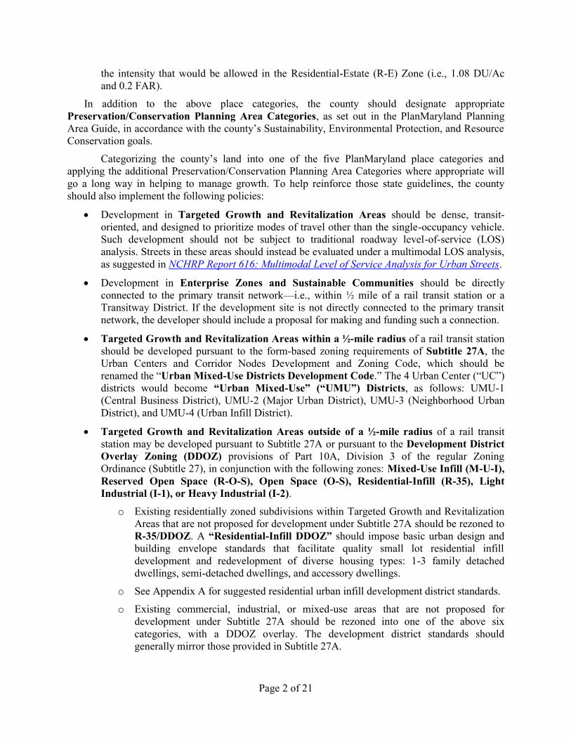
In addition to the above place categories, the county should designate appropriate
Preservation/Conservation Planning Area Categories, as set out in the PlanMaryland Planning
Area Guide, in accordance with the county’s Sustainability, Environmental Protection, and Resource
Conservation goals.
Categorizing the county’s land into one of the five PlanMaryland place categories and
applying the additional Preservation/Conservation Planning Area Categories where appropriate will
go a long way in helping to manage growth. To help reinforce those state guidelines, the county
should also implement the following policies:
Development in Targeted Growth and Revitalization Areas should be dense, transit-
oriented, and designed to prioritize modes of travel other than the single-occupancy vehicle.
Such development should not be subject to traditional roadway level-of-service (LOS)
analysis. Streets in these areas should instead be evaluated under a multimodal LOS analysis,
as suggested in NCHRP Report 616: Multimodal Level of Service Analysis for Urban Streets.
Development in Enterprise Zones and Sustainable Communities should be directly
connected to the primary transit network—i.e., within ½ mile of a rail transit station or a
Transitway District. If the development site is not directly connected to the primary transit
network, the developer should include a proposal for making and funding such a connection.
Targeted Growth and Revitalization Areas within a ½-mile radius of a rail transit station
should be developed pursuant to the form-based zoning requirements of Subtitle 27A, the
Urban Centers and Corridor Nodes Development and Zoning Code, which should be
renamed the “Urban Mixed-Use Districts Development Code.” The 4 Urban Center (“UC”)
districts would become “Urban Mixed-Use” (“UMU”) Districts, as follows: UMU-1
(Central Business District), UMU-2 (Major Urban District), UMU-3 (Neighborhood Urban
District), and UMU-4 (Urban Infill District).
Targeted Growth and Revitalization Areas outside of a ½-mile radius of a rail transit
station may be developed pursuant to Subtitle 27A or pursuant to the Development District
Overlay Zoning (DDOZ) provisions of Part 10A, Division 3 of the regular Zoning
Ordinance (Subtitle 27), in conjunction with the following zones: Mixed-Use Infill (M-U-I),
Reserved Open Space (R-O-S), Open Space (O-S), Residential-Infill (R-35), Light
Industrial (I-1), or Heavy Industrial (I-2).
o Existing residentially zoned subdivisions within Targeted Growth and Revitalization
Areas that are not proposed for development under Subtitle 27A should be rezoned to
R-35/DDOZ. A “Residential-Infill DDOZ” should impose basic urban design and
building envelope standards that facilitate quality small lot residential infill
development and redevelopment of diverse housing types: 1-3 family detached
dwellings, semi-detached dwellings, and accessory dwellings.
o See Appendix A for suggested residential urban infill development district standards.
o Existing commercial, industrial, or mixed-use areas that are not proposed for
development under Subtitle 27A should be rezoned into one of the above six
categories, with a DDOZ overlay. The development district standards should
generally mirror those provided in Subtitle 27A.
Page 3 of 21
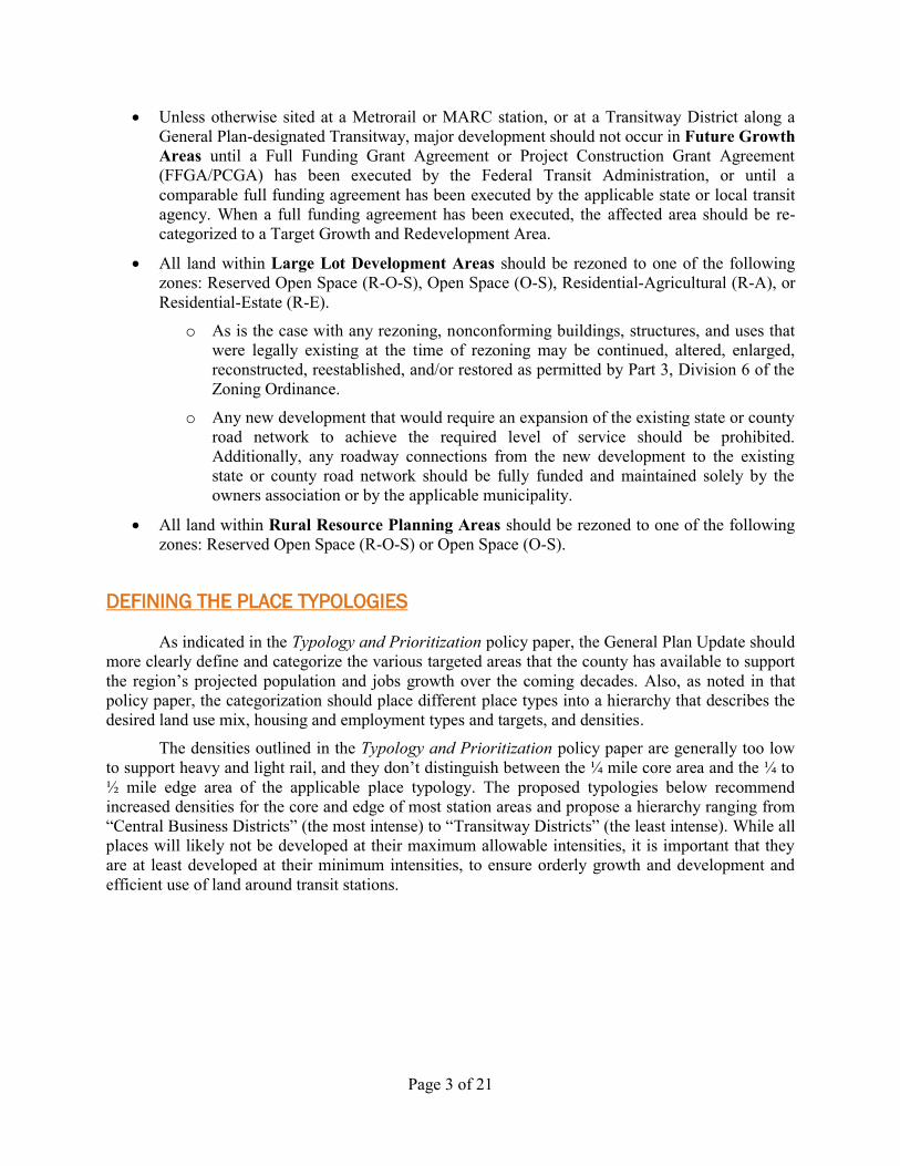
Unless otherwise sited at a Metrorail or MARC station, or at a Transitway District along a
General Plan-designated Transitway, major development should not occur in Future Growth
Areas until a Full Funding Grant Agreement or Project Construction Grant Agreement
(FFGA/PCGA) has been executed by the Federal Transit Administration, or until a
comparable full funding agreement has been executed by the applicable state or local transit
agency. When a full funding agreement has been executed, the affected area should be re-
categorized to a Target Growth and Redevelopment Area.
All land within Large Lot Development Areas should be rezoned to one of the following
zones: Reserved Open Space (R-O-S), Open Space (O-S), Residential-Agricultural (R-A), or
Residential-Estate (R-E).
o As is the case with any rezoning, nonconforming buildings, structures, and uses that
were legally existing at the time of rezoning may be continued, altered, enlarged,
reconstructed, reestablished, and/or restored as permitted by Part 3, Division 6 of the
Zoning Ordinance.
o Any new development that would require an expansion of the existing state or county
road network to achieve the required level of service should be prohibited.
Additionally, any roadway connections from the new development to the existing
state or county road network should be fully funded and maintained solely by the
owners association or by the applicable municipality.
All land within Rural Resource Planning Areas should be rezoned to one of the following
zones: Reserved Open Space (R-O-S) or Open Space (O-S).
DEFINING THE PLACE TYPOLOGIES
As indicated in the Typology and Prioritization policy paper, the General Plan Update should
more clearly define and categorize the various targeted areas that the county has available to support
the region’s projected population and jobs growth over the coming decades. Also, as noted in that
policy paper, the categorization should place different place types into a hierarchy that describes the
desired land use mix, housing and employment types and targets, and densities.
The densities outlined in the Typology and Prioritization policy paper are generally too low
to support heavy and light rail, and they don’t distinguish between the ¼ mile core area and the ¼ to
½ mile edge area of the applicable place typology. The proposed typologies below recommend
increased densities for the core and edge of most station areas and propose a hierarchy ranging from
“Central Business Districts” (the most intense) to “Transitway Districts” (the least intense). While all
places will likely not be developed at their maximum allowable intensities, it is important that they
are at least developed at their minimum intensities, to ensure orderly growth and development and
efficient use of land around transit stations.
Page 4 of 21
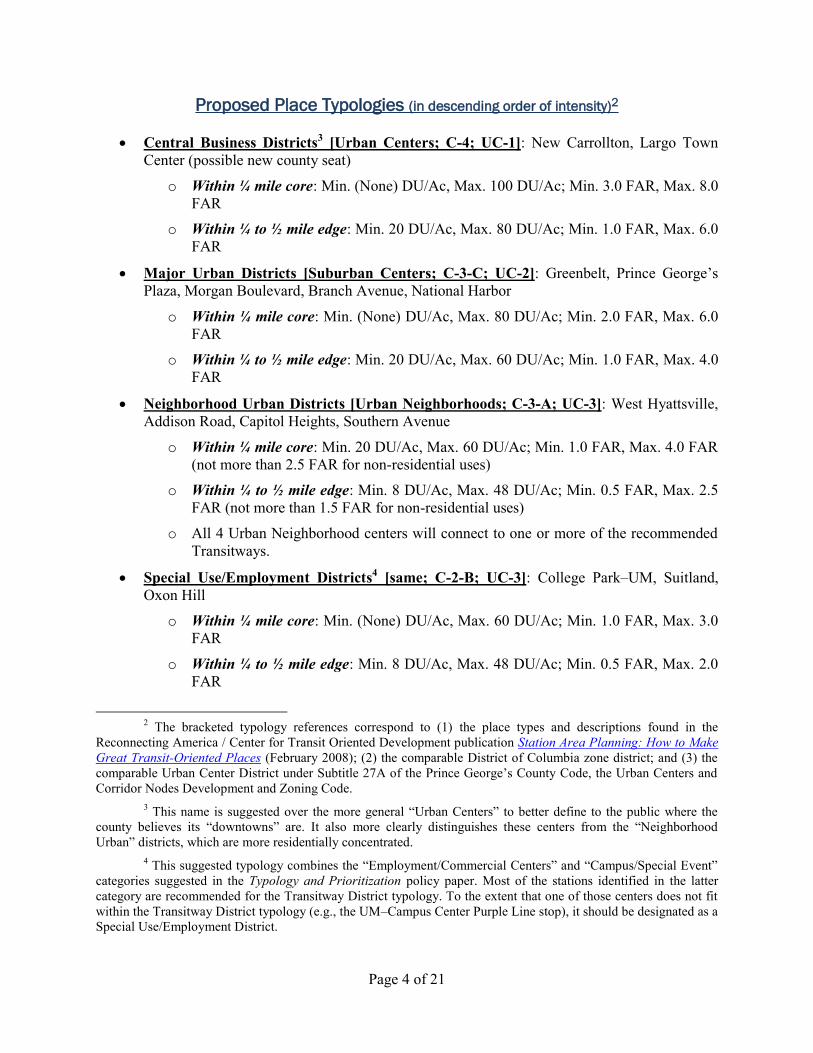
Proposed Place Typologies (in descending order of intensity)2
Central Business Districts3 [Urban Centers; C-4; UC-1]: New Carrollton, Largo Town
Center (possible new county seat)
o Within ¼ mile core: Min. (None) DU/Ac, Max. 100 DU/Ac; Min. 3.0 FAR, Max. 8.0
FAR
o Within ¼ to ½ mile edge: Min. 20 DU/Ac, Max. 80 DU/Ac; Min. 1.0 FAR, Max. 6.0
FAR
Major Urban Districts [Suburban Centers; C-3-C; UC-2]: Greenbelt, Prince George’s
Plaza, Morgan Boulevard, Branch Avenue, National Harbor
o Within ¼ mile core: Min. (None) DU/Ac, Max. 80 DU/Ac; Min. 2.0 FAR, Max. 6.0
FAR
o Within ¼ to ½ mile edge: Min. 20 DU/Ac, Max. 60 DU/Ac; Min. 1.0 FAR, Max. 4.0
FAR
Neighborhood Urban Districts [Urban Neighborhoods; C-3-A; UC-3]: West Hyattsville,
Addison Road, Capitol Heights, Southern Avenue
o Within ¼ mile core: Min. 20 DU/Ac, Max. 60 DU/Ac; Min. 1.0 FAR, Max. 4.0 FAR
(not more than 2.5 FAR for non-residential uses)
o Within ¼ to ½ mile edge: Min. 8 DU/Ac, Max. 48 DU/Ac; Min. 0.5 FAR, Max. 2.5
FAR (not more than 1.5 FAR for non-residential uses)
o All 4 Urban Neighborhood centers will connect to one or more of the recommended
Transitways.
Special Use/Employment Districts4 [same; C-2-B; UC-3]: College Park–UM, Suitland,
Oxon Hill
o Within ¼ mile core: Min. (None) DU/Ac, Max. 60 DU/Ac; Min. 1.0 FAR, Max. 3.0
FAR
o Within ¼ to ½ mile edge: Min. 8 DU/Ac, Max. 48 DU/Ac; Min. 0.5 FAR, Max. 2.0
FAR
2 The bracketed typology references correspond to (1) the place types and descriptions found in the
Reconnecting America / Center for Transit Oriented Development publication Station Area Planning: How to Make
Great Transit-Oriented Places (February 2008); (2) the comparable District of Columbia zone district; and (3) the
comparable Urban Center District under Subtitle 27A of the Prince George’s County Code, the Urban Centers and
Corridor Nodes Development and Zoning Code.
3 This name is suggested over the more general “Urban Centers” to better define to the public where the
county believes its “downtowns” are. It also more clearly distinguishes these centers from the “Neighborhood
Urban” districts, which are more residentially concentrated.
4 This suggested typology combines the “Employment/Commercial Centers” and “Campus/Special Event”
categories suggested in the Typology and Prioritization policy paper. Most of the stations identified in the latter
category are recommended for the Transitway District typology. To the extent that one of those centers does not fit
within the Transitway District typology (e.g., the UM–Campus Center Purple Line stop), it should be designated as a
Special Use/Employment District.
Page 5 of 21
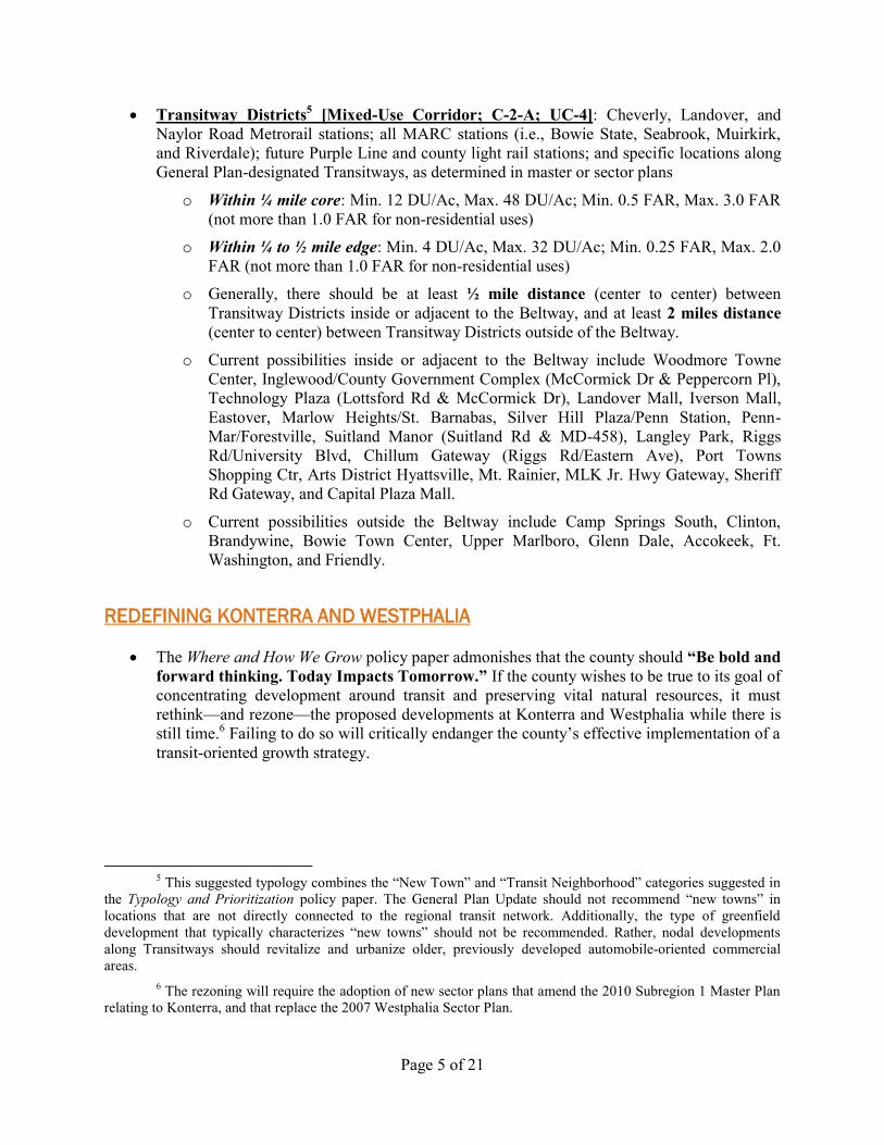
Transitway Districts5 [Mixed-Use Corridor; C-2-A; UC-4]: Cheverly, Landover, and
Naylor Road Metrorail stations; all MARC stations (i.e., Bowie State, Seabrook, Muirkirk,
and Riverdale); future Purple Line and county light rail stations; and specific locations along
General Plan-designated Transitways, as determined in master or sector plans
o Within ¼ mile core: Min. 12 DU/Ac, Max. 48 DU/Ac; Min. 0.5 FAR, Max. 3.0 FAR
(not more than 1.0 FAR for non-residential uses)
o Within ¼ to ½ mile edge: Min. 4 DU/Ac, Max. 32 DU/Ac; Min. 0.25 FAR, Max. 2.0
FAR (not more than 1.0 FAR for non-residential uses)
o Generally, there should be at least ½ mile distance (center to center) between
Transitway Districts inside or adjacent to the Beltway, and at least 2 miles distance
(center to center) between Transitway Districts outside of the Beltway.
o Current possibilities inside or adjacent to the Beltway include Woodmore Towne
Center, Inglewood/County Government Complex (McCormick Dr & Peppercorn Pl),
Technology Plaza (Lottsford Rd & McCormick Dr), Landover Mall, Iverson Mall,
Eastover, Marlow Heights/St. Barnabas, Silver Hill Plaza/Penn Station, Penn-
Mar/Forestville, Suitland Manor (Suitland Rd & MD-458), Langley Park, Riggs
Rd/University Blvd, Chillum Gateway (Riggs Rd/Eastern Ave), Port Towns
Shopping Ctr, Arts District Hyattsville, Mt. Rainier, MLK Jr. Hwy Gateway, Sheriff
Rd Gateway, and Capital Plaza Mall.
o Current possibilities outside the Beltway include Camp Springs South, Clinton,
Brandywine, Bowie Town Center, Upper Marlboro, Glenn Dale, Accokeek, Ft.
Washington, and Friendly.
REDEFINING KONTERRA AND WESTPHALIA
The Where and How We Grow policy paper admonishes that the county should “Be bold and
forward thinking. Today Impacts Tomorrow.” If the county wishes to be true to its goal of
concentrating development around transit and preserving vital natural resources, it must
rethink—and rezone—the proposed developments at Konterra and Westphalia while there is
still time.6 Failing to do so will critically endanger the county’s effective implementation of a
transit-oriented growth strategy.
5 This suggested typology combines the “New Town” and “Transit Neighborhood” categories suggested in
the Typology and Prioritization policy paper. The General Plan Update should not recommend “new towns” in
locations that are not directly connected to the regional transit network. Additionally, the type of greenfield
development that typically characterizes “new towns” should not be recommended. Rather, nodal developments
along Transitways should revitalize and urbanize older, previously developed automobile-oriented commercial
areas.
6 The rezoning will require the adoption of new sector plans that amend the 2010 Subregion 1 Master Plan
relating to Konterra, and that replace the 2007 Westphalia Sector Plan.
Page 6 of 21
The Plan Prince George’s 2035 Project Team’s Tag Line Graphic
The 2,200 acre Konterra property and the 6,000-acre Westphalia property are both
greenfields that are outside of the Beltway and not in a Priority Funding Area, Enterprise
Zone, or Sustainable Community. Therefore, they should be classified as either Large Lot
Development Areas or Rural Resource Planning Areas.
Developing in either of these areas, particularly at the previously contemplated intensities,
would be contrary to the smart growth goals proposed in Envision Prince George’s and in the
Where and How We Grow policy paper, including the goals of directing new development to
transit districts, protecting green space, and avoiding sprawl. Moreover, the proximity of
these developments to existing heavy rail station centers would impede development at those
transit station areas.
o Less than 2 miles away from the Konterra site, The Brick Yard development at the
Muirkirk MARC Station proposes over 1,200 DUs and 700,000 square feet of office
space. Less than 5 miles away, the Greenbelt Station is presently undeveloped. The
488-acre Konterra Town Center East proposal—which recommends an additional
1,500,000 square feet of retail, 3,800,000 square feet of office, 4,500 residential units,
and 600 hotel rooms—would significantly hinder development at the Muirkirk and
Greenbelt centers.
o Westphalia is within 5 miles of 6 Metrorail stations: Largo Town Center, Branch
Avenue, Morgan Boulevard, Addison Road, Capitol Heights, and Suitland. All of
these stations remain significantly underdeveloped or undeveloped. Slightly further
away, Landover Mall, a proposed Transitway District, is also empty; and Woodmore
Towne Center, another proposed Transitway District, has planned development of
1,100,000 square feet of office, 700,000 square feet of retail, 220,000 square feet of
hotel space (410 rooms), and 800 DUs. The proposed 478.5-acre Westphalia Town
Center development—which recommends an additional 4,500,000 square feet of
office, 1,400,000 square feet of retail, 600 hotel rooms, and 5,000 residential units for
this market area—would significantly hinder development at all eight of these
locations.
Page 7 of 21
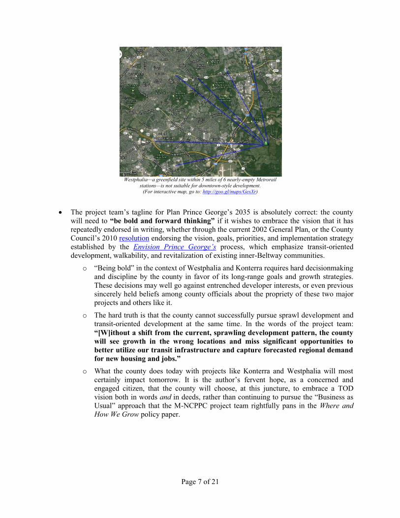
Westphalia—a greenfield site within 5 miles of 6 nearly-empty Metrorail
stations—is not suitable for downtown-style development. (For interactive map, go to: http://goo.gl/maps/GesXr)
The project team’s tagline for Plan Prince George’s 2035 is absolutely correct: the county
will need to “be bold and forward thinking” if it wishes to embrace the vision that it has
repeatedly endorsed in writing, whether through the current 2002 General Plan, or the County
Council’s 2010 resolution endorsing the vision, goals, priorities, and implementation strategy
established by the Envision Prince George’s process, which emphasize transit-oriented
development, walkability, and revitalization of existing inner-Beltway communities.
o “Being bold” in the context of Westphalia and Konterra requires hard decisionmaking
and discipline by the county in favor of its long-range goals and growth strategies.
These decisions may well go against entrenched developer interests, or even previous
sincerely held beliefs among county officials about the propriety of these two major
projects and others like it.
o The hard truth is that the county cannot successfully pursue sprawl development and
transit-oriented development at the same time. In the words of the project team:
“[W]ithout a shift from the current, sprawling development pattern, the county
will see growth in the wrong locations and miss significant opportunities to
better utilize our transit infrastructure and capture forecasted regional demand
for new housing and jobs.”
o What the county does today with projects like Konterra and Westphalia will most
certainly impact tomorrow. It is the author’s fervent hope, as a concerned and
engaged citizen, that the county will choose, at this juncture, to embrace a TOD
vision both in words and in deeds, rather than continuing to pursue the “Business as
Usual” approach that the M-NCPPC project team rightfully pans in the Where and
How We Grow policy paper.
Page 8 of 21
RE-CONCEPTUALIZING THE GENERAL PLAN CORRIDORS
Corridors Transitways
The concept of General Plan Corridors should not be abandoned in the General Plan Update,
as suggested in the Where and How We Grow policy paper. Rather, as noted in that policy
paper, the General Plan Update should redesign the Corridor concept such that it ties in
“more closely to the overall county goals of increasing walkability, capitalizing on public
investment, and connections to transit hubs.”
Transitways should have the following goals:
o To increase the use of public transit by providing reliable, comfortable, and frequent
connections between major population centers and existing rail transit stations and/or
major commercial and government centers.
o To foster the revitalization and redevelopment of aging or deteriorated automobile-
oriented commercial areas by facilitating the construction of mixed-use infill
development that is compact, walkable, and transit-oriented.
o To reduce the negative environmental impacts resulting from the unnecessary and
inefficient use of single-occupancy vehicles.
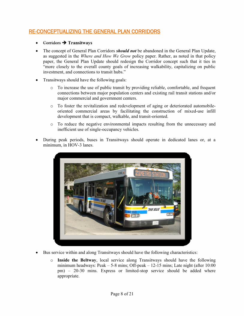
During peak periods, buses in Transitways should operate in dedicated lanes or, at a
minimum, in HOV-3 lanes.
Bus service within and along Transitways should have the following characteristics:
o Inside the Beltway, local service along Transitways should have the following
minimum headways: Peak – 5-8 mins; Off-peak – 12-15 mins; Late night (after 10:00
pm) – 20-30 mins. Express or limited-stop service should be added where
appropriate.
Page 9 of 21
o Outside the Beltway, express service along Transitways should have the following
minimum headways: Peak – 15-30 mins; Off-peak – 30-45 mins; Late night (after
10:00 pm) – 45-60 mins.
o Bus stops should be covered, with seating, lighting, maps and other wayfinding
information, and trash receptacles.
o The pedestrian pathways along and leading to corridor nodes and activity centers
(within at least a ½-mile radius thereof) should be clear and well lit, with complete
and sufficiently wide sidewalks.
The above transit infrastructure and service levels should be fully funded annually in
DPW&T’s CIP and operating budgets and should take precedence over all non-safety-related
transportation expenditures.7
Through the master or sector planning process, the county should designate various existing
automobile-oriented commercial centers as Transitway Districts. These will be focus areas
for revitalization and redevelopment into compact, walkable, and mixed-use urban places.
Over time, when market conditions warrant, high-performing Transitways should be
evaluated for fixed guideway transit (BRT or light rail).
The county should rebrand its transit service so that the same root name (e.g. PGCLink,
LinkPGC, PGCTransit, ConnectPGC) can be used for local and express buses, BRT, and
light rail (e.g. PGCLink Bus, PGCLink Express, PGCLink Rail).
Recommended Inner-Beltway Transitways8
Marlboro Pike/Benning Road/Minnesota Ave: From Marlboro Pike & Forestville Road,
northwest on Marlboro Pike to Benning Road (passing through the Forestville, District
Heights, and Coral Hills commercial districts), then continuing north onto Benning Road NE
to Benning Road and Minnesota Avenue stations.
Addison Road/Suitland/National Harbor: From Addison Road Station, south on Addison
Road South and Walker Mill Rd to MD-458 (Silver Hill Rd), then continuing to Suitland
Metro Station (past the Silver Hill Plaza/Penn Station and Suitland Manor centers), then
continuing southwest to Branch Ave (MD-5) (at Iverson Mall), then continuing southeast to
MD-414 (St. Barnabas Rd) (past the Marlow Heights Shopping Center and commercial
7 Given the limitations imposed by TRIM, the county might not be able to fully fund the transit
infrastructure and levels of service described above, even after eliminating the many discretionary road expansion
projects currently in DPW&T’s operating and CIP budget. In that case, the county should coordinate with its state
legislative delegation to obtain authority from the General Assembly to create a separate public transit authority (the
“Prince George’s County Transit Authority” or “PGCTA”) that would have ability to levy sales and/or property
taxes sufficient to fund a proper locally-owned transit system (LOTS). The transit authority in Austin, Texas, for
example, is 60% funded by a 1-cent sales tax and 7% funded by fare revenue, keeping the service accessible and
affordable to the riding public. To ensure an appropriate level of coordination and cooperation on state, local, and
regional levels, the PGCTA board should include appointees from the MTA, the Maryland Department of Planning,
M-NCPPC, and the county legislative delegation to the General Assembly, as well as from the county executive and
county council. Board members’ terms should be staggered to facilitate institutional knowledge.
8 For an interactive map, go to: http://goo.gl/maps/8RUia
Page 10 of 21
district), then continuing southwest on MD-414 (Oxon Hill Rd) (past the Oxon Hill
commercial district), then continuing southwest and south to National Harbor.
Addison Road/Hill Road/New Carrollton: From Addison Road Station, east on MD-214
(Central Ave) to Hill Rd (at possible future Transitway District), then continuing north and
northwest to MD-704 (MLK Jr. Hwy), then continuing northeast to Ardwick-Ardmore Rd,
then continuing northwest to Pennsy Dr (past industrial park), then continuing north and west
to Corporate Dr and to New Carrolton Station.
Southern Ave/Indian Head Ave/National Harbor: From Southern Ave Station, southwest
on Southern Ave to MD-210 (Indian Head Ave/Hwy), then continuing south to Livingston
Rd (past Eastover Shopping Center), then continuing southeast to Oxon Hill Rd (through
Oxon Hill commercial district), then continuing southwest and south to National Harbor.
Capitol Heights/Chapel Oaks/Deanwood: From Capitol Heights Station, southeast on
MD-214 (Central Ave) to Addison Rd (passing through Addison Plaza Shopping Ctr), then
continuing north and northwest to MD-704 (MLK Jr. Hwy) (passing through Seat Pleasant
municipal center), then continuing northeast to Greig Street (passing through the MLK Jr.
Hwy Gateway commercial district), then continuing west to Addison Rd, then continuing
northwest and west along Addison Road and Minnesota Ave NE to the Deanwood Station
(passing through the Town of Fairmount Heights, the Sheriff Road Gateway commercial
district, and the Chapel Oaks and Deanwood Park neighborhoods).
PGCC/Largo/Woodmore: From PGCC (Campus Way South & Largo Rd/MD-202), west
on Campus Way South to Harry S. Truman Dr, then continuing north to Largo Town Center
Station, then continuing out of station southeast on Largo Dr West to Lottsford Rd, then
continuing north to McCormick Dr (on the west side of the technology office park), then
continuing west and north, across MD-202 (past Inglewood office complex and county
center) to St. Joseph Drive, then continuing northeast to McHugh Drive, then continuing
northwest into Woodmore Towne Center (at Campus Way North).
Largo/Landover Mall/New Carrollton: From Largo Town Center Station, southeast on
Largo Dr West to Lottsford Rd, then continuing north to McCormick Dr (on the west side of
the technology office park), then continuing west and north to MD-202 (Landover Rd) (past
Inglewood office complex and county center), then continuing northwest to Brightseat Rd
and into future main Landover Mall development transit stop, then returning to Brightseat Rd
and continuing north to Glenarden Parkway, then continuing west to MD-704 (MLK Jr.
Hwy) (past the City of Glenarden municipal complex), then continuing northeast to Ardwick-
Ardmore Rd, then continuing northwest to Pennsy Dr (past industrial park), then continuing
north and west to Corporate Dr and to New Carrolton Station.
New Carrollton/Capital Plaza/Arts District: From New Carrollton Station, northwest on
Harkins Rd to MD-450 (Annapolis Rd), then continuing southwest to Baltimore Ave (US-1
Alt) (past Capital Plaza Mall and the Town of Bladensburg), then continuing north onto US-1
(Baltimore Ave) to Arts District Hyattsville (at Jefferson St).
West Hyattsville/Arts District/Port Towns: From West Hyattsville Station, southeast on
MD-208 (Hamilton St) to 38th St, then continuing north and east onto Jefferson St, then
continuing to US-1 (Baltimore Ave) (at Arts District Hyattsville), then continuing southeast
and south on US-1 Alt (Baltimore Ave), then continuing southwest on US-1 Alt
(Bladensburg Rd) to Eastern Ave (past the Port Towns commercial district).
Page 11 of 21
West Hyattsville/Mt. Rainier/Arts District: From West Hyattsville Station, southwest on
MD-500 (Queens Chapel Rd), then continuing southeast and south onto MD-501 (Chillum
Rd) and 34th St to US-1 (Rhode Island Ave) (at the Mt. Rainier roundabout), then continuing
northeast on US-1 (Rhode Island Ave and Baltimore Ave) to Arts District Hyattsville
(Jefferson St).
Langley Park/Greenbelt: From Langley Park Transit Center to Greenbelt Station via
MD-193 (University Blvd).
Langley Park/Ft. Totten: From Langley Park Transit Center to Fort Totten Station via
MD-193 (University Blvd) and MD-212 (Riggs Rd).
Mt. Rainier/Beltsville: US-1 (Rhode Island Ave / Baltimore Ave) from Eastern Ave to
MD-212 (Powder Mill Rd).
Recommended Outer-Beltway Transitways
Brandywine-Clinton,9 connecting at Branch Avenue Station;
Bowie Town Center-Glenn Dale, connecting at Bowie State and New Carrollton stations;10
Accokeek-Ft. Washington-Friendly, connecting at Southern Avenue Station
Upper Marlboro,11 connecting at Largo Town Center Station
INCENTIVIZING PRIVATE SECTOR DEVELOPMENT
The Typology and Prioritization policy paper and the Town Meeting presentation
preliminarily recommended selection of 2 or 3 “downtown” Metro stations as Priority
Investment Districts (PIDs). Those stations would be the focus of county implementation
planning, marketing, infrastructure investment, and incentives to encourage commercial and
retail development by the private sector. Other centers would be focus areas for private sector
residential development and revitalization, but public investment would be limited to
maintaining existing facilities and services, not making new infrastructure investments.
While it makes sense to focus the bulk of the county’s attention at a limited number of station
areas at any one time, the above-suggested approach is perhaps too draconian and short-
sighted to the extent it concentrates solely on “downtown” areas. A more strategic allocation
and a fairer distribution of government resources are necessary.
9 Two Transitway Districts could be created in Brandywine: one near the intersection of Brandywine Rd
and the CSX rail line (which could become a future MARC station), and one that links the Brandywine Crossing
development with the Soil Safe site adjacent to the CSX rail line, which has potential to be redeveloped into a mixed
use community once the current industrial use ceases.
10 Via MD-197 (Collington Rd), MD-564 (Lanham-Severn Rd), and MD-450 (Annapolis Rd). The Glenn
Dale stop would be at Eastgate Shopping Center.
11 The center of this Transitway District would be at MD-725 (Main Street), between the County
Administration Building and the Courthouse.
Page 12 of 21
Some of the best ways to incentivize private sector development around the CBDs and other
place typologies actually require little in terms of cash outlay, but do require the county to
make fundamental policy changes. These include:
o Placing appropriate restrictions on further development outside of Targeted Growth
and Revitalization areas, as outlined herein;
o Streamlining the development review process (e.g., by increasing use of the form-
based zoning requirements and staff-level review procedures found in Subtitle
27A);12
o Simplifying and rewriting the Zoning Ordinance;13 and
o De-politicizing the development review process by doing away with discretionary
council call-up reviews under Subtitle 27A.14
Brief Overview of Station Infrastructure Investment Needs
Of the two proposed CBDs, New Carrollton is the one that will require the most in terms of
public infrastructure investment, given that the station area (and the station itself) is bisected
by the Amtrak rail line. For example, providing partial public financing of multimodal
railway underpasses that connect cars, bicycles, and pedestrians to the northern and southern
sides of the station area would be a wise and likely necessary step that the county should take
in order to woo additional private investment. Additional reconfiguration of the rail station
building and platforms may be required to facilitate traffic flow, including providing a north-
south passageway for the planned Purple Line extension to Largo Town Center and beyond.
Building additional arterial roadways and interchanges around the CBDs should generally be
avoided, inasmuch as both of those centers are already well served by arterial connections.
The same holds true for public financing of excessive amounts of structured parking. The
12
There appears to be an inexplicable reticence among M-NCPPC and the District Council to embrace and
use the comprehensive and innovative mixed-use zoning tool that the county spent several years and hundreds of
thousands of dollars developing. This reticence is certainly not borne out of any empirical evidence gained through
implementing Subtitle 27A, since no station area has ever had a regulating plan in place. Rather, officials suggest
that there is a perception among developers that the prescriptive form-based zoning requirements imposed via the
regulating plan under Subtitle 27A have no upside, because they do not result in any tangible savings of time in the
development review process, since all projects are subject to the same discretionary council call-up review.
However, the solution that logically follows is not to abandon Subtitle 27A. Instead, the Council should revise
Subtitle 27A, as discussed herein, so that plans developed in compliance with a Subtitle 27A regulating plan are not
subject to council call-up.
13 M-NCPPC initiated a comprehensive rewrite of the Zoning Ordinance and the Subdivision Regulations
in 2009, partnering with respected outside legal and technical consultants. The project was well underway, and a
substantial amount of drafting had been completed; however, the effort was aborted in 2010, allegedly for budgetary
reasons.
14 Specifically, the Council should repeal subsection (k) of Section 27A-213 (relating to discretionary call-
up reviews of the Planning Board’s decisions regarding Permit Site Plans) and subsection (c) of Section 27A-214
(relating to discretionary call-up reviews of the Zoning Hearing Examiner’s decisions regarding deviations and
variances). This still leaves the opportunity for interested parties to have a full public adjudicatory hearing before the
Planning Board (when review of a staff-level decision on a permit site plan is desired) or the Zoning Hearing
Examiner (when an applicant desires a deviation or variance from the regulating plan). Any further reviews should
be accomplished through the courts, on a petition for judicial review of an agency’s final decision.
Page 13 of 21
emphasis, after all, should be on transit-oriented development, including making the
locations safer and more inviting for bikers and pedestrians. Committing millions of public
dollars to making these already-automobile-oriented Metro station areas even more
accessible to automobiles, rather than transit riders, misses the whole point of TOD.
The northern Green Line stations (Greenbelt, College Park, Prince George’s Plaza, and West
Hyattsville) are newer station areas that need little in terms of public infrastructure
improvements to entice private sector commercial development. Those station areas are
already essentially development-ready, with ample roadways to serve the areas.
Similarly, the southern Green Line stations (Southern Ave, Naylor Rd, Suitland, and Branch
Ave) and eastern Blue Line stations (Morgan Blvd and Largo Town Center) are newer station
areas where the surrounding developable land is flat and/or cleared, and assembled—owned
either by WMATA, M-NCPPC, the federal government, or a limited number of private
entities. Thus, there is not as much of a need for major county infrastructure improvements in
those station areas.15
TOD opportunities in the Cheverly and Landover station areas on the Orange Line are
significantly limited by the Amtrak rail line, US-50, flood plains, and existing large industrial
uses that surround the stations. The primary developable land at these stations is on the
WMATA-owned parking lots, which are already cleared and accessible. There is not as much
of a need for major county infrastructure improvements or incentives in those station areas.
TOD opportunities at the Suitland Station are significantly limited by MD-337 (Suitland
Pkwy) to the west and by the federal government’s control of most of the land area within the
½-mile station area northwest of MD-458, which it intends to hold for future secure-campus
office buildings. Existing low- to medium-density residential uses occupy much of the land
within the ½-mile station area southeast of MD-458. Suitland does offer a few good TOD
opportunities at the edge and outside of the ½-mile station area.16 These opportunity areas lie
along and within ¼ mile of the proposed Addison Road/Suitland/National Harbor Transitway
and may therefore be suitable for private development as a Transitway District centered at
MD-218 & MD-458. However, there is not a need for major county infrastructure
improvements within the ½-mile Suitland Station area.17
The two first-generation western Blue Line stations near the District of Columbia line—
Capitol Heights and Addison Road—have tremendous urban neighborhood TOD potential
that is different in character than a CBD, but just as vital to the lifeblood of the county. Like
New Carrollton, these station areas will need significant public infrastructure investments to
realize their full potential. The next section discusses these two stations in more detail.
15
Governor O’Malley recently announced that the county will receive $50 million in state funds in FY2014
to improve pedestrian and bicycle access to the Branch Avenue station, which is a welcome development.
16 A deteriorating small commercial strip in the northeast and southeast quadrants of the intersection of
MD-458 (Silver Hill Rd) and MD-218 (Suitland Rd) adjoins another small commercial strip in the northwest
quadrant of that intersection. Behind the northwest commercial strip is 19-acre cleared parcel (formerly Suitland
Manor Apartments), owned by the county Redevelopment Authority. All of these areas are between ½ and ¾ mile of
the station.
17 The county should still include funds within its CIP budget to improve pedestrian connections along
MD-458 for the existing neighborhood residents.
Page 14 of 21
Leveraging the TOD Opportunities at Capitol Heights and Addison Road
There is a vast amount of developable and re-developable land adjacent to and within a ½-
mile radius of the Capitol Heights and Addison Road stations. Additionally, the overlapping
pedestrian sheds created by the two stations within a mile of each other provides a unique
opportunity—unparalleled anywhere else in the county—to develop a thriving, compact,
walkable, and continuous mixed-use neighborhood corridor that is within walking distance to
Metro at all points, similar to the Capitol South–Eastern Market–Potomac Avenue and
Columbia Heights-Georgia Avenue-Petworth neighborhood corridors in Southeast DC.18
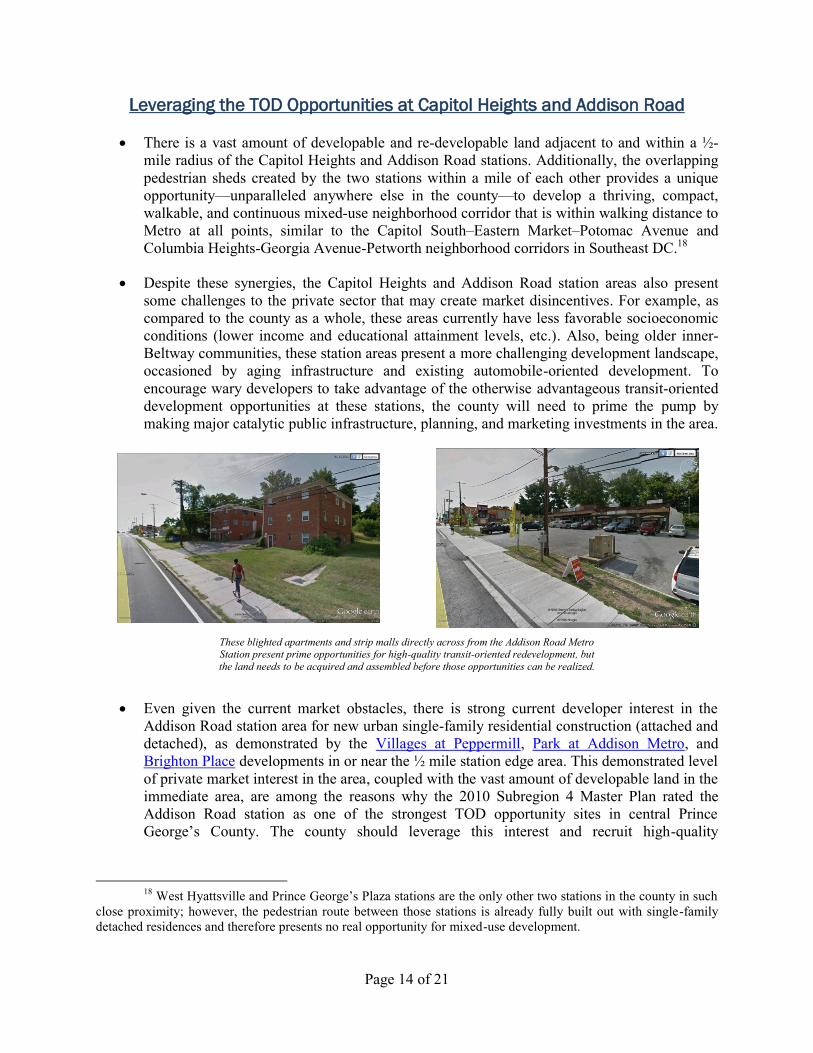
Despite these synergies, the Capitol Heights and Addison Road station areas also present
some challenges to the private sector that may create market disincentives. For example, as
compared to the county as a whole, these areas currently have less favorable socioeconomic
conditions (lower income and educational attainment levels, etc.). Also, being older inner-
Beltway communities, these station areas present a more challenging development landscape,
occasioned by aging infrastructure and existing automobile-oriented development. To
encourage wary developers to take advantage of the otherwise advantageous transit-oriented
development opportunities at these stations, the county will need to prime the pump by
making major catalytic public infrastructure, planning, and marketing investments in the area.
These blighted apartments and strip malls directly across from the Addison Road Metro Station present prime opportunities for high-quality transit-oriented redevelopment, but
the land needs to be acquired and assembled before those opportunities can be realized.
Even given the current market obstacles, there is strong current developer interest in the
Addison Road station area for new urban single-family residential construction (attached and
detached), as demonstrated by the Villages at Peppermill, Park at Addison Metro, and
Brighton Place developments in or near the ½ mile station edge area. This demonstrated level
of private market interest in the area, coupled with the vast amount of developable land in the
immediate area, are among the reasons why the 2010 Subregion 4 Master Plan rated the
Addison Road station as one of the strongest TOD opportunity sites in central Prince
George’s County. The county should leverage this interest and recruit high-quality
18
West Hyattsville and Prince George’s Plaza stations are the only other two stations in the county in such
close proximity; however, the pedestrian route between those stations is already fully built out with single-family
detached residences and therefore presents no real opportunity for mixed-use development.
Page 15 of 21
developers with experience in mixed use multifamily residential development to build out the
underdeveloped areas, particularly within ¼ mile of the station.19
While there is likely not a current market for large Class A office buildings in the Capitol
Heights-Addison Road corridor, the Metro station surface parking lots provide the room and
the opportunity for such uses should that market demand arise in the future. Alternatively,
one or more mid-price focused service hotels could be placed at the stations. In the
meantime, smaller Class A office buildings and live-work lofts can be integrated into the
station area to provide suitable space for small businesses. Nearly 83% of all businesses in
Prince George’s County have fewer than 20 employees; 49% of all county business have
fewer than 5 employees.
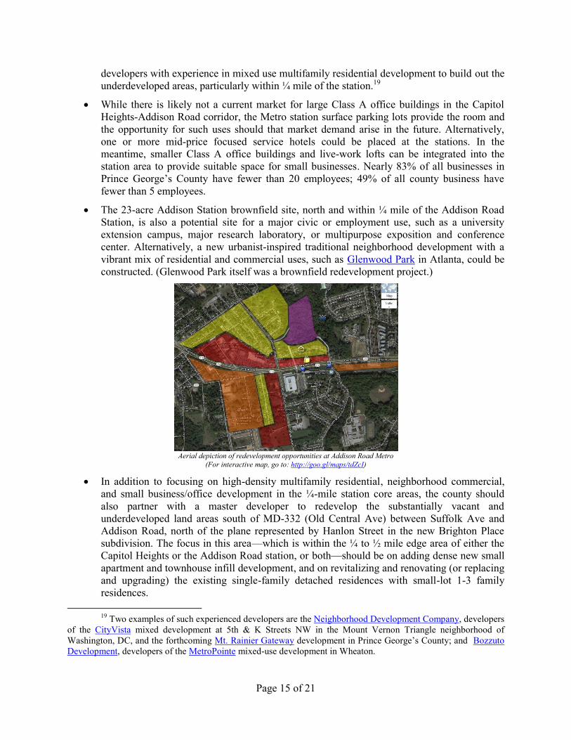
The 23-acre Addison Station brownfield site, north and within ¼ mile of the Addison Road
Station, is also a potential site for a major civic or employment use, such as a university
extension campus, major research laboratory, or multipurpose exposition and conference
center. Alternatively, a new urbanist-inspired traditional neighborhood development with a
vibrant mix of residential and commercial uses, such as Glenwood Park in Atlanta, could be
constructed. (Glenwood Park itself was a brownfield redevelopment project.)
Aerial depiction of redevelopment opportunities at Addison Road Metro
(For interactive map, go to: http://goo.gl/maps/tdZcI)
In addition to focusing on high-density multifamily residential, neighborhood commercial,
and small business/office development in the ¼-mile station core areas, the county should
also partner with a master developer to redevelop the substantially vacant and
underdeveloped land areas south of MD-332 (Old Central Ave) between Suffolk Ave and
Addison Road, north of the plane represented by Hanlon Street in the new Brighton Place
subdivision. The focus in this area—which is within the ¼ to ½ mile edge area of either the
Capitol Heights or the Addison Road station, or both—should be on adding dense new small
apartment and townhouse infill development, and on revitalizing and renovating (or replacing
and upgrading) the existing single-family detached residences with small-lot 1-3 family
residences.
19
Two examples of such experienced developers are the Neighborhood Development Company, developers
of the CityVista mixed development at 5th & K Streets NW in the Mount Vernon Triangle neighborhood of
Washington, DC, and the forthcoming Mt. Rainier Gateway development in Prince George’s County; and Bozzuto
Development, developers of the MetroPointe mixed-use development in Wheaton.
Page 16 of 21
With an average build-out density of 36 DU/Ac and 200 acres of redevelopable land, this
combined urban neighborhood could easily support 7,200 or more new dwelling units. This
would result in a hefty boost to the county’s property tax rolls, even without any major
commercial or office uses—certainly enough to recoup any expenses related to public
infrastructure improvements.
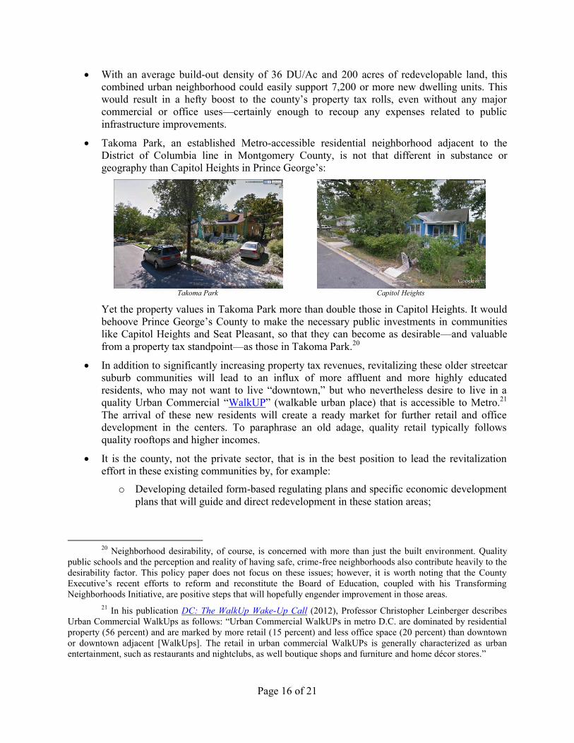
Takoma Park, an established Metro-accessible residential neighborhood adjacent to the
District of Columbia line in Montgomery County, is not that different in substance or
geography than Capitol Heights in Prince George’s:
Takoma Park
Capitol Heights
Yet the property values in Takoma Park more than double those in Capitol Heights. It would
behoove Prince George’s County to make the necessary public investments in communities
like Capitol Heights and Seat Pleasant, so that they can become as desirable—and valuable
from a property tax standpoint—as those in Takoma Park.20
In addition to significantly increasing property tax revenues, revitalizing these older streetcar
suburb communities will lead to an influx of more affluent and more highly educated
residents, who may not want to live “downtown,” but who nevertheless desire to live in a
quality Urban Commercial “WalkUP” (walkable urban place) that is accessible to Metro.21
The arrival of these new residents will create a ready market for further retail and office
development in the centers. To paraphrase an old adage, quality retail typically follows
quality rooftops and higher incomes.
It is the county, not the private sector, that is in the best position to lead the revitalization
effort in these existing communities by, for example:
o Developing detailed form-based regulating plans and specific economic development
plans that will guide and direct redevelopment in these station areas;
20
Neighborhood desirability, of course, is concerned with more than just the built environment. Quality
public schools and the perception and reality of having safe, crime-free neighborhoods also contribute heavily to the
desirability factor. This policy paper does not focus on these issues; however, it is worth noting that the County
Executive’s recent efforts to reform and reconstitute the Board of Education, coupled with his Transforming
Neighborhoods Initiative, are positive steps that will hopefully engender improvement in those areas.
21 In his publication DC: The WalkUp Wake-Up Call (2012), Professor Christopher Leinberger describes
Urban Commercial WalkUps as follows: “Urban Commercial WalkUPs in metro D.C. are dominated by residential
property (56 percent) and are marked by more retail (15 percent) and less office space (20 percent) than downtown
or downtown adjacent [WalkUps]. The retail in urban commercial WalkUPs is generally characterized as urban
entertainment, such as restaurants and nightclubs, as well boutique shops and furniture and home décor stores.”
Page 17 of 21
o Identifying and acquiring the necessary property to construct the neighborhood streets
to form street grids and urban alleyways where such networks are missing;
o Completing the sidewalk network and installing bike lanes on existing neighborhood
streets;
o Converting higher speed-rated, automobile-oriented state highways and county roads
into lower speed-rated, multi-modal urban boulevards by lowering speed limits,
reducing roadway widths, installing street trees and street lights, bike lanes, wide
sidewalks, signalized crosswalks and Hawk signals, pedestrian refuge medians,
bulbouts, etc.;
o Burying and relocating utility lines in established neighborhoods;
o Assisting with the acquisition and/or assembly of disparately owned, blighted, and/or
underdeveloped land to carry out an identified economic development plan;
o Developing RFQs and RFPs and identifying suitable private developers with whom
to partner in the redevelopment plan; and
o Partnering with existing residents and homeowners to remedy exterior maintenance
issues and code violations that detract from the appearance of the neighborhood and
act as a barrier to redevelopment (e.g., by identifying grants and low-interest loan
opportunities and partnering with a group of preferred service providers who are
willing to provide specified services to homeowners at a discounted volume rate)
Capitol Heights and Addison Road stations (along with the other Blue Line Corridor stations,
Morgan Boulevard and Largo Town Center) have already been designated Sustainable
Communities by the State of Maryland. This makes these station areas eligible for a powerful
array of state revitalization funding, including:
o Income tax credits of 10-25% for qualifying property rehabilitations through the
Sustainable Communities Tax Credit Program; and
o State-backed tax-increment finance (TIF) bonds, through the Maryland Economic
Development Corporation (MEDCO), to fund the cost of infrastructure
improvements. This puts these stations in the same position as the MDOT-designated
TOD sites (Branch Avenue, New Carrollton, and Naylor Road) for state
infrastructure and revitalization funding prioritization purposes.22
In Sustainable Communities, MEDCO TIF bond funds can be used to fund acquisition of
property needed for rights-of-way; business and resident relocation necessitated by
development in the area; utility relocation and installation; streets, lighting, sidewalks, and
trails; parks and recreation facilities; historic preservation and remediation; environmental
remediation, demolition, and site preparation; construction of affordable housing and
neighborhood schools; storm water management; and construction of parking structures and
facilities, among other things.
22
This powerful new funding tool was recently passed by the General Assembly as HB 613 and signed into
law by Governor O’Malley on May 16, 2013. It becomes effective on October 1, 2013.
Page 18 of 21
With these powerful tools at its disposal, there is no sound business or policy reason for the
county not to include Addison Road and Capitol Heights among the Priority Investment
Districts (PIDs).
Suggested Prioritization of TOD Resources
In sum, the county should identify the following 3 stations as the initial Priority Investment
Districts (PIDs): New Carrollton, Addison Road, and Capitol Heights.
o It makes sense for the county to focus on only one CBD at a time. This sends a clear
signal to the business community as to where the county would like to see large
concentrations of major employers locate.
o Although it will require substantially more in terms of infrastructure investments and
improvements than Largo, New Carrollton is the obvious choice as the first CBD
focus area, given its status as the region’s second most significant transportation hub.
Once a critical mass of major employers develops at New Carrollton, the county
should begin to prioritize development at the Largo CBD. (In the meantime, the
county should begin planning, designing, and acquiring the necessary property for the
relocation of the county seat to Largo.)
o As it develops its first business-oriented Downtown WalkUP at New Carrollton, the
county should also focus its attention on developing vibrant and iconic residentially-
oriented Urban Commercial WalkUPs at Addison Road and Capitol Heights. From
these stations, residents are a short 25-minute Metro ride away from downtown
Washington, DC, as well as the New Carrollton CBD. They are also directly
connected via Metro to Reagan National Airport and, eventually, Dulles International
Airport. Residents will also have convenient access to the southern Green Line
stations via the Addison Road/Suitland/National Harbor Transitway.
o With these two projects working in tandem, the county can announce to the
Washington region that it has entered into a “new era of urbanism, scaled for business
and for lifestyle pleasure.”
Designating New Carrollton, Addison Road, and Capitol Heights as the three initial PIDs to
incentivize and catalyze private sector development does not mean that the county should
ignore other major public sector opportunities at other Metro stations. In particular, the
county should continue to pursue the UMMS regional hospital development at Largo and the
new FBI headquarters relocation to Greenbelt, and it should continue to support the ongoing
discussions between GSA and WMATA for joint development opportunities at Branch
Avenue.
o As previously discussed, those stations are already more poised than the three
proposed PIDs for immediate development without the need for additional major
infrastructure enhancements.
o Additionally, the federal and state governments have the inherent ability to directly
fund their own projects, as a means of stimulating local economies, and therefore act
as catalyzing forces in their own right. The county can be an effective strategic
partner in such efforts, but it should not seek to undertake primary financial or
operational responsibility for them.
Page 19 of 21
The county should allocate its TOD efforts (both in terms of financial and time resources) as
follows:
o 40% toward the New Carrollton CBD area;
o 30% toward the Capitol Heights and Addison Road Urban Neighborhood areas;
o 10% toward marketing and promoting the prime federal and state government TOD
opportunities available at the Largo CBD and the Major Urban Districts served by
Metro; and
o 20% toward structural reforms (e.g., effectuating the countywide rezoning that will
implement the revised tier structure discussed herein; revising and simplifying the
zoning and subdivision ordinances; reevaluating the impact and surcharge fee
structures and updating the APF ordinance; and de-politicizing the development
review process by eliminating discretionary council call-ups under Subtitle 27A)
As an additional means of encouraging form-based code development around transit stations
under Subtitle 27A and generally prioritizing development review in accordance with the
county’s growth strategies, M-NCPPC should modify its development review process as
follows:
o The 70-day period for Planning Department staff review and action on permit site
applications under Subtitle 27A should be prioritized as follows:
Development proposals in PIDs and CBDs should be reviewed and acted
upon within 30 days.
Development proposals in other major place typologies (i.e., Major Urban
Districts, Neighborhood Urban Districts, and Special Use/Employment
Districts) should be reviewed and acted upon within 45 days.
All other development proposals under Subtitle 27A should be reviewed and
acted upon within the required 70 days.
o The 70-day period for Planning Board action on all site plans under the regular
Zoning Ordinance (Subtitle 27) should be extended to 120 days and should be
prioritized as follows:
All residential development proposals, in whatever zone, relating only to 1-4
DUs should be reviewed and acted upon within 60 days. (Planning Director
or designee action on residential permit applications in the “Residential-
Infill” DDOZ should also be accomplished within this same time frame.)
Development proposals in Comprehensive Design Zones should be reviewed
and acted upon within 90 days.
Development proposals in all other zoning categories should be reviewed and
acted upon within 120 days.
PLANNING FOR FUTURE CONNECTIVITY AND CAPACITY
As Prince George’s County continues to grow smartly downtown and beyond, its transit
system will need to become more robust, and its seat of government will need to become more
Page 20 of 21
accessible to the people. Below are some recommended ways that the county can plan now to ensure
future connectivity and increased capacity in a manner that continues to preserve our precious natural
and financial resources.
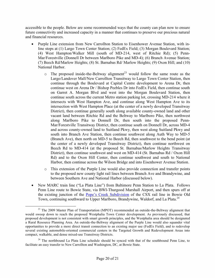
Purple Line extension from New Carrollton Station to Eisenhower Avenue Station, with in-
line stops at (1) Largo Town Center Station; (2) FedEx Field; (3) Morgan Boulevard Station;
(4) West Hampton/Walker Mill (south of MD-214, west of Ritchie Rd); (5) Penn-
Mar/Forestville (Donnell Dr between Marlboro Pike and MD-4); (6) Branch Avenue Station;
(7) Beech Rd/Marlow Heights; (8) St. Barnabas Rd/ Marlow Heights; (9) Oxon Hill; and (10)
National Harbor.
o The proposed inside-the-Beltway alignment23 would follow the same route as the
Largo/Landover Mall/New Carrollton Transitway to Largo Town Center Station, then
continue through the Boulevard at Capital Centre development to Arena Dr, then
continue west on Arena Dr / Bishop Peebles Dr into FedEx Field, then continue south
on Garret A. Morgan Blvd and west into the Morgan Boulevard Station, then
continue south across the current Metro station parking lot, crossing MD-214 where it
intersects with West Hampton Ave, and continue along West Hampton Ave to its
intersection with West Hampton Place (at the center of a newly developed Transitway
District), then continue generally south along available county-owned land and other
vacant land between Ritchie Rd and the Beltway to Marlboro Pike, then northwest
along Marlboro Pike to Donnell Dr, then south into the proposed Penn-
Mar/Forestville Transitway District, then continue south on Donnell Dr, across MD-4
and across county-owned land to Suitland Pkwy, then west along Suitland Pkwy and
south into Branch Ave Station, then continue southwest along Auth Way to MD-5
(Branch Ave), then north on MD-5 to Beech Rd, then southwest to the bend point (at
the center of a newly developed Transitway District), then continue northwest on
Beech Rd to MD-414 (at the proposed St. Barnabas/Marlow Heights Transitway
District), then continue southwest and west on MD-414 (St. Barnabas Rd / Oxon Hill
Rd) and to the Oxon Hill Center, then continue southwest and south to National
Harbor, then continue across the Wilson Bridge and into Eisenhower Avenue Station.
o This extension of the Purple Line would also provide connection and transfer points
to the proposed new county light rail lines between Branch Ave and Brandywine, and
between Southern Ave and National Harbor (discussed below).
New MARC train line (“La Plata Line”) from Baltimore Penn Station to La Plata. Follows
Penn Line route to Bowie State, via BWI-Thurgood Marshall Airport, and then spurs off at
the existing junction of the Pope’s Creek Subdivision of the CSX rail line in Bowie Old
Town, continuing southward to Upper Marlboro, Brandywine, Waldorf, and La Plata.24
23
The 2009 Master Plan of Transportation (MPOT) recommended an outside-the-Beltway alignment that
would swoop down to reach the proposed Westphalia Town Center development. As previously discussed, that
proposed development is not consistent with smart growth principles, and the Westphalia area should be designated
a Rural Resource Planning Area. An outside-the-Beltway alignment of the Purple Line would also squander vital
opportunities to provide a more direct transit connection to an existing major use (FedEx Field), and to redevelop
several existing automobile-oriented commercial centers in the Targeted Growth and Redevelopment Areas into
compact, walkable, and dense mixed-use Transitway Districts.
24 The northbound La Plata Line schedule should be synced with that of the southbound Penn Line, to
facilitate an easy transfer to New Carrollton and Washington, DC, at Bowie State.
Page 21 of 21
New county light rail line from Branch Avenue Station to Brandywine, with stops in Camp
Springs South, Clinton, Brandywine Rail Depot, and South Brandywine (between
Brandywine Crossing and a redeveloped Soil Safe site).
New county light rail line from Southern Avenue Station to National Harbor, along the same
alignment as the Southern Ave/Indian Head Ave/National Harbor Urban Transitway.
Relocate the county seat to Largo, in the Inglewood Business Park. Redevelop McCormick
Drive into a Main Street, with iconic LEED Gold-certified, new urbanist designed county
office buildings. This location is proposed to be an eventual stop on the extended Purple Line
and, in the meantime, would be served by frequent buses from Largo Town Center and New
Carrollton stations.
Establish a mixed-use sub-district at the new Upper Marlboro Rail Depot and along MD-725
(Main Street/Old Marlboro Pike) east to US-301 once the new MARC La Plata Line is
constructed. An automated people mover (tram or moving sidewalk) should run along the ½-
mile route on MD-725 (Main Street) between the rail depot and the center of the existing
Transitway District at Upper Marlboro, which will provide significant additional infill
development opportunities once the county seat is relocated to Largo.
About the Author: Bradley E. Heard is a federal civil rights attorney, citizen activist, and smart
growth enthusiast who has lived in Prince George’s County since 2007, currently residing in the
Capitol Heights area of the inner Beltway. A regular transit rider, Brad frequently writes on smart
growth, transit-oriented development, and political governance and accountability issues for Greater
Greater Washington, a news and opinion blog devoted to improving the vitality of walkable cities and
communities in the Washington metropolitan area.
Brad has worked with groups such as the Coalition for Smarter Growth, the Partnership for Renewal
in Southern and Central Maryland (PRISCM), and the Prince George’s Green Power Coalition to put
on public presentations and to engage county officials in positive dialogue around sustainable growth
and community revitalization issues. He also frequently attends and offers public comments in
connection with comprehensive planning efforts and individual development review proceedings.
The opinions expressed in this work are the author’s own and do not necessarily represent those of
any organization with which he is professionally or otherwise affiliated.
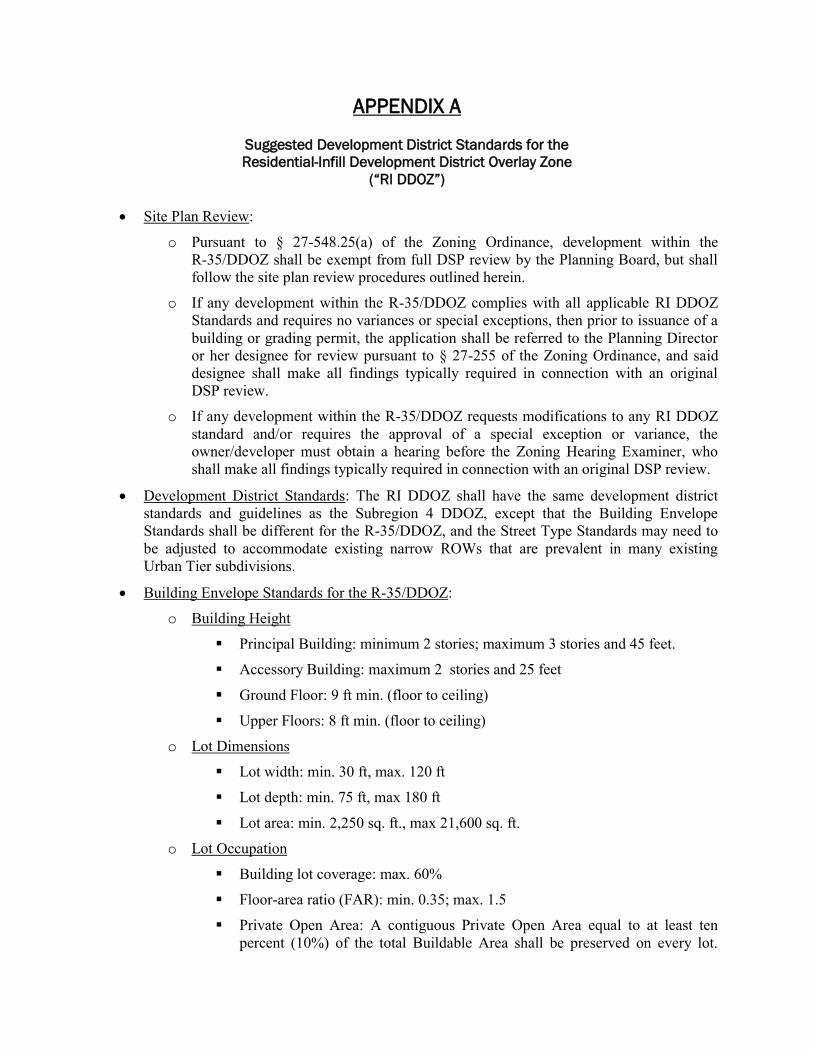
APPENDIX A
Suggested Development District Standards for the
Residential-Infill Development District Overlay Zone
(“RI DDOZ”)
Site Plan Review:
o Pursuant to § 27-548.25(a) of the Zoning Ordinance, development within the
R-35/DDOZ shall be exempt from full DSP review by the Planning Board, but shall
follow the site plan review procedures outlined herein.
o If any development within the R-35/DDOZ complies with all applicable RI DDOZ
Standards and requires no variances or special exceptions, then prior to issuance of a
building or grading permit, the application shall be referred to the Planning Director
or her designee for review pursuant to § 27-255 of the Zoning Ordinance, and said
designee shall make all findings typically required in connection with an original
DSP review.
o If any development within the R-35/DDOZ requests modifications to any RI DDOZ
standard and/or requires the approval of a special exception or variance, the
owner/developer must obtain a hearing before the Zoning Hearing Examiner, who
shall make all findings typically required in connection with an original DSP review.
Development District Standards: The RI DDOZ shall have the same development district
standards and guidelines as the Subregion 4 DDOZ, except that the Building Envelope
Standards shall be different for the R-35/DDOZ, and the Street Type Standards may need to
be adjusted to accommodate existing narrow ROWs that are prevalent in many existing
Urban Tier subdivisions.
Building Envelope Standards for the R-35/DDOZ:
o Building Height
Principal Building: minimum 2 stories; maximum 3 stories and 45 feet.
Accessory Building: maximum 2 stories and 25 feet
Ground Floor: 9 ft min. (floor to ceiling)
Upper Floors: 8 ft min. (floor to ceiling)
o Lot Dimensions
Lot width: min. 30 ft, max. 120 ft
Lot depth: min. 75 ft, max 180 ft
Lot area: min. 2,250 sq. ft., max 21,600 sq. ft.
o Lot Occupation
Building lot coverage: max. 60%
Floor-area ratio (FAR): min. 0.35; max. 1.5
Private Open Area: A contiguous Private Open Area equal to at least ten
percent (10%) of the total Buildable Area shall be preserved on every lot.
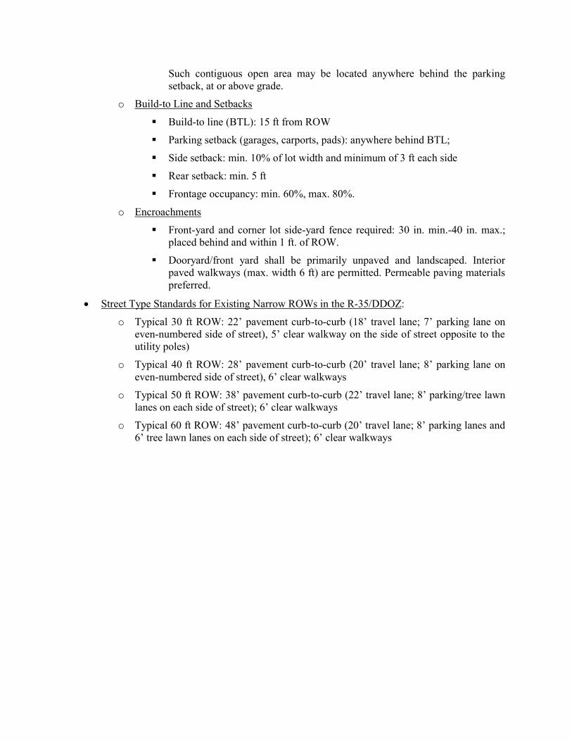
Such contiguous open area may be located anywhere behind the parking
setback, at or above grade.
o Build-to Line and Setbacks
Build-to line (BTL): 15 ft from ROW
Parking setback (garages, carports, pads): anywhere behind BTL;
Side setback: min. 10% of lot width and minimum of 3 ft each side
Rear setback: min. 5 ft
Frontage occupancy: min. 60%, max. 80%.
o Encroachments
Front-yard and corner lot side-yard fence required: 30 in. min.-40 in. max.;
placed behind and within 1 ft. of ROW.
Dooryard/front yard shall be primarily unpaved and landscaped. Interior
paved walkways (max. width 6 ft) are permitted. Permeable paving materials
preferred.
Street Type Standards for Existing Narrow ROWs in the R-35/DDOZ:
o Typical 30 ft ROW: 22’ pavement curb-to-curb (18’ travel lane; 7’ parking lane on
even-numbered side of street), 5’ clear walkway on the side of street opposite to the
utility poles)
o Typical 40 ft ROW: 28’ pavement curb-to-curb (20’ travel lane; 8’ parking lane on
even-numbered side of street), 6’ clear walkways
o Typical 50 ft ROW: 38’ pavement curb-to-curb (22’ travel lane; 8’ parking/tree lawn
lanes on each side of street); 6’ clear walkways
o Typical 60 ft ROW: 48’ pavement curb-to-curb (20’ travel lane; 8’ parking lanes and
6’ tree lawn lanes on each side of street); 6’ clear walkways