Embed Size (px)
Citation preview

Wyoming Game and Fish Department “Plan Your Hunt” Hunt Area Map
General Use Information
** These maps are for visual use, assistance and general location only, do not represent a survey, and are not to be used for legal conveyance. Area boundaries are approximate, consult Game and Fish Regulations for descriptions and restrictions.
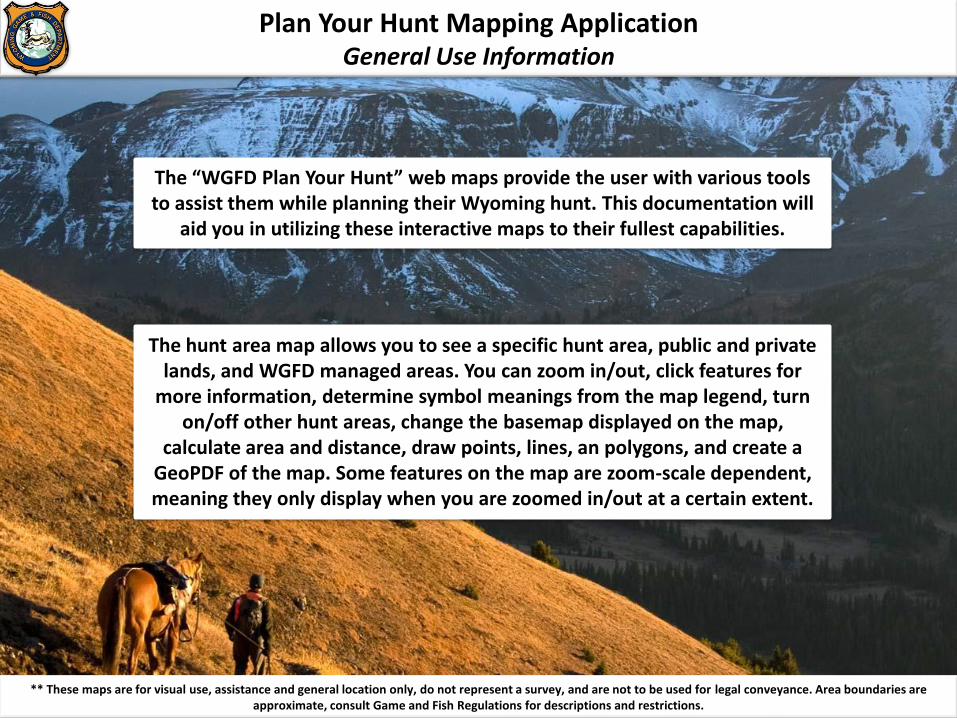
Plan Your Hunt Mapping Application General Use Information
The “WGFD Plan Your Hunt” web maps provide the user with various tools to assist them while planning their Wyoming hunt. This documentation will
aid you in utilizing these interactive maps to their fullest capabilities.
The hunt area map allows you to see a specific hunt area, public and private lands, and WGFD managed areas. You can zoom in/out, click features for
more information, determine symbol meanings from the map legend, turn on/off other hunt areas, change the basemap displayed on the map,
calculate area and distance, draw points, lines, an polygons, and create a GeoPDF of the map. Some features on the map are zoom-scale dependent, meaning they only display when you are zoomed in/out at a certain extent.
** These maps are for visual use, assistance and general location only, do not represent a survey, and are not to be used for legal conveyance. Area boundaries are approximate, consult Game and Fish Regulations for descriptions and restrictions.

Plan Your Hunt Mapping Application Hunt Area Map Overview
Zoom In
Zoom Out
Reset View
View Legend
Turn On/Off Layers
Change Basemaps
Clickable Features
Multiple Features Selected
** These maps are for visual use, assistance and general location only, do not represent a survey, and are not to be used for legal conveyance. Area boundaries are approximate, consult Game and Fish Regulations for descriptions and restrictions.
Location Services
Search
Measure Tools
Drawing Tools
Print to GeoPDF
Disclaimer

Plan Your Hunt Mapping Application Search, Zoom In, Zoom Out, Reset View, and Location Services
Zoom In: Each click of the “Zoom-In” button will zoom into the map a single zoom level.
** These maps are for visual use, assistance and general location only, do not represent a survey, and are not to be used for legal conveyance. Area boundaries are approximate, consult Game and Fish Regulations for descriptions and restrictions.
Zoom Out: Each click of the “Zoom-Out” button will zoom out the map a single zoom level.
Reset View: This button will reset the map to the default zoom level.
Search: Search for cities, counties, landmarks, etc… It will locate your search and zoom in to that
location.
Location Services: This will enable location services, if allowed on your device. If you are in the field and viewing this map on your mobile device,
and GPS is enable on your device, you can click this button and your location will be displayed as a
blue dot on the map. This will allow you to navigate this map while in the field.

Plan Your Hunt Mapping Application Legend, Turn On/Off Layers, and Basemaps
Turn On/Off Layers: This allows the user to toggle between the available map data. You can turn on multiple
hunt areas for different species.
Change Basemaps: The basemap is the underlying image that provides
the background on the map. You can display any basemap from the
provided options. Basemaps include: Imagery, Imagery with labels, Streets, Topographic, Light and Dark canvas,
and other terrain-style maps.
** These maps are for visual use, assistance and general location only, do not represent a survey, and are not to be used for legal conveyance. Area boundaries are approximate, consult Game and Fish Regulations for descriptions and restrictions.
Legend: The map legend identifies the meaning of all the features on the map.
Remember, some features on the map are zoom-dependent. If you are zoomed out to a certain extent some features will not be visible, therefore they will also not display
on the legend.

Plan Your Hunt Mapping Application Measure Tool, Drawing Tool, and Print to GeoPDF
Drawing Tool: Provides tools that allow you to draw points, lines, polygons, and text on the map.
When you “Print to GeoPDF”, it will also includes your drawings.
Print to GeoPDF: This will allow you to generate a PDF map of the area
shown on your screen. Then you can print it out or use it on your cellular
device to navigate in the field. (See GeoPDF)
** These maps are for visual use, assistance and general location only, do not represent a survey, and are not to be used for legal conveyance. Area boundaries are approximate, consult Game and Fish Regulations for descriptions and restrictions.
Measure Tool: This tool allows you to measure area, distance, or get the
latitude/longitude of a specific point. Units of measure include feet, miles, acres, etc…

Plan Your Hunt Mapping Application Clickable and Multiple Features
** These maps are for visual use, assistance and general location only, do not represent a survey, and are not to be used for legal conveyance. Area boundaries are approximate, consult Game and Fish Regulations for descriptions and restrictions.
Clickable Features: Clicking on different features within the map
provides more information for that particular feature. A popup window will open up and display additional information related to that feature. The selected feature will also become highlighted on
the map
Multiple Features Selected: If you click and select an area on the map that has multiple features overlaying that specific location, the popup window will display (1 of …). You will also notice a little white arrow at
the top of the window. The arrow allows you to scroll through the additional features selected.