Embed Size (px)
Citation preview
Titan Saturn System Mission 1
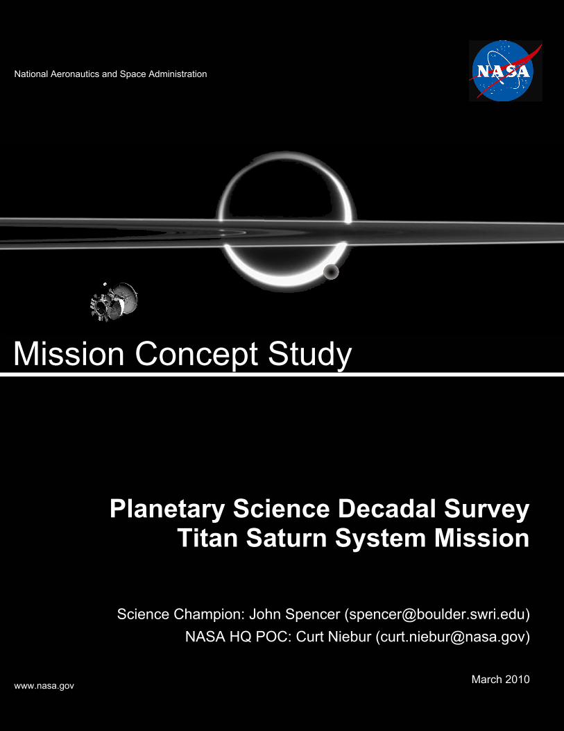
Planetary Science Decadal SurveyTitan Saturn System Mission
Science Champion: John Spencer ([email protected])NASA HQ POC: Curt Niebur ([email protected])
March 2010 www.nasa.gov
Mission Concept Study
National Aeronautics and Space Administration

Titan Saturn System Mission i
Data Release, Distribution, and Cost Interpretation Statements This document is intended to support the SS2012 Planetary Science Decadal Survey.
The data contained in this document may not be modified in any way.
Cost estimates described or summarized in this document were generated as part of a preliminary concept study, are model-based, assume a JPL in-house build, and do not constitute a commitment on the part of JPL or Caltech. References to work months, work years, or FTEs generally combine multiple staff grades and experience levels.
Cost reserves for development and operations were included as prescribed by the NASA ground rules for the Planetary Science Decadal Survey. Unadjusted estimate totals and cost reserve allocations would be revised as needed in future more-detailed studies as appropriate for the specific cost-risks for a given mission concept.
Titan Saturn System Mission i
Planetary Science Decadal Survey Mission Concept Study Final Report
Acknowledgments ........................................................................................................ iv
Executive Summary ...................................................................................................... v Overview ....................................................................................................................................... v
Background ................................................................................................................................... v
Study Approach ........................................................................................................................... vi
Science Overview ....................................................................................................................... vii
Mission Architecture Assessment ............................................................................................... viii
Mission Implementation ............................................................................................................... ix
Cost, Schedule, and Risk ............................................................................................................ xii
Summary and Conclusions ........................................................................................................ xiv
1. Scientific Objectives ............................................................................................ 1 Science Questions and Objectives ............................................................................................... 1
Science Traceability ...................................................................................................................... 2
2. High-Level Mission Concept ............................................................................. 34 Overview ..................................................................................................................................... 34
Concept Maturity Level ............................................................................................................... 34
Technology Maturity .................................................................................................................... 34
Key Trades .................................................................................................................................. 35
3. Technical Overview ............................................................................................ 38 Instrument Payload Description .................................................................................................. 38
Baseline Flight System ............................................................................................................... 44
Baseline Concept of Operations and Mission Design ................................................................. 50
Planetary Protection .................................................................................................................... 53
Risk List ...................................................................................................................................... 53

Titan Saturn System Mission ii
4. Development Schedule and Schedule Constraints ......................................... 54 High-Level Mission Schedule ...................................................................................................... 54
Technology Development Plan ................................................................................................... 58
Development Schedule and Constraints ..................................................................................... 58
5. Mission Life-Cycle Cost ..................................................................................... 59 Costing Methodology and Basis of Estimate .............................................................................. 59
Cost Estimates ............................................................................................................................ 59
Figures Figure ES-1. NASA/ESA geographically diverse team operates as a seamless integrated unit
incorporating lessons learned from the Cassini-Huygens model. ........................................... vi
Figure ES-2. The TSSM orbiter will have multiple opportunities to sample Enceladus’ plumes. ............... viii
Figure ES-3. TSSM’s Baseline architecture maximizes science return to investment ratio within NASA and
ESA resources, at risk comparable to Cassini-Huygens. ........................................................ ix
Figure ES-4. NASA/ESA and NASA-only mission architectures include robust descopes while remaining
above the science floor. ........................................................................................................... ix
Figure ES-5. Baseline mission concept includes coordinated orbital observation and in situ elements. ..... x
Figure ES-6. Top-level Baseline mission timeline. ..................................................................................... xiii
Figure 3-1. Risk Matrix ................................................................................................................................ 53
Figure 4-1. Schedule—Orbiter .................................................................................................................... 55
Figure 4-2. Schedule—Montgolfière / Lake Lander .................................................................................... 57
Figure 4-3. Schedule—Orbiter Testbed / ATLO.......................................................................................... 58
Tables Table ES-1. TSSM science goals. .............................................................................................................. viii
Table ES-2. Key mission characteristics of the TSSM Baseline mission concept. ....................................... xi
Table 1-1. Science Traceability Matrix—Orbiter ........................................................................................... 2
Table 1-2. Science Traceability Matrix—Montgolfière ................................................................................ 17
Table 1-3. Science Traceability Matrix—Lake Lander ................................................................................ 28
Table 2-1. Concept Maturity Level Definitions ............................................................................................ 34
Table 3-1. Instrument Specifications—Orbiter ............................................................................................ 39
Table 3-2. Payload Mass and Power—Orbiter ........................................................................................... 40
Table 3-3. Instrument Specifications—Montgolfière ................................................................................... 41
Table 3-4. Payload Mass and Power—Montgolfière .................................................................................. 42

Titan Saturn System Mission iii
Table 3-5. Instrument Specifications—Lake Lander ................................................................................... 43
Table 3-6. Payload Mass and Power—Lake Lander .................................................................................. 44
Table 3-7. Flight System Element Mass and Power—Orbiter .................................................................... 44
Table 3-8. Flight System Element Characteristics—Orbiter ....................................................................... 44
Table 3-9. Flight System Element Mass and Power—SEP Stage .............................................................. 46
Table 3-10. Flight System Element Characteristics—SEP Stage ............................................................... 46
Table 3-11. Flight System Element Mass and Power—Montgolfière ......................................................... 47
Table 3-12. Flight System Element Characteristics—Montgolfière ............................................................ 48
Table 3-13. Flight System Element Mass and Power—Lake Lander ......................................................... 49
Table 3-14. Flight System Element Characteristics—Lake Lander ............................................................ 49
Table 3-15. Mission Design ......................................................................................................................... 50
Table 3-16. Mission Operations and Ground Data Systems—Orbiter ........................................................ 51
Table 3-17. Mission Operations and Ground Data Systems—Montgolfière ............................................... 52
Table 3-18. Mission Operations and Ground Data Systems—Lander ....................................................... 52
Table 4-1. Key Phase Duration—Orbiter .................................................................................................... 54
Table 4-2. Key Phase Duration—Montgolfière and Lake Lander ............................................................... 56
Table 5-1. Total Mission Cost Funding Profile—Orbiter ............................................................................. 60
Appendices
A. Acronyms
B. References

Titan Saturn System Mission iv
Acknowledgments This research was carried out at the Jet Propulsion Laboratory, California Institute of Technology, under a contract with the National Aeronautics and Space Administration.
© 2010. All rights reserved.

Titan Saturn System Mission v
Executive Summary (Taken directly from Titan Saturn System Mission Study 2008: Final Report [1], Section 1.)
Overview Titan is a high priority for exploration, as recommended by NASA’s 2006 Solar System Exploration (SSE) Roadmap (NASA 2006), NASA’s 2003 National Research Council (NRC) Decadal Survey (NRC Space Studies Board 2003) and ESA’s Cosmic Vision Program Themes. Recent revolutionary Cassini-Huygens discoveries have dramatically escalated interest in Titan as the next scientific target in the outer Solar System. This study demonstrates that an exciting Titan Saturn System Mission (TSSM) that explores two worlds of intense astrobiological interest can be initiated now as a single NASA/ESA collaboration.
The Cassini-Huygens mission has revealed the Earth-like world of Saturn's moon Titan and showed the potential habitability of another moon, Enceladus. As anticipated by the 2003 Decadal Survey, recent Cassini-Huygens discoveries have revolutionized our understanding of the Titan system and its potential for harboring the “ingredients” necessary for life. These discoveries reveal that Titan is very rich in organics, possibly contains a vast subsurface ocean, and has energy sources to drive chemical evolution. The complex interaction between the atmosphere and surface produces lakes, dunes, and seasonal changes that are features that Titan shares with Earth. Cassini’s discovery of active geysers on Enceladus revealed a second icy moon in the Saturn system that is synergistic with Titan in understanding planetary evolution and in adding another potential abode in the Saturn system for life as we know it. These discoveries have dramatically escalated the interest in Titan as the next scientific target for an outer Solar System mission.
Although the scope of science possible at Titan covers the entire range of planetary science disciplines, the TSSM team has developed a mission architecture that focuses NASA and ESA resources on the highest priority science questions. Results of this study confirm that a flagship-class mission to Titan (including the Saturn system and Enceladus) could be done at acceptable risk within the specified budgetary constraints and can proceed now.
Background NASA and ESA are completing Pre-Phase A concept studies in support of a joint selection process for the next Outer Planet Flagship Mission (OPFM).
The Titan Saturn System Mission (TSSM) study was directed to redesign the 2007 Titan Explorer mission concept to meet new constraints specified under the revised Requirements and Ground Rules document (2008) and Statement of Work (2008), key elements of which are listed below.
Respond to the 2007 Study independent review board findings.
Produce a mission concept that optimally balances science, cost, and risk.
Define a NASA/ESA Baseline and Floor mission that includes a NASA-provided Titan orbiter that would not utilize aerocapture. The orbiter shall have the capability of delivering and providing relay communications for multiple Titan in situ elements that would be provided by ESA as part of a collaborative program.
Define a NASA-only mission and Floor mission that could be implemented by NASA in the event ESA does not participate.
Include Saturn system and Enceladus as Level 1 science requirements to the extent they inform us about Titan.
Include minimum of 33% reserves/margins in all areas.

Titan Saturn System Mission vi
Use a launch date of 2020 for schedule and cost purposes. Alternative launch dates from 2018 through 2022 should be identified.
This study and its predecessors are intended to support a joint NASA-ESA down-select to a single OPFM expected in February 2009.
Study Approach TSSM builds upon the results of more than a decade of previous studies as well as thorough science assessment, rigorous systems engineering, and experience gained from the Cassini-Huygens mission to develop a high fidelity concept in support of the NASA/ESA OPFM down-selection process.
An international science and technical team was formed with the goal to develop a focused, cost-effective TSSM (Figure ES-1). NASA and ESA formed a Joint Science Definition Team (JSDT) with 16 US and 15 European members. It was led by a NASA-appointed co-chair (from the University of Arizona, UA) and an ESA-appointed co-chair (from ESA/ESTEC) that established science objectives and participated in the design of the mission. JPL and ESA jointly formed the technical team with members from JPL, APL, NASA Glenn, ESA/ESTEC, ESA/ESOC, and CNES. It designed the mission and its elements. The JSDT and technical team worked as an integrated unit to define a mission that fully responds to the Statement of Work and Ground Rules for this study. This was achieved by establishing science goals and objectives that derive directly from guiding documents and then tracing these forward to define a planning payload and technical requirements on the mission as described in §2.0 and §4.1.1. These provided the basis for the team to develop a concept that balances cost and risk and achieves the science goals established by the JSDT as described in §2.0.
The Baseline Mission concept developed by the study team includes a NASA orbiter with Solar Electric Propulsion (SEP) stage and ESA provided lander and montgolfière balloon. The floor for this NASA-ESA mission preserves all flight elements except the SEP stage with the impact of taking as much as 1.5 years longer to reach Saturn.
Figure ES-1. NASA/ESA geographically diverse team operates as a seamless integrated unit incorporating lessons learned from the Cassini-Huygens model.

Titan Saturn System Mission vii
Science Overview Titan, a rich, diverse body offering the potential for extraordinary scientific return, is emerging as the compelling choice for the next Outer Planet Flagship Mission.
Titan, a complex, Earth-like moon with organics, shares features both with other large icy satellites and the terrestrial planets. It is subjected to tidal stresses, and its surface has been modified tectonically to form mountains. It is likely that cryovolcanism exists where liquid water, perhaps in concert with ammonia and carbon dioxide, makes its way to the surface from the interior. Cassini revealed that Titan has the largest accessible inventory of organic material in the solar system aside from Earth, and its active hydrological cycle is analogous to that of Earth, but with methane replacing water. Titan’s clouds, rain, flash floods, and greenhouse and anti-greenhouse effects might provide important lessons for Earth’s long-term climate evolution. Albeit with dramatically different chemistry, Titan’s landscape appears remarkably Earth-like, featuring dunes, fluvial channels, and mountain ridges, as well as polar lakes filled with liquid hydrocarbons. Titan’s dense atmosphere is mostly nitrogen—like Earth’s—and varies seasonally in temperature, dynamical behavior, and composition, including a winter polar structure analogous to Earth’s ozone hole. Finally, although Titan is similar to Earth in many ways, its atmosphere is unique in the solar system, experiencing strong dynamical forcing by gravitational tides (a trait Titan may share with many extrasolar planets). A mission launched in the 2018–2022 timeframe would provide a unique opportunity to measure a seasonal phase complementary to that observed by Voyager and by Cassini, including its extended missions.
Recent discoveries of the complex interactions of Titan’s atmosphere with the surface, interior, and space environment demand focused and enduring observation over a range of temporal and spatial scales. The TSSM two-year orbital mission at Titan would sample the diverse and dynamic conditions in the ionosphere where complex organic chemistry begins, observe seasonal changes in the atmosphere, and make global near-infrared and radar altimetric maps of the surface. This study of Titan from orbit with better instruments has the potential of achieving a 2–3 order-of-magnitude increase in Titan science return over that of the Cassini mission.
Chemical processes begin in Titan’s upper atmosphere and could be extensively sampled by an orbiting spacecraft alone. However, there is substantial additional benefit of extending the measurements to Titan’s lower atmosphere and the surface. Titan’s surface may replicate key steps toward the synthesis of prebiotic molecules that may have been present on the early Earth as precursors to life. In situ chemical analysis, both in the atmosphere and on the surface, would enable the assessment of the kinds of chemical species that are present on the surface and of how far such putative reactions have advanced. The rich inventory of complex organic molecules that are known or suspected to be present at the surface makes new astrobiological insights inevitable. In situ elements also enable powerful techniques such as subsurface sounding to be applied to exploring Titan’s interior structure. Understanding the forces that shape Titan’s diverse landscape benefits from detailed investigations of various terrain types at different locations, a demanding requirement anywhere else, but one that is uniquely straightforward at Titan using a montgolfière hot-air balloon. TSSM’s montgolfière could circumnavigate Titan carried by winds, exploring with high resolution cameras and subsurface-probing radar. The combination of orbiting and in situ elements is a powerful and, for Titan, unprecedented opportunity for synergistic investigations—synthesis of data from these carefully selected instrumentation suites is the path to understanding this profoundly complex body.
En route to Titan, opportunities exist to significantly extend our understanding of Saturn’s magnetosphere. Furthermore, the tour through the Saturn system would take the orbiter through the plumes of Enceladus (Figure ES-2). Using more capable instrumentation not available on the Cassini spacecraft, these investigations would not only inform us about these fascinating parts of the Saturn system, but would help us address important questions about Titan as well.
The TSSM Science Goals as shown in Table ES-1 respond directly to NASA’s science objectives, ESA’s Cosmic Vision themes, and science questions raised by the extraordinary discoveries by Cassini-Huygens. TSSM science would embrace geology, meteorology, chemistry, dynamics, geophysics, space physics, hydrology, and a host of other disciplines. Thus, it would engage a wider community than for

Titan Saturn System Mission viii
Table ES-1. TSSM science goals. Goal Summary
Goal A: Titan: an Earthlike System
How does Titan function as a system; to what extent are there similarities and differences with Earth and other solar system bodies?
Goal B: Titan’s Organic Inventory
To what level of complexity has prebiotic chemistry evolved in the Titan system?
Goal C: Enceladus and Saturn’s magnetosphere
What can be learned from Enceladus and from Saturn's magnetosphere about the origin and evolution of Titan?
virtually any other target in the outer Solar System. Clearly, Titan, a rich, diverse body offering the promise of extraordinary scientific return, is emerging as the compelling choice for the next NASA Flagship mission.
Mission Architecture Assessment A robust architecture has been developed that would enable NASA/ESA or NASA-only mission options that respond comprehensively to the science requirements.
Many different mission architectures and trades were explored. Various combinations of orbiter and in situ elements, propulsion elements, single-launch versus multiple-launch scenarios and delivered mass versus trip time performance were assessed. Per the study ground rules, aerocapture concepts were not pursued as part of this study but can be found in the 2007 Titan Explorer study report.
The TSSM Baseline mission was chosen from a comprehensive assessment of alternative concepts and was found to be the optimal balance between science, cost, and risk. Results shown in Figure ES-3 indicate that the combination of orbiter, solar electric propulsion, lander, and montgolfière would provide the highest science value per unit of currency invested.
This Baseline mission architecture provides descope options for both NASA and ESA to a scientifically attractive NASA/ESA Floor mission (as shown in Figure ES-4 and described in §3.3.1.2), yielding a very robust project implementation plan. The Baseline is comprised of a NASA orbiter with SEP stage and ESA-provided lander and montgolfière hot air balloon. The floor for this NASA/ESA mission would not include the SEP stage, in addition to other potential descopes (§4.11.7.8), and would result in a 1.5-year longer interplanetary trajectory. The impact to science is limited to later return of science data. The impact to the mission is reduced flexibility.
In the event of an ESA decision not to participate, a NASA-only mission could proceed. If this decision is made late in the process an exciting orbiter-only mission would be feasible that fully meets the Level 1 science requirements. However, if the decision occurred during or prior to Phase A there would be the possibility of a mission with US provided in situ elements (and/or possibly other international contributions). Investigating non-ESA provided in situ elements was beyond the scope of this study and therefore the orbiter-only option was assessed. The orbiter-only architecture described in this report preserves Titan, Saturn system, and Enceladus Level 1 science but gives up montgolfière and lander
Figure ES-2. The TSSM orbiter would have multiple opportunities to sample Enceladus’ plumes.
Artist’s rendering

Titan Saturn System Mission ix
Figure ES-3. TSSM’s Baseline architecture maximizes science return to investment ratio within NASA and ESA resources, at risk comparable to Cassini-Huygens.
Figure ES-4. NASA/ESA and NASA-only mission architectures include robust descopes while remaining above the science floor.
measurements. The impact to science of the fully descoped NASA-only orbiter mission is limited to later return of science data. The impact to the mission is reduced flexibility.
An orbiter-only mission with the instrument complement described here provides a qualitatively different and quantitatively more powerful data set about Titan than did Cassini-Huygens, and would fundamentally revolutionize our understanding of Titan. It would do likewise for Enceladus. The orbiter-only mission has been judged by the JSDT to be well worth the price of a Flagship-class mission.
Transition to a viable NASA-only mission can occur at any time and at any point in any descope sequence from the Baseline mission to the NASA/ESA Floor mission. An important characteristic of this structure is that if an ESA decision not to participate occurred, even up to launch, there are clear transition pathways from the NASA/ESA mission to a viable NASA-only mission.
Mission Implementation TSSM implementation options include orbiter and in situ elements that build upon and apply the design, operational experience and lessons learned from Cassini-Huygens, Galileo, Mars Orbiter, New Horizons, Dawn, MESSENGER, Beagle-2 and Exomars missions.
The flight elements shown in Figure ES-5 would be launched on an Atlas V 551 launch vehicle in 2020 using a gravity-assist SEP trajectory to achieve a trip time of 9 years to Saturn. Following Saturn orbit insertion, the orbiter would conduct a Saturn system tour, including 7 close Enceladus flybys and 16 Titan flybys. This phase would allow excellent opportunities to observe Saturn, multiple icy moons and the complex interaction between Titan and Saturn’s magnetosphere. The montgolfière would be released on the first Titan flyby, after Saturn orbit insertion, and would use an X-band relay link with the orbiter for communications. The lander would be released on the second Titan flyby and communicate with the orbiter during the flyby only. This 24-month period would also mark the mission phase when all of the Titan in situ data is relayed back to Earth. Following its tour of the Saturn system, the orbiter would enter into a highly elliptical Titan orbit to conduct a two-month concurrent Aerosampling and Aerobraking Phase in Titan’s atmosphere, sampling altitudes as low as 600 km. The orbiter would then execute a final periapsis raise burn to achieve a 1500-km circular, 85° polar-mapping orbit. This Circular Orbit Phase would last 20 months.

Titan Saturn System Mission x
Figure ES-5. Baseline mission concept includes coordinated orbital observation and in situ elements.
Orbiter Montgolfière Lander
NASA ESA
SEP StageOrbiter Montgolfière Lander
NASA ESA
SEP Stage
On completion of the mission, a Decommissioning and Disposal Phase would be initiated by performing a moderate sized maneuver that begins the orbit decay. Small maneuvers during the decay would target the final impact site to ensure planetary protection requirements are met.
The orbiter concept has mass allocations of 165 kg for its remote sensing instruments and 830 kg for ESA-provided in situ elements. Payload and operational scenarios were developed with the JSDT to meet the prioritized science objectives. Flight and ground systems are sized to provide the data volumes necessary to return measurement data from the orbiter and in situ elements.
The integrated JSDT has defined a model/planning payload for the purposes of conducting this study. Instrumentation for the orbiter, lake lander, and montgolfière elements were configured in an optimal way to collaboratively achieve the mission science goals. It is anticipated that NASA and ESA would issue coordinated announcements of opportunity (AO) for the mission instrumentation, respectively for the orbiter and for the in situ elements. It is anticipated that instruments related to each of the mission elements would be open for competition throughout the international community as this was the case for Cassini-Huygens.
TSSM benefits from proven experience, proven Flight Systems, existing launch capabilities, lessons learned and well-understood trajectory options. The design relies on traditional chemical propulsion (similar to Cassini and Galileo), proven solar electric propulsion, a power source consisting of five Advanced Stirling Radioisotope Generators (ASRGs) and a robust data relay and downlink system. The concept is also fully compatible with Multimission Radioisotope Thermoelectric Generators (MMRTGs). Table ES-2 lists major characteristics of the Baseline mission. NASA will decide which RPS would be used.
The TSSM concept meets or exceeds reserves and margins prescribed in the study ground rules that exceed JPL’s Flight Project Practices and Design Principles developed and used successfully over the past several decades. Design life of the flight system is based on design rules and techniques manifestly demonstrated by Voyager, Galileo, and Cassini during their long-life missions. Environmental risk factors are minimal and well-understood.
The same organizations that partnered on Cassini-Huygens have partnered to bring their experience to carry out TSSM:
JPL has built and is currently operating the Cassini orbiter at Saturn.
JPL is the only organization to have delivered probes to the outer planets.
JPL and APL are the only organizations to have sent RPSs to the outer planets.
ESA (through CNES) has an active terrestrial ballooning program and has previously worked on balloons for both Mars and Venus.
ESA is the only organization to have landed a probe (Huygens) on Titan.
Artist’s rendering

Titan Saturn System Mission xi
Table ES-2. Key mission characteristics of the TSSM Baseline mission concept.
Architecture Orbiter with in situ elements Launch vehicle Atlas V 551 Launch date 9/2020 Trajectory Earth-Venus-Earth-Earth gravity assist Flight time to Saturn 9 years Saturn System Tour Phase 24 months Number of close Enceladus encounters during the Saturn Tour
7
Number of Titan encounters during the Saturn Tour 16 Titan Aerosampling Phase 2 months Titan Orbital Phase 20 months Radiation Design Point* <15 krads Science Instruments, mass allocation
OrbiterMontgolfiéreLake Lander
6 plus radio science; 165 kg 7 plus radio science; ~25 kg 5 plus radio science; ~32 kg
Average data volume return from Titan orbit 5.4 Gb/Earth day (compressed) Cumulative data volume
OrbiterMontgolfiéreLake Lander
>4.9 Tb >300 Gb – 1.3 Tb >500 Mb – 3.4 Gb
*Behind 100 mils of Al, RDF of 1

Titan Saturn System Mission xii
Cost, Schedule, and Risk The TSSM Baseline concept provides a comprehensive response to science objectives that leverages NASA and ESA resources and reduces risk to ensure technical readiness.
As shown in Figure ES-3, NASA/ESA and NASA-only options have been defined with associated descope paths.
The total cost to NASA (rounded up) is estimated to be $3.7B in real year dollars (RY) for the NASA/ESA Baseline mission and $3.3B (RY) for the NASA/ESA Floor mission. This cost to NASA does not include ESA’s costs. The costs to ESA are commensurate with the budget envelope for an L-class mission of the Cosmic Vision 2015–2025 program (650M€ Cost-at-Completion). These ESA costs do not include the development and delivery of the balloon envelope, which would be provided by CNES. Furthermore the provision of science instruments is expected from European national funding, and is therefore also not included in ESA’s costs. Clearly this collaborative partnership provides a very significant science-to-cost ratio benefit to both NASA and ESA. In the event that ESA makes the decision not to participate, the cost of a NASA-only mission is estimated to be $3.6B (RY) and the fully descoped NASA-only Floor mission is estimated to cost $3.2B (RY).
Budget reserves for these costs were established by comparing a top down architectural assessment of risk with a bottoms-up WBS assessment based upon perceived risk. Reserves estimates from each of these two methods were triangulated with the reserves floor of 33% as called out by the Ground Rules. The larger of the three values was used by the project. As determined from the process described above, the TSSM budget reserves are calculated as:
Phase A = 10%
Phase B through D = at 35% per Bottoms Up analysis. The Cost Risk Subfactors analysis yielded a 34% estimate. Further details are discussed in Appendix D.
Phase E = 15%
The reserves base is the current best estimate cost including RPS but excludes DSN Aperture, Launch System, and EPO.
The TSSM project implementation schedule is based on experience from prior Flagship missions and the unique aspects of this mission. It includes milestones and funded schedule margins consistent with NASA directive NPR 7120.5D and JPL Flight Project Practices. This schedule is driven primarily by long lead procurements, an extensive Verification and Validation (V&V) program, and mission trajectory considerations. Coordination with ESA during development and integration of the in situ elements is planned. A timeline for the mission with phase durations, key decision points, and operational modes is shown in Figure ES-6. The current schedule is based on a 2020 launch as directed in the ground rules for this effort. If a 2018 launch opportunity is preferred, the schedule could be adjusted for the two year advance. Later dates are easily accommodated as well.
An ESA baseline schedule was derived during the assessment study of the ESA provided in situ elements and it is confirmed as being compatible with a 2020 launch. Earlier launch dates are also possible.
While the science resulting from TSSM is a giant leap beyond Cassini-Huygens, the development risk for the Baseline TSSM is comparable to that for Cassini-Huygens. Long-lead items such as radioisotope power systems (RPS), propulsion systems, and structure are planned to be initiated early in the development process to ensure on-time availability for integration. Because the NASA orbiter and ESA in situ elements build upon Cassini-Huygens, MRO, MESSENGER, Dawn, New Horizons, Beagle-2 and Exomars experience and lessons learned, the technical development, and cost risks are well understood.

Titan Saturn System Mission xiii
Figure ES-6. Top-level Baseline mission timeline.

Titan Saturn System Mission xiv
Summary and Conclusions Important science questions are now well established for Titan and the time is right to initiate a dedicated robust mission to answer them. TSSM would provide unequalled value by exploring two worlds of intense astrobiological interest (Titan AND Enceladus) as a single NASA/ESA collaboration. The excitement can continue!
A mission to study Titan in depth is a high priority for exploration, as stated by the 2003 NRC Decadal Survey large satellites panel.
Europa and Titan stand out as the highest-priority targets….It cannot now be predicted whether Europa or Titan will ultimately prove to be the most promising satellite for long-term exploration. However, Cassini-Huygens will surely revolutionize our understanding of Titan…
Since the 2003 Decadal Survey, Cassini-Huygens discoveries have revolutionized our understanding of Titan and its potential for harboring the “ingredients” necessary for life. With these recent discoveries, the high priority of Titan is reinforced (NAI letter, Appendix M).
Remarkably, the picture that has emerged is one in which all the aspects of astrobiological interest are packaged in one body. Titan appears to have an ocean beneath its crust, almost certainly mostly of liquid water. Contact with rock during the early history of Titan, as the body differentiated, would have led to a salty ocean. The ocean would be suffused with organics from Titan's interior and from its surface (delivered by impacts), leaving Titan with a warm, salty, organic-laden ocean. Added to this is a dense atmosphere with active climate and organic chemistry, a surface of hydrocarbon seas and river channels, and a climate system that is more Earth-like in its operation than that of any other place in the solar system.
The Titan Saturn System Mission represents the logical next step in outer planets exploration with a host of features, ready to be implemented now.
Unequalled exploration of two worlds of intense astrobiological interest (Titan AND Enceladus) in a single NASA/ESA collaboration.
Major advance beyond Cassini-Huygens in accomplishing Decadal objectives.
Science engagement over the full range of planetary science disciplines—Geology, Geophysics, Atmospheres, Astrobiology, Chemistry, Magnetospheres—through deployment of new instruments in orbit, in atmospheric flight, and on a large sea, and investigate the plumes of Enceladus in ways that Cassini could not do.
Built upon a demonstrated capability to design, land, and operate probes on Titan (e.g., ESA Huygens), and Saturn-based orbiters (e.g., NASA Cassini).
Baseline mission options provide feed forward SEP stage to enable other science missions.
Leverages synergistic NASA/ESA resources, reduces risk, and ensures technical readiness.
Ensures programmatic flexibility with frequent launch opportunities.
Offers NASA-only options in the event ESA decides not to participate.
A unique mission for an extraordinary world, the Titan Saturn System Mission provides a kind of planetary exploration never before attempted by humans and ideally suited to the environment of Titan. This study confirms that the mission is ready to proceed.

Titan Saturn System Mission 1
1. Scientific Objectives Science Questions and Objectives See Titan Saturn System Mission Study 2008: Final Report [1], Section 2.

Titan Saturn System Mission 2
KEY: O1…O4 = Objective 1…Objective 4; I1…I4 = Investigation 1 …Investigation 4; M1…M4 = Measurement 1…Measurement 4; A1…A4 = Approach 1…Approach 4
Science Traceability Table 1-1. Science Traceability Matrix—Orbiter
SCIENCE OBJECTIVE MEASUREMENT INSTRUMENT FUNCTIONAL REQUIREMENT
Goal A: How does Titan function as a system; to what extent are there similarities and differences with Earth and other solar system bodies?
O1: Determine how energy is deposited in the upper atmosphere to drive the chemistry and the escape rate of major atmospheric constituents.
I1: Quantify the deposition of radiation into Titan's atmosphere.
M1: Measure properties of thermal-magnetospheric charged particles that deposit energy into Titan’s atmosphere such as fluxes, composition and spatial/temporal dependence of electrons and ions. Measure electrons from 0–1 MeV with 20° angular resolution and 30% energy resolution in the upward-looking and downward-looking hemispheres; ions from 0 to 1 MeV with 20° angular resolution and 30% energy resolution in the upward-looking downward-looking hemispheres and with the ability to stare in the ram and corotation directions at low energies (<30 keV). The plasma instrument must be able to separate methane group ions, ammonia group ions and water group ions.
A1: Low Energy Plasma and Particles Instrument includes plasma (ion and electron) spectrometers with energy range eV–30keV Energetic particle spectrometers cover the range 10 keV to 1 MeV. These form part of a combined package with dual head vector Magnetometer and Langmuir probe. Plasma instrument will require time resolution better than 60 s in order to resolve 1 atmospheric scale height or better. MAPP
Periapses from 700 km upward during aerosampling and 950 km upwards during main mission. Complete range of local times and latitudes. Downward and upward going hemispheres visible.Knowledge of the orbiter attitude and a rigid boom to house the magnetometer sensors. If onboard plasma moments are required, the magnetic field measured on board (i.e., without on the ground correction due to spacecraft interference) must have sufficient accuracy to provide the required pitch angle accuracy, this puts constraints on the magnetic cleanliness requirements of the orbiter and the boom length.
M2: Energy input from thermal-magnetospheric sources. Measure thermal electron density and temperature in situ and density profiles as a function of altitude from the ionospheric peak to the orbiter. Measure ionospheric ion density, winds and temperatures in top side ionosphere.
A1: Langmuir (swept voltage/current) probe as part of combined package with Low Energy Plasma and Particles Instrument, Energetic Particle Spectrometer and dual vector magnetometer. Time resolution better than 60 s to resolve atmospheric scale height.
MAPP
Periapses from 700 km upward during aerosampling and 950 km upwards during main mission. Complete range of local times and latitudes.
M3: Energy input from EUV and UV as a function of altitude from the ionospheric peak to the orbiter.
A1: Modeled from swept voltage/current obtained by Langmuir probe. MAPP
Periapses from 700 km upward during aerosampling and 950 km upwards during main mission.
I2: Quantify the escape flux of elemental hydrogen, carbon, nitrogen.
M1: Vertical profiles of atmospheric constituents containing H, C, and N, including major isotopologues, from 800 to 2000 km altitude with precision of better than 5%.
A1: Direct sampling Mass spectrometry up to 10,000 Da with sensitivity of less than 104 cm-3 and dynamic range of 108.
PMS
Periapses varying from 700 km upward during aerosampling. Ram direction pointing of the instrument during aerosampling. Sample inlet should be located far from the main thrusters to avoid contamination. High Data Volume Data Rate: 48 kbits/s.
A2: Submillimeter sounding at 540–640 GHz with resolution 300 khz and 5% precision in retrieved abundances.
SMS Limb viewing from polar orbit, in-track and off-track orientation

Titan Saturn System Mission 3
KEY: O1…O4 = Objective 1…Objective 4; I1…I4 = Investigation 1 …Investigation 4; M1…M4 = Measurement 1…Measurement 4; A1…A4 = Approach 1…Approach 4
SCIENCE OBJECTIVE MEASUREMENT INSTRUMENT FUNCTIONAL REQUIREMENT
Goal A: How does Titan function as a system; to what extent are there similarities and differences with Earth and other solar system bodies?
O1: Determine how energy is deposited in the upper atmosphere to drive the chemistry and the escape rate of major atmospheric constituents.
I2: Quantify the escape flux of elemental hydrogen, carbon, nitrogen.
M2: Vertical profiles of atmospheric constituents containing H, C, and N, including major isotopologues, from 100 to 500 km altitude with precision of better than 1%.
A1: Passive Thermal-infrared Fourier Transform spectrometry, in the 30–1400 wavenumbers (7–333 µm) region; resolution 0.1–3.0 wavenumber.
TIRS
Limb and nadir viewing on polar orbit, in-track and off-track orientation
M3: Magnetic field of Titan where escape mechanisms of C, N, H are operating. Measure vector magnetic field perturbations of order a few nT (with a resolution of order 0.04 nT) to quantify the escape flux of elemental hydrogen, carbon, and nitrogen
A1: Vector Magnetometry (part of a combined instrument).
MAPP
Continuous measurements, globally distributed at varying altitudes.
O2: Characterize the relative importance of exogenic and endogenic oxygen sources.
I1: Quantify the flux of exospheric oxygen into the atmosphere.
M1: Vertical profiles atmospheric constituents containing oxygen including major isotopologues, from 100–1500 km altitude with precision better than 5%.
A1: Submillimeter sounding at 540–640 GHz with resolution 300 khz and 5% precision in retrieved abundances.
SMS Limb viewing from polar orbit, in-track and off-track orientation
A2: Direct sampling Mass spectrometry up to 10,000 Da at 1% peak height with mass resolution 3000–10,000 and high sensitivity (0.1 ppm at 850 km). PMS
Periapses varying from 700 km upward and ram direction pointing of the instrument during aerosampling. Sample inlet should be located far from the main thrusters to avoid contamination. Low Data Volume Data Rate: 4 kbits/s
M2: Vertical profiles of atmospheric constituents containing oxygen including major isotopologues, in lower atmosphere with precision of 1%.
A1: Passive Thermal-infrared Fourier Transform spectrometry, in the 30–1400 wavenumbers (7–333 µm) region (CO at 30–80 cm-1, H2O at 60–200 cm-1, CO2 at 670 cm-1) resolution 0.1–3.0 wavenumber.
TIRS
Limb and nadir viewing on polar orbit, rotation in azimuth
I2: Quantify the flux of endogenic oxygen from the surface and interior.
M1: Inventory of surface constituents containing oxygen including major isotopologues at 250 m resolution.
A1: Near-IR mapping spectroscopy within the atmospheric transmission windows from 0.85–2.4 µm and 4.8–5.8 µm with spectral resolution >400 and spatial resolution = 250 m.
HiRIS
Prefer mapping phase orbit within ±3 hrs from local noon
O3: Characterize the major processes controlling the global distribution of atmospheric chemical constituents.
I1: Characterize the major chemical cycles.
M1: Vertical, latitudinal and temporal dependence of condensed and gaseous species in the atmosphere from the surface to 1500 km with precision better than 10%.
A1: Passive Thermal-infrared Fourier Transform spectrometry, in the 30–1400 wavenumbers (7–333 µm) region; resolution 0.1–3.0 wavenumber.
TIRS Limb and nadir viewing on polar orbit, rotation in azimuth
A2: Submillimeter sounding at 540–640 GHz with resolution 300 khz and 10% precision in retrieved abundances.
SMS Limb viewing on polar orbit, rotation in azimuth
A3: Direct sampling Mass spectrometry up to 10,000 Da with mass resolution 3000–10,000 at 1% peak height, high sensitivity (0.1 ppm at 850 km) and a dynamic range of 108.
PMS
Periapses varying from 700 km upward and ram direction pointing of the instrument during aerosampling. Sample inlet should be located far from the main thrusters to avoid contamination.

Titan Saturn System Mission 4
KEY: O1…O4 = Objective 1…Objective 4; I1…I4 = Investigation 1 …Investigation 4; M1…M4 = Measurement 1…Measurement 4; A1…A4 = Approach 1…Approach 4
SCIENCE OBJECTIVE MEASUREMENT INSTRUMENT FUNCTIONAL REQUIREMENT
Goal A: How does Titan function as a system; to what extent are there similarities and differences with Earth and other solar system bodies?
O3: Characterize the major processes controlling the global distribution of atmospheric chemical constituents.
I2: Determine the relative importance of global transport.
M1: 4D transport with precision of better than 5%.
A1: Mid- to far-infrared spectra of the stratosphere in the 30–1400 wavenumbers (7–333 µm) region, spectral resolution of 3 to 15 wavenumbers, spatial resolution of <5 mrad IFOV.
TIRS
Limb and nadir viewing on polar orbit, rotation in azimuth
A2: Submillimeter sounding at 540–640 GHz with resolution 300 khz and 10% precision in retrieved abundances and 5 m/s in winds.
SMS Limb viewing from polar orbit, in-track and off-track orientation
A3: Direct sampling Mass spectrometry up to 10,000 Da with mass resolution 3000–10,000 at 1% peak height, high sensitivity (0.1 ppm at 850 km) and a dynamic range of 108.
PMS
Periapses varying from 700 km upward and ram direction pointing of the instrument during aerosampling. Sample inlet should be located far from the main thrusters to avoid contamination.
O4: Characterize the atmospheric circulation and flow of energy and its variability on short-timescales.
I1: Determine the atmospheric thermal and dynamical state.
M1: Temperature versus pressure for altitude, lat/long, and time. Stratospheric temperature to 1 K and tropospheric / mesospheric temperatures to 0.1 K; pressure to 10%. Vertical resolution < scale height thermosphere and stratosphere; 0.5 km troposphere.
A1: Mid- to far-infrared spectra of the stratosphere in the 30–1400 wavenumbers (7–333 µm) region, spectral resolution of 3 to 15 wavenumbers, spatial resolution of <5 mrad IFOV.
TIRS
Limb and nadir viewing on polar orbit, rotation in azimuth
A2: Radio occultations over latitudes 85°N to 85°S using the USO. End to end radio link stability (Allan deviation) required to carry out the measurement is 10-13 at 10 s integration time.
RSA
Optimized occultation geometry
A3: Submillimeter sounding at 540–640 GHz with resolution 300 khz and 1 K accuracy in retrieved atmospheric temperatures.
SMS Limb viewing on polar orbit, rotation in azimuth
M2: Winds with ~5 m/s or better accuracy. Zonal and meridional. Global 3D wind and temperature fields from 100 to 1500 km at vertical resolution of 10 km.
A1: Image clouds using a low spatial and spectral resolution mode of the near-IR spectrometer that provides images in multiple near-IR wavelengths, both in and out of the methane windows, 130 km wide with 1 km resolution during the circular mapping phase, and 1000 km wide with 2 km resolution during aerobraking.
HiRIS
Requires observations during Saturn orbit and aerosampling (elliptical orbit) phase
A2: Mid- to far-infrared spectra of the stratosphere in the 30–1400 wavenumbers (7–333 µm) region, spectral resolution of 3 to 15 wavenumbers, spatial resolution of <5 mrad IFOV.
TIRS
Limb and nadir viewing on polar orbit, rotation in azimuth
A3: Submillimeter at 540–640 GHz with resolution 300 khz down and 5 m/s accuracy in retrieved zonal and meridional winds.
SMS Limb viewing from polar orbit, in-track and off-track orientation

Titan Saturn System Mission 5
KEY: O1…O4 = Objective 1…Objective 4; I1…I4 = Investigation 1 …Investigation 4; M1…M4 = Measurement 1…Measurement 4; A1…A4 = Approach 1…Approach 4
SCIENCE OBJECTIVE MEASUREMENT INSTRUMENT FUNCTIONAL REQUIREMENT
Goal A: How does Titan function as a system; to what extent are there similarities and differences with Earth and other solar system bodies?
O4: Characterize the atmospheric circulation and flow of energy and its variability on short-timescales.
I2: Determine the impact of haze and clouds.
M1: Cloud frequency with a spatial resolution of1 km and fields of view >hundreds of kilometers in extent.
A1: Image clouds using a low spatial and spectral resolution mode of the near-IR spectrometer that provides images in multiple near-IR wavelengths, both in and out of the methane windows, 130 km wide with 1 km resolution during the circular mapping phase, and 1000 km wide with 2 km resolution during aerobraking.
HiRIS
Requires observations during Saturn orbit and aerosampling (elliptical orbit) phase
M2: Cloud top altitude and vertical extent, morphology, size of clouds and likelihood of precipitation. Resolve heights to 10% of a scale height; determine cloud bases through direct or indirect (e.g., methane vapor profile) approaches. Repeat observations of early summer hemisphere convective clouds at spatial resolution 1 km.
A1: Image clouds using a low spatial and spectral resolution mode of the near-IR spectrometer that provides images in multiple near-IR wavelengths, both in and out of the methane windows, 130 km wide with 1 km resolution during the circular mapping phase, and 1000 km wide with 2 km resolution during aerobraking.
HiRIS
Repeat passes over high southern latitudes during mapping phase.
I3: Determine the effects of atmospheric composition.
M1: Vertical distributions of abundances of minor constituents as a function of latitude, time of day and season with better than 10% accuracy.
A1: Mid-infrared spectra of the stratosphere in the 30–1400 wavenumbers (7–333 µm) region, spectral resolution of 0.1–3 wavenumbers, spatial resolution of <5 mrad IFOV.
TIRS
Limb and nadir viewing on polar orbit, rotation in azimuth
A2: Submillimeter sounding at 540–640 GHz with resolution 300 khz and 5% precision in retrieved abundances.
SMS Limb viewing from polar orbit, in-track and off-track orientation
A3: Direct sampling Mass spectrometry up to 10,000 Da at 1% peak height with mass resolution 3000–10,000 and a dynamic range of 108. PMS
Periapses varying from 700 km upward during aerosampling. Ram direction pointing of the instrument during aerosampling. Sample inlet should be located far from the main thrusters to avoid contamination.
I4: Determine the effects of surface processes on meteorology.
M1: Global topography with 10 m depth resolution in the region from 85°N to 85°S. Horizontal resolution required is 5–10 km cross track, 1 km lateral (along track) with 10 m vertical precision altimetry. Long temporal coverage of active regions.
A1: Altimetry measurements with single band (>20 MHz center) radar with capability of ~10 m height resolution and 1 km (along-track) and 5-10 km (cross-track) spatial resolution.
TiPRA
TiPRA can operate on the nightside.
M2: Map extent of surface covered by liquid at 50 m resolution and 80% surface coverage.
A1: High-resolution near-IR imaging at 2.05 ± 0.08 µm, 2.73 ± 0.08 µm, and 5.35 ± 0.45 µm.
HiRIS Prefer mapping phase orbit at ±4 hrs from local noon
M3: Temperature gradients between liquid surface and surrounding terrains with 1 K precision.
A1: Mid- to far-infrared spectra of the stratosphere from 30–1400 wave numbers (7–333 µm), spectral resolution of 3 to 15 wave numbers, spatial resolution of <5 mrad IFOV.
TIRS
Nadir viewing

Titan Saturn System Mission 6
KEY: O1…O4 = Objective 1…Objective 4; I1…I4 = Investigation 1 …Investigation 4; M1…M4 = Measurement 1…Measurement 4; A1…A4 = Approach 1…Approach 4
SCIENCE OBJECTIVE MEASUREMENT INSTRUMENT FUNCTIONAL REQUIREMENT
Goal A: How does Titan function as a system; to what extent are there similarities and differences with Earth and other solar system bodies?
O4: Characterize the atmospheric circulation and flow of energy and its variability on short-timescales.
I4: Determine the effects of surface processes on meteorology.
M4: Identify active volcanism in the equatorial region with 50 m resolution from orbit and .2.5 m resolution from 10 km altitude
A1: High-resolution near-IR imaging at 2.05 ± 0.08 µm, 2.73 ± 0.08 µm, and 5.35 ± 0.45 µm.
HiRIS Prefer mapping phase orbit at ±4 hrs from local noon
A2: Mid- to far-infrared spectra of the stratosphere from 30–1400 wave numbers (7–333 µm), spectral resolution of 3 to 15 wave numbers, spatial resolution of <5 mrad IFOV.
TIRS
Limb and nadir viewing on polar orbit, rotation in azimuth
O5: Characterize the amount of liquid on the Titan surface today.
I1: Quantify the total major-hydrocarbon (methane / ethane) inventory present in the lakes and seas.
M1: Lake and sea bathymetry. Lateral 10 km /10 m vertical precision.
A1: Single band (>20 MHz center) penetrating radar and altimetry with capability of sub-surface sounding to a depth of ~5 km with ~10 m depth resolution.
TiPRA Measurement above the lake early and late in the mapping phase for seasonal progression
M2: Map extent of surface covered by liquid at 50 m resolution and 80% surface coverage.
A1: High-resolution near-IR imaging at 2.05 ± 0.08 µm, 2.73 ± 0.08 µm, and 5.35 ± 0.45 µm. HiRIS
Prefer mapping phase orbit at ±4 hrs from local noon. Measurement above the lake early and late in the mapping phase for seasonal progression
I2: Determine the depth of the lake at the landing site.
M1: Lake and sea bathymetry. Lateral 10 km /10 m vertical precision.
A1: Single band (>20 MHz center) penetrating radar and altimetry with capability of sub-surface sounding to a depth of ~5 km with ~10 m depth resolution.
TiPRA Coordinated effort with lander and orbiter.
O6: Characterize the major processes transforming the surface throughout time.
I1: Determine the origin of major crustal features; correlate regional elevation changes with geomorph-ology and compositional variations.
M1: Surface topography with 10 m height resolution in the region from 85°N to 85°S. Horizontal resolution required is 5–10 km cross track, 1 km lateral (along track) with 10 m vertical precision altimetry. Long temporal coverage of active regions
A1: Altimetry measurements with single band (>20 MHz center) radar with capability of ~10 m height resolution and 1 km (along-track) and 5–10 km (cross-track) spatial resolution.
TiPRA
TiPRA can take data on the nightside.
M2: Surface topography with 10 m height resolution and 0.5 km spatial resolution.
A1: High-resolution near-IR stereo imaging at 5.35 ± 0.45 µm. HiRIS
Requires two global maps: one acquired near nadir and one acquired looking off nadir
M3: Surface composition with 250 m resolution in region at all available latitudes
A1: Near-IR mapping spectroscopy within the atmospheric transmission windows from 0.85–2.4 µm and 4.8–5.8 µm with spectral resolution >400 and spatial resolution = 250 m.
HiRIS
Prefer mapping phase orbit within ±3 hrs from local noon
M4: Map surface features at 50 m resolution in multiple wavelengths and 80% surface coverage and correlate morphology and spectral characteristics of surface features with topography.
A1: High-resolution near-IR imaging at 2.05 ± 0.08 µm, 2.73 ± 0.08 µm, and 5.35 ± 0.45 µm. HiRIS
Prefer mapping phase orbit at ±4 hrs from local noon

Titan Saturn System Mission 7
KEY: O1…O4 = Objective 1…Objective 4; I1…I4 = Investigation 1 …Investigation 4; M1…M4 = Measurement 1…Measurement 4; A1…A4 = Approach 1…Approach 4
SCIENCE OBJECTIVE MEASUREMENT INSTRUMENT FUNCTIONAL REQUIREMENT
Goal A: How does Titan function as a system; to what extent are there similarities and differences with Earth and other solar system bodies?
O6: Characterize the major processes transforming the surface throughout time.
I2: Characterize the origin of major surface features, including the effects of liquid flow, tectonic, volcanic, and impact events.
M1: Map surface features at 50 m resolution in multiple wavelengths and 80% surface coverage and correlate morphology and spectral characteristics of surface features with topography.
A1: High-resolution near-IR imaging at 2.05 ± 0.08 µm, 2.73 ± 0.08 µm, and 5.35 ± 0.45 µm. HiRIS
Prefer mapping phase orbit at ±4 hrs from local noon
M2: Search for surface changes, especially in lakes, channels, volcanic and aeolian features (tectonic changes and impacts are less likely).
A1: Repeated high-resolution near-IR imaging of selected regions on several timescales at 2.05 ± 0.08 µm, 2.73 ± 0.08 µm, and/or 5.35 ± 0.45 µm. HiRIS
Repeated observations over variety of timescales, especially in regions where changes are likely (e.g., polar regions, sites of clouds/storms/precipitation), prefer mapping phase orbit at ±4 hrs from local noon
I3: Determine the internal magnetic signal of Titan
M1: Magnetic map of the surface A1: Dual sensor, vector magnetometer, with sensors located on a boom away from the magnetic signature of the Orbiter.
MAPP
Precise location of the orbiter, Orbiter attitude and rigid boom for the magnetometer sensor. Continuous magnetic field data, as much coverage of the surface as possible. Consideration of magnetic cleanliness requirements vs. boom length
I4: Detect and measure the depth of shallow subsurface reservoirs of liquid (hydro-carbons).
M1: Sounding profiles of subsurface dielectric horizons, over the entire mappable surface, up to 5 km depth at 10 m vertical resolution, and long temporal coverage of active regions.
A1: Single band (>20 MHz center) penetrating radar with capability of sub-surface sounding to a depth of ~5 km with ~10 m depth resolution. TiPRA
TiPRA can take data on the nightside.
O7: Determine the existence of a subsurface liquid water ocean.
I1: Determine crustal/subcrustal structure; reflectance of subsurface stratification.
M1: Sounding profiles of subsurface dielectric horizons, over the entire mappable surface, up to 5 km depth at 10 m vertical resolution, and long temporal coverage of active regions.
A1: Single band (>20 MHz center) penetrating radar with capability of sub-surface sounding to a depth of ~5 km with ~10 m depth resolution. TiPRA
TiPRA can take data on the nightside.
I2: Determine if the crust is decoupled from the interior and the thickness and rigidity of the icy crust.
M1: Degree-two gravity coefficients (J2, C22, S22) to yield k2 and phase lag. Harmonic amplitudes down to 0.1 ppm Titan surface gravity (equivalent to 1.3 × 10⁻⁵ cm/s2).
A1: Relative velocity between the spacecraft and ground station determined from Doppler tracking with an accuracy up to 50 µm/s with 60 s integration periods. (Ka-band link stability ~10–15 after all calibrations including accelerometer for non-gravitational forces).
RSA
Optimized gravity configuration near closest approach with minimized non-gravitational forces; repeat observations at the same C/A point but different true anomalies (e.g., apoapsis, periapsis)
M2: Rotation parameters to 0.1 degree/yr and pole position shift to 0.1 degree/year.
A1: Repeated high-resolution near-IR imaging at 2.05 ± 0.08 µm, 2.73 ± 0.08 µm, and/or 5.35 ± 0.45 µm.
HiRIS Repeated observations of fiducial points
M3: The long-wavelength topography of Titan and topographic effects of large-scale geologic structures. Lateral 1–10 km/vertical 10 m; satisfied by global topographic measurements.
A1: Altimetry measurements with single band (>20 MHz center) radar with capability of ~10 m height resolution and 1 km (along-track) and 5–10 km (cross-track) spatial resolution.
TiPRA
TiPRA can take data on the nightside. Need to tune the frequency after first pass.

Titan Saturn System Mission 8
KEY: O1…O4 = Objective 1…Objective 4; I1…I4 = Investigation 1 …Investigation 4; M1…M4 = Measurement 1…Measurement 4; A1…A4 = Approach 1…Approach 4
SCIENCE OBJECTIVE MEASUREMENT INSTRUMENT FUNCTIONAL REQUIREMENT
Goal A: How does Titan function as a system; to what extent are there similarities and differences with Earth and other solar system bodies?
O7: Determine the existence of a subsurface liquid water ocean.
I3: Determine the induced magnetic field signatures in order to confirm subsurface liquid and place constraints on the conductivity and depth of the liquid
M1: Measure vector magnetic field perturbations of order a few nT (with a resolution of order 0.04 nT). Measurements of the inducing magnetic field allow separation of the inducing magnetic field (measured by the orbiter) from the induced fields (measured by the montgolfière/lander).
A1: Vector Magnetometry (part of a combined instrument).
MAPP
Requires a combination of orbiter and montgolfière magnetometer measurements to be able to unequivocally resolve the induced signatures.
O8: Determine the state of internal differentiation, whether Titan has a metal core and an intrinsic magnetic field, and constrain the crustal expression of thermal evolution of Titan’s interior.
I1: Map interior structure of Titan.
M1: Global gravity field to at least degree six. Doppler accurate to 50 µm/s with 60 s integration periods.
A1: Relative velocity between the spacecraft and ground station determined from Doppler tracking with an accuracy up to 50 µm/s with 60 s integration periods. (Ka-band link stability ~10–15 after all calibrations including accelerometer for non-gravitational forces).
RSA
Prefer mapping phase orbit height of 1500 km
I2: Determine whether Titan has a dynamo.
M1: Detect or set limits on the intrinsic magnetic field of Titan. Measure vector magnetic field perturbations of order a few nT (with a resolution of order 0.04 nT).Thermal and magnetospheric plasma measurements will provide supportive role with regard to external currents from magnetospheric measurements.
A1: Vector Magnetometry (part of a combined instrument).
MAPP
Continuous measurements, globally distributed at varying altitudes. Knowledge of orbiter attitude and location, and a rigid magnetometer boom. Consideration of magnetic cleanliness requirements vs. boom length.
Goal B: To what level of complexity has prebiotic chemistry evolved in the Titan system?
O1: Determine the processes leading to formation of complex organics in the Titan atmosphere and their deposition on the surface.
I1: Assay the speciation and abundances of atmospheric trace molecular constituents.
M1: Abundances of monomer and polymer organic species and inorganic species with a detectability of <1 ppb and an accuracy of better than 3% over an altitude range from 30–1500 km.
A1: Passive Thermal-infrared Fourier Transform spectrometry, in the region from 30–1400 wavenumbers (7–333 µm); resolution 0.1–3.0 wavenumber.
TIRS Limb and nadir viewing on polar orbit, rotation in
A2: Submillimeter sounding at 540–640 GHz with resolution 300 khz and 10% precision in retrieved abundances.
SMS
Limb viewing from polar orbit, in-track and off-track orientation
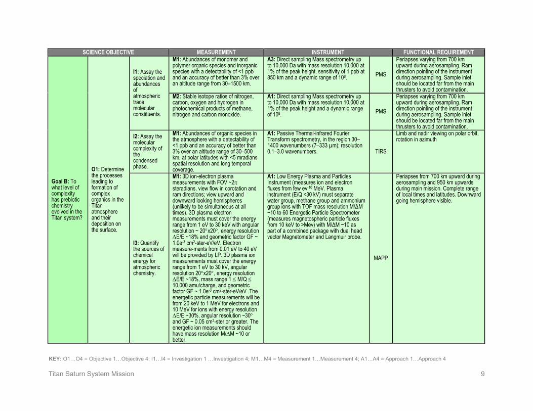
Titan Saturn System Mission 9
KEY: O1…O4 = Objective 1…Objective 4; I1…I4 = Investigation 1 …Investigation 4; M1…M4 = Measurement 1…Measurement 4; A1…A4 = Approach 1…Approach 4
SCIENCE OBJECTIVE MEASUREMENT INSTRUMENT FUNCTIONAL REQUIREMENT
Goal B: To what level of complexity has prebiotic chemistry evolved in the Titan system?
O1: Determine the processes leading to formation of complex organics in the Titan atmosphere and their deposition on the surface.
I1: Assay the speciation and abundances of atmospheric trace molecular constituents.
M1: Abundances of monomer and polymer organic species and inorganic species with a detectability of <1 ppb and an accuracy of better than 3% over an altitude range from 30–1500 km.
A3: Direct sampling Mass spectrometry up to 10,000 Da with mass resolution 10,000 at 1% of the peak height, sensitivity of 1 ppb at 850 km and a dynamic range of 108. PMS
Periapses varying from 700 km upward during aerosampling. Ram direction pointing of the instrument during aerosampling. Sample inlet should be located far from the main thrusters to avoid contamination.
M2: Stable isotope ratios of nitrogen, carbon, oxygen and hydrogen in photochemical products of methane, nitrogen and carbon monoxide.
A1: Direct sampling Mass spectrometry up to 10,000 Da with mass resolution 10,000 at 1% of the peak height and a dynamic range of 108. PMS
Periapses varying from 700 km upward during aerosampling. Ram direction pointing of the instrument during aerosampling. Sample inlet should be located far from the main thrusters to avoid contamination.
I2: Assay the molecular complexity of the condensed phase.
M1: Abundances of organic species in the atmosphere with a detectability of <1 ppb and an accuracy of better than 3% over an altitude range of 30–500 km, at polar latitudes with <5 mradians spatial resolution and long temporal coverage.
A1: Passive Thermal-infrared Fourier Transform spectrometry, in the region 30–1400 wavenumbers (7–333 µm); resolution 0.1–3.0 wavenumbers. TIRS
Limb and nadir viewing on polar orbit, rotation in azimuth
I3: Quantify the sources of chemical energy for atmospheric chemistry.
M1: 3D ion-electron plasma measurements with FOV ~2π steradians, view flow in corotation and ram directions; view upward and downward looking hemispheres (unlikely to be simultaneous at all times). 3D plasma electron measurements must cover the energy range from 1 eV to 30 keV with angular resolution ~ 20°x20°, energy resolution ΔE/E ~18% and geometric factor GF ~ 1.0e-3 cm2-ster-eV/eV. Electron measure-ments from 0.01 eV to 40 eV will be provided by LP. 3D plasma ion measurements must cover the energy range from 1 eV to 30 kV, angular resolution 20°x20°, energy resolution ΔE/E ~18%, mass range 1 ≤ M/Q ≤ 10,000 amu/charge, and geometric factor GF ~ 1.0e-3 cm2-ster-eV/eV .The energetic particle measurements will be from 20 keV to 1 MeV for electrons and 10 MeV for ions with energy resolution ΔE/E ~30%, angular resolution ~30° and GF ~ 0.05 cm2-ster or greater. The energetic ion measurements should have mass resolution M/ΔM ~10 or better.
A1: Low Energy Plasma and Particles Instrument (measures ion and electron fluxes from few ev-10 MeV. Plasma instrument (E/Q <30 kV) must separate water group, methane group and ammonium group ions with TOF mass resolution M/ΔM ~10 to 60 Energetic Particle Spectrometer (measures magnetospheric particle fluxes from 10 keV to >Mev) with M/ΔM ~10 as part of a combined package with dual head vector Magnetometer and Langmuir probe.
MAPP
Periapses from 700 km upward during aerosampling and 950 km upwards during main mission. Complete range of local times and latitudes. Downward going hemisphere visible.

Titan Saturn System Mission 10
KEY: O1…O4 = Objective 1…Objective 4; I1…I4 = Investigation 1 …Investigation 4; M1…M4 = Measurement 1…Measurement 4; A1…A4 = Approach 1…Approach 4
SCIENCE OBJECTIVE MEASUREMENT INSTRUMENT FUNCTIONAL REQUIREMENT
Goal B: To what level of complexity has prebiotic chemistry evolved in the Titan system?
O1: Determine the processes leading to formation of complex organics in the Titan atmosphere and their deposition on the surface.
I3: Quantify the sources of chemical energy for atmospheric chemistry.
M2: Thermal electron density and temperature from ionosphere peak upward.
A1: Langmuir (swept voltage/current) probe as part of combined package with Low Energy Plasma and Particles Instrument, Energetic Particle Spectrometer and dual vector magnetometer. (Note: to obtain implied vertical profile requires topside sounding using low frequency ionospheric sounder addition to TiPRA similar to MARSIS)
MAPP
Atmospheric sampling phase to get vertical profiles.
M3: Flux of UV photons. A1: : Modeled from swept voltage/current obtained by Langmuir probe (part of combined package)
MAPP Continuous measurements, globally distributed at varying altitudes
I4: Determine surface composition.
M1: Inventory organic and inorganic surface constituents at 250 m spatial resolution.
A1: Near-IR mapping spectroscopy within the atmospheric transmission windows from 0.85–2.4 µm and 4.8–5.8 µm with spectral resolution >400 and spatial resolution = 250 m.
HiRIS
Prefer mapping phase orbit within ±3 hrs from local noon
O2: Characterize the degree to which the Titan organic inventory is different from known abiotic organic material in meteorites.
I1: Assay the composition of organic deposits exposed at the surface, including dunes, lakes, seas.
M1: Inventory organic and inorganic surface constituents at 250 m spatial resolution.
A1: Near-IR mapping spectroscopy within the atmospheric transmission windows from 0.85–2.4 µm and 4.8–5.8 µm with spectral resolution >400 and spatial resolution = 250 m.
HiRIS
Prefer mapping phase orbit within ±3 hrs from local noon
O3: Characterize what chemical modification of organics occurs on the surface.
I1: Determine the roles of cratering and cryovolcanism in modification and hydrolysis of organics.
M1: Inventory organic species between +65 and -90 degrees latitude with 250 m spatial resolution and long temporal coverage.
A1: Repeated near-IR mapping spectroscopy within the 2- and 5-µm atmospheric-methane transmission windows (1.9–2.4 µm and 4.8–5.8 µm) with spectral resolution >400 and spatial resolution = 250 m.
HiRIS
Prefer mapping phase orbit within ±3 hrs from local noon
M2: Sounding profiles of subsurface dielectric horizons with 10 m vertical resolution and extensive surface coverage. Horizontal resolution required is 5–10 km cross track, 1 km lateral (along track) with 10 m vertical precision altimetry.
A1: Single band (>20 MHz center) penetrating radar with capability of sub-surface sounding to a depth of ~5 km with ~10 m depth resolution. TiPRA

Titan Saturn System Mission 11
KEY: O1…O4 = Objective 1…Objective 4; I1…I4 = Investigation 1 …Investigation 4; M1…M4 = Measurement 1…Measurement 4; A1…A4 = Approach 1…Approach 4
SCIENCE OBJECTIVE MEASUREMENT INSTRUMENT FUNCTIONAL REQUIREMENT
Goal B: To what level of complexity has prebiotic chemistry evolved in the Titan system?
O3: Characterize what chemical modification of organics occurs on the surface.
I2: Determine the importance of surface inorganic compounds as surface catalysts or doping agents.
M1: Identify inorganic salts and compounds containing phosphorous and other potentially reactive inorganic agents, from latitude 85°N to 85°S with 250 m spatial resolution and long temporal coverage.
A1: Partially completed with repeated near-IR mapping spectroscopy within the atmospheric transmission windows from 0.85–2.4 µm and 4.8–5.8 µm with spectral resolution >400 and spatial resolution = 250 m. HiRIS
Prefer mapping phase orbit within ±3 hrs from local noon
I3: Quantify the sources of energy for surface chemistry and identify the sites where it may have been present.
M1: Flux of cosmic rays. A1: Use star tracker to determine flux. M2: Distribution of impacts visible at the surface or buried as a result of erosional and depositional modification.
A1: High-resolution near-IR imaging at 2.05 ± 0.08 µm, 2.73 ± 0.08 µm, and 5.35 ± 0.45 µm.
HiRIS Prefer mapping phase orbit at ±4 hrs from local noon
A2: Single band (>20 MHz center) penetrating radar with capability of sub-surface sounding to a depth of ~5 km with ~10 m depth resolution.
TiPRA TiPRA can take data on the nightside.
M3: Map surface at 50 m resolution in multiple wavelengths and correlate morphology and spectral characteristics of surface features with topography.
A1: High-resolution near-IR imaging at 2.05 ± 0.08 µm, 2.73 ± 0.08 µm, and 5.35 ± 0.45 µm. HiRIS
Prefer mapping phase orbit at ±4 hrs from local noon
M4: Map compounds such as acetylene and polyacetylene that indicate sites of chemical energy from latitudes 85°N to 85°S with 250 m spatial resolution and long temporal coverage.
A1: Repeated near-IR mapping spectroscopy within the atmospheric transmission windows from 0.85–2.4 µm and 4.8–5.8 µm with spectral resolution >400 and spatial resolution = 250 m
HiRIS
Prefer mapping phase orbit within ±3 hrs from local noon
I4: Quantify the amount of aerosols deposited on Titan’s surface and their modification as they get buried.
M1: Sounding profiles of subsurface dielectric horizons with 10 m vertical resolution and extensive surface coverage. Horizontal resolution required is 5–10 km cross track, 1 km lateral (along track) with 10 m vertical precision altimetry.
A1: Single band (>20 MHz center) penetrating radar with capability of sub-surface sounding to a depth of ~5 km with ~10 m depth resolution.
TiPRA
TiPRA can take data on the nightside. Profiles coordinated with HiRIS data.
O4: Characterize the complexity of species in the subsurface ocean.
I1: Determine whether evidence of sub-surface ocean species is present in cryovolcanic sites.
M1: Map compounds such as ammonia, sulfates, and more complex organics (e.g., CH3COOH) at cryovolcanic sites with 250 m spatial resolution.
A1: Near-IR mapping spectroscopy within the atmospheric transmission windows from 0.85–2.4 µm and 4.8–5.8 µm with spectral resolution >400 and spatial resolution = 250 m. HiRIS
Prefer mapping phase orbit within ±3 hrs from local noon

Titan Saturn System Mission 12
KEY: O1…O4 = Objective 1…Objective 4; I1…I4 = Investigation 1 …Investigation 4; M1…M4 = Measurement 1…Measurement 4; A1…A4 = Approach 1…Approach 4
SCIENCE OBJECTIVE MEASUREMENT INSTRUMENT FUNCTIONAL REQUIREMENT
Goal B: To what level of complexity has prebiotic chemistry evolved in the Titan system?
O5: Characterize bulk composition, sources of nitrogen and methane, and exchange between the surface and the interior.
I1: Determine whether carbon dioxide is primarily internally derived or photo-chemically produced.
M1: Isotopic composition of surface carbon and oxygen species at 250 m resolution.
A1: Partially met with near-IR mapping spectroscopy within the atmospheric transmission windows from 0.85–2.4 µm and 4.8–5.8 µm with spectral resolution >400 and spatial resolution = 250 m.
HiRIS
Prefer mapping phase orbit within ±3 hrs from local noon
M2: Isotopic composition of atmospheric carbon and oxygen species from the surface to 1500 km.
A1: Mid-infrared spectra of the stratosphere with 30–1400 wave numbers (7–333 µm), spectral resolution of 0.1 to 3 wave numbers, spatial resolution of <5 mrad IFOV.
TIRS
Limb and nadir viewing on polar orbit, rotation in azimuth
A2: Submillimeter sounding at 540–640 GHz with resolution 300 khz and 5% precision in retrieved abundances.
SMS Limb viewing from polar orbit, in-track and off-track orientation
A3: Direct sampling Mass spectrometry up to 10,000 Da with mass resolution 10,000 at 1% peak height and dynamic range of 108. PMS
Periapses varying from 700 km upward during aerosampling. Ram direction pointing of the instrument during aerosampling. Sample inlet should be located far from the main thrusters to avoid contamination.
I2: Determine whether methane is primordial or derived from carbon dioxide.
M1: Isotopic composition of atmospheric carbon with precision of 0.1 per mil at altitudes from 600 km upwards (particularly in well mixed region below 850 km).
A1: Direct sampling Mass spectrometry with sensitivity of 10 ppb at 850 km altitude. A dual inlet system with a reference gas is required for accurate isotope determination. PMS
Periapses varying from 700 km upward during aerosampling. Ram direction pointing of the instrument during aerosampling. Sample inlet should be located far from the main thrusters to avoid contamination.
M2: Isotopic composition of surface carbon species at 250 m spatial resolution.
A1: Near-IR mapping spectroscopy within the atmospheric transmission windows from 0.85–2.4 µm and 4.8–5.8 µm with spectral resolution >400 and spatial resolution = 250 m.
HiRIS
Prefer mapping phase orbit within ±3 hrs from local noon
I3: Determine whether molecular nitrogen is derived from ammonia.
M1: Isotopic composition of atmospheric nitrogen from 600 km upwards to a precision of 0.1 per mil.
A1: Direct sampling Mass spectrometry with sensitivity of 10 ppb at 850 km altitude. A dual inlet system with a reference gas is required for accurate isotope determination. PMS
Periapses varying from 700 km upward during aerosampling. Ram direction pointing of the instrument during aerosampling. Sample inlet should be located far from the main thrusters to avoid contamination.
M2: Inventory compounds such as ammonia and ammonium hydrate between +65 and -90 degrees latitude with 250 m spatial resolution.
A1: Near-IR mapping spectroscopy within the atmospheric transmission windows from 0.85–2.4 µm and 4.8–5.8 µm with spectral resolution >400 and spatial resolution = 250 m.
HiRIS
Prefer mapping phase orbit within ±3 hrs from local noon

Titan Saturn System Mission 13
KEY: O1…O4 = Objective 1…Objective 4; I1…I4 = Investigation 1 …Investigation 4; M1…M4 = Measurement 1…Measurement 4; A1…A4 = Approach 1…Approach 4
SCIENCE OBJECTIVE MEASUREMENT INSTRUMENT FUNCTIONAL REQUIREMENT
Goal B: To what level of complexity has prebiotic chemistry evolved in the Titan system?
O5: Characterize bulk composition, sources of nitrogen and methane, and exchange between the surface and the interior.
I4: Determine whether pockets of partial melt are present at depth.
M1: Sounding profiles of subsurface dielectric horizons with 10 m vertical resolution and extensive surface coverage. Horizontal resolution required is 5–10 km cross track, 1 km lateral (along track) with 10 m vertical precision altimetry.
A1: Single band (>20 MHz center) penetrating radar with capability of sub-surface sounding to a depth of ~5 km with ~10 m depth resolution. TiPRA
TiPRA can take data on the nightside. Profiles coordinated with HiRIS data.
I5: Determine the isotopic ratios of noble gases’
M1: Quantify noble gas isotopic ratios (Ar, Kr, Xe)
A1: Direct sampling Mass spectrometry with sensitivity of 10 ppb at 850 km altitude. A dual inlet system with a reference gas is required for accurate isotope determination.
PMS Periapses varying from 700 km upward during aerosampling. Ram direction pointing of the instrument during aerosampling.
Goal C: What can be learned from Enceladus and from Saturn's magnetosphere about the origin and evolution of Titan?
Satu
rn M
agne
tosp
here
O1: Determine how Titan's atmosphere evolves by virtue of its coupling to the Saturn magneto-sphere and Titan's low gravity.
I1: Determine how energy is deposited in the upper atmosphere of Titan to drive the chemistry and the escape rate of major atmospheric constituents.
M1: 3D ion-electron plasma measurements with FOV ~2π steradians, view flow in corotation and ram directions; view upward and downward looking hemispheres (not likely to be simultaneous at all times). The 3D plasma electron measurements must cover the energy range from 1 eV to 30 keV with angular resolution ~20°x20°, energy resolution ΔE/E ~ 18% and geometric factor GF ~ 1.0e-3 cm2-ster-eV/eV. Electron measurements from 0.01 eV to 40 eV will be provided by LP. The 3D plasma ion measurements must cover the energy range from 0.1 V to 30 kV, angular resolution 20°x20°, energy resolution ΔE/E ~ 18%, mass range 1 ≤ M/Q ≤ 10,000 amu/charge, and geometric factor GF ~ 1.0e-3 cm2-ster-eV/eV (ability to attenuate GF desirable for ionospheric measurements. The hot plasma and energetic particle measurements will be from 20 keV to 1 MeV for electrons and 10 MeV for ions with energy resolution ΔE/E ~30%, angular resolution ~30° and GF ~ 0.05 cm2-ster or greater. The energetic ion measurements should have mass resolution M/ΔM ~10 or better.
A1: Measure ion and electron fluxes from few ev-10 MeV. Plasma instrument (E/Q <30 kV) must separate water group, methane group and ammonium group ions with TOF mass resolution M/ΔM ~10 (ST) and 60 (LEF). Energetic Particle Spectrometer (measures magnetospheric particle fluxes from 10 keV to >Mev) with M/ΔM ~ 10 as part of a combined package. The plasma instrument will need to measure the ion composition within Saturn’s magnetosphere with water group ions indicating an Enceladus source and nitrogen ions and methane ions indicating a Titan source. MAPP
Periapses from 700 km upward during aerosampling and 950 km upwards during main mission. Complete range of local times and latitudes. Downward and upward going hemispheres visible.

Titan Saturn System Mission 14
KEY: O1…O4 = Objective 1…Objective 4; I1…I4 = Investigation 1 …Investigation 4; M1…M4 = Measurement 1…Measurement 4; A1…A4 = Approach 1…Approach 4
SCIENCE OBJECTIVE MEASUREMENT INSTRUMENT FUNCTIONAL REQUIREMENT
Goal C: What can be learned from Enceladus and from Saturn's magnetosphere about the origin and evolution of Titan?
Satu
rn M
agne
tosp
here
O1: Determine how Titan's atmosphere evolves by virtue of its coupling to the Saturn magneto-sphere and Titan's low gravity.
I1: Determine how energy is deposited in the upper atmosphere of Titan to drive the chemistry and the escape rate of major atmospheric constituents.
M2: Thermal electron density and temperature in situ and density profiles as a function of altitude from the ionospheric peak to the orbiter.
A1: Langmuir (swept voltage/current) probe as part of combined packager. (Note: to obtain implied vertical profile requires topside sounding using low frequency ionospheric sounder addition to TiPRA [similar to MARSIS])
MAPP
Periapses from 700 km upward during aerosampling and 950 km upwards during main mission. Complete range of local times and latitudes.
M3: Abundances of upper atmospheric constituents with M up to 10,000 Da; mass resolution 10,000 at 1% of peak height at altitudes from 700 km through 1000 km; sensitivity including isotopes, detectability down to 0.01 ppb.
A1: Direct sampling Mass spectrometry up to 10,000 Da with mass resolution 10,000 at 1% peak height and dynamic range of 108. PMS
Ram direction pointing of the instrument during flybys. Sample inlet should be located far from the main thrusters to avoid contamination.
I2: Determine the escape rates and mechanisms of major atmospheric species on Titan.
M1: Vertical profiles of carbon, nitrogen and oxygen containing compounds as major and minor constituents near the exobase of Titan with accuracy better than 5%.
A1: Submillimeter sounding at 540–640 GHz with resolution 300 khz. SMS Limb viewing from polar orbit, in-track
and off-track orientation A2: Mid-infrared spectra of the stratosphere over the region 30–1400 wave numbers (7–333 µm), spectral resolution of 0.1 to 3 wave numbers, spatial resolution of <5 mrad IFOV.
TIRS
Limb and nadir viewing on polar orbit, rotation in azimuth
Ence
ladus
O2: Infer the crustal and deep internal structure of Enceladus, including the presence of gravity anomalies, and the moon's tidal history.
I1: Test for the presence of crustal or deeper structures associated with Enceladus' internal activity, including an interface between a solid crust and a liquid layer, as well as partial melt pockets
M1: Degree-two gravity coefficients (J2, C22, S22). Harmonic amplitudes down to 0.1 ppm Enceladus surface gravity.
A1: Relative velocity between the spacecraft and ground station determined from Doppler tracking with an accuracy up to 50 µm/s with 60 s integration periods. (Ka-band link stability ~10–15 after all calibrations including accelerometer for non-gravitational forces).
RSA
Optimized gravity configuration near closest approach with minimized non-gravitational forces as well as Doppler tracking over long arcs.
M2: Sounding profiles of subsurface dielectric horizons, in the active region, up to 50 km depth at 100 m vertical resolution and a spatial resolution better than 2 km.
A1: Single band (>20 MHz center) penetrating radar and altimetry with capability of sub-surface sounding to a depth of ~50 km with ~10 m depth resolution.
TiPRA
Observations at C/A for all flybys. Use long radar echo gate in order to receive echoes from greater penetration depths. Simultaneous observation with RSA to obtain both the subsurface structure and associated gravity signature.
I2: Test for true polar wander on Enceladus.
M1: Obliquity and spin of Enceladus. A1: Repeated high resolution near-IR imaging at 2.05 ± 0.08 µm, 2.73 ± 0.08 µm, and 5.35 ± 0.45 µm. HiRIS
Acquired ~600 km from Enceladus. Repeated on multiple passes.

Titan Saturn System Mission 15
KEY: O1…O4 = Objective 1…Objective 4; I1…I4 = Investigation 1 …Investigation 4; M1…M4 = Measurement 1…Measurement 4; A1…A4 = Approach 1…Approach 4
SCIENCE OBJECTIVE MEASUREMENT INSTRUMENT FUNCTIONAL REQUIREMENT
Goal C: What can be learned from Enceladus and Saturn's magnetosphere about the origin and evolution of Titan?
Ence
ladus
O3: Characterize the chemistry of the Enceladus plumes.
I1: Determine the composition of the plume, including isotopic abundances.
M1: Abundances and time variability of organic and inorganic species in the plume, including heavy polymers at mass resolution 10,000 at 1% of peak height.
A1: Direct sampling Mass spectrometry up to 10,000 Da with mass resolution 10,000 at 1% peak height and dynamic range of 108.
PMS
Ram direction pointing of the instrument during flybys. Sample inlet should be located far from the main thrusters to avoid contamination. High Data Volume Data Rate: 48 kbits/s
A2 Submillimeter sounding at 540–640 GHz with resolution 300 khz. SMS Map plumes
O4: Understand the formation of the active region near the south pole, and whether liquid water exists beneath the area.
I1: Characterize the global and regional geo-morphology of Enceladus’ surface.
M1: Map surface features at 0.5 km spatial resolution at the global scale.
A1: Whole-disk near-IR imaging at 2.05 ± 0.08 µm, 2.73 ± 0.08 µm, and 5.35 ± 0.45 µm.
HiRIS Acquired ~15,000 km from Enceladus
M2: Composition of surface at 1 km spatial resolution at the global scale.
A1: Near-IR mapping spectroscopy from 0.85–2.4 µm and 4.8–5.8 µm with spectral resolution >400.
HiRIS Acquired ~6,000 km from Enceladus
M3: Map surface features at 30 m spatial resolution of candidate locations on a regional scale.
A1: High-resolution Near-IR imaging at 2.05 ± 0.08 µm, 2.73 ± 0.08 µm, and 5.35 ± 0.45 µm.
HiRIS Acquired ~1000 km from Enceladus
M4: Surface topography at 10 m vertical resolution, a spatial resolution along-track up to 100 m, and cross-track up to 1 km of candidate locations on a regional scale.
A1: Single band (>20 MHz center) penetrating radar and altimetry with capability of sub-surface sounding to a depth of ~50 km with ~10 m depth resolution.
TiPRA
Observations at C/A for all flybys. Simultaneous observation with RSA to obtain both the subsurface structure and associated gravity signature.
M5: Composition of surface geologic features at 300 m spatial resolution of candidates locations on a regional scale.
A1: Near-IR mapping spectroscopy from 0.85–2.4 µm and 4.8–5.8 µm with spectral resolution >400. HiRIS
Acquired ~1,800 km from Enceladus
M6: Sounding profiles of subsurface dielectric horizons, in the active region up to 50 km depth, at 10 m vertical resolution, a spatial resolution along-track up to 0.1 km and cross-track up to 1 km.
A1: Single band (>20 MHz center) penetrating radar and altimetry with capability of sub-surface sounding to a depth of ~50 km with ~10 m depth resolution.
TiPRA
Observations at C/A for all flybys. Use long radar echo gate in order to receive echoes from greater penetration depths Simultaneous observation with RSA to obtain both the subsurface structure and associated gravity signature.
I2: Determine whether thermal anomalies exist underneath the surface.
M1: Surface temperature distribution with precision 1 K; spatial resolution 100 meters.
A1: Mid-infrared spectra of the surface in the 30–1400 wave numbers (7–333 µm) region, spectral resolution of 3 to 15 wave numbers, spatial resolution of <5 mrad IFOV.
TIRS
Nadir viewing of the surface, range less than 600 km
M2: Sounding profiles of subsurface dielectric horizons, in the active region up to 50 km depth
A1: Single band (>20 MHz center) penetrating radar and altimetry with capability of sub-surface sounding to a depth of ~50 km with ~10 m depth resolution.
TiPRA
Observations at C/A for all flybys. Use long radar echo gate in order to receive echoes from greater penetration depths Simultaneous observation with RSA to obtain both the subsurface structure and associated gravity signature.

Titan Saturn System Mission 16
KEY: O1…O4 = Objective 1…Objective 4; I1…I4 = Investigation 1 …Investigation 4; M1…M4 = Measurement 1…Measurement 4; A1…A4 = Approach 1…Approach 4
SCIENCE OBJECTIVE MEASUREMENT INSTRUMENT FUNCTIONAL REQUIREMENT
Goal C: What can be learned from Enceladus and Saturn's magnetosphere about the origin and evolution of Titan?
Ence
ladus
O4: Understand the formation of the active region near the south pole, and whether liquid water exists beneath the area.
I3: Determine the origin of the surface organic materials and its connection with interior reservoirs.
M1: Gravity field amplitude down to 0.1 ppm Enceladus surface gravity.
A1: Relative velocity between the spacecraft and ground station determined from Doppler tracking with an accuracy up to 50 µm/s with 60 s integration periods. (Ka-band link stability ~10–15 after all calibrations including accelerometer for non-gravitational forces).
RSA
Optimized gravity configuration near closest approach with minimized non-gravitational forces
M2: Composition of surface organics at 300 m spatial resolution.
A1: Near-IR mapping spectroscopy from 0.85–2.4 µm and 4.8–5.8 µm with spectral resolution >400. HiRIS
Acquired ~1,800 km from Enceladus
O5: Identify and characterize candidate sites on Enceladus for future in situ exploration.
I1: Determine whether extrusion of water ice or liquid water has occurred recently.
M1: Distribution of water ice and frost at 300 m spatial resolution.
A1: Near-IR mapping spectroscopy from 0.85–2.4 µm and 4.8–5.8 µm with spectral resolution >400.
HiRIS Acquired ~1,800 km from Enceladus
M2: Sounding profiles of subsurface dielectric horizons, in the active region, up to 50 km depth at 10 m vertical resolution, a spatial resolution along-track up to 0.1 km and cross-track up to 1 km.
A1: Single band (>20 MHz center) penetrating radar and altimetry with capability of sub-surface sounding to a depth of ~50 km with ~10 m depth resolution.
TiPRA
Observations at C/A for all flybys. Use long radar echo gate in order to receive echoes from greater penetration depths Simultaneous observation with RSA to obtain both the subsurface structure and associated gravity signature.
M3: Surface temperature distribution with precision 1 K; spatial resolution 100 meters.
A1: Mid-infrared spectra of the stratosphere in the 30–1400 wave numbers (7–333 µm) region, spectral resolution of 3 to 15 wave numbers, spatial resolution of <5 mrad IFOV.
TIRS
Nadir viewing of the surface, range less than 600 km
I2: Determine whether areas of extremely thin crust or exposed liquid within cracks exist.
M1: Variations in the tiger stripe regions as a function of true anomaly at 30 m spatial resolution.
A1: High-resolution near-IR imaging at 2.05 ± 0.08 µm, 2.73 ± 0.08 µm, and/or 5.35 ± 0.45 µm repeated at multiple true anomalies.
HiRIS Acquired ~1000 km from Enceladus. Requires multiple flybys over the south polar region.
M2: Gravity field amplitude down to 0.1 ppm Enceladus surface gravity at candidate locations. Repeat coverage for different true anomalies.
A1: Relative velocity between the spacecraft and ground station determined from Doppler tracking with an accuracy up to 50 µm/s with 60 s integration periods. (Ka-band link stability ~10–15 after all calibrations including accelerometer for non-gravitational forces).
RSA
Optimized gravity configuration near closest approach with minimized non-gravitational forces, as well as Doppler tracking over long arcs.
M3: Sounding profiles of subsurface dielectric horizons, in the active region, up to 50 km depth at 10 m vertical resolution, a spatial resolution along-track up to 0.1 km and cross-track up to 1 km.
A1: Single band (>20 MHz center) penetrating radar and altimetry with capability of sub-surface sounding to a depth of ~50 km with ~10 m depth resolution.
TiPRA
Observations at C/A for all flybys. Use long radar echo gate in order to receive echoes from greater penetration depths Simultaneous observation with RSA to obtain both the subsurface structure and associated gravity signature.
M4: Surface temperature distribution with precision 1 K; spatial resolution 100 meters.
A1: Mid-infrared spectra of the stratosphere in the 30–1400 wave numbers (7–333 µm) region, spectral resolution of 3 to 15 wave numbers, spatial resolution of <5 mrad IFOV.
TIRS
Nadir viewing of the surface, range less than 600 km

Titan Saturn System Mission 17
KEY: O1…O4 = Objective 1…Objective 4; I1…I4 = Investigation 1 …Investigation 4; M1…M4 = Measurement 1…Measurement 4; A1…A4 = Approach 1…Approach 4
Table 1-2. Science Traceability Matrix—Montgolfière SCIENCE OBJECTIVE MEASUREMENT INSTRUMENT MISSION REQUIREMENTS
Goal A: How does Titan function as a system; to what extent are there similarities and differences with Earth and other solar system bodies?
O2: Characterize the relative importance of exogenic and endogenic oxygen sources.
I1: Quantify the flux of exospheric oxygen into the atmosphere.
M3: O content of the aerosols
A1: In situ analysis of the aerosols collected at the level of the montgolfière
TMCA Collect aerosols that are falling from higher altitudes; 1 km and 5° attitude knowledge of montgolfière.
M4: Amount of O bearing molecules in the troposphere
A1: Infrared spectra of the atmosphere, including CO and CO2
BIS Adapt the observation strategy to the motion of the montgolfière. Coordination with VISTA-B for context is required.
I2: Quantify the flux of endogenic oxygen from the surface and interior.
M1: Inventory of surface constituents containing oxygen, including major isotopologues at 250 m or better resolution
A2: Infrared spectral maps of the surface at wavelengths absorbed by the O bearing molecules (4.92 µm for CO2) at 10% level within a pixel
BIS
Adapt the observation strategy to the motion of the montgolfière. Coordination with VISTA-B for context is required.
O3: Characterize the major processes controlling the global distribution of atmospheric chemical constituents.
I1: Characterize the major chemical cycles.
M1: Vertical, latitudinal, and temporal dependence of condensed and gaseous species in the atmosphere from 0 to 1500 km with precision better than 10%
A5: Pump the atmosphere into the chemical analyzer to analyze ethane mole fraction and other volatile species in troposphere (gas and condensed phase), with a precision of 5%
TMCA
Tracking of the montgolfière (lat, long, alt); 1 km and 5°attitude knowledge required.
I2: Determine the relative importance of global transport.
M3: Ethane mole fraction in the troposphere (gas and condensed phases) at different longitudes (day/night variations); ethane/methane
A1: Pump the atmosphere into the chemical analyzer to analyze ethane mole fraction in troposphere (gas and condensed phase), with a precision of 5%
TMCA
Tracking of the montgolfière (lat, long, alt); 1 km and 5° attitude knowledge of montgolfière
O4: Characterize the atmospheric circulation and flow of energy.
I1: Determine the atmospheric thermal and dynamical state.
M5: Track the drift of the montgolfière to infer strength and directions of winds.
A1: The location of the montgolfière relative to Titan by tri-axial accelerometers and gyroscopes (inertial platform) to infer wind field and gusts.
ASI/ MET
ASI should be placed as close as possible to the center of gravity of the gondola. 1 km and 5° attitude knowledge of montgolfière.
M6: Measure deposition of sunlight as a function of altitude to infer the radiation balance in the troposphere.
A1: Solar light arriving at the altitude of the montgolfière during its journey in the tropical regions
BIS
Adapt the observation strategy to the motion of the montgolfière. Coordination with VISTA-B for context is required. 1 km and 5° attitude knowledge of montgolfière.

Titan Saturn System Mission 18
KEY: O1…O4 = Objective 1…Objective 4; I1…I4 = Investigation 1 …Investigation 4; M1…M4 = Measurement 1…Measurement 4; A1…A4 = Approach 1…Approach 4
SCIENCE OBJECTIVE MEASUREMENT INSTRUMENT MISSION REQUIREMENTS
Goal A: How does Titan function as a system; to what extent are there similarities and differences with Earth and other solar system bodies?
O4: Characterize the atmospheric circulation and flow of energy.
I1: Determine the atmospheric thermal and dynamical state.
M7: Vertical profile of temperature, pressure, and density (T and P accuracy to 0.1 K and 1 mPa and resolution to 0.02 K and 0.1% respectively). Determine the trajectory of the montgolfière during entry and descent and floating phase
A1: Measure T by a Pt wire resistance thermometer and P by Kiel probe and capacitive gauges. Pressure and temperature measurements during the descent. Monitor meteorological conditions during the montgolfière journey
ASI/ MET
ASI pressure inlet and thermometers should have access to the atmospheric unperturbed flow (outside the descent probe boundary layer). The trajectory of the probe (entry and descent module reconstructed from the engineering sensor data (e.g., IMU), the high sensitive scientific accelerometer (and/or IMU). Coordination with orbiter RSA data.
A2: Three-axis in situ accelerometer measurements to a precision of 10-5 m/s2 during entry and during the montgolfière journey
ASI/ MET
ASI-ACC should be placed as close as possible to the entry module CoG. ASI operating before nominal interface entry altitude (1270 km). Coordination with orbiter RSA data.
M8: Pressure, temperature variations in space and time (T and P accuracy to 0.1 K and 1 mPa and resolution to 0.02 K and 0.1% respectively)
A1: Pressure, temperature, and accelerometry during the journey of the montgolfière ASI/
MET
1 km and 5° attitude knowledge of montgolfière.
M9: Determine large surface temperature
A1: Infrared spectra of the surface between 5 and 5.6 µm will enable us to see T variations larger than 50 K.
BIS
Adapt the observation strategy to the motion of the montgolfière. Coordination with VISTA-B for context is required.
M10: Timing (local time, orbital phase) of cloud occurrence, evolution, cloud base/top and appearance
A1: Continuous monitoring of cloud formation
VISTA-B
1 km and 5° attitude knowledge of montgolfière required.
A2: Continuous monitoring of meteorological conditions
ASI/ MET
1 km and 5° attitude knowledge of montgolfière
I2: Determine the impact of haze and clouds.
M4: Track the motion of clouds (and cryovolcanic vents, if any). Search for orographic clouds.
A1: Imaging from the gondola at 10 m resolution
VISTA-B
1 km and 5° attitude knowledge of montgolfière
A2: Infrared spectral maps of the clouds and terrain
BIS Adapt the observation strategy to the motion of the montgolfière. Coordination with VISTA-B for context is required.

Titan Saturn System Mission 19
KEY: O1…O4 = Objective 1…Objective 4; I1…I4 = Investigation 1 …Investigation 4; M1…M4 = Measurement 1…Measurement 4; A1…A4 = Approach 1…Approach 4
SCIENCE OBJECTIVE MEASUREMENT INSTRUMENT MISSION REQUIREMENTS
Goal A: How does Titan function as a system; to what extent are there similarities and differences with Earth and other solar system bodies?
O4: Characterize the atmospheric circulation and flow of energy.
I2: Determine the impact of haze and clouds.
M5: Particle size distribution and optical properties of clouds and haze
A1: Infrared measurements of reflective light BIS
Adapt the observation strategy to the motion of the montgolfière. Coordination with VISTA-B for context is required.
M6: Profile of methane mole fraction and its variations in the equatorial regions; fraction of methane in the condensed phase compared to the total atmospheric methane abundance
A1: Infrared spectral maps to measure the width of the methane absorption bands to determine the amount of methane
BIS
Adapt the observation strategy to the motion of the montgolfière. Coordination with VISTA-B for context is required.
A2: Pump the atmosphere into the chemical analyzer to analyze methane mole fraction in troposphere (gas and condensed phase), with a precision of 1%
TMCA
Tracking of the montgolfière (lat, long, alt); 1 km and 5° attitude knowledge required.
A3: In situ monitoring of T and P conditions. Simultaneous measurements of pressure and T are necessary to assess the phase of the species (e.g., condensation) and to associate a certain pressure level in the atmosphere (or equivalent altitude level) to the mole fractions determined by TMCA.
ASI/ MET
1 km and 5° attitude knowledge of montgolfière
I3: Determine the effects of atmospheric composition.
M3: Profile of ethane mole fraction and its variations in the equatorial regions; fraction of ethane in the condensed phase compared to the total atmospheric ethane abundance
A1: Infrared spectral maps to measure the width of the ethane absorption bands to determine the amount of ethane
BIS
Adapt the observation strategy to the motion of the montgolfière. Coordination with VISTA-B for context is required.

Titan Saturn System Mission 20
KEY: O1…O4 = Objective 1…Objective 4; I1…I4 = Investigation 1 …Investigation 4; M1…M4 = Measurement 1…Measurement 4; A1…A4 = Approach 1…Approach 4
SCIENCE OBJECTIVE MEASUREMENT INSTRUMENT MISSION REQUIREMENTS
Goal A: How does Titan function as a system; to what extent are there similarities and differences with Earth and other solar system bodies?
O4: Characterize the atmospheric circulation and flow of energy.
I3: Determine the effects of atmospheric composition.
M3: Profile of ethane mole fraction and its variations in the equatorial regions; fraction of ethane in the condensed phase compared to the total atmospheric ethane abundance
A2: Pump the atmosphere into the chemical analyzer to analyze ethane mole fraction in troposphere (gas and condensed phase), with a precision of 1%
TMCA
Tracking of the montgolfière (lat, long, alt); 1 km and 5° attitude knowledge required.
A3: In situ monitoring of T and P conditions Simultaneous measurements of pressure and T are necessary to assess the phase of the species (e.g., condensation) and to associate a certain pressure level in the atmosphere (or equivalent altitude level) to the mole fractions determined by TMCA.
ASI/ MET
1 km and 5° attitude knowledge of montgolfière.
M4: Determine the topography and find correlation with clouds and turbulences.
A1: Topography and clouds are determined by the stereo imaging
VISTA-B
1 km and 5° attitude knowledge of montgolfière
A2: Topography is determined by first echo of the radar sounder
TRS Precise identification of the trajectory of the montgolfière increases the quality of the measurements; 1 km and 5° attitude knowledge required.
A3: Infrared spectrometry to monitor the clouds
BIS Adapt the observation strategy to the motion of the montgolfière. Coordination with VISTA-B for context
A4: In situ monitoring of meteorological conditions (T, P, and wind) to investigate thermal variations, turbulence and dynamics (e.g., gravity waves and tides)
ASI/ MET
1 km and 5° attitude knowledge of montgolfière.
I4: Determine the effects of surface processes on meteorology.
M4: Identify active volcanism in the equatorial region with 50 m resolution from orbit and .2.5 m resolution from 10km altitude
A1: Infrared spectral maps BIS Adapt the observation strategy to the motion of the montgolfière.
Coordination with VISTA-B for context A2: Stereo and high-res imaging from the Gondola VISTA
-B
1 km and 5° attitude knowledge requirement of montgolfière

Titan Saturn System Mission 21
KEY: O1…O4 = Objective 1…Objective 4; I1…I4 = Investigation 1 …Investigation 4; M1…M4 = Measurement 1…Measurement 4; A1…A4 = Approach 1…Approach 4
SCIENCE OBJECTIVE MEASUREMENT INSTRUMENT MISSION REQUIREMENTS
Goal A: How does Titan function as a system; to what extent are there similarities and differences with Earth and other solar system bodies?
O4: Characterize the atmospheric circulation and flow of energy.
I4: Determine the effects of surface processes on meteorology.
M6: Search for possible surface methane sources (vents, etc.) in the equatorial regions.
A1: Stereo and high-res imaging from the Gondola
VISTA-B
1 km and 5° attitude knowledge of montgolfière
A2: Monitor atmospheric methane concentration. TMCA Precise location of montgolfière to 1 km and 5° attitude knowledge.
A3: In situ monitoring of meteorological conditions by direct T and P measurements (T and P accuracy to 0.1 K and 1 mPa and resolution to 0.02 K and 0.1% respectively) and gondola attitude
ASI/ MET
Precise location of montgolfière to 1 km and 5° attitude knowledge.
A4: Infrared spectral maps to measure the width of the methane absorption bands to determine the amount of methane
BIS
Adapt the observation strategy to the motion of the montgolfière. Coordination with VISTA-B for context
M7: Global distribution of surface wind directions
A1: Direction of dunes/cloud movement
VISTA-B
Precise location of montgolfière to 1 km and 5° attitude knowledge .
A2: Wind field inferred from T and P measurements (T and P accuracy to 0.1 K and 1 mPa and resolution to 0.02 K and 0.1% respectively) and monitoring the gondola attitude
AS/ MET
Wind field inferred from T and P measurements and monitoring the gondola attitude; 1 km and 5° attitude knowledge requirement of montgolfière
I5: Determine the exchange of momentum, energy and matter between the surface and atmosphere and characterize the planetary boundary layer.
M6: Global distribution of surface roughness and topography
A1: Radar measurements TRS Precise location of montgolfière—1 km and 5° attitude knowledge
required. A2: Stereo imaging (10 m/pix)
VISTA-B
Precise location of montgolfière—1 km and 5° attitude knowledge required.
A3: Measure the shadows of reliefs within the infrared maps
BIS Adapt the observation strategy to the motion of the montgolfière. Coordination with VISTA-B for context is required.
M7: Diurnal temperature variations and time-series meteorology
A1: Measure the temperature by a Pt wire resistance thermometer with ΔT = 0.1 K
ASI/ MET
Same as ASI/MET above

Titan Saturn System Mission 22
KEY: O1…O4 = Objective 1…Objective 4; I1…I4 = Investigation 1 …Investigation 4; M1…M4 = Measurement 1…Measurement 4; A1…A4 = Approach 1…Approach 4
SCIENCE OBJECTIVE MEASUREMENT INSTRUMENT MISSION REQUIREMENTS
Goal A: How does Titan function as a system; to what extent are there similarities and differences with Earth and other solar system bodies?
O4: Characterize the atmospheric circulation and flow of energy.
I5: Determine the exchange of momentum, energy and matter between the surface and atmosphere and characterize the planetary boundary layer.
M8: Distribution of condensates at the surface
A1: Infrared identification of condensate species BIS Adapt the observation strategy to the motion of the montgolfière.
Coordination with VISTA-B for context is required. A2: High spatial resolution color images of the surface at equatorial latitudes; ground truth for orbiter measurement
VISTA-B
Precise location of montgolfière to 1 km and 5° attitude knowledge of montgolfière
M9: Abundance of water ice at the surface
A1: Infrared mapping through the methane windows and compare windows where ice absorbs (e.g., 1.6 and 2.0 µm) and where it does not (1.05 µm).
BIS
Adapt the observation strategy to the motion of the montgolfière. Coordination with VISTA-B for context is required.
I6: Determine the connection between weather, ionosphere, and electricity.
M2: Global electric circuit and fair-weather electric field in the range from 0–10 kHz. With a height resolution of 1 km
A1: Measurement of electric field using dipole antennas; vertical and horizontal electric field in the frequency range from DC to VLF (~10 kHz)
TEEP-B
1 km and 5° attitude knowledge of montgolfière
M3: Extra low and low frequency (ELF-VLF) magnetic components of the atmospheric electricity from 0–10 kHz
A1: Measurement of magnetic field using loop antenna; vertical and horizontal electric field in the frequency range from DC to VLF (~10 kHz nas or search coils)
TEEP-B
1 km and 5° attitude knowledge of montgolfière
M4: Search for electric discharges.
A1: Long exposure nighttime imaging
VISTA-B
Precise location of montgolfière from Inertial Navigation System (INS); 1 km requirement
A2: Electric field and optical sensors
TEEP-B
Coordinated with VISTA-B
M5: Electrical conductivity and permittivity of the atmosphere (positive and negative ions + electrons) to 1 km resolution in the range 10-14 to 10-6 Sm-1 and electrons only, with a height resolution to 100 m in the range 10-11 to 10-6 Sm-1
A1: Relaxation probe to measure the conductivity of all charged species
TEEP-B
Time series of conductivity (all charged species)
A2: Mutual impedance probe which measures the conductivity of electronics only
TEEP-B
Amplitude and phase of electric signal

Titan Saturn System Mission 23
KEY: O1…O4 = Objective 1…Objective 4; I1…I4 = Investigation 1 …Investigation 4; M1…M4 = Measurement 1…Measurement 4; A1…A4 = Approach 1…Approach 4
SCIENCE OBJECTIVE MEASUREMENT INSTRUMENT MISSION REQUIREMENTS
Goal A: How does Titan function as a system; to what extent are there similarities and differences with Earth and other solar system bodies?
O5: Characterize the amount of liquid on the Titan surface today.
I3: Determine surface composition that might reveal the presence of liquids.
M1: Optical maps in the methane windows at 2.5 m resolution
A1: Use the infrared images at different incidence angles to determine the nature of the surface (liquid or solid)
BIS
Adapt the observation strategy to the motion of the montgolfière. Coordination with VISTA-B for context is required.
M2: Precipitation rate, solid or liquid nature of precipitation
A1: In situ monitoring of T and P conditions with reference to the altitude level
ASI/ MET
1 km and 5° attitude knowledge of montgolfière
A3: In situ observations at all wavelengths.
VISTA-B
Precise location of montgolfière to 1 km and 5° attitude knowledge of montgolfière
I4: Determine the nature of precipitation responsible for the formation of valley networks in the tropical regions.
M1: Lateral variations of surface compounds in the valley networks at 5 m resolution
A1: Map lateral variations of surface composition in the river networks and at their mouth
BIS
Adapt the observation strategy to the motion of the montgolfière. Coordination with VISTA-B for context is required.
A3: High spatial resolution color images of the surface at equatorial latitudes; ground truth for orbiter measurement
VISTA-B
Precise location of montgolfière to 1 km and 5° attitude knowledge.
O6: Characterize the major processes transforming the surface throughout time.
I1: Determine the origin of major crustal features; correlate regional elevation changes with geomorph-ology and compositional variations.
M5: Measure regional topography
A1: Stereo images of the surface
VISTA-B
Precise location of montgolfière to 1 km and 5° attitude knowledge. .
A2: Reflection of radar signal
TRS
Precise identification of the trajectory of the montgolfière increases the quality of the measurements
I2: Characterize the origin of major surface features, including the effects of liquid flow, tectonic, volcanic, and impact events.
M4: Geological maps at 2.5 m resolution
A1: Infrared mapping through the methane windows
BIS
Adapt the observation strategy to the motion of the montgolfière. Coordination with VISTA-B for context is required.
I3: Determine the internal magnetic signal.
M1: Magnetic map, taken from a constant altitude
A1: Dual sensor magnetometer fixed to boom on gondola MAG
Precise location of montgolfière to 1 km and 5° attitude knowledge 1 km continuous magnetic field data, as much coverage of the surface as possible. Consideration of magnetic cleanliness requirements vs. boom length. Complementarities with orbiter measurements during Titan flybys.

Titan Saturn System Mission 24
KEY: O1…O4 = Objective 1…Objective 4; I1…I4 = Investigation 1 …Investigation 4; M1…M4 = Measurement 1…Measurement 4; A1…A4 = Approach 1…Approach 4
SCIENCE OBJECTIVE MEASUREMENT INSTRUMENT MISSION REQUIREMENTS
Goal A: How does Titan function as a system; to what extent are there similarities and differences with Earth and other solar system bodies?
O6: Characterize the major processes transforming the surface throughout time.
I4: Detect and measure the depth of shallow subsurface reservoirs of liquid (hydrocarbons).
M2: Subsurface sounding at frequency between 150 and 200 MHz in order to detect liquid reservoirs less than 1 km deep.
A1: High resolution subsurface profiles over few hundred meters (500 m) spot size and vertical resolution <6 m
TRS
Precise location of the montgolfière makes it possible an integrated multiscale analysis of the TRS profiles with the radar measurements acquired by the sounder on the orbiter. Precise location of montgolfière to 1 km and 5° attitude knowledge.
I5: Determine the subsurface structures and constrain the stratigraphic history of dunes.
M1: Subsurface sounding along the montgolfière journey at a frequency between 150 and 200 MHz (vertical resolution of less than 10 meters and spatial resolution less than 200 meters)
A1: Radar sounding
TRS
Comparison between optical remote sensing images and radar profiles. Precise location of the montgolfière makes it possible an integrated multiscale analysis of the TRS profiles with the radar measurements acquired by the sounder on the orbiter. Precise location of montgolfière to 1 km and 5° attitude knowledge.
O7: Determine the existence of a subsurface liquid water ocean.
I2: Determine if the crust is decoupled from the interior and the thickness and rigidity of the icy crust.
M1: Map of geological structures at different true anomalies
A1: High-resolution mapping of surface features with their precise location VISTA
-B
Precise location of montgolfière to 1 km and 5° attitude knowledge.
I3: Determine the induced magnetic field signatures in order to confirm subsurface liquid and place constraints on the conductivity and depth of the liquid
M3: In situ vector magnetic field measurements
A1: Dual sensor magnetometer fixed to boom on gondola
MAG
Precise location of montgolfière to 1 km and 5° attitude knowledge. Continuous magnetic field data combined with magnetic field measurements from the orbiter and lander. Nightside data at 0600 Saturn Local Time highly desirable. Desirable (not required) to have some measurements with the lander, montgolfière, and orbiter in a line radiating from Saturn.

Titan Saturn System Mission 25
KEY: O1…O4 = Objective 1…Objective 4; I1…I4 = Investigation 1 …Investigation 4; M1…M4 = Measurement 1…Measurement 4; A1…A4 = Approach 1…Approach 4
SCIENCE OBJECTIVE MEASUREMENT INSTRUMENT MISSION REQUIREMENTS
Goal A: How does Titan function as a system; to what extent are there similarities and differences with Earth and other solar system bodies?
O8: Determine the state of internal differentiation, whether Titan has a metal core and an intrinsic magnetic field, and constrain the crustal expression of thermal evolution of Titan’s interior.
I2: Determine whether Titan has a dynamo.
M2: In situ vector magnetic field measurements
A1: Dual sensor magnetometer fixed to boom on gondola MAG
Precise location of montgolfière to 1 km and 5° attitude knowledge. Continuous magnetic field data combined with magnetic field measurements from the orbiter and lander. Nightside data at 0600 Saturn Local Time highly desirable. Desirable (not required) to have some measurements with the lander, montgolfière, and orbiter in a line radiating from Saturn.
I3: Quantify exchange between interior and atmosphere.
M3: Measure noble gases and isotopes (esp., Ar, Kr, Xe) to ppb levels in gas phase and aerosols
A1: In situ measurement of aerosols and atmospheric gas phase, with a precision of 1%
TMCA
Good location to 1 km and 5° attitude knowledge of montgolfière
M4: Subsurface layering
A1: High resolution subsurface profiles over few hundred meters (500 m) spot size and vertical resolution <6 m
TRS
Precise location of the montgolfière to integrate multiscale analysis of the TRS profiles with the radar measurements acquired by the sounder on the orbiter; 1 km and 5° attitude knowledge of montgolfière
Goal B: To what level of complexity has prebiotic chemistry evolved in the Titan system?
O1: Determine the chemical pathways leading to formation of complex organics at all altitudes in the Titan atmosphere and their deposition on the surface.
I1: Assay the speciation and abundance of atmospheric trace molecular constituents.
M4: Concentration of molecular constituents in the troposphere with S/N ratio >100
A1: IR reflectance spectra with long integration times to enable spectral summing over homogeneous regions.
BIS
Adapt the observation strategy to the motion of the montgolfière. Coordination with VISTA-B for context is required.
M5: Latitudinal and vertical distribution of minor species and its temporal variation
A1: In situ analysis of minor species TMCA
Same location of the montgolfière at different times; analysis of only low molecular mass species
M6: Day-night variation of minor species to infer information about condensation
A1: In situ analysis of minor species gas and condensed phase TMCA
Same location of the montgolfière during at least one full Titan day
M7: Monitor T and P conditions to help determine species abundances and condensation.
A1: In situ measurements of T and P with reference to the altitude level. Simultaneous measurements of P and T are necessary to assess the phase of the species (e.g., condensation) and to associate a certain pressure level in the atmosphere (or equivalent altitude level) to the mole fractions determined by TMCA.
ASI/ MET
1 km and 5° attitude knowledge of montgolfière.

Titan Saturn System Mission 26
KEY: O1…O4 = Objective 1…Objective 4; I1…I4 = Investigation 1 …Investigation 4; M1…M4 = Measurement 1…Measurement 4; A1…A4 = Approach 1…Approach 4
SCIENCE OBJECTIVE MEASUREMENT INSTRUMENT MISSION REQUIREMENTS
Goal B: To what level of complexity has prebiotic chemistry evolved in the Titan system?
O1: Determine the chemical pathways leading to formation of complex organics at all altitudes in the Titan atmosphere and their deposition on the surface.
I2: Assay the molecular complexity of the condensed phase.
M2: Chemical composition (elemental, molecular isotopic, and chiral) of aerosols
A1: Collect aerosols during their descent to the surface TMCA
1 km and 5° attitude knowledge of montgolfière
M3: Chemical abundance of gases in troposphere
A1: In situ analysis of major and minor species TMCA
1 km and 5° attitude knowledge of montgolfière
M4: Monitoring of T and P (T and P accuracy to 0.1 K and 1 mPa; and resolution to 0.02 K and 0.1% respectively) conditions to asses condensation status
A1: In situ measurements of T and P with reference to the altitude level ASI/
MET
1 km and 5° attitude knowledge of montgolfière
I3: Quantify the sources of chemical energy for atmospheric chemistry.
M3: Search for electric discharges
A1: Electric field and optical sensors
TEEP-B
Coordinated with VISTA-B
M4: Infrared spectra of relevant complex organics
A1: Identify organic species in the 5–5.6 µm wavelength range
BIS Adapt the observation strategy to the motion of the montgolfière. Coordination with VISTA-B for context is required.
I4: Determine surface composition.
M3: High spatial resolution (2.5 meters at 10 km) infrared spectra at wavelengths larger than 4.8 µm
A1: Identify organic species in the 5–5.6 µm wavelength range BIS
Adapt the observation strategy to the motion of the montgolfière. Coordination with VISTA-B for context is required.
M4: In situ sampling of surface organic inventory
A1: MS analysis of collected surface material
TMCA Surface composition measured when landing.
O2: Characterize the degree to which the Titan organic inventory is different from known abiotic organic material in meteorites.
I1: Assay the composition of organic deposits exposed at the surface, including dunes, lakes, and seas.
M5: High-resolution images to detect organic materials
A1: Identify organic species in the 5–5.6 µm wavelength range
BIS Adapt the observation strategy to the motion of the montgolfière. Coordination with VISTA-B for context is required.
A2: Stereo images VISTA
-B
Precise location of montgolfière to 1 km and 5° attitude knowledge.
I3: Determine the location and the composition of complex organics in and around impact craters in the equatorial regions.
M1: High-spatial resolution mapping of organics in areas such as impact craters and cryovolcanoes.
A1: High spatial resolution (2.5 meters at 10 km) infrared spectra at wavelengths between 5 and 6 µm
BIS
Adapt the observation strategy to the motion of the montgolfière. Coordination with VISTA-B for context is required.
A2: High resolution color images VISTA
-B Precise location of montgolfière tp 1 km and 5° attitude knowledge.

Titan Saturn System Mission 27
KEY: O1…O4 = Objective 1…Objective 4; I1…I4 = Investigation 1 …Investigation 4; M1…M4 = Measurement 1…Measurement 4; A1…A4 = Approach 1…Approach 4
SCIENCE OBJECTIVE MEASUREMENT INSTRUMENT MISSION REQUIREMENTS
Goal B: To what level of complexity has prebiotic chemistry evolved in the Titan system?
O3: Characterize what chemical modification of organics occurs on the surface.
I1: Determine the roles of cratering and cryovolcanism in modification and hydrolysis of organics.
M4: Subsurface stratification of organics.
A1: Radar sounding of the subsurface at frequency between 150 and 200 MHz allowing a spatial resolution of a few hundred meters (500 m) and vertical resolution <6 m
TRS
Precise identification of the trajectory of the montgolfière to 1 km and 5° attitude knowledge required.
I2: Determine the importance of surface inorganic compounds as surface catalysts or doping agents.
M2: Identify inorganic salts and compounds containing phosphorous and other potentially reactive inorganic agents in equatorial regions.
A1: Partially met with repeated near-IR mapping spectroscopy within the atmospheric transmission windows. High spatial resolution (2.5 m at 10 km) infrared mapping of the surface
BIS
Adapt the observation strategy to the motion of the montgolfière. Coordination with VISTA-B for context is required.
O4: Characterize the complexity of species in the subsurface ocean.
I1: Determine whether evidence of sub-surface ocean species is present in cryovolcanic sites.
M2: Map compounds such as ammonia, sulfates, and more complex organics (e.g., CH3COOH) at cryovolcanic sites
A1: Near-IR mapping spectroscopy within the atmospheric transmission windows with 2.5 m spatial resolution.
BIS
Adapt the observation strategy to the motion of the montgolfière. Coordination with VISTA-B for context is required.
O5: Characterize bulk composition, sources of nitrogen and methane, and exchange between the surface and the interior.
I1: Determine whether carbon dioxide is primarily internally derived or photochemically produced.
M3: Profile of CO and CO2 in the troposphere
A1: Infrared spectroscopy within the methane windows. BIS
Precise identification of the trajectory of the montgolfière to 1 km and 5° attitude knowledge required
I2: Determine whether methane is primordial or derived from carbon dioxide.
M5: Map of surface CO2 in the equatorial regions
A1: High spatial resolution (2.5 m at 10 km) infrared mapping of the surface.
BIS
Adapt the observation strategy to the motion of the montgolfière. Coordination with VISTA-B for context is required.
I3: Determine whether molecular nitrogen is derived from ammonia.
M5: Detect ammonia in surface material: down to 1% in local deposits
A1: High spatial resolution (2.5 m at 10 km) infrared mapping of the surface
BIS Adapt the observation strategy to the motion of the montgolfière. Coordination with VISTA-B for context is required.
I4: Determine whether pockets of partial melt are present at depth.
M2: Subsurface sounding at frequency between 150 and 200 MHz in order to detect liquid reservoirs less than 1 km deep.
A1: High resolution subsurface profiles over few hundred meters (500 m) spot size and vertical resolution <6 m
TRS
Precise location of the montgolfière makes it possible an integrated multiscale analysis of the TRS profiles with the radar measurements acquired by the sounder on the orbiter. Precise location of montgolfière to 1 km and 5° attitude knowledge.

Titan Saturn System Mission 28
KEY: O1…O4 = Objective 1…Objective 4; I1…I4 = Investigation 1 …Investigation 4; M1…M4 = Measurement 1…Measurement 4; A1…A4 = Approach 1…Approach 4
Table 1-3. Science Traceability Matrix—Lake Lander SCIENCE OBJECTIVE MEASUREMENT INSTRUMENT FUNCTIONAL REQUIREMENTS
Goal A: How does Titan function as a system; to what extent are there similarities and differences with Earth and other solar system bodies?
O1: Determine how energy is deposited in the upper atmosphere to drive the chemistry and the escape rate of major atmospheric constituents.
I1: Quantify the deposition of radiation into Titan's atmosphere.
M4: Vertical profile of the magnetic field magnitude and direction to quantify the magnetic shielding effect of the ionosphere and extent of the penetration of Saturn's magnetic field.
A1: Measure dual sensor (gradiometer) vector magnetic field along the path of the probe during the entry and descent with a good knowledge of the location of the probe to reconstruct the descent.
SPP
Magnetometer on during descent, and some consideration of the magnetic cleanliness of the lander. A dual sensor magnetometer with the sensors mounted ideally on a boom or mast away from the probe body to allow characterization of the magnetic field coming from the probe to enable ground processing to remove this contaminating field and achieve a more accurate measurement of the ambient magnetic field (so-called gradiometer configuration). This could also be achieved (if a boom or mast is not feasible) by having an primary sensor at an extremity of the probe and several secondary sensors fitted along an axis of the probe to provide a gradiometer type measurement.
I2: Quantify the escape flux of elemental hydrogen, carbon, nitrogen.
M3: Magnetic field of Titan during descent to correlate with orbiter data. Measure vector magnetic field perturbations of order a few nT (with a resolution of order 0.04 nT) to quantify the escape flux of elemental hydrogen, carbon and nitrogen.
A1: Vector magnetometry (part of a combined instrument, integrated with a low energy plasma and particles instrument, energetic particle spectrometer and Langmuir probe).
SPP
O2: Characterize the relative importance of exogenic and endogenic oxygen sources.
I2: Quantify the flux of endogenic oxygen from the surface and interior.
M2: Amount of O in the lake A1: GC x GC separation followed by high resolution MS and MEMS sensor analysis. TLCA Liquid sampling from the lake.
M3: Isotopic ratio 18O/16O A1: GC x GC separation followed by pyrolysis and isotopic mass spectrometry. TLCA Lake and atmosphere sampling
M4: Nature and composition of O-bearing molecules
A1: GC x GC separation followed by high resolution MS and MEMS sensor analysis. TLCA
Lake and atmosphere sampling
O3: Characterize the major processes controlling the global distribution of atmospheric chemical constituents.
I1: Characterize the major chemical cycles.
M1: Methane and ethane mole fraction in the troposphere
A4: Direct gas inlet into MS TLCA
Atmospheric sampling during the descent.
I2: Determine the relative importance of global transport.
M2: Isotopic ratios of C and N in both the liquid phase and in the aerosols that may be present in the lake
A1: Collect the liquid phase and the compounds in suspension and analyze with isotopic mass spectrometry. Liquid separation by GC x GC / combustion furnace / isotope ratio mass spectrometer for C and N ratios. Sol analysis by pyrolysis of filtered solids.
TLCA
Lake sampling with solid and liquid separation.

Titan Saturn System Mission 29
KEY: O1…O4 = Objective 1…Objective 4; I1…I4 = Investigation 1 …Investigation 4; M1…M4 = Measurement 1…Measurement 4; A1…A4 = Approach 1…Approach 4
SCIENCE OBJECTIVE MEASUREMENT INSTRUMENT FUNCTIONAL REQUIREMENTS
Goal A: How does Titan function as a system; to what extent are there similarities and differences with Earth and other solar system bodies?
O4: Characterize the atmospheric circulation and flow of energy.
I1: Determine the atmospheric thermal and dynamical state.
M3: Vertical profile of temperature, pressure (T and P accuracy to 0.1 K and 1 mP and resolution to 0.02 K and 0.1% respectively) and density in the northern hemisphere above a lake.
A1: Measure T by a Pt wire resistance thermometer and P by Kiel probe and capacitive gauges during the descent, monitor meteorological conditions at the surface of the lake ASI/
MET
ASI-ACC should be placed as close as possible to the entry module Center of Mass. ASI pressure inlet and thermometers should has access to the atmospheric unperturbed flow (outside the descent probe boundary layer) The trajectory of the probe (entry and descent module reconstructed from the engineering sensor data (e.g., IMU), the high sensitive scientific accelerometer (and/or IMU)
M3: Vertical profile of temperature, pressure (T and P accuracy to 0.1 K and 1 mPa and resolution to 0.02 K and 0.1% respectively) and density in the northern hemisphere above a lake.
A2: Three-axis in situ accelerometer measurements during entry to a precision of 10-5 m/s2 in order to reconstruct the location of the lander during its descent.
ASI/ MET
ASI-ACC should be placed as close as possible to the entry module Center of Mass. ASI operates before nominal interface entry altitude (1270 km).
M4: Surface temperature of lakes to 0.1 K accuracy with a resolution of 0.02 K
A1: Measure the temperature at the surface of the lake with a Pt wire resistance thermometer
ASI/ MET
Continuous measurements for duration of lander lifetime.
I2: Determine the effect of haze and clouds.
M3: Extent and lateral and vertical distribution of clouds above the lakes
A1: Acquire image in the VIS/NIR during the probe’s descent from an altitude of ~50 km TiPI
The amount of light is minimal and comes from Saturn shine and diffuse scattering in Titan’s atmosphere.
I3: Determine the effects of atmospheric composition.
M2: Mole fraction of methane, ethane, and other compounds in the troposphere.
A1: Direct gas inlet into MS TLCA
Atmospheric sampling during the descent.
I4: Determine the effects of surface processes on meteorology.
M3: Temperature gradients between liquid surface and surrounding terrains with 1 K precision. Pressure and temperature at the surface of the lake
A2: Measure T by a Pt wire resistance thermometer and P by Kiel probe and capacitive gauges ASI/
MET
Continuous measurements for duration of lander lifetime.
M5: Nature of the molecules evaporating from the lake
A1: Direct gas inlet into sorption bed followed by heated injection into GC x GC MS
TLCA Collect atmospheric sample above the lake surface.
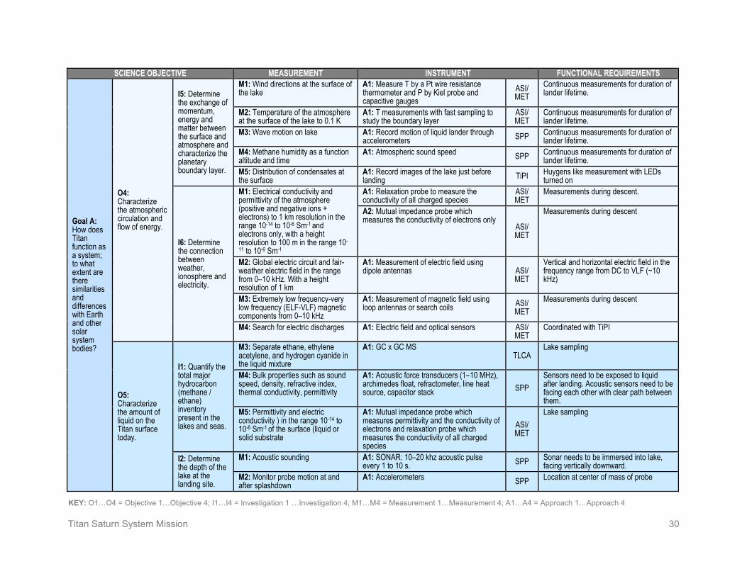
Titan Saturn System Mission 30
KEY: O1…O4 = Objective 1…Objective 4; I1…I4 = Investigation 1 …Investigation 4; M1…M4 = Measurement 1…Measurement 4; A1…A4 = Approach 1…Approach 4
SCIENCE OBJECTIVE MEASUREMENT INSTRUMENT FUNCTIONAL REQUIREMENTS
Goal A: How does Titan function as a system; to what extent are there similarities and differences with Earth and other solar system bodies?
O4: Characterize the atmospheric circulation and flow of energy.
I5: Determine the exchange of momentum, energy and matter between the surface and atmosphere and characterize the planetary boundary layer.
M1: Wind directions at the surface of the lake
A1: Measure T by a Pt wire resistance thermometer and P by Kiel probe and capacitive gauges
ASI/ MET
Continuous measurements for duration of lander lifetime.
M2: Temperature of the atmosphere at the surface of the lake to 0.1 K
A1: T measurements with fast sampling to study the boundary layer
ASI/ MET
Continuous measurements for duration of lander lifetime.
M3: Wave motion on lake A1: Record motion of liquid lander through accelerometers SPP Continuous measurements for duration of
lander lifetime. M4: Methane humidity as a function altitude and time
A1: Atmospheric sound speed SPP Continuous measurements for duration of lander lifetime.
M5: Distribution of condensates at the surface
A1: Record images of the lake just before landing TiPI Huygens like measurement with LEDs
turned on
I6: Determine the connection between weather, ionosphere and electricity.
M1: Electrical conductivity and permittivity of the atmosphere (positive and negative ions + electrons) to 1 km resolution in the range 10-14 to 10-6 Sm-1 and electrons only, with a height resolution to 100 m in the range 10-11 to 10-6 Sm-1
A1: Relaxation probe to measure the conductivity of all charged species
ASI/ MET
Measurements during descent.
A2: Mutual impedance probe which measures the conductivity of electrons only
ASI/ MET
Measurements during descent
M2: Global electric circuit and fair-weather electric field in the range from 0–10 kHz. With a height resolution of 1 km
A1: Measurement of electric field using dipole antennas ASI/
MET
Vertical and horizontal electric field in the frequency range from DC to VLF (~10 kHz)
M3: Extremely low frequency-very low frequency (ELF-VLF) magnetic components from 0–10 kHz
A1: Measurement of magnetic field using loop antennas or search coils ASI/
MET Measurements during descent
M4: Search for electric discharges A1: Electric field and optical sensors ASI/ MET
Coordinated with TiPI
O5: Characterize the amount of liquid on the Titan surface today.
I1: Quantify the total major hydrocarbon (methane / ethane) inventory present in the lakes and seas.
M3: Separate ethane, ethylene acetylene, and hydrogen cyanide in the liquid mixture
A1: GC x GC MS TLCA
Lake sampling
M4: Bulk properties such as sound speed, density, refractive index, thermal conductivity, permittivity
A1: Acoustic force transducers (1–10 MHz), archimedes float, refractometer, line heat source, capacitor stack SPP
Sensors need to be exposed to liquid after landing. Acoustic sensors need to be facing each other with clear path between them.
M5: Permittivity and electric conductivity ) in the range 10-14 to 10-6 Sm-1 of the surface (liquid or solid substrate
A1: Mutual impedance probe which measures permittivity and the conductivity of electrons and relaxation probe which measures the conductivity of all charged species
ASI/ MET
Lake sampling
I2: Determine the depth of the lake at the landing site.
M1: Acoustic sounding A1: SONAR: 10–20 khz acoustic pulse every 1 to 10 s. SPP Sonar needs to be immersed into lake,
facing vertically downward. M2: Monitor probe motion at and after splashdown
A1: Accelerometers SPP Location at center of mass of probe

Titan Saturn System Mission 31
KEY: O1…O4 = Objective 1…Objective 4; I1…I4 = Investigation 1 …Investigation 4; M1…M4 = Measurement 1…Measurement 4; A1…A4 = Approach 1…Approach 4
SCIENCE OBJECTIVE MEASUREMENT INSTRUMENT FUNCTIONAL REQUIREMENTS
Goal A: How does Titan function as a system; to what extent are there similarities and differences with Earth and other solar system bodies?
O6: Characterize the major processes transforming the surface throughout time.
I2: Characterize the origin of major surface features, including the effects of liquid flow, tectonic, volcanic, and impact events.
M3: Map the distribution of different surface features around the landing site
A1: Record images before and after landing
TiPI
Use Saturn shine to map Titan’s surface.
O7: Determine the existence of a subsurface liquid water ocean.
I3: Determine the induced magnetic field signatures in order to confirm subsurface liquid and place constraints on the conductivity and depth of the liquid
M3: Vector magnetic field measurements on the Titan surface to quantify the induced magnetic field and hence constrain the presence of a sub-surface conducting layer (possibly liquid water ocean)
A1: Measure dual sensor (gradiometer) vector magnetic field on Titan’s surface
SPP
Knowledge of probe attitude and location. Continuous magnetic field data (desirable, to combine data with magnetic field measurements from the montgolfière and orbiter). Also desirable (not required) to have some measurements with the lake lander, montgolfière, and orbiter in a line radiating from Saturn. Consideration of magnetic cleanliness requirement, and use of gradiometer configuration.
O8: Determine the state of internal differentiation, whether Titan has a metal core and an intrinsic magnetic field, and constrain the crustal expression of thermal evolution of Titan’s interior.
I3: Quantify exchange between interior and atmosphere.
M1: D/H in methane and ethane to 0.1 per mil in the atmosphere and the lake
A1: Isotope ratio mass spectrometry with GC separation of Hydrogen in atmosphere and pyrolytic reduction to measure D/H in methane and ethane.
TLCA Lake sampling
M2: Measure noble gases A1: Direct inlet into noble gas concentrator / getter and then into an MS
TLCA
In situ analysis of noble gases during the descent and at the surface of the lake

Titan Saturn System Mission 32
KEY: O1…O4 = Objective 1…Objective 4; I1…I4 = Investigation 1 …Investigation 4; M1…M4 = Measurement 1…Measurement 4; A1…A4 = Approach 1…Approach 4
SCIENCE OBJECTIVE MEASUREMENT INSTRUMENT FUNCTIONAL REQUIREMENTS
Goal B: To what level of complexity has prebiotic chemistry evolved in the Titan system?
O1: Determine the chemical pathways leading to formation of complex organics at all altitudes in the Titan atmosphere and their deposition on the surface.
I1: Assay the speciation and abundance of atmospheric trace molecular constituents.
M3: Detailed molecular analysis of the lake and atmosphere above the lake
A1: GC x GC separation followed by high resolution MS.
TLCA
Liquid and atmosphere sampling
I3: Quantify the sources of chemical energy for atmospheric chemistry.
M4: Search for electric discharges during descent
A1: Electric field ASI/ MET
Altitude and attitude measured during the descent by accelerometers and gyros.
A2: Acquire image in the VIS/NIR during the probe’s descent TiPI
Knowledge of position during descent.
14: Determine surface composition.
M2: Map the distribution of different surface features
A1: Record images just after landing TiPI
LEDs turned on
I5: Determine the composition of organics in the lake and the isotopic ratios of major elements.
M1: Isotopic ratio of C, N, and O in the organic molecules to 0.1 per mil
A1: GC x GC separation followed by conversion and isotopic mass spectrometry. Combustion for C and N analysis and pyrolysis for O analysis. TLCA
Lake sampling
O2: Characterize the degree to which the Titan organic inventory is different from known abiotic material in meteorites.
I1: Assay the composition of organic deposits exposed at the surface, including dunes, lakes, and seas.
M2: Inventory organic content of the lakes, including potential solid species in suspension
A1: GC x GC-MS for liquids. Pyrolysis GC x GC – MS for solids TLCA
Lake sampling with solid and liquid separation before analysis
M3: Determine optical and electrical properties of the liquid (transparency, refraction)
A1: Measure refractive index, permittivity, and conductivity SPP
2 kB @ 1 Hz
M4: Determine optical properties of the lake materials to identify time dependent variations
A1: Measure surface albedo variations just before and after landing TiPI
LEDs turned on
I2: Determine the chirality of organic molecules.
M1: Chirality of complex organics A1: GC x GC-MS with derivatization and chiral columns. TLCA
Lake sampling
O3: Characterize what chemical modification of organics occurs at the surface.
I1: Determine the roles of cratering and cryovolcanism in modification and hydrolysis of organics.
M3: Search for complex oxygenated organics dissolved or in suspension
A1: GC x GC-MS for liquids. Pyrolysis GC x GC – MS for solids
TLCA
Lake sampling with solid and liquid separation before analysis

Titan Saturn System Mission 33
KEY: O1…O4 = Objective 1…Objective 4; I1…I4 = Investigation 1 …Investigation 4; M1…M4 = Measurement 1…Measurement 4; A1…A4 = Approach 1…Approach 4
SCIENCE OBJECTIVE MEASUREMENT INSTRUMENT FUNCTIONAL REQUIREMENTS
Goal B: To what level of complexity has prebiotic chemistry evolved in the Titan system?
O5: Characterize bulk composition, sources of nitrogen and methane, and exchange between the surface and the interior.
I1: Determine whether carbon dioxide is primarily internally derived or photochemically produced.
M2: Isotopic composition of atmospheric carbon and oxygen species from the surface to 1500 km.
A2: GC x GC separation of lake samples followed by conversion and isotopic mass spectrometry. Combustion for C analysis and pyrolysis for O analysis. TLCA
Lake sampling
I2: Determine whether methane is primordial or derived from carbon dioxide.
M3: Isotopic composition in lake of carbon in methane to 0.1 per mil and compare with isotopic composition in the atmosphere
A1: Isotope ratio mass spectrometry with GC separation of methane in atmosphere or lake liquid and combustion to measure C isotopes
TLCA Lake and atmosphere sampling
M4: Isotopic ratio of C in other lake organics
A1: GC x GC separation followed by combustion and isotopic mass spectrometry. TLCA Lake sampling
I3: Determine whether molecular nitrogen is derived from ammonia.
M3: Isotopic composition of atmospheric nitrogen and noble gas isotopic ratios (Ar, Kr, Xe) to a precision of 0.1 per mil
A1: Direct inlet into noble gas concentrator / getter and then into a MS TLCA
Measurement made during descent and on the surface.
M4: Analyze dissolved N2 and ammonia in the lakes and determine their isotopic composition
A1: Membrane inlet with cold trapping of ammonia followed by pyrolysis and isotopic mass spectrometry.
TLCA Lake sampling
I5: Determine the isotopic ratios of noble gases
M1: Quantify noble gas isotopic ratios (Ar, Kr Xe)
A2: Direct inlet into noble gas concentrator / getter and then into a MS TLCA
Measurement made during descent and on the surface.

Titan Saturn System Mission 34
2. High-Level Mission Concept Overview See Titan Saturn System Mission Study 2008: Final Report [1], Section 4.
Concept Maturity Level Table 2-1 summarizes the NASA definitions for concept maturity levels (CMLs).The Titan Saturn System Mission (TSSM) concept is between CMLs 5 and 6. Detailed science traceability, defined relationships, and dependencies are all completed for the planning payload. The basic implementation mode has been selected and major partnerships are established. Technologies and risks have been defined. Mitigation plans are in place and some early mitigation activities are being executed. The basic verification and validation (V&V) approach has been defined for the planetary protection and radioisotope power source (RPS) requirements and testbeds/software and integration and test (I&T) approaches are story-boarded. The development schedule has been developed through to the subsystem levels (in some cases below that) and integrated into a master schedule. This schedule was used to develop a quasi-grassroots cost estimate. The spacecraft, planetary protection, project integration and test, and mission design are a grassroots estimate, but other areas are model based. In two areas (mission assurance and education and public outreach) the costs are rules-of-thumb based.
Table 2-1. Concept Maturity Level Definitions Concept
Maturity Level Definition Attributes CML 6 Final Implementation
Concept Requirements trace and schedule to subsystem level, grassroots cost, V&V approach for key areas
CML 5 Initial Implementation Concept
Detailed science traceability, defined relationships and dependencies: partnering, heritage, technology, key risks and mitigations, system make/buy
CML 4 Preferred Design Point Point design to subsystem level mass, power, performance, cost, risk
CML 3 Trade Space Architectures and objectives trade space evaluated for cost, risk, performance
CML 2 Initial Feasibility Physics works, ballpark mass and cost CML 1 Cocktail Napkin Defined objectives and approaches, basic architecture
concept
Technology Maturity
Mission / Orbiter Technology Maturity See Titan Saturn System Mission Study 2008: Final Report [1], Section 4.9.
Montgolfière / Lake Lander Technology Maturity See TSSM In Situ Elements 2008 Assessment Study Report [2], Section 11.

Titan Saturn System Mission 35
Key Trades See Titan Saturn System Mission Study 2008: Final Report [1], Section 4.4.7.
• A single main engine was chosen over a dual engine concept. This trade will be revisited.
• Solar electric propulsion (SEP) was chosen over a chemical system with a large launch vehicle (Delta IV Heavy), or with a longer trip time, and a shorter science phase to keep within the 14-year nominal RPS lifetime. See Table 2-2 for the list of propulsion options.
Table 2-2. TSSM Propulsion Trade
Case Launch Vehicle
Cruise Propulsion
Flight Time to Saturn (years)
In-Situ Element ($RY) ($FY07)
1 A541 Chemical 8 None ($377) ($273) 2 A551 Chemical 10.5 B+L ($205) ($145) 3 A551 SEP 9 B+L — — 4 A521 SEP 7.5 None ($223) ($160) 5 Delta IVH Chemical 9 B+L $244 $148 6 Delta IVH SEP 6 B+L $299 $215 7 Ares V Chemical 3 B+L $159 $136
Table 2-3. TSSM Completed Trade Studies Trade Name Trade Options* Discussion
SEP Include SEP stage vs. chemical only propulsion
Although approximately $100M more expensive, the inclusion of a SEP stage significantly reduces trip time and enhances mission flexibility by providing significant additional margin for mass growth traded against trip time.
SEP architecture
Integral vs. separable SEP stage
A separable SEP stage was chosen for the TSSM design as it allows for a significant mass jettison before Saturn Orbit Insertion (SOI), thus increasing delivered mass capability to Titan. Design of the SEP stage as a self-contained unit also results in a feed-forward flight element that would be available to future missions.
RPS system MMRTG vs. ASRG
ASRGs were chosen based on their reduced mass, increased power output, and reduced cost. If a programmatic decision is made to use MMRTGs, TSSM is carrying extra mass margin (above the required 33%) and power margin to accommodate either RPS system.
Power requirements
Four vs. five vs. Six MMRTGs
Power requirements for science instruments and telecom dictated the use of the equivalent of five MMRTGs. With four MMRTGs, adequate power would not be available to operate instruments (the duty cycles would have to be unacceptably low). Six MMRTGs would make a more comfortable science scenario, but would cause the mission to exceed the study guidelines for available plutonium quantity when combined with the MMRTG on the Montgolfière and RHU demands. Unless NASA directs the use of MMRTGs, this trade is no longer applicable due to a change in study guidelines allowing the use

Titan Saturn System Mission 36
Trade Name Trade Options* Discussion of ASRGs. Subsequent analysis showed that four ASRGs accommodate the power requirements met by five MMRTGs (and even provides more power than the five-MMRTG case). A fifth ASRG is carried as an onboard spare for redundancy.
OpNav camera Include OpNav vs. no OpNav
Optical navigation is needed to determine the orbit of Enceladus to sufficient accuracy to enable low-altitude flybys. Without optical navigation, the altitude of these flybys would likely be limited to 500 km; with optical navigation these flybys could go as low as 25 km (as demonstrated in Cassini's Equinox Mission).
Fine attitude control
RWAs vs. MIT thrusters
RWAs were chosen to perform 3-axis control because, while the micro-impulse thrusters (MITs) require less power (by ~35 W) and will potentially cost less, they may require a large mass hit in hydrazine propellant. The RWAs will provide slightly better pointing control, especially with respect to pointing stability. The MITs have uncertain development and qualification costs at this time.
IMU MIMU vs. SIRU Although the micro-inertial measurement unit (MIMU) is less massive and costly (even though two are required for redundancy), there are concerns with the MIMU’s lifetime. The internally redundant space inertial reference unit (SIRU) was selected for its longer life capability. This trade will be revisited in Phase A.
Thruster layout Coupled vs. uncoupled thrusters
Coupled thrusters were used in the TSSM design to avoid accumulation of unwanted ΔV errors. Additionally, during the release of the in-situ elements, coupled thrusters provide double the control authority, and therefore higher reliability.
Main engine Single vs. dual Two engines for redundancy introduce complexities that have not yet been worked. It was deemed that implementation of this redundancy was not the best use of resources (i.e., cost and mass) at this time. This will be revisited in Phase A.
Thrust control Gimbaled main engine vs. TVC thrusters
A propulsion system table top review concluded that, though a gimbaled main engine is more costly, it is a more robust design. Gimbaling provides a wider range for the center of gravity, which is especially important with the release of two large in-situ elements.
Engine cover Include engine cover vs. no engine cover
There was concern that particulates may damage the engine during Saturn ring crossings, Enceladus plume flybys, and engine-first Titan aerobraking segments of the mission, as well as the long lifetime requirement on the engine.
Propellant tank material
Titanium vs. COPV
Composite overwrapped pressure vessel (COPV) tanks are industry standard and are significantly less massive and less expensive than traditional Titanium tanks.
Propellant tank configuration
Tank mass vs. spacecraft stack height
Although a trade was conducted to determine system-level mass savings for increasing tank width (and therefore mass) and reducing spacecraft stack height (and therefore decreasing overall system mass), ultimately the stack height was not reduced due to in-situ accommodation needs.

Titan Saturn System Mission 37
Trade Name Trade Options* Discussion HGA pointing Monopulse
tracking vs. spacecraft pointing w/ stiff antenna
TSSM has a Mars Reconnaisance Orbiter (MRO)-derived antenna design for maximum stiffness. This includes a body-fixed gimbal platform for the antenna. The open-loop spacecraft pointing design using the stiff antenna was considered the more robust, lower cost option when compared to closed-loop monopulse tracking. Additionally, spacecraft pointing requires a lower demand on DSN resources.
HGA diameter and articulation
3 m vs. 4 m, gimbaled vs. bodyfixed
The 2007 Titan Explorer study made use of a 3 m HGA, but this earlier study assumed 70 m receiving stations. As a result of the 2008 guideline to not assume 70 m stations, it was decided to adopt the larger antenna to recapture some of the data rate that would be lost by relying on the 34 m ground stations. To fit within the confines of the LV fairing, the antenna was positioned on the top deck of the orbiter. This axial location has the added benefits of protecting the spacecraft during ring crossings, serving as a sun shade, and acting as an aerodynamic stabilizer during aerobraking. Deciding to articulate the high gain antenna (HGA) (instead of putting the instruments on a scan platform or body-fixing the antenna and instruments like Cassini) came out of the operations lessons-learned activity.
Radio science and relay communication
UST vs. SDST The universal space transponder (UST) accomplishes orbiter-to-Earth communication, relay communication with the in situ elements, and Ka-uplink (a science requirement) in a single unit, thus taking the place of a small deep space transponder (SDST), an Electra, and a Ka translator. While the SDST is flight proven, it is currently out of production. The UST is under development, and will be monitored carefully throughout Phase A.
Safe mode communication
USO vs. USO not required for communication
An ultra-stable oscillator (USO) is not required for flight-system safe-mode operations (an initial concern), but was included in the design for science purposes because it enables radio occultations in Titan’s atmosphere.
C&DH system interfaces
MSIA Card vs. MREU
MSAP system interface assembly (MSIA) is the card used in the multimission system architecture platform (MSAP) C&DH architecture to interface with other spacecraft systems (in TSSM’s case, the in-situ elements and the OpNav camera), but the MSIA uses significant power. An alternative architecture using a MSAP remote engineering unit (MREU) in place of the MSIA was investigated, but did not realize the power savings originally hoped for and complicated the design.
Memory type Flash vs. SDRAM vs. SRAM
Flash memory is very sensitive to radiation (tolerant to only 7 krad), and would therefore require significant shielding to meet even the modest radiation requirements of this mission. SDRAM was chosen for its rad hard availability and because it provides more memory when compared to a SRAM card with the same sized footprint
Instrument interface type
SpaceWire vs. diversified interfaces
The goal of the TSSM C&DH design was to maximize the use of current MSAP designs. To use a SpaceWire-only system (a high-speed, low-error-rate interface) would have resulted in modifications to the current MSAP SFC card, which has only four SpaceWire ports. The current TSSM design utilizes SpaceWire and RSB for instrument interfaces and 1553 to interface with other spacecraft subsystems.
* = Chosen option indicated in bold.

Titan Saturn System Mission 38
3. Technical Overview Instrument Payload Description See Titan Saturn System Mission Study 2008: Final Report [1], Section 4.2

Titan Saturn System Mission 39
Baseline Orbiter Payload See Titan Saturn System Mission Study 2008: Final Report [1], Section 4.2
Table 3-1. Baseline Instrument Specifications—Orbiter
Units
High Resolution Imager and
Spectrometer (HiRIS)
Titan Penetrating Radar and Altimeter (TiPRA)
Polymer Mass Spectrometer
(PMS)
Submillimeter Spectrometer
(SMS)
Thermal Infrared
Spectrometer (TIRS)
MAPP-Magnetometer
MAPP-Energetic Particle
Spectrometer (EPS)
MAPP-Langmuir
Probe MAPP-Plasma Spectrometer
Radio Science and
Accelerometer (RSA)
Number of channels 3/410 N/A N/A N/A N/A N/A N/A N/A N/A N/A Size/dimensions (for each instrument)
m x m x m 0.3 x 0.5 x 0.6 plus electronics box: 0.07 x 0.15
x 0.20
2 10-m dipole antennae, each stowed 1.5 x 0.3
x 0.2
TBD 0.2 x 0.2 x 0.2 plus 15 cm
parabolic dish
0.3 x 0.4 x 0.5 3.6 m boom TBD TBD TBD TBD
Instrument mass without contingency (CBE*)
kg 28.4 11 29.2 12.3 16.5 2.2 1.5 1.5 5.0 0
Instrument mass contingency % 30 30 30 30 30 30 30 30 30 30 Instrument mass with contingency (CBE+Reserve)
kg 36.9 14.3 38 16 21.5 2.9 2.0 2.0 6.5 0
Instrument average payload power without contingency
w 28 (1 operating) or 32 (both operating)
25 25 (low mass range) or 47 (high
mass range)
45 17 3 2.5 1 9 0
Instrument average payload power contingency
% 30 30 30 30 30 30 30 30 30 30
Instrument average payload power with contingency
w 36.4 32.5 32.5 58.5 22.1 3.9 3.3 1.3 11.7 0
Instrument average science data rate^ without contingency
kbps 77 (imager) or 225 (spec)
20–30 (alt mode) or 280 (sounder) or 20,000 (burst)
2.5–60 (depends on data rate mode)
14 10 4 5 0.1 1–10 (depends on
data rate mode)
TBD
Instrument average science data^ rate contingency
% 0 0 0 0 0 0 0 0 0 0
Instrument average science data^ rate with contingency
kbps 77 (imager) or 225 (spec)
20–30 (alt mode) or 280 (sounder) or 20,000 (burst)
2.5–60 (depends on data rate mode)
14 10 4 5 0.1 1–10 (depends on
data rate mode)
TBD
Instrument fields of view (if appropriate)
degrees 20 N/A Mounted on a rotating platform.
Closed ion source: two 60 half-angle centered on each gas ram direction. Open ion source: two 7.5 half-angle FOVs in the same
directions.
N/A Mid-IR: 3 Far-IR: 4.3
N/A N/A N/A N/A N/A
Pointing requirements (knowledge)
μrad 200 100 2 1 1 5 5 N/A N/A N/A
Pointing requirements (control) millirad 1 100 5 5 3 10 10 N/A N/A N/A Pointing requirements (stability)
μrad /sec 60/1 N/A 1,000/1 1,000/60 1,000/120 1,000/1 1,000/1 N/A N/A N/A
*CBE = Current best estimate ^Instrument data rate defined as science data rate prior to on-board processing

Titan Saturn System Mission 40
Table 3-2. Baseline Payload Mass and Power—Orbiter
Instrument
Mass Average Power CBE (kg) % Cont.
MEV (kg)
CBE (W) % Cont.
MEV (W)
HiRIS 28.4 30 36.9 28 (1 operating) or 32 (2 operating)
30 36.4
TiPRA 11.0 30 14.3 25 30 32.5 PMS 29.2 30 38.0 25 (low mass
range) or 47 (high mass range)
30 32.5
SMS 12.3 30 16.0 45 30 58.5 TIRS 16.5 30 21.5 17 30 22.1 MAPP-MAG 2.2 30 2.9 3 30 3.9 MAPP-EPS 1.5 30 2.0 2.5 30 3.3 MAPP-Langmuir probe
1.5 30 2.0 1 30 1.3
MAPP-plasma spectrometer
5.0 30 6.5 9 30 11.7
RSA 0.0 30 0 0.0 30 0 Total Payload Mass 107.6 – 140.1 155.5* – 202.2*
*The instruments are not operated at the same time, so the spacecraft is not required to supply the total payload power or total payload downlink rate. Maximum instantaneous power supply with margin is 165 W.

Titan Saturn System Mission 41
Baseline Montgolfière Payload See TSSM In Situ Elements 2008 Assessment Study Report [2], Sections 3.4.3.1 and 4.3.1, and 2008 CDF Study Report Tandem Study of a Two-Probe Mission to Titan [3], Section 7.1.1.
Montgolfière instrument mass contingencies are 20%, consistent with ESA practice for items requiring redesign.
Table 3-3. Baseline Instrument Specifications—Montgolfière
Units Balloon Imaging
Spectrometer (BIS)
Visual Imaging System for Titan Balloon (Vista-B)
Atmospheric Structure
Instrument/ Meteorological
Package (ASI/Met)
Titan Electric Environment
Package (TEEP-B) Titan Radar Sounder
(TRS)
Titan Montgolfière Chemical Analyser
(TMCA)
Magnetometer (MAG)
Montgolfière Radio Science Transmitter
(MRST) Number of channels N/A N/A N/A N/A N/A N/A N/A N/A Size/dimensions (for each instrument)
m x m x m 0.26 x 0.24 x 0.15 (optics)
0.2 x 0.3 x 0.1 (electronics)
TBD 0.2 x 0.2 x 0.2 0.1 x 0.1 x 0.02 0.05 x 0.004 x 0.001
(antenna)
0.37 x 0.25 x 0.13 1 m antenna
0.35 x 0.25 x 0.15 Two sensors@ 0.11 x 0.07 x 0.05 and electronics @ 0.1 x 0.12 x 0.03
TBD
Instrument mass without contingency (CBE*)
kg 3.0 2 1.0 1.0 8.0 6.0 0.5 1.0
Instrument mass contingency % 20 20 20 20 20 20 20 20 Instrument mass with contingency (CBE+Reserve)
kg 3.6 2.4 1.2 1.2 9.6 7.2 0.6 1.2
Instrument average payload power without contingency
W 10 5 5 2.0 15 15 1.5 –
Instrument average payload power contingency
% 20 20 20 1 20 20 20 20
Instrument average payload power with contingency
W 12 6 6 20 18 18 1.8 –
Instrument average science data rate^ without contingency
kbps 740 10,240 0.15 1.2 TBD 5 0.8 TBD (very low)
Instrument average science data^ rate contingency
% 0 0 0 0 0 0 0 0
Instrument average science data^ rate with contingency
kbps 740 10,240 0.15 1.2 TBD 5 0.8 TBD (very low)
Instrument fields of view (if appropriate)
degrees N/A N/A N/A N/A N/A N/A N/A N/A
Pointing requirements (knowledge)
μrad N/A N/A N/A N/A N/A N/A N/A N/A
Pointing requirements (control) millirad N/A N/A N/A N/A N/A N/A N/A N/A Pointing requirements (stability)
μrad /sec N/A N/A N/A N/A N/A N/A N/A N/A
*CBE = Current best estimate ^Instrument data rate defined as science data rate prior to on-board processing

Titan Saturn System Mission 42
Table 3-4. Baseline Payload Mass and Power—Montgolfière Mass Average Power CBE
(kg) % Cont.MEV (kg)
CBE (W) % Cont.
MEV (W)
BIS 3.0 20 3.6 10 20 12 Vista-B 2.0 20 2.4 5 20 6 ASI/Met 1.0 20 1.2 5 20 6 TEEP-B 1.0 20 1.2 1 20 1.2 TRS 8.0 20 9.6 15 20 18 TMCA 6.0 20 7.2 8 20 9.6 MAG 0.5 20 0.6 1.5 20 1.8 MRST – 20 – – 20 – Total Payload Mass 21.5 – 25.8 45.5 – 54.6

Titan Saturn System Mission 43
Baseline Lake Lander Payload See TSSM In Situ Elements 2008 Assessment Study Report [2], Sections 3.4.3.2 and 4.3.2, and 2008 CDF Study Report Tandem Study of a Two-Probe Mission to Titan [3], Section 9.1.1.
Table 3-5. Baseline Instrument Specifications—Lake Lander
Units Titan Lander Chemical
Analyzer (TLCA) Titan Probe Imager
(TiPI) ASI/Met-TEEP-L Surface Properties
Package Lander Radio Science Transponder (LRST)
Number of channels N/A N/A N/A N/A N/A Size/dimensions (for each instrument)
m x m x m 0.3 x 0.25 x 0.15 TBD TBD TBD TBD
Instrument mass without contingency (CBE*)
kg 23 1.0 1.5 1.5 2.0
Instrument mass contingency % 20 20 20 20 20 Instrument mass with contingency (CBE+Reserve)
kg 27.6 1.2 1.8 1.8 2.4
Instrument average payload power without contingency
W 75 7.0 5.5 10 20
Instrument average payload power contingency
% 20 20 20 20 20
Instrument average payload power with contingency
W 90 8.4 6.6 13.2 24
Instrument average science data rate^ without contingency
kbps 5.0 10 2.15 16.0 TBD (very low)
Instrument average science data^ rate contingency
% 0 0 0 0 0
Instrument average science data^ rate with contingency
kbps 5.0 10 2.15 16.0 TBD (very low)
Instrument fields of view (if appropriate)
degrees N/A N/A N/A N/A N/A
Pointing requirements (knowledge)
μrad N/A N/A N/A N/A N/A
Pointing requirements (control) millirad N/A N/A N/A N/A N/A Pointing requirements (stability)
μrad /sec N/A N/A N/A N/A N/A
*CBE = Current best estimate ^Instrument data rate defined as science data rate prior to on-board processing
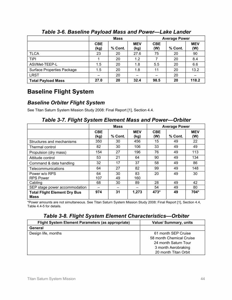
Titan Saturn System Mission 44
Table 3-6. Baseline Payload Mass and Power—Lake Lander Mass Average Power CBE
(kg) % Cont. MEV (kg)
CBE (W) % Cont.
MEV (W)
TLCA 23 20 27.6 75 20 90 TiPI 1 20 1.2 7 20 8.4 ASI/Met-TEEP-L 1.5 20 1.8 5.5 20 6.6 Surface Properties Package 1.5 20 1.8 11 20 13.2 LRST – 20 – – 20 – Total Payload Mass 27.0 20 32.4 98.5 20 118.2
Baseline Flight System
Baseline Orbiter Flight System See Titan Saturn System Mission Study 2008: Final Report [1], Section 4.4.
Table 3-7. Flight System Element Mass and Power—Orbiter Mass Average Power
CBE (kg) % Cont.
MEV (kg)
CBE (W) % Cont.
MEV (W)
Structures and mechanisms 350 30 456 15 49 22 Thermal control 82 30 106 33 49 49 Propulsion (dry mass) 154 27 196 76 49 113 Attitude control 53 21 64 90 49 134 Command & data handling 32 17 37 58 49 86 Telecommunications 64 27 82 99 49 148 Power w/o RPS RPS Power
64 107
30 49
83 160
20 49 30
Cabling 68 30 89 28 49 42 SEP stage power accommodation – – – 54 49 80 Total Flight Element Dry Bus Mass
974 31 1,273 473* 49 704*
*Power amounts are not simultaneous. See Titan Saturn System Mission Study 2008: Final Report [1], Section 4.4, Table 4.4-5 for details.
Table 3-8. Flight System Element Characteristics—Orbiter Flight System Element Parameters (as appropriate) Value/ Summary, units
General Design life, months 61 month SEP Cruise
58 month Chemical Cruise 24 month Saturn Tour 3 month Aerobraking 20 month Titan Orbit
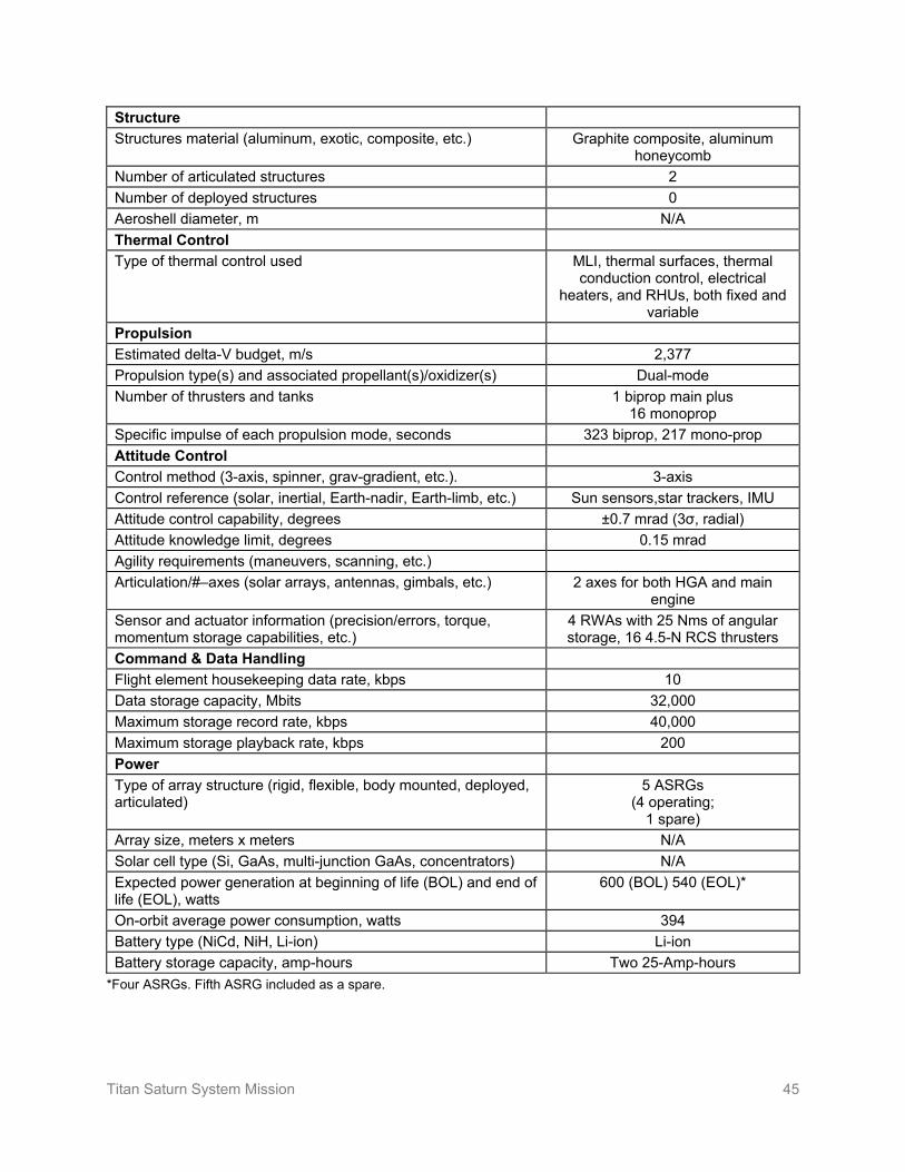
Titan Saturn System Mission 45
Structure Structures material (aluminum, exotic, composite, etc.) Graphite composite, aluminum
honeycomb Number of articulated structures 2 Number of deployed structures 0 Aeroshell diameter, m N/A Thermal Control Type of thermal control used MLI, thermal surfaces, thermal
conduction control, electrical heaters, and RHUs, both fixed and
variable Propulsion Estimated delta-V budget, m/s 2,377 Propulsion type(s) and associated propellant(s)/oxidizer(s) Dual-mode Number of thrusters and tanks 1 biprop main plus
16 monoprop Specific impulse of each propulsion mode, seconds 323 biprop, 217 mono-prop Attitude Control Control method (3-axis, spinner, grav-gradient, etc.). 3-axis Control reference (solar, inertial, Earth-nadir, Earth-limb, etc.) Sun sensors,star trackers, IMU Attitude control capability, degrees ±0.7 mrad (3σ, radial) Attitude knowledge limit, degrees 0.15 mrad Agility requirements (maneuvers, scanning, etc.) Articulation/#–axes (solar arrays, antennas, gimbals, etc.) 2 axes for both HGA and main
engine Sensor and actuator information (precision/errors, torque, momentum storage capabilities, etc.)
4 RWAs with 25 Nms of angular storage, 16 4.5-N RCS thrusters
Command & Data Handling Flight element housekeeping data rate, kbps 10 Data storage capacity, Mbits 32,000 Maximum storage record rate, kbps 40,000 Maximum storage playback rate, kbps 200 Power Type of array structure (rigid, flexible, body mounted, deployed, articulated)
5 ASRGs (4 operating;
1 spare) Array size, meters x meters N/A Solar cell type (Si, GaAs, multi-junction GaAs, concentrators) N/A Expected power generation at beginning of life (BOL) and end of life (EOL), watts
600 (BOL) 540 (EOL)*
On-orbit average power consumption, watts 394 Battery type (NiCd, NiH, Li-ion) Li-ion Battery storage capacity, amp-hours Two 25-Amp-hours
*Four ASRGs. Fifth ASRG included as a spare.

Titan Saturn System Mission 46
Baseline Solar Electric Propulsion (SEP) Flight System See Titan Saturn System Mission Study 2008: Final Report [1], Section 4.4.4.
Table 3-9. Flight System Element Mass and Power—SEP Stage Mass Average Power
CBE (kg) % Cont.
MEV (kg)
CBE (W) % Cont.
MEV (W)
Structures and mechanisms 154 29 199 N/A N/A N/A Thermal control 38 47 56 N/A N/A N/A Propulsion (dry mass) 168 30 218 14,000 N/A 14,000 Attitude control 3 10 3 N/A N/A N/A Command & data handling 8 18 10 N/A N/A N/A Telecommunications N/A N/A N/A N/A N/A N/A Power 96 30 124 15,000 N/A 150,000 Cabling 34 30 44 N/A N/A N/A Total Flight Element Dry Bus Mass
502 31 655 – N/A –
Table 3-10. Flight System Element Characteristics—SEP Stage Flight System Element Parameters (as appropriate) Value/ Summary, units
General Design life, months 61 months Structure Structures material (aluminum, exotic, composite, etc.) Aluminum Number of articulated structures 0 Number of deployed structures Two solar array wings Aeroshell diameter, m N/A Thermal Control Type of thermal control used MLI, heaters Propulsion Estimated delta-V budget, m/s 2,750 Propulsion type(s) and associated propellant(s)/oxidizer(s) SEP Number of thrusters and tanks 3 Specific impulse of each propulsion mode, seconds >4,100* Attitude Control N/A Control method (3-axis, spinner, grav-gradient, etc.). N/A Control reference (solar, inertial, Earth-nadir, Earth-limb, etc.) N/A Attitude control capability, degrees N/A Attitude knowledge limit, degrees N/A Agility requirements (maneuvers, scanning, etc.) N/A Articulation/#–axes (solar arrays, antennas, gimbals, etc.) Three 2-axis gimbals on
thrusters

Titan Saturn System Mission 47
Sensor and actuator information (precision/errors, torque, momentum storage capabilities, etc.)
Command & Data Handling N/A Flight element housekeeping data rate, kbps N/A Data storage capacity, Mbits N/A Maximum storage record rate, kbps N/A Maximum storage playback rate, kbps N/A Power N/A Type of array structure (rigid, flexible, body mounted, deployed, articulated) Two 7.5-kW
Ultraflex wings Array size, meters x meters 6 m diam Solar cell type (Si, GaAs, multi-junction GaAs, concentrators) Triple-junction GaAs Expected power generation at beginning of life (BOL) and end of life (EOL), watts
15 kW
On-orbit average power consumption, watts 15 kW during thrusting Battery type (NiCd, NiH, Li-ion) N/A Battery storage capacity, amp-hours N/A
*NEXT Ion Propulsion System Development Status and Capabilities, Michael J. Patterson and Scott W. Benson, NASA Glenn Research Center, http://esto.nasa.gov/conferences/nstc2007/papers/Patterson_Michael_D10P3_NSTC-07-0014.pdf
Baseline Montgolfière Flight System with Spin Eject See 2008 CDF Study Report Tandem Study of a Two-Probe Mission to Titan [3], Section 7.2.4.
Table 3-11. Flight System Element Mass and Power—Montgolfière Mass Average Power
CBE (kg) % Cont.
MEV (kg)
CBE (W) % Cont.
MEV (W)
Structures 114.9 20 137.9 0 0 0 Balloon 109.9 0 109.9 0 0 0 Thermal control 93.3 5.9 98.8 0 0 0 Mechanisms 25.8 11.5 28.7 0 0 0 Attitude control 5.3 13.9 6.0 6 0 6 Command & data handling 7.9 10.0 8.6 10 0 10 Telecommunications 17.4 17.2 18.7 70 0 70 Power 4.2 16.5 5.0 – 0 – DLS (front and back shields) 18.2 10.0 20.0 0 0 0 Harness 16 20.0 19.2 11 0 11 Total Flight Element Dry Bus Mass
412.9 – 452.8* 97** 0** 97**
*ESA carried 20% margin on top of subsystem contingency for a total of 548.1 kg **The Montgolfière power system was designed for a simultaneous maximum power of 100 W. This is accomplished with load sharing. The maximum simultaneous load is calculated as 92 W.

Titan Saturn System Mission 48
Table 3-12. Flight System Element Characteristics—Montgolfière Flight System Element Parameters (as appropriate) Value/ Summary, units
General Design life, months 6 months after arrival Structure Structures material (aluminum, exotic, composite, etc.) Carbon fiber reinforced
plastic Honey Comb Shells
Number of articulated structures 1 Number of deployed structures 6 Aeroshell diameter, m 2.6 Thermal Control Type of thermal control used RHUs, waste heat Propulsion Estimated delta-V budget, m/s N/A Propulsion type(s) and associated propellant(s)/oxidizer(s) Parachute Number of thrusters and tanks N/A Specific impulse of each propulsion mode, seconds N/A Attitude Control Control method (3-axis, spinner, grav-gradient, etc.). Spinner/gravity-gradient Control reference (solar, inertial, Earth-nadir, Earth-limb, etc.) N/A Attitude control capability, degrees N/A Attitude knowledge limit, degrees 1 Agility requirements (maneuvers, scanning, etc.) N/A Articulation/#–axes (solar arrays, antennas, gimbals, etc.) N/A Sensor and actuator information (precision/errors, torque, momentum storage capabilities, etc.)
3 accelerometers, 2 G-switches, 3 coarse gyros, 3 sun/Saturn
sensor, IMU, pressure sensor
Command & Data Handling Flight element housekeeping data rate, kbps TBD Data storage capacity, Mbits 32,000 Maximum storage record rate, kbps 200,000 Maximum storage playback rate, kbps TBD Power Type of array structure (rigid, flexible, body mounted, deployed, articulated) 1 MMRTG Array size, meters x meters N/A Solar cell type (Si, GaAs, multi-junction GaAs, concentrators) N/A Expected power generation at beginning of life (BOL) and end of life (EOL), watts
100 electrical, 1,690 thermal (EOL)
On-orbit average power consumption, watts 92 electrical, 1,000 thermal
Battery type (NiCd, NiH, Li-ion) N/A Battery storage capacity, amp-hours 0

Titan Saturn System Mission 49
Baseline Lake Lander Flight System with Spin Eject See 2008 CDF Study Report Tandem Study of a Two-Probe Mission to Titan [3], Section 9.2.5.
Table 3-13. Flight System Element Mass and Power—Lake Lander Mass Average Power
CBE (kg) % Cont.
MEV (kg)
CBE (W) % Cont.
MEV (W)
Structures 30.7 20 36.8 0 0 0 Mechanisms 20.5 10 22.6 0 0 0 Thermal control 29.9 1.3 30.3 0 0 0 Propulsion (dry mass) 0 0 0 0 0 0 Attitude control (AOCS) 1.7 12.7 2.0 5 0 5 Command & data handling (DHS) 6.1 10 6.7 12 0 12 Telecommunications 9.3 7 10.0 25 0 25 Power 6.9 13.2 7.8 13 0 13 DLS 13.5 10 14.86 0 0 0 Harness 11 20 13.2 0 0 0 Total Flight Element Dry Bus Mass
129.6 – 144.1 55 0 55
Table 3-14. Flight System Element Characteristics—Lake Lander Flight System Element Parameters (as appropriate) Value/ Summary, units
General Design life, months 9 hours after arrival Structure Structures material (aluminum, exotic, composite, etc.) Carbon fiber reinforced
plastic Honey Comb Shells, impact
attenuation foam Number of articulated structures 0 Number of deployed structures 3 Aeroshell diameter, m 1.8 Thermal Control Type of thermal control used RHUs Propulsion Estimated delta-V budget, m/s N/A Propulsion type(s) and associated propellant(s)/oxidizer(s) Parachutes Number of thrusters and tanks N/A Specific impulse of each propulsion mode, seconds N/A Attitude Control Control method (3-axis, spinner, grav-gradient, etc.). Spinner/gravity-gradient Control reference (solar, inertial, Earth-nadir, Earth-limb, etc.) N/A Attitude control capability, degrees N/A Attitude knowledge limit, degrees N/A Agility requirements (maneuvers, scanning, etc.) N/A Articulation/#–axes (solar arrays, antennas, gimbals, etc.) N/A
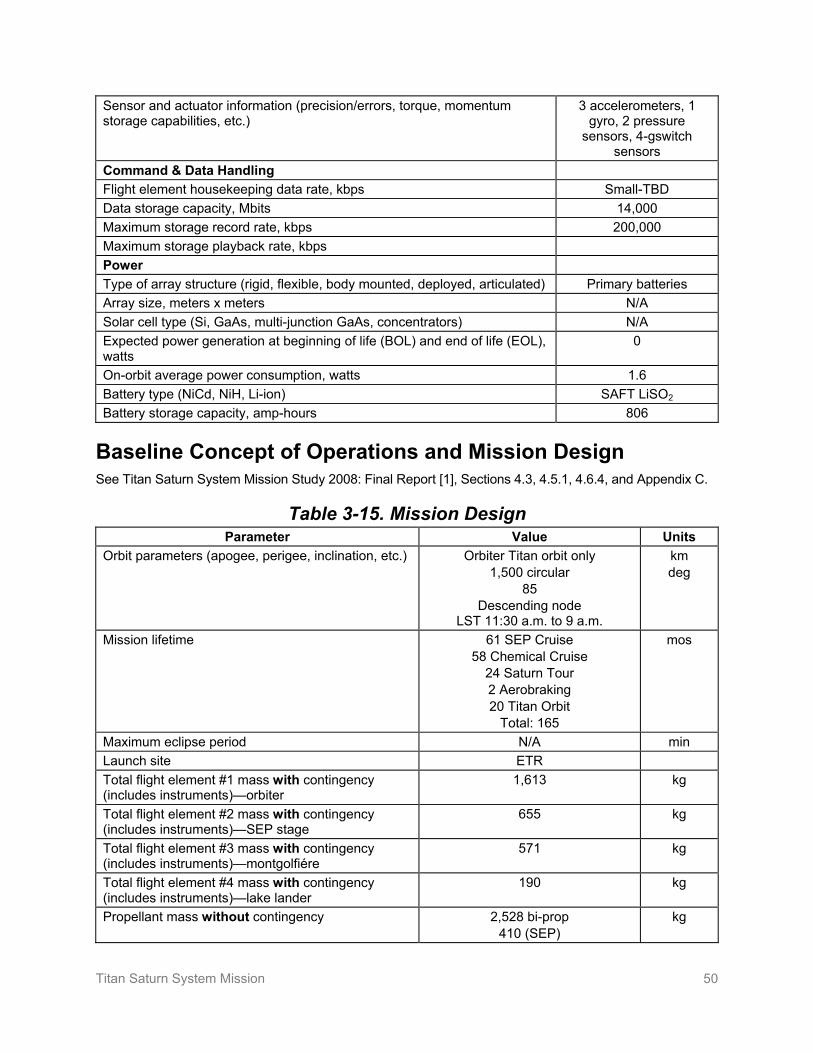
Titan Saturn System Mission 50
Sensor and actuator information (precision/errors, torque, momentum storage capabilities, etc.)
3 accelerometers, 1 gyro, 2 pressure
sensors, 4-gswitch sensors
Command & Data Handling Flight element housekeeping data rate, kbps Small-TBD Data storage capacity, Mbits 14,000 Maximum storage record rate, kbps 200,000 Maximum storage playback rate, kbps Power Type of array structure (rigid, flexible, body mounted, deployed, articulated) Primary batteries Array size, meters x meters N/A Solar cell type (Si, GaAs, multi-junction GaAs, concentrators) N/A Expected power generation at beginning of life (BOL) and end of life (EOL), watts
0
On-orbit average power consumption, watts 1.6 Battery type (NiCd, NiH, Li-ion) SAFT LiSO2 Battery storage capacity, amp-hours 806
Baseline Concept of Operations and Mission Design See Titan Saturn System Mission Study 2008: Final Report [1], Sections 4.3, 4.5.1, 4.6.4, and Appendix C.
Table 3-15. Mission Design Parameter Value Units
Orbit parameters (apogee, perigee, inclination, etc.) Orbiter Titan orbit only 1,500 circular
85 Descending node
LST 11:30 a.m. to 9 a.m.
km deg
Mission lifetime 61 SEP Cruise 58 Chemical Cruise
24 Saturn Tour 2 Aerobraking 20 Titan Orbit
Total: 165
mos
Maximum eclipse period N/A min Launch site ETR Total flight element #1 mass with contingency (includes instruments)—orbiter
1,613 kg
Total flight element #2 mass with contingency (includes instruments)—SEP stage
655 kg
Total flight element #3 mass with contingency (includes instruments)—montgolfiére
571 kg
Total flight element #4 mass with contingency (includes instruments)—lake lander
190 kg
Propellant mass without contingency 2,528 bi-prop 410 (SEP)
kg

Titan Saturn System Mission 51
Propellant contingency 0 bi-prop 10 (SEP)
%
Propellant mass with contingency 2,528 bi-prop 451 SEP fuel
kg
Launch adapter mass with contingency 26 kg Total launch mass 6,203 kg Launch vehicle Atlas V 551 type Launch vehicle lift capability 6,265 kg Launch vehicle mass margin 62 kg Launch vehicle mass margin (%) 35 %
Baseline Orbiter Concept of Operations and Mission Design The orbiter relays data to Earth for both the montgolfière and lake lander as the primary data-link.
Table 3-16. Mission Operations and Ground Data Systems—Orbiter Downlink
Information SEP Cruise Cruise Saturn Tour Aerobraking Titan Orbit Number of contacts per week
1–1.5 0.5 -21 14 21 14
Number of weeks for mission phase, weeks
264 251 104 9 95
Downlink frequency band, GHz
8.425/32.05 8.425/32.05 8.425/32.05 8.425/32.05 8.425/32.05
Sci & telemetry data rate(s), kbps
0.01 0.01 10(x)-200(Ka) 10(x)-200(Ka) 10(x)-200(Ka)
Transmitting antenna type(s) and gain(s), DBi
MGA-X 22 4 m HGA-X; 48.4 4 m HGA-Ka,
60.7
MGA-X 22 4 m HGA-X; 48.4 4 m HGA-Ka,
60.7
MGA-X 22 4 m HGA-X; 48.4 4 m HGA-Ka,
60.7
MGA-X 22 4 m HGA-X; 48.4 4 m HGA-Ka,
60.7
MGA-X 22 4 m HGA-X 48.4; 4 m HGA-Ka,
60.7 Transmitter peak power, watts(DC)
69 69 79 69 99
Downlink receiving antenna gain, DBi
DSS-25 68.4 X;
79 Ka
DSS-25 68.4 X; 79 Ka
DSS-25 68.4 X; 79 Ka
DSS-25 68.4 X; 79 Ka
DSS-25 68.4 X; 79 Ka
Transmitting power amplifier output, watts (RF)
25 25 25-X/35-Ka 25-X/35-Ka 25-X/35-Ka
Total daily data volume (MB/day)
<1 <1 15,000 Max 16.9 14,440
Uplink Information Number of uplinks per day
0.14 0.07 1 1 1
Uplink frequency band, GHz
7.17 7.17 7.17/34.33 7.17/34.33 7.17/34.33
Telecommand data rate, kbps
140 140 140 140 140
Receiving antenna type(s) and gain(s), DBi
MGA, 21.5 MGA, 21.5 4 m HGA-X, 47.0; 4 m
HGA-Ka, 61.3
4m HGA-X, 47.0; 4 m
HGA-Ka, 61.3
4m HGA-X, 47.0; 4 m
HGA-Ka, 61.3
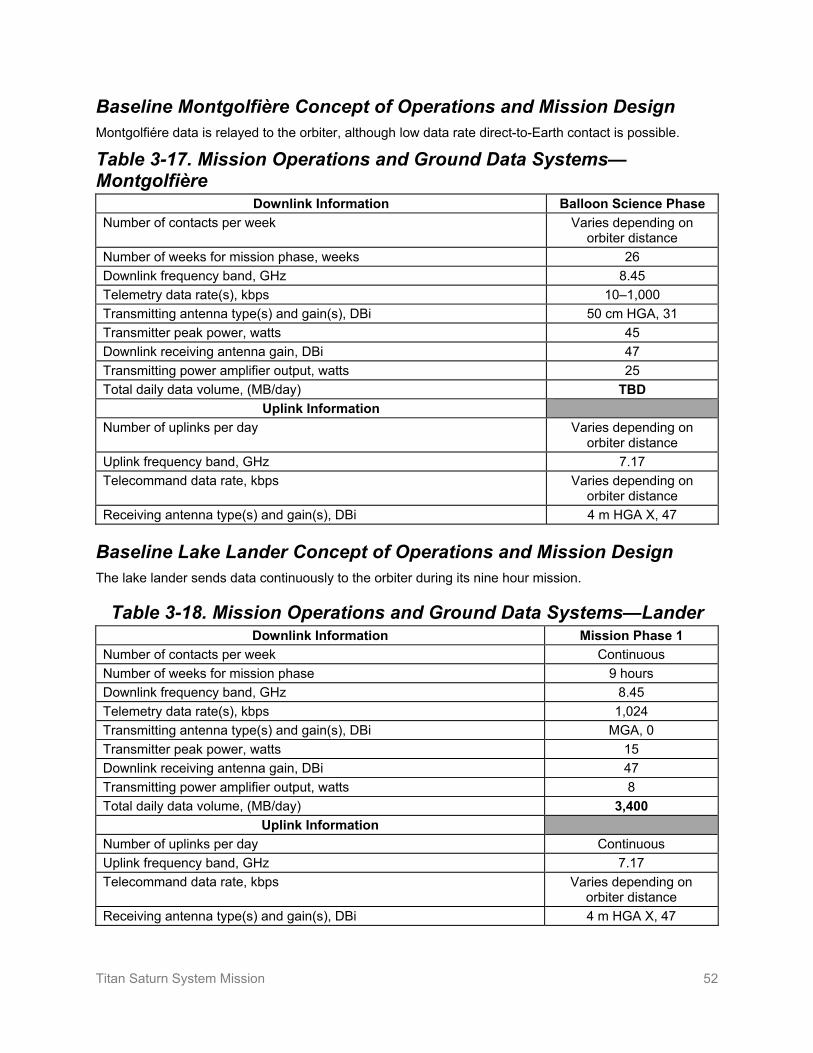
Titan Saturn System Mission 52
Baseline Montgolfière Concept of Operations and Mission Design Montgolfiére data is relayed to the orbiter, although low data rate direct-to-Earth contact is possible.
Table 3-17. Mission Operations and Ground Data Systems—Montgolfière
Downlink Information Balloon Science Phase Number of contacts per week Varies depending on
orbiter distance Number of weeks for mission phase, weeks 26 Downlink frequency band, GHz 8.45 Telemetry data rate(s), kbps 10–1,000 Transmitting antenna type(s) and gain(s), DBi 50 cm HGA, 31 Transmitter peak power, watts 45 Downlink receiving antenna gain, DBi 47 Transmitting power amplifier output, watts 25 Total daily data volume, (MB/day) TBD
Uplink Information Number of uplinks per day Varies depending on
orbiter distance Uplink frequency band, GHz 7.17 Telecommand data rate, kbps Varies depending on
orbiter distance Receiving antenna type(s) and gain(s), DBi 4 m HGA X, 47
Baseline Lake Lander Concept of Operations and Mission Design The lake lander sends data continuously to the orbiter during its nine hour mission.
Table 3-18. Mission Operations and Ground Data Systems—Lander Downlink Information Mission Phase 1
Number of contacts per week Continuous Number of weeks for mission phase 9 hours Downlink frequency band, GHz 8.45 Telemetry data rate(s), kbps 1,024 Transmitting antenna type(s) and gain(s), DBi MGA, 0 Transmitter peak power, watts 15 Downlink receiving antenna gain, DBi 47 Transmitting power amplifier output, watts 8 Total daily data volume, (MB/day) 3,400
Uplink Information Number of uplinks per day Continuous Uplink frequency band, GHz 7.17 Telecommand data rate, kbps Varies depending on
orbiter distance Receiving antenna type(s) and gain(s), DBi 4 m HGA X, 47

Titan Saturn System Mission 53
Planetary Protection See Titan Saturn System Mission Study 2008: Final Report [1], Section 4.7 and Section 4.10.6.
Risk List See Titan Saturn System Mission Study 2008: Final Report [1], Section 4.10.
Implement new process(es) or change baseline plan(s) Aggressively manage; consider alternative process
Monitor
Figure 3-1. Risk Matrix
Very High
High
Moderate
Low
Very Low
Very Low Low Moderate High Very High
Like
lihoo
d
Consequence
PP
OC LV
NX
RP
MLA

Titan Saturn System Mission 54
4. Development Schedule and Schedule Constraints
High-Level Mission Schedule See Titan Saturn System Mission Study 2008: Final Report [1], Section 4.11.6, and TSSM In Situ Elements [2], Section 12.6.
Orbiter / Mission Schedule Table 4-1. Key Phase Duration—Orbiter
Project Phase Duration (Months) Phase A – Conceptual Design 18 Phase B – Preliminary Design 18 Phase C – Detailed Design 24 Phase D – Integration & Test 28 Phase E – Primary Mission Operations 153 Phase F – Extended Mission Operations 6 Start of Phase B to PDR 16 Start of Phase B to CDR 28 Start of Phase B to delivery of instrument #1 45 Start of Phase B to delivery of instrument #2 45 Start of Phase B to delivery of instrument #n 45 Start of Phase B to delivery of flight element #1—orbiter 53 Start of Phase B to delivery of flight element #2—SEP stage 54 Start of Phase B to delivery of flight element #3—montgolfiére 46 Start of Phase B to delivery of flight element #4—lake lander 46 System-level integration & test 26 Project total funded schedule reserve 8.5 Total development time Phase B–D 70

Titan Saturn System Mission 55
Figure 4-1. Schedule—Orbiter

Titan Saturn System Mission 56
Montgolfière / Lake Lander Schedule
Table 4-2. Key Phase Duration—Montgolfière and Lake Lander Project Phase Duration (Months)
Conceptual Design 45 Preliminary Design 21 Phase C – Detailed Design 30 Phase D – Integration & Test 36 Start of Preliminary Design to PDR 21 Start of Preliminary Design to CDR 51 Start of Preliminary Design to Delivery of Instruments 78
Total development time Preliminary Design—Delivery to Project 81

Titan Saturn System Mission 57
Figure 4-2. Schedule—Montgolfière / Lake Lander

Titan Saturn System Mission 58
Technology Development Plan See Titan Saturn System Mission Study 2008: Final Report [1], Section 4.9.
Development Schedule and Constraints See Titan Saturn System Mission Study 2008: Final Report [1], Section 4.3.11, 4.4.2, and 4.4.6.
Figure 4-3. Schedule—Orbiter Testbed / ATLO

Titan Saturn System Mission 59
5. Mission Life-Cycle Cost See Titan Saturn System Mission Study 2008: Final Report [1], Section 4.11.7 and Appendix D.
Costing Methodology and Basis of Estimate The NASA portion of the TSSM cost estimate presented here is the total mission cost for the complete project life cycle from Phase A through Phase F as presented in Table 5-1. Notice that the real year (RY) cost profile is provided for an assumed 2020 launch. The total costs per year and by phase are also presented in 2015 then-year dollars. Note that the total costs per year at the bottom of the table shows costs based on the reserve posture determined in the 2008 study as well as the reserve requirements specified in the NASA ground rules (50% cost reserves for Phases A–D and 25% cost reserves for Phase E).
Cost Estimates
Orbiter Cost Estimates See Titan Saturn System Mission Study 2008: Final Report [1], Appendix D.
The cost to NASA for the orbiter flight system, SEP stage, accommodation of in-situ elements, launch, and operations is shown in Table 5-1.

Titan Saturn System Mission 60
Table 5-1. Total Mission Cost Funding Profile—Orbiter (FY costs in Real Year Dollars, Totals in Real Year and 2015 Dollars)
Phase A Phase B Phase C/D Phase E Phase F Total $RY Total $FY15FY 2013 FY 2014 FY 2015 Total FY 2015 FY 2016 Total FY 2016 FY 2017 FY 2018 FY 2019 FY 2020 FY 2021 Total FY 2021 FY 2022 FY 2023 FY 2024 FY 2025 FY 2026 FY 2027 FY 2028 FY 2029 FY 2030 FY 2031 FY 2032 FY 2033 Total FY 2033 FY 2034 Total All Phases All Phases
01 Project Management 1,026 6,510 1,698 9,235 14,970 15,806 30,777 5,291 21,299 17,601 15,058 14,800 1,084 75,133 6,956 4,700 4,493 4,515 4,655 4,667 4,700 4,900 5,416 5,688 5,959 6,091 4,922 67,660 234 357 591 183,394 158,488 02 Project System Engineering 333 2,744 822 3,899 3,923 5,032 8,955 1,786 7,750 8,470 8,615 8,606 600 35,827 628 707 732 775 785 812 832 862 963 985 1,019 1,056 922 11,078 25 57 83 59,841 53,534 03 Safety & Mission Assurance 701 2,331 738 3,770 7,277 10,837 18,114 5,307 21,134 19,737 10,370 7,756 479 64,784 815 797 760 647 706 632 591 633 956 1,093 1,837 1,901 1,556 12,924 275 642 917 100,510 91,335 04 Science & Technology 250 1,034 253 1,537 4,117 4,181 8,297 3,742 15,532 14,192 8,337 8,621 726 51,151 6,225 7,011 7,253 7,650 7,766 8,023 8,224 8,514 8,979 9,139 46,144 51,123 44,503 220,552 4,145 9,148 13,293 294,831 214,404
04.01 Sci Mgmt 81 334 82 497 1,024 1,042 2,066 391 1,622 1,702 1,737 1,797 152 7,402 1,709 1,926 1,993 2,098 2,134 2,205 2,263 2,343 2,467 2,515 5,277 5,697 4,930 37,558 473 1,014 1,487 49,008 36,609 04.02 Sci Implement 156 646 158 960 2,381 2,416 4,797 3,111 12,916 11,280 4,865 5,033 423 37,627 3,266 3,679 3,808 4,024 4,081 4,217 4,321 4,475 4,729 4,809 33,459 37,267 32,516 144,652 2,997 6,684 9,681 197,718 143,239 04.03 Sci Support 0 1 0 1 4 4 8 2 10 10 8 8 1 39 1,250 1,406 1,452 1,528 1,551 1,600 1,639 1,695 1,783 1,814 7,409 8,158 7,057 38,342 675 1,450 2,126 40,517 27,554
05 Payload System 306 1,365 350 2,021 11,893 13,210 25,103 24,582 101,223 85,189 28,306 28,284 2,356 269,941 - - 297,065 277,592 05.01 PL Sys Mgmt 220 1,010 263 1,492 853 866 1,719 320 1,329 1,400 1,426 1,476 124 6,075 - - 9,287 8,772 05.02 PL System Eng 86 356 86 528 838 1,841 2,679 651 2,703 2,850 2,491 1,735 84 10,512 - - 13,719 12,828 05.04 HiRIS - - - - 2,156 2,215 4,371 4,983 20,489 17,051 5,155 5,300 454 53,432 - - 57,803 53,991 05.05 MAPP Combined Cost - - - - 1,416 1,454 2,869 3,271 13,450 11,193 3,384 3,479 298 35,075 - - 37,944 35,442 05.06 TIRS - - - - 1,747 1,794 3,541 4,037 16,598 13,813 4,176 4,293 368 43,286 - - 46,827 43,739 05.07 PMS - - - - 1,222 1,255 2,478 2,825 11,615 9,666 2,923 3,004 257 30,291 - - 32,769 30,608 05.08 TiPRA - - - - 2,192 2,251 4,443 5,065 20,829 17,334 5,241 5,388 462 54,318 - - 58,762 54,887 05.09 RSA - - - - - - - - - - - - - - - - - - 05.10 SMS - - - - 1,468 1,508 2,976 3,393 13,950 11,609 3,510 3,608 309 36,380 - - 39,356 36,761 05.30 Sci Inst Purge - - - - - 27 27 39 259 274 - - - 572 599 562
06 Spacecraft System 11,140 28,501 9,683 49,324 103,294 130,735 234,029 54,614 210,076 154,866 59,748 40,237 1,742 521,282 - - 804,634 767,029 06.01 SC Mgmt 183 1,275 366 1,824 1,193 1,211 2,404 402 1,670 1,762 1,794 1,859 136 7,622 - - 11,851 11,197 06.02 SC Sys Eng 403 3,149 1,143 4,696 6,321 7,718 14,039 2,561 9,527 8,740 6,538 4,282 223 31,872 - - 50,607 48,050 06a Orbiter 10,275 22,821 7,790 40,885 76,334 104,372 180,706 32,344 156,159 117,446 37,649 30,526 1,196 375,321 - - 596,911 569,581
06a.4 Power SS 246 1,614 686 2,546 5,446 15,967 21,413 1,976 21,785 7,006 1,352 2,133 118 34,370 - - 58,329 55,825 06a.5 C&DH SS 41 2,404 1,487 3,932 10,211 17,199 27,410 4,569 14,885 5,896 477 420 - 26,247 - - 57,589 55,758 06a.6 Telecom SS 7,785 6,115 728 14,628 24,511 11,861 36,372 3,433 18,712 7,035 2,138 2,019 312 33,649 - - 84,649 82,813 06a.7 Mechanical SS 176 1,330 1,183 2,689 11,273 18,213 29,486 6,946 44,260 43,930 6,047 5,685 - 106,869 - - 139,043 131,436 06a.8 Thermal SS 375 1,658 802 2,835 5,328 4,640 9,968 950 4,633 7,775 4,546 2,562 99 20,566 - - 33,369 31,656 06a.9 Propulsion SS 891 5,857 1,285 8,032 9,888 14,937 24,824 4,832 6,069 8,035 1,824 3,140 194 24,096 - - 56,953 55,103 06a.10 GN&C SS 740 3,545 1,226 5,511 6,475 14,355 20,829 6,039 22,523 9,066 3,369 3,184 - 44,181 - - 70,521 67,519 06a.11 Harness - 27 85 112 882 1,120 2,001 372 3,006 4,928 1,913 1,777 - 11,995 - - 14,109 13,121 06a.12 Flight Software - 165 266 431 2,008 4,259 6,266 2,126 14,138 16,307 11,771 7,058 474 51,874 - - 58,572 54,282 06a.13 Materials & Proc 21 106 41 168 239 793 1,032 273 1,134 1,109 483 126 - 3,125 - - 4,324 4,092 06a.14 Flight System Testbeds - - - - 74 1,030 1,104 828 4,249 4,765 2,802 2,421 - 15,064 - - 16,168 14,947 06a.18 Trailblazer - - - - - - - - 766 1,594 927 - - 3,287 - - 3,287 3,031
06b SEP Stage 279 1,255 384 1,919 19,446 17,434 36,880 19,307 42,720 26,918 13,766 3,570 187 106,467 - - 145,265 138,200 06b.3 IPS Subsystem 44 181 44 268 11,260 7,047 18,307 11,346 19,632 5,943 1,419 497 71 38,909 - - 57,484 55,317 06b.4 Power System 17 171 101 289 6,339 7,206 13,544 2,294 9,409 7,036 707 677 36 20,160 - - 33,994 32,559 06b.5 Mechanical - - - - 131 1,199 1,330 863 9,006 6,036 4,926 - - 20,831 - - 22,161 20,678 06b.6 Thermal 111 460 129 699 933 1,068 2,001 390 1,715 3,063 2,687 1,548 18 9,421 - - 12,121 11,310 06b.7 GN&C 107 444 110 662 480 574 1,054 264 1,356 665 330 326 18 2,959 - - 4,674 4,472 06b.8 C&DH - - - - - - - 3,865 - 531 - - - 4,396 - - 4,396 4,254 06b.9 I&T - - - - 303 340 643 283 1,602 3,643 3,698 522 44 9,792 - - 10,435 9,610
07 Mission Operations System 140 1,298 471 1,910 1,865 4,508 6,373 1,801 8,404 9,961 12,612 22,262 2,333 57,374 24,775 25,477 23,730 18,013 21,327 17,283 15,512 17,254 32,664 39,508 42,709 42,037 32,256 352,547 3,703 2,164 5,868 424,071 315,411 08 Launch Services (see below)09 Ground Data System 331 1,530 424 2,286 1,473 4,122 5,595 1,605 8,839 10,342 11,656 13,573 729 46,744 3,189 3,320 3,406 2,982 2,797 2,816 2,378 2,597 3,921 4,532 4,445 4,044 3,380 43,808 258 355 613 99,046 82,360 10 Project System Integration & Test - 145 191 336 1,572 4,676 6,248 2,295 8,217 10,109 20,114 19,873 108 60,717 - - - - - - - - - - - - - - - - - 67,300 61,390 11 Education & Public Outreach 74 245 78 396 764 972 1,736 507 2,013 1,648 871 814 50 5,903 832 813 775 660 720 645 603 646 975 1,115 1,874 1,939 1,587 13,182 157 232 389 21,605 17,128 12 Mission Design 556 3,781 1,032 5,370 3,470 2,991 6,460 906 3,755 3,931 3,881 3,946 251 16,670 - - - - - - - - - - - - - - - - - 28,500 27,112 Subtotal before Reserves 14,858 49,485 15,741 80,083 154,617 197,069 351,686 102,438 408,242 336,046 179,569 168,773 10,458 1,205,525 43,419 42,824 41,149 35,242 38,758 34,877 32,840 35,406 53,873 62,060 103,988 108,190 89,126 721,752 8,798 12,955 21,753 2,380,798 2,065,782 Reserves as determined in 2008 study 1,478 4,924 1,566 7,969 53,849 80,279 134,128 39,192 156,637 146,763 77,822 58,785 3,643 482,843 6,388 6,302 6,056 5,187 5,706 5,135 4,836 5,214 7,935 9,142 15,317 15,938 13,131 106,285 1,296 1,908 3,205 734,429 663,735 Total NASA Phase A-F Cost (No LV) 16,336 54,408 17,307 88,052 208,466 277,348 485,814 141,629 564,879 482,810 257,391 227,558 14,100 1,688,368 49,807 49,126 47,205 40,429 44,464 40,012 37,675 40,620 61,808 71,202 119,305 124,128 102,257 828,037 10,094 14,863 24,957 3,115,227 2,729,517 06a.17 Orbiter RPS - - - - - 21,882 21,882 7,294 29,993 61,665 31,696 - - 130,648 - - 152,530 142,266 06c Lander RPS - - - - - 1,568 1,568 - - - - - - - - - 1,568 1,526 06d Balloon RPS - - - - - 9,821 9,821 2,751 11,313 23,260 11,956 - - 49,280 - - 59,101 55,188 DSN Aperture - - - - - - - - - - - - 3,522 3,522 671 747 768 3,574 812 683 407 419 8,177 13,445 21,143 31,595 25,067 107,508 - - - 111,030 73,407 Launch Vehicle - - - - - - - - 32,412 133,279 102,758 - - 268,448 268,448 246,141 Total NASA Phase A-F Cost (With LV) 16,336 54,408 17,307 88,052 208,466 310,619 519,085 151,674 638,598 701,014 403,800 227,558 17,622 2,140,266 50,478 49,873 47,973 44,003 45,275 40,695 38,083 41,039 69,985 84,647 140,448 155,722 127,324 935,545 10,094 14,863 24,957 3,707,905 3,248,046
Subtotal before Reserves 14,858 49,485 15,741 80,083 154,617 197,069 351,686 102,438 408,242 336,046 179,569 168,773 10,458 1,205,525 43,419 42,824 41,149 35,242 38,758 34,877 32,840 35,406 53,873 62,060 103,988 108,190 89,126 721,752 8,798 12,955 21,753 2,380,798 2,065,782 Reserves of 50% A-D and 25% E as required by NASA SS2012 PS Decadal 7,429 24,742 7,870
40,041 77,309 98,534
175,843 51,219 204,121 168,023 89,784 84,386 5,229 602,762 10,855 10,706 10,287 8,810 9,689 8,719 8,210 8,851 13,468 15,515 25,997 27,047 22,281 180,438 2,199 3,239 5,438 1,004,523 871,609
Total NASA Phase A-F Cost (No LV) 22,286 74,227 23,611 120,124 231,926 295,603 527,529 153,657 612,363 504,070 269,353 253,159 15,686 1,808,287 54,273 53,531 51,437 44,052 48,447 43,596 41,049 44,257 67,341 77,575 129,985 135,237 111,407 902,190 10,997 16,193 27,191 3,385,321 2,937,392 06a.17 Orbiter RPS - - - - - 21,882 21,882 7,294 29,993 61,665 31,696 - - 130,648 - - 152,530 142,266 06c Lander RPS - - - - - 1,568 1,568 - - - - - - - - - 1,568 1,526 06d Balloon RPS - - - - - 9,821 9,821 2,751 11,313 23,260 11,956 - - 49,280 - - 59,101 55,188 DSN Aperture - - - - - - - - - - - - 3,522 3,522 671 747 768 3,574 812 683 407 419 8,177 13,445 21,143 31,595 25,067 107,508 - - - 111,030 73,407 Launch Vehicle - - - - - - - - 32,412 133,279 102,758 - - 268,448 268,448 246,141 Total NASA Phase A-F Cost (With LV) 22,286 74,227 23,611 120,124 231,926 328,874 560,800 163,702 686,081 722,273 415,762 253,159 19,208 2,260,186 54,944 54,278 52,205 47,626 49,259 44,279 41,457 44,676 75,518 91,020 151,128 166,832 136,475 1,009,697 10,997 16,193 27,191 3,977,999 3,455,921
Titan estimate updated with new reserve requirement (50% Phase A-D, 25% Phase E-F)
JLA

Titan Saturn System Mission 61
Montgolfière and Lake Lander Cost Estimates The European Space Agency (ESA) Cosmic Vision 2015–25 call for mission ideas allocated 650 M€ for the cost to ESA for an L-class mission proposal. This was equivalent to approximately $1B US in 2008. Preliminary cost estimates, conducted by ESA and not validated by NASA, confirmed that this limit will not be exceeded provided the following assumptions are correct:
The balloon technology development and balloon material for flight will be provided by CNES without additional ESA contribution.
The NASA-provided orbiter would carry and release the ESA in-situ elements.
The MMRTG and all RHUs would be provided by NASA at no cost to ESA.
The instruments would be contributed by ESA member states
Additional margin was taken into account by ESA to provide for an expected cost increase, if more stringent planetary protection requirements arise should Titan be elevated to category IV.

Titan Saturn System Mission 62
Appendix A. Acronyms AO announcement of opportunity
ASI Italian Space Agency
ASRG advanced stirling radioisotope generators
ATLO assembly, test, and launch operations
BIS balloon imaging spectrometer
CBE current best estimate
COPV composite overwrapped pressure vessel
CML concept maturity level
DSN Deep Space Network
HGA high gain antenna
HiRIS high-resolution imager and spectrometer
I&T integration and test
JSDT Joint Science Definition Team
LV launch vehicle
MAG magnetometer
MAPP magnetometer and plasma package
MEV maximum expected value
MIMU micro-inertial measurement unit
MIT micro-impulse thrusters
MMRTGs multimission radioisotope thermoelectric generator
MREU MSAP remote engineering unit
MRO Mars Reconnaisance Orbiter
MSAP multimission system architecture platform
MSIA MSAP system interface assembly
NRC National Research Council
OPFM Outer Planet Flagship Mission
PMS polymer mass spectrometer
RPS radioisotope power systems
RSA radio science and accelerometer
RWA reaction wheel assembly
RY real year
SDST small deep space transponder
SEP solar electric propulsion
SIRU space inertial reference unit
SMS sub-millimeter sounder
SOI Saturn Orbit Insertion
SPP surface properties package
SSE Solar System Exploration
TEEP Titan electronic environment package
TiPRA Titan penetrating radar and altimeter
TIRS Thermal IR spectrometer
TLCA Titan lander chemical analyzer
TMCA Titan montgolfière chemical analyzer
TRS Titan radar sounder
TSSM Titan Saturn System Mission
USO ultra-stable oscillator
UST universal space transponder
VISTA visual imaging system Titan for balloon
V&V verification and validation
Titan Saturn System Mission 63
Appendix B. References [1] National Aeronautics and Space Administration, and European Space Agency. 30 January 2009.
Titan Saturn System Mission Final Report on the NASA Contribution to a Joint Mission with ESA. Task Order #NM0710851.
[2] National Aeronautics and Space Administration, and European Space Agency. 12 February 2009. TSSM In Situ Elements: ESA Contribution to the Titan Saturn System Mission Assessment Study Report. ESA-SRE(2008)4, Issue 1, Revision 2.
[3] ESTEC Concurrent Design Facility Team. Christian Erd, Study Manager. August 2009. 2008 CDF Study Report Tandem Study of a Two-Probe Mission to Titan. CDF 78A.