Embed Size (px)
DESCRIPTION
planning
Citation preview

AR 413A: Fundamentals of Urban Design and Community Architecture TIP Architecture Arch. Eduardo F. Bober, Jr
The Neighborhood Unit
The concept of the neighborhood unit was developed by and American planner, Clarence Arthur Perry.
This had a huge impact on urban planning worldwide. Perry believed that “cities should be built (or rebuilt)
to consist of an agglomeration of smaller units typically centered on and served by an elementary school
and bounded by major roads with shopping centers at intersections. Children of such units would be able to
walk to their local school without having to cross major roads; the limited size of the units (typically 6-
10,000 inhabitants) would - encourage community spirit. The theory was first publicized in 1939 in Housing
for the Mechanic Age and gained rapid acceptance.
The “neighborhood unit” concept began as a means of combating the existing neighborhoods during this
period seen as “islands locked” amidst a burgeoning sea of vehicular traffic, a dangerous obstacle which
prevented children (and adults) from safely walking to nearby playgrounds and amenities.
The “neighborhood unit” concept evolved to serve a much broader purpose, of providing a discernible
identity for the concept of the "neighborhood", and of offering to designers a framework for disseminating
the city into smaller subareas (suburbs).
The Neighborhood unit defines the neighborhood as a component of a town and defines its size based
upon a five-minute walking radius.
• the center holds the cultural
uses such as a school.
• a five-minute walking
distance is approximately
160 acres.
• Clarence Stein expanded the
definition of neighborhood
center (1942) by connecting
the neighborhoods together
to create towns. In the 1920’s
and 1940’s, the centers and
anchors of neighborhoods
were the schools.
• More recently, the quarter-
mile walking radius has been
expanded to a half mile with
the addition of a transit hub.

• Traditional neighborhood size works well in the town, village, and urban city scales.
PRINCIPLES of Neighborhood Concept
Center the school - to encourage a child's walk to school, which was
only about one-quarter of a mile and no more than one half mile and
could be achieved without crossing a major arterial street.
Size the neighborhood to sufficiently support a school - between 5,000
to 9,000 residents, approximately 160 acres at a density of ten units per
acre.
Implement a wider use of the school facilities – to serve neighborhood
meetings and activities, and constructing a large play area around the
building for use by the entire community.
Place arterial streets along the
perimeter - to define and distinguish
the “place” of the neighborhood and by
design eliminate unwanted through-traffic from the neighborhood. In this way, major arterials define the
neighborhood, rather than divide it through its heart.
Design internal streets using a hierarchy that easily distinguishes local streets from arterial streets, using
curvilinear street design for both safety and aesthetic purposes. Streets, by design, would discourage
unwanted through traffic and enhance the safety of pedestrians.
Restrict local shopping areas to the perimeter or perhaps to the main entrance of the neighborhood, thus
excluding non-local traffic destined for these commercial uses that might intrude on the neighborhood.
Dedicate at least 10 percent of the neighborhood land area to parks and open space
• creating places for play and community interaction (community idealism)
• protecting and promoting the public health and of considering the safety and welfare of citizens
“RADBURN”
The Radburn planning was conceived by Clarance Stein and Henry Wright which was influenced by the
following factors: rapid industrialization after WWI; migration to rural cities; dramatic growth of cities;
housing shortage; and the need to provide housing and protection from motorized traffic. The “Radburn“
planning was inspired by Henry Wright’s “Six Planks for a Housing Platform” as follows:

1. Plan simply, but comprehensively. Don't stop at the individual property line. Adjust paving,
sidewalks, sewers and the like to the particular needs of the property dealt with - not to a
conventional pattern. Arrange buildings and grounds so as to give sunlight, air and a tolerable
outlook to even the smallest and cheapest house.
2. Provide ample sites in the right places for community use: i.e., playgrounds, school gardens,
schools, theatres, churches, public buildings and stores.
3. Put factories and other industrial buildings where they can be used without wasteful
transportation of goods or people.
4. Cars must be parked and stored, deliveries made, waste collected (Vehicular Movement) - plan
for such services with a minimum of danger, noise and confusion.
5. Relationship between buildings. Develop collectively such services as will add to the comfort of
the individual, at lower cost than is possible under individual operation.
6. Arrange for the occupancy of houses on a fair basis of cost and service, including the cost of
what needs to be done in organizing, building and maintaining the community.
THE RADBURN CONCEPT
• SEPARATION of pedestrian and vehicular traffic
• Super block - large block surrounded by main roads
• houses grouped around small CUL DE SACS – each
accessed from main road, Living, Bedroom faced gardens &
parks, service areas to ACCESS ROADS
• remaining land – PARK AREAS
• WALKWAYS – designed such that pedestrians can reach
social places without crossing automobile street.
Financial Planning
• Parks without additional cost from Residents
• Savings from minimizing roads - requires less road area
• 25% less area gave 12-15% of total park area
Clarance Stein’s Conception of the “Neighborhood Unit”
• Walking distance radius is one mile.
• In the figure, an elementary school is the center of the unit and
within a one half mile radius of all residents in the neighborhood,
local shopping centers located near the school.
• Residential streets are suggested as CUL-DESACS to eliminate
through traffic and park space flows into the neighborhood
Traditional Neighborhood Design (Guide to Community Planning in Wisconsin by Brian W. Ohm, http://www.lic.wisc.edu/shapingdane/resources/planning/library/book/chapter05/chap5_2.htm)

Community design issues and concepts also apply on a larger scale than the appearance of one building or
project. Communities around the state reflect a variety of different development patterns that reflect
evolving design concepts at different points of time -- e.g., the grid street patterns of the older sections of
some communities, the curvelinear street pattern of communities built in the 1950's and 1960's, and the cul
de sacs of the 1970's and 1980's and the dispersed development patterns of the 1990's.
Increasingly people are returning to the concepts of traditional neighborhood design, also sometimes
referred to as "new urbanism" or "neotraditional neighborhoods." The concepts focus on a number or
planning and design principles from the early 1900's and earlier. These principles attempt to mirror the type
of community found in the older parts of many
Wisconsin communities. These principles include a mixture of uses that integrate work places, commercial
areas (such as grocery stores), civic spaces (such as parks and town squares) and housing (mixing
housing types and sizes). The design concepts also follows street patterns based on grids or variations of
grids.
Lots sizes in such developments tend to be smaller than in most conventional subdivisions so they
consume less land for the same amount of dwelling units. They average five or more dwelling units per net
acre instead of the one to three houses per net acre that is common in many developing areas.
Walking is encouraged with sidewalks, trees along the streets, narrow roads that slow down cars, and
commercial, and parks that are located a short walk from most houses. Public transportation is also
encouraged.
Four Common Attributes of Traditional Neighborhood Development
1. Neighborhood Size-traditional neighborhoods are generally limited in size to encourage pedestrian
activity. The optimal size of a neighborhood is 1/4 to 1/3 of a mile from center to its edge, a
distance equal to a five to 10 minute walk at an easy pace. Its limited area gathers the population
within walking distance of many of its daily needs.
2. The Street Pattern- Streets in a traditional neighborhood district are designed to accommodate the
needs of all modes of transportation. The neighborhood consists of a interconnected network, like
grids, of small thoroughfares. An interconnected street pattern with smaller blocks provides multiple
routes, diffusing automobile traffic and shortening walking distances. This pattern keeps local traffic
off regional roads and through traffic off local streets. Neighborhood streets of varying types are
designed to provide equitably for pedestrian comfort and automobile movement. Sidewalks are
required.
3. Mix of Land Uses- A traditional neighborhood is structured to provide a balanced mix of
residences, shops, workplaces, civic uses, and recreation within the neighborhood. The integration
of multiple land uses allows residents to meet more of their daily needs through shorter trips.

4. Public Open Spaces- Formal and informal open space is located throughout a traditional
neighborhood. The design of the neighborhood gives priority to open space. These spaces
enhance community activity, identity, and civic pride. The neighborhood plan creates a hierarchy of
useful open spaces: a formal square in the neighborhood center, parks and playgrounds
throughout the neighborhood, and streets that promote walking and encourage informal meetings.
The existing zoning ordinances, subdivision regulations and other land use regulations of many
communities are designed for development patterns of the 1960's or 1970's. The requirements of these
regulations often prohibit the construction of traditional neighborhoods. Often existing zoning ordinances
disallow the densities that are necessary for traditional neighborhoods. The ordinances also generally
preclude the introduction of different uses in neighborhoods.
THE UPDATED NEIGHBORHOOD UNIT (Duany Plater-Zybeck,1994)
• Compact in size
• Mix of uses
• Network of streets
• Public Open Spaces
• Building Typologies
• Parking Strategies
• Transit Opportunities
• Compatibility & Predictability

AR 413A: Fundamentals of Urban Design and Community Architecture TIP Architecture Arch. Eduardo F. Bober, Jr
NEIGHBORHOODS Neighborhoods have long been a focus within the planning field, and neighborhood-based planning is an area that continues to grow. Among other purposes, such an approach is increasingly seen as an essential part of a comprehensive planning process to inform citywide policy and to gain input, clarify priorities, and gamer support for the neighborhood-level details of such plans (Martz 1995; Rohe and Gates 1985). Defining neighborhood for programmatic ends in any given case is problematic, however, because selecting and defining target neighborhoods is a highly political and negotiable process.
DEFINING NEIGHBORHOODS
There is no universal way of defining the neighborhood as a unit. When engaging in neighborhood collaborative planning, the process of neighborhood identification and definition should be considered a heuristic process, guided by programmatic aims, a theoretical understanding of “neighborhood” and descriptive information on the ecological, demographic, social, institutional, economic, cultural and political context in which area exists. There are three dimensions to this heuristic:
• Program goals and strategies
• Neighborhood characteristics
• Contextual influences
Their consideration should be an iterative process, each stage of which is informed by the preceding stage(s), and in the aggregate providing the basis for an informed choice of neighborhood boundaries and an operational definition of neighborhood for given programmatic ends. Framing the consideration of these dimensions is a set of general propositions that inform the process of neighborhood definition in any programmatic context:
• Match the place to the intervention.
• Identify the relevant stakeholders.
• Determine the appropriate change agent(s).
• Determine the necessary capacity to foster and sustain change.
A range of criteria is available that might be used to define particular neighborhoods for given programmatic ends. The process of neighborhood definition proposed here involves attention to these criteria through an iterative series of deliberations, beginning with an articulation and clarification of programmatic goals. These goals reflect assumptions about what needs changing. Program strategies reflect hypotheses about how such change might be brought about. NEIGHBORHOOD SIZE Consideration of neighborhood size should be related to the strategic intervention, operational focus, and desire impact of a given initiative. Three types of possible neighborhood constructions most useful for guiding neighborhood definition are the face-block, the residential neighborhood, and the institutional
neighborhood. These units are nested constructions, each of which provides certain possibilities and constraints for fostering certain kinds of change. Face-Block The neighborhood as a face-block is defined as the two sides of one street between intersecting streets. As a planning unit, the face-block focuses on the interpersonal and provides a high level of opportunity for individual participation. Block-level planning will necessarily focus on a small-scale change, because individual blocks command limited resources and are too small in themselves to wield much influence in the broader community. Residential Neighborhood This construction focuses on neighborhoods as places to live. As a planning unit, the residential neighborhood provides an opportunity to engage residents in planning through different kinds of local governance mechanisms that can incorporate direct participation and potentiality operate as a link to the larger local community. Planning at this level is likely to focus on local issues pertaining to quality of life, including houses, parks, commercial amenities, and transportation access. By itself, the residential neighborhood is less likely to be an appropriate unit of planning targeting broader system change, seeking to foster institutional collaboration, or attempting to support economic development. Institutional Neighborhood The institutional neighborhood is a larger unit that has some official status as a subarea of the city. The institutional neighborhood provides the opportunity to focus on organizational and institutional collaboration and may require the construction of formal mechanisms for citizen participation if individual residents are to be directly represented. NEIGHBORHOOD ELEMENTS AND CHARACTERISTICS The consideration of scale of operation has implications for whether particular kinds of neighborhood elements are to be incorporated within the boundaries of a target neighborhood. It is clear that some such characteristics may be more important for the accomplishment of some programmatic goals than others. Informal Networks of Association While the existence of or potential for informal networks is clearly central to initiatives seeking to develop or strengthen the social organization of a neighborhood, they are also of implied importance in any neighborhood-based endeavor. The informal social organization of a neighborhood, including neighbor relations, activity patterns, and informal service provision, differs across neighborhoods and for different populations (Lee, Campbell, and Miller 1991; Wellman and Wortley 1990) and may provide mechanisms for agency and social support overlooked in more formal approaches to neighborhood. Formal Organizations The availability of neighborhood organizational resources and their use also differs across contexts (Furstenberg 1993). The inclusion of formal organization is especially important when initiative goals focus on system change, service provision, or economic development. Because one assumption behind neighborhood-based work is that it provides the opportunity for greater access by and accountability to residents, neighborhood definition should take into account relationships among organizations and between organizations and residents.
Functional Attributes Functional attribute include those elements necessary for day-to-day living, such as the existence of commercial activities, employment opportunities, recreational facilities, educational opportunities, and health and social services (Warren 1978). The existence of each of these elements represents a portion of the neighborhood’s capacity to sustain certain kinds of activities and promote certain kinds of change (Chaskin et al. 2001). Population Diversity The relative importance of population diversity of homogeneity depends greatly on an initiative’s particular goals. From an organizing perspective, homogeneity is likely to be beneficial, because it provides a clear basis for identity construction and mobilization of residents-particularly in smaller, residential neighborhoods. In larger neighborhoods and where fostering links to the larger community is desired, diversity may be valuable. This is in part a political issue, offering an opportunity to build coalitions across a broader range of constituencies. It may also be an ideological issue, in which promoting diversity is seen as a virtue in its own right. NEIGHBORHOOD CONTEXT Neighborhoods exist in specific contexts, and grounded information about these contexts is essential to any planning process. In addition to socioeconomic and demographic data, other tools such as community assessments, community inventories, and techniques for mapping neighborhood assets can provide valuable information on organizations, available facilities, and resident skills and priorities (Kretzman and McKnight 1993; Bruner et al. 1993). While much information is available through the U.S. Census and various administrative sources, a great deal of (often qualitative) data may not be readily available. The relational dynamics among these elements within the neighborhood, for example, and with actors beyond the neighborhood may be important for both the definition of the neighborhood in given programmatic cases and for ongoing planning and implementation. Identifying and determining the most useful boundaries of particular target neighborhoods for programmatic purposes is much enhanced by the ability to map such relationships, and the ability to inform an interpretation of the impact of such relationships through a qualitative understanding of their dynamics. BOUNDARY IDENTIFICATION The criteria for boundary selection should reflect the goals and strategies of a given initiative, consider contextual influences, and examine the sets of choices made regarding appropriate neighborhood scale and the relative importance of various neighborhood elements. The typology of possible neighborhood definitions implies certain guidelines regarding boundary identification: the face-block is bounded by the first streets that separate a resident’s home from the aggregation of homes beyond; the residential neighborhood implies some consensus regarding boundaries on the part of residents; and the boundaries of an institutional neighborhood have been in some way made official, codified and recognized by certain organizations and institutions. “Recognized” Boundaries Consistent with the assumption behind the residential neighborhood, “recognized” boundaries imply the existence of some degree of neighborhood identity and provide the basis for fostering a sense of

community. To the extent that the larger local community also recognizes such neighborhood definition, it may help residents and neighborhood groups to advocate their causes with government and other extra-local entities. Administrative and Political Boundaries Administrative or political boundaries tend to define larger areas. Given a more system-oriented or institutionally based approach, the use of such boundaries to define the target neighborhood may be appropriate. However, rarely do administrative and political boundaries coincide with each other, nor do they reflect the social organization aspects of neighborhoods. The choice of a set of administrative boundaries to define neighborhood may be most useful for sector-bound, institutionally based interventions. Created Boundaries Institutional neighborhoods may be officially defined without functioning as an administrative unit. However, because such neighborhoods have no single administrative structure and are rarely recognized as political units, issues of management and long term representation should be examined. The creation of a neighborhood governance structure that can coordinate constituent neighborhood priorities and activities, as well as represent the neighborhood to the larger community, may help to increase the long-term impact and sustainability of neighborhood based work. CONCLUSION While these guidelines can help direct a process of neighborhood definition, they do not constitute a definitive blueprint for action. The act of defining a neighborhood is a product of both the social and spatial context of the area and subject to several factors including the purpose for defining the neighborhood, the function that the neighborhood is expected to perform, and the presence of existing neighborhood organizations. Further, the delineation of boundaries is a negotiated process; it is a product of individual cognition, collective perceptions, and organized attempts to codify boundaries to serve political or instrumental aims. The attempt to define neighborhood boundaries for any given program or initiative is thus often a highly political process. These and other factors have to be considered during the planning process, which will be conditioned by the existence of enduring tensions between strategic choices that must be made and by the need for meaningful participation, sound information, and the mechanisms and tools to use them both. REFERENCE: Steiner, Frederick and Butler, Kent (2007). Planning and Urban Design Standards, Student Edition, APA, J.Wiley and Sons, Inc., NJ., USA

(Urban) REVITALIZATION
EDUARDO F. BOBER, JR Industry Lecturer

Revitalization
Revitalization planning simply means
organizing efforts to bring vitality back to
a declining area. The term "revitalization
planning" encompasses a host of other
terms used for this effort, such as
redevelopment and intensification, and
may include such planning tools as a
specific plan or redevelopment plan.

Revitalization Urban revitalization means to put new life into
cities and to upgrade areas for higher social and economic uses. Involves investment to remodel or rebuild a portion of urban environment to accommodate more profitable activities & expand opportunities for consumption, particularly retail and housing for middle and upper income households.
According to Cowan (2005) revitalization is used to refer to ways of bringing a place to life (e.g. finding new uses for old buildings, promoting cultural activities) that, unlike regeneration do not necessarily involve significant buildings.

Recognize that an area has lost its vitality
Analyze reasons why this has occurred
Create a strategy to bring life back to the
area
Develop a common future "vision" for this
area
Put in place plans that identify and direct
tasks toward that end
Create the tools that implement those tasks
Monitor & correct implementation progress
The general steps of a revitalization
plan are to:
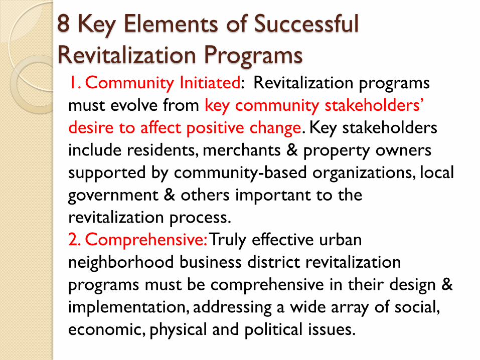
1. Community Initiated: Revitalization programs
must evolve from key community stakeholders’
desire to affect positive change. Key stakeholders
include residents, merchants & property owners
supported by community-based organizations, local
government & others important to the
revitalization process.
2. Comprehensive: Truly effective urban
neighborhood business district revitalization
programs must be comprehensive in their design &
implementation, addressing a wide array of social,
economic, physical and political issues.
8 Key Elements of Successful
Revitalization Programs

3. Collaborative: Creating an effective collaborative
process is extremely important to the revitalization
effort for two primary reasons: It allows
stakeholder voices to be heard and brings together
the collective resources of the community.
4. Diverse: Based on current demographic trends,
urban neighborhoods are becoming increasingly
culturally, racially, & economically diverse places to
live, work and recreate. The best revitalization
programs embrace this diversity and incorporate it
as a community asset.
8 Key Elements of Successful
Revitalization Programs
5.Vision Directed: The agreed upon vision should
focus on the future and lead to specific, realistic and
achievable activities directed toward changes—both
large and small—within a certain timeframe.
6. Capital Intensive: Involve significant new capital
investment in commercial and residential real estate
development, interior and storefront renovations,
infrastructure and streetscape improvements. The
revitalization plan must ensure the availability of
adequate capital to support these types of activities.
8 Key Elements of Successful
Revitalization Programs

7. Market Oriented: Understanding their markets
and will lead to the development of realistic
strategies for economic growth.
8. Sustainable: Revitalization of urban neighborhood
business districts requires a long-term approach.
Stakeholders must continuously identify resources,
both financial and human, to sustain the
revitalization effort as well as build new institutional
and systemic change mechanisms to manage the
business district as a community asset over the
course of many years.
8 Key Elements of Successful
Revitalization Programs

Downtown Revitalization
Downtown revitalization is the process of improving the economic, physical and social well being of a community's traditional town centre by:
Strengthening local business and encouraging investment by building and property owners
Creating enjoyable public streets and spaces animated by a variety of creative and civic activities
Providing work and living opportunities that respond to people's needs across a spectrum of ages and interests.

Downtown Revitalization
Concept
Pedestrian
Friendly
Sidewalk
Mixed Used
bldg
Open Space
Alfresco
Dinning
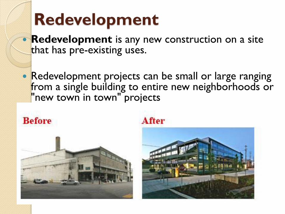
Redevelopment Redevelopment is any new construction on a site
that has pre-existing uses.
Redevelopment projects can be small or large ranging from a single building to entire new neighborhoods or "new town in town" projects

Variations on redevelopment
include:
Urban infill on vacant parcels that have no
existing activity but were previously developed, especially on Brownfield land, such as the redevelopment of an industrial site into a mixed-use development.
Constructing with a denser land usage, such as the redevelopment of a block of townhouses into a large apartment building.
Adaptive reuse, where older structures which have outlive their uses are converted into new ones, such as an industrial mill into housing lofts.

Brownfield Land are abandoned or
underused industrial and commercial
facilities available for re-use. Expansion or
redevelopment of such a facility may be
complicated by real or perceived
environmental contaminations.
Greyfield land is a term used in the United
States and Canada to describe economically
obsolescent, outdated, failing, moribund
and/or underused real estate assets or land.

Examples of Brownfield
redevelopment

Examples of Brownfield
redevelopment


The Bankside Power Station in London was converted for use as the Tate Gallery. Shown is the former turbine hall, converted to house exhibits.

Urban renewal
Urban renewal is a program of land redevelopment in areas of moderate to high density urban land use.
Urban renewal may involve relocation of businesses, the demolition of structures, the relocation of people (slum or informal settlements clearance), and the use of eminent domain (government purchase of property for public use) as a legal instrument to take private property for city-initiated development projects.

Urban Renewal
scheme to redress a complex of urban
problems, including unsanitary, deficient,
or obsolete housing; inadequate
transportation, sanitation, and other
services and facilities; haphazard land use;
traffic congestion; and the sociological
correlates of urban decay, such as crime.

Processes in Urban Renewal
Enlargement of pedestrian zones, mostly in the centers of cities
Renewal of historic tradition –housing, industrial units, open spaces, green areas, parks, specific milieus
New construction – interpolations or renovations of the whole part of a city
The creation of new construction zones
Construction of new housing and business buildings

Processes in Urban Renewal
“Beautification”, refurbishing usually of central parts of cities – new lights, new pavements, new urban “furniture”
Rehabilitation of old and organization of new green & recreation areas
Restrictions of the extension of private traffic, especially into central zones
Better organization, expansion, and multiplication of types & means of public transportation

Examples of Urban Renewal
Cheonggyecheon Seoul, South Korea
Cheonggyecheon is an 8.4 km long, modern
public recreation space in downtown Seoul,
South Korea. The massive urban renewal
project is on the site of a stream that flowed
before the rapid post-war economic
development required it to be covered by
transportation infrastructure. It is a $900M
project that attracted many criticisms.

Cheonggyecheon BEFORE
During first half of 20th century

Cheonggyecheon BEFORE
During Restoration in 2003

Cheonggyecheon TODAY

Cheonggyecheon TODAY

Cheonggyecheon TODAY
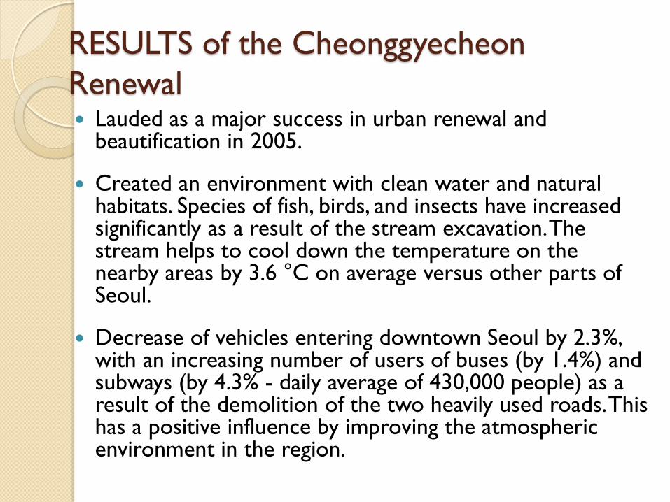
RESULTS of the Cheonggyecheon
Renewal Lauded as a major success in urban renewal and
beautification in 2005.
Created an environment with clean water and natural habitats. Species of fish, birds, and insects have increased significantly as a result of the stream excavation. The stream helps to cool down the temperature on the nearby areas by 3.6 °C on average versus other parts of Seoul.
Decrease of vehicles entering downtown Seoul by 2.3%, with an increasing number of users of buses (by 1.4%) and subways (by 4.3% - daily average of 430,000 people) as a result of the demolition of the two heavily used roads. This has a positive influence by improving the atmospheric environment in the region.

RESULTS of the Cheonggyecheon
Renewal
Promoted the urban economy through
amplifying urban infrastructure for a
competitive city within the existing business
and industrial area centered on the stream.
The Urban renewal project was the catalyst
of revitalization in downtown Seoul.
Cheonggyecheon became a centre for
cultural and economic activities.

Rockwell Center, Makati, Phils.
Transformation of an unused thermal
power plant in 1995 into a thriving, self-
contained community.
Now known as the Rockwell Center, this
flagship development was the first of
several exceptional communities which
now serve as the benchmark for living,
leisure, and business.

Rockwell Center BEFORE Meralco Thermal Power Plant in 1995

Rockwell Center TODAY

RESULTS of the Renewal
Rockwell Center sets a standard in urban regeneration projects within a city where the highest levels and most progressive visions of urban life must be taken into consideration.
Strategically links residential, commercial, institutional, recreational, leisure, office, and religious spaces to minimize the need for transportation, providing a safe and convenient pedestrian & vehicular circulation system

Rockwell Center TODAY

Thank you.

Transit Transit --Oriented Oriented Development (TOD)Development (TOD)
Eduardo F. Bober, Jr. Industry Lecturer
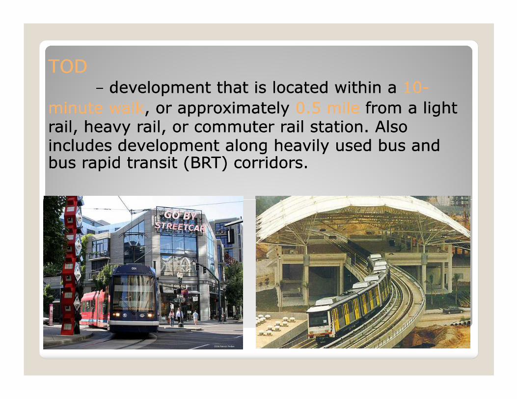
TOD TOD -- ddevelopment that is located within a evelopment that is located within a 1010--
minute walkminute walk, or approximately , or approximately 0.5 mile0.5 mile from a light from a light rail, heavy rail, or commuter rail station. Also rail, heavy rail, or commuter rail station. Also includes development along heavily used bus and includes development along heavily used bus and bus rapid transit (BRT) corridors. bus rapid transit (BRT) corridors.

TODTOD-- aa typetype ofof communitycommunity developmentdevelopment thatthat
includesincludes aa mixturemixture ofof housing,housing, office,office, retailretail andand /or/orotherother amenitiesamenities integratedintegrated intointo aa walkablewalkableneighborhoodneighborhood andand locatedlocated withinwithin aa halfhalf--milemile ofofqualityquality publicpublic transportationtransportation..

TOD TOD ConceptConcept
Transportation Transportation (rail or bus (rail or bus systems)systems)
HighHigh--DensityDensity
LowLow--DensityDensity0.5 mile radius

TOD TypesTOD Types
RURAL TOD

TOD TypesTOD Types
SUBURBAN TOD

TOD TypesTOD TypesURBAN CENTER TOD

FACTORS DRIVING THE FACTORS DRIVING THE TREND TOWARD TODTREND TOWARD TOD
--Rapidly growing, mindRapidly growing, mind--numbing numbing traffic congestion nationtraffic congestion nation--widewide
--Growing distaste for suburbia Growing distaste for suburbia and fryand fry--pit strip developmentpit strip development
--Growing desire for urban quality Growing desire for urban quality urban urban urban urban
--Growing desire for more Growing desire for more walkablewalkable lifestyles away from lifestyles away from traffictraffic
--Changes in family structures: Changes in family structures: more singles, emptymore singles, empty--nesters, etcnesters, etc
--Growing national support for Growing national support for Smart GrowthSmart Growth

� Land areas within the half-mile radius have already been developed
� Transit is not yet an available option
� Potential development sites are not suitable for TOD
Factors that limit Factors that limit opportunities for TODopportunities for TOD
suitable for TOD ◦ TOD projects contain at least 100,000 sq.ft. for 60-80 housing units
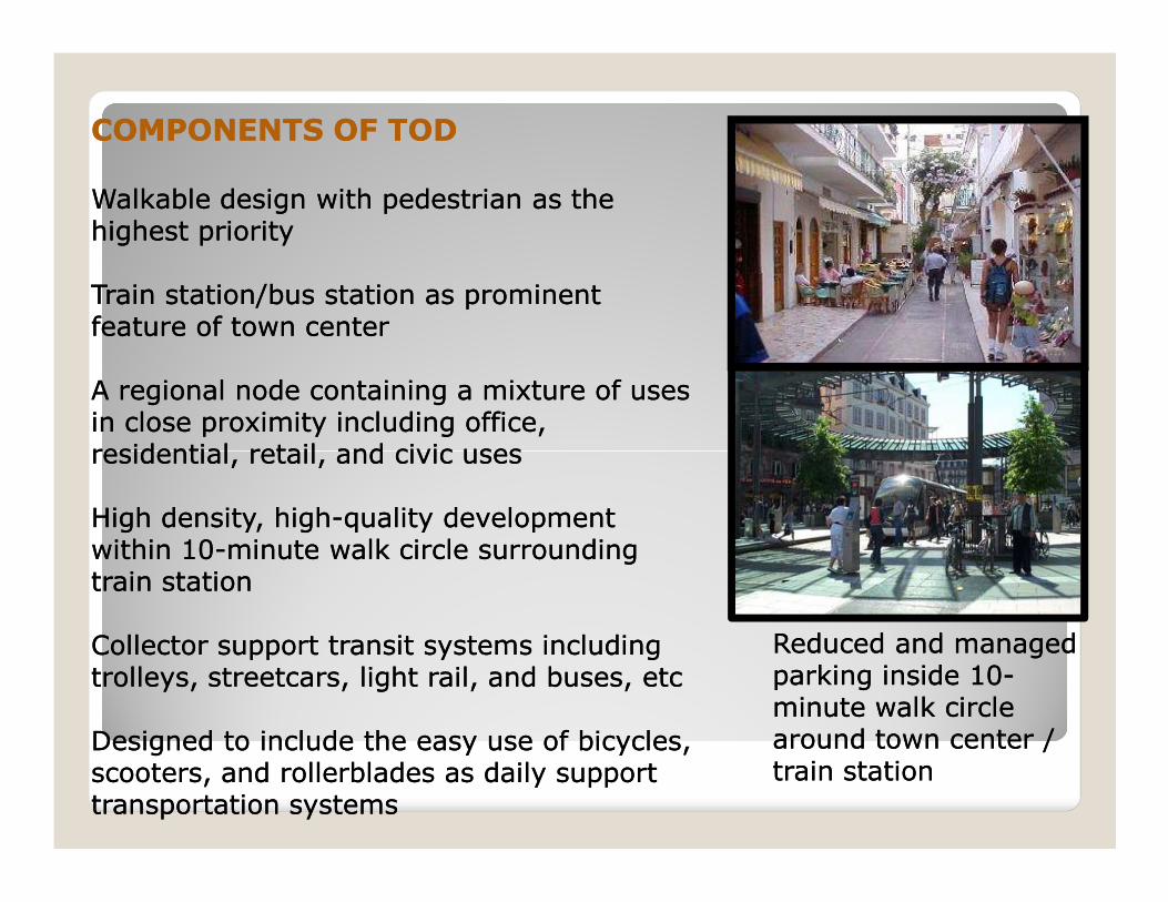
COMPONENTS OF TODCOMPONENTS OF TOD
WalkableWalkable design with pedestrian as the design with pedestrian as the highest priorityhighest priority
Train station/bus station as prominent Train station/bus station as prominent feature of town centerfeature of town center
A regional node containing a mixture of uses A regional node containing a mixture of uses in close proximity including office, in close proximity including office, residential, retail, and civic usesresidential, retail, and civic usesresidential, retail, and civic usesresidential, retail, and civic uses
High density, highHigh density, high--quality development quality development within 10within 10--minute walk circle surrounding minute walk circle surrounding train stationtrain station
Collector support transit systems including Collector support transit systems including trolleys, streetcars, light rail, and buses, etctrolleys, streetcars, light rail, and buses, etc
Designed to include the easy use of bicycles, Designed to include the easy use of bicycles, scooters, and rollerblades as daily support scooters, and rollerblades as daily support transportation systems transportation systems
Reduced and managed Reduced and managed parking inside 10parking inside 10--minute walk circle minute walk circle around town center / around town center / train stationtrain station

FOUR PRINCIPLES FOR TOD SITE FOUR PRINCIPLES FOR TOD SITE PROGRAM PROGRAM
BUILD DENSELYBUILD DENSELYReduced auto dependencyReduced auto dependencyEfficient use of TOD sitesEfficient use of TOD sitesSupport pedestrianSupport pedestrian--friendly shopfriendly shopCreate lively, people filled environmentCreate lively, people filled environment
MIX USESMIX USESCreate dynamic & enliven sidewalks Create dynamic & enliven sidewalks Create dynamic & enliven sidewalks Create dynamic & enliven sidewalks
and public spacesand public spaces
MIX HOUSING TYPES AND PRICESMIX HOUSING TYPES AND PRICESIncrease diversity in housingIncrease diversity in housing
REDUCE PARKING REQUIREMENTREDUCE PARKING REQUIREMENTFeasible to construct structured Feasible to construct structured
parking or belowparking or below--grade parkinggrade parking

DESIGN FEATURES (Site Planning DESIGN FEATURES (Site Planning Process) Process)
PEDESTRIAN ACCESSPEDESTRIAN ACCESSLink pedestrian accessLink pedestrian access
PUBLIC SPACESPUBLIC SPACESCreate NEW public spacesCreate NEW public spaces
SENSE OF PLACESENSE OF PLACEIdentity for the developmentIdentity for the development
PEDESTRIAN EXPERIENCEPEDESTRIAN EXPERIENCEPEDESTRIAN EXPERIENCEPEDESTRIAN EXPERIENCEFoster an increased pedestrian Foster an increased pedestrian
experienceexperienceCHARACTER AND QUALITYCHARACTER AND QUALITY
Emphasize placeEmphasize place--makingmakingARCHITECTUREARCHITECTURE
Encourage design that convey a Encourage design that convey a sense of quality, permanence, & sense of quality, permanence, & communitycommunity--enriching characterenriching character
SUSTAINABILITYSUSTAINABILITYGreen site and building designsGreen site and building designs

BENEFITS OF TODBENEFITS OF TOD
QUALITY OF LIFEQUALITY OF LIFEEnhance community livingEnhance community livingPUBLIC HEALTHPUBLIC HEALTHImprove air qualityImprove air qualityECONOMIC DEVELOPMENTECONOMIC DEVELOPMENTAccess to jobs, broaden tax baseAccess to jobs, broaden tax basePEDESTRIAN EXPERIENCEPEDESTRIAN EXPERIENCEFoster an increased pedestrian Foster an increased pedestrian
experienceexperienceexperienceexperienceCOMMUNITY CHARACTERCOMMUNITY CHARACTERCreates public spaces, gives vitalityCreates public spaces, gives vitalityENVIRONMENTAL QUALITYENVIRONMENTAL QUALITYDesign Alternative to sprawlDesign Alternative to sprawlEncourages “green” urbanismEncourages “green” urbanismTRANSIT USETRANSIT USEIncreased ridershipIncreased ridership

PHILIPPINESPHILIPPINESA R A N E T A C E N T E RA R A N E T A C E N T E R

VANCOUVERVANCOUVERA R L I N G T O NA R L I N G T O N

AR 413A: Fundamentals of Urban Design and Community Architecture TIP Architecture Arch. Eduardo F. Bober, Jr
PARTICIPATION
Role of Participation
Community participation is the involvement of people in the creation and management of their built and
natural environments. Its strength is that it cuts across traditional professional boundaries and cultures. The
activity of community participation is based on the principle that the built and natural environments work
better if citizens are active and involved in its creation and management instead of being treated as passive
consumers (Sanoff 2000).
The main purposes of participation are:
• to involve citizens in planning and design decision-making processes and, as a result, make it
more likely they will work within established systems when seeking solutions to problems;
• to provide citizens with a voice in planning and decisions, service delivery, and overall quality of the
environment, and
• to promote a sense of community by bringing together people who share common goals.
Participation should be active and directed; those who become involved should experience a sense of
achievement. Traditional planning procedures should be reexamined to ensure that participation achieves
more than simply affirmation of the designer’s or planner’s intentions.
Characteristics of Participation
Although any given participation process does not automatically ensure success, it can be claimed that the
process will minimize failure. Four essential characteristics of participation can be identified:
• Participation is inherently good.
• It is a source of wisdom and information about local conditions, needs, and attitudes, and thus
improves the effectiveness of decision making.
• It is an inclusive and pluralistic approach by which fundamental human needs are fulfilled and
user values reflected.
• It is a means of defending the interest of groups of people and of individuals, and a tool for
satisfying their needs, which are often ignored and dominated by large organizations,
institutions, and their bureaucracies.
Experiences in the participation process show that the main source of user satisfaction is not the degree to
which a person’s needs have been met, but the feeling of having influenced the decisions.

Categories of Participation
Participation can be classified into four categories, or “Experiences” with the goal of achieving agreement
about what the future should bring (Burns 1979)
The ladder of citizen participation presents a typology of eight levels of participation. Each rung of the
ladder corresponds to the degree to which stakeholders had power in determining the outcome. The
gradations represented go from nonparticipation to token participation to various degrees of citizen power.
While the ladder was conceived in the context of federal programs of the late 1960’s, planners and urban
designers today still should strive to ensure that they are working near the top of the ladder in their public
participation activities.
LADDER OF CITIZEN PARTICIPATION
• Awareness; this experience involves discovering or rediscovering the realities of a given situation
so that everyone who takes part in the process speaks the same language, which is based on
experiences in the field where change is proposed.
• Perception; this entails going from awareness of the situation to understanding it and its physical,
social, cultural, and economic ramifications. It means sharing with each other so that the
understanding, goals, and expectations of all participants.
• Decision making; this experience concentrates on working from awareness and perception to a
plan for the situation under consideration. Here participants propose plans, based on their
priorities, for professionals to use as resources to synthesize alternative and final plans.
• Implementations; many community-based planning processes stop with awareness, perception,
and decision making. This can have significant detrimental effects on a project because it ends
people’s responsibilities when the “how-to, where-to, when-to, and who-will-do-it” must be added to
what people want and how it will look. People must stay involved throughout the processes and
take responsibility with their professionals to see that there are results (Hurwitz 1975)
DETERMINATION OF GOALS AND OBJECTIVES
The planning that accompanies the design of any participation program should first include a determination
of participation goals and objectives. Participation goals will differ from time to time and from issue to issue.
In addition, participation is likely to be perceived differently depending on the type of issue, people involved
and political setting in which it takes place. If differences in xpectations and perception are not made clear,
the expectations of those involved in the participation program will likely not be met, and people will
become disenchanted.
Related to this, to address participation effectively, the task should conceptualize what the objective is for
involving citizens. For example, is the participation intended to:

• generate ideas
• identify attitudes
• disseminate information
• revolve some identified conflict
• measure opinions
• review a proposal; or
• provide a forum to express general feeling
PLANNING FOR PARTICIPATION
Once planners have identified the overall goals and objectives for the participation process, planning for
participation requires the following steps (Rosner 1978)
• Identify the individuals or groups that should be involved in the participation activity being planned.
• Decide where in the process the participants should be involved, from development to
implementation to evaluation.
• Articulate the participation objectives in relation to all participants who will be involved.
• Identify and match alternative participation methods to objectives in terms of the resources
available.
• Select an appropriate method to be used to achieve specific objectives.
• Implement chosen participation activities.
• Evaluate the implemented methods to see to what extent they achieved the desired goals and
objectives.
THEORY AND PRACTICE
The theories and practices of participation can be synthesized into the following five statements:
There is no “best” solution to design and planning problems.
Each problem can have a number of solutions, based traditionally on two sets of criteria:
• Facts; the empirical data concerning material strengths, economics, building codes, and so forth.
• Attitudes; interpretation of the facts, the state of the art in any particular area, traditional and
customary approaches, and value judgements.
• “Expert” decisions are not necessarily better than “lay” decisions”
Given the facts with which to make decisions, citizens can examine the available alternatives and choose
among them. In a participation process, planners and designers should work along with citizens to identify
possible alternatives, discuss consequences of various alternatives, and state opinions about the
alternatives (not decide among them)

“A planning task can be made transparent”
Professionals often consider alternatives that are frameworks in their minds. They should be presented for
users to discuss. After understanding the components of planning decisions and exploring alternatives,
citizens in effect can generate their own plan rather than to react to one provided for them. The product is
more likely to succeed because it is more responsive to the needs of the people who will use it.
“All individuals and interest groups should come together in an open forum.”
In this setting, people can openly express their opinions, make necessary compromises, and arrive at
decisions acceptable to all concerned. By involving as many interests as possible, the product is
strengthened by the wealth of input. In turn, learning more about itself strengthens the citizens’ group.
“The process is continuous and ever changing.”
The product is not the end of the process. It must be managed, reevaluated, and adapted to changing
needs. Those most directly involved with the product, the users, are best able to assume those tasks.
The professional’s role is to facilitate the citizen group’s ability to reach decisions through an easily
understood process. Most often this will take the form of making people aware of alternatives. This role also
includes helping people develop their resources in ways that will benefit themselves and others.
INDICATORS OF THE VALUE OF PARTICIPATION
A review of the public literature, conducted by Lach and Hixson (1998), revealed that participants valued
such issues as public acceptability, accessibility, good decision making, education and learning, time
commitment, and trust. To identify value and cost indicators of public involvement. They conducted
interviews with people who had been involved in participatory projects. Combining the lit review, interviews,
and expert judgement, they identified these key indicators of the value of the participation.
• Opening the process to stakeholders
• Diversity of viewpoints
• Meaningful participation
• Integration stakeholder concerns
• Information exchange
• Saving time
• Saving and avoiding cost
• Enhanced project acceptability
• Mutual learning
• Mutual respect

Lach and Hixson also developed direct and indirect cost indicators of the public involvement effort. Certain
costs can be linked to traditional accounting practice, such as preparation and participation time, facilities,
materials, and services. Other indirect costs, such as participants’ time commitment, lack of opportunity to
participate in other projects, and heavy emotional demands on participation, cannot be easily measured.
The intent of their research was to develop prototype indicators to be tested in ongoing and completed
public involvement programs. Results from project participants indicated that the positive aspects of their
involvement were twofold: (1) a diversity of viewpoints in the participation process was valuable; (2) project
savings occurred in the form of saving and avoiding cost.
GLOSSARY OF PARTICIPATION PROCESSES AND TECHNIQUES
Most development projects employ a wide range of participatory processes and techniques. They require
different resources and respond to different objectives identified by the community group. Each technique is
briefly defined in the following list, and its deployment is noted at the beginning of each project.
� Charrette: A process that convenes interest groups in intensive, interactive meetings
lasting several days
� Community action planning: A process that empowers communities to design,
implement, and manage their own community programs.
� Focus groups: A structured interview consisting of several individuals, permitting
discussion of ideas.
� Game simulation: A technique of abstracting the essential elements of a problem without
the normal constraints.
� Group interaction: A process in which interpersonal techniques are used to facilitate
discussion and problem solving.
� Participatory action research: An empowerment process that involves participants in
research and decision making.
� Public forum: An open meeting held by an organization or agency to present information
about a project at any time during the process.
� Strategic planning: A process for developing strategies and action plans to identify and
resolve issues.
� Visioning: A process to think about how the community should be and find ways to
identify, strengthen, and work toward the end.
� Workshop: Working sessions to discuss issues in order to reach an understanding of their
importance.

Green Cities? Growing Cities?
Just Cities?
EDUARDO F. BOBER JR Industry Lecturer Presentation from: www.slideshare.net/zheggss
Urban Planning and the Contradictions of Sustainable Development

protecting the green city ?
promoting the economically growing city?
advocating social justice?
SUSTAINABLE DEVELOPMENT SUSTAINABLE DEVELOPMENT

The Planner's Triangle
Three Priorities
Three Conflicts

Equity
Environment Economy The resource
conflict

Social Justice
Economic Opportunity
Income Equality
Environmental Protection
Overall Economic
Growth and Efficiency
Perspective 1

production consumption
distribution innovation

Social Justice
Economic Opportunity
Income Equality
Environmental Protection
Overall Economic
Growth and Efficiency
Perspective 2

consumer of resources a producer of wastes

Social Justice
Economic Opportunity
Income Equality
Environmental Protection
Overall Economic
Growth and Efficiency
Perspective 3
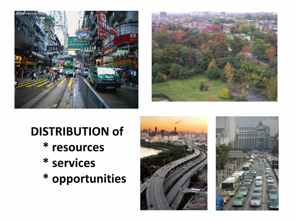
DISTRIBUTION of * resources * services * opportunities

Social Justice
Economic
Growth
Triangle axis 1:THE PROPERTY CONFLICT
ARISES from: competing claims on
and
uses of property
TENSION is between : private sector
& social intervention

Triangle axis 1: THE PROPERTY CONFLICT
private interest the public good
Environmental Protection
Economic
Growth
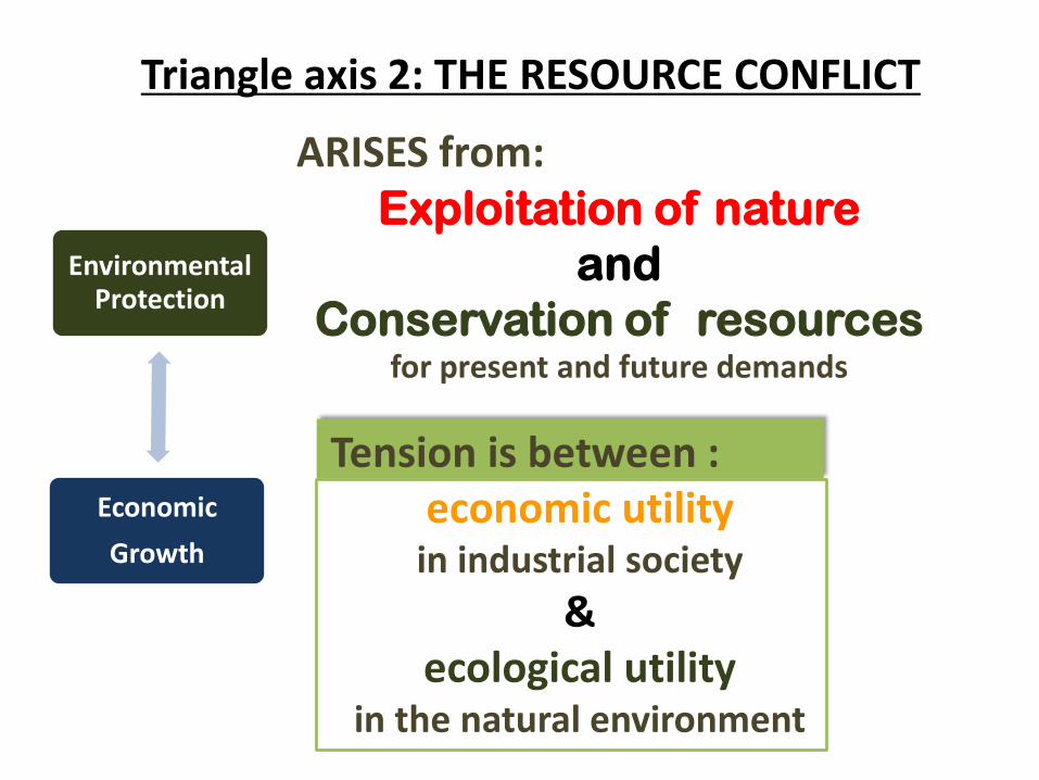
Triangle axis 2: THE RESOURCE CONFLICT
ARISES from: Exploitation of nature
and
Conservation of resources for present and future demands
Tension is between : economic utility
in industrial society
& ecological utility
in the natural environment

ecological utility in the natural environment
economic utility in industrial society
VS

Triangle axis 2:THE PROPERTY CONFLICT
Developed City
Undeveloped Wilderness

Social Justice
Environmental Protection
Triangle axis 3: THE DEVELOPMENT CONFLICT
ARISES from: Social Equity
and
Environmental Preservation
TENSION is between :
Inequitable development &
protection of the environment

How to increase social equity
and protect the environment simultaneously, whether in a steady-state economy or not ?
Triangle axis 3: THE DEVELOPMENT CONFLICT
How could those at the bottom of society
find greater economic opportunity if environmental protection
mandates diminished economic growth?
haves
have-nots
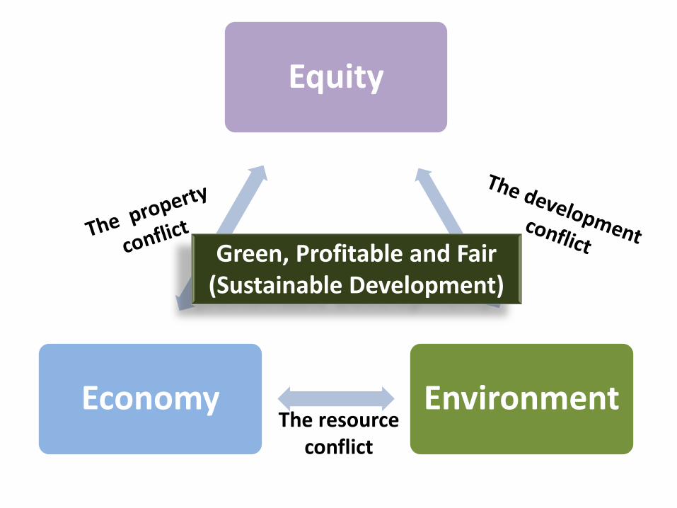
Equity
Environment Economy The resource
conflict
Green, Profitable and Fair (Sustainable Development)

The Path Towards Sustainable Development
How are you going to get there?
What are the negative consequences?
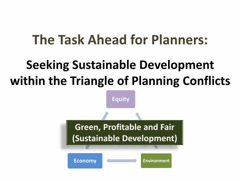
The Task Ahead for Planners:
Seeking Sustainable Development within the Triangle of Planning Conflicts
Equity
Environment Economy
Green, Profitable and Fair (Sustainable Development)

• understand opponent's interests and values
• express fundamental conflicts of interest
• Imbalance of power
Procedural Paths : Conflict Negotiation

Procedural Paths: Redefine the Language of Conflict
• Assisting to understand others priorities and reasoning
• One language will dominate the debate

• Conceptual level
– Words to be understandable by others
• Empirical level
– data collection
– Integrate different analysis scales
Procedural Paths: Redefine the Language of Conflict
Social word

Other Procedural Paths
• Political pluralism
• Develop market mechanisms
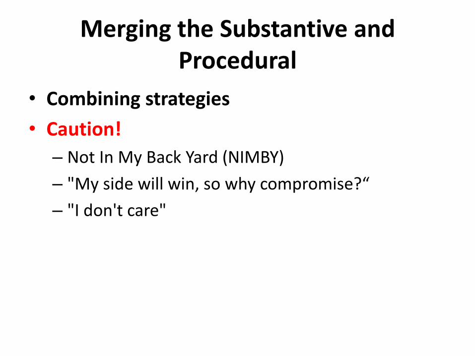
Merging the Substantive and Procedural
• Combining strategies
• Caution!
– Not In My Back Yard (NIMBY)
– "My side will win, so why compromise?“
– "I don't care"

Planners: Leaders or Followers?
• TAKE THE LEAD in resolving such conflicts
• IF NOT, must EXPLOIT those areas of conflict where they have the greatest leverage and expertise
• SEEK to resolve both environmental and economic equity issues at once

Planners Decision?
• “Planners will have to decide whether they want to remain outside the conflict and act as MEDIATORS, or jump into the fray
and PROMOTE their OWN visions of ecological-economic development, sustainable or otherwise. “
• Both planning behaviors are needed.

THANKS FOR LISTENING AND WELCOME YOUR COMMENTS!

Principles of Livable Towns
and Cities
Eduardo F. Bober, Jr. Industry Lecturer
10
Source: RDP_4A_NEDA Report

Design on a Human Scale
Compact, pedestrian-friendly communities allow residents to walk to shops, services, cultural resources, and jobs, and can reduce traffic congestion and benefit peoples’ health.

Provide Choices
People prefer variety in housing, shopping, recreation, transportation and employment. Variety creates lively neighborhoods and accommodates residents in different stages of their lives.

Encourage Mixed-Use Development
Integrating land uses , neighborhood of varying social classes, and varied building types create vibrant, pedestrian-friendly, diverse communities

Preserve Urban Centers
Restoring, revitalizing, and in-filling urban centers take advantage of existing streets, services, and buildings, and avoid the need for new infrastructure. This helps curb “sprawl” and promote stability for city neighborhoods.
4

Vary Transportation Options
Giving people the option of walking, biking, and using public transit in addition to driving, reduces traffic congestion, protects the environment and encourages physical activity.
5

Build Vibrant Public Spaces
Citizens need welcoming, well-defined public spaces to stimulate face-to-face interaction, collectively celebrate and mourn, encourage civic participation, admire public art, and gather for public events.

Create a Neighborhood Identity A “sense of place” gives neighborhoods,
barangays and communities a unique character, enhances the walking environment, and creating pride within the community.
7

Protect Environmental Resources A well-designed balance of nature and
development preserves ecological systems, protects waterways from contamination, reduces air pollution and protects property values.
8

Conserve Landscapes
Open space, farms, and wildlife habitat are essential for environmental, recreational, and cultural reasons
9

Design Matters
Design excellence is the foundation of attractive, successful, and healthy communities. The urban and landscape design will also define what communities value.
10

Thank you for listening.


![[Tax 2] Midterm Reviewer](https://img.pdfslide.net/doc/110x75/55cf8df2550346703b8cf003/tax-2-midterm-reviewer.jpg)