Embed Size (px)
Citation preview

PLANNING & ZONING BOARD
STAFF REPORT DEVELOPMENT SERVICES DEPARTMENT
100 NW 1ST AVENUE, DELRAY BEACH, FLORIDA 33444 PLANNING & ZONING DIVISION: (561) 243-7040 • BUILDING DIVISION: (561) 243-7200
IK;
PAGE | 1
Project Planner:
Jasmin Allen, Senior Planner [email protected], 561.243.7044
Board Review Dates: Planning and Zoning Board, October 15, 2018 City Commission: City Commission Schedule is attached as Exhibit B,
Attachments:
Listed at the end of the Staff Report
PPrreesseerrvvee AAmmeerriiccaa CCoommmmuunniittyy ssiinnccee 22000088
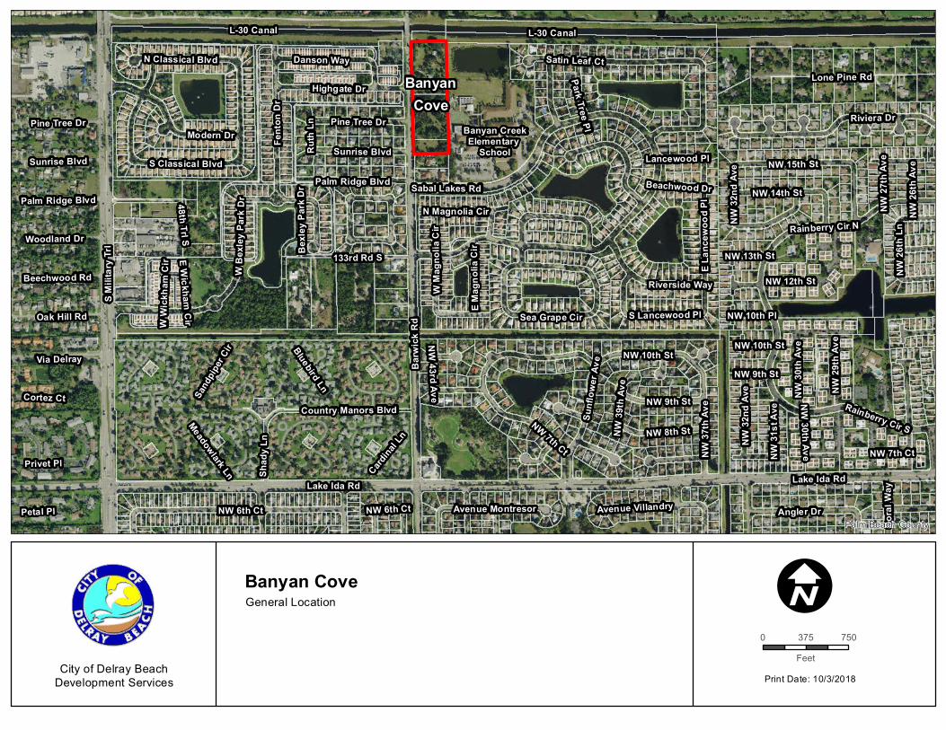
Banyan Cove: Privately-initiated petition for Voluntary Annexation, Future Land Use Map Amendment re-
designating from Palm Beach County Medium Density Residential 5 (MR-5) dwelling units per acre (du/ac)
to City Medium Density (MD) Residential 5-12 du/ac; and, Rezoning and re-designating the zoning district
from Palm Beach County Agricultural Residential (AR) in part and Residential High (RH) in part and
establishing a City zoning of Medium Density Residential (RM) for three parcels of land located on the east
side of Barwick Road, immediately south of the Lake Worth Drainage District (LWDD) L-30 Canal.
Planning and Zoning Board: October 15, 2018
File No.: 2018-
162 & 2018-163
Application Type: Annexation, Future
Land Use Map Amendment and
Rezoning
Request: Provide a recommendation to the City Commission regarding a privately-initiated petition for
voluntary annexation, Future Land Use Map amendment re-designating from Palm Beach County Medium
Density Residential 5 units per acre (MR-5) to City Medium Density Residential 5-12 du/ac (MD); and,
rezoning and re-designating the zoning district from Palm Beach County Agricultural Residential (AR) in
part and Residential High (RH) in part and establishing a City zoning of Medium Density Residential (RM)
for three parcels of land located on the east side of Barwick Road, immediately south of the Lake Worth
Drainage District (LWDD) L-30 Canal. Pursuant to Land Development Regulations (LDR) Section 2.2.2(E)
(6), the Local Planning Agency (Planning & Zoning Board) shall review and make a recommendation to the
City Commission with respect to Annexation, Future Land Use Map Amendment and Rezoning petitions.
Recommendation: By Separate Motions:
1. Recommend approval to the City Commission for the Annexation of the subject property, by adopting
the findings of fact and law contained in the staff report, and finding that the request and approval
thereof is consistent with F.S. 171.044, in that the property is contiguous to the City, reasonably
compact and does not create an enclave; consistent with the Comprehensive Plan and meets the
criteria set forth in Sections 2.4.5 (C) of the Land Development Regulations.
2. Recommend approval to the City Commission for the small scale FLUM Amendment re-designating
from Palm Beach County Medium Density Residential 5 du/ac (MR-5) to City Medium Density
Residential 5-12 du/ac (MD); for the subject property, by adopting the findings of fact and law contained
in the staff report, and finding that the request and approval thereof is consistent with the
Comprehensive Plan and meets the criteria set forth in Sections 2.5.5(A) and 3.1.1 of the Land
Development Regulations.
3. Recommend approval to the City Commission re-designating the zoning district from Palm Beach
County Agricultural Residential (AR) in part and Residential High (RH) in part and establishing a City
zoning of Medium Density Residential 6 du/ac (RM-6) for the subject property, by adopting the findings
of fact and law contained in the staff report, and finding that the request and approval thereof is
consistent with the Comprehensive Plan and meets the criteria set forth in Sections 2.4.5(D)(5), 3.1.1
and 3.2.2 of the Land Development Regulations.
PLANNING & ZONING BOARD STAFF REPORT
IK;
Page | 2
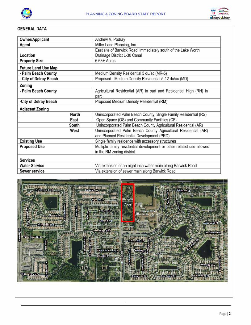
GENERAL DATA
Owner/Applicant Andrew V. Podray
Agent Miller Land Planning, Inc.
Location
East site of Barwick Road, immediately south of the Lake Worth Drainage District L-30 Canal
Property Size 6.68± Acres
Future Land Use Map
- Palm Beach County Medium Density Residential 5 du/ac (MR-5)
- City of Delray Beach Proposed - Medium Density Residential 5-12 du/ac (MD)
Zoning
- Palm Beach County Agricultural Residential (AR) in part and Residential High (RH) in part
-City of Delray Beach Proposed Medium Density Residential (RM)
Adjacent Zoning
North Unincorporated Palm Beach County, Single Family Residential (RS)
East Open Space (OS) and Community Facilities (CF)
South Unincorporated Palm Beach County Agricultural Residential (AR)
West Unincorporated Palm Beach County Agricultural Residential (AR) and Planned Residential Development (PRD)
Existing Use Single family residence with accessory structures
Proposed Use Multiple family residential development or other related use allowed in the RM zoning district
Services
Water Service Via extension of an eight inch water main along Barwick Road
Sewer service Via extension of sewer main along Barwick Road
PLANNING & ZONING BOARD STAFF REPORT
Page | 3
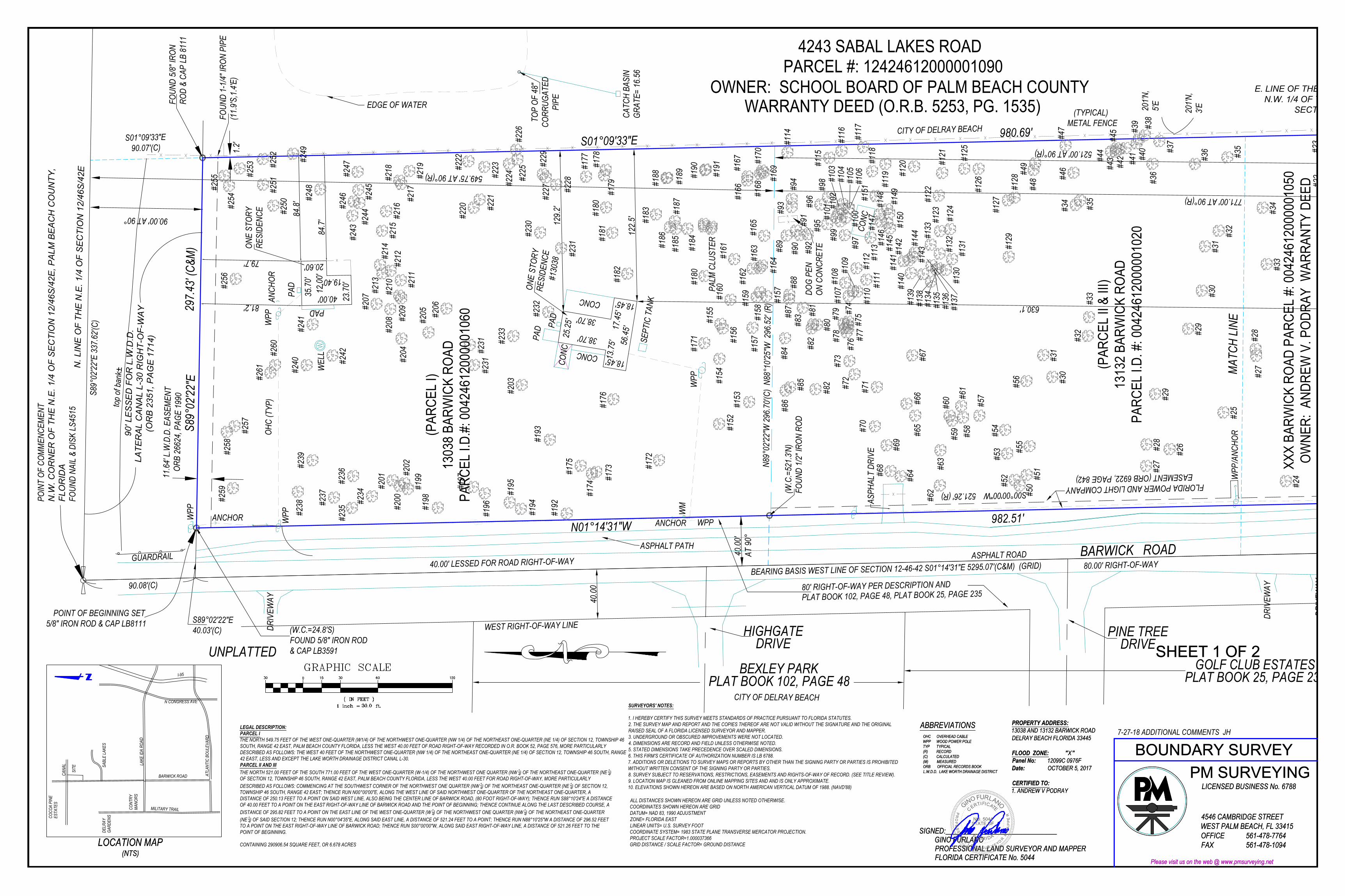
REVIEW AND ANALYSIS Background/Project Description: Banyan Cove is bordered to the north by Canal LWDD L-30; to the east by the Banyan Creek Elementary School; to the south by single family residences located in unincorporated Palm Beach County (north side of Sabal Lakes Road); and to the west by Bexley Park, a Planned Residential Development (PRD) located within the City of Delray Beach; as well as a single family subdivision known as Golf Club Estates and a single family residence (located south of the L-30 Canal) all located within unincorporated Palm Beach County. The subject property encompasses three parcels and is identified by property control numbers: 00-42-46-12-00-000-1020, 00-42-46-12-00-000-1050, and 00-42-46-12-00-000-1060. The subject property measures approximately 6.68± acres. A single family residence with accessory structures is located on the northernmost parcel and the remaining two parcels are vacant. Several requests have been made to the City pertaining to the annexation of the subject property. The following outlines the annexation requests processed by the City. South 3.54 acre parcels (PCN 00-42-46-12-00-000-1020 & 00-42-46-12-00-000-1050) March 17, 1997: The Planning and Zoning Board considered requests for Annexation, Future Land Use Map amendment, and zoning of Medium Density Residential (RM) and recommended that the requests be approved with an initial zoning of Medium Density Residential - 8 du/ac (RM-8). The petitions were withdrawn prior to final action by the City Commission. Subsequently on June 2, 2000, application requests for Annexation, Future Land Use Map amendment, and zoning of Community Facilities (CF), and a conditional use for the expansion of the Pathway to Recovery Facility were submitted. On August 21, 2000, the Planning and Zoning Board recommended approval of the Annexation and Small-Scale Future Land Use Map amendment re-designating from Palm Beach County MR-5 to City CF, with azoning designation of CF for Pathways to Recovery, Inc. On October 3, 2000, the City Commission denied the Annexation, Small-Scale Future Land Use Map amendment, and Rezoning requests that were submitted on August 21, 2000. Subsequently, the buildings were demolished and the site has remained vacant. North 3.13 acre parcel (PCN 00-42-46-12-00-000-1060) On March 19, 2012, the Planning and Zoning Board considered requests for recommended Annexation, FLUM amendment re-designating from Palm Beach County MR-5 to City MD, and re-designating the zoning district from Palm Beach County AR to City Agricultural (A). The Board recommended approval to the City Commission of the requested petitions. On March 20, 2012, Palm Beach County Planning Department issued a letter of objection to the annexation contending that the proposed annexation would create an enclave. The application did not move forward to the City Commission. On June 8, 2012, a Water Service Agreement was approved to provide City water services for the property, for the use of the single family residential structure. On July 13, 2018, a voluntary annexation petition, Future Land Use Map amendment, and Rezoning requests were submitted for all three parcels. The application states “In 2018, MLP (Miller Land Planning), on behalf of the applicant, has filed applications for a land use amendment and rezoning of the property through Palm Beach County for residential density of 8 units per acre which would allow for 53 units of multi-family residential development. Through that process, discussions continued with the City of Delray Beach about the procedures for future annexation of the property
PLANNING & ZONING BOARD STAFF REPORT
Page | 4
into the City. Through the involvement of the City Manager, City Attorney and City Planning & Zoning Director, it has been determined that the Florida Statutes allows for the voluntary annexation of this property and reduces the enclave area remaining in Palm Beach County. Based on that determination, this application requests concurrent approval of voluntary annexation from Palm Beach County to the City of Delray Beach, implementation of the land use designation from Medium Residential 5 u/a (MR-5 Palm Beach County) to Medium Density (MD) Residential 5 - 12 u/a (City) and initial zoning from AR and RH (Palm Beach County) to Medium Density Residential (RM - City). No formal site plan application is being submitted at this time but acknowledged that a formal Site Plan application will be required for the proposed development prior to issuance of development permits.”….”This application requests the annexation, land use amendment to MD at 8 units per acre, and corresponding zoning of RM. Approval of this application will allow for a future site plan application and development of multiple family residential or related development allowed by RM zoning district.”
ANNEXATION ANALYSIS Florida Statutes Governing Voluntary Annexations: Pursuant to the Florida Statutes 171.044, "the owner or owners of real properties in an unincorporated area of the County, which is contiguous to a municipality and reasonably compact, may petition the governing body of said municipality that said property be annexed to the municipality". The voluntary annexation was submitted by Miller Land Planning, agent, on behalf of Andrew V. Podray, the property owner of record. The parcels are contiguous to the City of Delray Beach along the east property line which extends a total of 980.69’. The subject properties are compact as all three parcels abut one another and measure 297.43’ x 980.69’. Pursuant to F.S. 171.044 (5) "land shall not be annexed through voluntary annexation when such annexation results in the creation of enclaves". F.S. 171.031, Definitions – (13) “Enclave” means:
(a) Any unincorporated improved or developed area that is enclosed within and bounded on all sides by a single municipality; or
(b) Any unincorporated improved or developed area that is enclosed within and bounded by a single municipality and a natural or manmade obstacle that allows the passage of vehicular traffic to that unincorporated area only through the municipality.
Florida Statutes allows for the voluntary annexation that reduces an enclave area. With the annexation of the Bexley Park development, located on the west side of Barwick Road, that portion of the development that abuts Barwick Road was identified as Parcel “K”, PCN: 00-42-46-12-00-000-3180 in the adopted ordinance (please refer to the attached location map). Parcel “K” as described within Ordinance No. 31-02 excluded a portion of the Barwick Road right-of-way and is described as: 12-46-42 NE ¼ of NE ¼ of NW ¼ (less E 40 ft. Barwick Rd R/W, N 140 ft. L-30 Cnl /R/W & S 159 ft. of N 299 ft. of W 209 f.t of E 249 ft. Barwick Road is an 80 feet right-of-way. The west one-half (40’) of Barwick Road was not included in the annexation action. Therefore, the resulting impact maintains the continued passage of vehicular traffic to the unincorporated areas to the south through the County, thus the proposed action reduces the enclave area remaining in Palm Beach County.
Land Development Regulations Governing Annexations: Pursuant to the Land Development Regulations 2.4.5 (C)(1), “the owner of land may seek the annexation of contiguous property, under his ownership” pursuant to Florida Statutes. The voluntary annexation petition was submitted by Andrew V. Podray, property owner, in accordance with Chapter 171, Florida Statutes and the subject property is contiguous to the City of Delray Beach as noted above.
PLANNING & ZONING BOARD STAFF REPORT
Page | 5
Consistency With The City’s Comprehensive Plan: Upon adoption of the 1989 Comprehensive Plan, the City’s “reserve annexation area” was replaced by the boundaries of its “Official Planning Area”. The Official Planning Area is the area for which most calculations and projections in which the City’s Comprehensive Plan are predicated upon. It is also considered the City’s ultimate boundaries. The Planning Area is specifically delineated on Map #1, Future Land Use Element. Designated Annexation Areas The territory to be annexed is located within designated Annexation Area “E” (North Military Trail/Barwick Road Area) as identified in the Future Land Use Element of the Comprehensive Plan. Annexation of the subject territory is consistent with the Future Land Use Element Policy B-3.5, which calls for annexation of eligible properties through voluntary annexations as the opportunities arise. Provision of Services When annexation of property occurs, services are to be provided in a manner which is consistent with services provided to other similar properties already in the City (Future Land Use Element Policy B-3.1). The provision of services with respect to Public Safety and Emergency Services is provided below. Other services with respect to concurrency is addressed under the Future Land Use Analysis portion of this report.
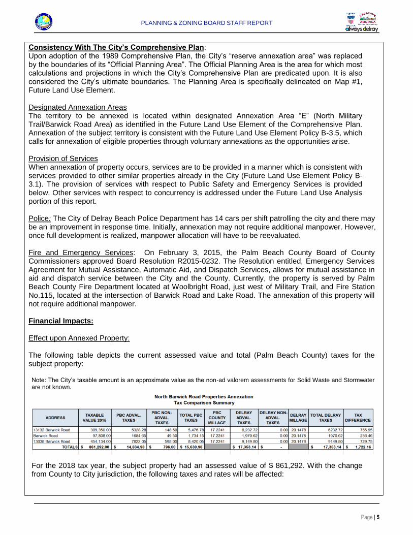
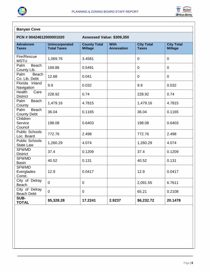
Police: The City of Delray Beach Police Department has 14 cars per shift patrolling the city and there may be an improvement in response time. Initially, annexation may not require additional manpower. However, once full development is realized, manpower allocation will have to be reevaluated. Fire and Emergency Services: On February 3, 2015, the Palm Beach County Board of County Commissioners approved Board Resolution R2015-0232. The Resolution entitled, Emergency Services Agreement for Mutual Assistance, Automatic Aid, and Dispatch Services, allows for mutual assistance in aid and dispatch service between the City and the County. Currently, the property is served by Palm Beach County Fire Department located at Woolbright Road, just west of Military Trail, and Fire Station No.115, located at the intersection of Barwick Road and Lake Road. The annexation of this property will not require additional manpower. Financial Impacts: Effect upon Annexed Property: The following table depicts the current assessed value and total (Palm Beach County) taxes for the subject property: Note: The City’s taxable amount is an approximate value as the non-ad valorem assessments for Solid Waste and Stormwater are not known.
For the 2018 tax year, the subject property had an assessed value of $ 861,292. With the change from County to City jurisdiction, the following taxes and rates will be affected:
PLANNING & ZONING BOARD STAFF REPORT
Page | 6
Banyan Cove
PCN # 00424612000001020 Assessed Value: $309,350
Advalorem Taxes
Unincorporated Total Taxes
County Total Millage
With Annexation
City Total Taxes
City Total Millage
Fire/Rescue MSTU
1,069.76 3.4581
0 0
Palm Beach County Lib.
169.86 0.5491
0 0
Palm Beach Co. Lib. Debt
12.68 0.041
0 0
Florida Inland Navigation
9.9 0.032
9.9 0.032
Health Care District
228.92 0.74
228.92 0.74
Palm Beach County
1,479.16 4.7815
1,479.16 4.7815
Palm Beach County Debt
36.04 0.1165
36.04 0.1165
Children Service Council
198.08 0.6403
198.08 0.6403
Public Schools Loc. Board
772.76 2.498
772.76 2.498
Public Schools State Law
1,260.29 4.074
1,260.29 4.074
SFWMD District
37.4 0.1209
37.4 0.1209
SFWMD Basin
40.52 0.131
40.52 0.131
SFWMD Everglades Const.
12.9 0.0417
12.9 0.0417
City of Delray Beach
0 0
2,091.55 6.7611
City of Delray Beach Debt
0 0
65.21 0.2108
SUB-TOTAL
$5,328.28 17.2241 2.9237 $6,232.72 20.1478
PLANNING & ZONING BOARD STAFF REPORT
Page | 7
PCN # 00424612000001050 Assessed Value: $97,808
Advalorem Taxes
Unincorporated Total Taxes
County Total Millage
With Annexation
City Total Taxes
City Total Millage
Fire/Rescue MSTU
338.23 3.4581
0 0
Palm Beach County Lib.
53.71 0.5491
0 0
Palm Beach Co. Lib. Debt
4.01 0.041
0 0
Florida Inland Navigation
3.13 0.032
3.13 0.032
Health Care District
72.38 0.74
72.38 0.74
Palm Beach County
467.67 4.7815
467.67 4.7815
Palm Beach County Debt
11.39 0.1165
11.39 0.1165
Children Service Council
62.63 0.6403
62.63 0.6403
Public Schools Loc. Board
244.32 2.498
244.32 2.498
Public Schools State Law
398.47 4.074
398.47 4.074
SFWMD District
11.82 0.1209
11.82 0.1209
SFWMD Basin 12.81 0.131
12.81 0.131
SFWMD Everglades Const.
4.08 0.0417
4.08 0.0417
City of Delray Beach
0 0
661.29 6.7611
City of Delray Beach Debt
0 0
20.62 0.2108
SUB-TOTAL
1,684.65 17.2241 2.9237 1,970.62 20.1478
PLANNING & ZONING BOARD STAFF REPORT
Page | 8
PCN # 00424612000001060
Assessed Value: $454,134
Advalorem Taxes
Unincorporated Total Taxes
County Total Millage
With Annexation
City Total Taxes
City Total Millage
Fire/Rescue MSTU
1,570.44 3.4581
0 0
Palm Beach County Lib.
249.36 0.5491
0 0
Palm Beach Co. Lib. Debt
18.62 0.041
0 0
Florida Inland Navigation
14.53 0.032
14.53 0.032
Health Care District
336.06 0.74
336.06 0.74
Palm Beach County
2,171.44 4.7815
2,171.44 4.7815
Palm Beach County Debt
52.91 0.1165
52.91 0.1165
Children Service Council
290.78 0.6403
290.78 0.6403
Public Schools Loc. Board
1,134.43 2.498
1,134.43 2.498
Public Schools State Law
1,850.14 4.074
1,850.14 4.074
SFWMD District
54.9 0.1209
54.9 0.1209
SFWMD Basin 59.49 0.131
59.49 0.131
SFWMD Everglades Const.
18.94 0.0417
18.94 0.0417
City of Delray Beach
0 0
3,070.45 6.7611
City of Delray Beach Debt
0 0
95.73 0.2108
SUB-TOTAL
7,822.05 17.2241 2.9237 9,149.80 20.1478
TOTAL $14,834.98
$17,353.14
The total tax millage for Palm Beach County is 17.2241 mills while the total millage for the City of Delray Beach is 20.1478 mills. Under Palm Beach County jurisdiction, the current yearly ad valorem taxes for all three parcels are $14,834.98. With annexation, the yearly ad valorem taxes for all three parcels will be $17,353.14, a tax difference of $2,518.16.
PLANNING & ZONING BOARD STAFF REPORT
Page | 9
The following Non Ad Valorem taxes will continue to be applied to the property: Solid Waste Authority: The Barwick Road area is serviced under a contract by Waste Management (pursuant to a contract awarded in 2015). Pursuant to Florida Statute 171.062(4)(a) “if a party has an exclusive franchise which is in effect for at least six months prior to the initiation of an annexation, the franchise may continue to provide such services to the annexed area for five years or the remainder of the franchise term whichever is shorter”. Thus, the waste service provider will not change with annexation. Lake Worth Drainage District: The Lake Worth Drainage District manages the water resources in southeast Palm Beach County and is supported by an annual non-ad valorem assessment. This fee will remain the same with annexation.
The following new non-ad valorem tax will apply upon annexation: Delray Beach Stormwater Utility: This assessment is based upon the percentage of impervious area of the structures, buildings, parking areas, etc. For the existing single family residence a stormwater assessment will be applied based on an equivalent residential unit (ERU) x 12 months. If the property is developed as multiple family, the calculation will be based on the total square feet of impervious area / 2502 x 1 ERU x 12months. A 25% discount from the assessment is available since the property is within the Lake Worth Drainage District. An additional 25% may be available if drainage is retained on site. With annexation, stormwater assessments will made based on the current use of the property, however the assessment will be modified once the property is developed. Fiscal Impacts to the City: At the 2018/2019 City operating millage of 6.7611 mills and debt rate of 0.2108 mills, the property will generate approximately $17,353.14 in new ad valorem taxes per year. Additional revenues will be realized through the annual collection of the storm water assessment fee as well as Communication Service Tax (Cable and Telephone of 5.22%); Electric and Gas Tax of 10% and Utility Franchise Fee on Electric of 6%. Accommodating the annexation of this property is consistent with the City's program for annexation of territory within its planning and service area and is consistent with Policy B 3.5 , Future Land Use Element which supports the accommodation of voluntary annexations as the opportunities arise . FUTURE LAND USE MAP AMENDMENT ANALYSIS
Current Land Use Designation: The current Palm Beach County Future Land Use Map designation for the property is MR-5. The City's FLUM designations as initially contained on the City's Future Land Use Map adopted in November, 1989, (and as formally amended subsequently) are deemed to be advisory until an official Land Use Amendment is processed. The current City “advisory” designation is MD. Requested Land Use Designation: The requested Future Land Use Map Designation is City MD. The proposed FLUM amendment is being processed as a small-scale Comprehensive Plan amendment. Florida Statutes F.S. 163.3187 provides that a small-scale development amendment may be adopted under the following conditions:
(a) The proposed amendment involves a use of 10 acres or fewer; (b) The cumulative annual effect of the acreage for all small scale development amendments
adopted by the local government does not exceed a maximum of 120 acres in a calendar year;
PLANNING & ZONING BOARD STAFF REPORT
Page | 10
(c) The proposed amendment does not involve a text change to the goals, policies, and objectives of the local government’s comprehensive plan, but only proposes a land use change to the future land use map for a site-specific small scale development activity.
However, text changes that relate directly to, and are adopted simultaneously with, the small scale future land use map amendment shall be permissible under this section;
(d) The property that is the subject of the proposed amendment is not located within an area of critical state concern, unless the project subject to the proposed amendment involves the construction of affordable housing units meeting the criteria of s.420.0004(3), and is located within an area of critical state concern designated by s.380.0552 or by the Administration Commission pursuant to s. 380.05(1).
This is the second amendment for 2018. The first amendment involved a 0.137 acre parcel. As the subject property consists of 6.68± acres, the maximum of 120 acres has not been exceeded. The proposed FLUM amendment does not involve a text change to the Goals, Policies, or Objectives of the Comprehensive Plan. The requested FLUM amendment is for a site-specific parcel of land. The subject property is not located within an area of critical state concern. Thus, the proposed FLUM amendment can be processed as a small scale amendment because it complies with all of the above conditions. The proposed land use change is being processed in conjunction with a petition for annexation. The requested zoning district is Medium Density Residential (RM) at a density of eight units per acre to accommodate 53 multi-family residential dwelling units. Future Land Use Element, of the Comprehensive Plan, Table L-6, identifies which zoning districts are consistent with the Future Land Use Map designations. Pursuant to Table L-6, the proposed MD FLUM designation and the proposed RM zoning district are consistent. Pursuant to LDR Section 3.1.1, Required Findings, prior to approval of Land Use applications, certain findings must be made in a form which is part of the official record. This may be achieved through information on the application, written materials submitted by the applicant, the staff report, or minutes. Findings shall be made by the body which has the authority to approve or deny the development application. These findings relate to the Future Land Use Map (FLUM), Concurrency, Comprehensive Plan Consistency, and Compliance with the Land Development Regulations. Pursuant to LDR Section 3.1.1(A), Future Land Use Map, the resulting use of land or structures must be allowed in the zoning district within which the land is situated and said zoning must be consistent with the applicable land use designation as shown on the Future Land Use Map. Policy A-1.7 Amendments to the Future Land Use Map (FLUM) must be based upon the findings listed below, and must be supported by data and analysis that demonstrate compliance with these findings:
Demonstrated Need -- That there is a need for the requested land use. The need must be based
upon circumstances such as shifts in demographic trends, changes in the availability of land, including but not limited to the minimum amount of land required to accommodate the medium population projections as published by the Office of Economic and Demographic Research for at least a 10-year planning period, changes in the existing character and FLUM designations of the surrounding area, fulfillment of a comprehensive plan objective or policy, annexation into the municipal boundaries, or similar circumstances. The need must be supported by data and analysis verifying the changing demographics or other circumstances. This requirement shall not apply to requests for the FLUM designations of Conservation or Recreation and Open Space; nor shall it apply to FLUM changes associated with annexations when the City’s advisory FLUM designation is being applied, or when the requested designation is of a similar intensity to the
PLANNING & ZONING BOARD STAFF REPORT
Page | 11
advisory designation. However, the findings described in the remainder of this policy must be addressed with all FLUM amendments.
Applicant’s Comments: As indicated directly within the policy (and highlighted above in bold for emphasis), this requirement does not apply to applications associated with annexations when applying the City’s advisory FLUM designation. As shown in the graphic above, the Future Land Use Map shows this site with a MD land use designation which is also being requested with the annexation. Accordingly this requirement is not applicable. Staff Comments: Assignment of a City FLUM designation of MD (upon annexation) would not require a finding with respect to “demonstrated need”; however, as noted above, the findings described in the remainder of this policy (i.e. Consistency, Concurrency, Compatibility, and Compliance with the Land Development Regulations) need to be addressed. The City’s MD FLUM designation as described in the Future Land Use Element states as follows: “Residential Land Uses: Medium Density – This designation is applied to land which is developed, or is to be developed, at a density between five and twelve units per acre. Residential density is limited to a maximum of 12 dwelling units per acre, except within the portion of the Southwest Neighborhood Area Overlay District lying between the commercial area along West Atlantic Avenue and SW 2nd Street (SW 3rd Street along SW 12th Avenue), from Swinton Avenue to Interstate 95, where the density may exceed 12 units per acre, up to a maximum of 24 units per acre subject to Conditional Use approval and the recommendations and strategies outlined in the Southwest Area Neighborhood Redevelopment Plan. Areas with this designation, located within a workforce housing overlay district, may also exceed 12 units per acre, up to a maximum of 24 units per acre within the Carver Estates Overlay District and 18 units per acre within other overlay districts by obtaining density bonuses through the provision of workforce housing units. Such land is usually developed in planned communities or exists in older areas where there are duplexes and condominiums. Home ownership is characteristic of this designation. Where this designation exists, uses other than those which are residential in character shall not be considered.” The subject property is not located within a workforce housing overlay district and, therefore, the maximum density allowed under the MD FLUM designation is 12 dwelling units per acre. As the request maintains the advisory MD FLUM designation, this in keeping with requirements of the demonstrated need for the requested change.
Consistency -- The requested designation is consistent with goals, objectives, and policies of the
most recently adopted Comprehensive Plan: The following highlights the applicable Objectives and Policies within the City of Delray Beach Comprehensive Plan
Applicant’s Comments: “Objective B-3 of the Comprehensive Plan addresses annexation of properties. Policy B-3.1 and B-3.2 confirm that services such as fire protection, code enforcement and water and sewer facilities shall be provided to those properties anticipated for annexation. Policy B-3.3 and B-3.4 state that the FLUM designation as shown on the City's Future Land Use Map "shall be in effect immediately upon annexation of a specific parcel". For the subject site, as shown above, the Future Land Use designates this site with the MD land use designation. Accordingly, this application is consistent with the policy and should be immediately effective upon approval of the annexation.” Staff Comments: Policy B-3.3 (Future Land Use Element) of the Comprehensive Plan addresses unincorporated parcels which are located within the City’s Planning Area and states: “Within the Delray Beach Planning Area, the City's FLUM designation shall be in effect immediately upon annexation of a specific parcel.
PLANNING & ZONING BOARD STAFF REPORT
Page | 12
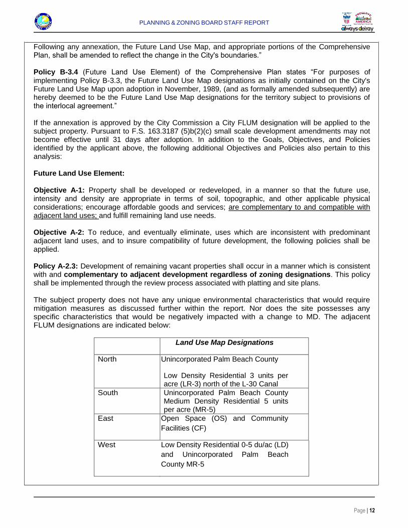
Following any annexation, the Future Land Use Map, and appropriate portions of the Comprehensive Plan, shall be amended to reflect the change in the City's boundaries.” Policy B-3.4 (Future Land Use Element) of the Comprehensive Plan states “For purposes of implementing Policy B-3.3, the Future Land Use Map designations as initially contained on the City's Future Land Use Map upon adoption in November, 1989, (and as formally amended subsequently) are hereby deemed to be the Future Land Use Map designations for the territory subject to provisions of the interlocal agreement.” If the annexation is approved by the City Commission a City FLUM designation will be applied to the subject property. Pursuant to F.S. 163.3187 (5)b(2)(c) small scale development amendments may not become effective until 31 days after adoption. In addition to the Goals, Objectives, and Policies identified by the applicant above, the following additional Objectives and Policies also pertain to this analysis: Future Land Use Element: Objective A-1: Property shall be developed or redeveloped, in a manner so that the future use, intensity and density are appropriate in terms of soil, topographic, and other applicable physical considerations; encourage affordable goods and services; are complementary to and compatible with adjacent land uses; and fulfill remaining land use needs. Objective A-2: To reduce, and eventually eliminate, uses which are inconsistent with predominant adjacent land uses, and to insure compatibility of future development, the following policies shall be applied. Policy A-2.3: Development of remaining vacant properties shall occur in a manner which is consistent with and complementary to adjacent development regardless of zoning designations. This policy shall be implemented through the review process associated with platting and site plans. The subject property does not have any unique environmental characteristics that would require mitigation measures as discussed further within the report. Nor does the site possesses any specific characteristics that would be negatively impacted with a change to MD. The adjacent FLUM designations are indicated below:
Land Use Map Designations
North Unincorporated Palm Beach County
Low Density Residential 3 units per acre (LR-3) north of the L-30 Canal
South Unincorporated Palm Beach County Medium Density Residential 5 units per acre (MR-5)
East Open Space (OS) and Community
Facilities (CF)
West Low Density Residential 0-5 du/ac (LD)
and Unincorporated Palm Beach
County MR-5
PLANNING & ZONING BOARD STAFF REPORT
Page | 13
With any Future Land Use Map amendment, the resulting use of land or structures must be allowed in the zoning district within which the land is situated and said zoning must be consistent with the applicable land use designation as shown on the Future Land Use Map. Any change to a FLUM designation requires that further analysis with respect to the resulting use of land or structures, and that such use must be allowed in a zoning district that is consistent with FLUM designation. Multi-family residential use is consistent with the MD FLUM designation. While the request is consistent with the City’s advisory MD FLUM specific conditions will be warranted to ensure the increase in density and related intensity is appropriate and complimentary to the surrounding neighborhoods and this will be further addressed in the Zoning Analysis of the report. Objective B-2: Facilities and services which are provided by, or through, the City of Delray Beach shall be provided to new development concurrent with issuance of a Certificate of Occupancy pursuant to the following policies. Policy B-2.3: Prior to recommending approval of any land use application which comes before it, the Local Planning Agency, or appropriate approving body, must make a finding of consistency with this objective and its supporting policies. If such a finding cannot be made, either conditions shall be made which provide for concurrency or the land use request shall be denied. This objective and supporting policies are addressed under the Concurrency portion of this analysis.
Housing Element: Objective A-3: For those areas identified as “stable residential” on the Residential Neighborhood Categorization Map, the City shall implement the following policies to ensure that they remain “stable residential” and do not decline. Policy A-3.1: Each area of the City that is identified as “stable residential” shall be included within a neighborhood association which has an official representation. The purpose and implementation of this policy is as provided in Objective A-1 and its related policies. Policy A-3.2: The most restrictive residential zoning district that is applicable given existing development patterns and typical lot sizes shall be applied to these neighborhoods and affixed to the zoning map. Requests for rezonings to a different zoning designation, other than Community Facilities, Open Space, Open Space and Recreation, or Conservation shall be denied. Staff Comments:
The Housing Element classifies neighborhoods as to their overall appearance, and condition of the
structures and infrastructure. Neighborhoods were identified in several categories:
Stable--No apparent signs of physical or other decline; no improvement needed. Needing Stabilization--Appearance of minor code violations and maintenance problems; some improvement desired. Needing Revitalization--Evidence of decline in condition of structures and yards; increase in crime; property values stagnant or declining. Needing Rehabilitation--Numerous code violations; deteriorated and non- maintained structures; high level of absentee ownership; significant crime problems; large number of vacant lots.
The subject property is located within an area designated as “stable” on the Residential Neighborhood Categorization Map (map attached). Based on Policy A-3.2, the assignment of a City zoning shall
PLANNING & ZONING BOARD STAFF REPORT
Page | 14
comply with the most restrictive residential zoning district that is applicable given existing development patterns and typical lot sizes. Conservation Element: Policy B-2.1: The submission of a biological survey and a habitat analysis shall accompany land use requests for plan amendments, rezonings, and site plan approval. However, the requirement shall not apply to small parcels, developed parcels, or where it is apparent that there are no such resources. Policy B-2.2: Whenever and wherever significant or sensitive flora and fauna communities are identified, plans shall be required to preserve the habitat to the extent feasible, or provide for mitigation if preservation is infeasible or inappropriate. A field review was conducted of the subject property to determine whether Policy B-2.1 and/or B-2.2 of the Comprehensive Plan were an issue. The property has a number of mature trees, in excess of four (4) inches DBH (Diameter at Breast Height). Those trees include Sabal Palms (Sabal palmetto), Southern Live Oaks (Quercus virginiana), Southern Slash Pines (Pinus elliotti), Orchid trees (Bauhinia spp.), Fishtail Palms (Caryota spp.), Rubber trees (Ficus elastica), Areca Palms (Dypsis lutescens), Bamboo clumps (Bambusa spp.), Mango trees (Mangifera indica) and Lychee trees (Litchi chinensis). Of the number of trees on the property, the Sabal Palms, Southern Live Oak and Southern Slash Pines indicate the property was once a remnant of a “Pine Flatwood”. Besides the trees, there would have been an understory of plants including but not limited to Saw Palmetto (Serenoa repens), Gallberry (Ilex glabra), Fetterbush (Lyonia lucida), Wax Myrtle (Myrica cerifera), Tarflower (Befaria racemosa) and Wiregrass (Arisida stricta). Those plant species are entirely absent. In their place is cultivated grass, primarily St. Augustine (Stenotophrum secundatum) but with a mix of Bahia (Bahia spp.), Sedges (Carex spp.), etc. The understory is now an improved field or even a “lawn”. In addition, the inclusion of ornamental trees, such as Orchid trees, Fishtail Palms, rubber trees, Areca Palms and Bamboo clumps, plus fruit trees, such as Mangoes and Lychees, indicate this has been somebody’s “backyard”. In the case of fauna, in the time that I was on the property, the only animal or bird observed was a flock of Peacocks and Peahens foraging throughout the grounds. (In fact there is a “dog pen” on the property, which contained food for them.) The Peacock is a domesticated bird species, not a native one. In conclusion, even though the property includes a number of mature trees, it does not constitute a total and complete ecosystem. A biological survey and a habitat analysis are not required based upon the existing conditions of the properties. However, conformance with respect to preservation of trees will be addressed during the site plan review process.
Concurrency: Development at the highest intensity possible under the requested designation
can meet the adopted concurrency standards. Concurrency with respect to traffic, water and sewer, drainage, parks and recreation and school capacity determination are evaluated below:
Applicant’s Comments:
“The subject property was previously subject to land use and zoning applications through Palm Beach
County, therefore, concurrency services for proposed development that exceeded the highest intensity
possible was evaluated and found to be sufficient for traffic capacity and school capacity.
Correspondence confirming these determinations is provided as an attachment to this application.
That application was later modified to allow a lesser development program however was not required to
re-evaluate the traffic or school impacts since they were sufficient at a greater amount of intensity.
Water and sewer service is available to the property through the City of Delray Beach, also documented and attached. With the annexation of the property into the City, there is no requirement for a water and sewer service agreement otherwise required if the property remains in the County. The water and sewer
PLANNING & ZONING BOARD STAFF REPORT
Page | 15
requirements for the specific development will be evaluated and confirmed at time of a Site Plan application. Likewise, fire and police services are available to the property and will also be confirmed at time of Site Plan application. Adequate services are available to serve the subject site as proposed.” Staff Comments: Streets and Traffic: The property can be accessed via Barwick Road. Barwick Road extends from West Atlantic Avenue on the south and terminates at Coconut Lane in the City of Boynton Beach to the north. The segment of Barwick Road that is located within the City’s Planning Area is under the jurisdiction of the City of Delray Beach for associated maintenance responsibility and will not change upon annexation. Barwick Road extending from the LWDD L-30 Canal to Lake Ida Road accommodates two-lanes (with turn lanes at intersections). The right-of-way of Barwick Road that abuts the subject property is 80 feet wide. With respect to traffic study the applicant states “ …the current traffic conditions at the peak hour times of the school, both morning and afternoon, create stacking and turning movement issues along Barwick Road and more particularly at the intersection with Sabal Lakes Road which is the only road to access the school. Although, the County has reviewed and approved a traffic study for the proposed applications for the subject site, the traffic concerns of the surrounding residents during the peak times of school traffic are real and need to be addressed by the School District, County and City.” A comparative traffic analysis was submitted by the Applicant, which addressed the most intense development potential of the site at both the existing and proposed zoning classifications. The study was prepared in accordance with Palm Beach County Unified Land Development Code, Traffic Performance Ordinance. The comparative traffic study reveals that under the maximum development potential of 12 units per acre (80 units) the daily traffic generation would be 532 tpd (trips per day) with 43 AM Peak and 50 PM peak hour trips would be anticipated. With the requested density of eight units per acre, the trips generated by the proposed 53 units would be 352 tpd, with 30 AM peak hour trips and 33 peak hour trips. The traffic study concludes that the estimated 352 trips per day and 30 AM peak hour trips and 33 PM peak hour trips at project build-out in 2022 and in conjunction with the required link analysis meets the requirements of Palm Beach County Traffic Performance Standards. A traffic concurrency determination has not yet been provided from Palm Beach County Traffic Division for the current proposal. However, a traffic approval letter was provided with the application for the 2017 Palm Beach County Land Use application request, which sought approval of 102 residential units. As the proposed density and corresponding units (53) is much less, staff does not anticipate a negative letter from Palm Beach County Traffic Division.
The City’s consultant’s reviewed the submitted traffic study and indicates that the proposed development will have a “significant” impact on Barwick Road between the site and Lake Ida Road, with “significant” defined as adding more than one percent of the adopted level of service volume to the roadway. It should be noted that the project will add 17 peak hour trips to the road (i.e. one trip approximately every four minutes). The impact will not reduce the level of service, as Barwick has excess capacity allowing for additional growth of over 200 peak hour trips in the morning peak hour and over 300 peak hour trips in the evening peak hour. The project will not significantly impact any other roads in the area. Furthermore, consistent with County requirements, the intersection of Lake Ida Road and Barwick Road was analyzed and was determined to operate at an acceptable level of service with the project. Traffic congestion created during school drop off and pick up times is regularly mentioned by residents of the area as a concern.
PLANNING & ZONING BOARD STAFF REPORT
Page | 16
Public Utility Services: The Comprehensive Plan Future Land Use Element, Policy B-3.2, indicates water and sewer facilities may be provided to unincorporated areas by the City, upon demand, in a manner consistent with policies of the City. The provision of water facilities shall be accompanied by an agreement to voluntarily annex upon eligibility unless the property is already eligible in which case, annexation shall precede the provision of services. Water: The subject property is located within the City of Delray Beach Utility Service Area for the provision of water and sewer services. The service area coincides with the City’s Planning Area plus service provided through contract to Highland Beach and the Town of Gulf Stream. A water service agreement was approved for the northernmost parcel for the purpose of serving the existing single family residence.
Municipal water service is available via connection to an eight inch water main located along Barwick Road. However, development of the property will require the property owner to extend the City’s eight inch water main, north along the project frontage from its current terminus at Highgate Drive approximately 400 feet to the project’s northern boundary line. The connection to the City’s water system shall be at the north end of the annexed property. The Public Utilities Department has determined that sufficient water capacity is available to serve this site.
Sewer: Pursuant to the Comprehensive Plan, treatment capacity is available at the South Central County Waste Water Treatment Plant for the City at build-out. The extension of the City’s sewer system will be required to provide sewer service to the subject property. The property owner must perform an engineering study to determine if a gravity connection to the system is feasible at the City’s manhole at the Sabal Lakes Road and Barwick Road intersection. If a gravity connection is not feasible, a lift station and force main will be required. The applicant may construct a public or private lift station on their property with a public force main extended to the City’s force main in the Sabal Lakes Road and Barwick Road intersection. If the applicant desires to have a public lift station, it will have to be designed and built to City Standards in a lift station easement. The force main shall be constructed in an easement when not in public right of way.
In addition to these specific items, any proposed project must comply with all pertinent City requirements similar to any other proposed project.
Drainage: Drainage is usually accommodated on-site via exfiltration trench systems or swale retention areas. While no problems are anticipated with obtaining South Florida Water Management District permits, technical comments and issues pertaining to the drainage will be addressed during future development process.
Parks and Recreation: The City has approximately 629.59 acres of parks and open space. Approximately 309.56 acres are activity-based recreation facilities such as tennis, baseball, basketball, soft ball and other similar sports and recreational activities. An additional 320.03 acres are considered resource-based, including the municipal beach, conservation parcels, and the golf courses. Two parks, Lake Ida Park and Delray Oaks Preserve, are both owned and operated by Palm Beach County and specialty facilities, such as nature centers, cultural facilities, and schools whose recreation facilities are available to the community under joint use agreements are also included in the total inventory.
Within recreation areas, amenities and facilities are provided to meet the demand for recreational and leisure opportunities for all segments of the community. The City of Delray Beach provides a ratio of 9.8 acres of parkland and recreational facilities per 1,000 people and can accommodate the increase in the number of residents anticipated from this subject property. Within the North Barwick Road Area, two City-owned parks are located approximately one-half mile from the subject property. In terms of personnel and capital improvements of the Parks and Recreation Department, there will not be an impact after annexation of the subject property.
PLANNING & ZONING BOARD STAFF REPORT
Page | 17
Education (School Capacity Determination): The proposed change from MR-5 to MD will result in an increase in density. A school capacity availability determination was issued by Palm Beach County School. The School District found that the development proposal would generate four new students at the Banyan Creek Elementary School, two students at Carver Middle School and three students at Atlantic High School. As Atlantic High School is over capacity, there will be an impact on the public school system that requires mitigation. Therefore, if the requests are approved, the School District staff recommends the following condition to mitigate the impacts:
“In order to address the school capacity deficiency created by this proposed project at the District
high school level, the property owner is required to contribute $40,596 to the School District of
Palm Beach County prior to issuance of the first building permit. The school capacity contribution
is intended to supplement the required school impact fee (impact fee credit has already been
applied).”
Solid Waste: The subject property contains a single family residence and accessory structures. The development of the subject property will increase solid waste generation. The residential generation rates issued by the Solid Waste Authority indicates a rate of 0.52 tons per year for each unit for multi-family buildings with five or greater units. The 53 units requested by the applicant will generate 27.56 tons per year and therefore would have an impact on this level of service standard. Based on population projections, waste generation rate projections, waste reduction, and recycling, the Solid Waste Authority forecasts that capacity will be available at the existing landfill through approximately 2047. The service provider will not change with annexation.
Based on the above, positive findings are made with regard to concurrency for all services and facilities.
Compliance -- Development under the requested designation will comply with the provisions and requirements of the Land Development Regulations.
Applicant’s Comments: “Response: Following approval of the annexation and implementation of the future land use and zoning, a Site Plan application will be required to be processed through the City for the specific proposed development. The proposed development will be required to comply with all applicable provisions and requirements of the Land Development Regulations and the Site Plan application process will confirm compliance.” Staff Comments: Any proposed development of the subject property will be required to meet the criteria set forth by the Land Development Regulations ZONING ANALYSIS Pursuant to LDR Section 2.4.5(D)(1), Change of Zoning District Designation: Rule, the City Commission, by ordinance, after review and recommendation for approval by the Planning and Zoning Board may amend the Official Zoning Map. The subject review is for the purpose of providing a recommendation to the City Commission. Pursuant to LDR Section 2.4.5(D)(2), Change of Zoning Designation: Required Information, standard application items pursuant to 2.4.3(A) shall be provided. Traffic information prepared in accordance with Section 2.4.3(E) and which addresses the development of property under reasonable intensity pursuant to the existing and proposed zoning shall be provided. In addition, a statement of the reasons for which the change is being sought must accompany the application. Valid reasons for approving a change in zoning are:
PLANNING & ZONING BOARD STAFF REPORT
Page | 18
That the zoning had previously been changed, or was originally established, in error; That there has been a change in circumstance which makes the current zoning inappropriate; That the requested zoning is of similar intensity as allowed under the Future Land Use Map and that it is more appropriate for the property based upon circumstances particular to the site and/or neighborhood.
Applicant’s Comments: Section 2.4.5. (C)(3) and Section 4.2.3 of the City’s Code indicate that an application for voluntary annexation must be considered with an application for an initial zoning designation. This application proposes a voluntary annexation, consistent with the Comprehensive Plan, implementation of the MD land use designation as shown on the City’s Future Land Use Map and proposes the initial zoning designation of RM - Multiple Family Residential (Medium Density) which corresponds with the MD land use designation. A change of zoning district designation must comply with Section 2.4.5(D) of the City’s Code and requires a statement of the reasons for the change. The section lists three “valid reasons” for approving the change and that the City Commission must find that the rezoning fulfills at least one of the “valid reasons”. This application fulfills the last two reasons (B & C) in that there is a change of circumstance that makes the current zoning inappropriate and that the requested zoning is similar in intensity as allowed under the Future Land Use Map and that it is more appropriate for the property based upon circumstances particular to the site and or neighborhood. The change in circumstance is based on the annexation of the property from Palm Beach County to the City of Delray Beach. The County zoning for this property is part Agricultural Residential (AR) and the balance Residential High (RH). with the annexation, an initial zoning designation needs to be applied to the property consistent with the Future Land Use Map designation of MD which allows residential density from 5 to 12 units per acre. The proposed 8 units per acre is consistent with the MD land use and RM zoning. The initial zoning proposed by this application is RM, Multiple Family Residential (Medium Density) which allows residential density from 6 to 12 units per acre. The RM district is consistent with the MD land use and the requirement for annexation as indicated in Section 2.4.5.(D). The proposed 8 units per acre is consistent with the MD land use did RM zoning. The proposed 8 units per acre is consistent with the MD land use and RM zoning.” Staff Comments: The change of zoning is being sought with the annexation of the subject property.
With annexation, it is required that a City zoning district is assigned. The proposed FLUM amendment
to MD is consistent with the City’s advisory FLUM designation for the property. The RM is consistent
with the MD FLUM however, with respect to density and intensity of the proposed use, compatibility
with the existing land use designations and the adjacent development pattern and zoning
designations must be evaluated. Based upon the above, positive findings are made with respect to
LDR Section 2.4.5(D)(5).
LDR Section 4.4.6(A) Medium Density Residential states “Purpose and Intent:
“The Medium Density Residential (RM) District provides a residential zoning district with flexible
densities having a base of six units per acre and a maximum of 12 units per acre, except within
the Southwest Neighborhood Overlay District and the Carver Estates Overlay District where the
maximum density is 24 units per acre, and within the Infill Workforce Housing Area, where the
maximum density is 18 units per acre. The actual density of a particular RM development is
based upon its ability to achieve certain performance standards which are intended to mitigate
the impacts of the increased density and ensure that the project is compatible with surrounding
land uses. Within the Southwest Neighborhood Overlay District, the Southwest 10th Street
Overlay District, and the Carver Estates Overlay District, and the Infill Workforce Housing Area,
PLANNING & ZONING BOARD STAFF REPORT
Page | 19
the actual density is also based upon the development's ability to comply with Article 4.7
(Family/Workforce Housing). Further, the Medium Density Residential District provides for
implementation of those objectives and policies contained within the Housing Element of the
Comprehensive Plan which call for accommodating a variety of housing types”
As stated previously the site is not located within a workforce overlay area and is subject to a maximum
density of 12 units per acre.
Pursuant to LDR Section 2.4.5(D)(5), Change of Zoning Designation: Findings, in addition to
provisions of Chapter Three, the City Commission must make a finding that the rezoning fulfills at least
one of the reasons listed under Subsection (2).
A review of Subsection (2) is provided above. Chapter Three sets forth Level of Service Standards
consistent with the Comprehensive Plan. It also sets forth performance standards by which a
development application shall be assessed for the purpose of determining overall consistency with the
Comprehensive Plan and with good planning, engineering and design practice. A complete review of
both Chapter Three and the Comprehensive Plan is provided below.
Pursuant to LDR Section 3.1.1, Required Findings, prior to the approval of development applications,
certain findings must be made in a form which is a part of the official record. This may be achieved
through information on the application, written materials submitted by the applicant, the staff report, or
minutes. Findings shall be made by the body which has the authority to approve or deny the
development application. These findings relate to the Future Land Use Map (FLUM), Concurrency,
Comprehensive Plan Consistency, and Compliance with the Land Development Regulations.
(A) Future Land Use Map: The resulting use of land or structures must be allowed in the zoning district
within which the land is situated and said zoning must be consistent with the applicable land use
designation as shown on the Future Land Use Map.
The subject properties are currently zoned Agricultural Residential (AR) in part and Residential High (RH)
in part. The proposed zoning is Medium Density Residential (RM). The proposed RM zoning designation
is consistent with the MD Future Land Use Map designation and would allow for the proposed 53 unit,
multi-family residential development planned for the subject site. Based upon the above, positive findings
can be made with respect to Future Land Use Map Consistency.
(B) Concurrency: Development at the highest intensity possible under the requested designation can
meet the adopted concurrency standards.
The proposed rezoning can meet the adopted concurrency standards. Concurrency findings with respect to Water and Sewer, Drainage, Parks and Recreation, Solid Waste, Schools, and Traffic were discussed within the Future Land Use Map analysis portion of the staff report.
(C) Consistency: A finding of overall consistency may be made even though the action will be in conflict with some individual performance standards contained within Article 3.2, provided that the approving body specifically finds that the beneficial aspects of the proposed project (hence compliance with some standards) outweighs the negative impacts of identified points of conflict. LDR Section 3.2.2, Standards for Rezoning Actions provides five standards that must be considered for rezoning of property, listed as follows:

PLANNING & ZONING BOARD STAFF REPORT
Page | 20
(A) The most restrictive residential zoning district that is applicable given existing development patterns and typical lot sizes shall be applied to those areas identified as “stable” and “stabilization” on the Residential Neighborhood Categorization Map. Requests for rezonings to a different zoning designation, other than Community Facilities, Open Space, Open Space and Recreation, or Conservation shall be denied.
(B) Rezoning to AC (Automotive Commercial) to accommodate auto dealerships shall not be permitted
west of I-95. This Standard is not applicable.
(C) Zoning changes that would result in strip commercial development shall be avoided. Where strip commercial developments or zoning currently exists along an arterial street, consideration should be given to increasing the depth of the commercial zoning in order to provide for better project design. This Standard is not applicable.
(D) That the rezoning shall result in allowing land uses which are deemed compatible with adjacent and
nearby land use both existing and proposed; or that if an incompatibility may occur, that sufficient regulations exist to properly mitigate adverse impacts from the new use.
Applicant’s Comments: The proposed future land use is consistent with the Comprehensive Plan and therefore already determined to be compatible with the existing and future land uses of the area.” Staff Comments: Under the MD Future Land Use Map designation, residential zoning districts which accommodate single family, duplex and multiple family units [within Rural Residential (RR); Single Family Residential (R-1 thru R-1-AAA); Low Density Residential (RL); Medium Density Residential (RM); Planned Residential Development (PRD) Zoning Districts] are allowed. Exhibit “A” provides density calculations based on the specific zoning categories which are deemed consistent with the MD FLUM designation.
The table and map below shows the zoning districts and uses that abut the subject property:
Zoning Designation Use
North:
Unincorporated Palm Beach County
Single Family Residential (RS)
Single Family Residence
South:
Unincorporated Palm Beach County
Agricultural Residential (AR)
Single Family Residence
East: Open Space (OS) and
Community Facilities (CF)
Banyan Creek Elementary
School
West:
Unincorporated Palm Beach County (AR Agricultural
Residential) and City Planned Residential Development
(PRD)
Single Family Residence and Multi-family units
PLANNING & ZONING BOARD STAFF REPORT
Page | 21
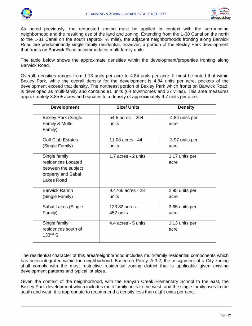
As noted previously, the requested zoning must be applied in context with the surrounding neighborhood and the resulting use of the land and zoning. Extending from the L-30 Canal on the north to the L-31 Canal on the south (approx. ½ mile), the adjacent neighborhoods fronting along Barwick Road are predominantly single family residential, however, a portion of the Bexley Park development that fronts on Barwick Road accommodates multi-family units. The table below shows the approximate densities within the development/properties fronting along Barwick Road. Overall, densities ranges from 1.13 units per acre to 4.84 units per acre. It must be noted that within Bexley Park, while the overall density for the development is 4.84 units per acre, pockets of the development exceed that density. The northeast portion of Bexley Park which fronts on Barwick Road, is developed as multi-family and contains 91 units (64 townhomes and 27 villas). This area measures approximately 8.85 ± acres and equates to a density of approximately 9.7 units per acre.
Development Size/ Units Density
Bexley Park (Single
Family & Multi-
Family)
54.5 acres – 264
units
4.84 units per
acre
Golf Club Estates
(Single Family)
11.08 acres - 44
units
3.97 units per
acre
Single family
residences Located
between the subject
property and Sabal
Lakes Road
1.7 acres - 2 units 1.17 units per
acre
Barwick Ranch
(Single Family)
9.4766 acres - 28
units
2.95 units per
acre
Sabal Lakes (Single
Family)
123.82 acres -
452 units
3.65 units per
acre
Single family
residences south of
133Rd S
4.4 acres - 5 units 1.13 units per
acre
The residential character of this area/neighborhood includes multi-family residential components which has been integrated within the neighborhood. Based on Policy A-3.2, the assignment of a City zoning shall comply with the most restrictive residential zoning district that is applicable given existing development patterns and typical lot sizes. Given the context of the neighborhood, with the Banyan Creek Elementary School to the east, the Bexley Park development which includes multi-family units to the west, and the single family uses to the south and west, it is appropriate to recommend a density less than eight units per acre.
PLANNING & ZONING BOARD STAFF REPORT
Page | 22
E) Remaining, isolated infill lots within the coastal planning area shall be developed under zoning which is identical or similar to the zoning of adjacent properties; and, the resulting development shall be of a design and intensity which is similar to the adjacent development. This Standard is not applicable.
REVIEW BY OTHERS The subject properties are not in an area that requires review by the Community Redevelopment Agency (CRA) or Downtown Development Authority (DDA). Palm Beach County Notice: On July 20, 2018, the Palm Beach County Planning Division was notified of the City’s intent to annex this property. No objection has been received from Palm Beach County to date. IPARC Notice: On August 22, 2018, notice of the Future Land Use Amendment has also been provided to the Interlocal Plan Amendment Review Committee (IPARC) which distributes the information to adjacent municipalities. No opposition has been noted. Notice to Adjacent Municipality On October 2, 2018, notice was provided to the City of Boynton Beach. Letter of support or objection, if any, will be presented at the Planning and Zoning Board meeting. Courtesy Notices: Special courtesy notices were provided to the following homeowners and civic associations:
Country Manor Sabal Lakes Barwick Ranch Estates Bexley Park Chatelaine Rainberry Bay Rainberry Woods Delray Shores
Public Notice: Formal public notice has been provided to the owner of the subject property as well as property owners within a 500' radius of the subject property. Letters of support or objection, if any, will be presented at the Planning and Zoning Board meeting. ASSESSMENT AND CONCLUSION Accommodating the annexation of this property is consistent with the City’s program for annexation of territory within its planning and utility service area. The FLUM request to MD is consistent with the existing advisory MD designation. However, based on Policy A-3.2, the assignment of a City zoning shall comply with the most restrictive residential zoning district that is applicable given existing development patterns and typical lot sizes. A recommendation of Medium Density Residential with a density suffix of six units per acre (RM-6) is more appropriate in maintaining the overall low density

PLANNING & ZONING BOARD STAFF REPORT
Page | 23
residential character of the neighborhood. The RM zoning district provides sufficient regulations to ensure that areas of incompatibility can be mitigated. Thus, positive findings can be made with respect to Concurrency and Compatibility with the surrounding land uses. The City will receive additional revenue from property taxes, in addition to storm water assessment fees utility taxes, franchise fees, and licensing fees upon development. The total immediate revenue increase is approximately $17,353.14 (ad valorem). Based upon the above, the proposed Annexation, Future Land Use Map Amendment and associated Rezoning application should be approved.
ALTERNATIVE ACTIONS
A. Continue with direction. B. Move a recommendation of approval to the City Commission for the Annexation, small scale
FLUM Amendment re-designating from Palm Beach County Medium Density Residential 5 units per acre (MR-5) to City Medium Density Residential 5-12 du/ac (MD); and re-designating the zoning district from Palm Beach County Agricultural Residential (AR) in part and Residential High (RH) in part and establishing a City zoning of Medium Density Residential six units per acre (RM-6) for the subject property, by adopting the findings of fact and law contained in the staff report, and finding that the request and approval thereof is consistent with F.S. 171.044 in that the property is contiguous to the City, reasonably compact and does not create an enclave; consistent with the Comprehensive Plan and meets the criteria set forth in Sections 2.4.5(D)(5), 3.1.1 and 3.2.2 of the Land Development Regulations.
C. Move a recommendation of denial to the City Commission for the Annexation, FLUM Amendment
re-designating from Palm Beach County Medium Density Residential 5 units per acre (MR-5) to City Medium Density Residential (MD), and re-designating the zoning district from Palm Beach County Agricultural Residential (AR) in part and Residential High (RH) in part and establishing a City zoning of Medium Density Residential, six units per acre (RM) for the subject property, by adopting the findings of fact and law contained in the staff report, and finding that the request is inconsistent with F.S. 171.044; inconsistent with the Comprehensive Plan, and does not meet the criteria set forth in Sections 2.4.5(D) (5), 3.1.1 and 3.2.2 of the Land Development Regulations.
Attachments: Attachments:
Aerial Location Map
Survey of Property
Applicant’s Justification Statement
City of Delray Beach Future Land Use Map
City of Delray Beach Zoning Map
City of Delray Beach Planning Area
Residential Neighborhood Categorization Map
Table L-6 Land Use designation/Zoning Matrix
PLANNING & ZONING BOARD STAFF REPORT
Page | 24
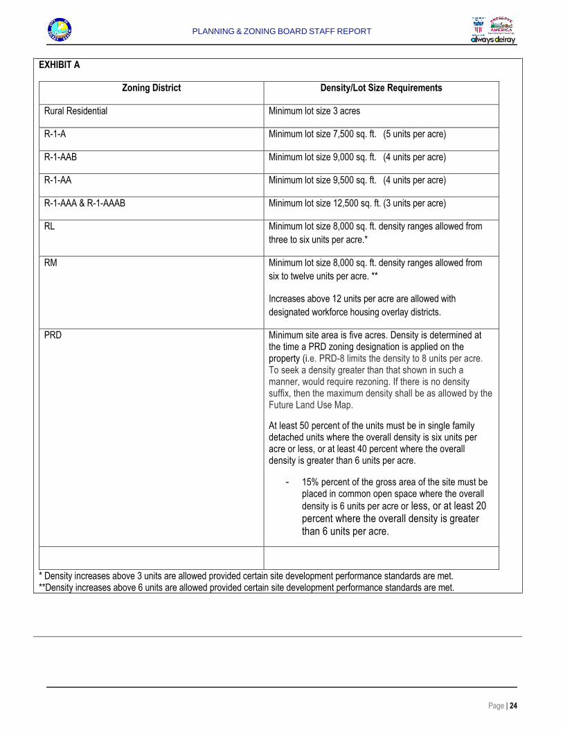
EXHIBIT A
Zoning District Density/Lot Size Requirements
Rural Residential Minimum lot size 3 acres
R-1-A Minimum lot size 7,500 sq. ft. (5 units per acre)
R-1-AAB Minimum lot size 9,000 sq. ft. (4 units per acre)
R-1-AA Minimum lot size 9,500 sq. ft. (4 units per acre)
R-1-AAA & R-1-AAAB Minimum lot size 12,500 sq. ft. (3 units per acre)
RL Minimum lot size 8,000 sq. ft. density ranges allowed from
three to six units per acre.*
RM Minimum lot size 8,000 sq. ft. density ranges allowed from
six to twelve units per acre. **
Increases above 12 units per acre are allowed with
designated workforce housing overlay districts.
PRD Minimum site area is five acres. Density is determined at the time a PRD zoning designation is applied on the property (i.e. PRD-8 limits the density to 8 units per acre. To seek a density greater than that shown in such a manner, would require rezoning. If there is no density suffix, then the maximum density shall be as allowed by the Future Land Use Map.
At least 50 percent of the units must be in single family detached units where the overall density is six units per acre or less, or at least 40 percent where the overall density is greater than 6 units per acre.
- 15% percent of the gross area of the site must be placed in common open space where the overall
density is 6 units per acre or less, or at least 20 percent where the overall density is greater than 6 units per acre.
* Density increases above 3 units are allowed provided certain site development performance standards are met. **Density increases above 6 units are allowed provided certain site development performance standards are met.
PLANNING & ZONING BOARD STAFF REPORT
Page | 25
EXHIBIT B City Commission Estimated Adoption Schedule
Annexation Ordinance
November 20, 2018 City Commission – 1st Reading
December 4, 2018 City Commission- 2nd Reading
Future Land Use Map (FLUM) Ordinance
January 15, 2019 City Commission 1st Reading
February 5, 2019 City Commission 2nd Reading
Rezoning Ordinance
February 5, 2019 City Commission 1st Reading
March 28, 2019 City Commission 2nd Reading
Banyan CreekElementary
School
BanyanCove
L-30 Canal L-30 Canal
Lake Ida Rd Lake Ida Rd
Barw
ick R
d
S Milit
ary T
rl
NW 6th Ct
NW 10th St
Rainberry Cir N
Sabal Lakes Rd
Fent
on D
r
Lone Pine Rd
Riviera Dr
Country Manors Blvd
W Be
xley P
ark D
r
NW 7th Ct
Satin Leaf Ct
Highgate Dr
Angler Dr
Rainberry Cir S
NW 15th St
133rd Rd S
E Lan
cewo
od Pl
Via Delray
NW 29
th Av
e
NW 37
th Av
e
Privet Pl
Sunfl
ower
Ave
Oak Hill Rd
NW 8th St
Petal Pl
Danson Way
NW 14th St
NW 9th St
Pine Tree Dr
Sunrise Blvd
Riverside Way
Woodland Dr
NW 26
th Av
e
Palm Ridge Blvd
W Ma
gnoli
a Cir
Modern Dr
Beechwood Rd
S Classical Blvd
NW 32
nd Av
e
Shad
y Ln
N Classical Blvd
Sea Grape Cir
N Magnolia Cir
NW 30
th Av
e
Avenue VillandryAvenue Montresor
Coral
Way
NW 12th St
48th Trl S
E Mag
nolia
Cir
S Lancewood Pl
Park Tree Pl
NW 26
th Ln
NW 31
st Av
eCortez Ct
Cardina
l Ln
Bluebird Ln
NW 27
th Av
e
NW 10th Pl
Beachwood Dr
NW 13th St
Meadowlark Ln
Lancewood PlRuth
Ln
Sand
piper
Cir
Bexle
y Par
k Dr
NW 39
th Av
e
E Wickham Cir
NW 43rd Ave
W Wi
ckha
m Ci
r
NW 30th Ave
NW 6th Ct
NW 32
nd Av
e
NW 9th St
Sunrise Blvd
NW 7th Ct
NW 10th St
Pine Tree Dr
Palm Ridge Blvd
Palm Beach County
0 750375Feet
Print Date: 10/3/2018
ICity of Delray Beach
Development Services
Banyan CoveGeneral Location
X
W
X
X
XXXXXXXXXXXXXXXXXXXXXXXXXXXXXXXXXXXXXXXXXXXXX
90.00' AT 90°
S01°09'33"E90.07'(C)
N89°
02'22
"W 2
96.7
0'(C)
N88
°10'2
5"W
296
.52'
(R)
S89°02'22"E40.03'(C)
90.08'(C)
11.6
4' L.
W.D
.D. E
ASEM
ENT
ORB
2662
4, P
AGE
1990
BEARING BASIS WEST LINE OF SECTION 12-46-42 S01°14'31"E 5295.07'(C&M) (GRID) 80.00' RIGHT-OF-WAYASPHALT ROAD
771.00' AT 90°(R)
521.00' AT 90°(R)
549.75' AT 90°(R)
N. L
INE
OF
THE
N.E
. 1/4
OF
SE
CTI
ON
12/
46S
/42E
POIN
T OF
COM
MEN
CEM
ENT
N.W
. CO
RN
ER
OF
THE
N.E
. 1/4
OF
SE
CTI
ON
12/
46S
/42E
, PA
LM B
EA
CH
CO
UN
TY,
FLO
RID
AFO
UND
NAIL
& D
ISK
LS45
15
40.00' LESSED FOR ROAD RIGHT-OF-WAY
90' L
ES
SE
D F
OR
L.W
.D.D
.LA
TER
AL
CA
NA
L L-
30 R
IGH
T-O
F-W
AY
(OR
B 2
351,
PA
GE
171
4)
S89°
02'22
"E 3
37.6
2'(C)
POINT OF BEGINNING SET5/8" IRON ROD & CAP LB8111
FOUN
D 5/
8" IR
ONRO
D &
CAP
LB 8
111
WPP
DOG
PEN
ON C
ONCR
ETE
CON
C
FOUN
D 1-
1/4"
IRON
PIP
E(1
1.9'S
,1.4
'E)
(W.C.=24.8'S)FOUND 5/8" IRON ROD& CAP LB3591
(TYPICAL)METAL FENCE
(W.C
.=52
1.3'N
)FO
UND
1/2"
IRON
ROD
SEPT
IC T
ANK
ONE
STOR
YRE
SIDE
NCE
4243 SABAL LAKES ROADPARCEL #: 12424612000001090
OWNER: SCHOOL BOARD OF PALM BEACH COUNTYWARRANTY DEED (O.R.B. 5253, PG. 1535) 20
1'N,
3'E201'N
,5'E
ASPH
ALT
DRIV
E
ASPHALT PATH
40.0
0'AT
90°
E. LINE OF THE W. 1/4 OF THEN.W. 1/4 OF THE N.E. 1/4 OF
SECTION 12/46S/42E
ONE
STOR
YRE
SIDE
NCE
#1
3038
XXX
BARW
ICK
ROAD
PAR
CEL
#: 0
0424
6120
0000
1050
OWNE
R: A
NDRE
W V
. POD
RAY
WAR
RANT
Y DE
ED(O
.R.B
. 253
64, P
G. 1
371)
S01°09'33"E 980.69'
N01°14'31"W 982.51'
BARWICK ROAD
WPP
WPPANCHOR
OHC
(TYP
)W
PPAN
CHOR
79.7'
84.8
'
84.7
'
81.2'
X
23.7
0'
19.40'
12.0
0'
20.60'
35.7
0'
40.00'PAD
PAD
WEL
L
1.2'
WPPANCHOR
WM
25.25
' 38.70'
17.45
'
18.45'
56.45
'
18.45' 13.75
'38.70'
CONC
CONC
PAD PA
D
CONC
129.
2'
122.
5'
630.1'
WPP
/ANC
HOR
#23
#22
#24
#25
#26
#27
#28
#33
#29
#30
#31
#32
#34
#35
#36
#27
#28
#29
#30
#31
#32
#33
#34
#35
#46
#37
#36
#38
#39
#40
#41
#42
#43#4
4#4
5#47
#48
#49
#50
#51
#52
#53
#54
#55
#56
#57
#58
#59
#60 #6
1
#62
#63
#64
#65
#66
#67
#71
#70
#69
#68
#72
#73
#74
#75
#76 #7
7
#78
#79
#80
#81
#82
#82
#86
#85
#84
#83#8
7#8
8#8
9
#90
#91
#92
#93
#94
#95
#96
#97
#98
#99
#100#1
01 #102
#103
#104
#105
#106
#107
#108 #1
09
#110
#111
#112 #1
13
#114
#115
#116 #117
#118
#119 #1
20 #121 #1
25#1
26 #128
#127
#129
#122
#124
#123
#131
#130
#132#1
33#1
34#1
35#1
36#1
37#138
#139
#140
#141
#142
#143
#144
#145#1
46#1
47#1
48
#150
#149#151
#152
#153
#157
#154
#156
#155
#157
#158
#159#1
60#1
61
#162
#163
#164
#165
#166
#167
#168
#169
#170
#171
#172
#176
#173
#174
#175
#177
#178
#179
#180
#181
#182
#183
#180
#184
#185#186
#187
#188
#189 #1
90
#191
#192
#193
#194
#196
#197
#198
#199
#195
#200
#201 #2
02
#203
#204
#207
#208 #2
05#209
#210
#206
#211
#212
#213
#214
#215
#216
#217
#218
#219
#220 #2
21
#222
#223
#224 #2
25#2
26
#228
#227
#229
#230
#231
#232
#233
#231
#231
#234
#235
#236
#237
#239
#238
#240
#241
#242
#243
#247
#248
#249
#250
#251
#252
#253
#244
#245
#246
#254
#255
#256
#257
#258
#259
#260
#261 (P
ARCE
L II
& III
)13
132
BARW
ICK
ROAD
PARC
EL I.
D. #
: 004
2461
2000
0010
20
(PAR
CEL
I)13
038
BARW
ICK
ROAD
PARC
EL I.
D.#:
004
2461
2000
0010
60
PALM
CLU
STER
XXX
GUARDRAIL
CATC
H BA
SIN
GRAT
E= 1
6.56
EDGE OF WATER
TOP
OF 4
8"CO
RRUG
ATED
PIPE
FLORIDA POWER AND LIGHT COMPANYEASEMENT (ORB 6922, PAGE 842)
DRIV
EWAY
HIGHGATEDRIVE
PINE TREEDRIVE
DRIV
EWAY
DRIV
EWAY
S00°00'00"W 521.26' (R)
40.0
0
WEST RIGHT-OF-WAY LINE
GOLF CLUB ESTATESPLAT BOOK 25, PAGE 235BEXLEY PARK
PLAT BOOK 102, PAGE 48
UNPLATTED
S89°
02'22
"E29
7.43
' (C&M
)
top
of b
ank±
80' RIGHT-OF-WAY PER DESCRIPTION ANDPLAT BOOK 102, PAGE 48, PLAT BOOK 25, PAGE 235
MAT
CH L
INE
1 inch = ft.
( IN FEET )
GRAPHIC SCALE030 30 60
30.0
12015
CITY OF DELRAY BEACH
CITY OF DELRAY BEACH
SABL
E LA
KES
DELR
AY
GARD
ENSCO
COA
PINE
ESTA
TES
CONT
RYM
ANOR
S
MILITARY TRAIL
BARWICK ROAD ATLA
NTIC
BOU
LEVA
RD
N CONGRESS AVE
I-95
LAKE
IDA
ROAD
CANA
L
SITE PM SURVEYING
BOUNDARY SURVEY
SIGNED:_________ _____________________ GINO FURLANO PROFESSIONAL LAND SURVEYOR AND MAPPER FLORIDA CERTIFICATE No. 5044
4546 CAMBRIDGE STREETWEST PALM BEACH, FL 33415OFFICE 561-478-7764FAX 561-478-1094
LICENSED BUSINESS No. 6788
Please visit us on the web @ www.pmsurveying.net
LOCATION MAP(NTS)
ABBREVIATIONSOHC OVERHEAD CABLEWPP WOOD POWER POLETYP TYPICAL(R) RECORD(C) CALCULATED(M) MEASUREDORB OFFICIAL RECORDS BOOKL.W.D.D. LAKE WORTH DRAINAGE DISTRICT
O
ETC
NO. 5044STATE OF
I D
U
LFRO
DN S
EF
OR
P
A
NOI
S
L
S
AL
RE
PP
M
O
AYEVR
R&
A
RCGINO FU
TR IFIE
LANA
PROPERTY ADDRESS:13038 AND 13132 BARWICK ROADDELRAY BEACH FLORIDA 33445
FLOOD ZONE: "X"Panel No: 12099C 0976FDate: OCTOBER 5, 2017
CERTIFIED TO:1. ANDREW V PODRAY
SHEET 1 OF 2
PM SURVEYING
LEGAL DESCRIPTION:PARCEL ITHE NORTH 549.75 FEET OF THE WEST ONE-QUARTER (W1/4) OF THE NORTHWEST ONE-QUARTER (NW 1/4) OF THE NORTHEAST ONE-QUARTER (NE 1/4) OF SECTION 12, TOWNSHIP 46SOUTH, RANGE 42 EAST, PALM BEACH COUNTY FLORIDA, LESS THE WEST 40.00 FEET OF ROAD RIGHT-OF-WAY RECORDED IN O.R. BOOK 52, PAGE 576, MORE PARTICULARLYDESCRIBED AS FOLLOWS: THE WEST 40 FEET OF THE NORTHWEST ONE-QUARTER (NW 1/4) OF THE NORTHEAST ONE-QUARTER (NE 1/4) OF SECTION 12, TOWNSHIP 46 SOUTH, RANGE42 EAST, LESS AND EXCEPT THE LAKE WORTH DRAINAGE DISTRICT CANAL L-30.PARCEL II AND IIITHE NORTH 521.00 FEET OF THE SOUTH 771.00 FEET OF THE WEST ONE-QUARTER (W-1/4) OF THE NORTHWEST ONE QUARTER (NW 14) OF THE NORTHEAST ONE-QUARTER (NE 14)OF SECTION 12, TOWNSHIP 46 SOUTH, RANGE 42 EAST, PALM BEACH COUNTY FLORIDA, LESS THE WEST 40.00 FEET FOR ROAD RIGHT-OF-WAY, MORE PARTICULARLYDESCRIBED AS FOLLOWS: COMMENCING AT THE SOUTHWEST CORNER OF THE NORTHWEST ONE QUARTER (NW 14) OF THE NORTHEAST ONE-QUARTER (NE 14) OF SECTION 12,TOWNSHIP 46 SOUTH, RANGE 42 EAST; THENCE RUN N00°00'00"E, ALONG THE WEST LINE OF SAID NORTHWEST ONE-QUARTER OF THE NORTHEAST ONE-QUARTER, ADISTANCE OF 250.13 FEET TO A POINT ON SAID WEST LINE, ALSO BEING THE CENTER LINE OF BARWICK ROAD, (80 FOOT RIGHT-OF-WAY); THENCE RUN S88°10'24"E A DISTANCEOF 40.00 FEET TO A POINT ON THE EAST RIGHT-OF-WAY LINE OF BARWICK ROAD AND THE POINT OF BEGINNING; THENCE CONTINUE ALONG THE LAST DESCRIBED COURSE, ADISTANCE OF 295.82 FEET TO A POINT ON THE EAST LINE OF THE WEST ONE-QUARTER (W 14) OF THE NORTHWEST ONE QUARTER (NW 14) OF THE NORTHEAST ONE-QUARTER(NE 14) OF SAID SECTION 12; THENCE RUN N00°04'35"E, ALONG SAID EAST LINE, A DISTANCE OF 521.24 FEET TO A POINT; THENCE RUN N88°10'25"W A DISTANCE OF 296.52 FEETTO A POINT ON THE EAST RIGHT-OF-WAY LINE OF BARWICK ROAD; THENCE RUN S00°00'00"W, ALONG SAID EAST RIGHT-OF-WAY LINE, A DISTANCE OF 521.26 FEET TO THEPOINT OF BEGINNING.
CONTAINING 290906.54 SQUARE FEET, OR 6.678 ACRES
BOUNDARY SURVEY
SIGNED:_________ _____________________ GINO FURLANO PROFESSIONAL LAND SURVEYOR AND MAPPER FLORIDA CERTIFICATE No. 5044
4546 CAMBRIDGE STREETWEST PALM BEACH, FL 33415OFFICE 561-478-7764FAX 561-478-1094
LICENSED BUSINESS No. 6788
Please visit us on the web @ www.pmsurveying.net
LOCATION MAP(NTS)
ABBREVIATIONSOHC OVERHEAD CABLEWPP WOOD POWER POLETYP TYPICAL(R) RECORD(C) CALCULATED(M) MEASUREDORB OFFICIAL RECORDS BOOKL.W.D.D. LAKE WORTH DRAINAGE DISTRICT
O
ETC
NO. 5044STATE OF
I D
U
LFRO
DN S
EF
OR
P
A
NOI
S
L
S
AL
RE
PP
M
O
AYEVR
R&
A
RCGINO FU
TR IFIE
LANA
PROPERTY ADDRESS:13038 AND 13132 BARWICK ROADDELRAY BEACH FLORIDA 33445
FLOOD ZONE: "X"Panel No: 12099C 0976FDate: OCTOBER 5, 2017
CERTIFIED TO:1. ANDREW V PODRAY
SHEET 1 OF 2
SURVEYORS' NOTES:
1. I HEREBY CERTIFY THIS SURVEY MEETS STANDARDS OF PRACTICE PURSUANT TO FLORIDA STATUTES.2. THE SURVEY MAP AND REPORT AND THE COPIES THEREOF ARE NOT VALID WITHOUT THE SIGNATURE AND THE ORIGINALRAISED SEAL OF A FLORIDA LICENSED SURVEYOR AND MAPPER.3. UNDERGROUND OR OBSCURED IMPROVEMENTS WERE NOT LOCATED.4. DIMENSIONS ARE RECORD AND FIELD UNLESS OTHERWISE NOTED.5. STATED DIMENSIONS TAKE PRECEDENCE OVER SCALED DIMENSIONS.6. THIS FIRM'S CERTIFICATE OF AUTHORIZATION NUMBER IS LB 6788.7. ADDITIONS OR DELETIONS TO SURVEY MAPS OR REPORTS BY OTHER THAN THE SIGNING PARTY OR PARTIES IS PROHIBITEDWITHOUT WRITTEN CONSENT OF THE SIGNING PARTY OR PARTIES.8. SURVEY SUBJECT TO RESERVATIONS, RESTRICTIONS, EASEMENTS AND RIGHTS-OF-WAY OF RECORD. (SEE TITLE REVIEW).9. LOCATION MAP IS GLEANED FROM ONLINE MAPPING SITES AND AND IS ONLY APPROXIMATE.10. ELEVATIONS SHOWN HEREON ARE BASED ON NORTH AMERICAN VERTICAL DATUM OF 1988. (NAVD'88)
ALL DISTANCES SHOWN HEREON ARE GRID UNLESS NOTED OTHERWISE.COORDINATES SHOWN HEREON ARE GRIDDATUM= NAD 83, 1990 ADJUSTMENTZONE= FLORIDA EASTLINEAR UNITS= U.S. SURVEY FOOTCOORDINATE SYSTEM= 1983 STATE PLANE TRANSVERSE MERCATOR PROJECTION.PROJECT SCALE FACTOR=1.000037366GRID DISTANCE / SCALE FACTOR= GROUND DISTANCE
7-27-18 ADDITIONAL COMMENTS JH
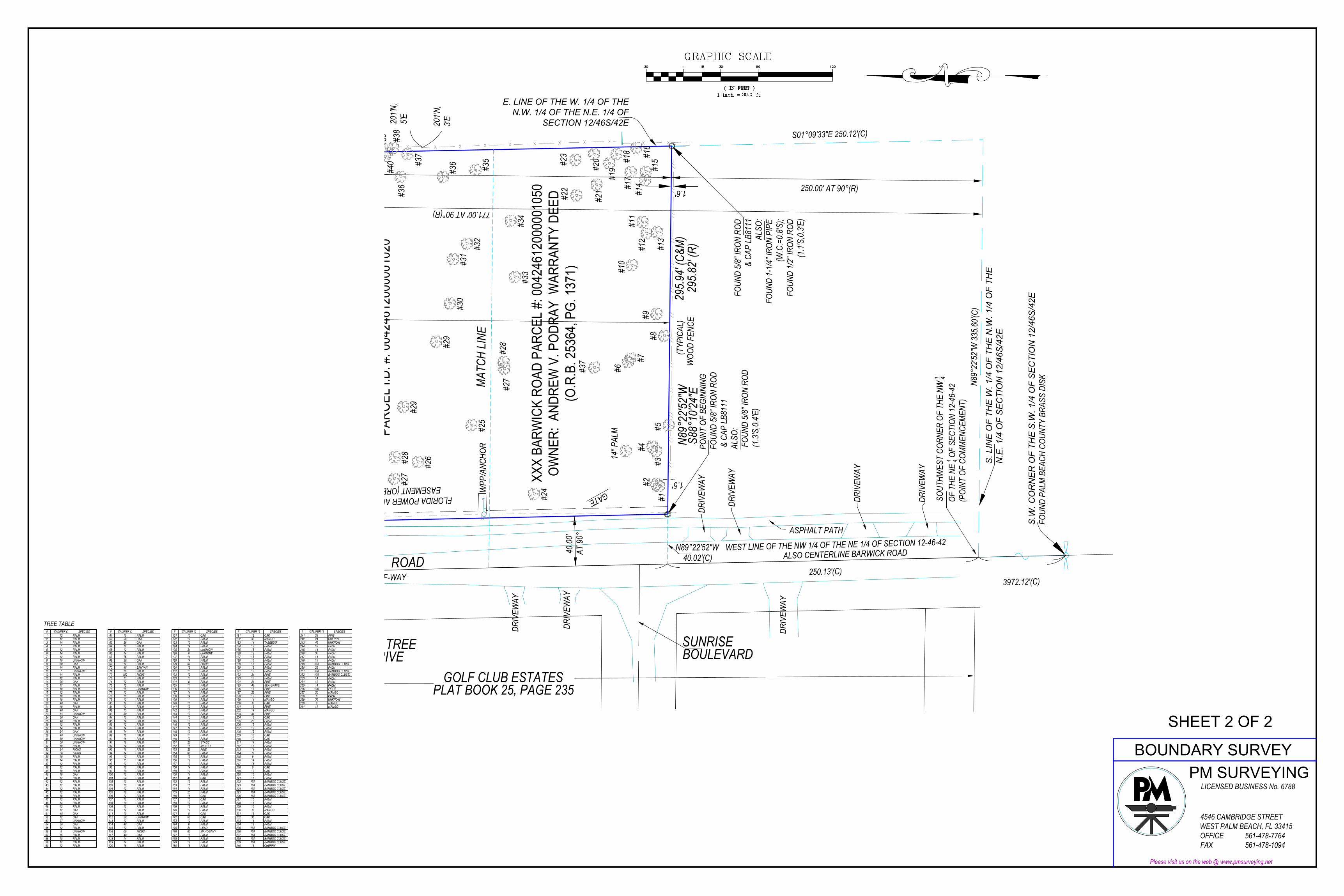
#1
CALIPER (') SPECIES12 PALM
2 12 PALM3 14 PALM4 7 PALM5 12 PALM6 14 PALM7 12 PALM8 10 UNKNOW9 60 OAK
10 14 PALM11 7 UNKNOW12 14 PALM13 12 PALM14 OAK15 PALM16 10 PALM17 12 PALM18 10 PALM19 10 PALM20 48 OAK21 10 PALM22 48 OAK
3617
23 14 UNKNOW24 36 OAK25 48 PALM26 12 PALM27 14 PALM28 OAK29 40 UNKNOW30 50 UNKNOW31 50 UNKNOW32 10 PALM33 24 FICUS34 36 FICUS35 PALM36 PALM37 12 PALM38 12 PALM39 10 PALM40 10 OAK41 12 PALM42 12 PALM
1014
24
43 12 PALM44 12 PALM45 12 PALM46 18 PALM47 12 PALM48 14 PALM49 12 PALM50 12 OAK51 48 OAK52 12 OAK53 UNKNOW54 OAK55 12 PALM56 8 UNKNOW57 15 PALM58 15 PALM59 12 PALM
2736
#181
CALIPER (') SPECIES12 OAK
182 30 MANGO183 14 TABEBUIA184 12 PALM185 15 PALM186 12 PALM187 15 PALM188 15 PALM189 15 PALM190 15 PALM191 13 PALM192 24 PINE193 10 PALM194 PINE195 SEA GRAPE196 16 PINE197 22 PINE198 12 PINE199 14 MANGO200 8 OAK201 16 PINE202 14 MANGO
2148
203 34 PINE204 16 OAK205 20 PALM206 15 PALM207 12 PALM208 PALM209 18 OAK210 10 OAK211 14 PALM212 16 PALM213 14 PALM214 9 PALM215 PALM216 PALM217 18 PALM218 6 OAK219 12 OAK220 15 PALM221 15 PALM222 N/A BAMBOO CLUST.223 N/A
914
12
224225226227 15 PALM228 18 PALM229 15 PALM230 9 MANGO231 16 OAK232 36 OAK233 14 PALM234 PALM235236237238239240 16 CHERRY
12
N/AN/AN/A
N/A BAMBOO CLUST.N/AN/AN/AN/A
61 15 PALM62 36 OAK63 26 OAK64 12 PALM65 12 PALM66 14 PALM67 PALM68 28 OAK69 14 PALM70 48 BANYAN71 16 PALM
150 FICUS13 PALM
PALMPALM
15 UNKNOW77 13 PALM78 10 PALM79 12 PALM80 12 PALM81 12 PALM82 13 PALM
1212
16
7273747576
83 30 PALM84 15 PALM85 14 PALM86 12 PALM87 14 PALM88 PALM89 16 PALM90 16 PALM91 16 PALM92 14 PALM93 16 PALM94 PALM95 PALM96 PALM97 12 PALM98 12 PALM99 10 PALM
100 12 PALM101 24 PALM102 10 PALM103 10 PALM
1215
14
104 12 PALM105 12 PALM106 12 PALM107 12 PALM108 10 PALM109 12 PALM110 PALM111 10 PALM112 28 UNKNOW113 12 PALM114 OAK115 PALM116 60 FICUS117 48 OAK118 14 PALM119 14 PALM120 16 PALM
121 10 OAK122 12 PALM
4812
123 10 PALM124 14 PALM125 24 UNKMOW126 8 UNKNOW127 14 PALM128 PALM129 84 FICUS130 15 PALM131 13 PALM132 13 PALM
13 PALM8 PALM
PALMPALM
14 PALM138 14 PALM139 1 PALM140 16 PALM
10
14
133
136137
14
12
134135 10
141 13 PALM142 10 PALM143 10 PALM144 10 PALM145 10 PALM146 12 PALM147 9 PALM148 12 PALM149150 PALM151 20 STAGE152 18 MANGO153 28 PINE154 PALM
PALM12 PALM
157 12 PALM158 14 PALM159 12 PALM160 14 PALM161 48 OAK162 12 PALM
6013
163 16 PALM164 14 PALM165 25 PALM166 16 OAK167 16 OAK168 PALM169 12 PALM170 12 PALM171 8 OAK172 60 OAK
12 PALM8 PALM
LEADMAHOGANY
18 PALM178 16 PALM179 12 PALM180 16 PALM
60
12
176177
10
174175 24
13 PALM
155156
173
# CALIPER (') SPECIES
60 12 PALM
# CALIPER (') SPECIES
BAMBOO CLUST.BAMBOO CLUST.BAMBOO CLUST.BAMBOO CLUST.
BAMBOO CLUST.BAMBOO CLUST.BAMBOO CLUST.BAMBOO CLUST.
# CALIPER (') SPECIES241 28 PINE242 24 CHERRY243 49 UNKNOW244 10 PALM245 14 PALM246 30 PALM247 14 PALM248 PALM249 N/A BAMBOO CLUST.250 25
12
PALM
252
254255 14 PALM256 120257 20258 8 PALM259 UNKNOW260261 12
36
MANGO
251
25312 PALM
PALMFICUSMANGOPALM
9 MANGO
N/A BAMBOO CLUST.N/A BAMBOO CLUST.14 PALM
TREE TABLE
//
//
//
//
//
//
//
//
//
//
//
//
//
X X
XXXXXXXXXXXXXXXXXXXXXXX
250.00' AT 90°(R)
S01°09'33"E 250.12'(C)
N89°22'52"W40.02'(C)
250.13'(C)3972.12'(C)80.00' RIGHT-OF-WAY
771.00' AT 90°(R)
S.W
. CO
RN
ER
OF
THE
S.W
. 1/4
OF
SE
CTI
ON
12/
46S
/42E
FOUN
D PA
LM B
EACH
COU
NTY
BRAS
S DI
SK
40.0
0'AT
90°
N89°
22'52
"W 3
35.6
0'(C)
FOUN
D 5/
8" IR
ON R
OD &
CAP
LB8
111
ALSO
: F
OUND
1-1
/4" I
RON
PIPE
(W.C
.=0.
8'S);
FOU
ND 1
/2" I
RON
ROD
(1.1
'S,0
.3'E
)
(T
YPIC
AL)
WOO
D FE
NCE
(TYPICAL)METAL FENCE
201'N
,3'E20
1'N,
5'E
S. L
INE
OF
THE
W. 1
/4 O
F TH
E N
.W. 1
/4 O
F TH
EN
.E. 1
/4 O
F S
EC
TIO
N 1
2/46
S/4
2E
E. LINE OF THE W. 1/4 OF THEN.W. 1/4 OF THE N.E. 1/4 OF
SECTION 12/46S/42E
XXX
BARW
ICK
ROAD
PAR
CEL
#: 0
0424
6120
0000
1050
OWNE
R: A
NDRE
W V
. POD
RAY
WAR
RANT
Y DE
ED(O
.R.B
. 253
64, P
G. 1
371)
N89°
22'52
"W29
5.94
' (C&M
)
1.5'
1.6'
BARWICK ROAD
WPP
/ANC
HOR PO
INT
OF B
EGIN
NING
FOUN
D 5/
8" IR
ON R
OD &
CAP
LB8
111
ALSO
: F
OUND
5/8
" IRO
N RO
D (1
.3'S
,0.4
'E)
#1
#2#3
#4
#5#8
#9
#6
#7
#10
#12
#13
#11
#14
#15
#17
#16
#18
#19#2
0#2
1
#23
#22
#37
#24
#25
#26
#27
#28
#33
#29
#30
#31
#32
#34
#35
#36
#27
#28
#29
#37
#36
#38
#39
#40
1 inch = ft.
( IN FEET )
GRAPHIC SCALE030 30 60
30.0
12015
(PAR
CEL
II &
III)
1313
2 BA
RWIC
K RO
ADPA
RCEL
I.D.
#: 0
0424
6120
0000
1020
GATE
14" P
ALM
FLORIDA POWER AND LIGHT COMPANYEASEMENT (ORB 6922, PAGE 842)
PINE TREEDRIVE
SUNRISEBOULEVARD
DRIV
EWAY
DRIV
EWAY
DRIV
EWAY
DRIV
EWAY
DRIV
EWAY
DRIV
EWAY
DRIV
EWAY
ASPHALT PATH
SOUT
HWES
T CO
RNER
OF
THE
NW 1 4
OF T
HE N
E 1 4 O
F SE
CTIO
N 12
-46-
42(P
OINT
OF
COM
MEN
CEM
ENT)
WEST LINE OF THE NW 1/4 OF THE NE 1/4 OF SECTION 12-46-42ALSO CENTERLINE BARWICK ROAD
S88°
10'24
"E29
5.82
' (R)
GOLF CLUB ESTATESPLAT BOOK 25, PAGE 235
MAT
CH L
INE
PM SURVEYINGBOUNDARY SURVEY
4546 CAMBRIDGE STREETWEST PALM BEACH, FL 33415OFFICE 561-478-7764FAX 561-478-1094
LICENSED BUSINESS No. 6788
Please visit us on the web @ www.pmsurveying.net
SHEET 2 OF 2
Banyan Cove City of Delray Beach
Application for Annexation, Future Land Use and Initial Zoning
Justification Statement Original: July 13, 2018
APPLICATION REQUEST
On behalf of the property owner and applicant, Andrew Podray, Miller Land Planning, is pleased to propose this application for voluntary annexation of a 6.68 acre property located on the east side of Barwick Road approximately 250 feet north of Sabal Lakes Road. The property is currently in an enclave area under the jurisdiction of Palm Beach County however identified and planned for annexation into the City of Delray Beach. Along with the annexation, the application also requests that the City apply the future land use designation of Medium Density (MD) Residential as currently shown on the City’s Future Land Use Map and corresponding Medium Residential (RM) zoning district. Prior to this request, applications were filed with Palm Beach County to request a land use amendment to allow 8 units per acre. Palm Beach County has issued staff reports in support of the density at 8 units per acre. Likewise, discussions with the Delray Beach City Manager, City Attorney and City Planning & Zoning Director relative to annexation have been based on a density of 8 units per acre. Accordingly, this application requests the annexation, land use amendment to MD at 8 units per acre and corresponding zoning of RM. Approval of this application will allow for a future site plan application and development of multiple family residential or related development allowed by the RM zoning district.
PROJECT SUMMARY
Property Owner: Andrew V. Podray
Applicant: Andrew V. Podray
Agent: Miller Land Planning, Inc.
Project Manager: Ailish Villalobos / Bradley Miller, AICP
Site Location: East side of Barwick Road approximately 250 feet north of Sabal Lakes Road.
Property Control No’s: 00-42-46-12-00-000-1020/1050/1060
Existing Land Use: MR-5 (Palm Beach County)
Proposed Land Use: MD (City of Delray Beach) with density at 8 units per acre
Existing Zoning: AR/RH (Palm Beach County)
MILLER
LAND
PLANNING, INC.
508 E. Boynton Beach Boulevard
Boynton Beach, FL 33435
Phone ■ (561)736-8838
Fax ■ (561)736-8079
Email ■ millerlandplanning.com
Banyan Cove City of Delray Beach - Annexation, Land Use, Zoning Justification Statement - July 13, 2018
Page 2
Proposed Zoning: RM (City of Delray Beach) Site Area: 6.68 acres
BACKGROUND
This site is located within an enclave area that is under the jurisdiction of Palm Beach County, but planned and intended for annexation into the City of Delray Beach. The City serves this area with emergency services as well as water and sewer service. The City is also responsible for the maintenance of Barwick Road in this area. In 2016, the City and County collaborated on a proposed Interlocal Service Boundary Agreement (ISBA) to annex the properties within the enclave but after months of presentations, discussion and public hearings with the affected property owners, the City Council decided to stop the ISBA process.
In 2018, MLP on behalf of the applicant, has filed applications for a land use amendment and rezoning of the property through Palm Beach County for residential density of 8 units per acre which would allow for 53 units of multi family residential development. Through that process, discussions continued with the City of Delray Beach about the procedures for future annexation of the property into the City. Through the involvement of the City Manager, City Attorney and City Planning & Zoning Director, it has been determined that the Florida Statutes allows for the voluntary annexation of this property and reduces the enclave area remaining in Palm Beach County. Based on that determination, this application requests concurrent approval of voluntary annexation from Palm Beach County to the City of Delray Beach, implementation of the land use designation from Medium Residential 5 u/a (MR-5 Palm Beach County) to Medium Density (MD) Residential 5 – 12 u/a (City) and initial zoning from AR and RH (Palm Beach County) to Medium Density Residential (RM – City). No formal site plan application is being submitted at this time but acknowledged that a formal Site Plan application will be required for the proposed development prior to issuance of development permits.
APPLICATION DESCRIPTION
Miller Land Planning, agent for the applicant, is requesting the subject 6.68 acre property be voluntarily annexed into the City of Delray Beach from Palm Beach County, the designation of MD land use be implemented and the initial corresponding zoning of RM be approved.
The subject property is presently improved with a single family home and accessory structures that according to the property appraiser were built in 1959. The surrounding area has changed significantly since 1959 with the development of the Banyan Creek Elementary School in 1988 to the east, Sabal Lakes in the early 2000’s to the east and southeast, Bexley Park to the west around 2005 and the Hunter’s Run to the northeast in the City of Boynton Beach in the 1980’s. Likewise, most of the existing homes within Gulf Club Estates on the west side of Barwick Road and the two homes south of the subject property were constructed in the late 1970’s or early 1980’s. With that development, the City of Delray Beach has expanded its boundaries around this site by annexing the school property and Sabal Lakes community to the east and the Bexley Park development and other properties on the west side of Barwick Road. The Gulf Club Estates area on the west side of Barwick Road, one parcel on the west side of Barwick Road at the canal and two parcels immediately south of the subject property remain in the unincorporated area of Palm Beach County, however they too are designated to ultimately be
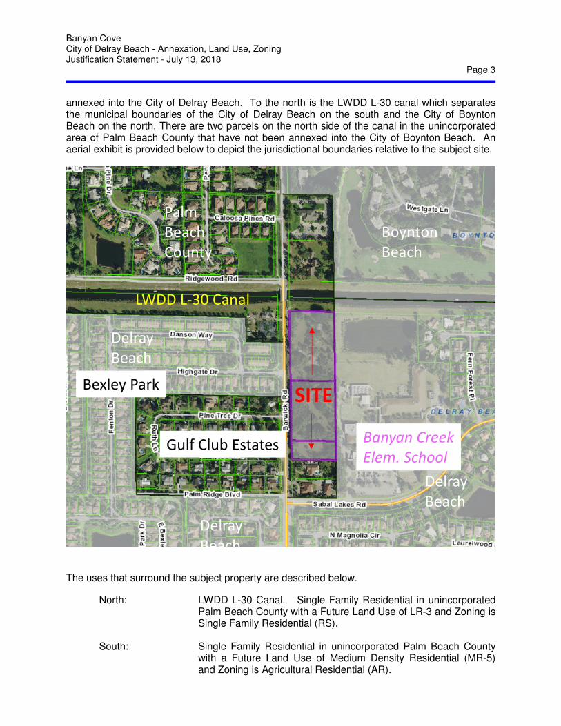
Banyan Cove City of Delray Beach - Annexation, Land Use, Zoning Justification Statement - July 13, 2018
Page 3
annexed into the City of Delray Beach. To the north is the LWDD L-30 canal which separates the municipal boundaries of the City of Delray Beach on the south and the City of Boynton Beach on the north. There are two parcels on the north side of the canal in the unincorporated area of Palm Beach County that have not been annexed into the City of Boynton Beach. An aerial exhibit is provided below to depict the jurisdictional boundaries relative to the subject site.
ANNEXATION – APPLICATION JUSTIFICATION
The uses that surround the subject property are described below.
North: LWDD L-30 Canal. Single Family Residential in unincorporated Palm Beach County with a Future Land Use of LR-3 and Zoning is Single Family Residential (RS).
South: Single Family Residential in unincorporated Palm Beach County
with a Future Land Use of Medium Density Residential (MR-5) and Zoning is Agricultural Residential (AR).
Boynton
Beach
Delray
Beach
Delray
Beach
Delray
Beach
Palm
Beach
County
LWDD L-30 Canal
Gulf Club Estates
Bexley Park
Banyan Creek
Elem. School
SITE
Banyan Cove City of Delray Beach - Annexation, Land Use, Zoning Justification Statement - July 13, 2018
Page 4
East: Banyan Creek Elementary School in City of Delray Beach with
Future Land Use of Institutional and Zoning is Community Facilities (CF).
West: Bexley Park Community with Triplex, Townhomes, and Zero Lot
Line homes in the City of Delray Beach with a Future Land Use of Low Density Residential (LD) and Zoning is Planned Residential Development (PRD).
Golf Club Estates with Single Family Residential homes in
unincorporated Palm Beach County with Future Land Use of Medium Density Residential (MR-5) and Zoning is Agricultural Residential (AR).
Furthermore, the proposed annexation, land use and zoning will be consistent with the surrounding area. Sabal Lakes and Gulf Club Estates are single family home communities where Bexley Park is a planned residential community which includes a mix of housing types including single family zero lot line homes, townhouses and triplex homes. The residential density is dispersed across the entire community with the lower density development being in the southern and western areas and the higher density development being in the northeastern area which is closest to the subject property. Overall the Bexley Park community complies with the Low Density (0-5 u/a) designation of the Future Land Use, however the higher density development in the northern area of the community from Barwick Road west to Fenton Drive contains triplex and townhome units that are developed at approximately 9 units per acre for that area. The Banyan Creek Elementary School is also a factor for both the future development of the subject site as well as the existing traffic conditions on Barwick Road. The active play area of the school abuts the majority of the subject property’s east boundary creating a compatibility concern, especially for single family homes. Likewise, the current traffic conditions at the peak hour times of the school, both morning and afternoon, create stacking and turning movement issues along Barwick Road and more particularly at the intersection with Sabal Lakes Road which is the only road to access the school. Although, the County has reviewed and approved a traffic study for the proposed applications for the subject site, the traffic concerns of the surrounding residents during the peak times of school traffic are real and need to be addressed by the School District, County and City. Given these existing conditions, the owner/applicant over the past several years has had significant developer interest in developing the site for multi-family residential housing. Under the current jurisdiction, the regulatory process of Palm Beach County, added with the process of the City of Delray Beach to secure water and sewer service, the interest has never come to action into actual development. Annexation of the property along with the implementation of the MD land use and RM zoning within the City will establish the basis and reduce the regulatory process to a Site Plan application and the necessary permits for the specific development plan.
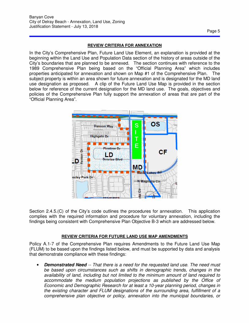
Banyan Cove City of Delray Beach - Annexation, Land Use, Zoning Justification Statement - July 13, 2018
Page 5
REVIEW CRITERIA FOR ANNEXATION
In the City’s Comprehensive Plan, Future Land Use Element, an explanation is provided at the beginning within the Land Use and Population Data section of the history of areas outside of the City’s boundaries that are planned to be annexed. The section continues with reference to the 1989 Comprehensive Plan being based on the “Official Planning Area” which includes properties anticipated for annexation and shown on Map #1 of the Comprehensive Plan. The subject property is within an area shown for future annexation and is designated for the MD land use designation as proposed. A clip of the Future Land Use Map is provided in the section below for reference of the current designation for the MD land use. The goals, objectives and policies of the Comprehensive Plan fully support the annexation of areas that are part of the “Official Planning Area”.
Section 2.4.5.(C) of the City’s code outlines the procedures for annexation. This application complies with the required information and procedure for voluntary annexation, including the findings being consistent with Comprehensive Plan Objective B-3 which are addressed below.
REVIEW CRITERIA FOR FUTURE LAND USE MAP AMENDMENTS
Policy A.1-7 of the Comprehensive Plan requires Amendments to the Future Land Use Map (FLUM) to be based upon the findings listed below, and must be supported by data and analysis that demonstrate compliance with these findings:
• Demonstrated Need -- That there is a need for the requested land use. The need must be based upon circumstances such as shifts in demographic trends, changes in the availability of land, including but not limited to the minimum amount of land required to accommodate the medium population projections as published by the Office of Economic and Demographic Research for at least a 10-year planning period, changes in the existing character and FLUM designations of the surrounding area, fulfillment of a comprehensive plan objective or policy, annexation into the municipal boundaries, or

Banyan Cove City of Delray Beach - Annexation, Land Use, Zoning Justification Statement - July 13, 2018
Page 6
similar circumstances. The need must be supported by data and analysis verifying the changing demographics or other circumstances. This requirement shall not apply to requests for the FLUM designations of Conservation or Recreation and Open Space; nor shall it apply to FLUM changes associated with annexations when the City’s advisory FLUM designation is being applied, or when the requested designation is of a similar intensity to the advisory designation. However, the findings described in the remainder of this policy must be addressed with all FLUM amendments.
Response: As indicated directly within the policy (and highlighted above in bold for emphasis), this requirement does not apply to applications associated with annexations when applying the City’s advisory FLUM designation. As shown in the graphic above, the Future Land Use Map shows this site with a planned MD land use designation which is also being requested with the annexation. Accordingly this requirement is not applicable.
• Consistency -- The requested designation is consistent with goals, objectives, and policies of the most recently adopted Comprehensive Plan.
Response: Objective B-3 of the Comprehensive Plan addresses annexation of properties. Policy B-3.1 and B-3.2 confirm that services such as fire protection, code enforcement and water and sewer facilities shall be provided to those properties anticipated for annexation. Policy B-3.3 and B-3.4 state that the FLUM designation as shown on the City’s Future Land Use Map “shall be in effect immediately upon annexation of a specific parcel”. For the subject site, as shown above, the Future Land Use designates this site with the MD land use designation. Accordingly, this application is consistent with the policy and should be immediately effective upon approval of the annexation.
• Concurrency -- Development at the highest intensity possible under the requested designation can meet the adopted concurrency standards.
Response: The subject property was previously subject to land use and zoning applications through Palm Beach County, therefore, concurrency services for proposed development that exceeded the highest intensity possible was evaluated and found to be sufficient for traffic capacity and school capacity. Correspondence confirming these determinations is provided as an attachment to this application. That application was later modified to allow a lesser development program however was not required to re-evaluate the traffic or school impacts since they were sufficient at a greater amount of intensity. Water and sewer service is available to the property through the City of Delray Beach, also documented and attached. With the annexation of the property into the City, there is no requirement for a water and sewer service agreement otherwise required if the property remains in the County. The water and sewer requirements for the specific development will be evaluated and confirmed at time of a Site Plan application. Likewise, fire and police services are available to the property and will also be confirmed at time of Site Plan application. Adequate services are available to serve the subject site as proposed.
Banyan Cove City of Delray Beach - Annexation, Land Use, Zoning Justification Statement - July 13, 2018
Page 7
• Compatibility -- The requested designation will be compatible with existing and future land uses of the surrounding area.
Response: The compatibility of surrounding uses is described in detail above within this statement. The proposed future land use is consistent with the Comprehensive Plan and therefore already determined to be compatible with the existing and future land uses of the area.
• Compliance -- Development under the requested designation will comply with the provisions and requirements of the Land Development Regulations.
Response: Following approval of the annexation and implementation of the future land use and zoning, a Site Plan application will be required to be processed through the City for the specific proposed development. The proposed development will be required to comply with all applicable provisions and requirements of the Land Development Regulations and the Site Plan application process will confirm compliance.
REVIEW CRITERIA FOR INITIAL ZONING
Section 2.4.5. (C)(3) and Section 4.2.3. of the City’s Code indicate that an application for voluntary annexation must be considered with an application for an initial zoning designation. This application proposes a voluntary annexation, consistent with the Comprehensive Plan, implementation of the MD land use designation as shown on the City’s Future Land Use Map and proposes the initial zoning designation of RM - Multiple Family Residential (Medium Density) which corresponds with the MD land use designation.
A change of zoning district designation must comply with Section 2.4.5(D) of the City’s Code and requires a statement of the reasons for the change. The section lists three “valid reasons” for approving the change and that the City Commission must find that the rezoning fulfills at least one of the “valid reasons”. This application fulfills the last two reasons (B & C) in that there is a change of circumstance that makes the current zoning inappropriate and that the requested zoning is similar in intensity as allowed under the Future Land Use Map and that it is more appropriate for the property based upon circumstances particular to the site and or neighborhood. The change in circumstance is based on the annexation of the property from Palm Beach County to the City of Delray Beach. The County zoning for this property is part Agricultural Residential (AR) and the balance Residential High (RH). With the annexation, an initial zoning designation needs to be applied to the property consistent with the Future Land Use Map designation of MD which allows residential density from 5 to 12 units per acre. The proposed 8 units per acre is consistent with the MD land use did RM zoning. The initial zoning proposed by this application is RM, Multiple Family Residential (Medium Density) which allows residential density from 6 to 12 units per acre. The RM district is consistent with the MD land use and the requirement for annexation as indicated in Section 2.4.5.(D). The proposed 8 units per acre is consistent with the MD land use did RM zoning. The proposed 8 units per acre is consistent with the MD land use did RM zoning.
Banyan Cove City of Delray Beach - Annexation, Land Use, Zoning Justification Statement - July 13, 2018
Page 8
CONCLUSION
As indicated in the Comprehensive Plan, this property along with others in the City are planned for and intended to be annexed into the City of Delray Beach. This application will reduce an existing enclave of area currently under jurisdiction of Palm Beach County by voluntary annexation into the City of Delray Beach. In conjunction with the annexation, the planned designation of MD land use and corresponding zoning of RM will be applied to the property which will allow the property to be developed appropriately and consistently with the surrounding area. The application is consistent with the rules and procedures for voluntary annexation, is consistent with the designation for land use complies with the findings for approval by the City Commission. The project manager for this application at Miller Land Planning is Ailish Villalobos. Should any additional information be required, she can be contacted at the number above or via email at [email protected].
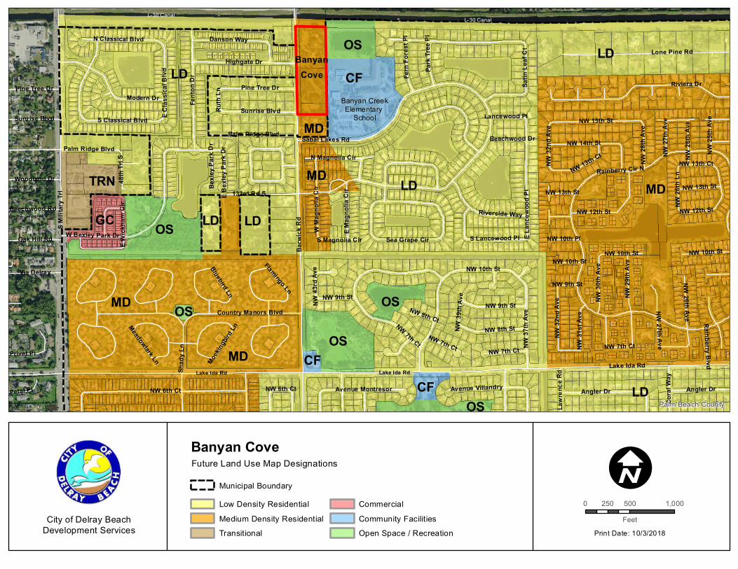
LD LD
Banyan CreekElementary
School
BanyanCove
Lake Ida RdLake Ida Rd
L-30 CanalL-30 Canal
OS
OSMD
MD CFOS
OS
OS
OS
GC
TRN
LD
LD
LD
MD
LD
MD
CF
CF
MD
Lake Ida Rd
Barw
ick R
d
S Milit
ary T
rl
NW 6th Ct
Rainberry Cir N
NW 10th St
Lone Pine Rd
Sabal Lakes Rd
Fent
on D
r
Country Manors Blvd
W Bexley Park Dr
NW 7th Ct
Satin
Leaf
Ct
Angler Dr
Highgate Dr
NW 15th St
133rd Rd S
E Lan
cewo
od P
l
NW 29
th Av
e
NW 37
th Av
e
NW 8th St
NW 9th St
Danson Way
NW 14th St
Pine Tree Dr
Sunrise Blvd
Riverside Way
NW 26th Ave
Palm Ridge Blvd
Via Delray
W Ma
gnoli
a Cir
Modern DrRiviera Dr
Shad
y Ln
NW 32
nd Av
e
S Classical Blvd
NW 13th Ct
Sea Grape Cir
N Classical Blvd
Oak Hill Rd
Privet Pl
E Clas
sical
Blvd
NW 30
th Av
e
N Magnolia Cir
Avenue Villandry
Cora
l Way
Avenue Montresor
NW 12th St
48th
Trl S
NW 25
th Av
e
Petal Pl
Woodland Dr
E Mag
nolia
Cir NW 13th St
Park
Tree
Pl
S Lancewood Pl
Fern
Fore
st Pl
NW 26
th Ln
NW 31
st Av
e
NW 28
th Av
e
Beechwood Rd
Lawr
ence
Rd
E Bex
ley P
ark D
r
Bluebird Ln
NW 10th Pl
NW 27
th Av
e
S Magnolia Cir
Flamingo Ln
Beachwood Dr
Ruth
Ln
Rainberry Blvd
Meadowlark Ln Mockin
gbird
Ln
Lancewood Pl
NW 8th Ct
Bexle
y Par
k Dr
NW 39
th Av
e
E Wick
ham
Cir
NW 43
rd Av
e
NW 13th St
Pine Tree DrNW
27th AveNW 7th Ct
NW 12th St
NW 10th StNW 10th St
Angler Dr
NW 13th Ct
NW 9th St
Palm Ridge Blvd
NW 6th Ct
NW 26
th Av
e
NW 7th CtNW 7th Ct
Sunrise Blvd
NW 9th St
NW 10th St
NW 32
nd Av
e
Palm Beach County
0 500 1,000250Feet
Print Date: 10/3/2018
ICity of Delray Beach
Development Services
Banyan Cove
Low Density ResidentialMedium Density ResidentialTransitional
CommercialCommunity FacilitiesOpen Space / Recreation
Future Land Use Map Designations
Municipal Boundary
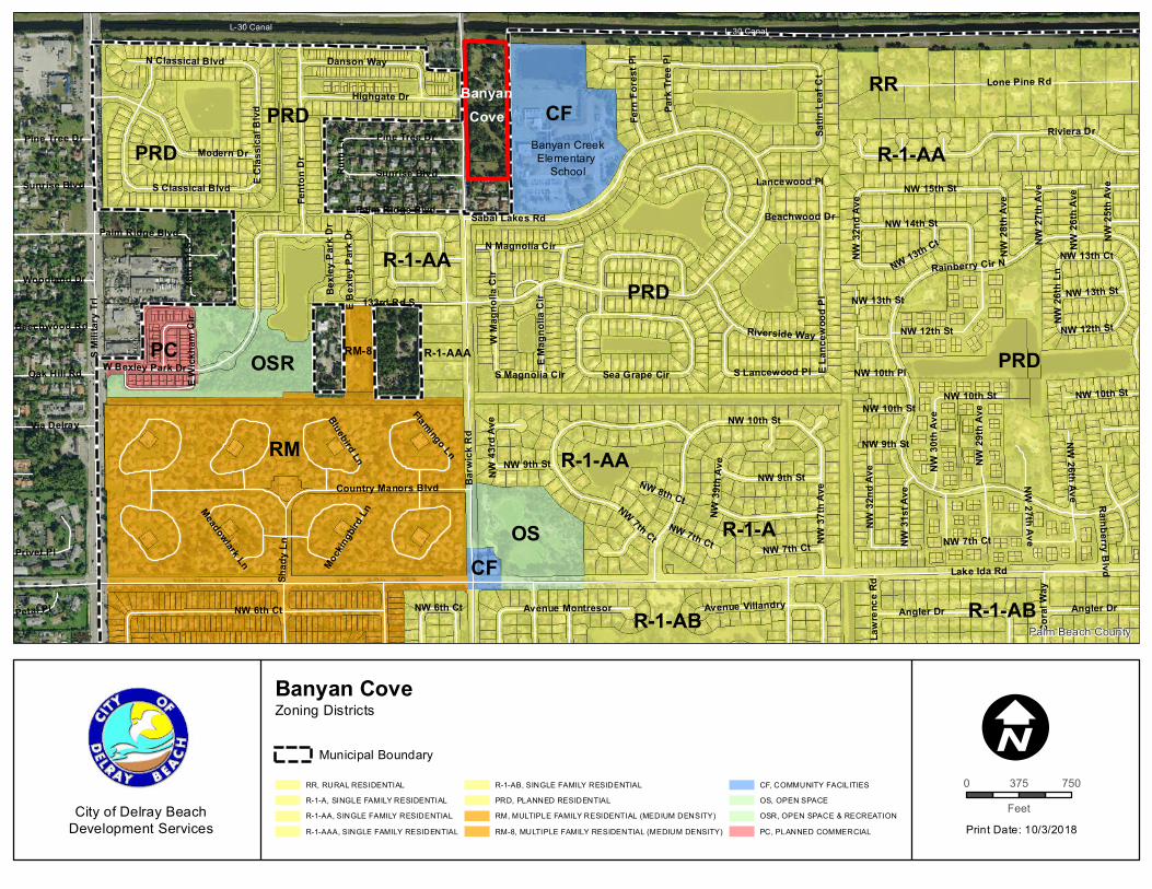
Banyan CreekElementary
School
BanyanCove
L-30 CanalL-30 Canal
PRD
PRD
RM
PC OSR RM-8
R-1-AA
R-1-AAA
RR
R-1-AA
R-1-A
R-1-AB
OSCF
PRD
PRD
R-1-AB
R-1-AA
CF
Lake Ida Rd
Barw
ick R
d
S Milit
ary T
rl
NW 6th Ct
Rainberry Cir N
NW 10th St
Lone Pine Rd
Sabal Lakes Rd
Fent
on D
r
Country Manors Blvd
W Bexley Park Dr
NW 7th Ct
Satin
Leaf
Ct
Angler Dr
Highgate Dr
NW 15th St
133rd Rd S
E Lan
cewo
od P
l
NW 29
th Av
e
NW 37
th Av
eNW 9th St
Danson Way
NW 14th St
Pine Tree Dr
Sunrise Blvd
Riverside Way
NW 26th Ave
Palm Ridge Blvd
Via Delray
W Ma
gnoli
a Cir
Modern DrRiviera Dr
Shad
y Ln
NW 32
nd Av
e
S Classical Blvd
NW 13th Ct
Sea Grape Cir
N Classical Blvd
Oak Hill Rd
Privet Pl
E Clas
sical
Blvd
NW 30
th Av
e
N Magnolia Cir
Avenue Villandry
Cora
l Way
Avenue Montresor
NW 12th St
48th
Trl S
NW 25
th Av
e
Petal Pl
Woodland Dr
E Mag
nolia
Cir NW 13th St
Park
Tree
Pl
S Lancewood Pl
Fern
Fore
st Pl
NW 26
th Ln
NW 31
st Av
e
NW 28
th Av
e
Beechwood Rd
Lawr
ence
Rd
E Bex
ley P
ark D
r
Bluebird Ln
NW 10th Pl
NW 27
th Av
e
S Magnolia Cir
Flamingo Ln
Beachwood Dr
Ruth
Ln
Rainberry Blvd
Meadowlark Ln Mockin
gbird
Ln
Lancewood Pl
NW 8th Ct
Bexle
y Par
k Dr
NW 39
th Av
e
E Wick
ham
Cir
NW 43
rd Av
e
NW 13th St
Pine Tree DrNW
27th AveNW 7th Ct
NW 12th St
NW 10th StNW 10th St
Angler Dr
NW 13th Ct
NW 9th St
Palm Ridge Blvd
NW 6th Ct
NW 26
th Av
e
NW 7th CtNW 7th Ct
Sunrise Blvd
NW 9th St
NW 10th St
NW 32
nd Av
e
Palm Beach County
0 750375Feet
Print Date: 10/3/2018
ICity of Delray Beach
Development Services
Banyan Cove
RR, RURAL RESIDENTIALR-1-A, SINGLE FAMILY RESIDENTIALR-1-AA, SINGLE FAMILY RESIDENTIALR-1-AAA, SINGLE FAMILY RESIDENTIAL
R-1-AB, SINGLE FAMILY RESIDENTIALPRD, PLANNED RESIDENTIALRM, MULTIPLE FAMILY RESIDENTIAL (MEDIUM DENSITY)RM-8, MULTIPLE FAMILY RESIDENTIAL (MEDIUM DENSITY)
CF, COMMUNITY FACILITIESOS, OPEN SPACEOSR, OPEN SPACE & RECREATIONPC, PLANNED COMMERCIAL
Zoning Districts
Municipal Boundary
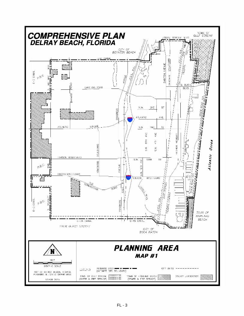
FL - 3
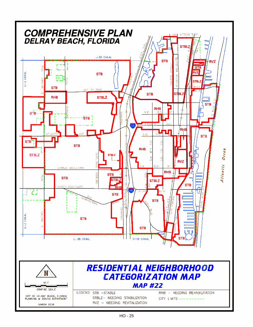
HO - 25
`
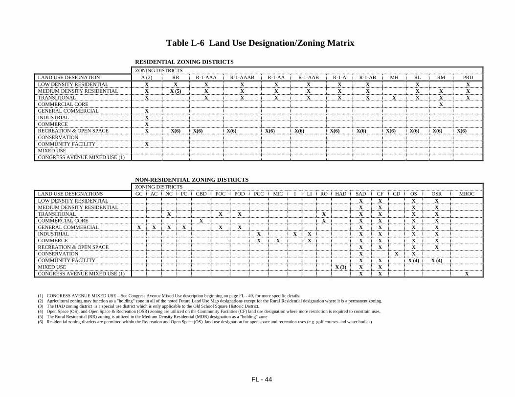
FL - 44
Table L-6 Land Use Designation/Zoning Matrix
RESIDENTIAL ZONING DISTRICTS
ZONING DISTRICTS
LAND USE DESIGNATION A (2) RR R-1-AAA R-1-AAAB R-1-AA R-1-AAB R-1-A R-1-AB MH RL RM PRD
LOW DENSITY RESIDENTIAL X X X X X X X X X X
MEDIUM DENSITY RESIDENTIAL X X (5) X X X X X X X X X
TRANSITIONAL X X X X X X X X X X X
COMMERCIAL CORE X
GENERAL COMMERCIAL X
INDUSTRIAL X
COMMERCE X
RECREATION & OPEN SPACE X X(6) X(6) X(6) X(6) X(6) X(6) X(6) X(6) X(6) X(6) X(6) CONSERVATION
COMMUNITY FACILITY X
MIXED USE
CONGRESS AVENUE MIXED USE (1)
NON-RESIDENTIAL ZONING DISTRICTS
ZONING DISTRICTS
LAND USE DESIGNATIONS GC AC NC PC CBD POC POD PCC MIC I LI RO HAD SAD CF CD OS OSR MROC
LOW DENSITY RESIDENTIAL X X X X
MEDIUM DENSITY RESIDENTIAL X X X X
TRANSITIONAL X X X X X X X X
COMMERCIAL CORE X X X X X X
GENERAL COMMERCIAL X X X X X X X X X X
INDUSTRIAL X X X X X X X
COMMERCE X X X X X X X
RECREATION & OPEN SPACE X X X X
CONSERVATION X X X
COMMUNITY FACILITY X X X (4) X (4)
MIXED USE X (3) X X
CONGRESS AVENUE MIXED USE (1) X X X
(1) CONGRESS AVENUE MIXED USE – See Congress Avenue Mixed Use description beginning on page FL - 40, for more specific details.
(2) Agricultural zoning may function as a "holding" zone in all of the noted Future Land Use Map designations except for the Rural Residential designation where it is a permanent zoning.
(3) The HAD zoning district is a special use district which is only applicable to the Old School Square Historic District.
(4) Open Space (OS), and Open Space & Recreation (OSR) zoning are utilized on the Community Facilities (CF) land use designation where more restriction is required to constrain uses.
(5) The Rural Residential (RR) zoning is utilized in the Medium Density Residential (MDR) designation as a "holding" zone
(6) Residential zoning districts are permitted within the Recreation and Open Space (OS) land use designation for open space and recreation uses (e.g. golf courses and water bodies)