Embed Size (px)
Citation preview
Planning and Environment Act 1987
Panel Report
Hume Planning Scheme Amendment C176
Municipal Strategic Statement Review
Front page
20 December 2016
Planning and Environment Act 1987
Panel Report pursuant to section 25 of the Act
Hume Planning Scheme Amendment C176
Municipal Strategic Statement Review
20 December 2016
Sarah Carlisle, Chair
Hume Planning Scheme Amendment C176 Panel Report 20 December 2016
Contents Page
1 Introduction ................................................................................................................... 1
1.1 The Amendment ...................................................................................................... 1 1.2 Background to the proposal .................................................................................... 1 1.3 Post‐exhibition changes ........................................................................................... 2 1.4 Issues dealt with in this report ................................................................................ 2
2 Planning context ............................................................................................................ 4
2.1 Policy framework ..................................................................................................... 4 2.2 Ministerial Directions and Practice Notes ............................................................... 5 2.3 Discussion ................................................................................................................ 6 2.4 Conclusion ................................................................................................................ 6
3 Kalkallo Retarding Basin ................................................................................................. 7
3.1 The issues ................................................................................................................. 9 3.2 Background .............................................................................................................. 9 3.3 Submissions ............................................................................................................. 9 3.4 Discussion .............................................................................................................. 10 3.5 Conclusions ............................................................................................................ 11 3.6 Recommendations ................................................................................................. 11
4 Activity centre hierarchy ................................................................................................ 7
4.1 The issue .................................................................................................................. 7 4.2 Background .............................................................................................................. 7 4.3 Submissions ............................................................................................................. 7 4.4 Discussion ................................................................................................................ 8 4.5 Conclusion ................................................................................................................ 8
5 Changes to the Urban Growth Boundary ...................................................................... 13
5.1 The issue ................................................................................................................ 13 5.2 Background ............................................................................................................ 13 5.3 Submissions ........................................................................................................... 14 5.4 Discussion .............................................................................................................. 14 5.5 Conclusions ............................................................................................................ 15 5.6 Recommendations ................................................................................................. 15
6 Other matters .............................................................................................................. 16
6.1 The issues ............................................................................................................... 16 6.2 References to future infrastructure projects ........................................................ 16 6.3 The National Airport Safeguarding Framework ..................................................... 17 6.4 Duplication of other growth area planning processes .......................................... 18 6.5 Cumulative impact assessment under the liquor licencing local policy ................ 19 6.6 Toolern Metropolitan Activity Centre and the Western Industrial
Precinct .................................................................................................................. 20 6.7 Bushfire issues ....................................................................................................... 20
Hume Planning Scheme Amendment C176 Panel Report 20 December 2016
6.8 Recommendations ................................................................................................. 21
Appendix A Submitters to the Amendment
Appendix B Changes to the current MSS
Appendix C Panel preferred version of the revised MSS
List of Abbreviations 2010 review Hume Planning Scheme Review 2010
Act Planning and Environment Act 1987
BMO Bushfire Management Overlay
CFA Country Fire Authority
DEDJTR Department of Economic Development, Jobs Transport and Resources
HIGAP Hume Integrated Growth Area Plan
LPPF Local Planning Policy Framework
MAC Metropolitan Activity Centre
MSS Municipal Strategic Statement
NASF National Airport Safeguarding Framework
PPN04 Planning Practice Note 4 Writing a Municipal Strategic Statement
PSP Precinct Structure Plan
PTV Public Transport Victoria
SPPF State Planning Policy Framework
UGB Urban Growth Boundary
VPA Victorian Planning Authority
VPP Victoria Planning Provisions

Hume Planning Scheme Amendment C176 Panel Report 20 December 2016
Overview
Amendment Summary
The Amendment Hume Planning Scheme Amendment C176
Common name Municipal Strategic Statement Review
Brief description The Amendment seeks to:
- replace the Municipal Strategic Statement with a new MSS - incorporate a new Liquor Licencing Local Policy (Clause 22.20)
- delete the redundant Interim Telecommunication Conduit Policy (Clause 22.18)
Subject site All land in Hume
Planning Authority Hume City Council
Authorisation 3 May 2016
Exhibition 24 May to 24 June 2016
Submissions Number of Submissions: 8 (one opposed, all requested changes)
1. Public Transport Victoria 2. Department of Economic Development, Jobs Transport and
Resources 3. Victorian Planning Authority 4. Country Fire Authority 5. Melbourne Water 6. Mitchell Shire Council 7. City of Melton 8. MAB Corporation Pty Ltd (opposed)
Panel Process
The Panel Sarah Carlisle
Directions Hearing 18 October 2016, 1 Spring Street, Melbourne
Panel Hearing 29 November 2016, 1 Spring Street, Melbourne
Site Inspections As the Amendment affects all land in the municipality, there were no site inspections
Appearances Hume City Council represented by Ms Sarah Kernohan and Ms Alex Lobaza
Date of this Report 20 December 2016
Hume Planning Scheme Amendment C176 Panel Report 20 December 2016
Executive Summary
(i) Summary
Hume Planning Scheme Amendment C176 (the Amendment) seeks to replace the existing Municipal Strategic Statement (MSS) with a new MSS that builds on existing local strategic policy with recently adopted Council strategies. It also seeks to introduce a new Liquor Licensing Local Policy, and remove a redundant Interim Telecommunications Conduit Local Policy.
The Amendment implements (in part) the findings of the Hume Planning Scheme Review 2010 (the 2010 review), which recommended (among other things) a comprehensive review of the MSS and Local Planning Policies. The Amendment implements Stage 1 of the 2010 review. An amendment to implement Stage 2 (a comprehensive review of Local Planning Policies) is anticipated in the first half of 2017.
Submissions raised issues associated with:
the activity centre hierarchy within the municipality
the Kalkallo Retarding Basin
criteria for amending the Urban Growth Boundary
duplication of planning policy or processes for parts of the municipality subject to separate strategic reviews or processes (such as growth areas)
references to uncommitted and unfunded infrastructure projects
support and implementation of the National Airports Safety Framework
the requirement for a Cumulative Impact Assessment for applications for a permit for licensed premises.
After considering all submissions, the Panel concludes that the revised MSS presents a clear vision and strategies that will guide future amendments and permit applications over the next four years and beyond. The Amendment is largely supported by, and implements, the State Planning Policy Framework including Plan Melbourne, and is consistent with the relevant Ministerial Directions and Practice Notes. The Amendment is well founded and strategically justified, and the Amendment should proceed, subject to a number of changes.
The Panel makes the following findings:
The Amendment requires some adjustments to ensure that the activity centre hierarchy reflected in Plan Melbourne is appropriately reflected.
References in the revised MSS to the Kalkallo Retarding Basin as a location for a potential hospital and university should be removed.
Further consideration should be given to the appropriateness of referencing Sunbury Town Centre as a location for a potential hospital and tertiary education facility.
References to the criteria for amendments to the Urban Growth Boundary are not appropriate for inclusion in a MSS, and should be removed.
References to as yet unfunded and uncommitted infrastructure projects in the revised MSS are appropriate, provided the status of such projects is made very clear.
Hume Planning Scheme Amendment C176 Panel Report 20 December 2016
The Amendment appropriately responds to strategic planning processes for growth areas and other areas subject to separate specific strategic planning reviews.
The requirement for a Cumulative Impact Assessment for applications for licensed premises in areas where clusters of licensed premises exist is appropriate.
(ii) Recommendations
Based on the reasons set out in this report, the Panel recommends that Hume Planning Scheme Amendment C176 be adopted as exhibited, subject to the following changes:
Amend the Municipal Strategic Statement to remove references to the Kalkallo 1.Retarding Basin as a location for a potential hospital or university.
Before adopting the Amendment, Council should give further consideration to: 2.a) whether the Strategic Framework Plan in Clause 21.01 should clearly
identify Sunbury’s position as an Activity Centre in the activity centre hierarchy; and
b) the appropriateness of Strategies 11.3 and 11.5 in Clause 21.02‐3 in the Municipal Strategic Statement, which reference Sunbury Town Centre as a location for a potential hospital or tertiary education facility.
Amend the Municipal Strategic Statement to remove Strategy 4.3 in Clause 21.02‐3.2, Strategy 10.2 in Clause 21.02‐3, and Clause 21.02‐5, which reference criteria for changes to the Urban Growth Boundary.
Amend the Municipal Strategic Statement to more clearly define the level of 4.commitment to infrastructure projects.
Make other drafting changes set out in the Panel’s preferred version of the 5.Municipal Strategic Statement in Appendix C of this report.
Hume Planning Scheme Amendment C176 Panel Report 20 December 2016
Page 1
1 Introduction
1.1 The Amendment
The Amendment proposes to:
replace the existing Municipal Strategic Statement (MSS) at Clause 21 of the Hume Planning Scheme with a new MSS
introduce a new Liquor Licensing Local Policy (Clause 22.20)
remove the existing Interim Telecommunication Conduit Policy (Clause 22.18).
The revised MSS includes changes to the structure of the existing MSS, as well as adding new and updated content. The changes are summarised in the table in Appendix B.
The Explanatory Report for the Amendment states:
The revised MSS articulates the vision of Hume Horizons 2040 (Hume Community Plan) and the Hume Integrated Growth Area Plan strategies, and includes land use and planning objectives and strategies to achieve these visions. It also identifies further strategic work and other Council actions, particularly around advocacy for the timing and delivery of major infrastructure, to further assist in facilitating Council’s strategic framework and liveability objectives.
1.2 Background to the proposal
The Amendment implements (in part) the findings of the Hume Planning Scheme Review 2010 (the 2010 review), undertaken in accordance with section 12B of the Planning and Environment Act 1987 (the Act). The 2010 review was the first comprehensive review of the entire scheme since the introduction of the New Format Hume Planning Scheme in 2000.
Earlier reviews of the MSS were completed in 20031, and 20062. Council had significantly progressed a comprehensive review of the MSS in 2008 but, before it completed the review, Melbourne @ 5,000,000 was released. As Melbourne @ 5,000,000 made significant changes to the State Planning Policy Framework, Council resolved to progress policy neutral revisions to the MSS in early 20093, and to undertake a fresh comprehensive review in light of Melbourne @ 5,000,000. This led to the 2010 review.
The 2010 review was undertaken by Council with assistance from Aecom Consultants. The report comprehensively considers background and contextual information, an audit of the scheme’s performance, consultation with key stakeholders (including the community) and Council’s strategic planning work program at the time.
The 2010 review found that the MSS needed to be updated to be consistent with State Government policy and legislation, and reflect Council’s vision and strategic direction. The 2010 review also found that Council’s Local Planning Policies in Clause 22 of the scheme
1 This MSS review was implemented by Amendment C58 in May 2005. 2 This MSS review was implemented by Amendment C70 in June 2006. 3 Amendment C110 was gazetted in November 2009.
Hume Planning Scheme Amendment C176 Panel Report 20 December 2016
Page 2
need to be reviewed to remove redundant policies and reflect current best practice in drafting of local content in planning schemes.
The Amendment is the first stage of implementing the 2010 review. An amendment to implement the second stage (a full review of Clause 22) is anticipated in the first half of 2017. In the meantime, the Amendment proposes two changes to Clause 22 ahead of the full local policies review:
inclusion of a new Liquor Licencing Local Policy (Clause 22.20)
removal of the now redundant Interim Telecommunications Conduit Local Policy (Clause 22.18).
1.3 Post‐exhibition changes
Council proposed various changes to the Amendment in response to submissions. Council also proposed several policy neutral clarifications to the exhibited MSS4. Council provided a version of the MSS incorporating all of these post‐exhibition changes (in mark‐up) on 22 November 2016. The Panel, in considering the revised Amendment, has accepted these changes and has not revisited them except where expressly raised in submissions and addressed in this report. This report focuses primarily on the unresolved issues raised in submissions, and the Panel’s recommendations relate to the revised post‐exhibition version of the MSS.
1.4 Issues dealt with in this report
In its written directions dated 20 October 2016, the Panel directed Council to address the following key issues through its Part B submission:
Details of Council’s activity centre hierarchy, and how that is supported by state and local strategic planning documents.
The strategic justification for the Kalkallo Retarding Basin accommodating higher order uses that might otherwise be accommodated in activity centres.
Any update on discussions Council may be having with Melbourne Water regarding the future role of the Kalkallo Retarding Basin.
The rationale for the inclusion of clause 21.02‐5, which sets out policy guidelines for proposals to change the Urban Growth Boundary, and whether that approach has been adopted in any other metropolitan fringe planning schemes.
The Panel considered all written submissions made in response to the exhibition of the Amendment, as well as further submissions and other material presented to it during the Hearing.
This report deals with the issues under the following headings:
Planning context
Activity centre hierarchy
Kalkallo Retarding Basin
Changes to the Urban Growth Boundary
4 Post‐exhibition changes in response to submissions were documented in Appendix 2 to Council’s Part A
submission, while Council’s policy‐neutral post‐exhibition changes were documented in Appendix 3 to Council’s Part A submission.
Hume Planning Scheme Amendment C176 Panel Report 20 December 2016
Page 3
Other matters
The Panel’s preferred version of the revised MSS, incorporating the Panel’s recommendations and some general drafting suggestions, is set out in Appendix C.
Hume Planning Scheme Amendment C176 Panel Report 20 December 2016
Page 4
2 Planning context
Council provided a response to the Strategic Assessment Guidelines as part of the Explanatory Report. That response is not repeated here.
2.1 Policy framework
(i) The State Planning Policy Framework
Council submitted that the structure of the revised MSS is generally (although not completely) consistent with the structure and themes of the SPPF. The revised MSS is structured to provide clear and concise guidance around the spatial arrangement of future land uses in the two growth areas within the municipality (Sunbury and the Hume Corridor). Clause 21.02 (Urban Structure and Settlement) sets the broad framework for urban development in the municipality, while the remaining clauses sit logically underneath Clause 21.02.
(ii) Hume Horizons and the HIGAPs
The key strategic policy documents underpinning the revised MSS are Hume Horizons 2040 (Council’s Community Plan), the Sunbury Integrated Growth Area Plan Spatial Strategy and Delivery Strategy, 2012 (the Sunbury HIGAP) and the Hume Corridor Integrated Growth Area Plan Spatial Strategy and Delivery Strategy, 2015 (the Hume Corridor HIGAP).
Hume Horizons was adopted by Council on 26 May 2014, following extensive community and stakeholder consultation. It outlines the long‐term vision for Hume, and guides the development and implementation of the Council Plan, service plans and individual strategies and policies. It outlines five key themes, which have been incorporated at Clause 21.01 (Municipal Profile) of the revised MSS, under the heading ‘Strategic Vision’.
The greatest influences on the municipality in the coming 25 years are the anticipated growth in the Hume Corridor and Sunbury growth areas. The two HIGAP strategies have been developed to guide and manage this growth. The revised MSS articulates the vision of the HIGAPs at Clause 21.01 (Municipal Profile), and includes objectives and strategies to achieve these visions.
(iii) Other strategic policy documents
The revised MSS is also based on the following strategic policy documents, several of which arose out of the recommendations of the 2010 review:
Guidelines for Development of Scenic Hilltops and Major Ridgelines Policy, Hume City Council, 1991 (amended 1995)
Mt Ridley Local Structure Plan for Inter Urban Break Mickleham, Greenaway and Katz Pty Ltd, 1997
Healthy by Design: a planners’ guide to environments for active living, National Heart Foundation of Australia, 2004
Hume Green Wedge: A Sustainable Lifestyle Landscape, Final Report for Phase One of the Hume Green Wedge Management Plan, Context Pty Ltd, 2007
Industrial Stormwater Code of Practice, Hume City Council, 2008
Hume Planning Scheme Amendment C176 Panel Report 20 December 2016
Page 5
Hume City Retail Strategy, Final Report, 2009
Hume Open Space Strategy 2010‐2015, Hume City Council, 2010
Hume Integrated Land Use and Transport Strategy 2011‐2020, Hume City Council, 2011
Broadmeadows Structure Plan, Hume City Council, 2012
Hume Walking and Cycling Strategy 2010‐2015, Hume City Council, 2012
Hume Natural Heritage Strategy 2011‐2015, Hume City Council, 2012
Hume Economic Development Strategy 2030, Hume City Council, 2012
Hume Responsible Gaming Policy, Hume City Council, 2013
Hume Liquor Licensing Referral Policy, Hume City Council, 2013
Melbourne Airport Master Plan, Australia Pacific Airports Melbourne, 2013
Hume Central: The Vision, 2014
Hume Development Goals, Hume City Council, 2015
Hume Bicycle Network Plan, Hume City Council, 2015
Hume Parking Management Policy 2015, Hume City Council, 2015
Hume Land and Biodiversity Plan 2015‐2019, 2015
Hume Biodiversity Planning Policy, Hume City Council, 2016.
(iv) The Hume Liquor Licencing Referral Policy
Council adopted the Hume Liquor Licensing Referral Policy in 2013, to guide decision making when a planning permit application is required for new and existing licensed premises. The Amendment presents an opportunity to incorporate the 2013 Liquor Licencing Policy into the scheme, rather than waiting until the full local policy review amendment.
(v) The Interim Telecommunications Conduit Local Policy
The Interim Telecommunications Conduit Local Policy dealt with the provision of fibre cabling for broadband communications in new subdivisions. This policy is now redundant following the introduction of new mandatory provisions at Clause 66.01‐1 of the Victorian Planning Provisions (VPPs).
2.2 Ministerial Directions and Practice Notes
The Panel considers that the Amendment meets the relevant requirements of Ministerial Direction No 11 Strategic Assessment of Amendments.
Planning Practice Note 4 Writing a Municipal Strategic Statement (PPN04) is relevant to the Amendment. PPN04 clarifies the role of a MSS in planning schemes, guides the preferred format of a MSS and guides how a MSS should be written. PPN04 references Chapter 9 (Plain English) of Using Victoria’s Planning System.
PPN04 encourages a MSS to use the SPPF themes, as this reinforces the strategic linkages between the SPPF and the MSS, helps with navigation and improves the ease of use of the scheme. Although the revised MSS largely reflects the themes of the SPPF, it does not do so exactly. The Panel accepts Council’s explanation for the variances (refer to section 2.1(i) above).
Hume Planning Scheme Amendment C176 Panel Report 20 December 2016
Page 6
2.3 Discussion
Sections 12A and 12B of the Act set out requirements that must be met in a MSS and a planning scheme review.
A MSS must:
further the objectives of planning in Victoria
be consistent with the Council Plan
contain: - the strategic planning, land use and development objectives of the planning
authority - the strategies for achieving the objectives - a general explanation of the relationship between those objectives and
strategies and the controls on the use and development of land in the planning scheme.
A review of the planning scheme must ensure that the scheme:
enhances the effectiveness and efficiency of the planning scheme in achieving planning objectives
is consistent in form and content with Ministerial Directions issued under section 7
sets out effectively the policy objectives for use and development of land in the municipality
gives effect to State planning policy objectives.
The revised MSS clearly sets out Council’s vision for the future use and development of the municipality. It contains clear strategic planning objectives and strategies for achieving those objectives. Council has applied good practice drafting principles based on the advice in PPN04. The Panel is satisfied that the revised MSS meets the requirements of sections 12A and 12B of the Act and PPN04, and considers that the revised MSS will effectively guide future amendments and permit applications over the next four years and beyond.
The revised MSS is generally consistent with the State Planning Policy Framework including Plan Melbourne, although some adjustments are required to ensure that the MSS appropriately reflects the activity centre hierarchy set out in Plan Melbourne, and the roles of some of the centres within that hierarchy. These issues are discussed in detail in Chapters 3 and 4.
2.4 Conclusion
The Panel concludes that the Amendment is supported by, and implements, the State Planning Policy Framework, and is consistent with the relevant Ministerial Directions and Practice Notes. The Amendment is well founded and strategically justified, and the Amendment should proceed subject to addressing the more specific issues discussed in the following chapters. The Panel also recommends some general drafting improvements which are marked up in Appendix C to this report.
Hume Planning Scheme Amendment C176 Panel Report 20 December 2016
Page 7
3 Activity centre hierarchy
3.1 The issue
The issue is:
whether the MSS appropriately reflects the activity centre hierarchy in the municipality.
3.2 Background
Plan Melbourne identifies two Metropolitan Activity Centres (MACs) in Hume —Broadmeadows (existing) and Lockerbie (future). It also identifies seven Activity Centres in Hume — Craigieburn Plaza, Craigieburn Town Centre, Gladstone Park, Roxburgh Park, Sunbury, Mickleham (future) and Sunbury South (future). The activity centre hierarchy in Plan Melbourne is broadly reflected in the HIGAPs.
3.3 Submissions
Council submitted that the revised MSS reflects the hierarchy in Plan Melbourne and the HIGAPs, with the exception of Craigieburn Plaza. Craigieburn Plaza is shown as an Activity Centre in Plan Melbourne and the Hume Corridor HIGAP, while the revised MSS identifies it as a Neighbourhood Centre.
Council explained that Craigieburn Plaza is a small activity centre with approximately 10,000 square metres of retail floor space, located in an established area with limited capacity to expand. The economic viability of the centre has been in decline for some time, which has been compounded by the opening in 2013 of the new Craigieburn Town Centre approximately 2.5 kilometres away. Council submitted that due to the size and locational constraints of Craigieburn Plaza, along with the proximity and planned growth of the Craigieburn Town Centre, the appropriate role of Craigieburn Plaza within the activity centre hierarchy is that of a neighbourhood centre.
MAB Corporation submitted that the MSS inappropriately emphasises the Lockerbie Town Centre as the primary activity centre in the northern part of the Hume Growth Corridor. It submitted that both the Hume Corridor HIGAP and Plan Melbourne Refresh preference the Mickleham (Merrifield) Town Centre as the higher order centre. It submitted that Figure 1 in Clause 21.01 (Regional Context Map) does not recognise Merrifield as an employment node or city centre/activity centre, and that references to the 2009 Retail Strategy in the MSS are outdated, as the activity centre hierarchy has evolved since 2009.
Council responded that Lockerbie Town Centre, as a MAC, sits higher in the activity centre hierarchy than the Mickleham (Merrifield) Town Centre and that the emphasis on Lockerbie in the MSS is therefore appropriate. Council submitted that it is premature to anticipate any changes to the activity centre hierarchy that might arise from Plan Melbourne Refresh. The better approach is to revise the MSS if required once the Plan Melbourne Refresh process is complete.
Hume Planning Scheme Amendment C176 Panel Report 20 December 2016
Page 8
3.4 Discussion
Subject to the issues discussed in the following Chapter, the Panel considers that the MSS appropriately reflects the positions of the Lockerbie and Merrifield Town Centres and Craigieburn Plaza in the activity centre hierarchy.
Lockerbie, as the only MAC, remains the primary activity centre in the northern part of the Hume Growth Corridor. Contrary to MAB Corporation’s submission, the Plan Melbourne Refresh Discussion Paper does not express any preference for Merrifield as the higher order centre. While it refers to the possibility of reclassifying Lockerbie as a future Activity Centre (rather than a future MAC), this is only an ‘option for discussion’. The Panel agrees with Council that it would be premature at this stage to alter the status of either Lockerbie or Merrifield on the basis of the Plan Melbourne Refresh Discussion Paper.
The Panel does not consider that the HIGAPs provide any strategic planning justification for elevating the status of Merrifield in the activity centre hierarchy. The HIGAPs are not incorporated into the planning scheme, and they have no statutory status as reference documents. As has been recognised by previous panels (for example, the Panel for Macedon Ranges C84), reference documents do no more than provide background or supporting information that will assist in understanding the basis for a MSS. They are not a substitute for appropriate policy content in the MSS or the scheme.
Council has agreed to alter Figure 1 in Clause 21.01 (Regional Context Map) in response to MAB Corporation’s submission, to show Merrifield as an ‘existing development’ area rather than a growth area. The Panel does not consider that any of the other alterations MAB Corporation requested to Figure should be made. Figure 1 represents a very high level regional context plan based on existing conditions. While Merrifield might be an area under development, it does not yet constitute an existing employment node or city centre/activity centre, and at this stage it would be premature to identify it as such on Figure 1.
The Panel understands that the 2009 Retail Strategy is the current retail strategy adopted by Council, and considers that references in the MSS to the 2009 Retail Strategy are appropriate.
3.5 Conclusion
The Panel concludes:
Apart from the issues discussed in Chapter 4, the MSS appropriately describes the position of the Lockerbie and Merrifield Town Centres and Craigieburn Plaza in the retail hierarchy.
Hume Planning Scheme Amendment C176 Panel Report 20 December 2016
Page 9
4 Kalkallo Retarding Basin
4.1 The issues
The issues are:
the appropriateness of identifying the Kalkallo Retarding Basin as a location for future higher order uses including a university, hospital and State scale sporting facility
whether the identification of State scale facilities at the Kalkallo Retarding Basin undermines the role of Lockerbie Town Centre as a MAC.
4.2 Background
The Kalkallo Retarding Basin is a 380 hectare parcel of land owned by Melbourne Water, located directly north of the Mickleham (Merrifield) Town Centre. The land is currently used for drainage purposes, and comprises a substantial portion of the land forming the future Merrifield North PSP. Plan Melbourne identifies the Kalkallo Retarding Basin land as the future ‘Merrifield Regional Park’. The Northern Growth Corridor Plan identifies the land as regional active open space under investigation, while recognising the ongoing drainage function of the land.
The Victorian Planning Authority (VPA) is preparing a Master Plan for Merrifield Park as a precursor to the Merrifield North PSP process. To date the VPA has prepared a draft vision statement, principles and spatial concepts for Merrifield Park. Once finalised, the Master Plan will set out the preferred use and development of the land. Council and Melbourne Water are members of the agency reference group for the Master Plan.
The revised MSS identifies both the Kalkallo Retarding Basin and the Lockerbie Town Centre as locations for a potential hospital, university and regional sports facility – refer to Strategy 6.1 in Clause 21.02 (Urban Structure and Settlement), and Clause 21.05 (Activity Centres).
4.3 Submissions
Melbourne Water submitted that the Kalkallo Retarding Basin is a critical piece of infrastructure that is required for flood protection. It submitted that discussions between Melbourne Water, the VPA and Council regarding the future of this land are ongoing, and it is premature to identify the future use of this land for a hospital, arts centre (which is no longer proposed), university and state scale sports facility.
Mitchell Shire Council submitted that the identification of the Kalkallo Retarding Basin as the location for a potential university and hospital undermines the Lockerbie Town Centre’s role as a future MAC. Mitchell submitted that the proper location for these sorts of higher order health and education facilities is a MAC, and that there is no strategic support in State policy for these uses to be located at the Kalkallo Retarding Basin.
The VPA also expressed some concern about the identification of potential sites for hospitals and universities on the Strategic Framework Plan in Clause 21.01, submitting that “some of the locations … may not be entirely suitable”.
Hume Planning Scheme Amendment C176 Panel Report 20 December 2016
Page 10
MAB Corporation, on the other hand, expressed concern that the revised MSS contemplates these facilities being located at Lockerbie, when the Hume Corridor HIGAP supports these facilities being located at Merrifield.
Council submitted that the identification of these potential land uses at Kalkallo Retarding Basin is consistent with State and local policy:
Plan Melbourne and the Northern Growth Corridor Plan identify the land as the location for regional active open space (consistent with a State scale sports facility)
the Hume Corridor HIGAP identifies the land as the location for a potential sports facility, university and hospital.
Council submitted that the Kalkallo Retarding Basin has a number of advantages over the Lockerbie Town Centre as the preferred location for a future hospital and university. The Kalkallo Retarding Basin presents “a significant and unique opportunity, given its ownership, potential for surplus land, and proximity to the future Merrifield Town Centre, to provide State scale facilities for the entire northern metropolitan region of Melbourne”. The Merrifield Town Centre is more advanced in its development than Lockerbie, as are the transport links to the Merrifield Town Centre.
4.4 Discussion
Plan Melbourne supports the location of universities and hospitals in a MAC, rather than in (or adjacent to) an Activity Centre. Universities and hospitals are functionally aligned with the strategic direction for a MAC as set out in Table 1 in Plan Melbourne. They also service a regional catchment, which is another feature of a MAC described in Plan Melbourne (whereas Plan Melbourne describes Activity Centres as servicing a subregional catchment).
The MSS does not express a clear preference for the Lockerbie MAC as a location for a potential university or hospital. If anything, the Panel considers that the revised MSS favours the Merrifield Town Centre (or the adjacent Kalkallo Retarding Basin) as the preferred location. This is certainly the case when the MSS is read together with the Hume Corridor HIGAP, which expresses a clear preference for Merrifield in multiple sections. For example, Section 3.6 of the HIGAP states:
Map 3.6 shows a hospital and university in and adjoining Mickleham (Merrifield) Town Centre. This is the preferred location for such facilities with Donnybrook (Lockerbie) Town Centre a reserve location and a suitable location for other large tertiary health and education facilities, potentially ones that are entirely privately funded. This preference differs from current State planning policy but as outlined in Box 3.6, Mickleham (Merrifield) Town Centre has a number of potential advantages over the Donnybrook (Lockerbie) Town Centre that have been underestimated to date by State Government.
The HIGAP then contains a number of strategies directed at ensuring that a public hospital and university are delivered at Merrifield – see for example the strategies in sections 3.6, 4.9 and 4.10.
The Panel considers that locating a university and hospital in (or adjacent to) an Activity Centre in preference to a MAC is inconsistent with Plan Melbourne. Plan Melbourne is State policy, and it is not the role of Hume City Council (or any other local council) to alter State
Hume Planning Scheme Amendment C176 Panel Report 20 December 2016
Page 11
policy, whether through the MSS or through other local strategic documents such as the HIGAP.
Further, the Panel considers that it is premature to identify the Kalkallo Retarding Basin as a location for a potential hospital or university at this stage. Melbourne Water has expressed concern that the identification of these uses in the Kalkallo Retarding Basin could undermine the drainage function of the land, and that more detailed planning is required to identify where (and how much) surplus land might be available in the Kalkallo Retarding Basin.
The Panel concludes that the MSS should be amended to remove references to the Kalkallo Retarding Basin as a location for a potential hospital or university.
The Panel reaches this conclusion notwithstanding that there is support in the Hume Corridor HIGAP for locating these facilities in the Kalkallo Retarding Basin. As noted in Chapter 3, the HIGAPs have no statutory status. Further, to the extent that the HIGAPs are inconsistent with Plan Melbourne, they should not be implemented, or reflected in the MSS.
The Panel notes that Strategies 11.3 and 11.5 in Clause 21.02‐3 promote and encourage the location of a hospital and tertiary education facility at Sunbury Town Centre, which is designated as an Activity Centre in Plan Melbourne. The Panel also notes that the Strategic Framework Plan in Clause 21.01 does not identify the Sunbury Town Centre’s position in the activity centre hierarchy.
The Panel has significant reservations about the appropriateness of encouraging a hospital and tertiary education facility in the Sunbury Town Centre, for the same reasons that the Panel considers it is inappropriate for the MSS to encourage these types of facilities to locate at (or adjacent to) the Merrifield Town Centre. The Panel also has concerns about the Strategic Framework Plan not clearly identifying Sunbury’s position in the activity centre hierarchy. No submissions were received in relation to these issues, so the Panel is limited in the extent to which it can comment or make recommendations. Nevertheless, the Panel recommends that Council reconsider these aspects of the MSS before adopting the Amendment.
4.5 Conclusions
The Panel concludes:
The revised MSS should be amended to remove references to the Kalkallo Retarding Basin as a location for a potential hospital or university.
Before adopting the Amendment, Council should give further consideration to the appropriateness of references to Sunbury Town Centre as a possible location for a university and a tertiary education facility. Council should also consider whether the Strategic Framework Plan should clearly identify Sunbury as an Activity Centre.
4.6 Recommendations
The Panel makes the following recommendations:
Amend the Municipal Strategic Statement to remove references to the Kalkallo 1.Retarding Basin as a location for a potential hospital or university.
Before adopting the Amendment, Council should give further consideration to: 2.
Hume Planning Scheme Amendment C176 Panel Report 20 December 2016
Page 12
a) whether the Strategic Framework Plan in Clause 21.01 should clearly identify Sunbury’s position as an Activity Centre in the activity centre hierarchy; and
b) the appropriateness of Strategies 11.3 and 11.5 in Clause 21.02‐3 in the Municipal Strategic Statement, which reference Sunbury Town Centre as a location for a potential hospital or tertiary education facility.
Hume Planning Scheme Amendment C176 Panel Report 20 December 2016
Page 13
5 Changes to the Urban Growth Boundary
5.1 The issue
The issue is:
whether it is appropriate to include criteria in the MSS for Council to support a change in the urban growth boundary.
5.2 Background
Changes to the Urban Growth Boundary (UGB) are determined by State Government, and must be approved by Parliament5. However, the growth area councils tend to be the first contact point for landowners requesting changes to the UGB. State government will typically consult with growth area councils in relation to proposals to change the UGB.
Council has developed a set of criteria that must be met for Council to support a change to the UGB. These are reflected in the Hume Corridor HIGAP, and in Clause 21.02 (Urban Structure and Settlement) of the MSS. Strategy 4.3 in Clause 21.02‐2 and Strategy 10.2 in Clause 21.02‐3 are:
Ensure that any proposal to change the Urban Growth Boundary considers the assessment criteria at 21.02‐5.
Clause 21.02‐5 states:
Any proposals for changes to the Urban Growth Boundary must demonstrably prove to the satisfaction of Council that:
There is a quantitative and qualitative need for the additional development land and substantive community benefit arising from changing the UGB.
Land within the current UGB could not meet this need and deliver comparable development opportunities and community benefits.
The change would protect and not undermine the integrity of areas of natural heritage significance and the ongoing viability of valued land uses, quarries and rural businesses.
There would be minimal impact on the 24 hour curfew free status of Melbourne Airport.
There is sufficient capacity within the existing arterial road, tertiary health and education infrastructure to appropriately support the full extent of development and/or there is new major infrastructure which is either committed in existing budgets or has an in principle funding commitment from the responsible agency to be delivered in step with development.
The development could access existing local community, education, health and recreation facilities with capacity to support development, as well as local shopping and public transport services or would deliver and viably support new facilities and services in step with development.
5 Part 3AA of the Act.
Hume Planning Scheme Amendment C176 Panel Report 20 December 2016
Page 14
The proposed boundary is based on holistic development areas and infrastructure, drainage and servicing catchments.
5.3 Submissions
The VPA and MAB Corporation submitted that it is inappropriate and unnecessary to include Council’s criteria for supporting changes to the UGB in the MSS. They submitted that changes to the UGB are determined by the State government subject to Parliamentary ratification and a comprehensive assessment process by State government. Clause 21.05 is therefore inappropriate as a local policy.
Council submitted that the criteria reflect State planning policy relating to urban growth (Clause 11.02), and that the intent of including the criteria is “to assist Council in considering the need and suitability of future changes to the UGB as and when a process for change is commenced by State government, or when landowners request Council’s support for such changes”. It submitted that including the criteria:
provides a fair and robust framework for Council to assess proposals to alter the UGB as part of any future State Government process
provides guidance for landowners seeking Council’s support for a change to the UGB (noting that changes are the responsibility of State government)
ensures that any proposed changes to the UGB will provide community benefit
provides greater certainty that any development of land subsequently included in the UGB is supported by adequate and timely funded infrastructure.
The Panel asked Council whether it was aware of this approach being adopted by any other growth area councils. Council responded that:
Council is not aware of other Councils applying similar policy guidelines within their MSS or Local Policies. However, it is not considered that the absence of similar policy guidance by other Councils should be a determining factor in whether the application of such policy guidance is appropriate within the local policy planning framework.
5.4 Discussion
The Panel agrees with submissions from the VPA and MAB Corporation that it is not appropriate for the MSS to identify criteria that must be met, to Council’s satisfaction, for a change in the UGB. Although Council will typically be consulted in relation to proposals to shift the UGB, it is not up to Council to determine what criteria should be met for changes to the UGB to be contemplated. This is the role of State government.
The Panel considers that there is some risk in including these criteria in the MSS. They may raise expectations that Council is able to consider changes to the UGB. They might not be consistent with the State government’s criteria for shifting the UGB, or those of other growth area councils. This could lead to confusion and unrealistic expectations among landowners who want the UGB shifted.
The Panel appreciates that Council is often the first point of contact for landowners wanting changes to the UGB, and that having a published set of criteria would assist Council in dealing with these enquiries. However, this is not the role of the MSS. If Council wishes to
Hume Planning Scheme Amendment C176 Panel Report 20 December 2016
Page 15
publish its criteria, it should do so elsewhere, and make it clear that they are Council’s (not the State government’s) criteria for supporting a State government proposal to shift the UGB.
5.5 Conclusions
The Panel concludes:
Strategy 4.3 in Clause 21.02‐2, Strategy 10.2 in Clause 21.02‐3, and Clause 21.02‐5 in its entirety, should be removed from the MSS.
5.6 Recommendations
The Panel makes the following recommendations:
Amend the Municipal Strategic Statement to remove Strategy 4.3 in Clause 21.02‐3.2, Strategy 10.2 in Clause 21.02‐3, and Clause 21.02‐5, which reference criteria for changes to the Urban Growth Boundary.
Hume Planning Scheme Amendment C176 Panel Report 20 December 2016
Page 16
6 Other matters
6.1 The issues
The issues are:
whether (and in what circumstances) it is appropriate for the MSS to refer to future infrastructure projects
whether the MSS adequately supports the National Airport Safeguarding Framework
whether the MSS duplicates other aspects of strategic planning for growth areas, such as the Growth Corridor Plans and Precinct Structure Plans (PSPs)
whether an application for a permit for licensed premises should require a Cumulative Impact Assessment
whether the MSS should identify and reference the Toolern MAC and the Western Industrial Precinct, which are located in the neighbouring municipality of Melton.
6.2 References to future infrastructure projects
(i) Background
The revised MSS includes references to a number of long term infrastructure projects (such as potential train stations and bus routes in growth areas, the Bulla Bypass and the Attwood Connector) which have not yet been committed to by the relevant agency, and are at this stage unfunded. References appear:
in the Strategic Framework Plan (Clause 21.01) and the Strategic Transport Plan (Clause 21.07)
as advocacy items in a number of Clauses.
(ii) Submissions
Public Transport Victoria (PTV) and the VPA do not support including infrastructure projects in the MSS until they are committed to by the relevant agency. The VPA submitted that retaining references to these items in the MSS “may provide an unrealistic view of projects which may not be deliverable”.
Conversely, the Department of Economic Development, Jobs, Transport and Resources (DEDJTR) has requested that the MSS include references to the Commonwealth Inland Rail project. It also submitted that buffers need to be in place around rail freight transport corridors, to ensure that surrounding land is not developed for competing or non‐compatible land uses.
Council submitted that the revised MSS identifies infrastructure that it believes is required to support the future growth of the municipality. It submitted that the infrastructure (including unfunded and uncommitted projects) is identified in the two HIGAPs, and that it is appropriate that the MSS illustrate Council’s strategic aspirations for future infrastructure.
Council submitted that including reference to the Inland Rail project will not assist the strategic direction of the MSS. It also submitted that it is premature to provide buffers along rail freight corridors until work is done to justify or confirm the extent of any proposed rail
Hume Planning Scheme Amendment C176 Panel Report 20 December 2016
Page 17
corridor buffers. Any rail freight corridor buffers should be introduced by the State Government as part of an amendment to introduce buffers across all planning schemes impacted by rail freight.
(iii) Discussion
The Panel agrees that it is appropriate to include references in the MSS to future infrastructure that Council has identified as needed to support the growth of the municipality, whether or not that particular infrastructure is committed to, or funded. However, it is important that unfunded and uncommitted projects are clearly identified as such, and as projects for which Council will advocate rather than as items than will be delivered. In particular, any such projects should be referred to as ‘potential’, not ‘proposed’.
As the Panel understands it, the alignment of the future rail freight corridors is not yet finalised. The Panel agrees with Council that identifying future buffers around these corridors is premature, and that (when the alignments are finalised), it is more appropriate for the State government to identify and put in place any required buffers across all affected planning schemes.
(iv) Conclusions
The Panel concludes:
Unfunded and uncommitted infrastructure projects can be included in the MSS, but the status of these projects must be made very clear.
It is premature to identify buffers for the future rail freight corridors in the MSS.
6.3 The National Airport Safeguarding Framework
(i) Background
The National Airport Safeguarding Framework (NASF) is a national land‐use planning framework that aims to minimise aircraft noise‐sensitive developments near airports. The SPPF includes policy guidelines relating to the NASF.
(ii) Submissions
DEDJTR submitted that the revised MSS does not address the NASF. Council responded that the MSS notes the importance of Melbourne Airport and makes multiple references to ensuring that use and development of land protects the Airport’s curfew free status, and is compatible with the operation of Melbourne Airport.
(iii) Discussion and conclusions
The Panel accepts Council’s submissions, and considers that the MSS adequately supports the NASF.
The Panel concludes:
No changes are required to the MSS to further support the NASF.
Hume Planning Scheme Amendment C176 Panel Report 20 December 2016
Page 18
6.4 Duplication of other growth area planning processes
(i) Background
The VPA is primarily responsible for growth area planning. The VPA is also undertaking strategic planning work in relation to the following areas within Hume (not all of which are located in growth areas):
Merrifield Park (the Kalkallo Retarding Basin) – refer to Chapter 4 above
Broadmeadows (the VPA is preparing a new Structure Plan for Broadmeadows)
the former Victoria University site at Jacksons Hill (the surrounding areas are being redeveloped as a residential area, and the VPA is in the early stages of preparing a Structure Plan for the Jacksons Hill site).
(ii) Submissions
The VPA submitted that the MSS should generally avoid providing guidance or direction in relation to existing or future PSP areas and other areas for which the VPA is undertaking strategic planning work. The VPA submitted that elements of the MSS replicate or duplicate the provisions of the SPPF and the Precinct Structure Planning Guidelines in relation to growth area planning, which is unnecessary and should be avoided. It requested a number of specific changes (for example, removing guidance relating to the management of heritage in growth areas, the provision of community and health facilities in new activity centres, and the location and alignment of roads on hilltops and ridgelines in growth areas).
Council submitted that the MSS establishes the strategic framework for the municipality, and should provide a holistic and cohesive policy framework for the entire municipality. Growth areas in particular are a significant part of the municipality, and removing strategic direction and guidance relating to growth areas would considerably weaken and erode the overarching policy framework that the MSS is intended to provide.
Council’s post‐exhibition changes to the MSS included rewording a number of strategies in response to specific concerns raised by the VPA.
(iii) Discussion and conclusion
The Panel agrees with Council that it would undermine the ability of the MSS to provide a comprehensive narrative for the strategic direction of the municipality as a whole to leave out areas that are subject to separate planning processes, or for which the VPA has strategic planning responsibility.
Council referred the Panel to the discussion in the Panel Report for Wyndham C192 of the treatment of growth area planning in an MSS (at page 9):
Strategies in the MSS should not contradict the SPPF and the Precinct Structure Plan Guidelines, but this does not mean that the MSS has to be silent on these issues.
Unless the SPPF and LPPF are integrated, there will always be a degree of overlap in policies if the MSS is to provide a coherent policy narrative. If an MSS did not address any issue already addressed in the SPPF it would
Hume Planning Scheme Amendment C176 Panel Report 20 December 2016
Page 19
contain many obvious policy gaps; this would not assist readers in understanding the policy that applies in a particular area.
This Panel endorses the approach of the Wyndham C192 Panel.
The Panel concludes:
It is not appropriate for the MSS to remain silent in relation to the strategic direction and guidance for the development of growth areas, or other areas within the municipality for which the VPA has strategic planning responsibility.
6.5 Cumulative impact assessment under the liquor licencing local policy
(i) Background
Clause 22.20‐4 (the new Liquor Licencing Local Policy) includes the following application requirement:
For applications where there is a clustering of licensed premises, a cumulative impact assessment is required. The cumulative impact assessment considers the likely impact of any existing licensed premises and the proposed licensed premises on the amenity of the surrounding area.
(ii) Submissions
MAB Corporation submitted that the requirement for a Cumulative Impact Assessment would result in delays and additional unnecessary cost. Council submitted that a Cumulative Impact Assessment would not result in excessive costs or time delays. It is an application requirement that only applies where a planning permit is triggered, and it is the type of assessment that a planning consultant could undertake as part of the preparation of the permit application.
(iii) Discussion and conclusion
The Cumulative Impact Assessment is only one of a number of application requirements that apply when a permit is triggered for a licensed premises. Other application requirements include detailed site and floor plans, a site context description, details of proposed management of the premises, and measures to ensure minimal amenity impacts from the premises. The decision guidelines contained in Clause 22.20‐5 for an application for licenced premises include the impact of the proposal on the mix of uses within the activity centre and the vitality and viability of the activity centre during the day and at night, and the impact of the proposal on the function, operation and economic viability of the activity centre.
The Panel considers that a Cumulative Impact Assessment would provide valuable information to assist the responsible authority when considering permit applications for licenced premises, including impacts on the vitality and viability of the activity centre.
The Panel concludes:
A Cumulative Impact Assessment should be required for applications for licenced premises where there is a clustering of licensed premises.
Hume Planning Scheme Amendment C176 Panel Report 20 December 2016
Page 20
6.6 Toolern Metropolitan Activity Centre and the Western Industrial Precinct
(i) Submissions
The City of Melton submitted that Figure 1 in Clause 21.01 (Regional Context Map) should reference the Toolern MAC and the Western Industrial Precinct (both of which are located in Melton), as Figure 1 shows the regional context. Council did not consider that the MSS would benefit from including references to these features, although it did not provide any rationale supporting its position.
(ii) Discussion and conclusions
The Panel does not consider that Toolern MAC or the Western Industrial Precinct should be specifically identified on Figure 1. Figure 1 only specifically identifies existing major employment areas, hospitals or transport gateways outside the municipality, and it would be inappropriate to identify MACs and industrial precincts in Melton, but not in other surrounding municipalities.
The Panel concludes:
Figure 1 in Clause 21.01 should not reference Toolern MAC or Western Industrial Precinct.
6.7 Bushfire issues
(i) Submissions
The CFA submitted that the following text should be added to the MSS:
Bushfire risk
The municipality encompasses areas of significant bushfire (grassfire) risk. It has been impacted by bushfire in the recent past and the risks persist today.
Objective
To assist in strengthening community resilience to bushfire and minimise environmental impacts.
Strategies
1.1 Encourage planning decisions to prioritise protection of human life and adopt a precautionary approach.
1.2 Consider the following principles for development in areas at risk of bushfire: direct development to locations of lower bushfire risk and away
from areas of high bushfire risk avoid development in areas of extreme bushfire risk (BMO) avoid development in areas where planned bushfire protection
measures may be incompatible with other environmental objectives.
Hume Planning Scheme Amendment C176 Panel Report 20 December 2016
Page 21
Council largely agreed, but reworded the CFA’s suggested Objective as follows (in Clause 21.03‐1 (Liveable Communities)):
To minimise the risk to life, property and the environment from flood and bushfire.
The MSS also includes the following additional strategies in relation to bushfire risk (in Clause 21.03‐1):
4.1 Ensure that subdivisions are appropriately designed to mitigate flood and bushfire risk.
4.2 Ensure that development is appropriately sited to provide protection from flood and bushfire.
(ii) Discussion and conclusion
The Panel has some concerns with the wording of the second dot point of the CFA’s suggested strategy 1.1. The Bushfire Management Overlay (BMO) does not identify areas of extreme fire risk. The purposes of the BMO are (among others) to identify where bushfire hazard warrants protection measures, and to ensure development is only permitted where the risk can be reduced to an acceptable level. In any event, Council advised at the Hearing that the BMO does not currently apply in Hume.
The Panel supports Council’s alternative wording of the bushfire Objective, and Council’s two additional strategies. However, the Panel considers that the bushfire and flood related objectives and strategies are more appropriately included in Clause 21.08 (Natural Environment and Environmental Risk), rather than Clause 21.03 (Liveable Neighbourhoods and Housing).
The Panel concludes:
the reference to the BMO in the CFA’s strategy 1.1 should be removed
the bushfire and flood related objectives and strategies should be relocated to Clause 21.08 of the MSS.
6.8 Recommendations
The Panel makes the following recommendations:
Amend the Municipal Strategic Statement to more clearly define the level of 4.commitment to infrastructure projects.
Make other drafting changes set out in the Panel’s preferred version of the 5.Municipal Strategic Statement in Appendix C of this report.
Hume Planning Scheme Amendment C176 Panel Report 20 December 2016
Page 22
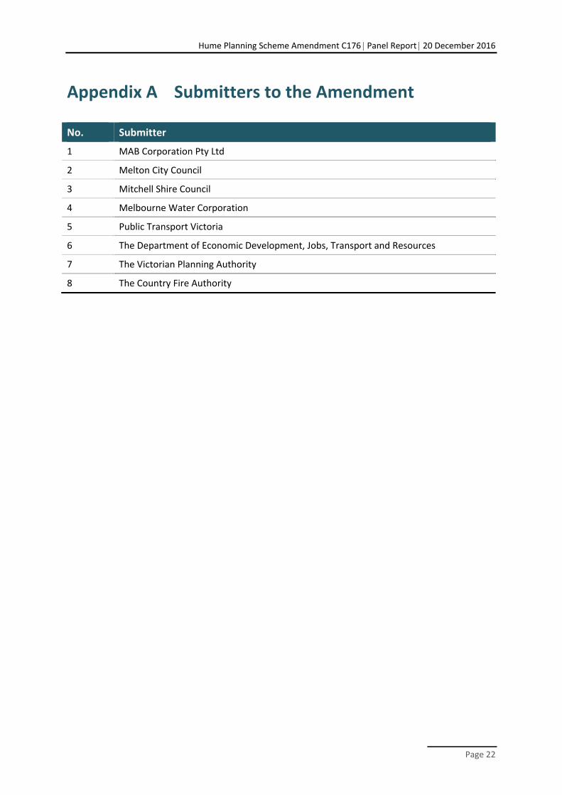
Appendix A Submitters to the Amendment
No. Submitter
1 MAB Corporation Pty Ltd
2 Melton City Council
3 Mitchell Shire Council
4 Melbourne Water Corporation
5 Public Transport Victoria
6 The Department of Economic Development, Jobs, Transport and Resources
7 The Victorian Planning Authority
8 The Country Fire Authority
Hume Planning Scheme Amendment C176 Panel Report 20 December 2016
Page 23
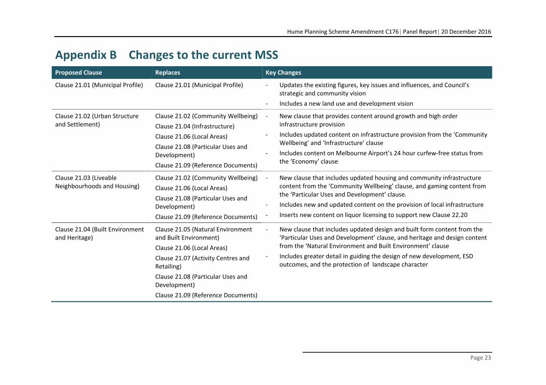
Appendix B Changes to the current MSS Proposed Clause Replaces Key Changes
Clause 21.01 (Municipal Profile) Clause 21.01 (Municipal Profile) ‐ Updates the existing figures, key issues and influences, and Council’s strategic and community vision
‐ Includes a new land use and development vision
Clause 21.02 (Urban Structure and Settlement)
Clause 21.02 (Community Wellbeing)
Clause 21.04 (Infrastructure)
Clause 21.06 (Local Areas)
Clause 21.08 (Particular Uses and Development)
Clause 21.09 (Reference Documents)
‐ New clause that provides content around growth and high order infrastructure provision
‐ Includes updated content on infrastructure provision from the ‘Community Wellbeing’ and ‘Infrastructure’ clause
‐ Includes content on Melbourne Airport’s 24 hour curfew‐free status from the ‘Economy’ clause
Clause 21.03 (Liveable Neighbourhoods and Housing)
Clause 21.02 (Community Wellbeing)
Clause 21.06 (Local Areas)
Clause 21.08 (Particular Uses and Development)
Clause 21.09 (Reference Documents)
‐ New clause that includes updated housing and community infrastructure content from the ‘Community Wellbeing’ clause, and gaming content from the ‘Particular Uses and Development’ clause.
‐ Includes new and updated content on the provision of local infrastructure
‐ Inserts new content on liquor licensing to support new Clause 22.20
Clause 21.04 (Built Environment and Heritage)
Clause 21.05 (Natural Environment and Built Environment)
Clause 21.06 (Local Areas)
Clause 21.07 (Activity Centres and Retailing)
Clause 21.08 (Particular Uses and Development)
Clause 21.09 (Reference Documents)
‐ New clause that includes updated design and built form content from the ‘Particular Uses and Development’ clause, and heritage and design content from the ‘Natural Environment and Built Environment’ clause
‐ Includes greater detail in guiding the design of new development, ESD outcomes, and the protection of landscape character
Hume Planning Scheme Amendment C176 Panel Report 20 December 2016
Page 24
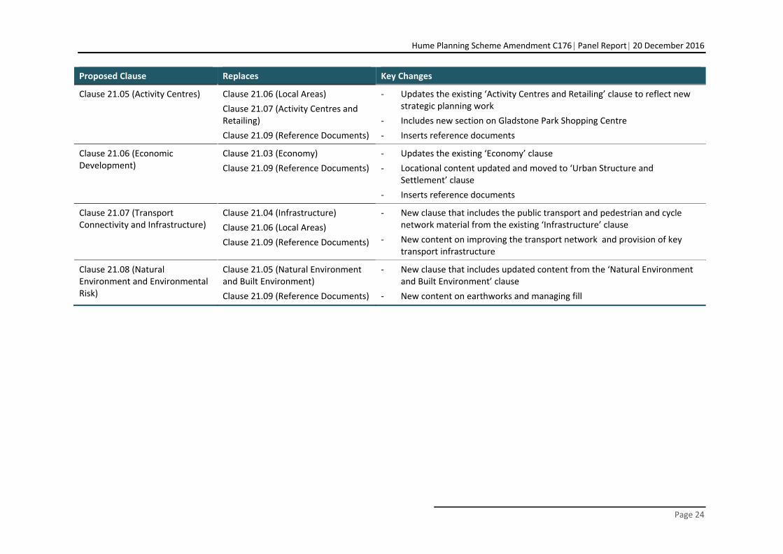
Proposed Clause Replaces Key Changes
Clause 21.05 (Activity Centres) Clause 21.06 (Local Areas)
Clause 21.07 (Activity Centres and Retailing)
Clause 21.09 (Reference Documents)
‐ Updates the existing ‘Activity Centres and Retailing’ clause to reflect new strategic planning work
‐ Includes new section on Gladstone Park Shopping Centre
‐ Inserts reference documents
Clause 21.06 (Economic Development)
Clause 21.03 (Economy)
Clause 21.09 (Reference Documents)
‐ Updates the existing ‘Economy’ clause
‐ Locational content updated and moved to ‘Urban Structure and Settlement’ clause
‐ Inserts reference documents
Clause 21.07 (Transport Connectivity and Infrastructure)
Clause 21.04 (Infrastructure)
Clause 21.06 (Local Areas)
Clause 21.09 (Reference Documents)
‐ New clause that includes the public transport and pedestrian and cycle network material from the existing ‘Infrastructure’ clause
‐ New content on improving the transport network and provision of key transport infrastructure
Clause 21.08 (Natural Environment and Environmental Risk)
Clause 21.05 (Natural Environment and Built Environment)
Clause 21.09 (Reference Documents)
‐ New clause that includes updated content from the ‘Natural Environment and Built Environment’ clause
‐ New content on earthworks and managing fill
Hume Planning Scheme Amendment C176 Panel Report 20 December 2016
Page 25
Appendix C Panel preferred version of the revised MSS
21.01 MUNICIPAL PROFILE
21.01-1 Locality and Regional Context
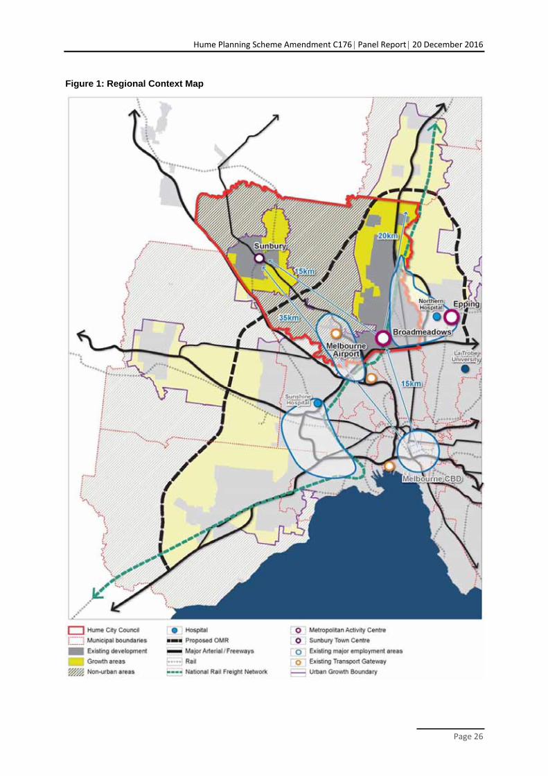
Hume City is located approximately 20 kilometres north-west of the Melbourne CBD and is one of Melbourne’s seven growth area municipalities. It is defined by two existing urban areas: the Hume Corridor in the east, and the township of Sunbury to the west of the Hume Corridor (refer to Figure 1). These two urban areas both contain green-field development fronts, and are clearly separated by significant areas of non-urban land, the township of Bulla and Melbourne Airport.
The City comprises an area of 504km² and is bound by the Merri Creek, Western Ring Road, Maribyrnong River, Calder Freeway and Jacksons Creek.
Hume, together with Whittlesea and parts of Mitchell, forms the Northern Growth Corridor which plays a crucial role in meeting the demands of Melbourne’s growing population. The Northern Growth Corridor will ultimately see the urban area of metropolitan Melbourne extended to encompass Beveridge and Wallan.
Sunbury, along with Diggers Rest (in the City of Melton) forms part of the Sunbury/Diggers Rest Growth Corridor.
Hume is a key gateway to the north of Melbourne and has excellent access to freeways and arterial roads, providing good accessibility to the Melbourne CBD, Melbourne Airport and the Port of Melbourne. Hume also has commuter rail links through the Upfield, Craigieburn and Sunbury lines, and freight links via the national rail line running from Melbourne to Sydney. The proposed Western Intermodal Freight Terminal and Beverage Intermodal Freight Terminal, whilst not located in Hume, will result in increased freight transport through the municipality. The proposed Outer Metropolitan Ring Road, when constructed, will run through Hume adjacent to the Hume Corridor.
Hume’s economy currently generates $27 billion worth of output and has a significant impact on Victoria’s economic performance. Hume is home to a number of employment areas including large strategic employment hubs within and around the Melbourne Airport and along the Hume Highway, which cater for much of the manufacturing, transport and logistics demands of Melbourne. Sunbury provides a smaller, but important, role in providing employment and meeting the economic needs of the wider Macedon Region.
Melbourne Airport is designated as a Transport Gateway and is one of Victoria’s key strategic assets and economic drivers. Directly employing around 12,500 people, it is one of the largest employment generators in Melbourne.
Broadmeadows and the future Donnybrook (Lockerbie) Town Centre are identified as Metropolitan Activity Centres. Broadmeadows is intended to strengthen its role as a key centre in the north, supporting the growing population of Hume and the wider Northern Subregion.
Hume supports a rich natural heritage including significant landscape features, such as creeks, escarpments and hill tops, areas of native vegetation and biodiversity, and a number of significant aboriginal cultural features.
xx/xx/20xx Proposed C176
xx/xx/20xx Proposed C176
Hume Planning Scheme Amendment C176 Panel Report 20 December 2016
Page 26
Figure 1: Regional Context Map
Hume Planning Scheme Amendment C176 Panel Report 20 December 2016
Page 27
21.01-2 Key Issues and Influences
The key issues and influences facing Hume are:
Population growth and changing demographics
Hume’s population is predicted to grow rapidly from about 198,500 in 2016 to 345,500 by 2041, and will ultimately be around 420,000 once all current growth area land is developed.
Population growth will primarily be driven by greenfield development in the growth areas of Greenvale, Craigieburn, Merrifield, Lockerbie and Sunbury, but also the intensification of established suburbs such as Broadmeadows.
Hume’s demographic profile is becoming more diverse in terms of age, household size and structure, ethnicity and household income.
The demographic profile of new growth areas will continue to be driven by young families, however established areas are aging and household sizes are shrinking.
The southern end of the Hume Corridor experiences greater levels of disadvantage, with Broadmeadows and Dallas ranking among Victoria’s most socially disadvantaged suburbs.
Housing and infrastructure needs
Changing demographics and economic factors is are generating the need for more diverse forms of housing to ensure that Hume’s residents have access to a range of appropriate and affordable housing that meets their housing needs as they change over time, and that they are able to remain and age in their local community.
Demand for greater housing diversity will affect suburbs differently, with more pronounced effects at the southern end of the Hume Corridor and around the Sunbury Town Centre where there is a larger ageing population and a greater number of smaller households.
A reduction in the average lot size in green-field development over the last decade is creating new suburbs with limited scope for future redevelopment opportunities.
The rate and scale of the growth is generating greater demand for state and federal funding towards major infrastructure, including critical transport infrastructure and higher order health, education, leisure and sports facilities, and for its timely delivery.
There is a need to ensure that development is sequenced to provide new communities with the timely access to local infrastructure. This includes the provision of local employment and shopping opportunities, and local health, recreation and community service and facilities.
There is a need to ensure that community infrastructure in established areas continues to meet the meed of the community as the demographics change.
Growing and diversifying the economy
Hume’s economy is dominated by the manufacturing, transport and logistics sectors, which together account for nearly half of Hume’s employment base, with limited job opportunities in professional services.
Lack of diversity and choice of jobs contributes to high levels of unemployment and results in large numbers of residents leaving the municipality to access work every day, especially from Sunbury.
It is critical that Hume’s employment base expands and diversifies to accommodate the anticipated decline of the manufacturing section, and the municipalities growing population.
Economic assessments identify an aspirational but realistic employment target for Hume should be to increase employment to of 150,000 jobs in the Hume Corridor and to 30,000 jobs in Sunbury. Achieving this will require large areas of new employment land, as well as new large scale office, health and education precincts. It will also require significant investment
xx/xx/20xx Proposed C176
Hume Planning Scheme Amendment C176 Panel Report 20 December 2016
Page 28
from the State in improved transport infrastructure to maintain accessibility and connect people to businesses, and in improved education and training facilities and services.
Protecting the operation of Melbourne Airport
The importance of the Melbourne Airport to the State’s economy, and the accessibility of Melbourne to global markets, depends upon the continued curfew free operation of the airport.
As the airport continues to grow it will attract significant demand for development in proximity to the airport. It will , however will also generate an increase in traffic generation and increased aircraft noise. Council recognises the need to achieve a balanced approach that protects the curfew free status of the airport and supports economic growth and, businesses, whilst at the same time minimising the impacts on existing residents.
The airport is currently the largest trip generator outside the Melbourne CBD. However however it suffers from limited public transport and road connectivity. As the airport continues to grow there will be an urgent need for better accessibility to the airport from both Sunbury and the Hume Corridor.
Improving the transport network
Population growth is exceeding the rate of improvement in the transport network and a number of arterial roads are operating above capacity.
The arterial road and freeway network is crucial to the economic success and productivity of Hume’s freight, transport and manufacturing businesses, particularly in the Hume Corridor. Maintaining the efficiency of the road network and improving east-west connectivity is crucial to maintaining Hume’s productivity, and for growing and attracting new businesses.
The lack of connectivity across Jacksons Creek and the rail line in Sunbury will become more problematic as Sunbury grows.
Hume’s community is highly car dependent, due to limited and infrequent public transport services, overcrowding on some train services, and limited walking and cycling opportunities.
A combination of land use changes and increased capacity in the transport network and public transport services is needed to assist in accommodating the anticipated scale of growth within Hume.
Protecting Hume’s natural and cultural heritage
There are many significant natural and cultural heritage features located throughout the municipality. A significant number are located within the Urban Growth Boundary, including in areas identified for future development in either existing or proposed Precinct Structure Plans.
The future growth of Hume has significant implications for the retention and protection of biodiversity and landscape values, as well as the conservation of cultural heritage.
Hume’s natural and cultural heritage needs to be carefully managed to ensure these assets are protected, whilst providing valuable opportunities for public access and leisure opportunities.
Improving the image of the Hume Corridor
The image and appearance of the Hume Corridor has been characterised by its industrial history which presents poor visual and amenity outcomes to long sections of the southern arterial road network and to key gateways into the municipality.
Protecting Sunbury’s character
Sunbury’s urban area is separated from Melbourne and the Hume corridor by non-urban areas. This physical separation, together with its rural setting, historic town centre, wide streets and
Hume Planning Scheme Amendment C176 Panel Report 20 December 2016
Page 29
generous public realm, assist in creating the sense that Sunbury is different and more like a regional town than a suburb of Melbourne.
Sunbury’s population is predicted to grow from over 35,000 currently to 80,000 by 2040, and ultimately will be over 100,000. While the opportunities presented by this change offer a benefit to the community in terms of infrastructure and employment opportunities, there is a need ensure that this growth is provided in a manner than maintains Sunbury’s unique township character.
Protecting non-urban land
Hume’s non-urban land is primarily zoned Green Wedge. This land provides a permanent break between the urban areas of the Hume Corridor and Sunbury, creates a distinct rural landscape character and outlook to the edge of the urban areas, and contains important conservation, natural resource and landscape features. It also helps protect the curfew free status of Melbourne Airport by limiting land uses that are affected by aircraft noise.
Farming has traditionally been a major land use in the non-urban areas, however over time a number of factors have combined to reduce its feasibility and profitability, and as a result farming has declined through the majority of the municipality. There is a need to provide long term certainty for landowners to make investment in rural businesses and land management activities.
The extent of non-urban land in Hume has reduced significantly in recent years as the Urban Growth Boundary has shifted. There is pressure for further expansion of the urban areas, particularly to the west of Mickleham Road.
The Urban Growth Boundary is an important tool in providing certainty around zoning and future potential land uses, and security for the continued curfew free operation of the aircraft flight path over Hume’s Green Wedge land.
There is demand for urban land uses seeking cheaper land that are more appropriately located in urban areas, such as independent schools, to locate in the non-urban areas of Hume due to cheaper land prices.
Global challenges
Global issues such as peak oil, climate change and resource scarcity will continue to affect all cities into the future, and resilience to these impacts should be at the forefront of planning and urban development in Hume.
21.01-3 Strategic vision
Council and community vision
Council has two important strategic plans, Hume Horizons 2040 (community plan) and the Hume Council Plan 2013-2017.
The Council Plan sets out the following ‘Vision’ and ‘Mission’ statements;:
Vision: Hume City Council will be recognised as a leader in achieving social, environmental and economic outcomes with a common goal of connecting our proud community and celebrating the diversity of Hume.
Mission: To enhance the social, economic and environmental prosperity of our community through vision, leadership, excellence and inclusion.
Council is committed to addressing the vision and mission through five strategic themes. These themes are central to both the Council Plan and Hume Horizons, and reflect community expectations and aspirations captured during consultation.
A well-educated and employed community
A healthy and safe community
xx/xx/20xx Proposed C176
Hume Planning Scheme Amendment C176 Panel Report 20 December 2016
Page 30
A culturally vibrant and connected community
A sustainably built and well-maintained City with an environmentally aware community
A well-governed and engaged community
Strategic planning aim
To ensure that Council’s planning and influence on land use and infrastructure provision appropriately manages change within the municipality and plays its role in addressing the previous five strategic themes, the ‘Aim’ for land use and development in Hume City is:
To ensure development in new and existing areas creates a highly liveable City, providing increased access and choice to a diverse range of housing, employment and regional facilities, and easy access to local everyday services and facilities.
To ensure growth occurs in a logical and timely manner, and is supported by the necessary major and local infrastructure to maximise the benefits of change to the community.
To ensure development creates a high quality built environment that is vibrant, visually interesting and sustainable, and is integrated with the natural environment in a manner that conserves and protects Hume’s significant biodiversity and landscape values, and provides greater public access for the community to enjoy these spaces.
Land use and development vision
The land uses and development visions below, along with the objectives and strategies in the following clauses, seek seeks to address Council’s strategic planning ‘Aim’.
The following land use and development visions reflect the ‘Hume Corridor’ and ‘Sunbury’ Hume Integrated Grown Area Plans (HIGAP). Both of these strategies seek to guide and manage growth and change within the municipality to 2040.
The land use and development ‘Vision’ for the Hume Corridor in 2040 is:
The Hume Corridor Area has changed its image as a peripheral and industrial location to a highly regarded and desirable part of Melbourne to both work and live.
New and existing residential areas offer not only affordable housing but affordable living with great amenity, a diversity of housing and easy access to local everyday services and facilities.
Broadmeadows is the focus for major office, retail and leisure development and together with new centres at Mickleham (Merrifield), Donnybrook (Lockerbie) and Craigieburn ensure residents throughout the Hume Corridor have a wide range of choices for shopping, employment, entertainment, health, education and cultural activities.
Employment precincts along the Hume Highway, Donnybrook Road and around Melbourne Airport are home to global, national, regional and local businesses in a diverse range of industries employing local people across a range of trades and professions.
Connecting residents and visitors throughout the north of Melbourne are regular and extended train services and numerous bus services many of which maximise the use of a dedicated busway along Aitken Boulevard.
The landscape and biodiversity features of the Hume Corridors are protected in connected conservation reserves and parkland areas. The public reserve network provides high quality opportunities at local and regional scales for the community to exercise, relax and enjoy nature.
The land use and development ‘Vision’ for Sunbury in 2040 is:
Sunbury is a unique township with a sense of community and familiarity. It is physically separate but well connected to Melbourne and the Hume Corridor by good transport links, including high frequency bus services and new train stations at Sunbury North and Sunbury South. An orbital link provides greater efficiency and connectivity within Sunbury.
The vibrant town centre along with a new centre on Sunbury Road is the focus for major office, retail and leisure development. These centres are supported by a network of neighbourhood centres that provide local convenience needs, are the hubs of activity throughout the day and
Hume Planning Scheme Amendment C176 Panel Report 20 December 2016
Page 31
evening, and are connected to adjoining residential and employment areas by good walking, cycling and public transport routes.
Access to a diverse range of jobs in employment areas along Vineyard Road and Sunbury Road, as well as a diversity of housing, and large and local scale health, education and leisure facilities, enable people to live and work in Sunbury throughout their lives.
Sunbury’s rural setting and natural and cultural heritage values are protected in connected conservation reserves and parkland areas. High levels of public access to these spaces are provided via walking and cycling paths around Sunbury’s hilltops and along the length of the Jackson Creek and Emu Creek corridors.
21.01-4 Strategic Framework Plan
The future urban structure of Hume can be seen in the Strategic Framework Plan at Figure 2. The Strategic Framework Plan reflects spatially the land use and development visions for Hume. Key elements of the plan include:
Existing and proposed land use;
Areas of potential future urban growth;
Significant hilltops, conservation and open space areas;
Identification and hierarchy of activity centre network;
Existing and proposed regional facilities;
Existing and proposed major transport infrastructure; and
Key gateway locations.
xx/xx/20xx Proposed C176
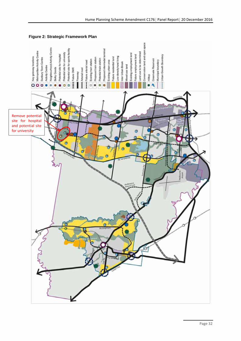
Hume Planning Scheme Amendment C176 Panel Report 20 December 2016
Page 32
Figure 2: Strategic Framework Plan
Remove potential site for hospital and potential site for university
Hume Planning Scheme Amendment C176 Panel Report 20 December 2016
Page 33
21.02 URBAN STRUCTURE AND SETTLEMENT
21.02-1 Managing Growth and Increasing Choice
Growth Corridor Plans and Plan Melbourne have been developed at the metropolitan level which sets set the strategic direction for the future urban development of land within Melbourne’s Urban Growth Boundary.
In a local sense, the Sunbury HIGAP Spatial Strategy (2012) and the Hume Corridor Integrated Growth Area Plan (HIGAP) Spatial Strategy (2015) provide long term strategies and infrastructure delivery plans for the two main growth corridors in the municipality.
The Growth Corridor plans and the two HIGAP strategies guide the preparation of more detailed precinct scale plans, including Precinct Structure Plans, structure plans and development plans. All these precinct scale plans confirm:
the location of town centres and community facilities;
estimated housing yields and the proposed location of higher density housing;
employment areas;
the detailed alignment of important roads;
local bus routes and their connections with Principal Public Transport Network (PPTN) and arterial road network;
best integrating land uses that best integrate with the transport network;
open space networks, recreation facilities and shared paths;
defining edges between urban development and areas of high biodiversity and cultural heritage significance, landscape or drainage significance; and
major sites or easements required for public utilities.
Precinct Structure Plans (PSPs) are being, or have been, developed for all of the growth areas within the Growth Corridor. Structure Plans and other precinct plans are been being developed for some activity centres and other residential and employment areas.
Key issues
Managing significant population growth.
Delivering higher density residential outcomes.
Providing jobs near where people live, especially near new employment areas.
Developing infrastructure in partnership with state and federal governments.
Providing major infrastructure that is required to meet the needs of the community in a timely manner.
Managing the impact of urban growth on the natural environment and heritage values.
Objective 1
To facilitate large scale change that meets the needs of Hume’s growing population and provides choice and equitable access to a range of housing, employment, transport, services and facilities.
Strategies
1.1 Ensure planning for large scale green-field communities in both the Hume Corridor and Sunbury provides a range of housing options with high quality new activity centres, schools, community facilities, leisure and recreation facilities, road and public transport options.
xx/xx/20xx Proposed C176
xx/xx/20xx Proposed C176
Hume Planning Scheme Amendment C176 Panel Report 20 December 2016
Page 34
1.2 Identify strategic development sites with good access to public transport that can accommodate increased dwelling densities and provide for smaller housing products.
1.3 Facilitate high density residential development within and around activity centres and train stations.
1.4 Facilitate the delivery of 150,000 jobs in the Hume Corridor and 30,000 jobs in the Sunbury area across a broad range of employment sectors, including new employment areas identified in Figure 2 in Clause 21.01.
1.5 Provide a hierarchy of activity centres in the locations shown in Figure 2 in Clause 21.01 that delivers deliver a wider range of retail, office, entertainment, leisure, health, educational and cultural opportunities in both the Hume Corridor and Sunbury.
1.6 Provide a network of specialist bulky goods based centres that service a regional catchment in the locations shown in Figure 2 in Clause 21.01.
1.7 Ensure high quality walking and cycling infrastructure is provided to improve mode choice and reduce car dependency for local trips.
1.8 Ensure a range of open space opportunities are provided to meet the leisure and recreation needs of the community.
Objective 2
To ensure that the planning for growth in Hume minimises the impact on the environment and heritage.
Strategies
2.1 Ensure biodiversity, landscape, heritage and waterway values are appropriately considered during the planning process.
2.2 Ensure new development maximises the retention of biodiversity, including scattered trees.
2.3 Protect the significant waterways, conservation and open space areas identified in Figure 2 in Clause 21.01.
2.4 Ensure waterways, conservation and open space areas are well integrated within the built environment and provide for appropriate community access.
Objective 3
To provide communities with access to critical transport infrastructure and regional facilities in step with growth.
Strategies
3.1 Coordinate and sequence development and infrastructure.
3.2 Provide communities with access to critical transport infrastructure and regional facilities.
3.3 Facilitate the timely provision of high quality and diverse retail, health, entertainment and leisure options within all activity centres.
3.4 Ensure that the planning and funding of regional facilities takes into account growth and existing facilities beyond municipal boundaries.
3.5 Limit new development where it exceeds the capacity of existing infrastructure, unless the existing infrastructure is to be upgraded or appropriate new infrastructure will be provided.
Further strategic work
Review and update approved Precinct Structure Plans where necessary to meet identified community needs.
Monitor growth in jobs against the job targets for the Hume Corridor and Sunbury areas.
Hume Planning Scheme Amendment C176 Panel Report 20 December 2016
Page 35
Monitor the capacity of major transport, education and health infrastructure in the Hume Corridor and Sunbury areas.
Other actions
Advocate for the timely delivery of upgrades to arterial roads and improved train and bus services to connect residents to employment areas, activity centres and other major destinations within and beyond Hume.
Advocate for the timely delivery of the Outer Metropolitan Ring Road.
21.02-2 Hume Corridor
The land use and development vision for the Hume Corridor in 2040 is set out in Clause 21.01-3. The proposed future urban structure of the Hume Corridor will support a significant increase in population, primarily located in the new growth areas of Greenvale, and Craigieburn in the middle of the corridor, and Mickleham (Merrifield) and Donnybrook (Lockerbie) at the northern end. In total these areas are anticipated to deliver over 40,000 new dwellings and 1,100 hectares of employment land, primarily located along the Hume Highway and Donnybrook Road. This equates to approximately 65 percent of the future growth in the Hume Corridor.
Serving these new areas will be the two large activity centres of Donnybrook (Lockerbie) Metropolitan Activity Centre and the Mickleham (Merrifield) Activity Centre, which will be the focus for higher order regional and sub-regional facilities, as well as an expanded Craigieburn Town Centre. These centres will be a focus for employment and will be connected to new bus services particularly via Aitken Boulevard and new train stations on the extended Craigieburn train line.
The southern end of the Hume Corridor will also accommodate increased population through infill development in established suburbs and the redevelopment of strategic development sites. Broadmeadows is identified as a Metropolitan Activity Centre and is the focus for major change within the established area of the Hume Corridor and wider Northern Subregion.
Existing employment land along the Hume Highway in Campbellfield and around the airport, and the existing intermodal freight terminal in Somerton continue to provide for and support the growth of Hume’s manufacturing, transport and logistic sectors. The Attwood Connector, a potential new link between the Pascoe Vale Road and the airport, will facilitate greater east-west connection between these major employment precincts.
New employment areas along the Hume Freeway and Donnybrook Road will form an extension to the State significant industrial precinct and provide for a range of employment and business opportunities.
The Inter Urban Break continues to provide a permanent separation between the urban areas of Craigieburn and Mickleham. Supporting low density rural residential development, it provides for the ecological connectivity between the Mt Ridley Conservation Reserve and conservation and open space areas in Craigieburn.
Significant biodiversity and landscape values that contribute to the corridor’s character and natural heritage are protected in conservation, open space and waterway areas. This includes extensions to the regional parkland along the Merri Creek, increased parkland around Greenvale Reservoir, and extensions to parkland along a number of other waterways.
Key issues
Managing significant population growth in the Hume Corridor.
Increasing the number and diversity of jobs in the Hume Corridor.
Providing communities with greater access to higher order facilities.
Protecting and promoting the operation of Melbourne Airport.
xx/xx/20xx Proposed C176
Hume Planning Scheme Amendment C176 Panel Report 20 December 2016
Page 36
Improving the Hume Corridor’s transport network to increase east-west connectivity across the Hume Corridor and provide greater connectivity to the Melbourne Airport and the Melbourne CBD.
Protecting areas of significant environmental value and improving public access to these places.
Objective 4
To plan for and enable large scale change within the Hume Corridor.
Strategies
4.1 Facilitate new residential and employment areas shown in Figure 2 in Clause 21.01 that are supported by a network of activity centres and high order facilities.
4.2 Manage the outward expansion of the Hume Corridor.
4.3 Ensure that any proposal to change the Urban Growth Boundary considers the assessment criteria at 21.02-5.
4.34 Facilitate Transit Oriented Development around existing and future train stations at Broadmeadows, Craigieburn and Lockerbie, and along Craigieburn Road east of the Craigieburn Town Centre.
4.45 Maintain existing subdivision patterns and discourage development that would prejudice the planning of future Precinct Structure Plan areas.
Objective 5
To increase the number and diversity of jobs in the Hume Corridor.
Strategies
5.1 Promote Broadmeadows and Donnybrook (Lockerbie) as Metropolitan Activity Centres and facilitate the delivery of higher order retail, commercial, health, educational, entertainment, leisure, community and cultural activities.
5.2 Promote Broadmeadows as Hume's primary activity centre and the focus for new office and professional service businesses.
5.3 Promote Craigieburn, Mickleham (Merrifield) and Donnybrook (Lockerbie) activity centres as important locations for office and professional service businesses.
5.4 Promote the Merrifield Employment Area as a high quality business park suitable for businesses across a range of sectors.
5.5 Encourage business growth around the Melbourne Airport in transport and logistics, wholesale trade and other sectors that require immediate access to the airport.
5.6 Promote the employment land along the Hume Highway, Hume Freeway and Donnybrook Road as a major employment location for a range of transport and logistics and manufacturing uses.
5.7 Facilitate the development of multi-use intermodal terminals and designated freight precincts at Somerton.
5.8 Discourage the development of bulky goods retail premises in existing and future industrial areas outside of identified bulky goods centres shown in Figure 2 in Clause 21.01.
Objective 6
To secure the delivery of higher order health, recreation and education facilities in the Hume Corridor.
Hume Planning Scheme Amendment C176 Panel Report 20 December 2016
Page 37
Strategies
6.1 Ensure land is identified for the delivery of a university and hospital or equivalent facilities in or adjoining Mickleham (Merrifield) and the Donnybrook (Lockerbie) Metropolitan Activity Centre activity centres.
6.2 Plan for expanded health facilities in Broadmeadows and Craigieburn.
6.3 Facilitate the development of a State scale sports and leisure hub at Merrifield Park.
6.4 Facilitate the extension of the Merri Creek Marran Baba Regional Park from Campbellfield to Lockerbie North.
6.5 Ensure development establishes a recreational loop around Greenvale Reservoir, that does not compromise the security of the drinking water quality.
Objective 7
To reinforce the role of Melbourne Airport as one of Victoria’s key economic assets.
Strategies
7.1 Support land use and development within the airport precinct that is consistent with its specialist function as a Transport Gateway.
7.2 Ensure that land use and development protects the airport’s curfew free status and is compatible with the operation of Melbourne Airport in accordance with the Melbourne Airport Master Plan.
Objective 8
To reinforce the role of the Inter Urban Break as a permanent separation and conservation and landscape buffer between conventional density development areas north and south.
Strategies
8.1 Maintain the Inter Urban Break for predominantly larger detached housing and low density rural residential development that supports the conservation of biodiversity and landscape values.
8.2 Facilitate the connectivity of conservation and open space areas through the Inter Urban Break.
8.3 Facilitate an additional north-south connector road through the Inter Urban Break between Mickleham Road and the future extension of Aitken Boulevard.
Objective 9
To ensure that the growth of the Hume Corridor is supported by an improved transport network.
Strategies
9.1 Facilitate the upgraded and extended arterial road and freeway network in Figure 1 in Clause 21.07.
9.2 Ensure land is identified for the Attwood Connector to provide improved road and public transport access to Melbourne Airport.
9.3 Promote increased north-south and east-west connectivity by a range of transport modes.
9.4 Ensure land is identified for a new train station at Campbellfield and Lockerbie.
9.5 Facilitate timely extensions and improvements to the bus network to serve new development areas.
Hume Planning Scheme Amendment C176 Panel Report 20 December 2016
Page 38
Further strategic work
Monitor the need for the development of the Attwood Land for a future business park.
Monitor the need to develop the land identified for employment development either side of Gunns Gully Road.
Investigate long term land uses for the closed Tullamarine landfill and associated buffer land.
Prepare plans for the development of Maygar Barracks and the Ford site to enable their renewal and reuse for employment generating uses.
Other actions
Advocate for the timely delivery of the transport network and regional infrastructure shown on in Figure 2 in Clause 21.01 and Figure 1 in Clause 21.07.
21.02-3 Sunbury
The land use and development vision for Sunbury in 2040 is set out in Clause 21.01-3. The proposed future urban structure of Sunbury will see the outward expansion of the existing township to include new growth areas in Sunbury East, Sunbury South, Sunbury North and Sunbury West. These growth areas will accommodate significant residential growth, and include new employment areas along Sunbury Road and Vineyard Road which will provide for a range of regional and local businesses.
The growth of Sunbury will be supported by an expanded Town Centre, a new activity centre in Sunbury South and a network of smaller activity centres throughout the growth areas. This growth, along with the potential for higher order regional facilities, will enable a greater level of self-containment for Sunbury’s community in terms of retail, education, health, recreation, community services and employment.
A new orbital road which provides connectivity across Jacksons Creek and the train line will enhance accessibility within the township, connect new activity centres with residential and employment areas, and minimise through traffic in the expanded Town Centre. The Bulla Bypass, upgrades to Sunbury Road, new train stations in Sunbury South and Sunbury North, and new train and bus services will increase connectivity to the Hume Corridor, the Melbourne Airport and inner areas of Melbourne.
Diggers Rest in the City of Melton enjoys a close relationship with the township of Sunbury, due to its location and proximity to the Sunbury Town Centre and the services that Sunbury offers.
Conservation and open space along Jacksons Creek and Emu Creek and their tributaries and escarpments as well as at Redstone Hill will protect areas of significant biodiversity and landscape value and contribute to the unique landscape and rural character of the Sunbury township.
Key issues
Managing significant population growth in Sunbury.
Providing jobs and higher order facilities that reduce the need for the community to leave Sunbury.
Improving Sunbury’s transport network to better connect different areas within Sunbury, as well as providing greater connectivity to the Hume Corridor, Melbourne Airport and the Melbourne CBD.
Protecting areas of significant environmental value and rural landscapes that are visually prominent.
Objective 10
To facilitate the growth of Sunbury while retaining its unique landscape and township qualities.
xx/xx/20xx Proposed C176
Hume Planning Scheme Amendment C176 Panel Report 20 December 2016
Page 39
Strategies
10.1 Facilitate new residential and employment areas that are supported by a network of activity centres and higher order facilities shown in Figure 2 in Clause 21.01.
10.2 Ensure that any proposal to change the Urban Growth Boundary considers the assessment criteria at 21.02-5.
10.23 Ensure that the planning of new areas within the Urban Growth Boundary considers the potential long term development of land between Watsons Road and the Outer Metropolitan Ring Road.
10.34 Support appropriately located higher density residential development in and around the Sunbury Town Centre and Sunbury train station.
10.45 Protect hilltops, escarpments, ridgelines and waterway corridors from development that could impact on the rural outlook and the landscape qualities of the township.
10.56 Ensure development proposals in the older parts of Sunbury sensitively integrate with the preferred neighborhood character.
10.67 Ensure the planning of the Victoria University Site at Jacksons Hill recognises, and protects and retains its historical and cultural significance.
10.78 Maintain existing subdivision patterns and discourage development that would prejudice the planning of future Precinct Structure Plan areas.
10.89 Facilitate complementary and compatible development that supports the continued operations of wineries in and around the Sunbury township.
Objective 11
To provide new employment opportunities and major education, health, leisure and recreation facilities within Sunbury that support growth and provide for a greater level of self-containment of the town.
Strategies
11.1 Promote the Sunbury Town Centre as a Regional Activity Centre with expanded higher order retail, commercial, entertainment, leisure, community and cultural activities.
11.2 Promote the Sunbury Town Centre as an important office location and the preferred location for large scale professional service businesses.
11.3 Promote the Sunbury Town Centre as the preferred location for a hospital or equivalent and a tertiary education facility within the town.
11.4 Ensure the planning of the Victoria University Site at Jacksons Hill retains an educational role.
11.5 Safeguarded Safeguard land for a hospital or equivalent and a tertiary education facility in proximity to the proposed Sunbury North train Station.
11.6 Ensure land is identified for a regional sports facility in the vicinity of the proposed Sunbury North train station.
11.7 Ensure that planning for the major new employment area on Sunbury Road adjoining the Hi-Quality Quarry provides for a range of manufacturing, transport and logistics, and business service uses.
11.8 Facilitate the development of Sunbury Business Park on Vineyard Road for a range of industrial uses.
11.9 Facilitate a new bulky goods node and employment area along Vineyard Road adjoining the Calder Freeway.
11.10 Facilitate new regional parks along Jacksons Creek and Emu Creek, and at Redstone Hill and Mount Holden.
Hume Planning Scheme Amendment C176 Panel Report 20 December 2016
Page 40
Objective 12
To ensure that the growth of Sunbury is supported by an improved transport network.
Strategies
12.1 Facilitate the delivery of the transport network shown in Figure 1 in Clause 21.07, including advocating for elements of the network shown in Figure 1 that are as yet unfunded or uncommitted to by the relevant agency.
12.2 Facilitate good access and connectivity between areas within Sunbury by all modes of transport.
12.3 Provide for improved connections to Diggers Rest, the Hume Corridor, Melbourne Airport, Broadmeadows and inner areas of Melbourne.
12.4 Facilitate an orbital loop through Sunbury comprising Elizabeth Drive, the Northern and Southern Links across Jacksons Creek, Lancefield Road and Sunbury Road.
Further strategic work
Monitor the need for the development of the land between Watsons Road and the Outer Metropolitan Ring Road to meet employment needs.
Other actions
Advocate for the timely delivery of the regional infrastructure in Figure 2 in Clause 21.01.
Advocate for the timely delivery of the transport network in Figure 1 in Clause 21.07.
Work with Melton Shire Council to facilitate the delivery of a new employment area north of Diggers Rest-Coimadai Road.
Work with VicTrack in designing walking and cycling links along the rail line to link residential areas of Sunbury and Diggers Rest with the train station, the neighbourhood activity centre and other facilities within this precinct.
Work with VicRoads to extent extend the existing shared path along Vineyard Road to connect to (and over) the Calder Freeway.
21.02-4 Non-Urban Land
Hume’s non-urban land (green wedge) will continue to provide clear separation and distinction between the urban areas of the Hume Corridor and Sunbury, providing improved connectivity via the Bulla Bypass, Outer Metropolitan Ring Road and the potential extension of Craigieburn Road to Lancefield Road.
The green wedge will support land uses which provide for the sustainable and economically viable ongoing management of the land. Uses are to be compatible and sympathetic to the rural and landscape character of the land, and take into account the presence of the Melbourne Airport Environs Overlay and the need to maintain the airports curfew-free status.
Key issues
Maintaining the quality of environmental values in green wedge areas.
Providing for appropriate land uses that maintain the sustainability and viability of green wedge areas.
Erosion around Sunbury.
Objective 13
To protect the role and enhance the viability of Hume’s non-urban areas.
xx/xx/20xx Proposed C176
Hume Planning Scheme Amendment C176 Panel Report 20 December 2016
Page 41
Strategies
13.1 Ensure the green wedge retains a physical separation between the Hume Corridor and Sunbury.
13.2 Support rural activities that provide for the sustainable and economical management of non-urban land.
13.3 Discourage the use of non-urban land for urban land uses that would be better located and supported within the Urban Growth Boundary.
13.4 Discourage small lot excisions and the construction of more than one house on allotments in the rural areas unless it can be demonstrated that there is a link with an established rural enterprise on the land.
13.5 Discourage small lot excisions and the construction of more than one house on allotments in the rural areas unless it will assist in the protection of biodiversity values or an identified heritage site.
13.6 Ensure any future planning of land north west of Sunbury recognises erosion and land management issues and the native vegetation and visual qualities of the area.
Objective 14
To limit the expansion of the Bulla township.
Strategies
14.1 Contain the development of Bulla within the existing township boundary.
14.2 Encourage the consolidation of smaller allotments in accordance with the Bulla Restructure Plan.
14.3 Support low density rural residential development within the Bulla township.
Further strategic work
Prepare a non-urban (rural) HIGAP spatial and delivery strategy.
21.02-5 Implementation
Policy guidelines
Any proposals for changes to the Urban Growth Boundary must demonstrably prove to the satisfaction of Council that:
There is a quantitative and qualitative need for the additional development land and substantive community benefit arising from changing the UGB.
Land within the current UGB could not meet this need and deliver comparable development opportunities and community benefits.
The change would protect and not undermine the integrity of areas of natural heritage significance and the ongoing viability of valued land uses, extractive industries and rural businesses.
There would be minimal impact on the 24 hour curfew free status of Melbourne Airport.
There is sufficient capacity within the existing arterial road, tertiary health and education infrastructure to appropriately support the full extent of development and/or there is new major infrastructure which is either committed in existing budgets or has an in principle funding commitment from the responsible agency to be delivered in step with development.
The development could access existing local community, education, health and recreation facilities with capacity to support development, as well as local shopping and public transport
xx/xx/20xx Proposed C176
Hume Planning Scheme Amendment C176 Panel Report 20 December 2016
Page 42
services or would deliver and viably support new facilities and services in step with development.
The proposed boundary is based on holistic development areas and infrastructure, drainage and servicing catchments.
21.02-65 Reference Documents
Healthy by Design: a planners’ guide to environments for active living, National Heart Foundation of Australia, 2004
Hume Corridor HIGAP Spatial Strategy and Delivery Strategy, Hume City Council, 2015
Hume Green Wedge: A Sustainable Lifestyle Landscape, Final Report for Phase One of the Hume Green Wedge Management Plan, Context Pty Ltd, 2007
Hume Integrated Land Use and Transport Strategy 2011-2020, Hume City Council, 2011
Hume Open Space Strategy 2010-2015, Hume City Council, 2010
Melbourne Airport Master Plan, Australia Pacific Airports Melbourne, 2013
Mt Ridley Local Structure Plan for Inter Urban Break Mickleham, Greenaway and Katz Pty Ltd, 1997
Sunbury HIGAP Spatial Strategy and Delivery Strategy, Hume City Council, 2012
Hume Land and Biodiversity Plan 2015-2019, 2015
xx/xx/20xx Proposed C176
Hume Planning Scheme Amendment C176 Panel Report 20 December 2016
Page 43
21.03 LIVEABLE NEIGHBOURHOODS AND HOUSING
21.03-1 Liveable Communities
Liveability is the sum of factors which shapes the ‘quality of life’ experienced in an area and the wellbeing of a community. This includes the quality of the built and natural environment, including its environmental sustainability and resilience to climate change, economic prosperity and social equity. It also includes access to a choice of everyday things that people require, including housing, employment, public transport and retail, health, education, recreation and cultural services and facilities.
While Melbourne’s inner areas are seen to be highly ‘liveable’, Hume’s community, like most growth areas, does not experience the same level of access and choice to the things that they require. It is vital that the growth of Hume provides existing and future populations with the level of access experienced in other areas of Melbourne.
The municipality encompasses areas of significant bushfire (grassfire) risk. It has been impacted by bushfire in the recent past and the risks persist today.
Key issues
Delivering the infrastructure that is needed to support liveable, connected and healthy communities in line with urban growth so that it does not place an unacceptable strain on existing infrastructure and services in established areas.
Meeting the infrastructure and service needs of young families in new growth areas and mature families and older persons in established areas.
Maintaining existing community infrastructure and ensuring it meets the needs of the community.
Minimising the impacts of gaming and liquor licencing on the health and wellbeing of the community.
Minimising bushfire fire risks to urban areas.
Objective 1
To ensure the provision of local infrastructure and services that meets the needs of the local community.
Strategies
1.1 Ensure the upgrade of existing community facilities to service the needs of the local community.
1.2 Ensure the equitable distribution of a range of community facilities.
1.3 Ensure the equitable distribution of a range of active and passive open space.
1.4 Ensure that developers contribute equitably to the provision of local infrastructure.
1.5 Facilitate the co-location of community facilities with complementary uses such as education, recreation and health services.
1.6 Ensure new activity centres provide opportunities for community and health facilities.
Objective 2
To coordinate and sequence development so that it provides communities with access to local infrastructure and services in a timely manner.
xx/xx/20xx Proposed C176
xx/xx/20xx Proposed C176
Hume Planning Scheme Amendment C176 Panel Report 20 December 2016
Page 44
Strategies
2.1 Ensure that neighbourhood subdivisions are staged to ensure the early delivery of activity centres that meet local convenience needs.
2.2 Discourage the expansion of existing activity centres that would delay delivery of new centres thereby reducing accessibility in new neighbourhood areas.
2.3 Ensure that the provision of community facilities and local active and passive open space is coordinated with the sequencing of residential development.
2.4 Facilitate options for the delivery of interim facilities in areas of significant growth with limited accessibility to existing services and facilities where appropriate.
2.5 Ensure the delivery of the necessary transport infrastructure to manage the impacts of new development.
2.6 Facilitate the upgrade of any access roads to the required urban standard from major roads.
2.7 Ensure developers construct footpaths, dedicated bicycle paths, shared paths and upgrade roads in line with their development to facilitate the timely delivery of walking and cycling networks.
Objective 3
To minimise the social impacts of liquor and gaming venues on Hume’s community.
Strategies
3.1 Manage the distribution, location, design and operation of licensed premises and gaming machines to reduce their amenity impacts.
Objective 4
To minimise the risk to life, property and the environment from flood and bushfire.
Strategies
4.1 Ensure that subdivisions are appropriately designed to mitigate flood and bushfire risk.
4.2 Ensure that development is appropriately sited to provide protection from flood and bushfire.
4.3 Encourage planning decisions to prioritise protection of human life and adopt a precautionary approach.
4.4 Consider the following principles for development in areas at risk of bushfire:
direct development to locations of lower bushfire risk and away from areas of high bushfire risk
avoid development in areas of extreme bushfire risk (BMO)
avoid development in areas where planned bushfire protection measures may be incompatible with other environmental objectives.
Policy guidelines
When deciding on an application for use, development or subdivision the following local policies will be considered, as appropriate:
Clause 22.17 Gaming.
Other actions
Work with health and community support providers to establish a presence in new activity centres.
Hume Planning Scheme Amendment C176 Panel Report 20 December 2016
Page 45
21.03-2 Housing
Overview
Hume’s housing stock is overwhelmingly dominated by large detached dwellings. The Hume housing market is primarily aimed at delivering homes for family households. While there is an expectation and an assumption that this will continue to remain true for new housing in the growth areas, there is a need for greater housing diversity. This includes demands for an increasing number of smaller households, to house an ageing population, and the community’s aspirations of being able to age in their local community.
Being an outer metropolitan municipality, and given large areas across the southern end of the Hume Corridor include development restrictions associated with the Melbourne Airport, the appetite and opportunity for medium and high density development is considerably less when compared with inner or middle metropolitan municipalities. Nevertheless, pressure for increased densities will change over time, and considerations for the retention of unique neighbourhood character will need to be balanced against the need for urban consolidation and the demand and need for greater housing diversity.
Key issues
Accommodating a projected population of approximately 345,500 by 2041.
Reducing the mismatch between Hume’s current housing supply and the demand for different types of housing generated by an increase in smaller, older and more diverse households.
Limited provision of apartment and attached townhouse dwellings through recent infill development.
Limited provision of one and two bedroom dwellings.
Uniformity of new subdivisions and the decreasing size of conventional lots provide limited opportunity for people to access different forms of housing as their housing needs change.
The need to consider ‘neighbourhood character’ when assessing infill development.
Objective 54
To increase the diversity of housing in Hume.
Strategies
4.1 Encourage well designed infill residential development that provides smaller housing product.
4.2 Encourage the development of one and two bedroom dwellings.
4.3 Encourage housing that is able to be adapted for different life stages or is suitable for the needs of an ageing household.
4.4 Ensure residential subdivisions provide a mix of lot densities, including larger lots and medium density development sites to facilitate a range of housing products.
4.5 Maintain the Inter Urban Break in the Hume Corridor and the Rolling Meadows areas in Sunbury for predominantly larger detached housing and low density rural residential development.
Policy guidelines
When deciding on an application for use, development or subdivision the following local policies will be considered, as appropriate:
Clause 22.07 Aged Accommodation and Services
Clause 22.13 Residential Neighbourhood Character - Sunbury
Clause 22.14 Residential Neighbourhood Character - Tullamarine
xx/xx/20xx Proposed C176
Hume Planning Scheme Amendment C176 Panel Report 20 December 2016
Page 46
Clause 22.15 Residential Neighbourhood Character - Westmeadows
Further strategic work
Prepare a Housing Strategy to guide the future planning for housing growth and diversity, including the application of zones and overlays to facilitate preferred housing outcomes.
21.03-3 Reference Documents
Healthy by Design: a planners’ guide to environments for active living, National Heart Foundation of Australia, 2004
Hume Corridor HIGAP Spatial Strategy and Delivery Strategy, Hume City Council, 2015
Hume Development Goals, Hume City Council, 2015
Hume Integrated Land Use and Transport Strategy 2011-2020, Hume City Council, 2011
Hume Liquor Licensing Referral Policy, Hume City Council, 2013
Hume Open Space Strategy 2010-2015, Hume City Council, 2010
Hume Responsible Gaming Policy, Hume City Council, 2013
Hume Walking and Cycling Strategy 2010-2015, Hume City Council, 2012
Sunbury HIGAP Spatial Strategy and Delivery Strategy, Hume City Council, 2012
Hume Land and Biodiversity Plan 2015-2019, 2015
xx/xx/20xx Proposed C176
Hume Planning Scheme Amendment C176 Panel Report 20 December 2016
Page 47
21.04 BUILT ENVIRONMENT AND HERITAGE
21.04-1 Urban Design
Urban design is the practice of shaping the layout, appearance and function of the built environment. It seeks to ensure that development responds to its context and that buildings, streets and public spaces are designed to work together to create a liveable city that supports a healthy, prosperous and sustainable community.
The image and appearance of the Hume Corridor has been characterised by its industrial history which presents poor visual and amenity outcomes to long sections of the southern arterial road network and to key gateways into the municipality. It is important that investment in the public realm and the redevelopment of housing, industrial and commercial development achieves better urban design outcomes and improves the image and appearance of Hume.
In addition, the scale of development in Hume’s growth areas means that there are new neighbourhoods, employment precincts, activity centres, community and recreation facilities being developed regularly. This provides an opportunity to ensure that right from the start the design and layout of these new areas is of high quality and achieves the best urban design outcomes.
Key issues
Altering the perception of the Hume Corridor as a manufacturing and logistics area and peripheral employment location.
Improving the interface of development to key roads particularly in industrial areas.
Improving the design and appearance of built form in industrial and commercial areas.
Balancing the tension in policy between urban consolidation objectives and the desire to respect residential amenity and neighbourhood character.
Minimising the loss of backyard areas and established vegetation where this is a strong part of the neighbourhood or landscape character.
Improving the design quality of infill development.
Improving the diversity and character of new residential area areas.
Recognising the role of activity centres, particularly in new areas, in creating a sense of place and defining the character of an area.
Ensuring the design of community facilities maximise their integration with adjoining compatible land uses and their contribution to the public realm.
Objective 1
To improve the image and appearance of Hume Corridor’s established areas and deliver high quality development in new growth areas across Hume.
Strategies
1.1 Ensure development located at key gateways into and within the municipality shown in Figure 2 in (see Clause 21.01) enhances the visual appearance of that location.
1.2 Ensure development adjacent to or visible from major roads and key transport routes is of a high quality and makes a positive contribution to the appearance, amenity and character of the area.
1.3 Ensure development addresses the street and provides an active interface to the public realm, including open space and creek corridors.
1.4 Ensure development is designed to follow the natural land form in areas with slope to minimise the need for cut and fill and the appearance of visual bulk.
xx/xx/20xx Proposed C176
xx/xx/20xx Proposed C176
Hume Planning Scheme Amendment C176 Panel Report 20 December 2016
Page 48
1.5 Encourage built form to incorporate architectural treatments and use of colours, materials and finishes that are visually interesting and engaging, particularly for industrial, commercial and high density residential development and in areas with a high volume of pedestrian traffic.
1.6 Encourage signage to be innovative, add interest to the locality and where possible be incorporated with built form.
1.7 Encourage public art in public spaces which contribute to a sense of place.
1.8 Ensure car parking that is visible from the public realm is designed to positively contribute to the image and amenity of the area.
1.9 Establish and maintain boulevard treatments along the entire length of Aitken Boulevard, Donnybrook Road, Sunbury Road/Macedon Street, Riddell Road, Vineyard Road/Horne Street, Gap Road and Lancefield Road.
1.10 Ensure the widening of Mickleham Road and Craigieburn Road protects existing trees in the road reserve and provides space for additional planting.
Objective 2
To enhance the amenity and appearance of industrial and commercial areas.
Strategies
2.1 Ensure new business parks and industrial precincts are designed to attract investment and provide businesses and workers with a high quality working environment.
2.2 Ensure redevelopment proposals in business and industrial areas enhance the visual appearance of the area.
2.3 Ensure that development is designed to carefully manage residential interfaces to minimise the impacts of built form, noise, traffic congestion, safety and pollution.
2.4 Ensure that office components of industrial and warehouse development front the street.
2.5 Encourage front fencing that is low and/or permeable.
2.6 Encourage loading and service areas to be located at the rear of sites, screened from the street and the public realm.
2.7 Discourage car parking in site frontages and encourage car parking areas to be located at the rear, softening the visual appearance of these areas through landscaping treatments including canopy trees.
2.8 Ensure business and industrial parks incorporate a strong landscaping regime in the public realm.
Objective 3
To enable well designed medium and higher density residential development that protects the amenity of existing residents and sensitively responds to identified preferred neighbourhood character.
Strategies
3.1 Ensure development in Sunbury, Tullamarine and Westmeadows reflects the preferred neighbourhood character identified in Clause 22.13, Clause 22.14 and Clause 22.15.
3.2 Ensure multi-level buildings are designed to provide an appropriate transition in scale to adjoining single storey building forms.
3.3 Encourage basement car parking in multi-level development where practical.
3.4 Ensure that buildings are sited and designed to follow the natural land form and minimise the need for cut and fill in areas of slope.
3.5 Encourage split level development on steep sloping land.
Hume Planning Scheme Amendment C176 Panel Report 20 December 2016
Page 49
3.6 Encourage and support well designed infill residential development in areas characterised by single and double storey detached dwellings.
3.7 Encourage infill development to retain the backyard realm in areas characterised by large backyard spaces.
3.8 Encourage front fencing that is low and/or permeable.
3.9 Ensure the redevelopment of corner sites includes side fencing that is designed to achieve a balance between providing privacy and maintaining visual connections to the public realm.
Objective 4
To create vibrant and attractive activity centres that contribute to the character of an area.
Strategies
4.1 Ensure that activity centres are designed to protect the amenity of residential and open space interfaces.
4.2 Ensure new neighbourhood activity centres are designed to be predominantly street based and include opportunities for a range of small businesses to locate outside of the supermarket and specialty retail core.
4.3 Ensure that the first stages of development in new activity centres are designed to allow for the integration of future development on adjoining land parcels.
4.4 Ensure development provides active frontages to the public realm and incorporates a high level of glazing at the ground floor.
4.5 Ensure multi storey developments provide windows and balconies that overlook the public realm.
4.5 Encourage on-street dining and entertainment spaces which promote street edge activity and provide passive surveillance to the public realm.
4.6 Ensure entrances to buildings are clearly marked and are oriented towards the street.
4.7 Ensure that building facades incorporate design detailing and articulation which reflects a human scale at street level.
4.8 Ensure development presents a defined street wall and incorporates appropriate weather protection.
4.9 Ensure development minimises the adverse effects of wind down drafts and provides wind protection in public spaces.
4.10 Encourage a high quality public realm that is safe, accessible and encourages community interaction and activity.
4.11 Ensure public spaces are located to act as a focal point and benefit from a high level of pedestrian activity and passive surveillance from surrounding built form.
4.12 Ensure public spaces are functional, comfortable and convenient places for people to meet.
4.13 Ensure the design of new activity centres considers all road users and prioritises pedestrian and cycle access.
4.14 Ensure public transport stops and bicycle parking facilities are conveniently located to building entries and public spaces.
4.15 Ensure large scale loading and servicing areas are located at the rear of development and the vehicle access ways are separated from primary pedestrian and cycling routes.
4.16 Consolidate car parking in activity centres and ensure it is located to not dominate the visual appearance of the centre.
4.17 Ensure car parking areas incorporate landscaping to provide shade and visual relief.
4.18 Ensure there are clear pedestrian routes through car parking areas and car park entries/exits are clearly marked to avoid conflict between vehicle and pedestrian traffic.
Hume Planning Scheme Amendment C176 Panel Report 20 December 2016
Page 50
Objective 5
To provide accessible, functional, well-designed and innovative community buildings.
Strategies
5.1 Ensure community centres are sited and oriented to best address the public realm and contribute to street activity.
5.2 Where a range of community infrastructure and open space is clustered together:
Ensure the different building parcels are designed to create an integrated design outcome.
Ensure built form addresses adjoining development and building entries are oriented to address each other.
Encourage each development parcel to integrate into a shared public space.
Ensure a safe and attractive path network links each building to each other and to the wider movement network.
Encourage consolidated car parking.
Provide a consistent landscaping regime that creates an attractive and cohesive visual appearance.
5.3 Require new, and upgraded, community facilities to be designed using environmentally sustainable design and development principles.
Objective 6
To provide a network of well-designed and connected open spaces and waterway corridors.
Strategies
6.1 Ensure the design of new subdivisions achieves a continuous and connected open space network.
6.2 Encourage the use of green links between properties to facilitate direct pedestrian and cycle access to activity centres, schools and community facilities.
6.3 Ensure passive and active open spaces are integrated to maximise use of the space, connectivity and passive surveillance.
6.4 Ensure open spaces have street frontages to avoid dead interfaces, promote use, increase safety and facilitate cost effective maintenance.
6.5 Ensure maximum active and passive design outcomes are achieved where open space is directly adjoined by development.
6.6 Where street frontage is not possible, ensure residential, industrial and commercial development directly fronts open space areas, with car parking access provided at the rear of properties.
6.7 Ensure pedestrian crossings connect shared paths to open space areas and across arterial and connector roads.
6.8 Ensure walking and cycling routes through open space areas are clearly defined and connected to the wider walking and cycling network.
6.9 Encourage open space areas to include well-arranged seating, shelter and other public amenities.
6.10 Encourage open space areas to utilise water sensitive urban design and alternative water sources.
6.11 Encourage the incorporation of natural landscape features including remnant vegetation, scattered trees and geological features, into landscape design and public art.
Hume Planning Scheme Amendment C176 Panel Report 20 December 2016
Page 51
6.12 Support opportunities for community gardens adjacent to community facilities and open space areas and ensure they do not compromise the active or passive function of the open space.
Policy guidelines
When deciding on an application for use, development or subdivision the following matters will be considered, as appropriate:
Clause 22.01 Industrial
Clause 22.02 Rural Land Character and Urban Design
Clause 22.04 Townships
Clause 22.05 Broadmeadows Transit City
Clause 22.06 Sunbury Town Centre
Clause 22.09 Advertising Signs Local
Clause 22.10 Macedon Street Office Area
Clause 22.11 Neighbourhood Shopping Centres
Clause 22.12 Roxburgh Park Activity Centre - South of Somerton Road
Clause 22.13 Residential Neighbourhood Character – Sunbury
Clause 22.14 Residential Neighbourhood Character – Tullamarine
Clause 22.15 Residential Neighbourhood Character – Westmeadows
Clause 22.16 Horne Street and Gap Road, Sunbury
Further strategic work
Prepare a Housing Strategy to guide the future planning for housing growth and diversity, including the application of zones and overlays to facilitate preferred housing outcomes.
Retain and supplement tree planting along Craigieburn Road and Mickleham Road.
21.04-2 Environmentally Sustainable Design and Development
Planning and building for sustainability and future climatic trends can help minimise the negative impacts of climate change and resource scarcity by enhancing liveability.
There is significant opportunity to ensure that new buildings and development in Hume set high environmental standards and are designed to be more resilient to the impacts of climate change and more resource, energy and water efficient. This will also improve the long term affordability of housing in the region, particularly in light of anticipated increasing utility costs.
Key issues
Recognising the opportunity to implement precinct wide ESD outcomes in master planning and large scale development in new growth areas.
Implementing ESD outcomes as standard practice.
Maximising the use of existing water resources in the planning and design of new growth areas.
Retaining permeable surfaces and reducing the Urban Heat Island effect associated with redevelopment in established areas and new development in growth areas.
Objective 7
To encourage environmentally sustainable design and development.
xx/xx/20xx
Proposed
Hume Planning Scheme Amendment C176 Panel Report 20 December 2016
Page 52
Strategies
7.1 Ensure that Precinct Structure Plans, Development Plans, Structure Plans, Urban Design Frameworks and Design Guidelines include environmentally sustainable design principles.
7.2 Support development that encompasses environmentally sustainable design principles and operating practices.
7.3 Ensure the design of new subdivisions and the siting of buildings maximises passive solar design principles.
7.4 Encourage development that incorporates energy conservation, efficiency and generation.
7.5 Encourage development that incorporates water conservation and water sensitive urban design practices at both an individual site and precinct wide scale.
7.6 Encourage development to integrate waste management and recycling facilities and ensure appropriate design and access for waste and recycling collection.
7.7 Encourage the use of sustainable building materials including recycled materials.
7.8 Encourage the retention of buildings, or parts of buildings, that can be adapted to a variety of uses.
7.9 Support development that incorporates opportunities for local food production.
7.10 Ensure the design of public spaces considers future climatic conditions and demonstrates environmentally sustainable design excellence.
Objective 8
To minimise the contribution of new development to the Urban Heat Island effect.
Strategies
8.1 Encourage development to maximise the use of permeable surfaces.
8.2 Encourage development to protect existing vegetation and incorporate drought tolerant plants into landscape treatments.
8.3 Ensure new growth areas contribute towards an increase in canopy cover across Hume.
8.4 Ensure industrial development incorporates canopy tree planting in setbacks and car parking areas.
8.5 Encourage canopy tree planting in road reserves and open space areas.
21.04-3 Landscape Character
The rural landscape is a key characteristic of Hume’s image and identity. It includes wide expanses of flat open woodland and grassland, cleared grazing land and natural features such as largely undeveloped hills and ridges, and very steep creek valleys. These features are highly valued by the community and are often highly visible, providing an important backdrop to urban areas within the Hume Corridor and the Sunbury township.
Development which is highly visible and insensitive to the surrounding landscape has the potential to diminish the visual qualities of these features and fundamentally change the rural landscape character of Hume. It is therefore important that development is appropriately sited and designed to manage any adverse visual impacts and integrate with the natural characteristics of the site and surrounding area.
Key issues
Managing the pressures to develop land in locations of high scenic value.
Prioritising the protection of significant landscape values for character and community purposes and enjoyment.
xx/xx/20xx Proposed C176
Hume Planning Scheme Amendment C176 Panel Report 20 December 2016
Page 53
Protecting landscape values and features in new development areas and on non-urban land.
Protecting and reinforcing the landscape character of Hume’s Inter Urban Break.
Recognising the value of a connected landscape.
Improving the siting and design of buildings and landscaping in visually prominent areas to minimise the visual impact on the landscape character of the area.
Improving the interface between development and waterways, landscape and conservation areas.
Ensuring that landscaping in new growth areas complements the existing landscape character of Hume.
Objective 9
To ensure development protects significant and unique landscape values which contribute to Hume’s character and identity.
Strategies
9.1 Ensure that development adjacent to waterways, conservation and open space areas is sited and designed to protect the conservation and landscape qualities of these spaces and considers the opportunity for improved community access.
9.2 Encourage infill development to retain and protect existing vegetation.
9.3 Design new subdivisions to maximise the retention of existing vegetation and consider the potential for community access and opportunities for passive recreation.
9.4 Incorporate and protect existing vegetation, including scattered trees within open space, road reserves and tree reserves and ensure these areas are linked through the subdivision and connected to the wider landscape.
9.5 Ensure the retention of existing vegetation incorporates the necessary buffers to appropriately manage its ongoing protection.
9.6 Conservation reserves must be bordered with road frontage wherever possible.
9.7 Ensure that development along the Merri Creek is planned in a manner that protects the creek environs and enables the creation of a linear regional park.
9.8 Ensure development incorporates landscaping which complements the landscape character of the area.
Objective 10
To protect significant views and vistas of hilltops, escarpments, ridgelines, and creek valleys and waterways.
Strategies
10.1 Restrict development on the upper slopes of Redstone Hill, Bald Hill, Mount Holden, Mount Ridley and Mount Aitken to maintain their visual prominence in the landscape.
10.2 Restrict development on the western side of Redstone Hill and the eastern side of Jacksons Hill to maintain a landscape and visual connection between Redstone Hill and Jacksons Creek when viewed from Jacksons Hill.
10.3 Facilitate open space connections to maintain view lines and physical connections from the Redstone Hill Town Centre to Redstone Hill and from Jacksons Creek to Redstone Hill.
10.4 Protect the deeply incised creek valleys and escarpments of Jacksons Creek, Emu Creek, Harpers Creek, Deep Creek and Merri Creek and their tributaries.
Hume Planning Scheme Amendment C176 Panel Report 20 December 2016
Page 54
10.5 Ensure development is setback from escarpment edges in Sunbury to protect views from the creek valleys and accommodate needs for fire protection, passive open space and walking and cycling opportunities.
10.6 Locate and align local subdivision roads and open space areas to capture significant views.
10.7 Ensure landscaping is used to soften the visual appearance of development on hillsides.
10.8 Ensure that the siting and design development on hillsides responds to contours to minimise its visual impact on the landscape and avoid extensive earthworks which will substantially alter the natural landform.
Objective 11
To protect significant vistas and long range views towards the Melbourne CBD and surrounding mountain ranges from Hume’s hilltops, escarpments and ridgelines.
Strategies
11.1 Ensure development maintains uninterrupted views in all directions from Redstone Hill, Jacksons Hill, Bald Hill, Mount Holden, Mount Ridley and Mount Aitken.
11.2 Ensure road frontage and walking and cycling paths as part of new development adjoining ridgelines and escarpments along Jacksons Creek and Emu Creek in Sunbury.
11.3 Maintain views to hilltops, escarpments, ridgelines and creek valleys through the akignment alignment of local subdivision roads.
Objective 12
To protect and encourage significant roadside vegetation that contributes to Hume’s landscape character.
Strategies
12.1 Ensure the widening and upgrade of Mickleham Road, Riddell Road, Gap Road and Macedon Street retains existing vegetation in the road reserve.
12.2 Ensure a strong landscaping treatment in the upgrade of Craigieburn Road, Donnybrook Road, Somerton Road, Sunbury Road, Lancefield Road and Vineyard Road.
12.3 Ensure a strong informal landscape treatment is established along the north-south connector road through the western end of the Inter Urban Break that reflects a rural landscape character.
12.4 Ensure the upgrade on rural roads to an urban standard retains existing vegetation in the road reserve.
12.5 Establish new streetscape planting which enhances and reinforces Hume’s landscape character.
Policy guidelines
When deciding on an application for use, development or subdivision the following matters will be considered, as appropriate:
Clause 22.02 Rural Land Character and Urban Design
Clause 22.04 Townships
Further strategic work
Prepare Precinct Structure Plans containing cross sections which enable boulevard treatments.
Hume Planning Scheme Amendment C176 Panel Report 20 December 2016
Page 55
Prepare Precinct Structure Plans which safeguards significant landscape features, maintain views, protect vegetation, and provide open space and landscape connectivity.
Update Council’s Scenic Hilltops and Major Ridgelines Policy to identify and confirm significant view lines and areas of significant landscape value that warrant protection, and to determine the appropriate controls to achieve this.
Prepare masterplans for Jacksons Creek and Emu Creek to facilitate a regional scale parkland outcome that enables public access whilst protecting the visual, environmental and landscape qualities of the creek corridors and tributaries.
21.04-4 Heritage
Hume has a rich and very diverse cultural heritage that includes ceremonial rings, middens, scar trees, heritage bridges, ruins of bluestone cottages and flour mills, pastoral homesteads, the former Industrial School and Asylum, Emu Bottom Homestead, Rupertswood Mansion, wineries, sites reputedly associated with early explorers, and sites associated with community events of State and national significance. This heritage is integral to Hume’s identity and constitutes a significant tourism and education resource.
A large number of Hume’s heritage places are of regional and State significance and any development within these places must ensure the conservation and protection of these heritage buildings and places.
Key issues
Protecting significant heritage places in areas of growth.
Incorporating heritage assets into development in a way that optimises their long-term protection and conservation.
Objective 13
To identify, recognise and protect places of heritage, cultural and social significance.
Strategies
13.1 Recognise the importance of the City’s heritage assets.
13.2 Ensure that new subdivisions do not compromise identified heritage values.
13.3 Ensure that the productive use of non-urban land does not compromise identified heritage values.
13.4 Ensure that new growth areas protect, and where possible integrate heritage sites into the design of subdivisions, particularly open space areas.
13.5 Encourage heritage buildings and places to be incorporated into new development in a manner that optimises their adaptive reuse where appropriate.
13.6 Ensure development maintains the visual prominence of historic buildings and local landmarks.
13.7 Ensure that additions, alterations and replacement buildings are sympathetic to the heritage place and surrounds.
13.8 Ensure that the use and development of heritage places and adjoining land is compatible with and does not adversely affect the significance of the place.
Further strategic work
Prepare Precinct Structure Plans which safeguard heritage features.
Prepare a heritage local policy to guide the consideration of applications for use and development in areas covered by a heritage overlay.
xx/xx/20xx Proposed C176
Hume Planning Scheme Amendment C176 Panel Report 20 December 2016
Page 56
21.04-5 Reference Documents
Guidelines for Development of Scenic Hilltops and Major Ridgelines Policy, Hume City Council, 1991 (amended 1995)
Healthy by Design: a planners’ guide to environments for active living, National Heart Foundation of Australia, 2004
Hume Biodiversity Planning Policy, Hume City Council, 2016
Hume Corridor HIGAP Spatial Strategy and Delivery Strategy, Hume City Council, 2015
Hume Open Space Strategy 2010-2015, Hume City Council, 2010
Hume Walking and Cycling Strategy 2010-2015, Hume City Council, 2012
Sunbury HIGAP Spatial Strategy and Delivery Strategy, Hume City Council, 2012
Hume Land and Biodiversity Plan 2015-2019, 2015
xx/xx/20xx Proposed C176
Hume Planning Scheme Amendment C176 Panel Report 20 December 2016
Page 57
21.05 ACTIVITY CENTRES
21.05-1 Activity Centres
Activity centres provide for a range of retail, commercial, entertainment and community services. The distribution of activity centres provide provides opportunities for a diverse range of activities to be integrated with housing in locations which are highly accessible by walking, cycling, public transport and road. With new development areas in Hume up to 40km from the Melbourne CBD, it is important that a hierarchy of activity centres is planned and managed to meet community needs.
The location of activity centres is shown in Figure 2 in Clause 21.01 (Municipal Profile) and include:
Metropolitan Activity Centres (MAC) - Broadmeadows, Donnybrook (Lockerbie) Town Centre (future).
Activity Centres - Sunbury Town Centre, Roxburgh Park Shopping Centre, Craigieburn Town Centre, Gladstone Park Shopping Centre, Mickleham (Merrifield) Town Centre (future), and Sunbury South Town Centre (future).
Neighbourhood Centres - Campbellfield Plaza, Craigieburn Plaza, Meadow Heights, Greenvale, Westmeadows Village, Dallas, Olsen Place, Tullamarine, Upfield, Highlands Shopping Centre, Homestead Place and Gap Road (Sunbury).
New Neighbourhood Centres planned in developing areas of the City.
Key issues
Protecting and maintaining the hierarchy of existing activity centres.
Ensuring Sunbury Town Centre remains the primary activity centre in Sunbury.
Preventing the loss of retail expenditure from Hume.
Ensuring activity centres are the areas of focus for retail, health, entertainment and leisure activity and community.
Providing and safeguarding opportunities for a range of non-retail businesses, employment opportunities and community uses in new and developing activity centres.
Providing opportunity for local businesses and enterprises.
Managing demand for out of centre retail, health and leisure development, particularly in significant industrial areas.
Staging new centres to ensure timely and convenient access for residents.
Ensuring activity centres provide a mix of uses that serve the changing needs of the community.
Providing opportunity for residential development, particularly in the early phases on of new activity centres.
Providing activity centres that are a source of pride for the surrounding community.
Objective 1
To facilitate new and expanding activity centres in the hierarchy of activity centres within Hume.
Strategies
1.1 Facilitate retailing that complements and reinforces the hierarchy of activity centres (see Clause 21.02).
1.2 Facilitate activity centres which serve an appropriate catchment.
xx/xx/20xx Proposed C176
xx/xx/20xx Proposed C176
Hume Planning Scheme Amendment C176 Panel Report 20 December 2016
Page 58
1.3 Facilitate a network of convenience (neighbourhood) based local activity centres, characterised by supermarket anchored mixed use centres.
1.4 Discourage retailing outside of Metropolitan Activity Centres, Activity Centres and identified specialised regional bulky goods centres.
1.5 Encourage bulky goods retailing to locate in activity centres, preferably in higher density urban formats.
1.6 Ensure activity centres develop along both primary and secondary streets.
1.7 Ensure that activity centres provide for a range of leisure activities and community spaces.
1.8 Ensure that land uses within the Melbourne Airport Transport Gateway do not adversely impact on the viability of nearby Activity Centres.
Objective 2
To provide for an appropriate land supply of for activity centre development and opportunities for a range of businesses.
Strategies
2.1 Encourage expansion of existing centres where the scale of development is in accordance with its role within the activity centre hierarchy.
2.2 Ensure the expansion of existing activity centres does not adversely impact on the timely delivery of new centres or planned expansion of other existing centres.
2.3 Ensure planning and precinct structure plans provide for new activity centres to support new growth areas where there is sufficient catchment.
2.4 Encourage the establishment of retail activity as the basic ‘building block’ and economic driver in activity centres unless there is a superior local land use or economic driver that can be used.
2.5 Facilitate the development of activity centres in locations that provide for multiple land ownership opportunities.
2.6 Encourage small scale activity centres within large employment areas that provide a range of convenience retailing services and facilities for the needs of the employees.
2.7 Support supermarkets in employment areas that have higher job densities where it is demonstrated that they will not adversely affect residential based centres.
2.8 Identify locations for office space to facilitate business and employment development as part of plans for new and existing centres.
Objective 3
To reduce the escape of retail expenditure from Hume.
Strategies
3.1 Ensure that new activity centres within the Sunbury and Hume Corridors are located, planned and staged to deliver retailing and other facilities in a timely manner.
3.2 Encourage and prioritise higher order retail development in Broadmeadows and the Sunbury and Craigieburn Town Centres in the short term, and over time in Mickleham (Merrifield) and Donnybrook (Lockerbie) Town Centres.
3.3 Ensure new activity centres offer a variety of retail opportunities and premises for a range of businesses and complementary uses.
Hume Planning Scheme Amendment C176 Panel Report 20 December 2016
Page 59
Application requirements - retail capacity and economic impact assessments
Proposals for retailing and activity centres must be supported by a retail capacity and economic impact assessment if the amount of retail floorspace proposed will result in a total retail floorspace in excess of that indicated in the relevant Precinct Structure Plan, Structure Plan or Development Plan or the Default Centre Profiles in the Hume City Retail Strategy, Final Report, 2009 where there is no relevant approved plan. The retail analysis must address:
The primary catchment of the centre.
Whether the primary catchment has sufficient population (residents and workers) to support the centre.
Whether the centre negatively impacts on other existing centres or preclude the development of future centres identified within the Activity Centre Hierarchy or another planned centre within its catchment.
Decision guidelines - retail development decision criteria
Council will consider the following criteria (as appropriate) when assessing activity centre development proposals:
The retail capacity of the catchment to support the proposed retail space without compromising the ability of other existing or planned centres to operate viably.
The capacity of the centre/site (excluding regional bulky goods centres) to provide a suitable mix of non-retail uses including housing, offices and community facilities.
The capacity of the centre/site to be serviced by an efficient transport network, including public transport.
The provision of dedicated off-road walking and cycling facilities into centres and sites, from the surrounding catchment (excluding regional bulky goods centres and established areas).
The capacity of the centre, other than single supermarket based centres, to be developed in multiple land ownership.
How the proposal addresses the objectives and strategies in Clause 21.05.
Further strategic work
Prepare plans for existing activity centres to manage and guide their ongoing change.
Review the appropriateness of land use zoning to accommodate the identified bulky goods centres in Clause 21.01 (Figure 2).
Other actions
Monitor the hierarchy of activity centres taking into account Plan Melbourne, changing transport infrastructure, current and future population growth, and existing and planned retail floor space.
Work with State Government and the private sector to locate and integrate health and education facilities within or adjoining neighbourhood centres.
21.05-2 Metropolitan Activity Centres
Broadmeadows
Broadmeadows is one of ten Metropolitan Activity Centres in Victoria and is planned to be one of the premier centres in the Northern Sub Region over the next 20-30 years. It will be a regional hub for offices and services, supported by a mix of retail, leisure and transport facilities to accommodate the needs of the growing population in the Northern Sub Region.
xx/xx/20xx Proposed C176
Hume Planning Scheme Amendment C176 Panel Report 20 December 2016
Page 60
Objective 4
To establish Broadmeadows Metropolitan Activity Centre as a premier activity centre in the Melbourne Northern Sub Region with a diverse range of retail, commercial, educational, cultural, community and leisure facilities.
Strategies
4.1 Implement the Broadmeadows Structure Plan (March 2012).
4.2 Implement Hume Central: The Vision (September 2014).
4.3 Facilitate the expansion of the Broadmeadows Shopping Centre to realise the potential of Broadmeadows as a major entertainment and higher order retailing destination in the Melbourne Northern Sub Region.
4.4 Encourage existing bulky goods retailing to the north of the existing Broadmeadows Shopping Centre to be gradually replaced by more intensive retail, commercial, residential and leisure uses.
4.5 Facilitate the provision of office space to support the growth of jobs in government, community, and professional services.
4.6 Encourage a diverse mix of hospitality, entertainment and other leisure and cultural uses that result in more active streets and facilitate strong physical and visual connections between different areas.
4.7 Facilitate increased business, cultural and education opportunities east of the train line as identified in the Broadmeadows Structure Plan.
4.8 Facilitate the development and change identified in the Broadmeadows Structure Plan for the area east of the train line subject to detailed infrastructure capacity assessments.
4.9 Encourage improved street networks through subdivision and redevelopment of large land parcels and improvements to the pedestrian amenity of existing streets.
Donnybrook (Lockerbie) Town Centre
Donnybrook (Lockerbie) Town Centre is one of ten Metropolitan Activity Centres in Victoria. It will service a large area including the catchment of Lockerbie, Beveridge and the extensive growth area to the east of the train line in Whittlesea. The Lockerbie PSP (2012) provides a detailed framework for the centre. The centre will include a full mix of retail uses, as well as local and higher order office, health, education and civic services and facilities to service the large regional catchment.
Objective 5
To establish Donnybrook (Lockerbie) as a vibrant mixed use and economic hub which provides a focal point for the northern part of the Melbourne Northern Sub Region.
Strategies
5.1 Facilitate a diverse mix of higher order retail, entertainment, cultural, leisure and recreation uses.
5.2 Encourage major office development, small scale office/warehouse spaces and office/showroom spaces for a range of small, medium and large businesses.
5.3 Safeguard land for a range of regional education, health, aged care and community services.
5.4 Encourage a range of higher density housing, including aged care, within and around the town centre.
5.5 Ensure that the design of the town centre is pedestrian friendly and accessible by all transport modes, including public transport.
Hume Planning Scheme Amendment C176 Panel Report 20 December 2016
Page 61
5.6 Facilitate a fine grain town centre core that promotes walking, cycling and public transport access with car dependent uses located on the edge of the centre.
5.7 Facilitate walking and cycling connections through the town centre and to the future Lockerbie train station through a series of attractive, accessible and well-connected streets and public spaces.
5.8 Encourage different public realm treatments to reinforce the street hierarchy and different open spaces.
5.9 Facilitate character precincts that contain a different mix of uses and activity, and have different built form and landscaping elements.
5.10 Ensure the town centre provides a sensitive interface to the adjoining natural landscape.
Other actions
For the Broadmeadows MAC:
Advocate for new, and expanded integrated regional-level education, community and health services and facilities in Broadmeadows.
Explore options to deliver an extension of Coleraine Street over Pascoe Vale Road and the railway line in Broadmeadows.
Mitigate the east-west divide created by Pascoe Vale Road and the railway line, including improvements to the station underpass, and improved pedestrian crossings of Pascoe Vale Road.
Advocate for the redevelopment of Broadmeadows Train Station and improved streetscape around the bus terminal and along Pascoe Vale Road.
For the Lockerbie MAC:
Advocate for the timely delivery of Lockerbie Train Station.
21.05-3 Activity Centres
Sunbury Town Centre
The growth in population in Sunbury and the wider region offers significant potential to increase self-containment of Sunbury for a range of needs and uses that are best located in Sunbury Town Centre.
Objective 6
To maintain Sunbury Town Centre as the primary activity centre within the township, comprising a mixture of convenience and comparison retailing, commercial, entertainment, community and leisure facilities.
Strategies
6.1 Ensure that all development reflects and enhances the historic and ‘rural town’ character of the Centre.
6.2 Encourage a greater and more diverse provision of retailing uses to consolidate the Centre’s role as the primary activity centre within the township.
6.3 Facilitate comparison retail developments that have large floor area requirements and are dependent on high exposure and vehicular access outside of the retail ‘core’ (but within the Centre).
6.4 Discourage Ensure retail development outside the Sunbury Town Centre to that which recognises and compliments the role and function of the centre.
6.5 Encourage above ground floor uses in the core of the town centre to intensify activity and increase apartment housing and opportunities for a range of businesses.
xx/xx/20xx Proposed C176
Hume Planning Scheme Amendment C176 Panel Report 20 December 2016
Page 62
6.6 Encourage office development and medium density housing on the edge of the town centre.
6.7 Encourage redevelopment which activates and improves the amenity of laneways.
Craigieburn Town Centre
Craigieburn Town Centre is centrally located within the Hume Corridor adjacent to Aitken Boulevard. Its proximity to new residential areas makes it highly suitable for a range of local and regional facilities. It provides a significant opportunity to provide a strong sense of identity and a focal point for residents in the Craigieburn area.
Objective 7
To promote the development of the Craigieburn Town Centre as an activity centre with a strong sense of place, providing a wide range of retail, commercial, entertainment and leisure facilities.
Strategies
7.1 Facilitate the development and expansion of Craigieburn Central for a range of retail, commercial, entertainment, leisure services and facilities commensurate with the growing population.
7.2 Encourage a commercial, community, recreation and high density residential spine along Central Park Avenue to support a broader mix of uses.
7.3 Ensure improved pedestrian and cycling connections to and through the centre from surrounding residential areas.
7.4 Facilitate proposals for major office development, small scale office/warehouse spaces and office/showroom spaces on the western side of Aitken Boulevard.
7.5 Facilitate a medical and healthy living cluster of development in the vicinity of Lygon Drive and Craigieburn Road, including the land adjoining the Northern Health facility.
7.6 Encourage proposals for high density development that provides a diverse range of housing within and adjoining the centre.
Gladstone Park Shopping Centre
Gladstone Park Shopping Centre is a large internal shopping centre which has a number of community facilities adjoining it. It benefits from passing trade on Mickleham Road, a large local catchment and good proximity to Melbourne Airport and the large employment precinct to the west of Mickleham Road.
Objective 8
To support the role of the Gladstone Park Shopping Centre as a sub-regional retail centre while promoting opportunities to improve its accessibility and appearance.
Strategies
8.1 Encourage development that further enhances the scale and range of retail, including convenience and comparison retailing.
8.2 Encourage increased community services, medical and leisure facilities within the centre.
8.3 Discourage the conversion of housing fronting Mickleham Road in favour of purpose built facilities for such uses.
8.4 Ensure the amenity of the centre and its connections to the surrounding residential and employment areas are enhanced.
8.5 Ensure improved accessibility and connectivity between the Gladstone Park Shopping Centre and the education and community facilities, and residential areas to the east.
Hume Planning Scheme Amendment C176 Panel Report 20 December 2016
Page 63
8.6 Facilitate improved integration of the centre with the public transport, cycling and pedestrian routes along Mickleham Road and employment area to the west of Mickleham Road.
8.7 Encourage improvements to the overall appearance and feel of the centre that:
Improves the interface of the centre with Mickleham Road, Gladstone Park Drive and South-Circular Road.
Improves the visibility of the centre from Mickleham Road to optimise usage of the centre.
Facilitates revitalisation and investment in the building stock.
Provides opportunities for outdoor spaces and opportunities for social interaction.
Mickleham (Merrifield) Town Centre
Mickleham (Merrifield) Town Centre has the potential to meet many of the retail, employment and service requirements of the residential and employment areas immediately surrounding it and to the north-west of Beveridge and up to Wallan. Its proximity to the potential Merrifield Park, its location on the proposed premium bus service Aitken Boulevard corridor, and its good access to the Hume Freeway, the existing Donnybrook Station and future Lockerbie Train Station make it well located for a future university and hospital (or equivalents) facilities servicing a sub-regional catchment.
Objective 9
To promote the development of Mickleham (Merrifield) Town Centre as a vibrant and integrated, employment based activity centre.
Strategies
9.1 Facilitate a wide range of retail, commercial, education, community, health and residential land uses in the centre.
9.2 Safeguard land for a university and hospital (or equivalents).
9.32 Ensure uses and development at the northern interface promotes and facilities the delivery of Merrifield Park as a State scale sports and leisure hub.
9.43 Ensure the town centre is integrated with the residential areas to the west, the employment areas to the east and Merrifield Park to the north.
9.54 Encourage a mix of uses within precincts and buildings.
9.65 Facilitate the provision of a recognisable heart in the town centre that is well connected and integrated with the retail core and commercial areas, Merrifield Park and the major transport routes.
9.76 Encourage the use of open space and changes in street widths and built form to create areas of different character and other points of interest.
9.87 Facilitate high levels of permeability and connectivity through the town centre for all modes of transport through a grid based movement network, through a range of measures that includes a fine grain network of streets.
9.98 Encourage active and safe streets by limiting the continuous length of internalised mall space, discouraging excessive blank walls and facilitating on street parking.
9.109 Ensure the servicing of larger shops and businesses is via service lanes and defined truck routes.
Hume Planning Scheme Amendment C176 Panel Report 20 December 2016
Page 64
Roxburgh Park
Roxburgh Park Shopping Centre is a large shopping centre consisting of both internal and external shopping areas. It benefits from passing trade on Somerton Road and direct access from Roxburgh Park Station.
Objective 10
To promote Roxburgh Park as a vibrant, highly accessible and integrated activity centre and sub-regional retail centre.
Strategies
10.1 Facilitate development that provides for an integrated centre, linking land uses and activity on both sides of Somerton Road.
10.2 Ensure the continued focus on conventional retailing and community services within and adjoining the Roxburgh Park Shopping Centre.
10.3 Ensure that development to the south of Somerton Road and east of the railway line complements these uses.
10.4 Encourage commercial and industrial development on the south side of Somerton Road for:
Restricted retailing, other forms of ‘highway retailing’ and offices along Somerton Road.
Services such as a hotel, motel, restaurants, conference meeting and reception facilities, medical consultancies, offices and associated uses along Pascoe Vale Road and eastward.
Well-presented industrial buildings and/or warehouses to the south-east.
10.5 Facilitate development which enhances the integration of the different buildings and public space, and overall ‘sense of place’ of the centre.
10.6 Ensure further development of the Roxburgh Park Shopping Centre improves and prioritises pedestrian and cycle access.
10.7 Facilitate and encourage improved connections and interfaces between the Roxburgh Park Shopping Centre, the commercial area south of Somerton Road, Roxburgh Park Railway Station and the industrial areas to the East of the railway line, through:
The development of strong ‘gateway’ elements and design features.
The creation and use of architectural and landscape themes.
Improved pedestrian and cycling connections and vehicle circulation that enables direct and safe pedestrian and cycle movements.
Sunbury South
The Sunbury South Town Centre will service the eastern development area of Sunbury. The centre will provide for retail and leisure land uses and opportunities for local businesses and community services. Its street and pedestrian network will provide easy access from adjoining residential areas and local community facilities to a ‘main street’ that maximises views to Redstone Hill.
Objective 11
To develop a vibrant and accessible Activity Centre and sub-regional retail centre that meets the needs of the growing population on the eastern side of Sunbury without impacting on the primacy and viability of the Sunbury Town Centre.
Hume Planning Scheme Amendment C176 Panel Report 20 December 2016
Page 65
Strategies
11.1 Ensure that the scale of retail and commercial development does not adversely impact on the viability of the Sunbury Town Centre or divert investment away from the Sunbury Town Centre.
11.2 Ensure that the staging of development initially meets the local retail, commercial and community needs in the south-east of Sunbury, and in the longer term, the needs of the wider community on the eastern side of Sunbury.
11.3 Encourage higher density residential development within and adjoining the activity centre.
11.4 Facilitate a range of retail, commercial and community uses within the activity centre and limit large format non supermarket floorspaces.
11.5 Encourage office development fronting Sunbury Road.
11.6 Encourage a main street and fine grain road network to achieve maximum accessibility from the surrounding residential areas and maximise the range of business opportunities.
11.7 Facilitate a suitably designed bus interchange within the centre that enables convenient change from local to regional bus services.
11.8 Ensure new bus ready connector roads with good cycling provision enable good accessibility to the centre.
11.9 Require an urban design framework or equivalent as part of preparation of a Precinct Structure Plan showing:
A street based centre with active street frontages.
The location and scale of retail, office, community, residential and other uses.
The potential scale and height of building in different locations and how this helps provide legibility to the centre and the precinct.
The road and public transport network and the parking approach and how this encourages a pedestrian and cyclist friendly activity centre.
How residential development is integrated into the built form.
Policy guidelines
When deciding on an application for use, development or subdivision the following local policies will be considered, as appropriate:
Clause 22.06 Sunbury Town Centre.
Clause 22.12 Roxburgh Park Activity Centre - South of Somerton Road.
21.05-4 Neighbourhood and other local centres
Overview
Neighbourhood Centres generally include a limited mix of uses aimed at meeting local convenience needs. They can be supermarket anchored centres as well as a collection of small shops. Neighbourhood Centres should be accessible to the local community by walking and cycling and provide public transport links to the other Activity Centres. Within Hume City Council there are at least twelve existing identified Neighbourhood Centres and a number of small convenience centres.
Objective 12
To ensure that designated neighbourhood centres are distributed across the municipality.
xx/xx/20xx Proposed C176
Hume Planning Scheme Amendment C176 Panel Report 20 December 2016
Page 66
Strategies
12.1 Facilitate centres with a range of local food and convenience retailing, and small scale leisure and community services for existing and new communities.
12.2 Facilitate supermarket based neighbourhood centres to perform the role of primary food convenience centres for communities.
12.3 Encourage single supermarket based centres serving a catchment of approximately 11,000 people in preference to larger supermarket based centres.
12.4 Encourage single supermarket based centres to meet the needs of defined communities, preferably on connector roads rather than major arterial roads.
12.5 Ensure new centres provide for a range of opportunities outside of the supermarket core for local businesses and services.
12.6 Facilitate the integration of a diversity of higher density housing and community facilities in or adjoining neighbourhood activity centres, including supermarket based centres.
12.7 Encourage streetscape and built form improvements that make existing centres more attractive and improve their function and viability.
Policy guidelines
When deciding on an application for use, development or subdivision the following local policies will be considered, as appropriate:
Clause 22.12 Roxburgh Park Activity Centre - South of Somerton Road.
21.05-5 Reference Documents
Broadmeadows Structure Plan, Hume City Council, 2012
Hume City Retail Strategy, Final Report, 2009
Hume Corridor HIGAP Spatial Strategy and Delivery Strategy, 2015
Sunbury HIGAP Spatial Strategy and Delivery Strategy, Hume City Council, 2012Hume Central: The Vision, 2014
xx/xx/20xx Proposed C176
Hume Planning Scheme Amendment C176 Panel Report 20 December 2016
Page 67
21.06 ECONOMIC DEVELOPMENT
21.06-1 Economic Development
Hume’s economy currently generates $27 billion worth of output and has a significant impact on Victoria’s economic performance. Hume’s employment and economic base is therefore of state significance. As the population of Hume and the Northern Sub Region grows, increasing the number and diversity of employment opportunities in Hume is critical. Plans are in place to enable the development of large areas of employment land north of Donnybrook Road, along the Hume Freeway, around Melbourne Airport and in parts of Sunbury. These will be capable of increasing employment in Hume to over 180,000 jobs. The majority of this growth is to be in transport and logistics, advanced manufacturing, healthcare, education, training, retail and professional services.
Achieving this job target will be a significant challenge, particularly given the slowdown in new job creation within the Hume Corridor and the transition from large scale manufacturing to small niche manufacturing in recent years. It will rely on significant investment in attracting new businesses, including major investment and support from the State Government to duplicate and upgrade the major transport network and attract global and regional investment.
Key issues
Growing and diversifying the employment options in Hume.
Promoting Hume as a place for business attraction and investment.
Protecting industrial land from the establishment of non-industrial uses that may compromise the continued operation of existing industrial uses.
Providing the necessary upgrades to State infrastructure to support economic growth.
Objective 1
To facilitate economic growth and job diversity through the continued support of existing businesses and the attraction of new businesses.
Strategies
1.1 Facilitate greater employment opportunities within activity centres.
1.2 Support existing employment areas with a large number of businesses in similar sectors.
1.3 Encourage site consolidation and integrated development on small sites within existing employment areas to improve their functionality.
1.4 Discourage community, leisure and health facilities and large supermarkets outside of identified activity centres.
1.5 Discourage the development of bulky goods retail premises in existing and future industrial areas outside of identified bulky goods centres.
1.6 Ensure adequate separation and buffer areas between sensitive land uses and high impact industries.
Policy guidelines
When deciding on an application for use, development or subdivision the following matters will be considered, as appropriate:
Clause 22.01 Industrial.
Clause 22.05 Broadmeadows Transit City.
Clause 22.06 Sunbury Town Centre.
xx/xx/20xx Proposed C176
xx/xx/20xx Proposed C176
Hume Planning Scheme Amendment C176 Panel Report 20 December 2016
Page 68
Other actions
Advocate for the timely delivery of freight and transport infrastructure upgrades critical to business efficiencies and growth.
21.06-2 Reference documents
Hume Corridor HIGAP Spatial Strategy and Delivery Strategy, 2015
Hume Economic Development Strategy 2030, Hume City Council, 2012
Sunbury HIGAP Spatial Strategy and Delivery Strategy, Hume City Council, 2012
xx/xx/20xx Proposed C176
Hume Planning Scheme Amendment C176 Panel Report 20 December 2016
Page 69
21.07 TRANSPORT CONNECTIVITY AND INFRASTRUCTURE
21.07-1 Connectivity and Choice
Transport connectivity and mode choice are critical to achieving productive, sustainable and socially just cities.
Travel demand will increase as the municipality grows and increasing numbers of people seek to access work, retail, education, leisure, health and entertainment opportunities.
New and upgraded roads will be critical to unlocking new development areas. However new train stations, train and bus services, and walking and cycling infrastructure will be required to provide the level of connectivity and mode choice required to manage this demand fully and sustainably. Improved connectivity and travel choice between residential areas, activity centres, employment areas and Melbourne Airport is particularly important.
There are a number of creeks, train lines and freeways that present significant barriers to transport connectivity, notably in Sunbury and the southern and eastern areas of the Hume Corridor. Overcoming these barriers is expensive but necessary to connect communities, increase accessibility to jobs, and provide genuine travel choice.
Failure to deliver this transport connectivity and mode choice will lead to increased congestion, long and unreliable journeys, and increased pollution. This will impact the health and well-being of the community, the environment and businesses. Keeping congestion on roads to a minimum is particularly important for the Hume Corridor, given the large number of freight and manufacturing businesses reliant on good transport connectivity. Any increase in travel time will impact upon their competitiveness and productivity.
The Strategic Transport Plan at Figure 1 identifies new and upgraded transport infrastructure required to support Hume’s proposed future urban structure.
Key issues
Managing and responding to increases in travel demand.
Increasing connectivity and travel choice, particularly between residential areas, activity centres, train stations, employment areas, and Melbourne Airport.
Timing and funding of upgrades to arterial roads, public transport infrastructure and services, walking and cycling infrastructure.
Addressing transport network barriers like creeks, train lines and freeways.
Increasing the appeal and reliability of public transport.
Provision of genuine public transport options to and from activity centres, employments nodes, residential areas and Melbourne Airport.
Recognising the social and health benefits of reduced commuting times.
Acknowledging the environmental, economic and public health benefits of alternative transport options.
xx/xx/20xx Proposed C176
xx/xx/20xx Proposed C176
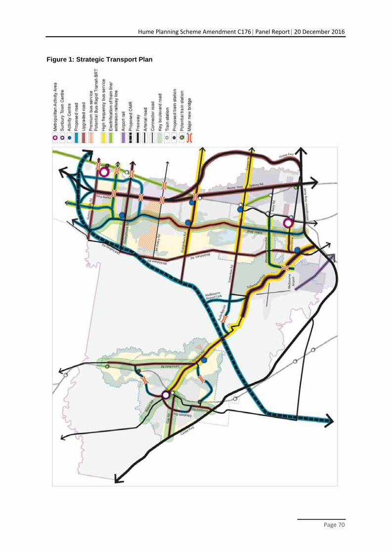
Hume Planning Scheme Amendment C176 Panel Report 20 December 2016
Page 70
Figure 1: Strategic Transport Plan
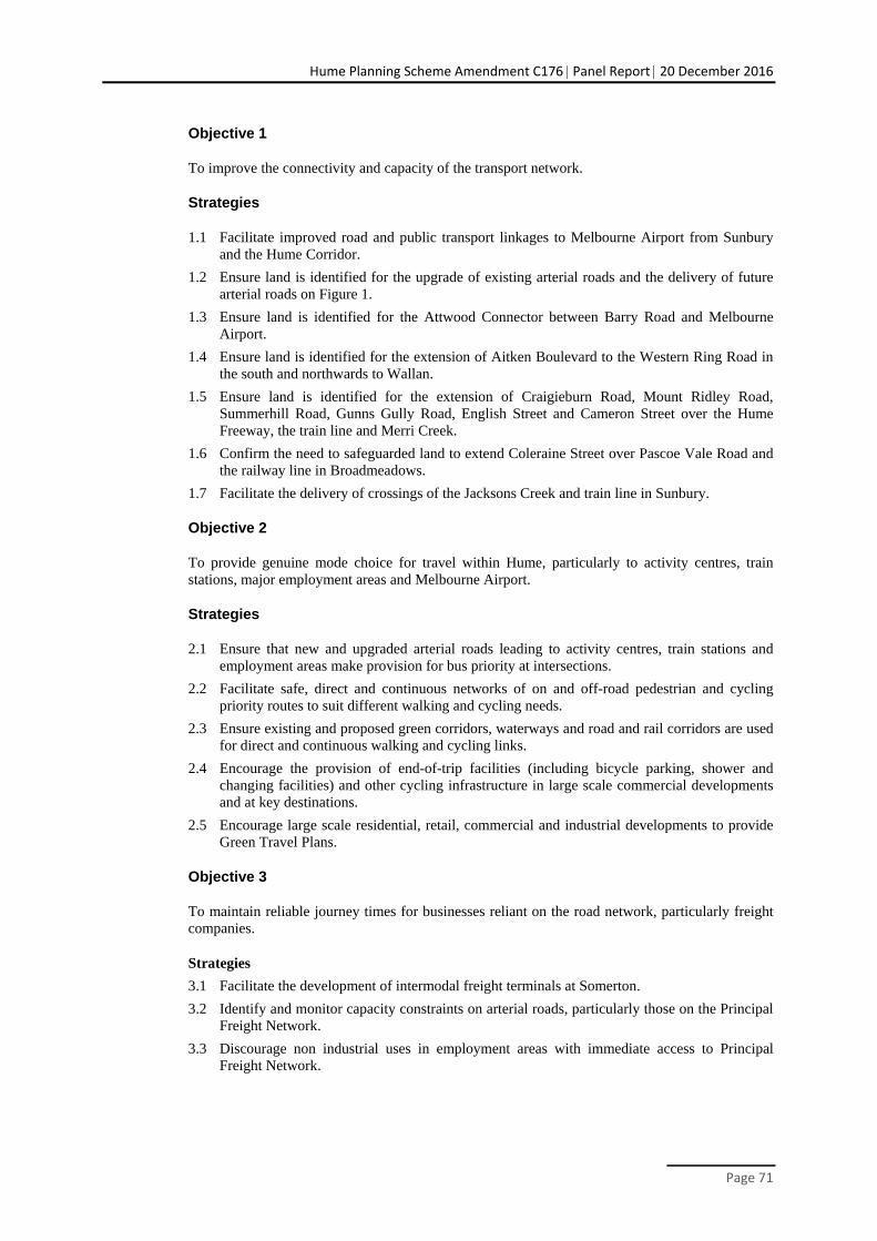
Hume Planning Scheme Amendment C176 Panel Report 20 December 2016
Page 71
Objective 1
To improve the connectivity and capacity of the transport network.
Strategies
1.1 Facilitate improved road and public transport linkages to Melbourne Airport from Sunbury and the Hume Corridor.
1.2 Ensure land is identified for the upgrade of existing arterial roads and the delivery of future arterial roads on Figure 1.
1.3 Ensure land is identified for the Attwood Connector between Barry Road and Melbourne Airport.
1.4 Ensure land is identified for the extension of Aitken Boulevard to the Western Ring Road in the south and northwards to Wallan.
1.5 Ensure land is identified for the extension of Craigieburn Road, Mount Ridley Road, Summerhill Road, Gunns Gully Road, English Street and Cameron Street over the Hume Freeway, the train line and Merri Creek.
1.6 Confirm the need to safeguarded land to extend Coleraine Street over Pascoe Vale Road and the railway line in Broadmeadows.
1.7 Facilitate the delivery of crossings of the Jacksons Creek and train line in Sunbury.
Objective 2
To provide genuine mode choice for travel within Hume, particularly to activity centres, train stations, major employment areas and Melbourne Airport.
Strategies
2.1 Ensure that new and upgraded arterial roads leading to activity centres, train stations and employment areas make provision for bus priority at intersections.
2.2 Facilitate safe, direct and continuous networks of on and off-road pedestrian and cycling priority routes to suit different walking and cycling needs.
2.3 Ensure existing and proposed green corridors, waterways and road and rail corridors are used for direct and continuous walking and cycling links.
2.4 Encourage the provision of end-of-trip facilities (including bicycle parking, shower and changing facilities) and other cycling infrastructure in large scale commercial developments and at key destinations.
2.5 Encourage large scale residential, retail, commercial and industrial developments to provide Green Travel Plans.
Objective 3
To maintain reliable journey times for businesses reliant on the road network, particularly freight companies.
Strategies
3.1 Facilitate the development of intermodal freight terminals at Somerton.
3.2 Identify and monitor capacity constraints on arterial roads, particularly those on the Principal Freight Network.
3.3 Discourage non industrial uses in employment areas with immediate access to Principal Freight Network.

Hume Planning Scheme Amendment C176 Panel Report 20 December 2016
Page 72
Objective 4
To design high quality, well-connected neighbourhoods which promote sustainable modes of transport.
Strategies
4.1 Ensure the design of subdivisions provides a permeable and legible street network which allows safe and direct pedestrian and cycle access to local destinations and the major road network.
4.2 Ensure street layouts in new development areas connect into the existing movement network, including walking, cycling and public transport networks.
4.3 Ensure that gaps in the walking and cycling network are addressed in development applications to achieve a continuous network.
4.4 Ensure walking and cycling path networks incorporate shade, seating and directional signage, and provide safe access to activity centres, community and educational facilities, and open spaces.
4.5 Ensure pedestrian crossings are located along roads with heavy traffic volumes and at key destinations such as activity centres, schools and community facilities.
4.6 Ensure that crossing points are provided where the bicycle network crosses major roads.
4.7 Discourage areas of car parking that interrupt primary pedestrian and cyclist routes.
4.8 Ensure that all connector roads are “bus ready” prior to service commitments, and have high quality pedestrian access to stops.
4.9 Ensure public transport stops are located at the primary pedestrian activity points and close to key building entries.
Policy guidelines
When deciding on an application for use, development or subdivision the following local policies will be considered, as appropriate:
Require transport and traffic impact assessments for all large scale developments.
Further work
Work with VicRoads to prepare functional layout plans for all arterial roads.
Identify opportunities to improve transport connectivity in new structure plans and place frameworks, and through large scale redevelopments.
Other actions
Advocate for timely upgrades to the arterial road infrastructure within Hume in Figure 1.
Advocate for the timely extension of the Upfield Train Line to Roxburgh Park, the electrified train services to Lockerbie in the Hume Corridor and the Lancefield Road north area of Sunbury.
Advocate for the timely provision of new stations at Lockerbie, Sunbury South and Sunbury North.
Advocate for the timely delivery of the Melbourne Airport Rail Link.
Ensure that travel time benefits to businesses, and productivity and economic benefits to the Hume and Melbourne economy are recognised in the prioritisation of funding and preparation of business cases for upgrades to the transport network.
Explore the potential for a new train station at Campbellfield.
Hume Planning Scheme Amendment C176 Panel Report 20 December 2016
Page 73
Plan and advocate for extensions to Hume’s Principal Public Transport Network to enable good accessibility to direct, frequent and reliable bus services.
Advocate for timely extensions to the Metropolitan Trail Network and Principle Bicycle Network within Hume.
Advocate for improved frequency, directness and reliability of bus services within Hume, particularly those leading to Melbourne Airport, activity centres and train stations.
Advocate for better timetable integration between bus and train services.
Advocate for bike parking infrastructure at train stations and other public transport interchanges.
21.07-2 Integrated Land Use and Transport
The integration of land use and transport provides opportunities to create sustainable and well-connected communities with a broad range of genuine travel mode choices. Concentrating high trip generating uses, employment opportunities, community uses and an increasing proportion of new housing close to activity centres and public transport corridors provides the greatest potential to reduce reliance on the private vehicle.
The planning of the growth areas in Hume provides opportunities to achieve this land use and transport integration at the outset of new developments. Equally, the intensification of established areas and the upgrade of transport infrastructure offer significant opportunities to achieve this integration and higher density development within established areas.
The quality of the transport infrastructure is vital to providing the amenity and level of access required to attract and support higher density and diverse land uses. It is also vital to the take up of sustainable modes.
Key issues
Increasing the number of public transport corridors capable of supporting higher density development and activity.
Improving the amenity around activity centres, along public transport corridors and around train stations to support and enable more intense development.
Improving the amenity and quality of the walking and cycling infrastructure within and leading to activity centres and train stations to support less car dependent development.
Ensuring that the design of roads, parking and walking and cycling infrastructure in activity centres supports an integration of land uses.
Objective 5
To increase the number of transport corridors capable of supporting higher density development and increased integration of land uses.
Strategies
5.1 Ensure Aitken Boulevard and Craigieburn Road are designed to support high frequency buses, walking and cycling and have high quality landscaping amenity.
5.2 Ensure new connector roads are designed with bus priority at intersections with arterial roads, high quality walking and cycling infrastructure, and good landscaping and amenity to support higher density development over time.
5.3 Identify and review opportunities to improve the bus priority infrastructure, walking and cycling infrastructure, landscaping and amenity along arterial and connector roads with high frequency bus routes.
xx/xx/20xx Proposed C176
Hume Planning Scheme Amendment C176 Panel Report 20 December 2016
Page 74
Objective 6
To ensure that the design of the transport infrastructure within and around activity centres and train stations supports and facilitates higher density development and activity.
Strategies
6.1 Encourage streetscape improvements that make existing activity centres more attractive and improve their function and viability.
6.2 Facilitate new activity centres in the locations shown in Figure 1 and discourage new activity centres on arterial roads.
6.3 Encourage the ‘main street’ of new activity centres to be perpendicular to roads anticipated to experience high levels of through traffic.
6.4 Facilitate new activity centres with streets and parking arrangements capable of supporting development above ground floor uses, particularly residential and commercial development.
6.5 Ensure that roads within and leading to new activity centres and new train stations are direct and have high quality landscaping and walking and cycling infrastructure.
6.6 Ensure activated frontages are provided on the primary pedestrian and bicycle routes to and within activity centres.
Further work
Work with VicRoads to prepare functional layout plans for Craigieburn Road and Aitken Boulevard.
Identify opportunities to improve transport infrastructure and amenity in existing areas in new structure plans and place frameworks, and through large scale redevelopments.
Other actions
Advocate for delivery of high quality landscaping along all arterial roads in Hume, particularly around activity centres and train stations.
Work with Vic Roads to ensure that the design of Macedon Street retains its historic qualities and supports the potential for redevelopment.
21.07-3 Parking
Streets provide for a diverse range of road users, including for vehicles to drive along and to park. Effective planning, management and design of parking are critical to achieving high levels of amenity, good accessibility and long term sustainability.
The benefits of car parking are that it facilitates easy access by car to residential, recreational and business activities, and to public transport. Provision of sufficient parking provides an economic benefit to businesses. However, the costs of car parking, including occupying large amounts of high value land, has the potential to generate demand for car travel causing congestion impacting on the environment and reducing local amenity. Given the costs and benefits of parking, it is desirable to optimise the amount and management of parking in order to provide ‘just enough’, and flexibility to provide for changing requirements over time.
The demand for car parking varies between different land uses, and is dependent on the location of the use and the convenience and level of service of other transport modes. In areas with good public transport, or convenient walking and cycling access, the demand for car parking will be lower, therefore it is critical to locate development in areas where it will have a lower demand for access by private car, such as at activity centres that are well served by public transport.
xx/xx/20xx Proposed C176
Hume Planning Scheme Amendment C176 Panel Report 20 December 2016
Page 75
Key issues
Balancing the need and demand for car parking with the needs of other uses.
Encouraging the co-location and consolidation of parking.
Ensuring car parking does not impact on the amenity of activity centres or streets.
Objective 7
To plan, design and manage parking so that the supply of parking is optimised and makes a positive contribution to the public realm.
Strategies
7.1 Ensure the design of new activity centres identifies opportunities for development of car parking areas in response to increased sustainable travel.
7.2 Encourage the co-location of land uses which generate large parking demand, and the sharing of their parking requirements.
7.3 Encourage parking in activity centres to be located on the edge of the centre on appropriate access roads.
7.4 Ensure that parking incorporates environmentally sustainable design and development principles, including canopy tree cover and sustainable storm water management measures.
Policy guidelines
When deciding on an application for use, development or subdivision the following local policies will be considered, as appropriate:
Apply Council’s Parking Hierarchy to prioritise the needs of the various users across different areas to ensure that kerbside space is allocated in an appropriate, fair, consistent and transparent way across the city.
Require car parking plans for new and expanding activity centres and other major trip generating uses to balance demand for car parking with sustainable travel.
Other actions
Advocate for increased car parking at Craigieburn and Sunbury Train Stations.
21.07-4 Reference Documents
Healthy by Design: a planners’ guide to environments for active living, National Heart Foundation of Australia, 2004
Hume Bicycle Network Plan, Hume City Council, 2015
Hume Corridor HIGAP Spatial Strategy and Delivery Strategy, Hume City Council, 2015
Hume Integrated Land Use and Transport Strategy 2011-2020, Hume City Council, 2011
Hume Parking Management Policy 2015, Hume City Council, 2015
Melbourne Airport Master Plan, Australia Pacific Airports Melbourne, 2013
Sunbury HIGAP Spatial Strategy and Delivery Strategy, Hume City Council, 2012
Walking and Cycling Strategy 2010-2015, Hume City Council, 2010
xx/xx/20xx Proposed C176
Hume Planning Scheme Amendment C176 Panel Report 20 December 2016
Page 76
21.08 NATURAL ENVIRONMENT AND ENVIRONMENTAL RISK
21.08-1 Natural Heritage
Hume supports a rich natural heritage which contributes to the municipality’s character and provides the community with a range of social, economic, ecological and health benefits. Hume’s landscape is characterised by undulating basalt plains punctuated by volcanic hilltops and deep incised valleys and waterways.
Hume’s remnant vegetation is amongst the most endangered in Victoria. This vegetation exists as scattered trees, woodlands, grasslands, scrub-lands and riparian vegetation. Hume’s remnant landscape continues to support both common and threatened native plants and animals.
Sites of particular note include Organ Pipes National Park, Woodlands Historic Park, Cooper Street Grassland, Evans Street Wildflower Grassland Reserve, Kalkallo Commons Grasslands, Mt. Ridley Nature Reserve and the waterways of Deep, Emu, Jacksons, Merri and Moonee Ponds Creeks and their associated tributaries.
Improving public access to a greater number and diversity of natural landscapes has the potential to improve the overall health and wellbeing of Hume’s community and increase their understanding of its natural heritage values.
The Melbourne Strategic Assessment (MSA) is the Victorian Government’s approach to managing the impact of urban development in Melbourne’s growth areas on significant vegetation communities, plants and animals. The Melbourne Strategic Assessment program is endorsed by the Commonwealth Government under the federal Environment Protection and Biodiversity Conservation Act 1999. It streamlines the development process in Melbourne’s growth corridors by assessing the impacts of development on certain native plant and animal species in a consolidated process, rather than property by property. The MSA takes the cumulative effects of development on the environment into account, and sets out actions to address the impacts, giving better protection for species in strategically located conservation areas and reserves.
Within Hume three precinct areas are subject to Native Vegetation Precinct Plans which directly enact the requirements of the MSA – Greenvale North (R1), Craigieburn (R2) and Greenvale West (R3).
Outside of these precincts the Biodiversity Conservation Strategy 2013 is the primary strategic framework which enacts the MSA. In the Hume growth areas 12 Conservation Areas are identified for retention including the Mt Ridley Woodland, Kalkallo Creek, Merri Creek, Jacksons Creek and Emu Creek.
Key issues
Incremental loss of native vegetation through urban and rural development.
Protecting and restoring biodiversity, natural habitats and ecological linkages.
Increasing community and public access to natural landscapes.
Objective 1
To protect, conserve and enhance natural heritage for biodiversity, amenity and landscape character purposes.
Strategies
1.1 Ensure development seeks to preserves the diversity and long term security of terrestrial and aquatic species and their environments.
1.2 Ensure development seeks to retain native vegetation, including scattered indigenous trees.
1.3 Conserve and re-establish areas of natural habitat where appropriate.
xx/xx/20xx Proposed C176
xx/xx/20xx Proposed C176
Hume Planning Scheme Amendment C176 Panel Report 20 December 2016
Page 77
1.4 Protect and enhance existing habitat and open space corridors, including waterways, with significant landscape and/or flora and fauna values.
1.5 Ensure development and the planning of new areas connects areas of native vegetation identified for protection with the wider landscape and open space network.
1.6 Ensure conservation assets in existing and future urban areas are well integrated with the built environment and incorporate opportunities for the public to access and enjoy these spaces.
1.7 Ensure new areas contribute towards an increase in tree canopy cover throughout the landscape.
1.8 Encourage the use of indigenous species in landscaping and planting work.
Decision guidelines – native vegetation decision criteria
Council will consider the following criteria (as appropriate) when assessing proposals which involve the removal or retention of native vegetation:
The Melbourne Strategic Impact Assessment, including the Biodiversity Conservation Strategy, any approved native vegetation precinct plan and any other State approved biodiversity policy.
The context of the site and its surrounds with regard to the network of existing and future reserves.
The presence of indigenous and non-indigenous cultural heritage values.
The capacity to maintain the ongoing viability of the populations of flora and fauna species and vegetation communities and the role of the site in providing habitat connectivity.
The capacity to manage bushfire, grassfire and public safety risks.
The capacity of the land to support the proposed activity including slope, land subsidence potential and protection of water quality including the role of native vegetation in preventing soil erosion or landslip.
Further strategic work
Prepare a Precinct Structure Plan for Craigieburn West that protects the areas of woodland identified in the Biodiversity Conservation Strategy along with other scattered trees and remnant patches of local significance, and integrates and connects them as part of the wider open space network in the Mickleham and Craigieburn precincts.
Prepare a Precinct Structure Plan for the western end of the Inter Urban Break that protects the biodiversity values, including scattered trees, across the site in conservation and open space areas, and connects them into the wider open space network in the Mickleham and Craigieburn precincts.
Prepare a structure plan for Kalkallo Township that protects the Kalkallo Commons, the Kalkallo Creek and the Kalkallo Cemetery with the provision of appropriate public access.
Prepare structure plans for the Sunbury area that protect Jacksons Creek and Emu Creek and their tributaries and escarpments and integrates “nature conservation” and “open space” areas identified in the Biodiversity Conservation Strategy with the wider open space network.
Review the planning controls of identified sites of environmental and landscape value to update existing overlays and apply new zones and overlays where relevant.
Prepare a non-urban HIGAP spatial and delivery strategy to guide the planning of Hume’s rural areas, including the application of overlays to protect sites and areas of environmental and landscape significance and identify areas at risk of significant erosion.
Hume Planning Scheme Amendment C176 Panel Report 20 December 2016
Page 78
21.08-2 Environmental Land Management
Significant change has occurred to the natural landscape, including land clearance, habitat degradation and the introduction of invasive species. Other threats to land health in Hume include invasive plants and animals, soil degradation, and climate change.
Areas of the municipality, particularly around Sunbury are highly susceptible to soil erosion due to the steep landforms and fragile soil types. Risk of erosion may be increased in these areas through inappropriate land management and development.
Key issues
Reducing the amount of earthworks required by land development.
Managing the effects of large scale earthworks on rural land.
Minimising the visual and amenity impacts associated with large scale fill in inappropriate locations.
Ensuring that land uses do not compromise the long term sustainability of soils and waterways.
Objective 2
To improve the land health of the natural environment.
Strategies
2.1 Ensure development avoids, minimises or mitigates the impacts of erosion.
2.2 Encourage the appropriate use of protective measures for erosion including geotechnical recommendations, storm water flow and volume measures, and the appropriate use of construction materials, landscaping, watering systems and impervious surfaces.
2.3 Ensure development is sited and designed to avoid the expansion of areas affected by erosion or the creation of new erosion affected areas.
2.4 Discourage and restrict development on soils with extreme erosion capacity.
2.5 Encourage the retention of vegetation on erosion prone soils.
2.6 Ensure development works avoid, minimise and mitigate the generation of fill.
2.7 Encourage development that requires earthworks to create a balance between cut and fill and to minimise the amount of fill taken off site.
2.8 Ensure recipient sites for large scale fill deliver improvements to the land which generates a net improvement to the natural landscape.
2.9 Ensure that the placement of fill on rural land is controlled through an Environmental Management Plan.
2.10 Ensure that potentially contaminated land is identified, and appropriately managed and remediated to a standard suitable for the intended use or development.
Decision guidelines
Where appropriate ensure development proposals prepare a Conservation, Vegetation or Environmental Management Plan for the management of remnant vegetation, faunal habitat and geological features to be retained, and areas requiring restoration or revegetation.
Where appropriate ensure development proposals prepare a Construction Environmental Management Plan that provides measures to mitigate the impact of development on the environment.
xx/xx20xx Proposed C176
Hume Planning Scheme Amendment C176 Panel Report 20 December 2016
Page 79
Further strategic work
Investigate sites of known or potential contamination to apply the Environmental Audit Overlay.
21.08-3 Water Quality and Conservation
Hume is located within the Port Phillip and Western Port Catchment region, and falls within both the Maribyrnong and Yarra River catchments. Significant waterways include Deep, Emu, Blind, Kismet, Jacksons, Merri, Merlynston, Aitken, Malcolm, Yuroke and Moonee Ponds Creeks. Hume’s waterways provide habitat corridors, support a variety of flora and fauna species, and also contain cultural heritage values and a range of environmental services.
Land use and development within the municipality significantly influences local waterways and the overall health of both the Yarra and Maribyrnong catchments. The intensification of urban development will inevitably result in the increased discharge of water in local waterways. There is a need to ensure that the quality and quantity of this discharge is controlled through development design and mitigation measures.
Key issues
Protecting and improving the water quality of Hume’s waterways.
Objective 3
To protect water quality and ensure that water resources are managed in a sustainable way.
Strategies
3.1 Encourage development to be designed to minimise wastewater and stormwater discharge and maximise reuse.
3.2 Ensure land use and development proposals identify and consider their impact on surrounding waterways and have the capacity to manage storm water onsite.
3.3 Ensure that development within the Greenvale Reservoir catchment area is compatible with the protection of the reservoir and provides for the integration of protection measures.
3.4 Ensure industrial and commercial land uses incorporate stormwater treatment measures into the design of development.
3.5 Ensure the siting, design, operation and rehabilitation of landfills minimises impacts on groundwater and surface water.
Policy guidelines
When deciding on an application for use, development or subdivision the following local policies will be considered, as appropriate:
Clause 22.19 Industrial Stormwater Management.
Other actions
Work with Melbourne Water and Yarra Valley Water to deliver recycled water to new development areas and to reduce the volume of stormwater entering waterways.
To work with Melbourne Water to assist with the preparation of drainage master plans (Development Services Schemes) for new development areas.
xx/xx20xx Proposed C176
Hume Planning Scheme Amendment C176 Panel Report 20 December 2016
Page 80
21.08-4 Bushfire and flood risks
The municipality encompasses areas of significant bushfire (grassfire) risk. It has been impacted by bushfire in the recent past and the risks persist today.
Key issues
Minimising bushfire and flood risks to urban areas.
Objective 4
To minimise the risk to life, property and the environment from flood and bushfire.
Strategies
4.1 Ensure that subdivisions are appropriately designed to mitigate flood and bushfire risk.
4.2 Ensure that development is appropriately sited to provide protection from flood and bushfire.
4.3 Encourage planning decisions to prioritise protection of human life and adopt a precautionary approach.
4.4 Consider the following principles for development in areas at risk of bushfire:
direct development to locations of lower bushfire risk and away from areas of high bushfire risk
avoid development in areas of extreme bushfire risk
avoid development in areas where planned bushfire protection measures may be incompatible with other environmental objectives.
21.08-4 Reference documents
Hume Biodiversity Planning Policy, Hume City Council, 2016
Hume Corridor HIGAP Spatial Strategy and Delivery Strategy, Hume City Council, 2015
Hume Open Space Strategy 2010-2015, Hume City Council, 2010
Industrial Stormwater Code of Practice, Hume City Council, 2008
Sunbury HIGAP Spatial Strategy and Delivery Strategy, Hume City Council, 2012
Hume Land and Biodiversity Plan 2015-2019, 2015
xx/xx20xx Proposed C176