Embed Size (px)
Citation preview

Planning and Prioritisation of Rural Roads in Bangladesh
Inception Report
Department of Urban and Regional Planning (DURP). Bangladesh University of Engineering and Technology (BUET)
BAN2072A
July 2016
Planning and Prioritisation of Rural Roads in Bangladesh
Page 2
The views in this document are those of the authors and they do
not necessarily reflect the views of the Research for Community
Access Partnership (ReCAP), Department of Urban and Regional Planning (DURP), Bangladesh University of Engineering and
Technology (BUET).
Cover Photo:
Mr. Md. Mashrur Rahman using LGED’s GIS Database
Quality assurance and review table
Version Author(s) Reviewer(s) Date
ReCAPProject Management Unit Cardno Emerging Market (UK) Ltd Oxford House, Oxford Road Thame OX9 2AH United Kingdom

Planning and Prioritisation of Rural Roads in Bangladesh
Page 3
ReCAPInception Report Template
ReCAP Database Details: Planning and Prioritisation of Rural Roads in Bangladesh
Reference No: BAN2072A Location Bangladesh
Source of Proposal Peer contact Procurement Method Limited Tender
Theme Sub-Theme
Lead Implementation
Organization
Department of Urban & Regional Planning (URP), Bangladesh University of Engineering &
Technology (BUET)
Partner Organization
Local Government Engineering Department (LGED)
Total Approved
Budget
GBP 120,000.00 (approved)
GBP 133,800.00 (proposed budget
including additional task)
Total Used Budget
GBP 0.00
Start Date 7th April, 2016
End Date 6th April, 2017 (Original)
21st June, 2017 (Proposed)
Report Due Date 20th July, 2016 Date Received

Planning and Prioritisation of Rural Roads in Bangladesh
Page 4
Abstract
Bangladesh has 342,764 km roads of different categories according to LGED Database, 2016. The Local Government Engineering Department (LGED) manages all rural roads (Upazila, Union and Village roads) which form more than 93% of total roads or about 321,462 km of roads. In the course of time, many of these roads are being used more intensively by heavier vehicles than estimated during their design and construction. Substantial growth in traffic volume and change in their composition have led to rapid deterioration of the road infrastructure. Although LGED spends a considerable amount of resources for the improvement of rural roads, the selection of roads from a large number of candidate roads is not undertaken through a rational selection process. For the effective utilization of available resources, this project aims to develop a prioritisation methodology for the development, upgradation and maintenance of the rural roads. To implement the methodology, a software would be developed which would provide a prioritised list of rural roads based on analysis of updated socio-economic and environmental data. This will eventually help LGED to make objective decision with effective budget allocation through an automated system. The project includes developing a software manual and a training program for the LGED officials to help them understand and use the software.
Key words
Rural Road, Bangladesh, Prioritisation, Multi Criteria Analysis, Cost Benefit Analysis, Vehicle Operating Cost Savings, Travel Time Savings, Annual Average Daily Traffic
RESEACH FOR COMMUNITY ACCESS PARTNERSHIP (ReCAP)
Safe and sustainable transport for rural communities
ReCAP is a research programme, funded by UK Aid, with the aim of promoting safe and sustainable transport for rural communities in Africa and Asia. ReCAP comprises the Africa Community Access Partnership (AfCAP) and the Asia Community Access Partnership (AsCAP). These partnerships support knowledge sharing between participating countries in order to enhance the
uptake of low cost, proven solutions for rural access that maximise the use of local resources. The ReCAP programme is managed by Cardno Emerging
Markets (UK) Ltd.
See www.research4cap.org

Planning and Prioritisation of Rural Roads in Bangladesh
Page 5
Acknowledgements
The project team are indebted to the Department of Urban and Regional Planning (DURP) of Bangladesh University of Engineering and Technology (BUET) for providing necessary logistic supports. We are grateful to the LGED and other government officials of the study area for access to their data and relevant literatures. We also acknowledge ReCAP for their constant support and assistance.

Planning and Prioritisation of Rural Roads in Bangladesh
Page 6
Acronyms, Units and Currencies
AADT Annual Average Daily Traffic
APS Agricultural Product Surplus BDT Bangladeshi Taka BRTC Bureau of Research Testing and Consultancy (at BUET)
BUET Bangladesh University of Engineering and Technology CBA Cost Benefit Analysis CVD Commercial Vehicles per Day DURP Department of Urban and Regional Planning
EIRR Economic Internal Rate of Return FRB Feeder Road Type B GBP Great British Pound GIS Geographical Information System
HDM Highway Design and Maintenance Model LGED Local Government and Engineering Department NH National Highway
NMT Non-motorized Transport NPV Net Present Value ReCAP Research for Community Access Partnership RED Roads Economic Decision Model
RHD Roads and Highways Department RR1 Rural Road Type 1 SFYP Seventh Five Year Plan
TTCS Travel Time Cost Saving UCS User Cost Saving VOCS Vehicle Operating Cost Saving VPD Vehicles Per Day
Planning and Prioritisation of Rural Roads in Bangladesh
Page 7
Contents ReCAPInception Report Template 3 Abstract 4 Key words 4 Acknowledgements 5 Acronyms, Units and Currencies 6
1 Executive Summary .................................................................................................. 9 2 Introduction ............................................................................................................10
2.1 Location 10 2.2 Names of Implementing Agency and Delivery Organisation 15 2.3 Key Dates 15 2.4 Approved Cost of the Initiative 15
3 Background .............................................................................................................15 3.1 Context and Objectives of the Study 15 3.2 Problem Analysis 18 3.3 Literature Review 19
3.3.1 Introduction 19 3.3.2 Multi Criteria Analysis (MCA) 19 3.3.3 Economic Analysis (Cost Benefit Analysis) 20 3.3.4 Participatory Approaches 21 3.3.5 Network Planning Models based on Optimization Techniques 22 3.3.6 Hybrid Methodologies – Combination of Multiple Methodologies on Road Planning 22 3.3.7 Prioritisation of rural roads by LGED: Current Practice 23
3.4 Choice of Methodology for the Present Study 25 3.4.1 Village Roads 25 3.4.2 Upazila and Union Roads 26
3.5 Scope of Work 26 4 Approach and Methodology.....................................................................................28
4.1 Research Objective 28 4.2 Links to ReCAP Logframe 28 4.3 Given Conditions, Important Considerations and Assumptions 28
4.3.1 Selection of Criteria for Prioritisation of Rural Roads 29 4.4 Methodology for Prioritisation of Upazila and Union Roads 30
4.4.1 Identifying a Basic Upazila and Union Road Network 30 4.4.2 Determination of the Importance of the Activity Centres 30 4.4.3 Determination of the Interaction Index of Roads 31 4.4.4 Determination of the Current and Future Traffic Volumes of Upazila and Union Roads 31 4.4.5 Estimation of EIRR for Upazila and Union roads 31 4.4.6 Estimation of other benefits 32 4.4.7 Development of an MCA scoring and weighting framework incorporating CBA results 32
4.5 Methodology for Prioritisation of Village roads 32 4.5.1 Identification of a Basic Village Road Network 32 4.5.2 Selection of factors for Multi-Criteria Analysis (MCA) 32 4.5.3 Development of an MCA Scoring and Weighting Framework for Village Roads 33
5 Inception Phase .......................................................................................................35 5.1 Meetings with LGED and ReCAP Officials 35 5.2 Field Visit 40
5.2.1 Details of the Field Visit 40 5.3 Inception Report Presentation Meeting at LGED 42

Planning and Prioritisation of Rural Roads in Bangladesh
Page 8
6 Revised Workplan....................................................................................................45 7 Management Approach ...........................................................................................46 8 Technical Inputs and Budget and Inputs ...................................................................47 9 Community Access...................................................................................................48 10 M&E Plan ................................................................................................................49 11 Risks........................................................................................................................50 Annex A: Updated Workplan ...........................................................................................51 Annex B: Contribution to ReCAP Log Frame .....................................................................52 Outcome 1 ......................................................................................................................56 Outcome 2 ......................................................................................................................57 Outcome 3 ......................................................................................................................57 Output 1: Research and Uptake .......................................................................................57
Output 1.1 57 Output 1.2 57 Output 1.3 58 Output 1.4 58 Output 1.5 Not applicable to Service Providers. 58 Output 1.6 58
Output 2: Capacity Building .............................................................................................58 Output 2.1 58 Output 2.2 Not relevant to Service Providers. 59 Output 2.3 59
Output 3: Knowledge ......................................................................................................59 Output 3.1 Not relevant to Service Providers 59 Output 3.2 59 Output 3.3 59
Annex C: Logframe Matrix Developed by BUET Team Based on the Objectives of the Project ............................................................................................................................60 Annex D: Risk Matrix.......................................................................................................63 Annex E: References........................................................................................................65 Annex F: Technical Inputs ................................................................................................68 Annex G: Revised Budget ................................................................................................69 Annex H: Observations in the meetings and response of the BUET team (19th May, 2016) .70 Annex I: Observations in the meetings and response of the BUET team (14th June, 2016) ..71 Annex J: Survey Instrument (Sample AHP Questionnaire).................................................72

Planning and Prioritisation of Rural Roads in Bangladesh
Page 9
1 Executive Summary
Research for Community Access Partnership (ReCAP) is a six-year programme with an overall aim to promote safe and sustainable rural access in Asia and Africa. Bangladesh’s Local Government Engineering Department (LGED) has been an active participant in the programme. As part of the programme Department of Urban and Regional Planning (URP) at Bangladesh University of Engineering and Technology (BUET), Dhaka is conducting the project- “Planning and Prioritisation of Rural Roads in Bangladesh” (Project reference: BAN2072A). The objectives of the project are developing a methodology and a computer based software or tool for prioritisation of LGED managed roads and providing training to the concerned LGED users and officials. LGED managed rural roads are Upazila, Union and Village roads. Traffic and functional characteristics of Upazila and Union roads are different from the Village roads. Therefore, two separate prioritisation methodologies have been proposed for the appraisal of rural roads – one for the Upazila and Union roads and a second one for Village roads. For Upazila and Union roads, first of all, the basic road network will be defined consi sting of all the designated Upazila and Union roads. Traffic volume is an important criterion for determining the priority of any road development project. However, traffic volume data may not be readily available for all of the roads. In such cases, traffic volume will be estimated by using a regression model. The expansion factor method will be used to estimate future traffic volume of roads. The estimated future traffic volumes may give an indication of priority of the Upazila and Union roads. However, for a better assessment of the cost and benefit of road upgrading, EIRR will be calculated. In order to make a more complete assessment (especially for rural roads), the benefits from the social or environmental criteria also need to be assessed. A few simple criteria will be used to estimate such benefits. Finally, a simple MCA scoring and weighting framework is proposed to combine the results of CBA and social and environmental benefits (or costs) from improved access. The priority order for the development of Upazila and Union roads will be determined on the basis of their overall combined scores. For the Village roads, an initial list of potential criterion for an MCA (multi-criteria analysis) involving economic, social and environmental factors will be identified considering LGED’s current practice, views of experts and literature search. The final selection of evaluation criteria and their relative weights will be determined by applying the Analytic Hierarchy Process (AHP) technique based on the outcome of an opinion survey among policy makers, experts, rural people and other stakeholders. Finally, an MCA Scoring and Weighting Framework will be developed for Village Roads. Inception Report (IR) is the first of the deliverables of the project as per ToR. After project initiation, the project team members had a Kick-off meeting with ReCAP and LGED counterparts and several other meetings with stakeholders subsequently. Preliminary field visit at the study area, Tangail district, has also been made. All these interactions have been very helpful for clarification of some of the issues and provided useful insights for preparing the IR. In this Inception Report the detailed methodology is presented and the challenges in reaching the project objectives are identified. It is expected that the final selection of methodology and tool will be done upon feedback from LGED, ReCAP and other stakeholders involved. It is expected that the outcomes of the research project will enhance the decision making capacity in LGED regarding selection of rural roads for improvement and upgrading and thus ensure proper utilization of public money for socio-economic benefits of the people.

Planning and Prioritisation of Rural Roads in Bangladesh
Page 10
2 Introduction
2.1 Location
Tangail is selected as the study area for the project. It is 13th largest district of Bangladesh by area and fifth largest by population. It is the largest district of Dhaka division by area and second largest by population following Dhaka district. It lies between 24° 01′ and 24° 47′ north latitudes and between 89° 44′ and 90° 18′ east longitudes. Figure 2.1 shows the administrative units and several important features of the district.
Figure 2.1: Map of Tangail District
Source: LGED, 2016

Planning and Prioritisation of Rural Roads in Bangladesh
Page 11
This district is surrounded by Jamalpur district on the north, Dhaka and Manikganj districts on the south, Mymensingh and Gazipur on the east, and the Jamuna River on the west (Figure 2.1). The city of Tangail is located around 86 km North West of Dhaka. The district is crisscrossed by roads. National Highway 4 (NH 4), which connects Dhaka with North-west Bangladesh through Jamuna Bridge passes through this district. According to Census 2011, the population of the district was 3,605,083 of which 3,047,613 live in rural area. There are 12 Upazilas (sub-districts) and nine paurashavas (municipalities) within the district. Ghatail is the largest Upazila in terms of area and Tangail Sadar is the largest Upazila in terms of population size. Table 2.1 provides some of the salient geographic and demographic information of Tangail district.
Table 2.1: An Overview of Tangail District
Area (sq
km)
Upa-zila
Paurashavas
Union Mouza* Village Population (2011) Densit
y (per sq km)
Literacy rate (%)
Male Female M* F*
3,413.68
12 9 110 1,884 2,443 3,605,083
1,056 46.8
1,757,370 1,847,713 50 44
*Mouza: Smallest Geographic Unit for Revenue Collection
*M: Male, *F: Female
Source: BBS, 2015
There are several growth centres, markets (locally known as hat or bazaar) and other activity centres within the district. Table 2.2 shows the numbers of these market centres and other activities in the Tangail district.
Table 2.2: Number of Growth Centres, Educational and Other Facilities in Tangail District
Facilities Number Facilities Number
Growth centre 77 Homeopathy college 1
Market 457 Madrasas* 202
Government primary schools 941 Technical university 1
Non-government primary schools 395 Nursing institutes 2
Community primary schools 146 Polytechnic institute 1
NGO operated schools 1,304 Medical assistant training school 1
Junior schools 40 Police academy 1
Satell ite schools 86 Teachers' training school 1
Government high schools 5 Mosque 5,763
Non-government high schools 341 Temple 759
Government colleges 5 Church 56
Non-government colleges 48 Fuel Fil l ing station 44
University colleges 3 Fire station 2
Textile engineering colleges 2 Police station 23
Medical college 1 Cyber cafe 9
Law college 1 Flood and Cyclone Shelter 18
*Madrasa: An educational institution for the study of Islamic Theology and Religious Law
Source: BBS, 2012; BBS 2013
Planning and Prioritisation of Rural Roads in Bangladesh
Page 12
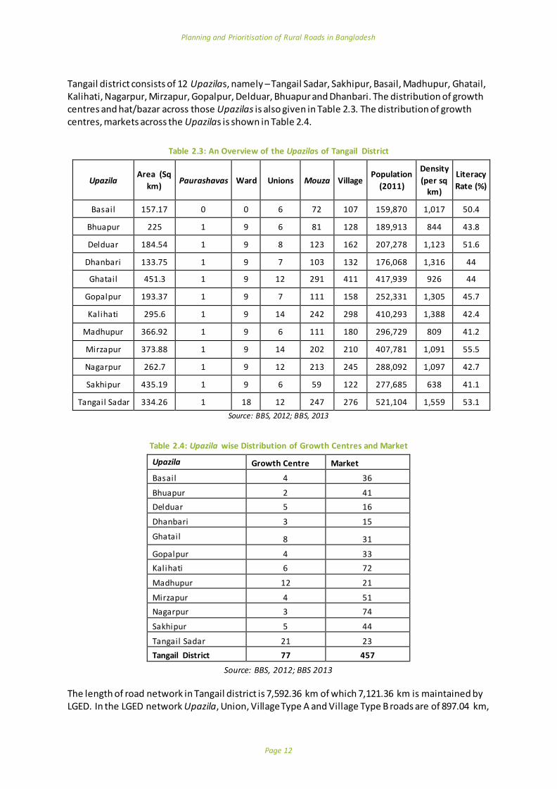
Tangail district consists of 12 Upazilas, namely – Tangail Sadar, Sakhipur, Basail, Madhupur, Ghatail, Kalihati, Nagarpur, Mirzapur, Gopalpur, Delduar, Bhuapur and Dhanbari. The distribution of growth centres and hat/bazar across those Upazilas is also given in Table 2.3. The distribution of growth centres, markets across the Upazilas is shown in Table 2.4.
Table 2.3: An Overview of the Upazilas of Tangail District
Upazila Area (Sq
km) Paurashavas Ward Unions Mouza Village
Population
(2011)
Density
(per sq km)
Literacy
Rate (%)
Basail 157.17 0 0 6 72 107 159,870 1,017 50.4
Bhuapur 225 1 9 6 81 128 189,913 844 43.8
Delduar 184.54 1 9 8 123 162 207,278 1,123 51.6
Dhanbari 133.75 1 9 7 103 132 176,068 1,316 44
Ghatail 451.3 1 9 12 291 411 417,939 926 44
Gopalpur 193.37 1 9 7 111 158 252,331 1,305 45.7
Kalihati 295.6 1 9 14 242 298 410,293 1,388 42.4
Madhupur 366.92 1 9 6 111 180 296,729 809 41.2
Mirzapur 373.88 1 9 14 202 210 407,781 1,091 55.5
Nagarpur 262.7 1 9 12 213 245 288,092 1,097 42.7
Sakhipur 435.19 1 9 6 59 122 277,685 638 41.1
Tangail Sadar 334.26 1 18 12 247 276 521,104 1,559 53.1
Source: BBS, 2012; BBS, 2013
Table 2.4: Upazila wise Distribution of Growth Centres and Market
Upazila Growth Centre Market
Basail 4 36
Bhuapur 2 41
Delduar 5 16
Dhanbari 3 15
Ghatail 8 31
Gopalpur 4 33
Kalihati 6 72
Madhupur 12 21
Mirzapur 4 51
Nagarpur 3 74
Sakhipur 5 44
Tangail Sadar 21 23
Tangail District 77 457
Source: BBS, 2012; BBS 2013 The length of road network in Tangail district is 7,592.36 km of which 7,121.36 km is maintained by LGED. In the LGED network Upazila, Union, Village Type A and Village Type B roads are of 897.04 km,

Planning and Prioritisation of Rural Roads in Bangladesh
Page 13
1,112.88 km, 2,868.08 km and 2,243.36 km respectively (LGED, 2016) (Table 3.1). The category and surface condition of the road network in different Upazilas is shown in Table 2.5.
Table 2.5: Category and Surface Condition of Road Network in different Upazila of Tangail District
Name of Upazila
Total (km)
Upazila (km) Union (km) Village Type A (km) Village Type B (km)
Earthen Paved Total Earthen Paved Total Earthen Paved Total Earthen Paved Total
Tangail Sadar
489.52
19.55 60.75 81.30 53.92 61.10 117.37 169.99 28.41 200.80 90.00 0.05 90.05
Mirzapur 957.9
0 27.09 61.36 91.45 80.21 33.28 121.44 239.68 31.74 283.15 437.17 18.29 461.86
Basail 407.4
8 30.69 32.23 62.92 65.29 30.61 95.90 99.88 14.81 114.69 131.28 2.69 133.97
Bhuapur 397.4
9 3.51 22.91 26.42 19.12 27.94 49.66 146.76 33.90 187.06 132.58 1.62 134.35
Delduar 378.9
7 26.07 36.76 64.93 60.19 17.21 79.66 163.34 11.91 177.50 56.03 0.85 56.88
Dhanbari 323.5
5 5.80 36.44 42.24 38.91 34.29 73.20 154.96 11.47 166.83 33.88 7.40 41.28
Ghatail 850.7
8 26.09 78.25 104.34 50.97 48.15 99.12 326.67 61.70 388.37 248.69 10.26 258.95
Gopalpur 529.2
8 0.90 48.93 51.63 7.13 38.13 45.26 124.70 49.80 177.38 232.01 16.97 255.01
Kalihati 671.9
3 36.88 81.96 124.27 68.57 45.59 117.38 257.97 37.62 296.59 130.00 3.69 133.69
Madhupur 718.0
2 0.57 52.79 53.36 46.39 50.09 98.43 248.18 46.20 300.48 254.75 8.67 265.75
Nagarpur 716.9
2 33.03 66.01 103.86 68.19 25.67 95.85 276.94 7.92 286.36 227.38 1.61 230.85
Shakhiopur 679.5
7 17.10 73.24 90.34 85.37 33.54 119.61 250.83 38.05 288.88 163.39 17.10 180.74
Source: LGED, 2016
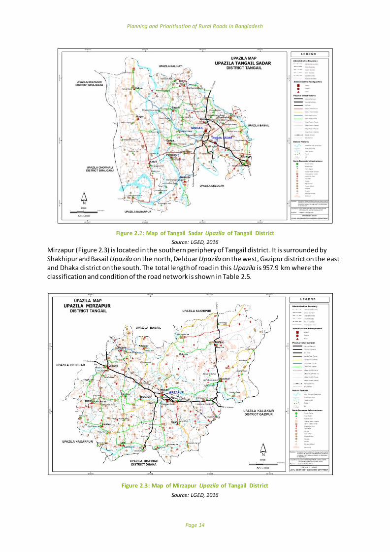
Field Visit The BUET team visited Tangail Sadar and Mirzapur Upazilas on April 19, 2016. Tangail Sadar (Figure 2.2) is located at the western periphery of Tangail and is surrounded on the north by Kalihati Upazila, to the east by Basail Upazila, to the south by Delduar and Nagarpur Upazila and to the west by Sirajganj district. There is a total of 489.52 km road across the Upazila where the category and condition of these roads are given in Table 2.5.
Planning and Prioritisation of Rural Roads in Bangladesh
Page 14
Figure 2.2: Map of Tangail Sadar Upazila of Tangail District
Source: LGED, 2016
Mirzapur (Figure 2.3) is located in the southern periphery of Tangail district. It is surrounded by Shakhipur and Basail Upazila on the north, Delduar Upazila on the west, Gazipur district on the east and Dhaka district on the south. The total length of road in this Upazila is 957.9 km where the classification and condition of the road network is shown in Table 2.5.
Figure 2.3: Map of Mirzapur Upazila of Tangail District
Source: LGED, 2016

Planning and Prioritisation of Rural Roads in Bangladesh
Page 15
During the field visit, a consultation meeting was conducted with LGED and other field level officials of government agencies and Union Parishad councillors to explore the possibility of collecting data relevant for the study. The BUET team also explained the methodology of the research and mentioned the list of data needed for the research. The officials agreed to extend their support in collecting data required for the study.
2.2 Names of Implementing Agency and Delivery Organisation
Implementing Agency: Department of urban and Regional Planning (DURP), Bangladesh University of Engineering and Technology (BUET), Dhaka, Bangladesh. Delivery Organization: Department of urban and Regional Planning (DURP), Bangladesh University of Engineering and Technology (BUET), Dhaka, Bangladesh.
2.3 Key Dates
Start Date: 7th April, 2016 End date: 6th April, 2017 (Original); 21th June, 2017 (Proposed)
2.4 Approved Cost of the Initiative
GBP 120,000.00 (approved); GBP 133,800.00 (proposed budget including additional task)
3 Background
Research for Community Access Partnership (ReCAP) is a six-year programme with an overall aim to promote safe and sustainable rural access in Asia and Africa. Bangladesh’s Local Government Engineering Department (LGED) has been an active participant in the programme. RECAP awarded the Department of Urban and Regional Planning (URP) at Bangladesh University of Engineering and Technology (BUET), Dhaka to conduct the project ‘Planning and Prioritisation of Rural Roads in Bangladesh (Project reference: BAN2072A)’ in April 2016 on the basis of the proposal submitted by the department on January, 2016 .
3.1 Context and Objectives of the Study
The Local Government Engineering Department (LGED) manages all rural roads which form more than 93% of total roads or about 321,462 km of roads. The Roads and Highways Department (RHD), the national highway authority of Bangladesh, manages the highways and Zila (District) roads of the country. The different categories of roads and their responsible agencies are given in Table 3.1.
Table 3.1: Categories of Roads in Bangladesh along with their Responsible Authority
Road Category Definition Responsible
authority
National Highway Highways connecting National capital with Divisional HQs or seaports or land ports or Asian Highway.
RHD
Regional Highway Highways connecting District HQs or main river or land ports or with each other not connected by National
Highways.
RHD
Zila (District) Road
Roads connecting District HQs with Upazila HQs or connecting one Upazila HQ to another Upazila HQ by a single main connection with National/ Regional Highway, through shortest distance/route.
RHD
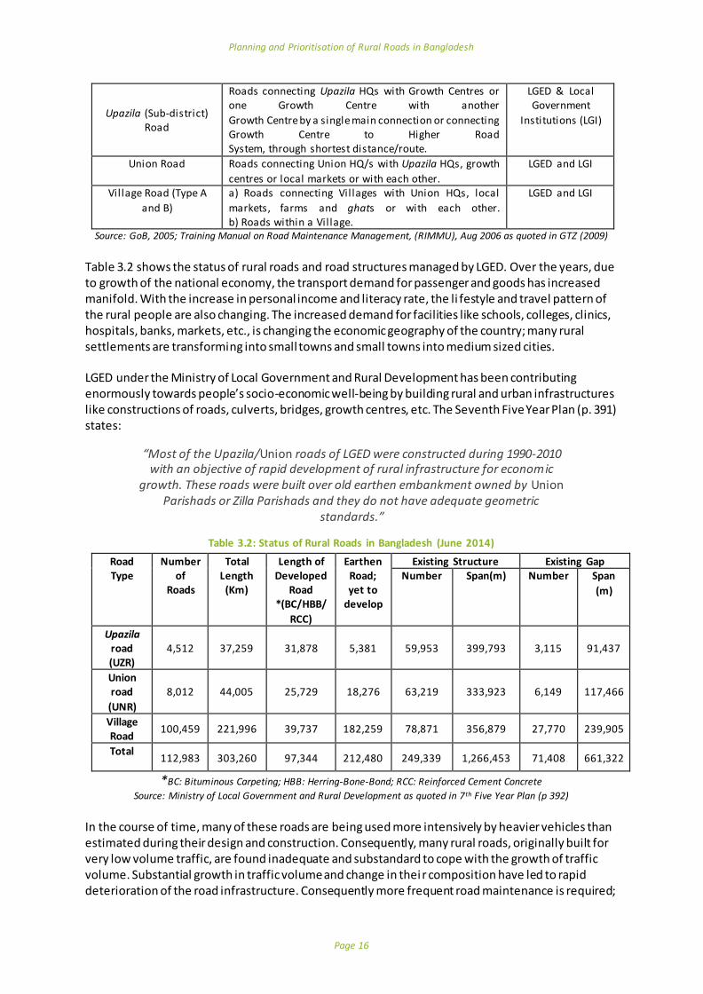
Planning and Prioritisation of Rural Roads in Bangladesh
Page 16
Upazila (Sub-district) Road
Roads connecting Upazila HQs with Growth Centres or one Growth Centre with another
Growth Centre by a single main connection or connecting Growth Centre to Higher Road System, through shortest distance/route.
LGED & Local Government
Institutions (LGI)
Union Road Roads connecting Union HQ/s with Upazila HQs, growth
centres or local markets or with each other.
LGED and LGI
Vil lage Road (Type A
and B)
a) Roads connecting Villages with Union HQs, local
markets, farms and ghats or with each other. b) Roads within a Vil lage.
LGED and LGI
Source: GoB, 2005; Training Manual on Road Maintenance Management, (RIMMU), Aug 2006 as quoted in GTZ (2009)
Table 3.2 shows the status of rural roads and road structures managed by LGED. Over the years, due to growth of the national economy, the transport demand for passenger and goods has increased manifold. With the increase in personal income and literacy rate, the li festyle and travel pattern of the rural people are also changing. The increased demand for facilities like schools, colleges, clinics, hospitals, banks, markets, etc., is changing the economic geography of the country; many rural settlements are transforming into small towns and small towns into medium sized cities. LGED under the Ministry of Local Government and Rural Development has been contributing enormously towards people’s socio-economic well-being by building rural and urban infrastructures like constructions of roads, culverts, bridges, growth centres, etc. The Seventh Five Year Plan (p. 391) states:
“Most of the Upazila/Union roads of LGED were constructed during 1990-2010 with an objective of rapid development of rural infrastructure for economic
growth. These roads were built over old earthen embankment owned by Union Parishads or Zilla Parishads and they do not have adequate geometric
standards.”
Table 3.2: Status of Rural Roads in Bangladesh (June 2014)
Road Type
Number of
Roads
Total Length
(Km)
Length of Developed
Road *(BC/HBB/
RCC)
Earthen Road; yet to
develop
Existing Structure Existing Gap Number Span(m) Number Span
(m)
Upazila road (UZR)
4,512 37,259 31,878 5,381 59,953 399,793 3,115 91,437
Union road
(UNR)
8,012 44,005 25,729 18,276 63,219 333,923 6,149 117,466
Village Road
100,459 221,996 39,737 182,259 78,871 356,879 27,770 239,905
Total 112,983 303,260 97,344 212,480 249,339 1,266,453 71,408 661,322
*BC: Bituminous Carpeting; HBB: Herring-Bone-Bond; RCC: Reinforced Cement Concrete
Source: Ministry of Local Government and Rural Development as quoted in 7th Five Year Plan (p 392) In the course of time, many of these roads are being used more intensively by heavier vehicles than estimated during their design and construction. Consequently, many rural roads, originally built for very low volume traffic, are found inadequate and substandard to cope with the growth of traffic volume. Substantial growth in traffic volume and change in thei r composition have led to rapid deterioration of the road infrastructure. Consequently more frequent road maintenance is required;

Planning and Prioritisation of Rural Roads in Bangladesh
Page 17
accidents on rural roads are also taking place with increased frequency and severity. There is a need to upgrade their width and other geometric features as well as construction standards. Figure 3.1 shows the share of roads to be developed. Although LGED spends a considerable amount of resources for the improvement of rural roads, the selection of roads from a large number of candidate roads is not undertaken through a rational selection process. Consequently, many roads of higher importance often remain neglected while roads of lower importance are allocated resources for development and/or upgrading. For the effective utilization of available resources, there is a need to develop a prioritisation methodology for the development, upgradation and maintenance of the rural roads.
Figure 3.1: Share of Developed and yet to be Developed Rural Roads in Bangladesh
Source: Based on Table 3.2
The Seventh Five Year Plan of Bangladesh FY2016 -FY2020 has outlined priorities for rural road development (Planning Commission, 2015, pp 391-394). These priorities, among others, include:
To Double lane/Upgrade and maintain selected busier Upazila Roads, Union Roads having by a large number of commercial vehicles. At the same time, connection with rural roads with railway and waterways will be given priority in order to promote and integrate multimodal transport system;
To improve Upazila Roads, Union Roads and prioritised Village Roads which have strategic importance to connect road network, railway and waterways.
The plan also identifies major strategies as follows:
Rural infrastructure development/ improvement will be planned and implemented based on the findings of Effect/ Benefit/ Impact/ feasibility studies; and
A simpler and quicker way for feasibility study and deriving the ERR will be developed for the rural roads. There are competing needs for various types of rural infrastructure, such as, Upazila Roads, Union Roads, Markets, Ghat facilities, etc., and even for roads alone, there is need for improved maintenance and bridging the gaps. At the spatial level, there are

Planning and Prioritisation of Rural Roads in Bangladesh
Page 18
competing needs for different geographical regions. A guideline for investment prioritisation and selectivity will be developed and calculation of economic rate of return will be adopted to guide the major investment decisions.
Rural Road Master Plan of LGED will be updated. The updated Master Plan will be followed for infrastructure development projects covering Upazila and Union roads including bridges/culverts, bridges/culverts on Village roads and development of growth centres/markets, ghats and Union headquarters.
LGED is required to prepare a master plan for Upazila roads, Union roads and Village Roads along with Growth Centres/Rural Markets, Union Parishad Complex, etc. In the process, the Upazila Engineer updates the road inventory of Upazila as per necessity and send the updated version of the inventory of roads and other facilities, and the map to the GIS Unit at the LGED head office for maintaining the updated GIS database at the national level.
The stated main objectives of the Rural Road Master Plan are as follows:
To identify and prioritise a useful and effective rural road network throughout the country to ease the rural life as a whole
To provide all-weather access to all Growth Centres, all Union Parishads Complexes, most of the rural markets and other service delivery centres in rural areas
To improve rural accessibility for facilitating agricultural production and marketing of different products
To reduce poverty through employment generation and accelerating economic activities in rural areas
To strengthen the Local Government Institutions and promoting local governance by providing technical assistance as needed.
Considering the above-mentioned rural road development objectives, policies and strategies, the overall aim of the present study is to develop an appropriate planning and prioritisation methodology and a user manual for the development of low volume rural roads. It will eventually facilitate the updating process of the Upazila road master plan and the investment decisions for rural road development in Bangladesh.
3.2 Problem Analysis
The traffic volume and their composition along the Upazila, Union and Village roads are not the same. While a relatively large number of commercial vehicles use Upazila and Union roads, Village roads are mostly used by different types of NMTs and pedestrians. Therefore, a common planning and prioritisation methodology for the development of these roads will not be appropriate. Since, a relatively large number of commercial vehicles use Upazila and Union roads, the benefits of their development can be estimated in terms of savings in vehicle operating costs and travel time. The conventional cost benefit analysis methodology can be applied to estimate such benefits and thereby assess the development potential of such roads. It is, however, important to note that these roads also provide access to the people living along such roads many of whom may not be using any vehicular traffic. In order to make a more complete assessment, these kinds of benefi ts from access also need to be estimated. In case of Village roads, the benefits of road development mainly accrue in the form of access benefits to the Village people. These benefits are difficult to estimate and quantify in monetary terms. Also, the volume of vehicular traffic on Village roads is very low compared to that of Upazila and Union Roads. For this reason, benefits in terms of savings in vehicular ope rating costs and travel times are expected to be negligible. Therefore, the conventional cost benefit analysis for the assessment of benefits of Village roads may not be appropriate in the current context of Bangladesh.
Planning and Prioritisation of Rural Roads in Bangladesh
Page 19
In such backdrop, a separate methodology is required to assess the benefits of access of a road to the Village people. Another major challenge is to overcome the limitations of data from LGED and other secondary sources. Very limited types of data are available from such sources. Further, the geographical units of data collection by different government departments are not always the same. In order to make all such data usable for the present purpose, some estimation procedure will have to be worked out. It is envisaged that collection of any additional data which are not available from secondary sources, would be limited. Only very essential additional data may be collected. Also, any updating of data what are available have to be done by following some simple procedures. The prioritisation methodologies that the present study seeks to develop should be generalized so that they may be applied all over the country as far as possible. However, such generalisations may not be an easy task as there exist considerable topographical and other variations across the country. The methodologies will have to take into considerations such variations as possible.
3.3 Literature Review
3.3.1 Introduction
A literature review reveals that the methodologies on rural road planning and development may be grouped into five broad categories:
Multi Criteria Analysis(MCA) (also known as Prioritisation ranking techniques)
Economic analysis (Cost Benefit analysis also referred to as Benefit Cost analysis) Participatory approaches
Network planning models based on optimization techniques
Hybrid methodologies - combination of multiple methodologies on road planning
In the context of the present study, these five broad categories are discussed next.
3.3.2 Multi Criteria Analysis (MCA)
Multi Criteria Analysis (MCA) or Prioritisation ranking (PR) techniques of rural roads have been widely used for the selection of rural road projects in many countries of Asia and Africa. A set of factors or criteria reflecting policy or social objectives of the government are selected for ranking of projects. Such factors may or may not include cost variables but may include variables such as population served, improvement of access to markets and services, impacts on natural systems, traffic volume, social and economic welfare etc. After selection of factors, their relative weights are established. The use of Analytical Hierarchy Process (AHP) is common for the establishment of relative weights of the factors. Finally, the priority score or index value of each candidate road project is calculated by summing the product of the value of each factor (often the actual value is normalized) by its relative weight. Many good examples on application of MCA can be found in the literature, for example, ESCAP (1979), Greenstein and Bonjack (1983), UNCHS (1985), Lebo and Schelling (2001), Hine et al. (2003), Bhandari et al. (2014), and Philippine Rural Development Project (2015). It may be noted that currently LGED uses some criteria such as classification of roads, surface type, gaps, traffic volume (CVD), fund source, markets, hospitals, social centres, educational centres and industry, and some relevant weights of these criteria for prioritisation of rural roads. However, apparently the selection of these criteria and assignment of their weights do not follow any rational basis. The detail of this practice is discussed in section 3.3.7.

Planning and Prioritisation of Rural Roads in Bangladesh
Page 20
The MCA methodology is used to rank rural road investments, and is typically applied when traffic volumes are less than 50 vehicles per day and too low to apply the conventional cost benefit analysis to make sense, but there is a strong belief that there will be important social benefits arising mainly from improvement of access and connectivity. It is important to note here that in addition to such benefits, there are impacts of road investment on socio-economic development, or the so-called indirect- and induced benefits. Alternative impact assessment methods may be used to assess such benefits. This can be supported by additional data collection methods through which the proposed impact of rural road investments can be estimated and measured by obtaining views from communities with respect to the expected impact on socio-economic conditions on communities. A study by Ahmed and Hossain (1990) in Bangladesh is a good example for such impact assessment. It may be worth mentioning here that the Roads and Highways Department of Bangladesh has developed a methodology for prioritisation of national and regional highways considering importance of service centres, condition of road, and level of services required. The Project Appraisal Framework prepared by the Planning Commission adopted a multi -criteria evaluation framework for road projects incorporating a set of equity and efficiency criteria for the selection and prioritisation of highway projects (Planning Commission, 2005). Generally, indicators used in MCA implicitly reflect economic and subjective evaluations (Lebo and Schelling, 2001). If the weights and factors are decided upon and allocated in a participatory way, MCA has the potential to be a participatory planning method (see discussions below on participatory approach). The MCA methodology should not be applied without consul tation with the concerned users and stakeholders. The outcome of the MCA methodology can become non-transparent, especially if too many factors are considered and a complicated formula applied to determine an index value or priority score. Therefore, as suggested by Lebo and Schelling (2001), if adopted, this method should be kept simple, transparent, and participatory. Despite all the advantages of MCA, its main caveat is the inability to compare the benefits with respect to the costs. In order to address this problem, Gühnemann, Laird, and Pearman (2012) developed an integrated approach where they combined CBA and MCA for effectively evaluating road development projects. With this approach the strengths of both methods are retained.
3.3.3 Economic Analysis (Cost Benefit Analysis)
The application of Cost Benefit Analysis (CBA) has been widely adopted in analysing the merits of road investment projects in both developing and developed countries. CBA has been popular among the decision makers as it provides a systematic framework to evaluate all costs and benefits of a project. In short, CBA identifies and estimates in monetary terms all costs and benefits of a project during its (economic) lifetime, discounts them to a reference point in time (generally the present year), and compares to see if the summation of benefits exceed the summation of costs. The commonly applied assessment criteria for project selection include, Benefit Cost Ratio, Net Present Value, Internal Rate of Return, Payback Period, etc. There are several conventional approaches to estimate the benefits of road development. The User Cost Saving (UCS), Vehicle Operating Cost Saving (VOCS) and (Travel Time Cost Saving (TTCS), and Agricultural Product Surplus Method (APS) are among such conventional approaches. However, in recent years, the most commonly applied CBA methodology follows the VOCS and TTCS approach. This approach has also been applied in Bangladesh for many road infrastructural development projects (for example, PRMIMP-II, RDP, TRIDP, RDP-24, RIIP-I and RTIP) (LGED, 2004).

Planning and Prioritisation of Rural Roads in Bangladesh
Page 21
Due primarily to its wide application and popularity among decision makers, several computer based CBA models have been developed to provide a harmonized approach to economic evaluation of road projects. One of the most well-known such model is the Highway Design and Maintenance Model (HDM) developed by the World Bank. The original model did not include the maintenance issue. The HDM-III, introduced in 1980s, included the maintenance issue. However, this model had many limitations especially reliance on vehicle operating cost which may not be very relevant in the context of rural roads in developing countries. A new model, HDM4 was developed to address the limitations of the HDM-III model. HDM4 is a completely new software package which can be used as the primary tool for the analysis, planning, management and appraisal of road maintenance, improvements and investment decisions. A major limitation of HDM4 is that it cannot be used for low-volume roads; suitable for use of roads with 200 or more vehicles. Other limitations include the model cannot capture all benefits of rural road investments, not customized for unpaved roads and requires huge data inputs which may be impractical to collect for rural roads (Archondo-Callao, 2004). The World Bank developed a separate economic evaluation model, the Roads Economic Decision (RED) model, suitable for the characteristics and needs of low volume rural roads. The model is adapted for low-volume unpaved roads, with traffic volumes between around 50 and 300 vehicles per day. The model performs an economic evaluation of road investment options using the consumer surplus approach and is customized to the characteristics of low-volume roads such as the high uncertainty of the assessment of the model inputs, particularly the traffic and condition of unpaved roads, the importance of vehicle speeds for model validation, the need for a comprehensive analysis of generated and induced traffic, and the need to clearly define all accrued benefits (Archondo-Callao, 2004). Despite its popularity and wide application, CBA has many serious limitations which are well documented in the literature. The conversion of nonmonetary costs and benefits into monetary values is questionable. Another major criticism is that CBA is essentially an economic efficiency criterion; it does not consider equity or fails to capture government’s policy objectives, for example, social and economic wellbeing of people. There are also other difficulties in applying CBA; some of these include, obtaining reliable information on costs, estimating the costs and benefits of externalities, estimating benefits due to shift of demand (which may be very significant especially in case of rural roads), and accounting for the impacts outside the geographical scope of the project. Also, the CBA methodology is not suitable for very low-volume rural/Village roads. However, as mentioned in the previous section on MCA, CBA can be combined with other methodologies to overcome its limitations as well as to make the methodology more appropriate in a given context.
3.3.4 Participatory Approaches
Participatory approaches to planning increases the likelihood that actions taken or services provided by public agencies more adequately reflect the needs of people. Public participation is understood as a process in which all concerned stakeholders including the beneficiaries and affected people are involved in decision-making about development works. Considering the merits of such approaches models have been developed for planning of infrastructure facilities and various public services. In the context of rural infrastructure development probably the most well-known is the Integrated Rural Accessibility Planning (IRAP) methodology developed by the International Labour Organization (ILO).

Planning and Prioritisation of Rural Roads in Bangladesh
Page 22
IRAP is an area-based planning process to identify the actual access needs of the local communities and define and prioritise interventions to improve access. Interventions to either improve rural mobility (such as roads, bridges and tracks) or improve the distribution of facilities and services (such as water supplies, schools and health centres). The whole process is participatory and involves the local communities and local government officials representing the different sectors. In short, the RAP methodology calculates accessibly Indicators (AI) by multiplying the number of households (N) with the subtraction of the average travel time to a facility (T) minus the acceptable/target travel time Tm, times the frequency of travel (F): AI=N*(T-Tm)*F. Finally, maps are established with the available information. The larger the value of the AI, the greater the problem and higher the priority for improving access to that facility. Further details of the model can be found in Donnges (2001) and elsewhere. The IRAP methodology has been applied in the Philippines and many other countries for Village level accessibility planning. Sarkar and Dash (2011) developed a modified version of IRAP and applied it in India. The major limitation of the participatory approach to planning is that it requires an institutional setting to apply the approach. In the absence of such an institutional setting, as in the case of Bangladesh, there is little chance of executing such approach or implement the outcome of any such exercise. These approaches are more suitable in situations where local level planning is fully institutionalized within local bodies.
3.3.5 Network Planning Models based on Optimization Techniques
CBA and PR techniques may not be always suitable for the selection of rural road projects. In both the cases there is an implicit assumption of project independence. However this assumption may not be valid especially in the early stage of rural road network development. A particular road (or link) in the network may not get priority for development considering its own merits but could be a vital link of the network. Without its development the network as a whole may only be partially functional and therefore of limited utility to the people. In other words, the functional utility of many roads in the network and the network as whole are dependent on this particular road of lesser priority. Researchers have applied some network development models such as the Minimum Spanning Tree (MST) and other network development models (which are based on Graph Theory) to address this issue of independence. In short, an optimum network of roads is identified by applying the MST model which minimizes the total length of the road network in connecting all Villages with the nearest market/service centre by linking the Village directly with that centre, or to another Village which is already connected to such a centre, or to an existing road link which in turn serve as a link to a centre. Good examples of network development models in rural areas of Bangladesh and Nepal can be found in Oudheusden and L. R. Khan (1987) and Shrestha et al. (2013). The major limitation of such models is that if the network is already developed more than the basic minimal network to connect all market/service centres, as would be the case in most parts of Bangladesh, such models do not work well. Another limitation is that because of their analytical sophistication, usually it may not be easy to apply such models in all situations.
3.3.6 Hybrid Methodologies – Combination of Multiple Methodologies on Road Planning
All of the above-discussed broad categories of methodologies have their weaknesses as well as advantages over the other categories. In many respect, the suitability of these methodologies also depend on the context or situation. In order to overcome their methodological weaknesses, especially in a given context, often a combination of methodologies has been suggested by researchers. For example, Gühnemann et al. (2012) combined MCA and CBA to capture the best of both. In another example, Shrestha (2003) in his methodology for district road network planning and

Planning and Prioritisation of Rural Roads in Bangladesh
Page 23
prioritisation in Nepal has used a network planning model, CBA, and a prioritisation index based on four criteria (agricultural potential, interaction, accessibility and environmental impact. Another strand of work found in the literature is the application of GIS-based models incorporating accessibility planning. For example, Singh (2010) developed a methodology for rural road network planning model for developing countries. The model is based on the concept of accessibility and was applied in Paithan Taluka, India. An index of accessibility was designed which evaluated various rural road link options for their efficiency in accessing the missing functions in the unconnected settlements. A GIS based technique for the analysis of alignment of new road link options was developed which considered the topographic and land use characteristics of the area. This approach offered maximum benefit to the unconnected settlements in terms of access to various facilities or the main road network.
3.3.7 Prioritisation of rural roads by LGED: Current Practice
As mentioned earlier LGED is responsible for developing and maintaining rural roads in Bangladesh. At present LGED does not have a standardized methodology for prioritisation of rural roads, though for maintenance of road they currently follows a two-step process. It identified several indicators, classified and assigned rating to the indicators (Table 3.3). At first, number of all the indicators along the roads are identified and each indicator/group of indicators are then multiplied by their respective assigned rating value. In the next step, summation of all the scores provides the total score of the road. Prioritisation is determined through comparison of the total points of all candidate roads for maintenance. Roads with higher score are given higher priority.
Table 3.3: Ratings of Indicators used by LGED for Prioritisation of Road
Indicator/Group Description Rating*
Classification Upazila Road 12
Surface Type Fully BC 0
Gaps Major Gaps 3
Traffic Volume AADT 1000+ 100
Market Growth Centre 12
Rural Market 6
Hospitals Upazila Health Complex 9
Social Centres Union Parishad Office 12
Other Public Centre 6
Educational
College 9
Secondary School 6
Primary School/Madrasha 3
Source: RSDMS software, LGED
Guidelines for Rural Roads and Culverts Maintenance (LGRDC, 2013), provides LGED a good policy support in maintaining its infrastructures and assets throughout the country. It provides a checklist for considerations while prioritising maintenance requirements. Higher priority is given for periodic maintenance, higher order roads, donor funded roads, roads having higher traffic volume and bus routes, continuous and uninterrupted link providing roads, roads providing accessibility to more growth centres, Villages, service/activity centres.

Planning and Prioritisation of Rural Roads in Bangladesh
Page 24
It is worth mentioning during discussion with LGED officials (Rahim, 2016 and Azad, 2016) the BUET team was informed that at in a CARE funded projects, a methodology was developed for calculation of benefits of improvement and further improvement of roads in the project area. To calculate the benefit, this methodology only considered the types and amount of agricultural items produced within one kilometre radius along the road. This methodology has not been used further in any other LGED project.
An attempt has been made to prioritise to Feeder Road Bs (FRB1) and important Rural Road 1s
(RR12) roads to be improved and maintained under the 2nd Phase of Rural Roads Markets
Improvement and Maintenance Project (RRMIMP-II) which were implemented in 21 districts of Bangladesh (LGRDC, 2002). Initially the districts were ranked on the basis of spatial characteristics, demographic characteristics, socio-economic characteristics, status of infrastructure, revenue contribution, institutional capacity and governance and community/public participation. The roads in districts with higher priority was considered for further analysis. The consultants identified six factors important for prioritisation of roads. However, due to the limitations of data, only two criteria were considered for prioritisation of important RR1s: community ranking and Benefit-Cost Ratio To prioritise FRBs for improvement, six factors were considered important: FRB Status (core /non- core), growth centre connectivity (primary / secondary), growth centre development status (developed / undeveloped) and community rank (numerical value, provided by community, of preferences and priorities in plan implementation and maintenance programmes within their local area), Benefit - Cost Ratio and status of connecting FRA. LGED conducted several monitoring and evaluation report to identify the impacts of its Rural Infrastructure Improvement Projects (RIIPs). These reports summarise the impact of the projects comparing baseline and end of project condition in project and control areas with respect to several socio-economic indicators (LGED 2010; LGED 2011). These reports used several sources for inputs used for economic analysis assuming 6% growth of transport. The Economic Analysis (EIRR) has been carried out for 20 years of economic life, on the basis of total investment cost including construction, land acquisition, environment mitigation measures and annual maintenance cost; and Vehicle Operating Costs (VOC) savings with and without passenger time savings (LGED 2010; LGED 2011). Merits and Demerits of the Current LGED Practice It is clear that LGED uses no prioritisation methodology for improvement or further improvement of roads. CARE project once used a methodology which used a very simple procedure for assessing the potential benefits of road improvement; besides it was applicable for the project area alone. Similarly, in RRMIMP a very simple methodology was used for prioritising roads in 21 districts. Methodology used for prioritisation of roads for maintenance has some rational basis but the scores that are given to indicators are subjective; discussion with LGED officials reveals that these scores were subjectively put by some experienced officials. Prioritisation methodology used in RRMIMP study considered only the improvement of FRB and RR1 networks. In fact, while making a generalised methodology in a context where all necessary data are
1 FRB stands for Feeder Road (Type B), which has been renamed as Upa zila Road (UZR) in the categorization of
rural/LGED roads in Bangladesh 2 RR1 stands for Rural Road (Type 1), which has been renamed as Union Road (UR) in the categorization of
rural/LGED roads in Bangladesh

Planning and Prioritisation of Rural Roads in Bangladesh
Page 25
not readily available throughout the country and where field context differs from one place to another, adopting a sophisticated CBA methodology is not practical. Therefore considering a simple methodology by RRMIMP is justified. Moreover, in RRMIMP all the FRBs and RR1s were considered.
Recognizing the ‘vast extent of work’ the scope was restricted to ‘Core’ FRBs and ‘Important’ RR1s 3.
Main advantage of RRMIMP technique is that the total score of a road under consideration is an absolute value and therefore allows independent calculation of scores. This is useful when new roads need to be added into the priority list. However, major problems are of RRMIMP methodology are: (a) there is no rational basis for scoring the indicators, scores are given subjectively; (b) indicators are not compatible with LGED’s current RSDMS platform; (c) no interfacing of the database with GIS platform; (d) the methodology has been developed for a particular project and for a particular area, application of the methodology has not been considered for the whole country.
3.4 Choice of Methodology for the Present Study
In terms of traffic and functional characteristics, Upazila and Union roads in Bangladesh are noticeably different from the Village roads. By Village roads here we mean inter-Village roads or roads that connect a Village with a higher order road such as an Upazila or Union road but do not include intra-Village roads.
3.4.1 Village Roads
For traffic levels below 50 VPD, as would be case of most Village roads in Bangladesh, the consumer surplus approach needs to be customized as the main benefits do not arise from savings in motor vehicle operating costs, but from the provision of access itself. Also, traffic on such very low volume Village roads typically consists of a majority of non-motorised vehicles such as rickshaw vans and cycles (where part of the costs are human energy needed to pedal the vehicles, which cannot be easily priced), animal transport such as haulage by bullocks, walking and head loading. The traditional CBA is therefore difficult to apply in such a situation. Some form of MCA is considered to be most appropriate for the assessment of Village road investment projects. The RED User Guide also recommends that the appraisal of very low volume roads with traffic volume less than around 50 vehicles per day is best treated with a multi -criteria analysis or cost effectiveness analysis (Lebo and Schelling, 2001). This view is also supported by Ahmed and Hossain (1990), GIZ (2014) and other studies. We therefore propose to use an MCA for Village roads. The benefits of access are difficult to quantify. However, access benefits can be perceived to be a function of population and the predicted change in unit transport cost. This implies that greater the change in transport cost and larger the population benefited, the greater the access benefits. The access benefits may include the following:
Improved accessibility to social infrastructure (schools and health centres) enhances opportunities to access education and health facilities. Enhanced social interaction and mobility can also facilitate social and economic development;
Improved access to markets by reducing transport costs;
Improvement of the marketability of perishable goods through timely and cheaper transport; an increase in rural income and additional employment opportunities.
3 Core FRBs has been defined as those which satisfy the functional definition of FRB namely; roads which connect
Growth Center markets at one end with Upazila Headquarters or RHD road network or another Growth Center or another FRB at the other end. While all RR1s identified by the Upazila Engineers have been considered as important RR1s.
Planning and Prioritisation of Rural Roads in Bangladesh
Page 26
Other than the above typical access benefits, the proposed MCA methodology for prioritisation of Village roads may also include access benefits to local agriculture, network connectivity, passability of the road in all seasons, and other local priority of special nature (for example, access to cyclone shelters, access to ghats and public transport stops, stations etc.), and construction and maintenance costs. Further details on the proposed MCA for Village roads are provided in the following chapter on methodology.
3.4.2 Upazila and Union Roads
The majority of unpaved Upazila and Union roads, which may be developed by LGED in the near future, are expected to be low-volume roads with less than 300 VPD (LGED, 2010).This makes their investment assessment suitable by using a CBA similar to the one included in the RED model. The RED model performs an economic evaluation of road investment options. Benefits are calculated for traffic components and are also expressed mainly in terms of savings in vehicle operating costs, travel time and accident costs. It may be mentioned here that the RED model computes benefits for normal, generated, induced, and diverted traffic, and takes into account changes in road length, surface condition, geometry, type, accidents, and days per year when the passage of vehicles is further disrupted by a highly deteriorated road condition (wet season). An advantage of the RED model is that users can add to the analysis other benefits, such as non-motorized traffic, social services and environmental impacts, if computed separately. The RED model is based on a series of Excel 2000 workbooks that collect all user inputs, present the results on an efficient manner and performs sensitivity, switching values and risk analyses. It may be possible to link RED from our own excel program. The project team holds the view that a CBA (using the RED model or otherwise) may not be sufficient to capture all the benefits from the improvement of unpaved Upazila and Union roads. We will explore the possibility of including an MCA in addition to the CBA for the assessment of Upazila and Union roads. The MCA will capture the access benefits to the people who may not be using vehicular traffic, benefits to non-motorized traffic, enhanced use of public/social services, connectivity and environmental impacts. Further details on the proposed MCA for Upazila and Union roads are provided in the following chapter on methodology.
3.5 Scope of Work
The prioritisation methodologies will not be solely based on economic evaluation of rural roads. Other important criteria such as, connectivity to higher order roads, benefits from providing access to socio-economic infrastructures, Agricultural Influence Area (AIA), and expected number of users affected may also be taken into account. Time or cost savings due to improvement of roads may be considered depending on the availability of the required data and LGED’s ability to collect those data in the future to run the model to be developed. IRR will be calculated for Union and Upazila roads; for Village roads, however, it may not make much sense to estimate the IRR due to very low volume of traffic on them. The prioritisation methodology for Village roads should primarily consider people’s social wellbeing from improved access and indirectly other economic and environmental factors. In consultation with LGED, it has been decided that the prioritisation methodologies will be developed considering Tangail as the pilot district. However, these methodologies should be generalized to be applicable to all over Bangladesh. It is expected that traffic volume data colle cted

Planning and Prioritisation of Rural Roads in Bangladesh
Page 27
by LGED for rural roads in other areas will also be shared with the BUET team. Since the field surveys of this task are expected to be undertaken mainly during the dry season, information on the accessibility and use of roads in the other seasons will be collected from local leaders and other knowledgeable persons. The prioritisation models should be simple and easy to use and may not require any vast amount of additional data collection. They should be integrated with the existing GIS database of LGED so that visualisation of the prioritisation results can be possible. It is expected that the tools (computer-based prioritisation models) will be used both at the LGED’s head office and its district and Upazila offices. While the head office and the district offices should be able to use the full features of the computer-based models and GIS based outputs, the Upazila offices, due to their limited capacities and lack of logistics facilities, may not be able to use the full features of the models.
Planning and Prioritisation of Rural Roads in Bangladesh
Page 28
4 Approach and Methodology
4.1 Research Objective
To examine existing prioritisation methods in Bangladesh and other similar countries and determine whether they provide optimal solutions for rural roads;
To develop a prioritisation method, software and user manual for Bangladesh and test it in a region for gaining full confidence; and
To train 15 professionals on the use of the planning and prioritisation tool.
Links to RECAP Logframe.
4.2 Links to ReCAP Logframe
The project would address output 2 and output 3 of RECAP logframe (See Annex B). It should be noted that the project output may be published in peer-reviewed journal or presented in international conference/ workshop. However, publishing research output is not the objective of the project. BUET team has developed one Logframe matrix based on the objectives of the project which is given in Annex C. The overall aim of this project is to develop an appropriate planning and prioritisation methodology and user manual for the provision and upgrading of low volume rural roads in Bangladesh.
4.3 Given Conditions, Important Considerations and Assumptions
Prior to developing the methodology, the project team have reviewed the literature on rural road development in Bangladesh and its neighbouring countries as well as in some other Asian and African countries. The team also had several rounds of consultation meetings with LGED officials in Dhaka, and met field-level government officials, elected officials, local leaders and other knowledgeable persons in two Upazilas of Tangail, the selected pilot district. The main purpose of such consultation meetings were:
To have a clear understanding of the issues in rural road development;
Requirements of LGED; Opinion of local leaders, people and other stakeholders on benefits and impacts of rural
roads and their prioritisation; and
Availability of information from secondary and other local sources. On the basis of our consultations and information made available to us, we have taken into account the following important considerations, given conditions and assumptions in developing the methodology:
Government policy on rural roads as outlined in the Seventh Five Year Plan (SFYP)(see pp. 392-93) and other official documents;
It is envisaged that generally no new rural roads will be constructed. The existing roads, as needed and prioritised, may be further developed and/or upgraded;
The current practices of LGED, methodologies in previous studies Regional Road Network Study for Prioritisation under RRMIMP-II (LGED, 2002) and Guidelines of the Project Appraisal Framework (PAF) prepared by the Planning Commission (Planning Commission, 2005);
Planning and Prioritisation of Rural Roads in Bangladesh
Page 29
The selection of rural roads for development should be based on a set of prioritisation criteria which should reflect road investment costs, usual direct benefits to road users (where such estimation is possible), improved accessibility to markets and social infrastructure facilities, benefits to local agriculture, connectivity, passability of the road in all seasons, and other local priority of special nature (for example, access to cyclone shelters, access to ghats and public transport stops, stations etc.);
Maximum utilisation of the LGED’s current GIS database; Minimum new data collection, which should be available from secondary sources such as
LGED and other government departments and other local government sources. Unless otherwise essential, primary data collection should be avoided;
In case of Village roads, EIRR may not be an appropriate criterion for prioritisation of roads. Some multi-criteria analysis (MCA) reflecting benefits from improved access, benefits to agriculture and special local needs may be considered;
For prioritisation of higher order Upazila and Union roads, in addition to EIRR other criteria such as, connectivity with RHD roads and centres in the neighbouring Upazila, and environmental factors may be considered.
It was mentioned in the previous section that because of the difference in traffic and functional characteristics, two separate prioritisation methodologies will be appropriate for the appraisal of rural roads – one for the Upazila and Union roads and a second one for Village roads. As a relatively large number of commercial vehicles use Upazila and Union roads, the benefits of Upazila and Union roads may be estimated in terms of savings in vehicle operating costs and savings in travel time. A conventional cost benefit analysis methodology may be applied to estimate such benefits and costs. However, these roads also provide access benefits to the people living along such roads many of whom may not be using any vehicular traffic. In order to make a more complete assessment, the access benefits to such people also need to be estimated. Village roads are mostly used by NMTs and pedestrians. The volume of vehicular traffic on Village roads is expected to be very low. Benefits in terms of savings in vehicular operating costs and time savings are expected to be insignificant. Therefore, a conventional cost benefit analysis for the appraisal of Village roads may not make much sense. The benefits of Village roads, however, would come mainly in the form of access benefits to the Village people. A separate MCA methodology will be developed to assess the access benefits of Village roads to the local people.
4.3.1 Selection of Criteria for Prioritisation of Rural Roads
The proposed two prioritisation methodologies will address the three pillars of sustainability namely, economic, social and environmental. A set of prioritisation criteria for the assessment of costs, benefits, and social and environmental effects will be selected which should reflect these three pillars of sustainability. They may include road investment costs, direct user benefits to road users (where such estimation is possible), improved accessibility to markets and social infrastructure facilities, benefits to local agriculture, connectivity, passability of the road in all seasons, and other local priority of special nature. An initial list of prioritisation criteria will be prepared considering the current practices of LGED, guidelines of the Project Appraisal Framework (PAF) prepared by the Planning Commission, opinion of stakeholders and literature review. However, their final selection and relative weights will be determined by applying the analytic hierarchy process (AHP) technique, which will require an opinion survey of policy makers, experts, rural people and other stakeholders.

Planning and Prioritisation of Rural Roads in Bangladesh
Page 30
4.4 Methodology for Prioritisation of Upazila and Union Roads
The following steps will be involved in determining the priority order for the development of Upazila and Union roads.
4.4.1 Identifying a Basic Upazila and Union Road Network
Besides rural roads for which LGED and local bodies are responsible, there can be national roads of different categories (National Highway, Regional Highway and Zila roads which are managed by the RHD) in an Upazila. The RHD roads complement the Upazila and Union roads to maintain connectivity between activity centres in an Upazila as well as connectivity with Zila headquarter and other higher order national centres. For the present study, roads managed by RHD will be considered as given roads and only the roads managed by LGED will be taken into account. All the designated Upazila and Union roads along with the national roads, if any, will form the basic network in an Upazila. The basic network will also include roads that crosses the geographical boundary of an Upazila to connect an activity centre or a national road in a neighbouring Upazila. In any prioritisation scheme all such roads will get additional importance as together they form a network vital to maintain inter- and intra-Upazila transport connectivity. The activity centres will form the nodes and Upazila and Union roads connecting them will be the links of the basic network. An example of an Upazila road network with different types of roads and their status is shown in map 4.1.
Figure 4.1: Upazila Road Network with Different Types of Roads in Mirzapur, Tangail District
Source: LGED GIS Database, 2010
4.4.2 Determination of the Importance of the Activity Centres
Rural centres and markets play a vital role for locating various facilities and services to serve the people living in their areas of influence. They connect settlements and Villages to such rural centres and markets of different orders. Four different categories of rural activity centres can be identified: Upazila and Union headquarters, Growth centres and rural markets. Determining the influence or

Planning and Prioritisation of Rural Roads in Bangladesh
Page 31
attractiveness of these activity centres (which defines their functional linkage with other centres and settlements) is an important consideration in prioritising rural roads. A centrality score, based on the number and order of selected functions, can be calculated for each of these activity centres to establish their relative importance or hierarchy. First, the relative w eights of the facilities at different activity centres will be determined by the Reed-Muench Threshold Population method (Haggett & Gunawardena, 1964). Second, summation of the products of the number of facilities and their respective weights will give the centrality score for each activity centre.
4.4.3 Determination of the Interaction Index of Roads
The next step will be to calculate an interaction index of a road connecting two centres based on the centrality scores of the centres and travel deterrence (distance, time, cost or any combination of them) between them. This index will be a measure of the intensity of interaction between the centres as well as an indication of the importance of the road connecting the two centres. A functional relationship between index values and actual current traffic volumes will be found by a regression analysis. This relationship between index value and traffic volume can be used to estimate traffic volume of roads for which no direct traffic count data may be available. An interaction index will be calculated following a gravitational model which is given below:
2
21
d
CCkII
II = Interaction index of a particular Upazila or Union road C1 = the centrality score of activity centre 1 C2 = the centrality score of activity centre 2 d = travel deterrence between two centres k = need to be determined
4.4.4 Determination of the Current and Future Traffic Volumes of Upazila and Union Roads
Traffic volume is an important criterion for determining the priority of any road development project. As explained above, roads for which updated traffic volume data may not be available, traffic volume will be estimated by using the regression model between traffic volume and the interaction index of the road. The expansion factor method will be used to estimate future traffic volume of roads. The basis of this growth factor can be population and economic growth and known trend in traffic volume growth.
4.4.5 Estimation of EIRR for Upazila and Union roads
The estimated future traffic volumes may give an indication of priority of the Upazila and Union roads. However, for a better assessment the conventional cost benefit analysis methodology will be used to calculate the EIRR (and other indicators of economic assessment such as NPV, B/C ratio etc.) for Upazila and Union roads. The cost components in the analysis will include updated standard
construction and maintenance costs for different categories of roads4 and road structures as used by
LGED. The benefits will be estimated in terms of travel time savings (TTS) for both passengers and goods and reduced vehicle operating costs (VOC) for different types of vehicles. Travel time savings will be converted into monetary terms. Benefits to generated traffic will be estimated at half of the rate of benefits to current traffic. The values of VOC and TTS will be taken from recent studies on
4LGED has established design and construction standards based on defined traffic volumes.
Planning and Prioritisation of Rural Roads in Bangladesh
Page 32
these parameters (for example, GTZ, 2009) and other evaluation studies. However, updating of the values may be necessary. For calculating EIRR, the project team will explore the possibility of using the RED software. Alternatively, estimation models similar to RED models will be used in the estimation of EIRR and other economic assessment criteria.
4.4.6 Estimation of other benefits
It was mentioned earlier that the Upazila and Union roads also provide social or access benefits to the people living along such roads many of whom may not be using any vehicular traffic. In order to make a more complete assessment, the social or access benefits to such people should also be estimated. A few simple criteria will be used to estimate such benefits. These criteria may include population served per km, number of facilities (such as schools) along the road, connectivity etc. which has a clear link to policy goals. The actual choice of indicators will be made after due consultation with policy makers, local leaders and other stakeholders as well as consideration of LGED’s current practice.
4.4.7 Development of an MCA scoring and weighting framework incorporating CBA results
Incorporation of CBA results into an MCA framework retains the strengths of both the appraisal methods and provides an overall socio-economic appraisal procedure for decision makers to create a ranking of all candidate Upazila and Union road projects. A simple MCA scoring and weighting framework is proposed to combine the results of CBA and social and environmental benefits (or costs) from improved access. The priority order for the development of Upazila and Union roads will be determined on the basis of their overall combined scores.
4.5 Methodology for Prioritisation of Village roads
The following steps will be involved in determining the priority order for the development of candidate Village roads.
4.5.1 Identification of a Basic Village Road Network
All Village roads that connect a Village directly with nearest activity centre, to another Village which is already connected to an activity centre, or an Upazila or Union road will form the basic Village network. All such roads will get additional importance as together they form a network vital to maintain transport connectivity at the Village level.
4.5.2 Selection of factors for Multi-Criteria Analysis (MCA)
An initial list of potential criterion for an MCA involving economic, social and environmental factors will be identified considering LGED’s current practice, views of experts and literature search. Table 4.1 provides a preliminary list of such potential criteria. The final selection of evaluation criteria and their relative weights will be determined by applying the Analytic Hierarchy Process (AHP) technique based on the outcome of an opinion survey among policy makers, experts, rural people and other stakeholders (See Annex J for a sample AHP questionnaire).

Planning and Prioritisation of Rural Roads in Bangladesh
Page 33
Table 4.1: List of Potential Criteria to Determine Priority of Village Roads
Criteria Valuation
Economic
Cost components
Construction cost of roads Monetary
Maintenance cost Monetary
Benefit Components
Value of agricultural products (per sq. km of road) Monetary
Direct road user benefits Monetary
Social
Benefit Components
Population served per square kilometre Non-Monetary
Facil ities served by the roads Non-Monetary
Connectivity of the roads to the higher order roads
Non-Monetary
Passability Duration of submergence Non-Monetary
Environ-mental
Drainage and flooding
Nature and likely severity of the problem Non-Monetary
4.5.3 Development of an MCA Scoring and Weighting Framework for Village
Roads
A composite score using the selected criteria will be calculated for all candidate Village roads. It is evident from the table that the values of the selected criteria are in different units and scale. The nominal values will be converted into dimensionless standard values before they are used to calculate the composite score. The equation for calculating the composite score is given below:
)( ii xwI
I = Composite index, wi = Relative weight of criteria i, xi = Value of criteria i
The priority order for the development of candidate Village roads will be determined on the basis of their composite scores. A tentative flow chart of the methodology is given in Figure 4.2. Possible sources of collecting the data are given in Table 4.2.
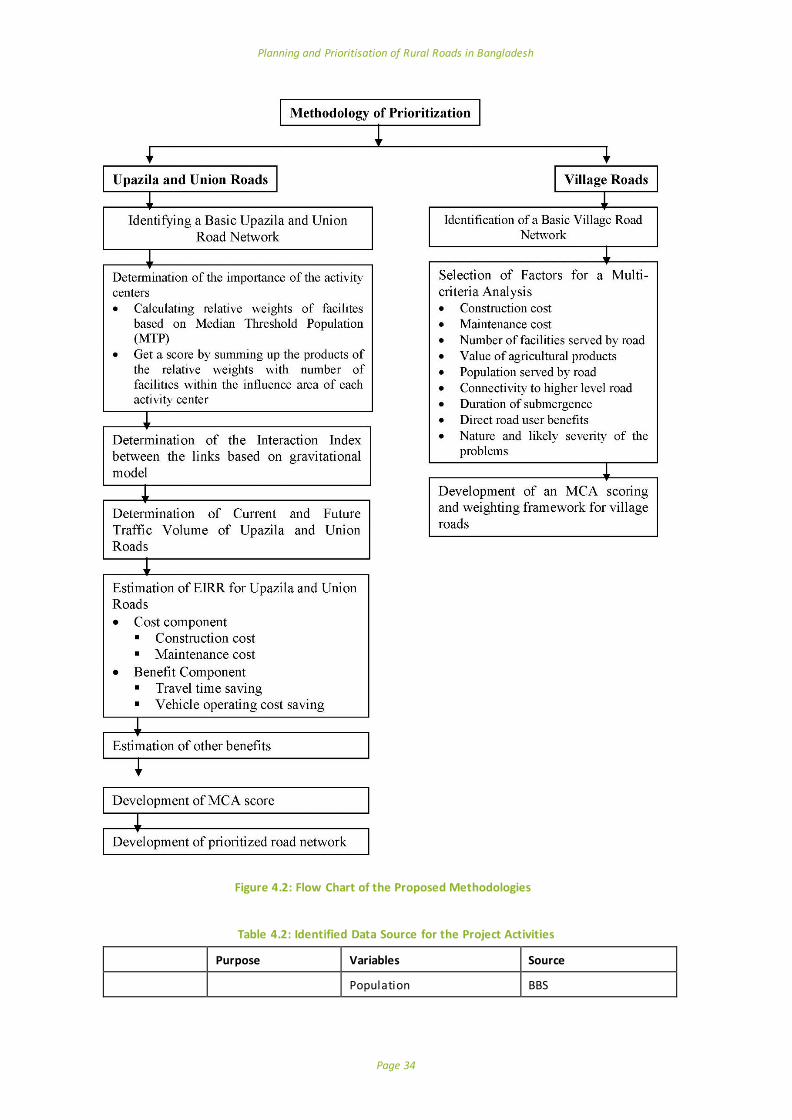
Planning and Prioritisation of Rural Roads in Bangladesh
Page 34
Table 4.2: Identified Data Source for the Project Activities
Purpose Variables Source
Population BBS
Figure 4.2: Flow Chart of the Proposed Methodologies

Planning and Prioritisation of Rural Roads in Bangladesh
Page 35
Upazila and Union Roads
Centrality score of the activity centres
Number of commercial establishments (shops,
agricultural service centre, industry etc.)
LGED and local sources
Number of facil ities (school, college, healthcare centres)
LGED, Field survey
Interaction Index of l inks
Traffic volume LGED, Field survey
AADT Secondary source
Cost Benefit
Analysis
Roughness Index LGED/ BUET (Civil Department)
Travel time cost for passengers
LGED/RHD/GIZ
Travel time cost for vehicles of different types
LGED/RHD/GIZ
Vehicle operating cost saving LGED/RHD/GIZ
Road construction cost LGED
Road maintenance cost LGED
Village Roads
Cost Effectiveness
Road construction cost LGED (Secondary)
Maintenance cost
Population served per km BBS
Connectivity with higher order roads
LGED (Primary Source)
Physical connectivity Number of facil ities served by
the roads
LGED (Primary/Secondary
source)
Agricultural potential Value of agricultural products Primary Source
Passability Number of days the road
under water Primary source
Environmental effects Flooding and drainage effects Primary source
5 Inception Phase
5.1 Meetings with LGED and ReCAP Officials
A total of three meetings have been held: pre-kick off meeting on 4th April, 2016, Kick-off meeting on the 10th April, 2016 and post-kick-off meeting on the 16th April, 2016. All these meetings were very useful to understand the project task and requirement of the client. Particularly the kick -off meeting set the direction of the task and was very helpful to understand each other. Apart from LGED officials, this meeting was attended by ReCAP representatives Mr. Jasper Cook, the Team Leader and
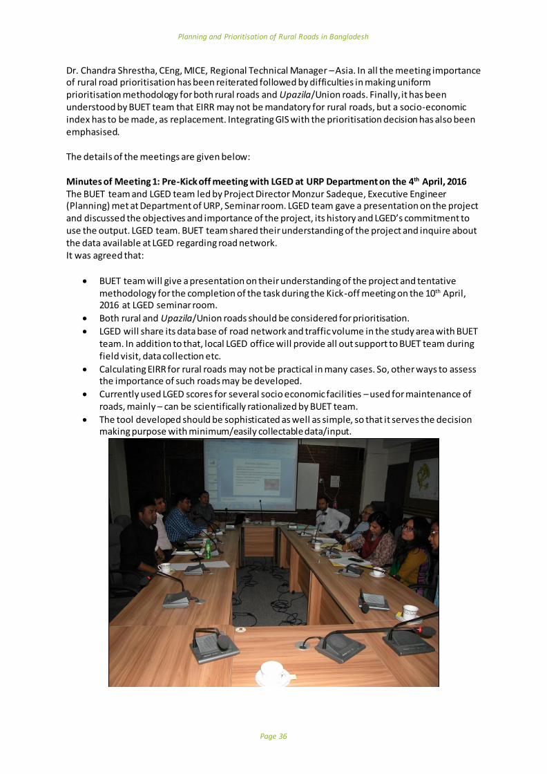
Planning and Prioritisation of Rural Roads in Bangladesh
Page 36
Dr. Chandra Shrestha, CEng, MICE, Regional Technical Manager – Asia. In all the meeting importance of rural road prioritisation has been reiterated followed by difficulties in making uniform prioritisation methodology for both rural roads and Upazila/Union roads. Finally, it has been understood by BUET team that EIRR may not be mandatory for rural roads, but a socio-economic index has to be made, as replacement. Integrating GIS with the prioritisation decision has also been emphasised. The details of the meetings are given below: Minutes of Meeting 1: Pre-Kick off meeting with LGED at URP Department on the 4th April, 2016
The BUET team and LGED team led by Project Director Monzur Sadeque, Executive Engineer (Planning) met at Department of URP, Seminar room. LGED team gave a presentation on the project and discussed the objectives and importance of the project, its history and LGED’s commitment to use the output. LGED team. BUET team shared their understanding of the project and inquire about the data available at LGED regarding road network. It was agreed that:
BUET team will give a presentation on their understanding of the project and tentative methodology for the completion of the task during the Kick-off meeting on the 10th April, 2016 at LGED seminar room.
Both rural and Upazila/Union roads should be considered for prioritisation.
LGED will share its data base of road network and traffic volume in the study area with BUET team. In addition to that, local LGED office will provide all out support to BUET team during field visit, data collection etc.
Calculating EIRR for rural roads may not be practical in many cases. So, other ways to assess the importance of such roads may be developed.
Currently used LGED scores for several socio economic facilities – used for maintenance of roads, mainly – can be scientifically rationalized by BUET team.
The tool developed should be sophisticated as well as simple, so that it serves the decision making purpose with minimum/easily collectable data/input.
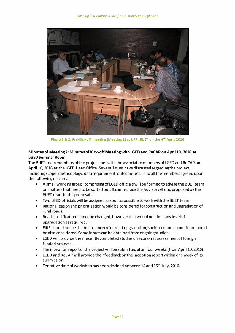
Planning and Prioritisation of Rural Roads in Bangladesh
Page 37
Photo 1 & 2: Pre-Kick-off meeting (Meeting 1) at URP, BUET on the 4th April, 2016
Minutes of Meeting 2: Minutes of Kick-off Meeting with LGED and ReCAP on April 10, 2016 at LGED Seminar Room The BUET team members of the project met with the associated members of LGED and ReCAP on April 10, 2016 at the LGED Head Office. Several issues have discussed regarding the project, including scope, methodology, data requirement, outcome, etc., and all the members agreed upon the following matters:
A small working group, comprising of LGED officials will be formed to advise the BUET team on matters that need to be sorted out. It can replace the Advisory Group proposed by the BUET team in the proposal.
Two LGED officials will be assigned as soon as possible to work with the BUET team.
Rationalization and prioritisation would be considered for construction and upgradation of rural roads.
Road classification cannot be changed, however that would not limit any level of upgradation as required.
EIRR should not be the main concern for road upgradation, socio-economic condition should be also considered. Some inputs can be obtained from ongoing studies.
LGED will provide their recently completed studies on economic assessment of foreign funded projects.
The inception report of the project will be submitted after four weeks (from April 10, 2016).
LGED and ReCAP will provide their feedback on the inception report within one week of its submission.
Tentative date of workshop has been decided between 14 and 16th July, 2016.

Planning and Prioritisation of Rural Roads in Bangladesh
Page 38
Photo 3 & 4: Kick-off meeting at LGED Seminar Room, 10th April, 2016
Minutes of Meeting 3: Post-Kick-off meeting with LGED at Department of URP, BUET on the April 16, 2016
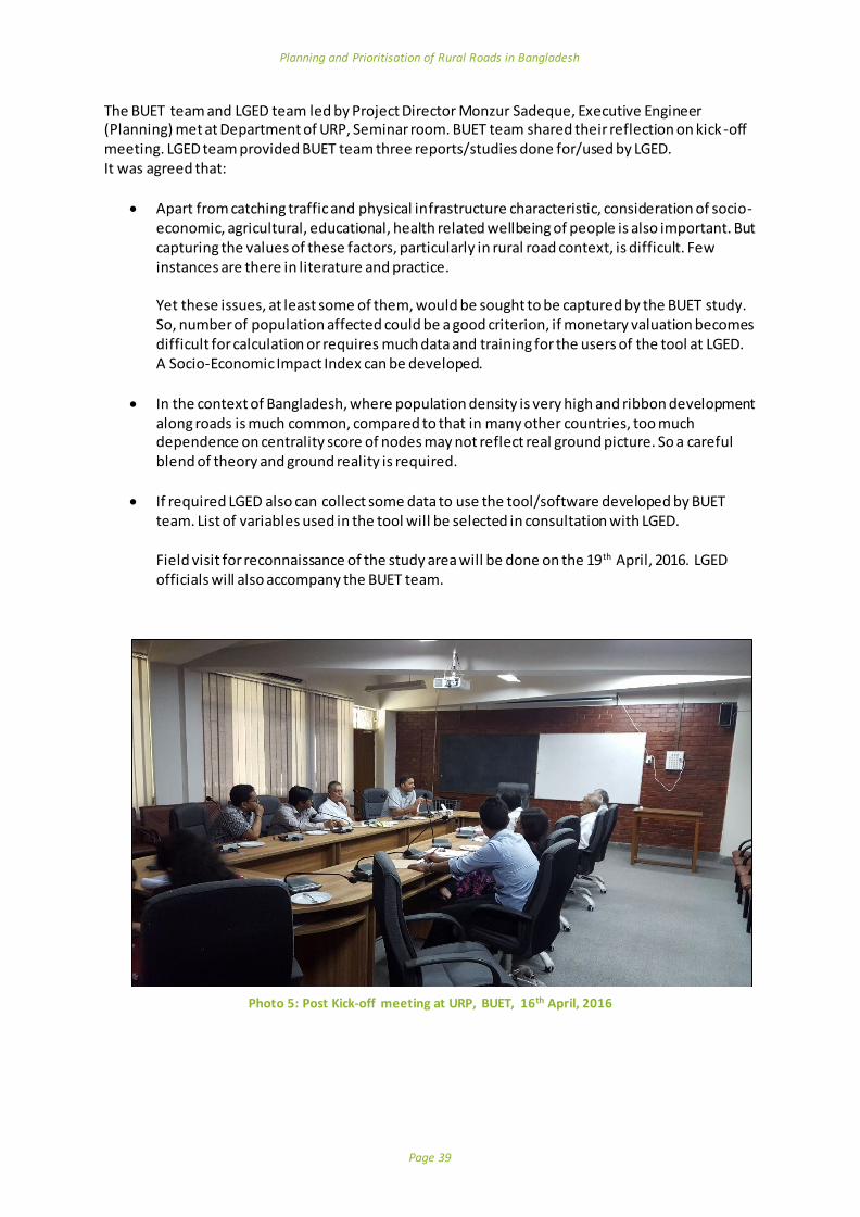
Planning and Prioritisation of Rural Roads in Bangladesh
Page 39
The BUET team and LGED team led by Project Director Monzur Sadeque, Executive Engineer (Planning) met at Department of URP, Seminar room. BUET team shared their reflection on kick-off meeting. LGED team provided BUET team three reports/studies done for/used by LGED. It was agreed that:
Apart from catching traffic and physical infrastructure characteristic, consideration of socio-economic, agricultural, educational, health related wellbeing of people is also important. But capturing the values of these factors, particularly in rural road context, is difficult. Few instances are there in literature and practice. Yet these issues, at least some of them, would be sought to be captured by the BUET study. So, number of population affected could be a good criterion, if monetary valuation becomes difficult for calculation or requires much data and training for the users of the tool at LGED. A Socio-Economic Impact Index can be developed.
In the context of Bangladesh, where population density is very high and ribbon development along roads is much common, compared to that in many other countries, too much dependence on centrality score of nodes may not reflect real ground picture. So a careful blend of theory and ground reality is required.
If required LGED also can collect some data to use the tool/software developed by BUET team. List of variables used in the tool will be selected in consultation with LGED. Field visit for reconnaissance of the study area will be done on the 19th April, 2016. LGED officials will also accompany the BUET team.
Photo 5: Post Kick-off meeting at URP, BUET, 16th April, 2016

Planning and Prioritisation of Rural Roads in Bangladesh
Page 40
5.2 Field Visit
A whole day field visit was conducted by the project team on the 19th April 2016, Tuesday. LGED officials also accompanied the BUET team. In support of the overall aim of the project, the field visit was intended to serve the following purposes:
To know what data and resources are primarily available to the local officials and what can be further managed in collaboration with the key stakeholders.
To get an idea about the existing methodology for prioritisation of the rural roads by the concerned authority at the local level.
To explore the key challenges faced by the local authority for the rural road development projects.
From field visit it has been understood that:
LGED Upazila office can collect data related to shops and activities in rural markets. Last year LGED identified Important Village Roads (IVR) in each Upazila mostly based on
connectivity - the underdeveloped link that could connect two higher order roads.
Upazila agriculture office has important data relating agricultural products, yield etc. at Block level. Each Union is divided into three Blocks, each having 1500-2000 people.
Statistics office has the data collected for official BBS data. Statistics officer informed that they have data up to Village level. In many cases in one Mouza there is only one Village. In such cases Mouza population may be considered as Village population. However, some Mouzas have more than one Village. In that case population of each Village is given in published census report.
Number of users of a Village road can be roughly estimated by Union Secretary with help from three Union members/councillors.
5.2.1 Details of the Field Visit
In this project, Tangail is selected as a sample district to test the methodology for prioritisation of rural roads. The project team met Upazila officials - LGED engineers, agriculture officer, statistics officer, Union secretary, in two Upazilas (Mirzapur and Tangail Sadar) and the District Executive Engineer of Tangail. Mirzapur Upazila, Tangail Upazila assistant engineer Mr. Jagadish Chandra Sarker expressed the existing challenges of prioritisation of rural roads according to the ongoing system where higher order roads (Upazila roads) always receive higher priority for up-gradation, even if at times it becomes more urgent to improve the rural roads which are in dilapidated condition. However, he mentioned about a methodology developed by LGED at the local level for identification of important rural roads (IVR). The officials noted that among numerous roads in rural areas, they identified 36 IVRs for Mirzapur Upazila. Some key factors are to be considered while identifying the IVRs as stated by the officials: connectivity with higher order roads and the facilities like schools, hospitals etc. served by the roads. The engineers informed the project team about the existing inventory of the roads. Data regarding the length of the road, surface types, location of different facilities and their distance from the roads are already available to the officials. LGED has already the existing practice of collecting traffic volume data for Upazila and Union roads. They count number of vehicles according to the types of different modes during the hat days. Hence, the AADT (Average Annual daily traffic) can be provided

Planning and Prioritisation of Rural Roads in Bangladesh
Page 41
by the LGED for different roads as confirmed by the engineers. The roads connecting the important nodes like growth centres, hat/bazaars are important while considering the prioritisation of rural roads. Local officials confirmed that the lease value of different growth centres and hat/bazaars can be collected from the Upazila administrative officials. They also assured that the number of commercial establishments can be collected by the field survey if required for the project.
Photo 6: Field Visit in Mirzapur Upazila LGED Office, Tangail
The statistics officer of Mirzapur ensured about the availability of population data at the Village level according to the census report of BBS. He also stated that the number of people served by a road can be estimated based on the available data to them. Upazila agriculture officer informed us that each Union is divided into 3 blocks and agricultural data (crop production) can be provided by the block supervisors.
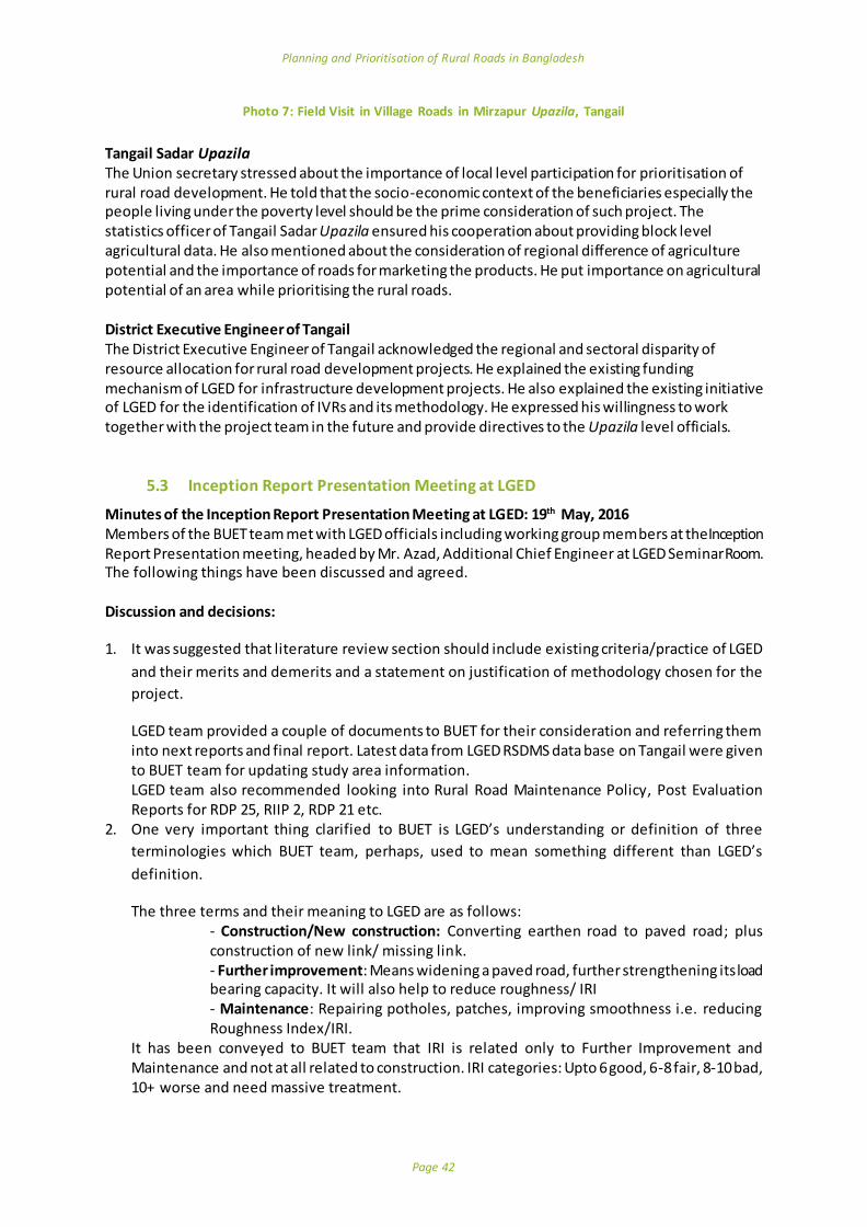
Planning and Prioritisation of Rural Roads in Bangladesh
Page 42
Photo 7: Field Visit in Village Roads in Mirzapur Upazila, Tangail
Tangail Sadar Upazila The Union secretary stressed about the importance of local level participation for prioritisation of rural road development. He told that the socio-economic context of the beneficiaries especially the people living under the poverty level should be the prime consideration of such project. The statistics officer of Tangail Sadar Upazila ensured his cooperation about providing block level agricultural data. He also mentioned about the consideration of regional difference of agriculture potential and the importance of roads for marketing the products. He put importance on agricultural potential of an area while prioritising the rural roads. District Executive Engineer of Tangail The District Executive Engineer of Tangail acknowledged the regional and sectoral disparity of resource allocation for rural road development projects. He explained the existing funding mechanism of LGED for infrastructure development projects. He also explained the existing initiative of LGED for the identification of IVRs and its methodology. He expressed his willingness to work together with the project team in the future and provide directives to the Upazila level officials.
5.3 Inception Report Presentation Meeting at LGED
Minutes of the Inception Report Presentation Meeting at LGED: 19th May, 2016 Members of the BUET team met with LGED officials including working group members at the Inception Report Presentation meeting, headed by Mr. Azad, Additional Chief Engineer at LGED Seminar Room. The following things have been discussed and agreed. Discussion and decisions:
1. It was suggested that literature review section should include existing criteria/practice of LGED
and their merits and demerits and a statement on justification of methodology chosen for the
project.
LGED team provided a couple of documents to BUET for their consideration and referring them into next reports and final report. Latest data from LGED RSDMS data base on Tangail were given to BUET team for updating study area information. LGED team also recommended looking into Rural Road Maintenance Policy, Post Evaluation Reports for RDP 25, RIIP 2, RDP 21 etc.
2. One very important thing clarified to BUET is LGED’s understanding or definition of three
terminologies which BUET team, perhaps, used to mean something different than LGED’s
definition.
The three terms and their meaning to LGED are as follows: - Construction/New construction: Converting earthen road to paved road; plus construction of new link/ missing link. - Further improvement: Means widening a paved road, further strengthening its load bearing capacity. It will also help to reduce roughness/ IRI - Maintenance: Repairing potholes, patches, improving smoothness i.e. reducing Roughness Index/IRI.
It has been conveyed to BUET team that IRI is related only to Further Improvement and Maintenance and not at all related to construction. IRI categories: Upto 6 good, 6-8 fair, 8-10 bad, 10+ worse and need massive treatment.

Planning and Prioritisation of Rural Roads in Bangladesh
Page 43
3. As part of the task BUET team should make prioritization methodology/ tool separately for all
these three tasks – construction, further improvement and maintenance, as LGED is allocated
budget differently for these three tasks; a single methodology will not serve the purpose of LGED.
It was conveyed to BUET team that currently maintenance prioritisation is done based on two criteria: Road parameter (condition, IRI of the road) and District parameter (budget allocated/available).
4. It was agreed that the basis of the task of BUET team will be LGED data based/inventory i.e.
RSDMS. If in case, GIS data and RSDMS differ, RSDMS will be considered to be correct.
5. One important thing conveyed to BUET team is that methodology proposed by them should be
similar and incremental to LGED’s previous practices. A big jump will make the tool ineffective and
leave it unutilized. If the methodology is very ambitious, LGED will not be able to use it.
6. LGED is ready to collect some data, but that should be minimum. If possible, the required data
field can be added to LGED’s database, so that collection of those data becomes part of LGED’s
regular data collection task.
7. At IR, separate methodologies are proposed for Upazila roads (UZR)/ Union roads (UR) and Village
roads (VR). But, for example, it may be mentioned that many village roads in Gazipur, a
neighbouring district of Tangail, have more traffic than many other Upazila/Union roads in many
other Upazilas/Zilas. So, screening procedure in proposed two tiers of methodology should be
based on traffic volume, not administrative classification UZR/UR vs VR. Cut-off point for traffic
volume may be statistically identified.
8. Data on Value of agricultural product is difficult for LGED to collect. This variable should either be
omitted or any other simple variable or proxy variable (like lease value of market) may be
considered.
9. It was suggested to keep in mind that prioritisation should be done of links/roads, not
node/activity centres. But of course, importance of a node/ activity should make impact on the
priority value of a link/road.
Besides, peripheral roads, stretching out to neighbouring upazila, should also be considered.
10. It was requested to BUET team to look into the possibility of having any indicator to reflect political
factor/ interest? Because, in Bangladesh context, whatever objective tool LGED uses, political
factor cannot be over-ruled. Moreover, unless we show that their opinion is also incorporated in
the tool/methodology, politicians will oppose application of the methodology/tool.
11. It is better to avoid Excel based tool; Access based tool is ok, but front end should be in different
language. During the meetings it was agreed that although calculations for prioritisation will be
done in Access and the graphical outputs will be produced by in a GIS environment. If any
proprietary software is going to be used, estimated cost of software needs to be included. If BUET
team develops any new software that is also welcome, as long as it serves LGED’s purpose.
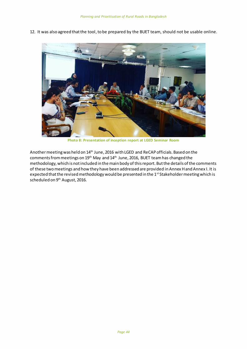
Planning and Prioritisation of Rural Roads in Bangladesh
Page 44
12. It was also agreed that the tool, to be prepared by the BUET team, should not be usable online.
Photo 8: Presentation of inception report at LGED Seminar Room
Another meeting was held on 14th June, 2016 with LGED and ReCAP officials. Based on the comments from meetings on 19th May and 14th June, 2016, BUET team has changed the methodology, which is not included in the main body of this report. But the details of the comments of these two meetings and how they have been addressed are provided in Annex H and Annex I. It is expected that the revised methodology would be presented in the 1st Stakeholder meeting which is scheduled on 9th August, 2016.
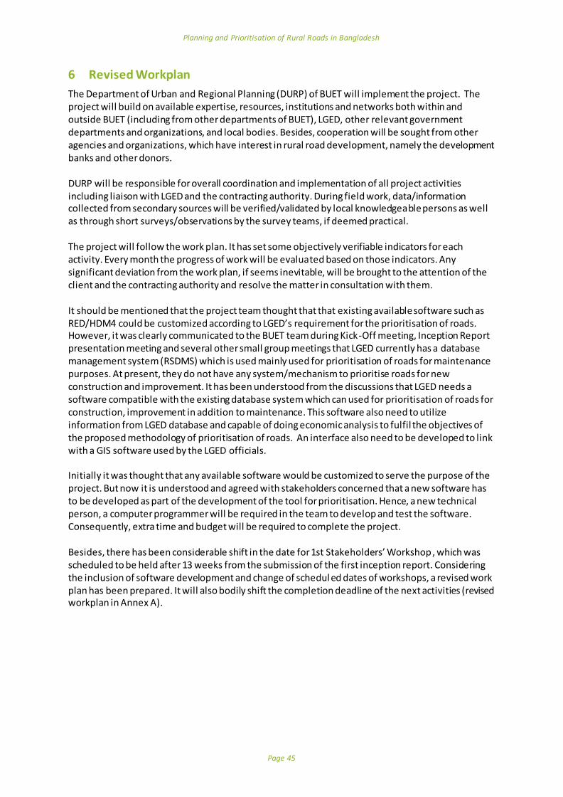
Planning and Prioritisation of Rural Roads in Bangladesh
Page 45
6 Revised Workplan
The Department of Urban and Regional Planning (DURP) of BUET will implement the project. The project will build on available expertise, resources, institutions and networks both within and outside BUET (including from other departments of BUET), LGED, other relevant government departments and organizations, and local bodies. Besides, cooperation will be sought from other agencies and organizations, which have interest in rural road development, namely the development banks and other donors.
DURP will be responsible for overall coordination and implementation of all project activities including liaison with LGED and the contracting authority. During field work, data/information collected from secondary sources will be verified/validated by local knowledgeable persons as well as through short surveys/observations by the survey teams, if deemed practical.
The project will follow the work plan. It has set some objectively verifiable indicators for each activity. Every month the progress of work will be evaluated based on those indicators. Any significant deviation from the work plan, if seems inevitable, will be brought to the attention of the client and the contracting authority and resolve the matter in consultation with them.
It should be mentioned that the project team thought that that existing available software such as RED/HDM4 could be customized according to LGED’s requirement for the prioritisation of roads. However, it was clearly communicated to the BUET team during Kick-Off meeting, Inception Report presentation meeting and several other small group meetings that LGED currently has a database management system (RSDMS) which is used mainly used for prioritisation of roads for maintenance purposes. At present, they do not have any system/mechanism to prioritise roads for new construction and improvement. It has been understood from the discussions that LGED needs a software compatible with the existing database system which can used for prioritisation of roads for construction, improvement in addition to maintenance. This software also need to utilize information from LGED database and capable of doing economic analysis to fulfil the objectives of the proposed methodology of prioritisation of roads. An interface also need to be developed to link with a GIS software used by the LGED officials.
Initially it was thought that any available software would be customized to serve the purpose of the project. But now it is understood and agreed with stakeholders concerned that a new software has to be developed as part of the development of the tool for prioritisation. Hence, a new technical person, a computer programmer will be required in the team to develop and test the software. Consequently, extra time and budget will be required to complete the project.
Besides, there has been considerable shift in the date for 1st Stakeholders’ Workshop , which was scheduled to be held after 13 weeks from the submission of the first inception report. Considering the inclusion of software development and change of scheduled dates of workshops, a revised work plan has been prepared. It will also bodily shift the completion deadline of the next activities (revised workplan in Annex A).

Planning and Prioritisation of Rural Roads in Bangladesh
Page 46
7 Management Approach
DURP will also take the main responsibility for organizing field works, developing the resource materials, conducting the training workshop, maintaining financial records as required by BUET,. DURP will make available physical, technical and other resources required for timely implementation of the project. DURP will prepare an overall work plan, taking into account the mentioned risks and will monitor the progress of project implementation. After discussion with LGED officials and other stakeholders, a mechanism will be put in place to monitor the progress of project implementation and evaluate completed activities. In order to manage timely completion of all activities, a number of steps will be taken. If deemed practical, the preliminary work for achieving each milestone will start earlier than the scheduled time plan. Regular liaison will be maintained with LGED and other stakeholders, so that their inputs and feedbacks are received in a timely manner. Apart from the scheduled workshops, in-house workshops attended by LGED officials and experts will be organized to receive feedback and maintain the quality of work. In order to develop interest in, and ownership of the project among LGED experts, policy makers and other stakeholders, wide consultations will be held with them at different stages of project implementation. They may be invited to participate directly in some of the activities such as developing the criteria of prioritisation and their relative weights. They may also be involved in identifying the priority network in the test case district, as well as in developing a computer programme for the purpose. The pilot district has already been selected in consultation with LGED and other stakeholders. For its selection, among other factors, representativeness of the district, consideration of likely disruption of field work due to natural events and other matters were taken into account. In this project, capacity building combines institution building, and human and technical resource development for rural road development. Information and communication technologies as well as regular contacts and interaction among the trained officials by the project may facilitate further training, knowledge management and sharing of information. Resource materials on rural road prioritisation and other relevant information from the project may be made available to all interested parties subject to the discretion of LGED/client.

Planning and Prioritisation of Rural Roads in Bangladesh
Page 47
8 Technical Inputs and Budget and Inputs
It has already been mentioned in the revised workplan section that a new key person, Computer Programmer should be included in the project team (see section 6 for clarification). Therefore additional cost will be involved and hence total budget of the project is need to be revised. The proposed Computer Programmer requires to give an input for 60 person-days and unit rate is proposed to GBP 230/day. All other team members mentioned in the proposal remain same in terms of length of input and rate of remuneration.

Planning and Prioritisation of Rural Roads in Bangladesh
Page 48
9 Community Access
As a research project, this study would not directly cover community issues like gender, poverty etc. However, these issues will be considered indirectly in the social and environmental criteria of MCA which has been already discussed in the methodology section.

Planning and Prioritisation of Rural Roads in Bangladesh
Page 49
10 M&E Plan
It was agreed at the initial meeting (kick-off meeting) that in order to ensure the quality of project outputs and assist in the implementation process, LGED has establish a Working Group. It will give overall guidance and assistance in implementation of the project, consider the intermediate outputs and may also give necessary advice to the project team as may be required. Questionnaire surveys of meeting/workshop/training course participants and other beneficiaries will be undertaken after holding all such events. User surveys will also be carried out to evaluate the quality of resource materials produced by the project. Feedbacks from the surveys will be used for the improvement and finalization of the training manual and other resource materials. Simple indicators will be used for the purpose of verification of the expected accomplishments by the project. The disbursed fund will be received by the Bureau of Research, Testing and Consultation (BRTC), BUET. BRTC will conduct internal audit to ensure proper utilization of resources, and maintain all financial records as per rules of BUET. An overall substantive self-evaluation is foreseen to take place at the end of the project execution. Resources will be allocated for an expert and other expenses in connection with the evaluation.

Planning and Prioritisation of Rural Roads in Bangladesh
Page 50
11 Risks
The risk associated with the project and the measures of mitigation is provided in a Risk Matrix in Annex D.

Planning and Prioritisation of Rural Roads in Bangladesh
Page 51
Annex A: Updated Workplan
Key –Activity Type
Advisory Input
Milestones
Workshops
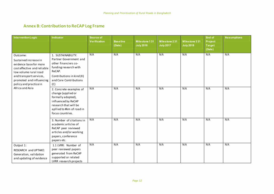
Planning and Prioritisation of Rural Roads in Bangladesh
Page 52
Annex B: Contribution to ReCAP Log Frame
Intervention Logic Indicator Source of
Verification Baseline
(Date)
Milestone 1 31
July 2016
Milestone 2 31
July 2017
Milestone 3 31
July 2018
End of
Project
Target
(Date)
Assumptions
Outcome:
Sustained increase in
evidence base for more cost effective and reliable low volume rural road and transport services,
promoted and influencing policy and practice in Africa and Asia
1. SUSTAINABILITY: Partner Government and
other financiers co-funding research with ReCAP.
Contributions in kind (K)
and Core Contributions (C)
N/A N/A N/A N/A N/A N/A N/A
2. Concrete examples of change (applied or formally adopted),
influenced by ReCAP research that will be apllied to #km of road in
focus countries.
N/A N/A N/A N/A N/A N/A N/A
3. Number of citations in academic articles of ReCAP peer reviewed articles and/or working
papers, conference papers etc.
N/A N/A N/A N/A N/A N/A N/A
Output 1:
RESEARCH and UPTAKE:
Generation, validation and updating of evidence
1.1 LVRR: Number of peer reviewed papers
generated from ReCAP supported or related LVRR research projects
N/A N/A N/A N/A N/A N/A N/A
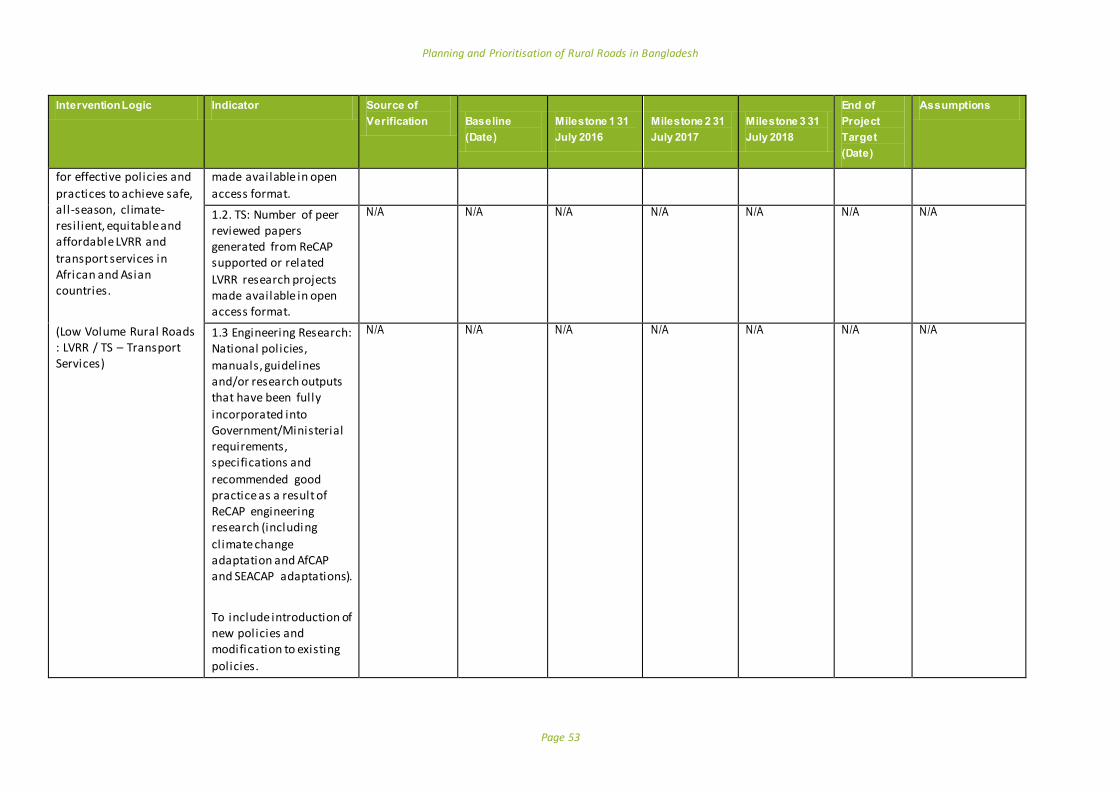
Planning and Prioritisation of Rural Roads in Bangladesh
Page 53
Intervention Logic Indicator Source of
Verification Baseline
(Date)
Milestone 1 31
July 2016
Milestone 2 31
July 2017
Milestone 3 31
July 2018
End of
Project
Target
(Date)
Assumptions
for effective policies and
practices to achieve safe, all-season, climate-resil ient, equitable and affordable LVRR and
transport services in African and Asian countries.
(Low Volume Rural Roads : LVRR / TS – Transport Services)
made available in open
access format.
1.2. TS: Number of peer reviewed papers generated from ReCAP supported or related
LVRR research projects made available in open access format.
N/A N/A N/A N/A N/A N/A N/A
1.3 Engineering Research: National policies,
manuals, guidelines and/or research outputs that have been fully
incorporated into Government/Ministerial requirements, specifications and
recommended good practice as a result of ReCAP engineering research (including
climate change adaptation and AfCAP and SEACAP adaptations).
To include introduction of new policies and modification to existing
policies.
N/A N/A N/A N/A N/A N/A N/A

Planning and Prioritisation of Rural Roads in Bangladesh
Page 54
Intervention Logic Indicator Source of
Verification Baseline
(Date)
Milestone 1 31
July 2016
Milestone 2 31
July 2017
Milestone 3 31
July 2018
End of
Project
Target
(Date)
Assumptions
1.4 TRANSPORT SERVICES
Research: National policies, regulations and/or practices for rural transport services
modified or introduced as a result of ReCAP research (including road
safety and gender and AFCAP and SEACAP research )
To include introduction of new policies and modification to existing policies.
N/A N/A N/A N/A N/A N/A N/A
1.6. LVRR and TS
information generated for dissemination, and disseminated, that is not
peer reviewed. Total to include research papers, final research reports, workshop reports,
manuals and guidelines.
N/A N/A N/A N/A N/A N/A N/A
Output 2:
CAPACITY BUILDING: The building of sustainable capacity to carry out
research on low volume rural roads, and rural
2.1. African / Asian experts or institutions taking lead roles in ReCAP Research Projects.
Contract Document
0 1 1 1 1
2.3. Research projects
with female researcher
Project Documents of the University
0 2 2 2 2

Planning and Prioritisation of Rural Roads in Bangladesh
Page 55
Intervention Logic Indicator Source of
Verification Baseline
(Date)
Milestone 1 31
July 2016
Milestone 2 31
July 2017
Milestone 3 31
July 2018
End of
Project
Target
(Date)
Assumptions
transport services in
African and Asian countries.
inputs at senior technical
level.
Output 3:
KNOWLEDGE: Generated evidence base of LVRR
and transport services knowledge is widely disseminated and easily accessible by policy
makers and practitioners (including education and training institutions).
3.2. ReCAP generated knowledge presented and discussed at high
level international development debates and conferences
N/A N/A N/A N/A N/A N/A N/A
3.3. ReCAP generated knowledge disseminated
through significant workshops and dedicated training, virtually or
physically, that are rated by participants as effective.
Workshop report Final project report Copies of certificates awarded to trainees Questionnaire survey of workshop participants
0 0 15 15 15 LGED timely nominates suitable officials with necessary background for the training, and provides necessary administrative and logistics support as required Nominated officials take interest in the training and acquiring skills to use the new tool

Planning and Prioritisation of Rural Roads in Bangladesh
Page 56
NOTES ON CALCULATION OF ReCAP LOGFRAME INDICATORS FOR SERVICE PROVIDER REPORTING (Ver 22 March 2016)
Outcome 1
SUSTAINABILITY: Partner Government and other financiers co-funding research with ReCAP.
Contributions in kind (K) and Core Contributions (C) to RECAP research are to be recorded by Service Providers. Contribution in kind (K) relates to funding of trial sections, staff time, dissemination and training. Core contributions (C ) relates to funding of research programme core costs, research contracts, capacity building and knowledge management. In kind contributions are to be calculated as follows:
Trial Sections: The full value of the trial section is to be calculated as a partner contribution. For a trial section to be counted against this indicator the value counted must have been constructed during the reporting period. If the value covers preceding reporting periods that must be made clear. E.g A trial section to the value of £1.5m constructed over the past year was completed during the reporting period. Trial sections can only be counted once, so if a trial section was constructed under AFCAP or prior to RECAP it cannot be counted as a partner contribut ion under RECAP.
Training: Where partners provide training costs such as training venues, meals, refreshments, training materials, and other in-kind support to training an estimate of the in-kind cost is to be made utilising reasonable local commercial rates for a comparable venue. The basis for the calculation should be made clear. E.g. A training venue was provided for 5 days for 22 participants and three trainers, including morning and afternoon tea, and lunch. This is a total of 125 training days, at an assumed local rate of GBP25 per participant per day, for a total of GBP3, 125. Training Materials were provided at an estimated cost of GBP100.
Staff time: Estimated number of days of partner government personnel participating directly in the ReCAP contract should be calculated. To determine an in-kind value a daily rate should be determined using the average gross salary for the country. (Source should be quoted). Annual salaries should be divided by 232 to get a daily rate, monthly rates by 19.3 to get a daily rate.
Any other in-kind costs that partner governments contribute to a ReCAP project should be recorded, and the basis for the calculation recorded.
Core contributions are to where a partner government funds directly, or causes to be funded directly, research programme core costs, research contracts, capacity building and knowledge management. Where these budgets are known supporting documentation should be obtained. (Government budgets, world bank funding etc.). Where it is not possible to get detailed budget documentation a reasonable estimate should be used and the basis recorded. In all cases, in Kind and Core, the estimated % amount being funded by partner governments, both in-kind and directly, should be reported.

Planning and Prioritisation of Rural Roads in Bangladesh
Page 57
If contributions are made in a currency other than GBP, which is likely, the currency should be converted to GBP using the Financial Time rates of the Friday prior to initial date of report submission and foot noted as such.
Outcome 2
Concrete examples of change (applied or formally adopted), influenced by ReCAP research that will be applied to #km of road in focus countries.
Km of road influenced incorporates road programmes that are planned and designed based on ReCAP guidelines. Implementation does not necessarily have to occur during lifespan of ReCAP. The road programmes must be announced, and funded. The service provider must be able to demonstrate that the particular manual, policy, etc. has been formally incorporated into government procedures and will influence the road programmes.
Outcome 3
Number of citations in academic articles of ReCAP peer-reviewed articles and/or working papers, conference papers etc. At the Completion of any project that has included published peer review papers, the Service Provider should collate all citations in academic articles at the time of project completion using Google Scholar (or similar source).
Output 1: Research and Uptake
Generation, validation and updating of evidence for effective policies and practices to achieve safe, all -season, climate-resilient, equitable and affordable LVRR and transport services in African and Asian countries
Output 1.1
LVRR: Number of peer reviewed papers generated from ReCAP supported or related LVRR research projects made available in open access format.
Peer reviewed papers are defined as published in peer reviewed journals, and peer-reviewed conference papers. Service Providers should report in their progress reports when papers are submitted to peer review journals, and when they are published. If there are costs associated with publishing in open access format that are not budgeted Service Providers are to liaise with ReCAP.
Output 1.2
TS: Number of peer reviewed papers generated from ReCAP supported or related Transport Services research projects made available in open access format.
Peer reviewed papers are defined as published in peer reviewed journals and peer-reviewed conference papers. Service Providers should report in their progress reports when papers are submitted to peer review journals, and when they are published.

Planning and Prioritisation of Rural Roads in Bangladesh
Page 58
Output 1.3
Engineering Research: National policies, manuals, guidelines and/or research outputs that have been fully incorporated into Government/Ministerial requirements, specifications and recommended good practice as a result of ReCAP engineering research (including climate change adaptation and AfCAP and SEACAP adaptations).
Notes: These must be formally adopted into Government policies etc. ‘In principle’ agreements do not count. Service providers should detail on what basis they are claiming that adoption has taken place and provide documentary evidence.
Output 1.4
TRANSPORT SERVICES Research: National policies, regulations and/or practices for rural transport services modified or introduced as a result of ReCAP research (including road safety and gender and AFCAP and SEACAP research)
Notes: These must be formally adopted into Government policies etc. ‘In principle’ agreements do not count. Service providers should detail on what basis they are claiming that adoption has taken place and provide documentary evidence.
Output 1.5 Not applicable to Service Providers.
Output 1.6
LVRR and TS information generated for dissemination, and disseminated, that is not peer reviewed.
Service provides are to provide copies of all research papers, final research reports, workshop reports, manuals, guidelines and advocacy materials as part of regular reporting.
Output 2: Capacity Building The building of sustainable capacity to carry out research on low volume rural roads, and rural transport services in African and Asian countries.
Output 2.1
Research capacity: Proportion of research projects undertaken by country-based African/ Asian experts or institutions in lead/management roles;
Service Providers to detail individuals and institutions in lead research and/or management roles.
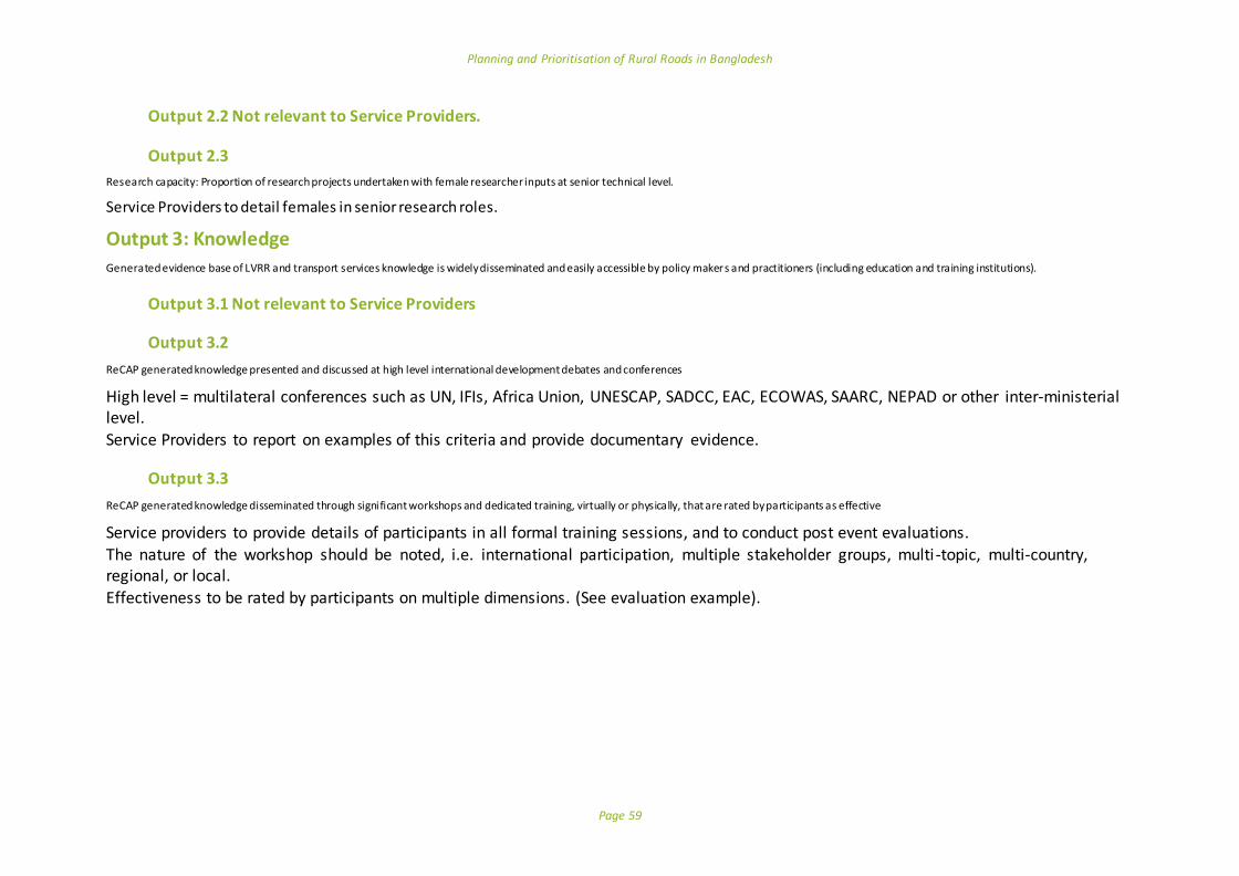
Planning and Prioritisation of Rural Roads in Bangladesh
Page 59
Output 2.2 Not relevant to Service Providers.
Output 2.3
Research capacity: Proportion of research projects undertaken with female researcher inputs at senior technical level.
Service Providers to detail females in senior research roles.
Output 3: Knowledge
Generated evidence base of LVRR and transport services knowledge is widely disseminated and easily accessible by policy makers and practitioners (including education and training institutions).
Output 3.1 Not relevant to Service Providers
Output 3.2
ReCAP generated knowledge presented and discussed at high level international development debates and conferences
High level = multilateral conferences such as UN, IFIs, Africa Union, UNESCAP, SADCC, EAC, ECOWAS, SAARC, NEPAD or other inter-ministerial level. Service Providers to report on examples of this criteria and provide documentary evidence.
Output 3.3
ReCAP generated knowledge disseminated through significant workshops and dedicated training, virtually or physically, that are rated by participants as effective
Service providers to provide details of participants in all formal training sessions, and to conduct post event evaluations. The nature of the workshop should be noted, i.e. international participation, multiple stakeholder groups, multi-topic, multi-country, regional, or local. Effectiveness to be rated by participants on multiple dimensions. (See evaluation example).
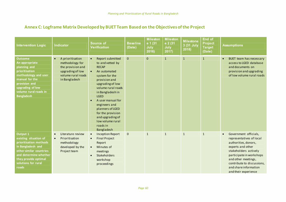
Planning and Prioritisation of Rural Roads in Bangladesh
Page 60
Annex C: Logframe Matrix Developed by BUET Team Based on the Objectives of the Project
Intervention Logic Indicator Source of
Verification
Baseline
(Date)
Mileston
e 1 (31
July
2016)
Mileston
e 2 (31
July
2017)
Milestone
3 (31 July
2018)
End of
Project
Target
(Date)
Assumptions
Outcome An appropriate
planning and prioritisation methodology and user manual for the
provision and upgrading of low volume rural roads in
Bangladesh
A prioritisation
methodology for the provision and
upgrading of low volume rural roads in Bangladesh
Report submitted
to and vetted by RECAP
An automated
system for the provision and upgrading of low volume rural roads
in Bangladesh in LGED
A user manual for
engineers and planners of LGED
for the provision and upgrading of low volume rural
roads in Bangladesh
0 0 1 1 1 BUET team has necessary
access to LGED database and documents on
provision and upgrading of low volume rural roads
Output 1
existing situation of prioritisation methods in Bangladesh and
other similar countries and determine whether they provide optimal solutions for rural
roads
Literature review
Prioritisation
methodology
developed by the Project team
Inception Report
Final Project
Report
Minutes of
meetings Stakeholders
workshop proceedings
0 1 1 1 1 Government officials,
representatives of local
authorities, donors, experts and other stakeholders actively
participate in workshops and other meetings, contribute to discussions, and share information
and their experience
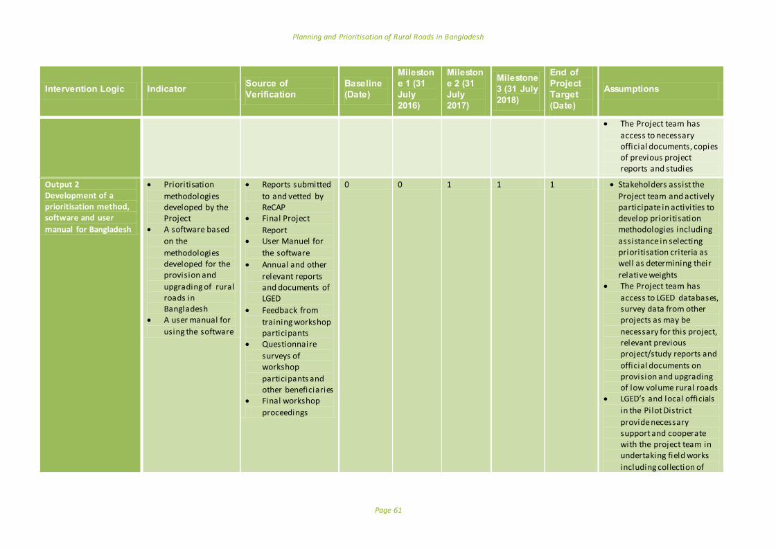
Planning and Prioritisation of Rural Roads in Bangladesh
Page 61
Intervention Logic Indicator Source of
Verification
Baseline
(Date)
Mileston
e 1 (31
July
2016)
Mileston
e 2 (31
July
2017)
Milestone
3 (31 July
2018)
End of
Project
Target
(Date)
Assumptions
The Project team has
access to necessary official documents, copies of previous project reports and studies
Output 2 Development of a prioritisation method, software and user
manual for Bangladesh
Prioritisation
methodologies developed by the Project
A software based
on the
methodologies developed for the provision and
upgrading of rural roads in Bangladesh
A user manual for
using the software
Reports submitted
to and vetted by ReCAP
Final Project
Report User Manuel for
the software
Annual and other
relevant reports and documents of LGED
Feedback from
training workshop participants
Questionnaire
surveys of workshop
participants and other beneficiaries
Final workshop
proceedings
0 0 1 1 1 Stakeholders assist the
Project team and actively participate in activities to develop prioritisation methodologies including
assistance in selecting prioritisation criteria as well as determining their
relative weights The Project team has
access to LGED databases, survey data from other projects as may be
necessary for this project, relevant previous project/study reports and
official documents on provision and upgrading of low volume rural roads
LGED’s and local officials
in the Pi lot District
provide necessary support and cooperate with the project team in undertaking field works
including collection of

Planning and Prioritisation of Rural Roads in Bangladesh
Page 62
Intervention Logic Indicator Source of
Verification
Baseline
(Date)
Mileston
e 1 (31
July
2016)
Mileston
e 2 (31
July
2017)
Milestone
3 (31 July
2018)
End of
Project
Target
(Date)
Assumptions
information and application of the developed tool
LGED nominates two
counterpart officials to
work with the Project team and they participate in works undertaken by
the Project team
Output 3 15 trained
professionals in the use of the planning and prioritisation tool
Training Workshop
Conducted Number of Trained
professionals
Workshop report
Final project report
Copies of
certificates awarded to
trainees Questionnaire
survey of workshop participants
0 0
0 0
1 15
1 15
1 15
LGED timely nominates
suitable officials with necessary background for
the training, and provides necessary administrative and logistics support as
required Nominated officials take
interest in the training and acquiring skills to use the new tool
LGED spends a considerable amount of resources for the improvement of rural roads in Bangladesh. Except for road maintenance purpose, LGED does not have any systematic process in place or a tool is available to prioritise roads for improvement or further improvement (upgrading). The selection of roads from a large number of candidate roads does not follow a rational selection process. LGED has a set of criteri a for prioritisation, however. These include classification
of roads, surface type, physical gaps, traffic volume, funding source, and existence of facil ities along a road such as markets, hospitals, social centres, educational centres and industry. Some of which are used in a scoring framework to prioritise rural roads for maintenance. However, the selection of these criteria, especially assignment of weights to
calculate scores may not have been based on a rational basis.
Precondition

Planning and Prioritisation of Rural Roads in Bangladesh
Page 63
Annex D: Risk Matrix
Programme Risk Assessment and Mitigation Matrix Very High High Medium Low
Potential Risk Risk Grading5
Description of risk Proposed Management and mitigation actions Probability Impact
A. Programme Management Risks
A1:Implementation delays due to hazards / risks at country level
M M
A number of natural and man- made hazards and socio-political unrest may affect the project. However both the probability and impact of these potential risks are l ikely to be medium
Additional effort will be made, in case of any such event, to overcome the lost time. Utmost care will be undertaken to ensure the safety and security of the team members, participants in the workshops and other stakeholders concerned at all times and in all circumstances.
A2: Financial fraud L L
DURP will be responsible for ensuring the sound financial management of the programme. This will be overseen by Team Leader and Coordinator/ Contract Person, reporting to BUET, LGED and ReCAP. Established strong financial management and monitoring systems and practices which will be tailored for use within the project. These measures will include: - No advance payments to suppliers - Payments of expenses against original third party receipts - Payments of fees against timesheets countersigned by the Coordinator/Contract Person of the project - Payment of suppliers consistent with sub-contracts - Periodic independent audits of the Programme Funds
B. Risks associated with Research
B1. Support for Data Collection and Quality of Data
L L
Policy makers, elected officials, officials of the related government departments and other stakeholders take interest in participating in project activities. The quality of data and information received from LGED, other government departments and from local sources can affect the quality of the work.
Adequate measure will be taken for active participation of these stakeholders in workshops/meetings, field works, consultations. Their views will be judged according to their relative weights/importance. The interviewees/observers/commentators will be adequately informed about the nature and scope of the project and measures will be taken for timely input from them including data and other secondary source materials and information from concerned authorities.
5Probability = the likelihood of this risk occurring despite the management and mitigation activities being in place. Impact: = the effect on the ability of the programme to achieve
its objectives without major revision or review.

Planning and Prioritisation of Rural Roads in Bangladesh
Page 64
Programme Risk Assessment and Mitigation Matrix Very High High Medium Low
Potential Risk Risk Grading5
Description of risk Proposed Management and mitigation actions Probability Impact
B2. Scheduled feedback and funding
L L Delay in receiving feedbacks and release of fund may affect the timely achievement of the milestone.
Research team will maintain continuous contact with LGED and ReCAP.

Planning and Prioritisation of Rural Roads in Bangladesh
Page 65
Annex E: References
Ahmed, R. and Hossain, M. 1990. Development Impact of Rural Infrastructure in Bangladesh. Research Report
83, International Food Policy Research Institute (IFPRI) in collaboration with Bangladesh Institute of
Development Studies (BIDS).
Airey, A. 2014. Good Policies and Practices on Rural Transport in Africa: Monitoring and Evaluation. Working Paper no. 99, Sub-Saharan Africa Transport Policy Program.
Archondo-Callao, R. 2004. The Roads Economic Decision Model (RED) for the Economic Evaluation of Low Volume Roads - Software User Guide & Case Studies, SSATP Working Paper No. 78, World Bank.
Archondo-Callao, R. 1999. Roads Economic Decision Model (RED) for economic evaluation of low volume roads. Sub-Saharan Africa Transport Policy Program (SSATP) technical note; no. 18. Washington, DC:
World Bank.
Asian Institute of Transport Development. 2011. Socio-economic Impact of National Highway on Rural Population, New Deli, India.
Azad, A. K. 2016. Speech at the Inception Report Presentation Meeting at LGED Auditorium, 19 th May 2016
BBS. 2015. Zila Report: Tangail, Bangladesh Population and Housing Census 2011, Bangladesh Bureau of Statistics, Statistics and Informatics Division, Ministry of Planning, Government of the People’s Republic of Bangladesh.
BBS. 2013. District Statistics 2011: Tangail , Bangladesh Bureau of Statistics, Statistics and Informatics Division, Ministry of Planning, Government of the People’s Republic of Bangladesh.
BBS. 2012. 2012 Statistical Yearbook of Bangladesh, Bangladesh Bureau of Statistics, Statistics and Informatics Division, Ministry of Planning, Government of the People’s Republic of Bangladesh.
Benmaamar, M. 2003. A Method for the Appraisal of Low Volume Roads in Tanzania. Paper for the XXII PIARC World Road Congress, Durban
Bhandari, S.B., Shahi ,P.B. and Shrestha, R.N. 2014. Multi-criteria evaluation for ranking of rural road projects:
Case study of Nepal , IOSR Journal of Mechanical and Civil Engineering, vol 11, issue 6, pp. 53-65.
Donnges, C. 2001. Rural transport and local government units: how to improve rura l transport for the rural poor?, Transport and Communications Bulletin for Asia and Pacific, No. 71, pp. 19 -27, available from: www.unescap.org/ttdw/Publications/TPTS_pubs/TxBulletin_71/bulletin71_c.pdf.
ESCAP. 1979a. Feeder Road Appraisal, in Report on Seminar cum Study Tour on Economic and Technical Aspects of the Construction of Local Roads and Rural Transport, United Nations, Bangkok, pp. 285 – 294.
ESCAP. 1979b. Guidelines for Rural Centre Planning, United Nations, New York.
GIZ. 2014. Improving Rural Transport Infrastructure: Experience from Bangladesh – An overview on the Rural Infrastructure Improvement Project (RIIP -1).
GTZ. 2009. Road User Cost Study For LGED Roads, Final Report, Rural Infrastructure Improvement Project (RIIP)
RDP-25, Institutional Support and Training Component, Ministry of Local Government, Rural Development and Cooperatives, Government of Bangladesh.
GoB. 2005. Road Design Standards - Rural Road. Dhaka: GoB.
Greenstein, J. and Bonjack, H. 1983. Socio-economic evaluation and upgrading of rural roads in agricultural
areas of Ecuador. Proceedings of the 3rd Low Volume Roads Conference. Transportation Research Record 898, pp 88-94.
Guhnemann, A., Laird, J. J. and Pearman, A.D. 2012. "Combining cost-benefit and multi -criteria analysis to
prioritise a national road infrastructure programme", Transport Policy, vol 23, no. 1, pp. 15 -24.
Haggett, P., and Gunawardena, K. A. 1964. Determination of Population Thresholds for Settlement Functions by the Reed-Muench Method. The Professional Geographer, 6-9.
Hiep, V. D. 2006. HDM-4,dTIMS-CT, &HERST Tools for Asset Management, Saitama University, Available at
http://www.academia.edu/1734546/Comparison_between_HDM-4_dTIMS-CT_and_HERS-ST_Tools_for_Asset_Management accessed on 29th April 2016
Hine, J., Simon, E., Done, S. and David, K. 2003. Ghana Feeder Road Prioritisation.

Planning and Prioritisation of Rural Roads in Bangladesh
Page 66
Kharate, V. B. 2008. Hierarchical Patterns of Rural Central places in the Painganga Valley, International Research Journal , vol II (5), pp. 471-474.
Khan, S. and Ahmad, A. 2013. Hierarchy of Rural Settlements: A Strategy for Balanced Regional Development in Aligarh District, International Journal of Scientific Research, vol. 2(9), pp. 194-197.
Kumar, A. and Kumar, P. 1999. User friendly model for planning rural road, Transportation Research Record, vol. 1652, pp. 31-39.
Lebo, J. and Schelling, D. 2001. Design and Appraisal of Rural Transport Infrastructure, Ensuring Basic Access for the Rural Communities, Technical Paper No 496, World Bank, Washington, USA.
LGED. 2016. Road Database, Local Government Engineering Department, Local Government Division, Ministry of Local Government, Rural Development and Cooperatives. Website: http://www.lged.gov.bd/
LGED. 2010. Planning Guidelines for Rural Road Master Plan (Guideline on GIS Application for Rural Road
Development.
LGED. 2009X. Results of Terminal Surveys on Benefit Monitoring and Evaluation, Final Report, Volume 1, Rural Infrastructure Improvement Project (RIIP), Rural Development Project (RDP)-25, August 2009.
LGED. 2004. Feasibility Study on Sylhet Division Rural Infrastructure Development Project (SDRIDP): Draft Final
Report, Government of Bangladesh.
LGED. 2002. Regional Road Network Study for Prioritisation under RRMIMP-II, Final Report, prepared for LGED by DHV Consultants, The Netherlands, DEVCONsultants Limited, SARM Associates Ltd. and Design
Consultants Ltd.
LGRDC. 2013. Guidelines for Rural Roads and Culverts Maintenance, Local Government Division, Ministry of Local Government, Rural Development and Cooperatives, Government of Bangladesh.
Lombard, P. and Coetzer, L. 2007.The estimation of the impact of rural road investments on socio-economic
development.
Oudheusden, D. L. and Khan, L. R. 1987. Planning and development of rural road networks in developing countries, European Journal of Operational Research, vol. 32-3, pp. 353–362.
Philippine Rural Development Project.2015. The I-BUILD Operations Manual.
Planning Commission. 2015. The Seventh Five Year Plan: FY2016-FY2020, Government of Bangladesh.
Planning Commission. 2005. Project Appraisal Framework: Road Sector Manual, Planning Commission, Government of Bangladesh.
Rahim, S. A. 2016. Speech at the Inception Report Presentation Meeting at LGED Auditorium, 19 th May 2016 and Observations made during several meeting between BUET team and LGED counterpart
Rahman, K. U. and Noor, S. 2005. Central Functions and Centrality in Rural Settlements of Sargodha District, Pakistan Geographical Review, vol. 60(2), pp. 70-79.
Sarker, A. K. and Dash, M. 2011. Quantifications of accessibility and prioritisation of Vil lages for local level planning, Transport and Communications Bulletin, No. 81, pp.1-22.
Singh, A. K. 2010. GIS Based Rural Road Network Planning for Developing Countries, Journal of Transportation Engineering, Available at: http://dx.doi.org/10.1061/(ASCE)TE.1943-5436.0000212.
Shakhawat, H. 2016. Speech at the Inception Report Presentation Meeting at LGED Auditorium, 19 th May 2016 and Observations made during several meeting between BUET team and LGED counterpart
Shrestha, C. B. 2003. Developing a computer-aided methodology for district road network planning and
prioritisation in Nepal, Transportation Research Board, vol. 3, pp. 157-174.
Shrestha, J.K., Benta, A. and Lopes, R.B. and Lopes, N. 2013. A Methodology for Definition of Road Networks in Rural Areas of Nepal , International Journal of Civil, Environmental, Structural, Construction and Architectural Engineering, vol. 7, No. 6, pp. 422-426.
Squire, L. and Van der Tak, H.G. 1975. Economic analysis of projects. London, The Johns Hopkins University Press.
UNCHS. 1985. Guidelines for the Planning of Rural Settlements and Infrastructure: Road Networks. Nairobi,
Kenya.
World Bank. 2008. HDM 4 – Introduction (Powerpoint Slides) Available at http://web.worldbank.org/WBSITE/EXTERNAL/TOPICS/EXTTRANSPORT/EXTROADSHIGHWAYS/0,,conte

Planning and Prioritisation of Rural Roads in Bangladesh
Page 67
ntMDK:22011461~pagePK:148956~piPK:216618~theSitePK:338661,00.html#downloads accessed on 29th April 2016
World Bank. 2003. Toolkit for the Economic Evaluation of World Bank Transport Projects. World Bank, Washington D.C., USA.
Yedla, S. and Shrestha, R.M. 2003. Multi-criteria approach for the selection of alternative options for environmentally sustainable transport system in Delhi. Transportation Research Part A: Policy and Practice, 37(8), pp.717–729.
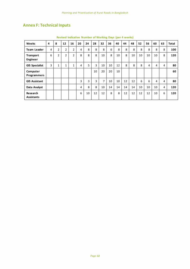
Planning and Prioritisation of Rural Roads in Bangladesh
Page 68
Annex F: Technical Inputs
Revised Indicative Number of Working Days (per 4 weeks)
Weeks 4 8 12 16 20 24 28 32 36 40 44 48 52 56 60 63 Total
Team Leader 4 2 2 2 4 8 8 8 6 8 8 8 8 8 8 8 100
Transport
Engineer
6 2 2 2 8 8 8 10 8 10 8 10 10 10 10 8 120
GIS Specialist 3 1 1 1 4 5 3 10 10 12 8 8 8 4 4 4 80
Computer Programmers
10 20 20 10 60
GIS Assistant 3 3 3 7 10 10 12 12 6 6 4 4 80
Data Analyst 4 8 8 10 14 14 14 14 10 10 10 4 120
Research Assistants
6 10 12 12 8 8 12 12 12 12 10 6 120

Planning and Prioritisation of Rural Roads in Bangladesh
Page 69
Annex G: Revised Budget
Revised Remuneration – Fees for experts
The remuneration of experts is filled in the following table:
Expert Input (number of
days)
Unit rate (GBP) per day Total (GBP)
Team Leader 100 400 40,000
Transport Engineer 120 230 27,600
GIS Specialist 80 230 18,400
Computer Programmer 60 230 13,800
GIS Assistant 80 80 6,400
Data Analyst 120 80 9,600
Research Assistant (2) 120 50 6,000
Total Remuneration 1,218,000
Incidental Expenditures
Description Quantity Unit rate (GBP) Total (GBP)
Workshops 2 2,750 5,500
Data collection Several times Lump sum 2,000
ToT training 1 4,500 4,500
Total Incidental Expenditures
12,000
Total Revised Budget: GBP 133,800.
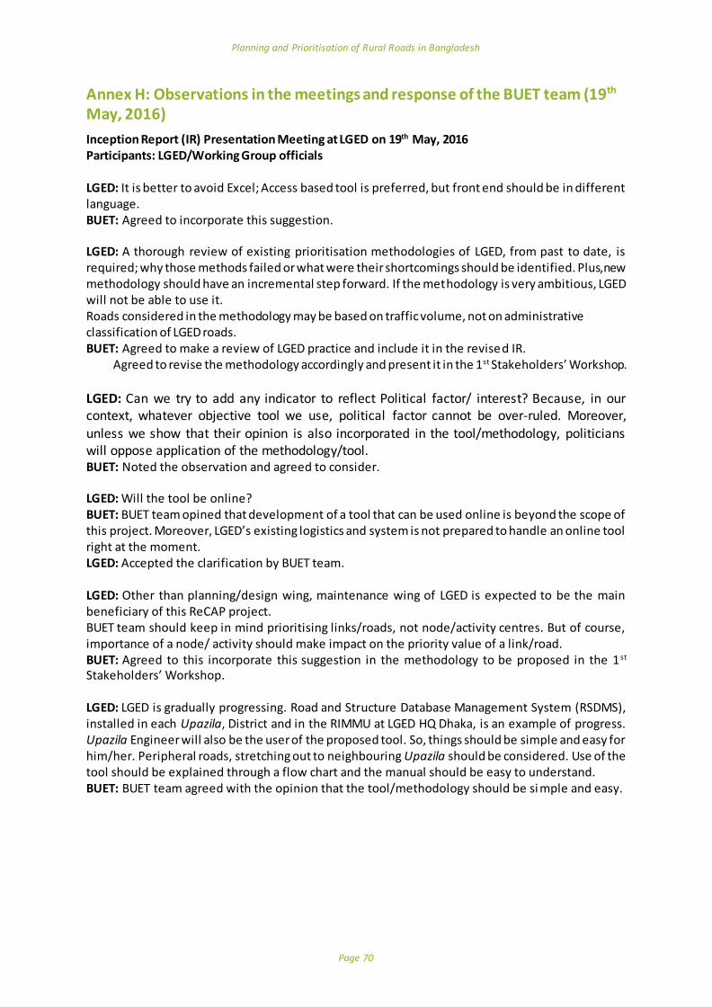
Planning and Prioritisation of Rural Roads in Bangladesh
Page 70
Annex H: Observations in the meetings and response of the BUET team (19th May, 2016)
Inception Report (IR) Presentation Meeting at LGED on 19th May, 2016 Participants: LGED/Working Group officials
LGED: It is better to avoid Excel; Access based tool is preferred, but front end should be in different language. BUET: Agreed to incorporate this suggestion. LGED: A thorough review of existing prioritisation methodologies of LGED, from past to date, is required; why those methods failed or what were their shortcomings should be identified. Plus, new methodology should have an incremental step forward. If the methodology is very ambitious, LGED will not be able to use it. Roads considered in the methodology may be based on traffic volume, not on administrative classification of LGED roads. BUET: Agreed to make a review of LGED practice and include it in the revised IR. Agreed to revise the methodology accordingly and present it in the 1st Stakeholders’ Workshop.
LGED: Can we try to add any indicator to reflect Political factor/ interest? Because, in our context, whatever objective tool we use, political factor cannot be over-ruled. Moreover, unless we show that their opinion is also incorporated in the tool/methodology, politicians will oppose application of the methodology/tool. BUET: Noted the observation and agreed to consider. LGED: Will the tool be online? BUET: BUET team opined that development of a tool that can be used online is beyond the scope of this project. Moreover, LGED’s existing logistics and system is not prepared to handle an online tool right at the moment. LGED: Accepted the clarification by BUET team. LGED: Other than planning/design wing, maintenance wing of LGED is expected to be the main beneficiary of this ReCAP project. BUET team should keep in mind prioritising links/roads, not node/activity centres. But of course, importance of a node/ activity should make impact on the priority value of a link/road. BUET: Agreed to this incorporate this suggestion in the methodology to be proposed in the 1 st Stakeholders’ Workshop. LGED: LGED is gradually progressing. Road and Structure Database Management System (RSDMS), installed in each Upazila, District and in the RIMMU at LGED HQ Dhaka, is an example of progress. Upazila Engineer will also be the user of the proposed tool. So, things should be simple and easy for him/her. Peripheral roads, stretching out to neighbouring Upazila should be considered. Use of the tool should be explained through a flow chart and the manual should be easy to understand. BUET: BUET team agreed with the opinion that the tool/methodology should be si mple and easy.
Planning and Prioritisation of Rural Roads in Bangladesh
Page 71
Annex I: Observations in the meetings and response of the BUET team (14th June, 2016)
Steering Committee Meeting on the Inception Report on 14th June 2016 Participants: LGED and ReCAP officials LGED: International Roughness Index (IRI) should not be considered as a criterion for maintenance; it can be considered as a screening/filtering parameter. BUET: Accepted the suggestion and agreed to present the revised methodology at the Stakeholders’ Workshop. LGED: What will be the sources of data? If any field survey would be conducted or not? If field data were not used, would it serve the purpose of the project? BUET: The tool and methodology will primarily be based on LGED RSDMS. Demographic and other relevant data from Bangladesh Bureau of Statistics (BBS) will also be used. Field survey will only be done when data is not found in any of the sources stated above and finally, to verify some data and output produced by the tool prepared. LGED: If agricultural value chain and special criteria (like connectivity to power plant, tourist spot etc) could be considered. BUET: Agreed to include “special purpose” as a separate entity to reflect special needs of power station, tourist spot, etc. However, did not agree to consider the inclusion of agricultural value chain as such a micro-level analysis is beyond the scope of the project, would require vast amount of field work – not only by the BUET team, but also by the potential LGED users, and diminish the utility of the tool. ReCAP: Noted, positively, that RED software was not going to be used and a new software would be developed by the BUET team. He asked the BUET team to revise the Inception Report incorporating the comments and suggestions made at the meetings together with the response of the team. BUET: BUET team agreed that the response of the BUET team to the comments and suggestions would be compiled and included in the revised Inception Report. ReCAP: Justification for considering each criterion should be clarified. BUET: Agreed to consider the suggestions in the revised methodology to be presented in the 1 st workshop. LGED: Finally, it was stated that terminologies like “New Construction”, “Further Improvement” and “Maintenance” may create confusion and may be contradictory to current practices. After discussion it was suggested that candidate roads would be considered under categories: “Improvement”, “Further Improvement” and “Maintenance”. BUET: Agreed to use the three suggested terms. BUET: Raised the issues concerning new software development for the project. Hence a computer programmer should be added/approved as a key person in the BUET team. Consequently cost and project duration would need revision. ReCAP: Advised the BUET team to communicate the requirement, including a request for revising project budget and schedule.
Planning and Prioritisation of Rural Roads in Bangladesh
Page 72
Annex J: Survey Instrument (Sample AHP Questionnaire)
Planning and prioritisation of rural roads in Bangladesh
Multi-Criteria Analysis Survey Instrument (Sample instrument) Form 1: Prioritisation for improvement of rural roads (low volume unpaved road) Date: _______________ Location ____________________ Surveyor: ________________________ Information on the respondent: Name (Optional) ____________________________________________ Occupation: a. Official of the Ministry_____________________
b. LGED Official _____________________
c. Local Official _____________________
d. Expert _____________________
e. Local leader _____________________
f. Other _____________________
Additional information and comments by the respondent (if any): Pairwise comparison: For each pair of criteria in the table below (there are 15), please think carefully and consider which criterion is more important, A or B. On a 10-point scale, rate the relative importance of the more important criterion compared with the other one. For example, for the first pair, between the two criteria connectivity and population served by the road, which one you consider more important? Should you consider population served is more important than connectivity, provide a rating for this importance. If you consider population served is considerably more important than connectivity, you may rate this importance as 5. Put 5 in the third cell.

Planning and Prioritisation of Rural Roads in Bangladesh
Page 73
Explanatory notes for each criterion are provided below the table.
Criterion A
Criterion B
On a 10-point scale, rate if criterion A is more important than B ( 1 means slightly more important; 3 means more important; 5 means considerably more important; 7 means highly more important; 9 means extremely more important; other points are in-between these importance levels)
On a 10-point scale, rate if criterion B is more important than A ( 1 means slightly more important; 3 means more important; 5 means considerably more important; 7 means highly more important; 9 means extremely more important; other points are in-between these importance levels)
A is more important B is more important
Connectivity Population served
Connectivity Facilities served
Connectivity Growth centre/Market served
Connectivity Existence of gap
Connectivity Duration of availability
Population served Facilities served
Population served Growth centre/Market served
Population served Existence of gap
Population served Duration of availability
Facilities served Growth centre/Market served
Facilities served Existence of gap
Facilities served Duration of availability
Growth centre/Market served Existence of gap
Growth centre/Market served Duration of availability
Existence of gap Duration of availability
Explanatory notes:
Connectivity: Linkage with national and regional highways or a zila road; linkage with Upazila centre
or a Growth centre; linkage with Union centre or a rural market centre; linkage with an Upazila or
Union road; linkage with special facilities such as an important industry, supply chain point, cyclone shelter etc.
Population served: Estimated population served/km of the road
Facilities served: Number of facilities which include, educational institutions (by type), health facilities, government offices and other public facilities, industries
Growth Centre/Market served: Hats and Bazars (GCs are already designated)
Existence of gap: Physical discontinuity along road alignment
Duration of availability: No. of days a road is available for use, ie, does not remain submerged.
9 8 7 6 5 4 3 2 1 0 1 2 3 4 5 6 7 8 9

Planning and Prioritisation of Rural Roads in Bangladesh
Page 74
Scalable logos for use for ReCAP, AfCAP and AcCAP reports
Planning and Prioritisation of Rural Roads in Bangladesh
Page 75