Embed Size (px)
Citation preview
PLANNING APPLICATION B/19/0243
Installation of a customised navigation Buoy as asculptural artwork
Coach Station Roundabout, St Georges Road,Boston
Applicant:Luke Skerritt, Boston Borough Council
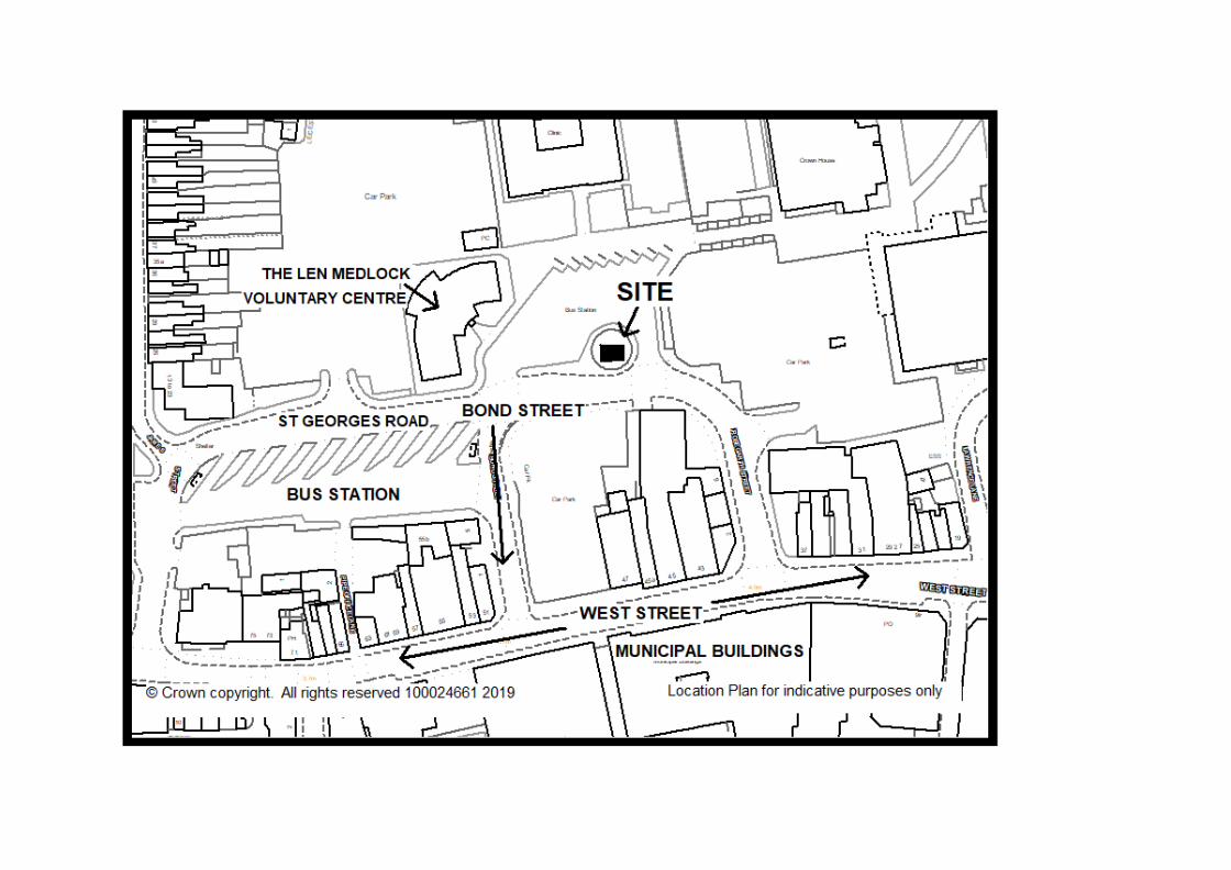
BOSTON BOROUGH COUNCIL
Planning Committee – 23 July 2019
Reference No: B/19/0243
Expiry Date: 07-August-2019Extension of Time: n/a
Application Type: Full Planning Permission(s)Proposal: Installation of a customised navigation Buoy as a sculptural artwork
Site: Coach Station Roundabout, St Georges Road, Boston
Applicant: Luke Skerritt, Boston Borough CouncilAgent: v/a
Ward: Station Parish: n/a
Case Officer: Myles Joyce Third Party Reps:
Link to Application: B/19/0243
Recommendation: GRANT
1.0 Reason for Report
1.1 This application is proposed by Boston Borough Council as part of a wider publicrealm improvement project, as such the Growth Manager considers that it is ofsufficient public interest that it should be presented to the Planning Committee.
2.0 Application and site description
2.1 It is proposed to erect a buoy 4.2 metres high and 3 metres in diameter. Withartworks the final dimension are expected to be 5.0 metres high by 5.0 metres indiameter.
2.2 The artwork will have an increased width dimension due to its design and beingplaced at an angle.
2.3 It is a concept built on the uniqueness of each buoy and flotsam and jetsamassociated with their original maritime environments. The sculptural structuresurrounding the buoy will incorporate laser cut steel and potentially some reusedcabling associated with the buoys. The buoy subject of this application is part of awider project of 5 buoys in various locations across the town to enhance the publicrealm.
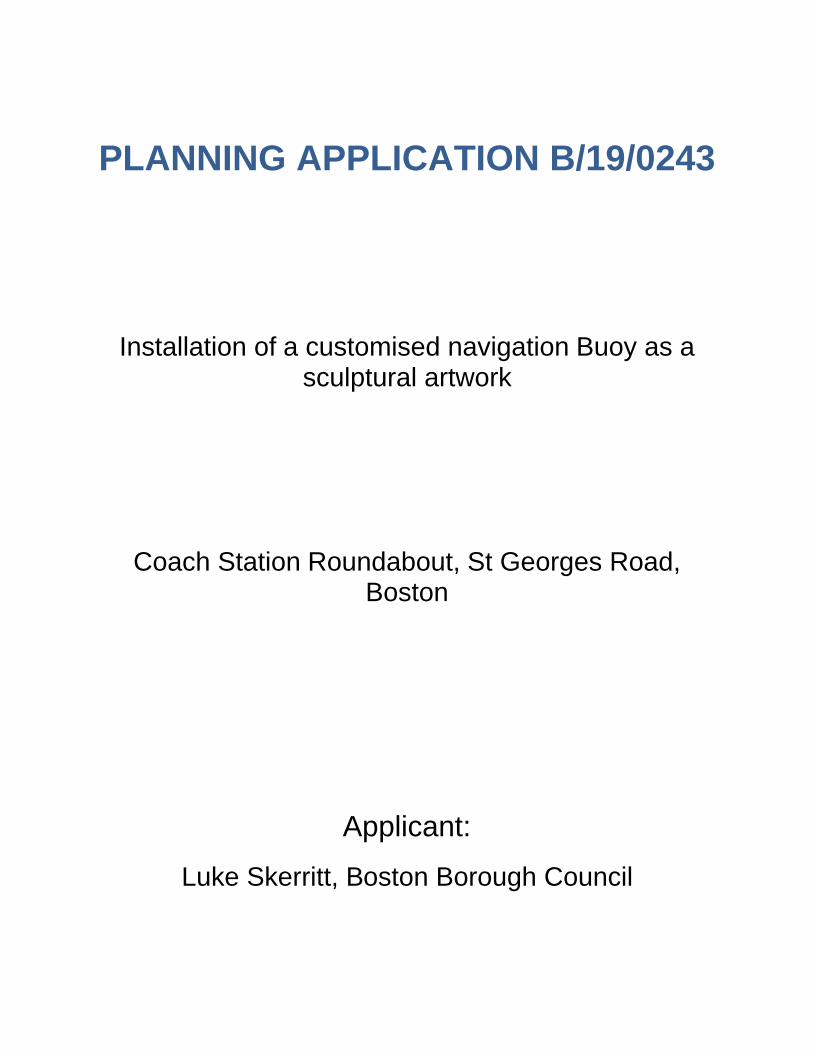
2.4 It will be located on the roundabout adjacent to the Coach Station. Due to thelocation of this buoy it is anticipated that a reinforced concrete raft will be necessarybut this will be discrete and not change the overall look of the installation.
2.5 The site lies within Boston Conservation Area.
3.0 Relevant History
3.1 The application is one of five submitted for the installation of a customisednavigation Buoys as a sculptural artworks. The other applications are also beforeyou for determination as follows:
§ B/19/0242 Installation of a customised navigation Buoy as a sculpturalartwork Promontory Opposite Black Sluice, Boston§ B/19/0244 Installation of a customised navigation Buoy as a sculpturalartwork Land adjacent to Haven Bridge, Buoy Yard Car Park, Boston§ B/19/0245 Installation of a customised navigation Buoy as a sculpturalartwork Land adjacent to Haven Bridge, South Square, Boston§ B/19/0246 Installation of a customised navigation Buoy as a sculpturalartwork, Adjacent to Art Deco Garden, Central Park, Boston
4.0 Relevant Policy
4.1 The Development Plan now consists of the South East Lincolnshire Local Plan(2011-2036) (i.e. SELLP) which was adopted by the Boston Borough Council andthe South Holland District Council on the 8th March 2019.
4.2 Policy 2: Development Management requires development to be inter aliasustainable development of a size, scale, layout and density which accords with thesurrounding area, pays attention to quality of design, maximises the use of
sustainable materials and resources and impacts and enhances areas of naturalhabitats or historical buildings and heritage assets.
4.3 Policy 3: Design of New Development All development will create distinctive placesthrough the use of high quality and inclusive design and layout and, whereappropriate, make innovative use of local traditional styles and materials. Designwhich is inappropriate to the local area, or which fails to maximise opportunities forimproving the character and quality of an area, will not be acceptable.
4.4 Development proposals will demonstrate how the following issues, where they arerelevant to the proposal, will be secured by creating a sense of place bycomplementing and enhancing designated and non-designated heritage assets;historic street patterns; respecting the density, scale, visual closure, landmarks,views, massing of neighbouring buildings and the surrounding area and theappropriate use or reuse of historic buildings.
4.5 Policy 4 : Approach to Flood Risk states that development proposed within an areaat risk of flooding (Flood Zones 2 and 3 of the Environment Agency’s flood map orat risk during a breach or overtopping scenario as shown on the flood hazard anddepths maps in the Strategic Flood Risk Assessment) will be permitted, where itcan be demonstrated that there are no other sites available at a lower risk offlooding and demonstrates that the proposal will not increase risk elsewhere andensures suitable access is safeguarded for the maintenance of water resources,drainage and flood risk management infrastructure.
4.6 Policy 9: Promoting a Stronger Visitor Economy supports proposals for tourism andvisitor development which utilise and enrich the natural and built environment andexisting attractions of South East Lincolnshire to the benefit of the local economy,visitors and local communities will be supported within the boundaries ofsettlements identified in Policy 1 as well as other ancillary development slinked tothe above uses. Outside these settlements, small-scale development to support thevisitor economy, including farm diversification, equine development and fishinglakes, will be supported provided that proposals do not conflict with neighbouringland uses; are in keeping with the character of the locality; and demonstrate afunctional link with an existing rural attraction or farm enterprise.
4.7 Policy 25: Supporting the Vitality and Viability of Boston and Spalding Town CentresOpportunities to support and extend the offer of the town centres as destinationsthrough enhancing existing sites and ensuring changes to premises have regard tothe significance of heritage assets and the special interests of the ConservationAreas and their settings and enhancing the public realm through improvements topublic spaces, accessibility and signage and providing interpretation andpromotional information.
4.8 Policy 29: The Historic Environment seeks to preserve or enhance the historicenvironment will be conserved and, where appropriate, enhanced. Developmentproposals will conserve and enhance the character and appearance of designatedand non-designated heritage assets. Proposals that affect the setting of a ListedBuilding will be supported where they preserve or better reveal the significance ofthe Listed Building.
4.9 Proposals within, affecting the setting of, or affecting views into or out of, aConservation Area should preserve (and enhance or reinforce, as appropriate)features that contribute positively to the area’s character, appearance and setting.
4.10 Policy 32: Community, Health and Well-being states that development shallcontribute to: the creation of socially-cohesive and inclusive communities; reducinghealth inequalities; and improving the community’s health and well-beingencouraging inter alia community use.
4.11 National Planning Policy Framework (2019)
The NPPF is a material consideration in decision-taking. Relevant sections of theNPPF that are relevant to this application are:
§ Section 2 : Achieving sustainable development§ Section 8: Promoting healthy and safe communities§ Section 12: Achieving well designed places§ Section 14: Meeting climate change, flooding and coastal change§ Section 16: Conserving and Enhancing the Historic Environment
4.12 Town & Country Planning (Listed Buildings and Conservation Areas) Act 1990
S72 of the 'Act' sets out the Local Planning Authority has a general duty to givespecial attention to the desirability of preserving or enhancing the character orappearance of Conservation areas.
5.0 Representations
5.1 No letters of representation have been received
6.0 Consultations
6.1 County LLFA have not responded
6.2 Black Sluice Internal Drainage Board no objections
6.3 Building Control have not responded
7.0 Planning Issues and Discussions
7.1 The key planning issues in the determination of this application are:
§ The principle of development having regard to development plan policies.§ Impact on residential amenity.§ Impact on the character and appearance of the Conservation Area.§ Supporting a visitor economy.§ Flood risk and drainage.
The principle of development having regard to development plan policies
7.2 The application site lies within the Boston Conservation Area and the town centreboundary. Developments should support and extend the office of the town centreas a visitor destination and have regard to heritage assets and special interests ofconservation areas. As a piece of ornamental public art it is considered that thedevelopment provides a statement of the town and its heritage and a visitorattraction and is considered acceptable in principle.
7.3 The proposal would be an attractive piece of public art which would enhance thevisitor experience to Boston in accordance with Policies 9 and 32 of the SELLP andpart 8 of the revised NPPF.
Impact on residential amenity
7.4 The site lies within the Boston Bus Station and is a significant distance from nearbyresidences. As such any impact on any residential amenity is not considered to bematerial.
Impact on the character and appearance of the Conservation Area
7.5 The design concept is indicative only of the final work and not a full rendition of thefinal design which will evolve throughout, and in response to the delivery phases ofthe project. The concept will not change substantively.
7.6 Due to the location of this buoy it is anticipated that a reinforced concrete raft willbe necessary but should this be required it would be discrete and not change theoverall look of the installation.
7.7 Whilst the ornamental artwork is indicative, the essential dimensions of the buoyand its means of being affixed to are the key components of the scheme with anyfinal artistic work being ancillary to the proposed development.
7.8 It is considered that the proposal as a piece of public art would enhance thecharacter and appearance of the Boston Conservation Area and as such isconsidered to be in accordance with Policies 2 and 29 (The Historic Environment)of the SELLP and Parts 12 and 16 of the Revised NPPF, as well as meeting therequirements set out in S72 of the Town & Country Planning (Listed Buildings andConservation Areas) Act 1990 .
Flood risk and drainage
7.9 The site is within Flood Zone 3. Policy 4: Approach to Flood Risk states thatdevelopment proposed within an area at risk of flooding (Flood Zones 2 and 3 ofthe Environment Agency’s flood map will be permitted, where it can bedemonstrated that there are no other sites available at a lower risk of flooding anddemonstrates that the proposal will not increase risk elsewhere and ensuressuitable access is safeguarded for the maintenance of water resources, drainageand flood risk management infrastructure.
7.10 The proposal is for limited changes to the existing surface with minor works toanchor the buoys in place. It is considered that the buoys would have a neutralimpact on the flood risk to the site or surrounding area and as such is consideredto accord with Policy 4 and Part 14 of the NPPF.
8.0 Summary and Conclusion
8.1 The principle of development is accepted as a work of public art and a visitorattraction and it is considered that it would enhance the visual appearance of thesurrounding area and provide an attraction which would have potential economicbenefit through local spend to the immediate surrounding area. The proposal alsoforms part of a wider project to enhance the public realm. It is therefore consideredthat the proposal will provide some social and economic benefits.
8.2 The impact on flood risk is considered to be neutral and therefore there is nonegative environmental impact. Therefore, the development demonstratessustainable development and as such accords with the core principle of the NPPF.
8.3 The impact on the character and appearance of the Conservation Area and theTown Centre is considered to be beneficial, providing a point of interest, andenhancing a visitor experience thus a further modest benefit.
8.4 The benefits of the proposed development are set out above and the proposalaccords with Policies 2, 3, 4, 9, 25 and 32 of the SELLP and Parts 2,8,12, 14 and16 of the NPPF.
9.0 Recommendation: GRANT
9.1 It is recommended that this application is approved subject to the conditions set outbelow.
1. The development hereby permitted shall be begun before the expiration of threeyears from the date of this permission.
Reason: Required to be imposed pursuant to Section 51 of the Planning andCompulsory Purchase Act 2004.
2. The development hereby approved shall be carried out in accordance with theApproved specifications set out in the “Planning Design Statement Boston QuaysScheme”
Reason: To ensure the development is undertaken in accordance with theapproved details and to accord with Policies 2 and 3 of the South East LincolnshireLocal Plan (2011-2036).
Informative
In determining this application the authority has taken account of the guidance inparagraph 38 of the National Planning Policy Framework 2019 in order to seek to securesustainable development that improves the economic, social and environmental conditionsof the Borough.
Mike GildersleevesGrowth Manager