Embed Size (px)
Citation preview
Zelinka Priamo Ltd. i
83 March 2020
Planning Justification Report
834 Lakeshore Road, Sarnia
Zelinka Priamo Ltd. ii
ary 2020
TABLE OF CONTENTS
Page No
1.0 INTRODUCTION AND BACKGROUND ................................................................ 3
2.0 SUBJECT LANDS AND CONTEXT ...................................................................... 8
3.0 CONCEPT PLAN ................................................................................................. 10
4.0 PROPOSED OFFICIAL PLAN AND ZONING BY-LAW AMENDMENTS ........... 11
5.0 PLANNING DOCUMENT REVIEW AND POLICY ANALYSIS ........................... 13
5.1 PROVINCIAL POLICY STATEMENT 2014 (PPS) .............................................. 13
5.2 THE LAMBTON COUNTY OFFICIAL PLAN ....................................................... 18
5.3 THE CITY OF SARNIA OFFICIAL PLAN ............................................................ 29
5.4 THE CITY OF SARNIA ZONING BY-LAW NO. 85 of 2002 ................................ 54
6.0 CONCLUSION ..................................................................................................... 55
APPENDIX A SIGNIFCIANT FEATURES & PROPOSED DEVELOPEMNT
TREE INVENTORY AND PRESERVATION PLAN
APPENDIX B SURVEY
APPENDIX C CONCEPT PLAN
APPENDIX D ZONING
Zelinka Priamo Ltd. 3
1.0 INTRODUCTION AND BACKGROUND
Zelinka Priamo Ltd. has been retained by Paul Wicks to submit an application for amendments to
the City of Sarnia Official Plan and Zoning By-law to facilitate land division for a residential
development on lands located on Lakeshore Road in the City of Sarnia. The application includes
measures to protect woodlands. No amendment is required to the Lambton County Official Plan.
A similar application (OPA 12) was refused by Council in November 2018. The current application
has been modified to address natural heritage issues stated as the primary reason for refusal of
OPA 12.
The original application was accompanied by an Environmental Impact Study (henceforth EIS)
prepared by Natural Resources Solutions Inc. (henceforth NRSI), a Shoreline Hazard
Assessment by Shoreplan Engineering Limited and a Planning Justification Report by B.M. Ross
& Associates Limited.
Planning staff concluded:
"The proposal to develop in the significant woodland identified in the City of Sarnia Official
Plan must demonstrate that there will be no negative impact to the feature. Based on the
comments of the St. Clair Region Conservation Authority:
• The Environmental Impact Study (EIS) has failed to demonstrate “no negative impact” to
the significant woodland feature (FOD1 vegetation community) and its ecological
functions, and,
• The EIS has not evaluated the adjacent lands (CUS1 vegetation community), being lands
within 120m of the boundary of the significant woodland), and therefore has failed to
demonstrate “no negative impact” on adjacent lands areas and ecological functions.
For the reasons outlined in this report, staff is of the opinion that development in the
significant woodland is not consistent with the PPS and not in conformity with the County
and City OPs. Staff recommends that the application be refused.”
Notice of refusal stated:
“The proposed official plan amendment was refused for the reasons that the application
has not demonstrated “no negative impact” on the significant woodland feature and its
ecological functions and adjacent lands, and the application is not consistent with the
Provincial Policy Statement, County of Lambton Official Plan, and Sarnia Official Plan. In
making its decision, Council considered the written submissions included in the staff
report and the oral submissions made at the public meeting.”
The City of Sarnia Pre-Application Report dated October 22, 2019 for the current application
advised, among other matters, that a step to advance the proposal was to “coordinate a review
of the EIS with the SCRCA”.
Zelinka Priamo Ltd. 4
Summary of EIS
The EIS prepared by NRIS in support of this application conducted field surveys including
vegetation surveys, tree inventory, breeding birds, reptile emergence, bat cavity tree assessment
and other wildlife. The EIS identified natural environment development constraints including
significant woodland, species at risk habitat (Bats), significant wildlife habitat (Birds) and
regionally significant habitat and species (Plants).
According to NRIS, impacts to adjacent woodland features to be retained can be addressed
through various mitigation measures such as tree protection fencing, rear yard native species
planting and land owner information/educational materials on the importance of protecting
vegetative and wildlife habitat. Recommended tools to protect natural features and ecological
functions include site specific protective zoning, restoration (e.g. removal of non-native
vegetation, replanting with native species prior to sale of lots) and post development monitoring,
and stewardship information/education material. Tree replacement (2 for 1) in accordance with
County and local policies is recognized as required in the EIS. Monitoring pre-construction (e.g.
sediment and erosion control, tree protection), during construction (e.g. best management
practices such as storage of machinery and material fill in designated areas) and post-
construction (e.g. inspection of transplants on site and inspection of off property compensation
plantings) is also recommended.
NRIS applied Ecological Land Classification, and found the lot is divided into Mineral Cultural
Savannah Ecosite (CUS1) and Dry-Fresh Oak Deciduous Forest Ecosite (FOD1). FOD 1 is
significant woodland. Appendix A to this Report is Map 3, Significant Features and Proposed
Development from the NRSI EIS which identifies the: FOD1 and CUSI Ecosites, Subject
Property, Bat Cavity Tree, Grading Limits, Building Envelope, Lot Line, and the Surveyed Dripline.
The Tree Inventory and Preservation Plan from the EIS is also in Appendix A. The Proposed
Development/Concept Plan is shown on Map 3.
The NRIS EIS analysis using Provincial criteria outlined in the Natural Heritage Reference Manual
(OMNR 2010) found that FOD1 parts of the woodland on the subject lands and on adjacent lands
is significant under the criteria for Ecological Functions and Uncommon Characteristics. The
following is a brief summary of our understanding of the analysis.
The Ecological Functions criteria include: the woodland having a minimum area threshold of 0.5-
2.0 ha, and being in proximity to other natural features, i.e. the lakeshore, and another woodland
located approximately 200 m (656 ft.) east of the subject lands which is identified as a ‘Type B’
Natural Area in the Sarnia Official Plan. The Lake Huron Lakeshore is a linkage corridor, which
facilitates wildlife (Birds) movement as part of linkage for migratory birds that travel along the Lake
Huron shoreline.
Zelinka Priamo Ltd. 5
Uncommon Characteristics are the woodland appearing to represent former oak woodland or oak
savannah. The woodland provides habitat for plant species that are regionally significant,
notwithstanding significant infill in the woodland from native and non-native woody species. It is
our understanding that historically this type of woodland is reliant on fire to allow for continued
growth of oak and maintaining an open canopy for understory plants. An alternative to fire
disturbance is required at this location. Restoration efforts will likely not create a self sustaining
woodlot.
The EIS estimated that 2300 m2 (0.23 ha/0.57 ac.) of significant woodland will require removal.
(Based on NRSI mapping approximately 7100 m2 (0.71 ha/1.75 ac.) of significant woodland is
located on the subject lands and there is approximately 9,400 m2 (0.94 ha/2.32 ac.) contiguous
significant woodland for a total of 16,500 m2 (1.65 ha/4.1 ac.) of significant woodland on the
subject lands and adjacent lands. Approximately 0.48 ha of significant woodland would remain
on the subject lands).
Adjacent lands, that are not significant woodland, located at the north end of the subject lands
have an area of 5900 m2 (0.59 ha/1.46 ac.).
St. Clair Region Conservation Authority Review of EIS
The St. Clair Region Conservation Authority (henceforth SCRCA) reviewed the amended EIS,
dated November 2019, prepared by NRSI. The EIS was prepared in accordance with policy 8.8.3
Environmental Impact Studies in the County Official Plan and policies 4.3.3.4 “Type B Protection”
and 4.3.3.9 “Environmental Impact Studies” in the City of Sarnia Official Plan.
In correspondence dated December 23, 2019 the SCRCA reviewed the applicable City of Sarnia
Official Plan Natural Heritage policies that apply to the subject lands and the findings of the EIS
Phase 1 and Phase 2. According to the SCRCA the EIS:
• Found the site has significant woodland based on county, municipal and provincial
guidelines.
• Applied Ecological Land Classification, and found the lot is divided into Mineral
Cultural Savannah Ecosite (CUSI) and Dry-Fresh Oak Deciduous Forest Ecosite
(FOD1).
• CUS1 is highly modified through landscaping and mowing and no longer contains
understory or groundcover vegetation and is not significant woodland. NRSI
recommends tree retention in CUS1 as this is part of the Huron Shores Flyway in
the Sarnia Official Plan and Primary Corridor in the Lambton County Official Plan.
• FOD1, like CUSI shows evidence of disturbance and invasive species, however
characterized as an ecologically natural, functioning woodland community. The
EIS noted debris/refuse dumping, the presence of non-native and invasive species
and other edge effects in the FOD1 vegetative community.
• Based on NRSI mapping, found that the FOD1 vegetative community including
adjacent lands is 1.65 ha and 0.71 ha is within the subject property (See Appendix
A, Map 3).
Zelinka Priamo Ltd. 6
• Conducted field surveys in accordance with accepted practice to refine woodland
significance and ecological functions based on criteria outlined in the Natural
Heritage Reference Manual (Ministry of Natural Resources, 2010). Field surveys
included a tree inventory, bat cavity tree assessments, breeding bird surveys and
reptile emergence surveys and found the following:
- Vegetation Survey: No Federally or Provincially rare vegetative species. Four
species rare or uncommon in Lambton County. NRSI recommended relocation
or seed collection and dispersion in areas to be retained in natural cover.
- Tree Inventory: Complete inventory conducted within the significant woodland,
including trees which may provide wildlife habitat particularly for bats. Trees
to be retained and removed were identified. (See Appendix A Tree Inventory
and Preservation Plan).
- Wildlife: Most species observed are birds which likely use the property as a
stop-over site during migration within the Huron Shores Flyway. Majority of the
species are common on human influenced landscapes and the species will
continue to use the habitat, post development.
- Significant Wildlife Habitat: There is no Significant Wildlife Habitat on the
subject property.
- Threatened and Endangered Species: No confirmed habitat for wildlife Species
at Risk (SAR) was documented. Potential habitat, seven cavity trees which
may provide roosting habitat for SAR bat species were identified (See
Appendix A Map 3). Removal of bat cavity trees will not contravene the
Endangered Species Act provided mitigation measures including timing
windows to avoid bat roosting and bat boxes to compensate for lost roosting
habitat. Further discussion with Ministry of Environment, Conservation and
Parks required to confirm mitigation measures when detailed plans available
Based on the vegetation and wildlife surveys by NRSI with reference to the Natural Heritage
Reference Manual criteria for woodland significance the key ecological functions for the woodland
are: habitat for vegetative species which are regionally significant; stop over habitat for migrating
birds; and potential habitat for bat species at risk. According to the SCRCA, based on the NRSI
findings the property is significant woodland and therefore the Type B Natural Area policies in the
Natural Heritage System policies in the City of Sarnia Official Plan apply. The SCRCA finds:
- Negative impact on the natural heritage features and the ecological functions
for which the area is identified noting that NRSI proposed measures to offset
impacts.
- Four (4) lots are partially or completely within natural area notwithstanding that
there is alternative development area outside of the natural area on the subject
lands.
- The property contains hazardous areas within the shoreline hazard of Lake
Huron; however, the proposed building envelopes appear to be directed
outside of the shoreline hazard.
- The property is not considered a vulnerable area for groundwater.
- The proposed development is not consistent with Official Plan policies.
Zelinka Priamo Ltd. 7
- Building envelopes should be directed outside of the significant woodland.
- If the City supports lot creation within the natural area and development within
the Type B feature, it be conditional on natural environment enhancements
such as reforestation and conservation agreement.
- The proposed development would remove 0.23 ha (2300 m2, 24,756 square
feet) of significant woodland.
- The remaining 1.42 ha (14,200 m2/152,847.5 square feet) meets the
significance criteria of greater than 0.5 ha (5,000 m2/53,819.6 square feet).
Regarding Phase 2 of the Environmental Impact Study, the SCRCA reviewed the City of Sarnia
Official Plan Reforestation Requirements found in Policy 5.12.3. Replacement requirement is
0.46 ha (4,600 m2,49,514 square feet) with preference given to reforestation on the same site;
adjacent to designated natural areas; and within natural hazards. Long term management of
replacement trees are to comply with the County of Lambton Woodlands Conservation By-law.
Regarding NRSI recommendation that protective municipal zoning be placed on the retained
woodland features to restrict activities of future landowners in the woodland, SCRCA expressed
strong enforcement.
If such site specific zoning is not available as determined by the City then compensation planting
for the entire area of the subject property will occur with no restoration efforts for the woodland on
the subject lands. Replacement at a 2:1 ratio for 0.71 ha of significant woodland requires 1.42 ha
of compensation planting, with no on-site restoration. The SCRA favours off site compensation
for the entire portion of significant woodland property on the property and no site-specific zoning.
The following sections of this report review the existing land use on the subject lands and
surrounding area, the Provincial Policy Statement 2014, the Lambton County Official Plan 2014,
the City of Sarnia Official Plan 2016, the City of Sarnia Zoning By-law No. 85-2002, The Lambton
County Tree Conservation By-law, The Planning Justification Report prepared by B. M. Ross &
Associates Limited, the Environmental Impact Study as amended January, 2020 and its
predecessor dated November 2017 by Natural Resources Solutions Inc. (NRSI), the Shoreline
Hazards Assessment, November 2017, prepared by Shoreplan Engineering Limited, the
Community Development Services and Standards Department report dated November 5, 2018,
Correspondence from the St. Clair Region Conservation Authority dated December 23, 2019
September 14, 2018 and January 31, 2018 and the City of Sarnia Pre-Application Report dated
October 22, 2019. Zelinka Priamo Ltd. staff visited the site and surrounding area on January 4.
2019. Relevant policies and regulations are italicized, followed by comments where required.
The purpose of the review is to demonstrate that the proposed Official Plan and Zoning By-law
Amendments are consistent with the general intent of the Sarnia Official Plan; that the amendment
conforms to the County’s Official Plan and the Provincial Policy Statement; and that the
amendment is appropriate and can be justified in light of accepted planning principles as required
by policy 7.3 Amendments to the Official Plan. Residents in the area were advised at open houses
conducted on behalf of the applicant in connection with the previous application. The public will
Zelinka Priamo Ltd. 8
have an opportunity for full participation at the statutory public meeting required by the Planning
Act.
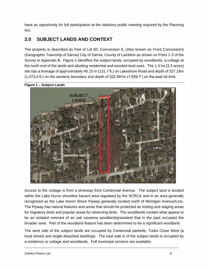
2.0 SUBJECT LANDS AND CONTEXT
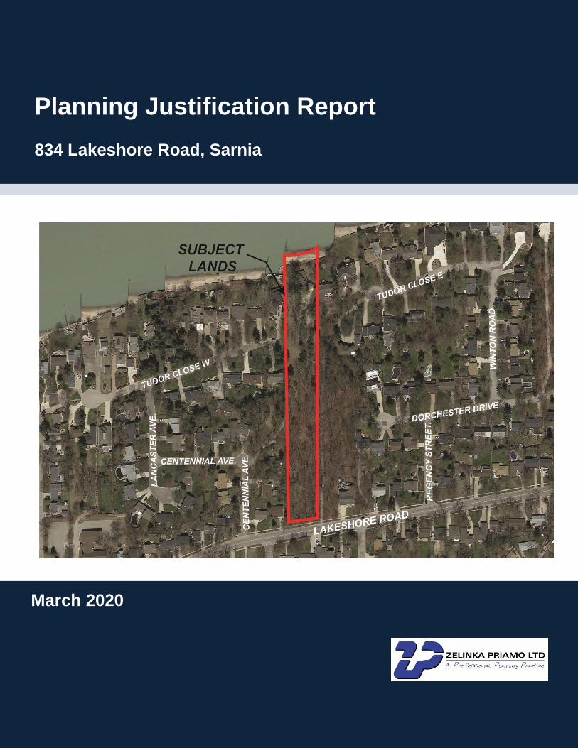
The property is described as Part of Lot 60, Concession 9, (Also known as Front Concession)
(Geographic Township of Sarnia) City of Sarnia, County of Lambton as shown on Parts 1-3 of the
Survey in Appendix B. Figure 1 identifies the subject lands, occupied by woodlands, a cottage at
the north end of the lands and abutting residential and wooded land uses. The 1.3 ha (3.3 acres)
site has a frontage of approximately 40.15 m (131.7 ft.) on Lakeshore Road and depth of 327.18m
(1,073.4 ft.) on the westerly boundary and depth of 322.991m (1,059.7’) on the east lot limit.
Figure 1 – Subject Lands
Access to the cottage is from a driveway from Centennial Avenue. The subject land is located
within the Lake Huron shoreline hazard area regulated by the SCRCA and in an area generally
recognized as the Lake Huron Shore Flyway generally located north of Michigan Avenue/Line.
The Flyway has natural features and areas that should be protected as resting and staging areas
for migratory birds and popular areas for observing birds. The woodlands contain what appear to
be an isolated remnant of an oak savanna woodland/grassland that in the past occupied the
broader area. Part of the woodland feature has been determined to be a significant woodland.
The west side of the subject lands are occupied by Centennial parkette, Tudor Close West (a
local street) and single detached dwellings. The east side is of the subject lands is occupied by
a residence or cottage and woodlands. Full municipal services are available.
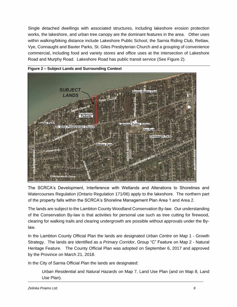
Zelinka Priamo Ltd. 9
Single detached dwellings with associated structures, including lakeshore erosion protection
works, the lakeshore, and urban tree canopy are the dominant features in the area. Other uses
within walking/biking distance include Lakeshore Public School, the Sarnia Riding Club, Retlaw,
Vye, Connaught and Baxter Parks, St. Giles Presbyterian Church and a grouping of convenience
commercial, including food and variety stores and office uses at the intersection of Lakeshore
Road and Murphy Road. Lakeshore Road has public transit service (See Figure 2).
Figure 2 – Subject Lands and Surrounding Context
The SCRCA’s Development, Interference with Wetlands and Alterations to Shorelines and
Watercourses Regulation (Ontario Regulation 171/06) apply to the lakeshore. The northern part
of the property falls within the SCRCA’s Shoreline Management Plan Area 1 and Area 2.
The lands are subject to the Lambton County Woodland Conservation By-law. Our understanding
of the Conservation By-law is that activities for personal use such as tree cutting for firewood,
clearing for walking trails and clearing undergrowth are possible without approvals under the By-
law.
In the Lambton County Official Plan the lands are designated Urban Centre on Map 1 - Growth
Strategy. The lands are identified as a Primary Corridor, Group “C” Feature on Map 2 - Natural
Heritage Feature. The County Official Plan was adopted on September 6, 2017 and approved
by the Province on March 21, 2018.
In the City of Sarnia Official Plan the lands are designated:
Urban Residential and Natural Hazards on Map 7, Land Use Plan (and on Map 8, Land
Use Plan).

Zelinka Priamo Ltd. 10
and are identified as
An element in the Natural Heritage System, and a Stable Residential Area on Map 1, City
Structure Plan;
In the Built-up Area on Map 2, Settlement Boundaries;
In a Highly Vulnerable Aquifer, and Significant Groundwater Recharge Area on Map 3,
Water Resources;
On a 20m Arterial County Road (applied on Lakeshore Road) on Map 4, Transportation &
Road Widening Plan;
Natural Areas ‘Type B’ on Map 5, Natural Heritage; and
Great Lakes System Shoreline Management Area, on Map 6, Natural Hazards.
The subject lands are zoned Urban Residential 1 (UR1) with a Shoreline Management Area 1 &
2 overlay and a Flood Plain overlay on Schedule ‘A’ of Zoning By-law 85 of 2002, Zoning Map
Part 3. Shoreline Management Area 1 & 2 are subject to regulations in Section 3.40(20) in the
Zoning By-law and the Floodplain is subject to Section 3.27 Natural Hazard Regulation.
3.0 CONCEPT PLAN
The concept plan in Appendix B, prepared by Zelinka Priamo Ltd., informed the EIS prepared by
NRIS. The concept plan is overlain on Map 3 from the EIS (see Appendix A).
Six (6) lots are proposed with an extension to Tudor Close West. The proposed concept requires
the removal of approximately 2256.66 m2 (0.23 ha/0.57 ac.) of significant woodland comprised of
approximately: 1300.56 m2 (0.13 ha/0.32 ac.) from the proposed lots fronting on Lakeshore Road;
122.2 m2 (0.012 ha/0.03 ac.) from the road widening on Lakeshore Road; and approximately
833.9 m2 (0.084 ha/0.21 ac.) from the proposed lots fronting on the south side of the proposed
extension of Tudor Close West. The tree removal is required to accommodate the proposed
building envelopes and for grading around the building envelopes proposed to be located in
woodland. Tree removal is proposed in areas that are not significant woodland. The proposal
also requires the removal of the existing cottage and the existing driveway to allow land division
of the property into six (6) lots.
The concept identifies Shoreline Area 1, Shoreline Area 2 and the limit of erosion hazard. Two
(2) lots are proposed with frontage on Lakeshore Road. Two (2) lots are proposed with frontage
on the north side of proposed extension of Tudor Close West and two (2) lots are proposed with
frontage on the south side of the proposed extension of Tudor Close West. The extension of
Tudor Road West ends at the easterly property line of the subject lands. Existing municipal
services are proposed to be extended from Tudor Close West. Municipal services are available
from Lakeshore Road.
Lot building envelopes, and grading area proposed are identified. The area between the rear
grading limits of the proposed lots fronting on Lakeshore Road and the rear grading limits of the
Zelinka Priamo Ltd. 11
lots on the south side of the proposed extension of Tudor Road West are proposed for woodlot
conservation and management in accordance with the recommendations in the EIS.
Proposed habitable building envelopes are outside of the Lake Huron shoreline hazard. A road
widening on Lakeshore Road is required by the County.
Lot statistics are:
4.0 PROPOSED OFFICIAL PLAN AND ZONING BY-LAW AMENDMENTS
According to the City of Sarnia pre-consultation report dated October 22, 2019, an Official Plan
Amendment is required. Policy 4.3.3.10 in the Sarnia Official Plan states that lot creation in
natural areas is discouraged and severances may only be permitted for:
a) The conveyance of land to public bodies or agencies engaged in the protection,
reestablishment and management of the natural environment; and
b) for minor boundary adjustments.
A subdivision application will be forthcoming subsequent to the review of this application. The
subdivision application review process, conducted in accordance with Section 7.2.2 Plans of
Subdivision, Plans of Condominium and Part Lot Control requires compliance with the Official
Plan, the Planning Act, the Provincial Policy Statement among other matters such as agreements
(e.g. tree replacement, conservation, provision of funds, services, and utilities). The proposed
Official Plan Amendment includes the following clause:
“Notwithstanding policy 4.3.3.10 land division may be permitted to allow land division for
residential and natural area uses on lands municipally known as 834 Lakeshore Road.
Residential and natural area uses shall be zoned in the implementing Zoning By-law.”
Section 37 of the Zoning By-law is the Environmental Protection Area 1 Zone (EPA1). EPA1
permits, among other uses, Conservation and Woodlot. Implementation of the proposed Official
Plan Amendment requires an amendment to subsection 37.3 Site and Area Regulation (a
proposed EPA1-x) in the Zoning By-Law. The regulation would permit only Conservation and
Woodlot uses on the lands proposed for woodlot use. Conservation is defined in the Zoning By-
law as:
Zelinka Priamo Ltd. 12
"CONSERVATION" means the use of land and/or water for the purpose of planned
management of natural resources, including wood lot management, and for the
preservation and enhancement of the natural environment.”
Woodlot is not defined in the Zoning By-law. The proposed EPA1-x Zone enables conservation
agreements at subdivision review to provide the opportunity to maintain, protect and enhance the
natural heritage features and ecological function of the significant woodlot. No protection is
provided for the woodland under the current zoning.
The lands are zoned Urban Residential 1 Zone (UR1). The UR1 Zone permits single detached
dwellings among other uses including accessory uses and buildings, place of worship, day care
centres, group homes, lawfully existing dwellings and dwelling conversions, schools. and
women's shelters. Proposed lots 5 and 6 comply with the regulations that apply to single detached
residential use and the hazard and shoreline management special provisions in the Zoning By-
law. Proposed building envelopes are outside erosion and hazard limits. The existing UR1 Zone
with the hazard and shoreline management overlays are proposed for lots 5 and 6.
A Site and Area Regulation (UR1-x) Zone is proposed for lots 1, 2, 3 and 4. The purpose is to
divide the area proposed to be zoned UR1-x Zone with its regulations from the proposed EPA1-
x Zone with its regulations. The proposed zone boundary is the Grading Limits at the rear of the
Building Envelopes of lots 1, 2, 3 and 4 on the concept plan.
Zone Boundary is defined as:
"ZONE BOUNDARY" shall mean a line dividing two or more different Zones as herein
defined.”
Rear lot line is defined as:
"LOT LINE, REAR” means in the case of a lot having 4 or more lot lines, the lot line farthest
from and opposite to the front lot line. If a lot has less than 4 lot lines, there shall be
deemed to be no rear lot line.
The rear lot lines of lots 1, 2, 3 and 4 farthest away from their front yards located at the extension
of Tudor Close West and Lakeshore Road encompass the area proposed to be zoned UR1-x and
EPA1-x Zone. A Site and Area Regulation is required to define the boundary between the
proposed zones.
Rear Yard is defined as:
"YARD, REAR" means a yard extending across the full width of the lot between the rear
lot line of the lot and the foundation of any main building on the lot. If there is no rear lot
line, there shall be deemed to be no rear yard.”
The proposed rear yards of lots 1, 2, 3 and 4 are between the proposed Building Envelopes and
the Grading Limits at the rear of the Building Envelopes. A Site and Area Regulation is required
to define rear yard of the UR1-x Zone.
Zelinka Priamo Ltd. 13
The proposed Site and Area Regulation for UR1-x Zone is:
Yard, rear is the yard extending across the full width of the lot between the rear zone
boundary dividing the EPA-x Zone and the UR1-x Zone and the foundation of any main
building in the UR1-x Zone.
According to the EIS, protective buffers of 10m width are typically applied to the dripline of
Significant Woodlands in order to mitigate adjacent land use impacts, protect tree root zones, and
provide opportunity to enhance woodland edge quality through passive regeneration and/or active
planting where warranted. Based on the proposed development plan, a woodland dripline buffer
from the north end of the FOD1 feature cannot be accommodated. The impacts to adjacent
woodland features to be retained can be addressed through various mitigation measures such as
tree protection fencing or signage, rear yard native species plantings, and landowner
informational/educational materials.
A Site and Area Regulation requiring a 10 m rear yard setback from the EPA-x zone is required
for the UR1-x Zone to implement the recommendation in the EIS.
A Site and Area Regulation providing relief from the provision in Table 1, Section 3.40(2),
Shoreline Regulations that prohibits multi-lot severances and subdivision in Shoreline Areas 1
and 2 is also required to allow the proposed subdivision.
A subdivision application will be submitted following the applications for amendments to the
Official Plan and Zoning By-law. The City may wish to consider a holding provision for the orderly
development of the lands and appropriate agreements to implement the EIS recommendations
regarding the woodland.
5.0 PLANNING DOCUMENT REVIEW AND POLICY ANALYSIS
The following sections provide justification for the need to amend the City of Sarnia Official Plan
and Zoning By-law to facilitate the proposed development and demonstrate consistency with the
applicable policies in the Provincial Policy Statement 2014, and County Official Plan and the
Sarnia Official Plan.
5.1 PROVINCIAL POLICY STATEMENT 2014 (PPS)
The PPS, issued under the authority of Section 3 of the Planning Act, provides policy direction on
matters of provincial interest related to land use planning in order to ensure efficient development
and protection of resources. All planning applications are required to be consistent with these
policies.
Policies in 1.1 Managing and Directing Land Use to Achieve Efficient and Resilient Development
and Land Use Patterns; 1.1.3 Settlement Areas; 1.4 Housing; 1.6.6 Sewage Water and
Stormwater; 2.1 Natural Heritage and 3.1 Natural Hazards apply to the subject lands.
Policy 1.1.1
Zelinka Priamo Ltd. 14
“Healthy, liveable and safe communities are sustained by:
a) promoting efficient development and land use patterns which sustain the financial well-being of the Province and municipalities over the long term;
b) accommodating an appropriate range and mix of residential (including second units, affordable housing and housing for older persons), employment (including industrial and commercial), institutional (including places of worship, cemeteries and long-term care homes), recreation, park and open space, and other uses to meet long-term needs;
c) avoiding development and land use patterns which may cause environmental or public health and safety concerns;
e) promoting cost-effective development patterns and standards to minimize land consumption and servicing costs;
g) ensuring that necessary infrastructure, electricity generation facilities and transmission and distribution systems, and public service facilities are or will be available to meet current and projected needs;
h) promoting development and land use patterns that conserve biodiversity and consider the impacts of a changing climate.
Policy 1.6.6.2
i) Municipal sewage services and municipal water services are the preferred form of servicing
for settlement areas. Intensification and redevelopment within settlement areas on existing
municipal sewage services and municipal water services should be promoted, wherever
feasible.
Policy 3.1.1
a) Development shall generally be directed to areas outside of: a) hazardous lands
adjacent to the shorelines of the Great Lakes - St. Lawrence River System and large inland
lakes which are impacted by flooding hazards, erosion hazards and/or dynamic beach
hazards;”
The proposed development will add to the residential tax base without the need for costly
extension of municipal services. The proposed residential development is consistent with Policies
1.1.1 a) and 1.1.1 e).
The Sarnia Official Plan contemplates residential development commensurate with the level of
hard and soft services provided in this area to meet long term residential needs. The proposed
amendments to allow residential use on the subject lands is consistent with Policy 1.1.1 b).
No habitable buildings are proposed in the flood and hazard areas along the Lake Huron
shoreline. Infrastructure is available to provide full municipal services (sewer, water, storm water),
utilities (gas, hydro, cable) and public service facilities (e.g. recreational, institutional, emergency
services, medical) are in proximity to the subject lands. The proposed amendments are
consistent with Policies 1.1.1 c), 1.1.1 g), 1.6.6.2 and 3.1.1.
The subject lands are located in an area that can be described as a walkable community with
services and facilities within walking distance. The area is also provided bus service along
Zelinka Priamo Ltd. 15
Lakeshore Road. The proposed amendments conserve biodiversity and consider the impacts of
a changing climate as required by Policy 1.1.1 h).
“Section 1.1.3 Policies
1.1.3.1
Settlement areas shall be the focus of growth and development, and their vitality and
regeneration shall be promoted.
1.1.3.2
Land use patterns within settlement areas shall be based on:
a) densities and a mix of land uses which:
1. efficiently use land and resources;
2. are appropriate for, and efficiently use, the infrastructure and public service facilities
which are planned or available, and avoid the need for their unjustified and/or
uneconomical expansion;
3. minimize negative impacts to air quality and climate change, and promote energy
efficiency;
4. support active transportation;
b) a range of uses and opportunities for intensification and redevelopment in accordance
with the criteria in policy 1.1.3.3, where this can be accommodated.
1.1.3.3
Planning authorities shall identify appropriate locations and promote opportunities for
intensification and redevelopment where this can be accommodated taking into account
existing building stock or areas, including brownfield sites, and the availability of suitable
existing or planned infrastructure and public service facilities required to accommodate
projected needs.
Intensification and redevelopment shall be directed in accordance with the policies of Section
2: Wise Use and Management of Resources and Section 3: Protecting Public Health and
Safety.
1.1.3.4
Appropriate development standards should be promoted which facilitate intensification,
redevelopment and compact form, while avoiding or mitigating risks to public health and
safety.
Zelinka Priamo Ltd. 16
1.1.3.6
New development taking place in designated growth areas should occur adjacent to the
existing built-up area and shall have a compact form, mix of uses and densities that allow for
the efficient use of land, infrastructure and public service facilities.”
The subject lands are located in a designated settlement area in the County of Lambton Official
Plan. Settlement areas are stated as the focus of growth in the PPS. The proposed location in
the settlement area is consistent with the PPS policies directing development, intensification,
redevelopment to settlement areas (Policies 1.1.3.1, 1.1.3.6). The area is a fully serviced
settlement area to support the proposed development (Policies 1.1.3.2a)1, 1.1.3.2a)2).
Infrastructure, municipal services, municipal facilities, and services providing the day to day needs
are located within walking distance of the subject lands supporting active transportation (Policies
1.1.3.2a)3) and 1.1.3.2a)4). The PPS encourages and is supportive of the development
standards in the proposed amendment to the Zoning By-law which facilitates intensification and
redevelopment at an appropriate location. The proposed development will have no negative
impacts on the abutting residential uses (Policy 1.1.3.4).
Provided that environmental protection zoning is implemented and mitigation measures
implemented by agreements at the subdivision review stage as stated in the NRSI EIS the woodlot
can be managed to maintain features and functions the proposal is consistent with the direction
consistent with the direction in policy 1.1.3.3 that development be in accordance with the policies
of Section 2: Wise Use and Management of Resources and Section 3: Protecting Public Health
and Safety
The proposed amendment to the Official Plan and Zoning By-law is generally consistent with the
relevant policies in 1.1.3 Settlement Areas.
Policies 2.1.1, 2.1.2, 2.1.5 and 2.1.8
The PPS requires the protection of natural features and areas and encourages diversity and
connectivity of natural heritage systems and maintenance, restoration or, where possible,
improvement recognizing linkages between features. The PPS does not permit development and
site alteration in significant woodlands as stated in Policy 2.1.5 and on lands adjacent to the
significant woodland in Policy 2.1.8 unless it can be demonstrated that there will be no negative
impact on the natural features or their ecological functions.:
“2.1.1 Natural features and areas shall be protected for the long term.
2.1.2 The diversity and connectivity of natural features in an area, and the long-term ecological
function and biodiversity of natural heritage systems, should be maintained, restored or,
where possible, improved, recognizing linkages between and among natural heritage features
and areas, surface water features and ground water features.
Zelinka Priamo Ltd. 17
2.1.5 Development and site alteration shall not be permitted in:
b) significant woodlands
unless it is demonstrated that there will be no negative impacts on the natural features or their
ecological functions.
2.1.8 Development and site alteration shall not be permitted on adjacent lands to the natural
heritage features and areas identified in policies 2.1.4 (significant wetlands and significant
coastal wetlands), 2.1.5 (significant: wetlands, woodlands, valleylands, wildlife habitat, areas
of natural and scientific interest and coastal wetlands), and 2.1.6 (fish habitat) unless the
ecological function of the adjacent lands has been evaluated and it has been demonstrated
that there will be no negative impacts on the natural features or on their ecological functions.”
The PPS direction to demonstrate no negative impact on natural features or their ecological
functions is problematic because the Sarnia Official Plan identifies the subject lands as Type B
Natural Area and as such amendments to the Sarnia Official Plan are required. The most
appropriate mechanism to address matters outside of the Provincial Policy Statement is a site-
specific OPA.
As previously stated, activities for personal use such as tree cutting for firewood, clearing for
walking trails and clearing undergrowth are possible without approvals under the Lambton County
Woodland Conservation By-law or other regulations. Significant disturbance of the woodland is
possible. The proposed OPA and ZBA to facilitate land division provides an
opportunity/mechanism for restoration and enhancement as prescribed in the NRSI EIS and
replacement with at least twice the rate of the approximately 2300 m2 (24,757 sq. ft.) to be
determined at the subdivision approval stage.
The proposed OPA and ZBA are in keeping with the Provincial interest for the protection of
ecological systems, including natural areas features and linkage functions as stated in the
Planning Act. The proposal supports the Provincial interest in conserving natural heritage
features and functions provided the recommendations in the EIS are implemented. According to
the EIS key ecological functions can be maintained.
Key ecological functions for the woodland as stated by the SCRA are: habitat for vegetative
species which are regionally significant; stop over habitat for migrating birds; and potential habitat
for bat species. Recommended mitigation in the EIS, regarding habitat for the vegetative species,
“Any regionally significant vegetation species that may be impacted by the proposed development
will be relocated to appropriate adjacent areas” (pg. 55; NRSI, EIS); regarding stop over habitat
for birds, “tree removal is not expected to negatively impact the migration or breeding habit
functions on the property for the majority of observed bird species which are habitat generalists
and/or are adapted to human-influenced landscapes and urban/residential areas are habitat
generalists” (pg. 42 NRSI, EIS); and for potential bat habitat, Although the study area woodland
Zelinka Priamo Ltd. 18
is not considered to represent significant habitat for bat SAR use of the seven identified cavity
trees as roosting habitat cannot be ruled out…it is recommended that removal of these trees be
timed to occur outside of bat active season…Future consultation with MECP staff will be held to
determine what details of required mitigation measures, including the placement of bat boxes to
replace roosting habitat where required.” (pg. 42 NRSI, EIS).
Site statistics show that the significant woodland area proposed not to be disturbed on the subject
lands is approximately 4800 m2 (0.48 ha, 1.24 ac.). The area of significant woodland on the
adjacent lands is approximately 11,600 m2 (1.16 ha, 2.87 ac.) and there are no development
proposals that we are aware of on adjacent lands. The remaining area of woodland meets the
criteria for significant woodland.
Based on the above, the proposed OPA and ZBA are consistent with the PPS 2014.
PPS 2020
The new PPS 2020 was recently released in response to changes to the Planning Act through
the More Homes, More Choice Act, 2019. The PPS 2020 supports the government’s goals
relating to increasing the mix and supply of housing; supporting the economy and job creation;
and reducing barriers and costs for development.
Although the PPS 2020 does not come into effect until May 1, 2020, it is anticipated that Council
consideration of the proposed Amendments will occur after this effective date. As such, we have
also had regard for the PPS 2020.
In general, the proposed OPA and ZBA are also consistent with the policies of the PPS 2020; the
main difference with PPS 2014 is that they also support the provision for the availability of more
housing. Of note, Section 1.1.3.3 of the PPS 2020 no longer includes the following as it relates
to intensification and redevelopment:
“Intensification and redevelopment shall be directed in accordance with the policies of Section 2:
Wise Use and Management of Resources and Section 3: Protecting Public Health and Safety.”
The proposed amendments would promote redevelopment (removal of existing cottage) and
intensification (creation of 6 residential parcels).
As such, the proposed OPA and ZBA are consistent with the PPS 2020.
5.2 THE LAMBTON COUNTY OFFICIAL PLAN
The Lambton County Official Plan 2017 was adopted by County Council on September 6, 2017
and approved by the Province on March 21, 2018. On April 16, 2019 the Local Planning and
Appeals Tribunal (LPAT) issued an order declaring parts of the Official Plan under appeal. Map
Zelinka Priamo Ltd. 19
1 Growth Strategy and applicable policies and Map 2 Natural Heritage System and applicable
policies are in force on the subject lands.
Applicable policies from the County Official Plan are found in Chapters 2. Quality of Life, Chapter
3. County Development and Growth, and Chapter 8 Natural Heritage.
Provisions in the Quality of Life chapter contain direction regarding patterns of development
having regard for conserving natural heritage features, efficient use of services, provision of a
range and mix of housing and zoning that is flexible to permit a broad range of housing.
2.1.5 Patterns of development will be established so as to minimize disruption to existing
and planned residential uses, protect the physical character and vitality of established
neighbourhoods and communities, and to conserve cultural and natural heritage features
and resources.
2.1.6 New development will be located to ensure the maximum use of existing and future
public facilities and services, including education, recreation, health care, social services,
cultural activities, and physical infrastructure. Areas designated as focuses for residential
development should be contiguous to existing centres and contain a range of commercial
and community services.
2.3.4 Local municipal official plans will include provisions that allow for a range and mix of
housing forms, types, sizes and tenures to meet local and County housing needs.
2.3.5 Local municipal zoning provisions will be flexible enough to permit a broad range of
housing forms, types, sizes and tenures, including accessory apartments where feasible.
The proposed OPA and ZBA to permit large lot single detached housing and conserving the
natural heritage feature is a compatible form of development in the existing residential area and
provides protection to the significant woodlot that currently is not in place in the Zoning By-law.
The proposal will maximize the use of existing municipal services and utilities and is in proximity
to existing public and commercial uses. The Sarnia Official Plan provides for a range and mix
housing at appropriate locations. The proposed zoning is appropriate for the provision of housing
to ensure orderly development and the protection of the significant woodlot.
The subject lands are designated “Urban Centre” on Map 1 Growth Strategy (Figure 3).
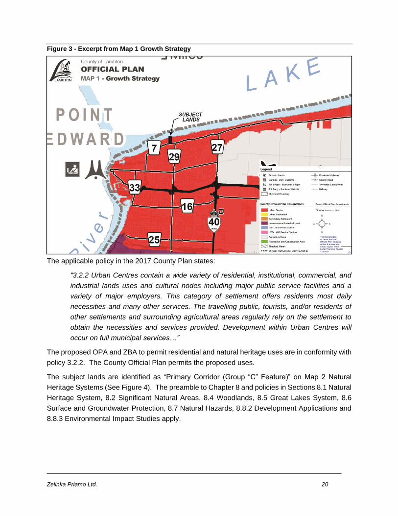
Zelinka Priamo Ltd. 20
Figure 3 - Excerpt from Map 1 Growth Strategy
The applicable policy in the 2017 County Plan states:
“3.2.2 Urban Centres contain a wide variety of residential, institutional, commercial, and
industrial lands uses and cultural nodes including major public service facilities and a
variety of major employers. This category of settlement offers residents most daily
necessities and many other services. The travelling public, tourists, and/or residents of
other settlements and surrounding agricultural areas regularly rely on the settlement to
obtain the necessities and services provided. Development within Urban Centres will
occur on full municipal services…”
The proposed OPA and ZBA to permit residential and natural heritage uses are in conformity with
policy 3.2.2. The County Official Plan permits the proposed uses.
The subject lands are identified as “Primary Corridor (Group “C” Feature)” on Map 2 Natural
Heritage Systems (See Figure 4). The preamble to Chapter 8 and policies in Sections 8.1 Natural
Heritage System, 8.2 Significant Natural Areas, 8.4 Woodlands, 8.5 Great Lakes System, 8.6
Surface and Groundwater Protection, 8.7 Natural Hazards, 8.8.2 Development Applications and
8.8.3 Environmental Impact Studies apply.
Zelinka Priamo Ltd. 21
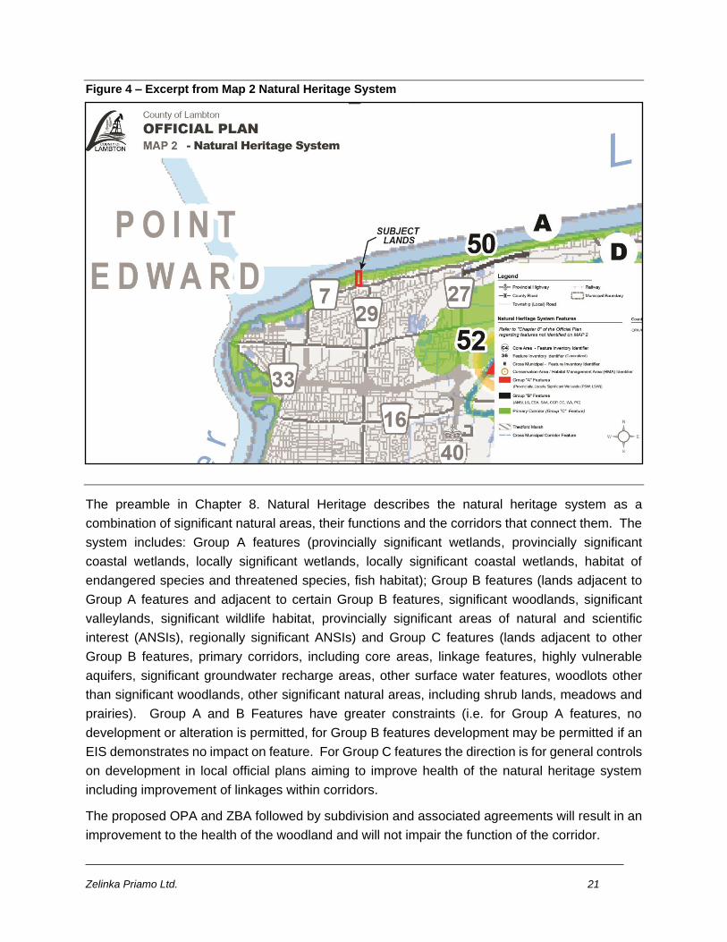
Figure 4 – Excerpt from Map 2 Natural Heritage System
The preamble in Chapter 8. Natural Heritage describes the natural heritage system as a
combination of significant natural areas, their functions and the corridors that connect them. The
system includes: Group A features (provincially significant wetlands, provincially significant
coastal wetlands, locally significant wetlands, locally significant coastal wetlands, habitat of
endangered species and threatened species, fish habitat); Group B features (lands adjacent to
Group A features and adjacent to certain Group B features, significant woodlands, significant
valleylands, significant wildlife habitat, provincially significant areas of natural and scientific
interest (ANSIs), regionally significant ANSIs) and Group C features (lands adjacent to other
Group B features, primary corridors, including core areas, linkage features, highly vulnerable
aquifers, significant groundwater recharge areas, other surface water features, woodlots other
than significant woodlands, other significant natural areas, including shrub lands, meadows and
prairies). Group A and B Features have greater constraints (i.e. for Group A features, no
development or alteration is permitted, for Group B features development may be permitted if an
EIS demonstrates no impact on feature. For Group C features the direction is for general controls
on development in local official plans aiming to improve health of the natural heritage system
including improvement of linkages within corridors.
The proposed OPA and ZBA followed by subdivision and associated agreements will result in an
improvement to the health of the woodland and will not impair the function of the corridor.
Zelinka Priamo Ltd. 22
Section 8.1 Natural Heritage System provides direction to local municipalities for identifying and
protecting natural heritage features and encouragement for the development of approaches to re-
establishing connections in corridors e.g. using buffer strips, conservation easements, land
dedications through planning applications, stewardship programs, and the preparation of
environmental impact statements where required.
The EIS prepared by NRSI proposes stewardship and protective zoning for the woodlot. Details
of the woodlot management will be negotiated at the subdivision review stage in the process.
Applicable policies from 8.1 Natural Heritage System are:
8.1.1 The County Natural Heritage System is comprised of Core Areas, Primary Corridors
and the other natural heritage features that are often located within and form the Linkages
within these Core Areas and Corridors….
8.1.2 Group A and B natural heritage features identified on Map 2 or otherwise identified
by the Natural Heritage policies of Chapter 8 are to be considered as overlays to the
designations on Map 1. Corridors and core areas on Map 2 are provided for information
only and are not considered land designations (emphasis added). Despite the designation
lands may have on Map 1 and the Growth Strategy, development of lands will be generally
directed away from Group A and B features and/or subject to such evaluations and
conditions as required by the Natural Heritage policies (see policy 8.8.3.8 also).
(8.8.3.8 Notwithstanding that an environmental impact study or other evaluation may show
no negative impacts, development must also comply with the policies of the applicable
land use designation on Map 1.)
8.1.3 Primary Corridors generally represent the stronger existing connections between
natural heritage areas, particularly core areas, and follow major watercourses and the
lakeshore. Many corridors cross municipal boundaries and are locally and regionally
important. Local municipalities should identify Primary Corridors in local official plans and
zoning by-laws using Map 2 as a guide, having regard for policy 8.1.12.
8.1.4 Local municipalities will develop policies to protect and improve Group A and B
features of the Natural Heritage System and should identify and protect Group C features
and other features of local significance. Group A and B natural heritage features identified
on Map 2 or specifically described in this Plan (e.g. significant woodlands) will be identified
in local land use maps and schedules.
8.1.5 Natural Heritage System feature boundaries shown on Map 2 are schematic. The
County recognizes that where Natural Heritage Corridors occur through urban
communities, the corridor boundary will be more specifically defined in the local official
plan and zoning by-law to reflect the natural hazards, natural heritage features, and land
uses that exist along the corridors.
The subject lands are in the Primary Corridor. Corridors are not land use designations and are
provided for information purposes. Where development is generally directed away from Group A
Zelinka Priamo Ltd. 23
and B features, development is not specifically directed away from the corridors, and Group C
feature.
City of Sarnia Official Plan policies and Zoning are described in the following sections of this
report.
8.1.9 The County and local municipalities may require development applications within or
adjacent to lands designated as part of the Natural Heritage System to be accompanied
by an Environmental Impact Study, as set out in Section 8.8.3, to evaluate features and
determine what impact that the development may have or is expected to have on Natural
Heritage Features and their functions. Nothing in this policy is intended to contravene any
provincial or federal requirements or permit development in a feature within which
development is prohibited.
8.1.10 Where an Environmental Impact Study has been completed, the Approval Authority
must be satisfied that the evaluation demonstrates that there will be no negative impacts
on the natural features or their ecological functions, including whether impacts can be
satisfactorily mitigated so that there is no net negative impact.
An EIS was prepared in support of the proposed OPA and ZBA and was reviewed by the SCRCA.
The EIS determined that there is significant woodland and prescribed mitigation including
replacement of significant woodland. The SCRCA advised replacement of significant woodlot if
the City approved the application.
8.1.11 The County encourages stewardship programs by private and public groups that
assist the landowner in the establishment, maintenance, and improvement of the Natural
Heritage System, Corridors, and the information base that describes them within Lambton
County. Landowners are encouraged to preserve and improve, where possible, the unique
species and habitat found in natural heritage areas. The County may participate with other
agencies in establishing, maintaining and improving a data base on Natural Heritage
features.
A substantial area is proposed for environmental protection. Future land owners will be required
by the proposed zoning and agreements to employ best practice woodlot management on the
areas proposed for environmental protection.
8.1.15 Land use policies and decisions must consider potential negative environmental
impacts and opportunities for maintaining and integrating linkages and related functions
among groundwater features, hydrologic functions, natural heritage features and areas,
and surface water features including shoreline areas.
Provided that the mitigation measures contained in the EIS are employed the woodland significant
ecological functions will be maintained.
Applicable policies from Section 8.2 Significant Natural Areas are:
Zelinka Priamo Ltd. 24
8.2.1 Significant natural areas within the County natural heritage system include
provincially and locally significant wetlands, including coastal wetlands; habitat of
endangered species and threatened species; fish habitat; provincially and regionally
significant areas of natural and scientific interest (ANSIs); significant woodlands;
significant valleylands; Great Lakes system shorelines; highly vulnerable aquifers,
significant groundwater recharge areas, and significant wildlife habitat. Other components
of the natural heritage system that may be important include, but are not limited to, surface
water features, meadows, prairies, and shrub lands.
8.2.2 Despite the designation lands may have on Map 1, development and the creation of
new lots will generally be directed away from Significant Natural Areas.
c) Development within the Group C features described in the introduction to Chapter 8 will
be subject to such provisions as contained in the local Official Plans.
8.2.2.1 Adjacent lands widths and the features to which they apply are described at
sections 8.2.9 (for Areas of Natural and Scientific Interest), 8.3.3 (for wetlands) , 8.4.3
(120 m for significant woodlands), and 8.8.3.6 (EIS required for development on adjacent
lands).
The significant woodland is a significant natural area in the County natural heritage system.
Although development and lot creation will generally be directed away from significant natural
areas, development and lot creation is not specifically prohibited in natural areas. The Sarnia
Official Plan contains provisions for development in significant woodlands and adjacent lands.
Applicable policies from Section 8.4 Woodlands are:
8.4.1 Local municipalities are encouraged to protect woodlots. Local municipalities will
identify significant woodlands in their official plans and zoning by-laws using the criteria
and mapping contained in the draft Lambton County Natural Heritage Study (2014).
8.4.2 Significant woodlands include any forested area that:
e) is 0.5 hectares or greater in size and
ii) provides linkage (a "stepping stone") between (is in a line between and within
120 metres of) two or more significant woodlands that are separated by more than
120 metres of each other;
iv) is located above a highly vulnerable aquifer or significant groundwater recharge
area;
vi) has uncommon characteristics such as unique species composition; a rare
vegetation community (NHIC provincial ranking of S1, S2, or S3); rare, uncommon,
or restricted woodland plant species habitat; older woodlands, or larger tree size
structure; or
Zelinka Priamo Ltd. 25
8.4.3 Adjacent lands include any lands within 120 metres of any significant woodland that
is coincident with a core area, Life Science Area, Carolinian Canada site, Crown Game
Preserve, Wilderness Area, Environmentally Sensitive Area, or Special Appendix Area (as
identified in the Map 2 feature inventory) or is known to meet criteria 8.4.2 b), d), or e) v)
or vi).
The woodland is significant for the above noted features and functions, according to the EIS
prepared by NRSI. The subject lands contain adjacent lands and meet criteria 8.4.2 e) vi.
8.4.4 Development will generally be directed outside of the dripline of significant
woodlands and adjacent lands unless it has been demonstrated through an Environmental
Impact Study that there will be no negative impacts on the natural features and their
ecological functions.
8.4.7 The cutting of trees is regulated by the provisions of the County of Lambton
Woodlands Conservation By-law, or successor, as amended.
8.4.10 Where forest cover has been removed and is to be replaced as a condition of an
environmental impact study and/or development approval, the use of a variety of
indigenous species of vegetation is encouraged. Restoration work should be required at
a rate of twice the area of forest cover that was removed. Preference will be given to
replacing the trees at the same site and/or within the same corridor in the Natural Heritage
system. The replacement tree stock should consist of indigenous species where quality
stock is available and be maintained by the proponent to the free to grow stage. Long-
term management of these replacement trees will comply with the County Woodlands
Conservation By-law.
8.4.12 When considering development proposals including plans of subdivision, the
Approval Authority may require that the owner enter into an agreement whereby:
a) only such trees that would directly impede the construction of buildings and services
may be removed and, if so, they will be replaced with trees of similar species and of
sufficient maturity to improve the appearance of the subdivision when complete;
b) a reasonable number of trees and/or other suitable vegetation per lot may be required
regardless of the state of the area prior to being subdivided or developed;
c) existing trees which are not removed will be adequately protected during the
construction process, and the roots protected to ensure continued growth;
A woodland dripline buffer from the north end of the FOD1 feature cannot be accommodated.
However, impacts to adjacent woodland features can be addressed through mitigation measures
such as tree protection fencing or signage, rear yard species plantings, and landowner information
materials, according to the EIS.
Woodland that is proposed to be removed (approximately 2256 m2) will be replaced in accordance
with the requirements of policy 8.4.10. Proposed replacement is discussed in detail in the EIS.
Zelinka Priamo Ltd. 26
As previously stated, under the County of Lambton Woodlands Conservation By-law, it is our
understanding that activities for personal use such as tree cutting for firewood, clearing for walking
trails and clearing undergrowth are possible without approvals under the By-law. The proposed
ZBL and mitigation measures will provide regulation and agreements to protect the functions of
the woodlot. Appropriate tree protection measures can be included within the future subdivision
agreement.
Applicable policies from Section 8.5 Great Lakes System are:
8.5.2 The Conservation Authorities have prepared Shoreline Management Plans which
recognize:
a) that shoreline processes occur as part of a natural system and must be considered
when reviewing land use decisions and practices;
c) the use of shoreline management principles that recognize the two distinct Lake Huron
shoreline reaches of Grand Bend to Kettle Point; and Kettle Point to Sarnia.
The Shoreline Management Plans address the issues of flooding, erosion, storm damage,
dynamic beach instability, shore processes, and shoreline management options for shore
protection. Through regulations under the Conservation Authorities Act, Conservation
Authorities regulate certain types and aspects of development within the shoreline
management areas with respect to erosion and flooding hazards. Local municipal official
plans should support implementation of the Shoreline Management Plans, addressing
those aspects of development falling outside the Conservation Authorities' regulations,
including natural heritage functions.
No development is proposed in Shoreline Management Areas 1 and 2. The Sarnia Official Plan
and Zoning By-law support implementation of the Shoreline Management Plan. Furthermore,
permits are required from the SCRCA.
Section 8.6 Surface and Ground Water Protection provides for the protection of ground water
aquifers. The subject lands are located in an area identified as Highly Vulnerable Aquifer in
Appendix Map A Source Protection Plans. The proposed residential development and associated
works will not generate materials hazardous to the aquifer. According to the SCRCA the subject
land is not considered a vulnerable area for groundwater.
Applicable policies from Section 8.7 Natural Hazards are:
8.7.1 New development will generally be directed away from areas with known or
suspected natural hazards. Natural hazards include: a) flooding, erosion, and dynamic
beach hazards related to the Great Lakes System
8.7.12 With respect to areas of flooding and erosion hazards, the meaning of
"development" shall include any new lot or lot boundary adjustment that would cause or is
likely to cause a change or intensification of land use, the construction of buildings or
structures (including accessory structures), or site alteration, any of which is not
Zelinka Priamo Ltd. 27
appropriate for and/or fails to address the hazard as required by the Natural Hazard
policies. This could include doing so by reason of eliminating opportunities to locate or
relocate uses to outside of hazard lands.
8.7.13 Development setbacks are encouraged as the preferred method for protecting new
development in natural hazard areas as opposed to relying on structural or nonstructural
protection measures that require maintenance and upgrading over time.
Development is proposed outside of the flooding and erosion hazards that exist on the Lake Huron
shoreline. The existing cottage is located within the hazard (and in the above noted Shoreline
Management Areas) and will be removed. Development envelopes are located outside of the
erosion hazard limit.
Applicable policy from section 8.8 Implementation Tools for Natural Heritage is:
8.8.1 Stewardship
8.8.1.1 Stewardship is the most important method of maintaining, restoring, and improving
the natural heritage system. The County supports a wide variety of stewardship options to
assist and encourage landowners to manage their natural resources. These programs
should be established in partnership with land owners, to meet their needs. These
programs can include land owner contracts, conservation easements, land trusts, tax
incentives, and rights of way to preserve, improve and access natural corridors.
The proposed Zoning By-law permits only conservation and woodlot use in the rear yards of lots
1, 2, 3 and 4. Future homeowners will be provided information/educational brochures that
describe the importance of maintaining the existing woodland features in accordance with best
management practices.
8.8.3 Environmental Impact Studies
Policies:
8.8.3.1 Where an Environmental Impact Study is required in order to assess land
development proposals for lands that encroach into or are adjacent to Provincially or
Locally Significant environmental features, the study must demonstrate that there will be
no negative impact on the natural features or on the ecological functions for which the
area is identified. The study may determine the need to incorporate a buffer or setbacks
from the natural feature into the proposed development's site layout as a condition of
proceeding.
8.8.3.2 This Plan does not intend to imply that all impacts are negative. Also, this Plan
does not preclude the use of mitigation to prevent, modify, or alleviate anticipated impacts.
An Environmental Impact Study must recommend whether a development should or
should not proceed with or without alteration (redesign) or mitigation and must recommend
any alterations (redesign) or mitigation measures that are necessary for a development to
cause no net negative effect to the natural feature or its functions.
Zelinka Priamo Ltd. 28
8.8.3.3 The Approval Authority must be satisfied that the Environmental Impact Study has
been completed by a qualified individual and is thorough in assessing existing conditions
and potential impacts. In this regard, the Approval Authority may use external agencies
and groups to assist in the review of such studies.
8.8.3.4 Environmental Impact Studies will be guided by the following stages:
Stage 1 - Review (a preliminary ecological site assessment) will be completed to verify the
location and state of the environmental feature and its function and may subsequently
refine the boundaries of components of the Natural Heritage System. MNRF should be
consulted regarding the Endangered Species Act, 2007 at this stage for an initial
information request and Species at Risk screening. This stage of review is intended to
confirm the feature and function and the need, if any, to proceed to subsequent stages of
review.
Stage 2 - Review will assess the potential impacts of the proposed development to the
Natural Heritage System components by evaluating the sensitivity and overall condition of
the Natural Heritage System component and the scale of development. This review stage
is intended to be more comprehensive than Stage 1 and will require considerable more
detail regarding the understanding of the Natural Heritage System. The result of this
review will determine if development can occur in some form. Natural hazards will also be
evaluated within this stage of investigation.
Stage 3 - Review will provide alternative methods and/or measures for mitigation of
potential environmental effects of the proposed development
8.8.3.6 An Environmental Impact Study will generally be required for development on
lands adjacent to natural heritage features. Adjacent lands are those within 120 metres of
an identified Group A or B feature unless an exception or alternative requirement has been
given in this Plan from a specific type of feature (e.g. - Sections 8.2.2.1, 8.2.9, 8.3.3, and
8.4.3). Distances may also be reduced on a case by case basis based on the scale of the
proposed development, the nature of the feature and the likelihood that there would be a
negative impact on the feature. Adjacent land widths are derived from the Natural Heritage
Reference Manual, the province's guidelines on how to apply the Provincial Policy
Statement's natural heritage policies. In the case of wetlands, adjacent land widths are
also derived from the Conservation Authority Wetland Policy.
8.8.3.8 Notwithstanding that an environmental impact study or other evaluation may show
no negative impacts, development must also comply with the policies of the applicable
land use designation on Map 1.
The EIS prepared by NRSI dated November 19, 2019 determined that significant woodland was
located on parts of the subject lands. Development is proposed in the woodland. The EIS
recommends mitigation measures including matters such as replacement of woodland and
conservation agreements. The SCRCA reviewed the EIS and appears to be satisfied that the
Zelinka Priamo Ltd. 29
assessment was prepared in accordance with accepted practice for the preparation of an EIS.
The SCRCA advised that if the proposal is to be approved by the City, replacement and best
management practices of the woodland should be required. The EIS was prepared in compliance
with the County Plan Environmental Impact Studies policy.
Based on the above the proposed OPA and ZBA are in conformity with the applicable policies in
the Lambton County Official Plan.
5.3 THE CITY OF SARNIA OFFICIAL PLAN
The City of Sarnia Official Plan was adopted by City Council on June 30, 2014, approved as
modified by the County of Lambton on February 6, 2015, and approved by Order of the Ontario
Municipal Board on July 15, 2016.
City Structure Plan
The subject lands are identified as Stable Residential Area along Lakeshore Road and Stable
Residential Area and Natural Heritage System along the Lake Huron Shoreline on Map 1 City
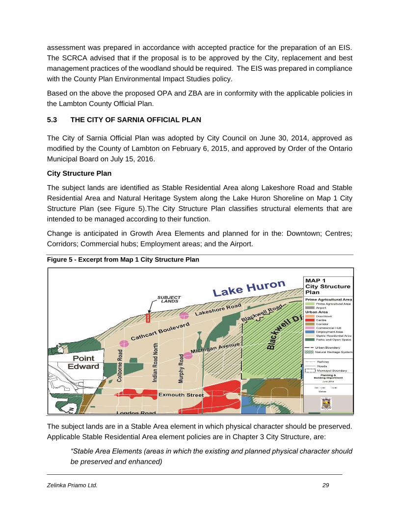
Structure Plan (see Figure 5).The City Structure Plan classifies structural elements that are
intended to be managed according to their function.
Change is anticipated in Growth Area Elements and planned for in the: Downtown; Centres;
Corridors; Commercial hubs; Employment areas; and the Airport.
Figure 5 - Excerpt from Map 1 City Structure Plan
The subject lands are in a Stable Area element in which physical character should be preserved.
Applicable Stable Residential Area element policies are in Chapter 3 City Structure, are:
“Stable Area Elements (areas in which the existing and planned physical character should
be preserved and enhanced)
Zelinka Priamo Ltd. 30
• Stable residential areas
• Parks and open spaces
Sarnia’s natural heritage system is an environmental element within the municipal
boundary that requires particular consideration and attention by those making land-use
decisions.
Continuous regeneration and wise management are essential to long-term sustainability.
Directing growth to appropriate areas helps ensure continual renewal and revitalization;
promotes the more efficient and cost-effective use of infrastructure; and protects natural
resources, public health and safety, and the character of stable neighbourhoods.
The City Structure on Map 1 is sufficient to accommodate land needs over the planning
period and is not expected to change over the life of this Plan; any change shall be
considered only after a municipal comprehensive review.”
The subject lands are part of the Stable Residential Area on Map 1. The Structure Plan
contemplates residential development in Stable Residential Areas subject to hazard and natural
heritage considerations along the Lakeshore. The lands are Zoned Urban Residential 1 with
shoreline management and hazard overlays. The existing zoning permits large lot single
detached residential development provided compliance with shoreline management and flooding
and erosion hazards regulations.
The physical character of the area is low density large lot single detached dwellings with
substantial urban tree canopy and includes large lot single detached dwellings backing on the
Lake Huron shoreline. Commercial, recreational, parks and institutional uses are within walking
distance of the subject lands and the area has the full range of utility services. Full municipal
services and regular transit service is available. The Lake Huron Shoreline presents a highly
desirable residential environment provided development occurs outside hazards associated with
the shoreline and natural heritage features and ecological functions are conserved. The proposed
ZBA provides an Environmental Protection Zone to preserve features and ecological functions.
The proposed Urban Residential 1 Zone applies in the surrounding general area. The proposed
OPA and ZBA would allow development that is sensitive to the abutting residential development,
outside of the shoreline hazard and conserves woodland features and functions. The proposed
OPA and ZBA maintain the Structure Plan general intent which contemplates compatible
residential development in a stable residential area, provided protection from shoreline hazards
and conservation of natural heritage features and ecological functions.
3.5. Intensification Outside Growth Areas
Within the urban area, most areas outside growth areas are existing and planned stable
residential areas and parks and open space that will develop, mature and gradually adapt
as the City evolves. Maintenance and enhancement of assets is a City priority in these
areas. Re-investment and upgrading will be encouraged through minor infilling and
Zelinka Priamo Ltd. 31
development that respect and reinforce the prevailing built form standards of height,
density and amenity.
The subject land is in a stable residential area. The significant woodland is an asset on the subject
lands. The proposed ZBL Environmental Protection Zone requires conservation of the woodlot
including maintenance and enhancement. The proposed development represents intensification
from one (1) dwelling unit to six (6) dwelling units, a minor infilling proposal, regulated by the
proposed Urban Residential 1 Zone. The UR1 Zone applies on surrounding lands and regulates
built form standards of height, density and amenity. Development regulated by the UR1 Zone will
respect and reinforce the prevailing single detached dwelling development in the area.
Agreements specifying appropriate maintenance and enhancement of the woodlot will occur at
the time of subdivision review.
3.6. Intensification Target Urban
Urban areas include built-up areas and greenfield areas. Built-up areas are the developed
portion of the urban area. Greenfield areas represent the undeveloped area between the
built-up area and the urban boundary. The built boundary represents the limits of the built-
up area for the purposes of this Plan.
Over the period covered by this Official Plan, a minimum of 40% of all new residential units
constructed within the City of Sarnia shall be constructed within the built boundary as
shown on Map 2. The County and City will monitor the number of units constructed within
and outside the built boundary to ensure conformity with this intensification target.
The proposed development is within the built boundary and will add new residential units planned
to be constructed within the built boundary.
Map 2 (See Figure 6) Settlement Boundaries identifies the Urban Boundary, the Built-up
Boundary, the Built-up Area, Residential and Non-Residential Greenfield Areas, Natural Areas
and Prime Agricultural Areas. The subject lands are within the Built-up Area. The proposed OPA
and ZBA will facilitate the construction of dwelling units in compliance with the minimum of 40%
new residential units to be constructed within the built boundary shown on Map 2
.
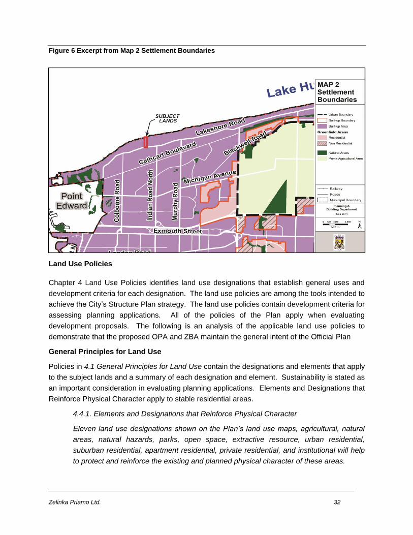
Zelinka Priamo Ltd. 32
Figure 6 Excerpt from Map 2 Settlement Boundaries
Land Use Policies
Chapter 4 Land Use Policies identifies land use designations that establish general uses and
development criteria for each designation. The land use policies are among the tools intended to
achieve the City’s Structure Plan strategy. The land use policies contain development criteria for
assessing planning applications. All of the policies of the Plan apply when evaluating
development proposals. The following is an analysis of the applicable land use policies to
demonstrate that the proposed OPA and ZBA maintain the general intent of the Official Plan
General Principles for Land Use
Policies in 4.1 General Principles for Land Use contain the designations and elements that apply
to the subject lands and a summary of each designation and element. Sustainability is stated as
an important consideration in evaluating planning applications. Elements and Designations that
Reinforce Physical Character apply to stable residential areas.
4.4.1. Elements and Designations that Reinforce Physical Character
Eleven land use designations shown on the Plan’s land use maps, agricultural, natural
areas, natural hazards, parks, open space, extractive resource, urban residential,
suburban residential, apartment residential, private residential, and institutional will help
to protect and reinforce the existing and planned physical character of these areas.
Zelinka Priamo Ltd. 33
Residents prize Sarnia’s stable residential areas, with their distinctive character, together
with local institutions, retail and services that serve their populations. These existing and
planned areas are differentiated by designation based on the type and scale of the
buildings in each area, yet share the need for contextual stability, better amenities and
environmental sustainability.
Maps 7 to 11 comprise the City’s Land Use Plan. The subject lands are designated Urban
Residential on Land Use Maps 7 (and 8) and as previously stated, are identified as Stable
Residential in the Natural Heritage System on Map 1 City Structure Plan.
The City’s natural heritage system is identified as natural areas, parks and open space.
These assets are to be protected and improved to provide respite and recreation for Sarnia
residents, and ecological and hydrological functions for the City as a whole.
Map 5 Natural Heritage identifies physiographic features, surface water features, natural area
types (A&B), natural hazards, public beach areas, petroleum pools and sewage lagoons. The
lands are identified as Natural Areas ‘Type B’ and Natural Hazards on Map 5.
Natural hazards include watercourses, floodplains and erosion prone areas. Policies for
these areas are intended to identify environmental constraints, respect ecological integrity
and address public health and safety.
Map 6 Natural Hazards identifies the Great Lakes System and Rivers and Stream Floodplains.
The lands are in the Shoreline Management Area on Map 6.
Stable Residential Areas/Urban Residential/Natural Hazards
The subject lands are in a stable residential area and are designated Urban Residential and
Natural Hazards on Map 7 Land use Plan (See Figure 7). Policies from Section 4.4 Stable
Residential Areas, Section 4.4.2 Urban Residential and Section 4.3.2 Natural Hazards apply to
the subject lands.
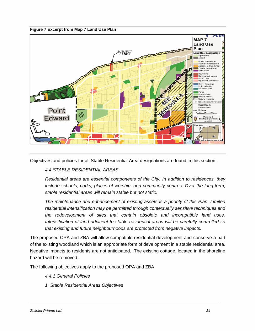
Zelinka Priamo Ltd. 34
Figure 7 Excerpt from Map 7 Land Use Plan
Objectives and policies for all Stable Residential Area designations are found in this section.
4.4 STABLE RESIDENTIAL AREAS
Residential areas are essential components of the City. In addition to residences, they
include schools, parks, places of worship, and community centres. Over the long-term,
stable residential areas will remain stable but not static.
The maintenance and enhancement of existing assets is a priority of this Plan. Limited
residential intensification may be permitted through contextually sensitive techniques and
the redevelopment of sites that contain obsolete and incompatible land uses.
Intensification of land adjacent to stable residential areas will be carefully controlled so
that existing and future neighbourhoods are protected from negative impacts.
The proposed OPA and ZBA will allow compatible residential development and conserve a part
of the existing woodland which is an appropriate form of development in a stable residential area.
Negative impacts to residents are not anticipated. The existing cottage, located in the shoreline
hazard will be removed.
The following objectives apply to the proposed OPA and ZBA.
4.4.1 General Policies
1. Stable Residential Areas Objectives
Zelinka Priamo Ltd. 35
The lands identified as stable residential areas on Map 1 represent the areas that provide
for existing and future stable residential communities.
Stable residential areas are to be developed and be maintained as physically stable areas
that may mature and adapt gradually for residential purposes as the City evolves. New
development and reinvestment is to achieved by residential development that reinforces
the prevailing built form standards found in, or planned for, each neighbourhood. In
support of these goals, the City shall:
f) encourage infill and redevelopment in appropriate locations;
g) ensure any permitted development proceeds in such a manner so as not to impose a
financial burden on the City or municipal taxpayers; and
h) enforce standards to ensure that all properties are well maintained and in compliance
with housing, building, and health codes.
As discussed previously, amenities and services are available in the area for additional
compatible residential development. Full municipal services are available. Currently the woodlot
is not well maintained with apparent debris and refuse dumping. The proposed OPA and ZBA
will allow infill at an appropriate location with full municipal services and will require stewardship
of the woodland.
4.4.1.2. Stable Residential Area Land Use Designations
A variety of residential uses are accommodated through five stable residential area land
use designations: urban residential, suburban residential, apartment residential, private
residential, recreational residential and institutional. These designations provide for a full
range of housing types, forms and densities.
The subject lands are designated Urban Residential. The proposed OPA and ZBA will allow a
low density housing type and form and at a density that is typical in the area.
4.4.1.3. Development and Redevelopment within Stable Residential Areas Development
and redevelopment within stable residential areas shall respect and reinforce the existing
and planned physical character of buildings, streetscapes and open space patterns in
these areas, and shall be undertaken by means of planned subdivision development, or
where a plan of subdivision is not required, by severance of lands to make the most
efficient use of municipal services.
The OPA and ZBA facilitate a land division proposal for single detached residences and
conservation of the woodland by way of plan of subdivision. The proposal respects and reinforces
the physical character of the area. Full municipal services are available.
Zelinka Priamo Ltd. 36
4.4.1.6. Transportation within Stable Residential Areas
The design and layout of roads in new subdivisions and/or areas subject to severance
shall be well-integrated with the existing road network and shall not preclude or prevent
the orderly and efficient integration of future development on abutting vacant or underused
lands. Access roads to such parcels shall be dedicated as public rights-of-way.
The extension of Tudor Close West is integrated with the existing road pattern and will not
preclude future development. The extension will be dedicated as a public right-of way.
4.4.1.7. Environmental Sustainability in Stable Residential Areas
The City will promote environmental sustainability in stable residential areas through
naturalization and landscaping improvements, tree planting and preservation, sustainable
technologies for stormwater management, energy efficiency and programs for reducing
waste.
The City shall encourage housing designs that offer improved energy or water-use
efficiency or alternative forms of heating, in order to reduce municipal expenditures and
lower costs to purchasers.
The OPA and ZBA will enable managed naturalization, tree planting and preservation on the
woodland. Stormwater management and other requirements will be in accordance with municipal
requirements. Sustainable technologies are available to future lot owners if they choose to
employ such technologies.
4.4.2 Urban Residential designation
The urban residential designation reflects the City’s existing and planned lower scale
residential neighbourhoods, as well as parks, schools and local institutions. They contain
a full range of residential uses within lower-scale buildings. Physical changes to urban
residential designations must be sensitive, gradual and generally ‘fit’ the existing and
planned physical character. A key objective of this Plan is that new development respects
and reinforces the general physical patterns in stable residential areas.
The OPA and ZBA facilitates development that reflects the existing stable residential area. The
proposal fits the existing physical character of the area and reinforces the general physical
patterns in the area.
4.4.2.1. Permitted Uses
Urban residential designations apply to physically stable areas made up of low-density
housing types, such as single and semi-detached dwellings, group homes, duplexes,
triplexes and townhouses, including building conversions to such uses. Parks, minor
institutions, home occupations, bed and breakfasts, cultural and recreational facilities, and
Zelinka Priamo Ltd. 37
small-scale retail, service and office uses are also provided for in the urban residential
designation.
The proposed single detached dwellings are a permitted use in the Urban Residential designation.
4.4.2.2. Urban Residential Development Criteria
Development in the urban residential designation shall respect and reinforce the existing
and/or planned physical character of the neighbourhood, including in particular:
a) patterns of streets, blocks and lanes, parks and public building sites;
b) size and configuration of lots;
c) prevailing building type(s);
d) height, massing, and scale of nearby residential properties;
e) setbacks of buildings from the street or streets;
f) prevailing patterns of rear and side yard setbacks and landscaped open space;
g) continuation of special landscape or built-form features that contribute to the unique
character of a neighbourhood; and
h) conservation of heritage buildings, structures and landscapes.
No changes shall be made through rezoning, minor variance, consent or any other public
action that do not reinforce and respect the prevailing physical character of the
neighbourhood.
5. Zoning By-laws
It is the intent of this Plan to protect stable residential areas in the implementing Zoning
By-law through the establishment of zoning categories that recognize established and
planned land uses, land use patterns and development standards. Zoning by-laws shall
contain numerical site standards for matters such as building type and height, density, lot
sizes, lot depths, lot frontages, parking, building setbacks from lot lines, landscaped open
space and any other performance standard to ensure that new development is consistent
with the physical character of established or planned residential neighbourhoods.
A cul-de-sac street pattern is evident in the area and is dictated on the subject lands by the
configuration of the lot. The cul-de-sac allows doubled loaded development at the north end of a
long narrow lot. The proposed lot sizes are larger than typical in the area for the purpose of
preserving part of the woodland. The area and frontage of the lots proposed to be developed for
single detached dwellings is comparable to the lot areas and frontages on Tudor Road Close and
on Lakeshore Road. Height, massing, scale, setbacks, yards, and area for landscaped open
space will be regulated by the proposed Urban Residential 1 Zone. The proposed Environmental
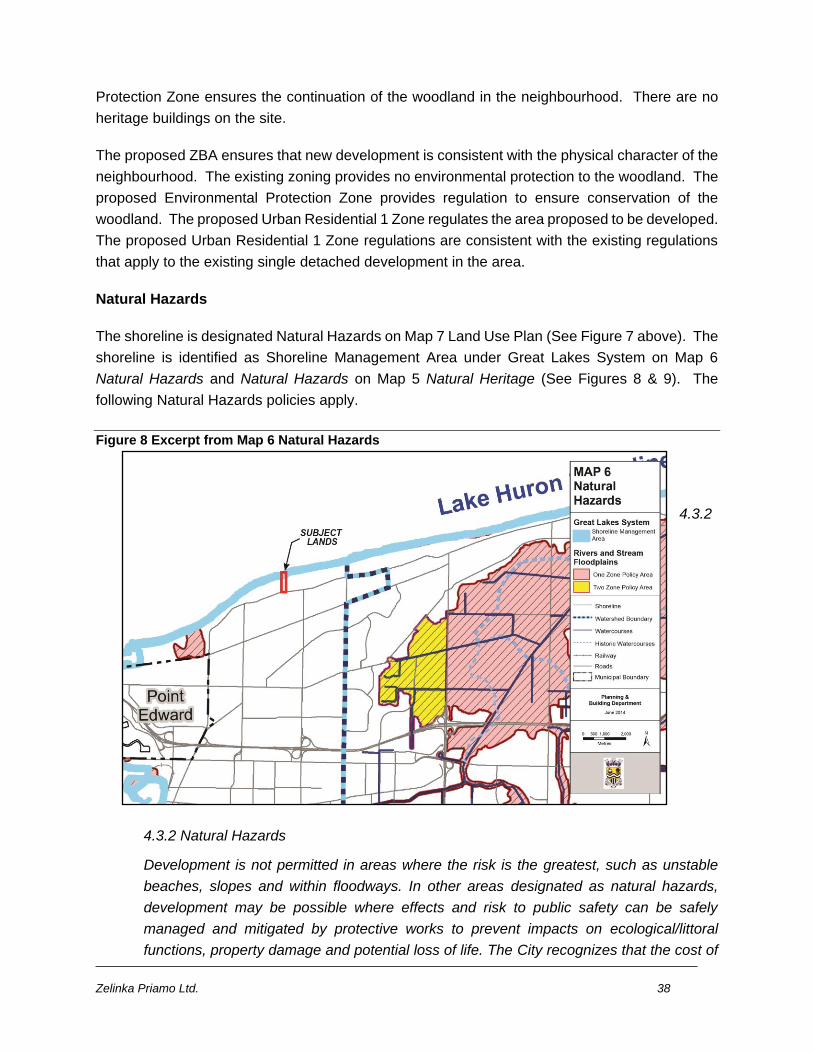
Zelinka Priamo Ltd. 38
Protection Zone ensures the continuation of the woodland in the neighbourhood. There are no
heritage buildings on the site.
The proposed ZBA ensures that new development is consistent with the physical character of the
neighbourhood. The existing zoning provides no environmental protection to the woodland. The
proposed Environmental Protection Zone provides regulation to ensure conservation of the
woodland. The proposed Urban Residential 1 Zone regulates the area proposed to be developed.
The proposed Urban Residential 1 Zone regulations are consistent with the existing regulations
that apply to the existing single detached development in the area.
Natural Hazards
The shoreline is designated Natural Hazards on Map 7 Land Use Plan (See Figure 7 above). The
shoreline is identified as Shoreline Management Area under Great Lakes System on Map 6
Natural Hazards and Natural Hazards on Map 5 Natural Heritage (See Figures 8 & 9). The
following Natural Hazards policies apply.
Figure 8 Excerpt from Map 6 Natural Hazards
4.3.2
4.3.2 Natural Hazards
Development is not permitted in areas where the risk is the greatest, such as unstable
beaches, slopes and within floodways. In other areas designated as natural hazards,
development may be possible where effects and risk to public safety can be safely
managed and mitigated by protective works to prevent impacts on ecological/littoral
functions, property damage and potential loss of life. The City recognizes that the cost of
Zelinka Priamo Ltd. 39
maintaining protection works often requires on-going expensive maintenance and long
term capital investment commitments.
4.3.2.1 Natural Hazards
Development shall avoid natural hazards. Natural hazards are areas with environmental
constraints designated on Map 6 including:
• flooding, erosion and dynamic beach hazards related to the Great Lakes System;
Lots five (5) and six (6) are affected by shoreline flooding and erosion hazards. A number of
iterations of the concept plan have been prepared. Building envelopes on an earlier concept plan
were located within the erosion hazard limit. Building envelopes on the present concept are
located outside of the shoreline erosion and hazard limit according to the flooding and erosion
calculations prepared by Shoreplan Engineering. The shoreline erosion limit is identified on the
concept plan in Appendix C.
4.3.2.2. General Policies
No alteration to a watercourse and no placing or removal of any fill of any kind whether
originating on the site or elsewhere shall be permitted in lands designated as natural
hazards unless such action is approved by the City or where fill regulations apply. The
Conservation Authority Regulation text governs the extent of the Regulation where
mapping is in dispute. The City may enact a Site Alteration By-Law under the authority of
the Municipal Act to regulate such actions.
For any construction proposed within a natural hazard, the proponent must obtain written
permission from the St. Clair Region Conservation Authority before the City will issue a
building permit.
The subject lands are within the SCRCA regulated area. Permits are required from the SCRCA
for any construction within the regulated area.
4.3.2 3. Natural Hazards Associated with the Great Lakes System
Within the City, the Great Lakes System includes Lake Huron and the St. Clair River and
their associated shorelines, dynamic beaches, and flooding and erosion susceptible
areas. Within these areas, sand and sediment are constantly moving, and water levels,
wind, soil type, degree of slope, rainfall, storms, dunes, bank stability and vegetation vary.
3.1 Lake Huron Shoreline
These policies apply to lands along the Lake Huron Shoreline that are susceptible to
flooding, erosion and dynamic beach hazards according to the Shoreline Management
Plan prepared by the St. Clair Region Conservation Authority (SCRCA). Shoreline
Management Area 1 is the high hazard area and Shoreline Management Area 2 is the
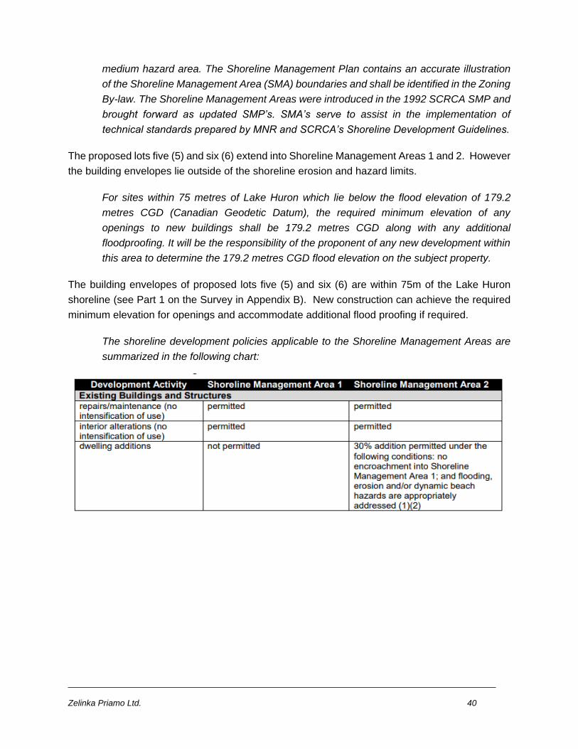
Zelinka Priamo Ltd. 40
medium hazard area. The Shoreline Management Plan contains an accurate illustration
of the Shoreline Management Area (SMA) boundaries and shall be identified in the Zoning
By-law. The Shoreline Management Areas were introduced in the 1992 SCRCA SMP and
brought forward as updated SMP’s. SMA’s serve to assist in the implementation of
technical standards prepared by MNR and SCRCA’s Shoreline Development Guidelines.
The proposed lots five (5) and six (6) extend into Shoreline Management Areas 1 and 2. However
the building envelopes lie outside of the shoreline erosion and hazard limits.
For sites within 75 metres of Lake Huron which lie below the flood elevation of 179.2
metres CGD (Canadian Geodetic Datum), the required minimum elevation of any
openings to new buildings shall be 179.2 metres CGD along with any additional
floodproofing. It will be the responsibility of the proponent of any new development within
this area to determine the 179.2 metres CGD flood elevation on the subject property.
The building envelopes of proposed lots five (5) and six (6) are within 75m of the Lake Huron
shoreline (see Part 1 on the Survey in Appendix B). New construction can achieve the required
minimum elevation for openings and accommodate additional flood proofing if required.
The shoreline development policies applicable to the Shoreline Management Areas are
summarized in the following chart:
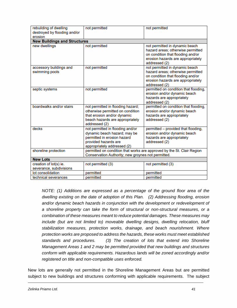
Zelinka Priamo Ltd. 41
NOTE: (1) Additions are expressed as a percentage of the ground floor area of the
dwelling existing on the date of adoption of this Plan. (2) Addressing flooding, erosion
and/or dynamic beach hazards in conjunction with the development or redevelopment of
a shoreline property can take the form of structural or non-structural measures, or a
combination of these measures meant to reduce potential damages. These measures may
include (but are not limited to) moveable dwelling designs, dwelling relocation, bluff
stabilization measures, protection works, drainage, and beach nourishment. Where
protection works are proposed to address the hazards, these works must meet established
standards and procedures. (3) The creation of lots that extend into Shoreline
Management Areas 1 and 2 may be permitted provided that new buildings and structures
conform with applicable requirements. Hazardous lands will be zoned accordingly and/or
registered on title and non-compatible uses enforced.
New lots are generally not permitted in the Shoreline Management Areas but are permitted
subject to new buildings and structures conforming with applicable requirements. The subject
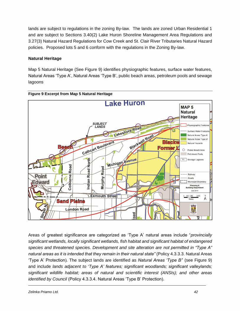
Zelinka Priamo Ltd. 42
lands are subject to regulations in the zoning By-law. The lands are zoned Urban Residential 1
and are subject to Sections 3.40(2) Lake Huron Shoreline Management Area Regulations and
3.27(3) Natural Hazard Regulations for Cow Creek and St. Clair River Tributaries Natural Hazard
policies. Proposed lots 5 and 6 conform with the regulations in the Zoning By-law.
Natural Heritage
Map 5 Natural Heritage (See Figure 9) identifies physiographic features, surface water features,
Natural Areas ‘Type A’, Natural Areas ‘Type B’, public beach areas, petroleum pools and sewage
lagoons
Figure 9 Excerpt from Map 5 Natural Heritage
Areas of greatest significance are categorized as ‘Type A’ natural areas include “provincially
significant wetlands, locally significant wetlands, fish habitat and significant habitat of endangered
species and threatened species. Development and site alteration are not permitted in “Type A”
natural areas as it is intended that they remain in their natural state” (Policy 4.3.3.3. Natural Areas
‘Type A’ Protection). The subject lands are identified as Natural Areas ‘Type B’’ (see Figure 9)
and include lands adjacent to ‘Type A’ features; significant woodlands; significant valleylands;
significant wildlife habitat; areas of natural and scientific interest (ANSIs); and other areas
identified by Council (Policy 4.3.3.4. Natural Areas ‘Type B’ Protection).
Zelinka Priamo Ltd. 43
Natural heritage objectives and policies are found in section 4.3 Natural Heritage. Natural Areas
policies are found in section 4.3.3 Natural Areas.
The overarching aims of the natural heritage objectives in 4.3.1.2 Natural Heritage Objectives are
to identify natural areas and natural hazards and their ecological functions; protect, maintain,
enhance and restore the natural heritage system to the greatest extent feasible; fostering
stewardship of the natural heritage system; and monitoring and managing the natural heritage
system. Applicable policies are:
4.3.1 General Policies
4.3.1.1. Natural Heritage System
The City’s natural heritage system consists of core natural areas, linkages, landforms and
functions that together are recognized as essential to the maintenance of biological and
geological diversity, natural functions, viable species population and ecosystem
connectivity. The natural heritage system generally follows floodplains and woodlands,
and their associated ecological functions. The City’s natural heritage elements are
identified on Map 5 and include: natural areas, natural hazards, their hydrological and
ecological functions and linkages.
The subject lands are identified as an element in the City’s natural heritage system on Map 5. As
previously stated, the lands are designated Urban Residential and Natural hazards on Map 7
Land Use. The lands are zoned Urban Residential 1 with shoreline and hazard overlays.
Integrated management can contribute to ecosystem health, protect public health and
safety and improve community well-being. Development shall generally be directed away
from the natural heritage system.
4.3.1.2. Natural Heritage Objectives
It is the intent of this Plan to protect the City’s natural heritage resources by:
a) using watershed boundaries as the ecologically meaningful scale for planning;
The subject lands are in the St. Clair River Tributaries watershed. Forest cover in the watershed
is 14.9% (Policy 5.12.2 Woodlands Management)
b) recognizing ecosystem services that benefit current and future generations;
c) identifying natural areas, natural hazards and their ecological functions for long-term
protection;
d) protecting species at risk and their significant habitats;
Zelinka Priamo Ltd. 44
Approximately 7100 m2 (76, 424 sq. ft.) of the subject lands have been identified as significant
woodland. Ecological functions include habitat for vegetative species which are regionally
significant; stop over habitat for migrating birds; and potential habitat for bat species at risk.
Provided appropriate mitigation measures are implemented species and habitats will be
protected.
e) implementing a systems approach that ensures connectivity between and among
natural heritage features and areas, and surface water and groundwater features to
maintain ecological and hydrological functions;
f) protecting, maintaining, enhancing and restoring the natural heritage system to the
greatest extent feasible;
The proposed OPA and ZBA will enable the conservation of approximately 4800 m2 (51,667 sq.
ft.) of significant woodland. Off-site replacement at a ratio of 2:1 will increase the woodland in the
natural heritage system.
g) providing clear mechanisms for assessing the potential immediate and long term
impacts of development, site alteration and other activities on the natural heritage system;
h) fostering appreciation and local stewardship of the natural heritage system; and
The OPA and ZBA enable land division. Land division agreements related to stewardship of the
woodland is a tool for conserving the woodland.
i) supporting the ongoing monitoring and management of the natural heritage system to
ensure its long term health.
Pre-construction, during construction and post-construction monitoring is recommended in the
EIS as a means to ensure that retained natural features are not impacted throughout all stages
of property development.
4.3.1.4. Natural Heritage Linkages and Restoration
Linkages within the natural heritage system accommodate the spread of plants and
movement of animals, thus reducing system fragmentation and isolation, supporting
biodiversity conservation and improving the long-term viability of ecological systems.
Existing linkages shall be protected. Any tree preservation, reforestation or naturalization
measures required as part of a development process should enhance natural cores,
corridors, and improve linkages. Natural heritage enhancements may include
reforestation, buffer strips, restoration of tallgrass prairie coverages, lot line tree plantings
and conservation easements.
Zelinka Priamo Ltd. 45
4.3.1.5. Huron Shore Flyway
The Huron Shore Flyway is a migration route for many species of birds. The Flyway is
generally located north of Michigan Avenue/Line with several natural features and areas
that should be protected as resting and staging areas for migratory birds and popular
areas for observing birds. This Plan recognizes and supports the protection and
enhancement of the Huron Shore Flyway.
The woodland has been identified as a stepping stone along the shoreline for migrating birds as
well as habitat for vegetation species that are regionally significant. The OPA and ZBA will enable
protection of the woodland to continue as a stepping stone and habitat.
In addition to conserving woodland, there is opportunity to maximize tree planting within the
graded portions of the proposed residential lots. Replacement of removed woodlot will over the
long term enhance the Flyway by increasing woodland area.
4.3.1.7. Community Stewardship of Natural Heritage
Education, stewardship and collaboration are essential to achieving a sustained healthy
natural environment over the long term. The City shall provide leadership and employ best
management practices with respect to its operations and land management. The City will
also work with the St. Clair Region Conservation Authority, the County, Council
Committees and community groups to promote a healthy environment. The City supports
new and ongoing community initiatives and voluntary land stewardship programs that
contribute to the understanding, health and protection of the City’s natural heritage.
8. Private Ownership of Natural Heritage Features Except at the discretion of the owner,
portions of the natural heritage system that are privately owned are not open to the general
public. The preservation and management of the natural heritage system can be
accomplished through stewardship, partnerships, land trusts, conservation easements,
acquisitions or conveyance of land to the City, public agency or land trust, and
implementing by-laws.
As previously stated, stewardship agreements focusing on best woodland management practices
can be implemented at land division.
Natural Area policies contain definitions that commonly apply to natural heritage features, types
of natural areas, permitted uses in natural areas, boundary confirmation and feature evaluation,
lands adjacent to natural areas, environmental impact studies and severances in natural areas.
Significant woodlands are defined under 4.3.3 Natural Areas.
Zelinka Priamo Ltd. 46
4.3.3 Natural Areas
Significant Woodlands are identified by the County of Lambton in accordance with the
Provincial Natural Heritage Reference Manual and include woodlands 2 hectares or larger;
and smaller woodlands having a minimum size of 0.5 hectares and located within 150
metres of another natural heritage feature, 120 metres of two or more other natural
heritage features, within a surface water feature, above a groundwater feature, within 750
metres of a surface water feature, being of economic or social value, having native forest
species that have declined significantly, or unique in terms of species composition, cover
type, age or structure.
The EIS identified the significant woodland and recommended measures to protect the feature
and functions. The types of Natural Areas are listed in 4.3.3.1 Types of Natural Areas.
4.3.3.1. Types of Natural Areas
Natural Areas shown on Map 5 consist of:
• provincially significant wetlands;
• locally significant wetlands;
• fish habitat;
• significant habitat of endangered species and threatened species
• significant woodlands;
• significant valleylands;
• significant wildlife habitat;
• areas of natural and scientific interest (ANSIs); and
• other areas identified by Council, including nature reserves and prairie grasslands
Natural areas shall be zoned in the implementing Zoning By-law.
Significant woodland is a Natural Area. A significant woodland is located on the subject lands
and adjacent lands on the east side of the subject lands. The area identified as significant
woodland on the subject lands is 7,100 m2. The area of adjacent lands identified as significant
woodland is 9,600 m2.
4.3.3.2. Permitted Uses in Natural Areas
Permitted uses in natural areas include conservation, forestry, fish and wildlife areas,
passive recreation, low impact scientific and educational activities, and restoration
activities, subject to the policies of this Plan. Permitted uses will be set out in the Zoning
By-law. If a development proposal for permitted uses has the potential to result in a
negative impact to natural areas, the proponent may be required to conduct an
Zelinka Priamo Ltd. 47
Environmental Impact Study (EIS). This Plan recognizes that the primary role of the
Bright’s Grove Sewage Lagoons, shown on Map 5, is as a municipal waste water
treatment facility and its role as natural areas is secondary.
The Natural Areas ‘Type B’ designation, in our opinion, is a placeholder element for the purpose
of boundary confirmation and feature evaluation as required by policy 4.3.3.5.
Natural Areas are designated on the Official Plan Land Use Maps. The subject lands are not
designated Natural Areas on the applicable Land Use Map 7. The subject lands are designated
Urban Residential and Natural Hazards on Land Use Map 7 and zoned to reflect these
designations. In our opinion the permitted uses on the subject lands are the permitted uses in
the Urban Residential designation subject to natural hazard considerations. The lands are zoned
to reflect these uses and the natural hazard designation. A part of the lands have been identified
as significant woodland, a natural area. The proposed Environmental Protection Zone permits
conservation and restoration activities, as permitted in the Natural Areas designation.
The subject lands are identified as ‘Type B’ Protection on Map 5 Natural Heritage. Applicable
policies are as follows:
4.3.3.4. ‘Type B’ Protection
‘Type B’ Natural Areas are essential components of the City’s natural environment and
include:
• lands adjacent to ‘Type A’ features;
• significant woodlands;
• significant valleylands;
• significant wildlife habitat;
• areas of natural and scientific interest (ANSIs); and
• other areas identified by Council.
Development shall be directed away from natural areas. However, in certain instances
development and site alteration may be permitted in ‘Type B’ natural areas provided that
such development or site alteration does not negatively impact natural features or their
ecological functions. The City will consider development and site alteration provided that:
a) an accepted Environmental Impact Study or an Environmental Assessment
demonstrates that the proposal will not have a negative impact on the natural heritage
features or ecological functions for which the area is identified;
b) no alternative location exists that is outside of the natural area designation;
c) the affected area is not a wetland, floodplain, hazardous area (e.g. unstable slopes,
soils or sinkholes);
Zelinka Priamo Ltd. 48
d) groundwater will be protected, particularly in vulnerable areas;
e) the St. Clair Region Conservation Authority, and other appropriate agencies, shall be
consulted; and
f) the development is not severed from the holding on which it is located.
Development in “Type B” natural areas is conditional on natural environment
enhancements such as forest improvement, reforestation, linkages, stewardship
agreements and conservation agreements.
The subject lands and abutting lands have been identified as Natural Area ‘Type B’. Evaluation
has determined that significant woodland is located on a part of the subject lands. The application
for an amendment to the Official Plan includes permission is to allow development on part of the
significant woodland. The adverse impact is removal of part of the feature. Ecological function
i.e. stepping stone for migratory birds, potential habitat for bats, and habitat for regionally
significant plant species is maintained, protected and enhanced on the remaining part of the
woodland. The proposed OPA and ZBA generally maintains the intent of the Structure Plan
policies for development in Stable Residential Areas with Natural Heritage elements.
The affected area is not a wetland, floodplain or hazardous area. Groundwater will not be
adversely affected. As previously stated the SCRCA was consulted and reviewed the EIS. Land
division will not result in separation of the natural area. Conservation agreements expected as
conditions of land division and stewardship practices will be encouraged subsequent to
development.
4.3.3.5. Boundary Confirmation and Feature Evaluation
The boundaries of natural areas and adjacent lands shall be accurately surveyed and
illustrated on all plans submitted in support of development and site alteration applications.
Such boundary interpretations, and any minor refinements to the boundaries, may be
made without an amendment to this Plan.
The EIS identified the boundaries of the significant woodland.
4.3.3.6. Lands Adjacent to Natural Areas
Lands adjacent to significant natural features shall be protected from incompatible
development. The proponent of any development or site alteration within 120 metres of
natural areas may be required to undertake an Environmental Impact Study to assess the
impact of a proposed development or site alteration.
An Environmental Impact Study is required where development or site alteration may
cause degradation that threatens the health and integrity of the natural features or
ecological functions of the area. See Section 4.3.3 for Environmental Impact Study
requirements.
Zelinka Priamo Ltd. 49
Development on lands adjacent to natural areas will be approved only where the
ecological functions of the adjacent lands have been evaluated and it has been
demonstrated that there will be no negative impacts on the natural features or their
ecological functions.
The Zoning By-law may use an overlay and/or a holding symbol (H) in these areas.
The proposed lots on the Lakeshore and the extension of Tudor Close West are not expected to
have adverse impacts on the significant woodland. A holding zone was not placed on the subject
lands, or on adjacent lands.
4.3.3.9. Environmental Impact Studies
An Environmental Impact Study is an objective, science-based study, prepared by a
qualified expert, which assesses the potential impacts of proposed development or site
alteration on the natural environment, and provides measures to ensure no negative
impacts on the natural heritage system, natural areas or their ecological functions. The
level of detail will vary, depending on the characteristics of the site and the proposed
development. Any Environmental Impact Study shall be conducted in two phases:
Phase 1 evaluations examine and assess the suitability for the proposed development of
the site and adjacent lands, including an inventory and assessment of the following:
a) vegetation communities, and terrestrial natural habitat features and functions including
wetlands, trees, flora and fauna, and wildlife habitat;
b) water catchment areas, known watercourses, and hydrologic features and functions;
c) physical features, soils and landforms;
d) riparian zones or buffer areas and functions, and
e) aquatic habitat features and functions.
Phase 1 evaluations must be reviewed and approved by the City and appropriate
agencies, before Phase 2 can be initiated.
Phase 2 evaluations shall identify and assess the impacts of a proposed development,
both during construction and after completion, on natural heritage features and functions.
Methods and measures for the mitigation of potential environmental effects shall be
identified, and the measures that will be used to mitigate negative impacts and the
effectiveness of these measures will be specified. Where possible, negative impacts will
be avoided rather than mitigated, and proposals may need to be modified. Monitoring and
further mitigation may be required. Any measures that will be undertaken to improve
natural heritage features and functions shall be described, including measures to
compensate for lost features or functions and enhancements to the natural heritage
system.
Zelinka Priamo Ltd. 50
Applicants shall discuss with appropriate City and agency staff the purpose, scope and
content of an Environmental Impact Study before commencing the study. The
Environmental Impact Study should be prepared early in the planning process to ensure
that the constraints and opportunities associated with natural heritage on or near the site
are known and can inform the review. City and agency staff will provide input into the
terms of reference.
The City will review each Environmental Impact Study to determine whether it is complete.
The City may commission a qualified expert to carry out a peer review at the applicant’s
expense, and may request the applicant to provide additional information. Public input and
review should also be integrated into the process to ensure that all issues have been
adequately addressed and that the assessment is complete and technically accurate.
The completion of an Environmental Impact Study does not guarantee that development
proposals will be approved.
The EIS was prepared by NRIS in compliance with Policy 4.3.3.9.
4.3.3.10. Severances in Natural Areas
Lot creation in natural areas is discouraged. Severances may be permitted only for:
a) the conveyance of land to public bodies or agencies engaged in the protection,
reestablishment and management of the natural environment; and
b) for minor lot boundary adjustments.
Lot creation in natural areas is discouraged but not prohibited. The proposed OPA and ZBA will
facilitate land division. It is our understanding that no public body or agency has expressed
interest in the lands.
5.12 NATURAL ENVIRONMENT
5.12.2. Woodlands Management
Woodland habitat loss is one of the most serious threats to biological diversity. While
Environment Canada recommends that 30% of a watershed should be in forest cover,
only 14.9% of the watershed of the St. Clair Tributaries is forest cover. The Cow and Perch
Creek watersheds have only 8.9%.
The City encourages improved forest cover through increased urban canopy cover and
strategic restoration efforts that support existing natural areas, including hedgerows, and
that minimize any loss of existing agricultural land used for crops or as pasture.
Zelinka Priamo Ltd. 51
5.12.3. Reforestation Requirements
Where natural areas forest cover and/or naturalized areas are permitted to be removed in
accordance with the policies of this Plan, they are to be replaced as a condition of any
development approval in accordance with the following:
b) in any other designations, restoration of forest cover shall be required at a rate of twice
the area removed;
c) preference will be given in the following order of priority: reforestation at the same site;
adjacent to a designated natural areas; and/or within natural hazards; and
d) any reforestation should consist of indigenous species and shall be maintained by the
proponent to the free-to-grow stage; long term management of these replacement trees
shall comply with the County of Lambton Woodlands Conservation By-law.
As previously stated, the proposal includes replacement of the significant woodland at a ratio of
2:1 at a location or locations to be determined at land division. The proposal adds woodland
which over the long term will improve forest cover in the watershed. Conditions regarding
priorities, species will be determined at land division.
5.12.5. Tree Preservation Plans
The proponent of any proposal for development or site alteration may be required to
submit a Tree Preservation Plan, prepared by a qualified expert, to the satisfaction of the
City. The City recognizes that not all trees can and should be preserved. Trees that are
structurally unstable, in poor health, or an undesirable species may be candidates for
removal. A Tree Preservation Plan shall:
a) contain an inventory of existing trees, health, and size;
b) indicate the impact of development on existing trees and the wildlife habitat that they
provide;
c) indicate measures necessary to reduce the negative effects of development, including
the identification of opportunities to restore tree and woodland health through pruning,
transplanting, replanting and landscaping;
d) identify all trees to be removed and all trees to be preserved;
e) indicate a plan for the replacement of all removed trees with suitable quality stock,
preferably of indigenous species and the maintenance of replacement trees to a free to-
grow stage;
f) be included in the development agreement; and
g) incorporate the requirements of any applicable Environmental Impact Study
Zelinka Priamo Ltd. 52
A preliminary tree removal and retention analysis was completed by NRIS (see Tree Inventory in
Appendix A). Tree Preservation Plans are anticipated to be required for each proposed lot at the
time of land division and/or as a condition of in a building permit application.
5.12.6. Restoration
In many instances, human activities have degraded the natural environment. The effects
are continued and cumulative, and few high-quality aquatic and terrestrial ecosystems
remain. To avoid restoration efforts that are well-intentioned but ineffective, restoration
strategies shall:
a) begin with a watershed analysis;
b) provide a broad range of benefits to terrestrial, riparian and aquatic ecosystems;
c) address the causes of degradation, rather than the symptoms;
d) have a well-defined project life span and understanding of expected benefits over time;
e) be self-sustaining once completed, requiring minimum maintenance or operation;
f) contribute to restoring historical composition and biodiversity; and
g) link isolated habitat units.
Restoration and Enhancement of Natural Features is reviewed in the EIS. The woodland
restoration strategy is removal of undesired tree and shrubs to establish an open canopy oak
woodland which may have existed on the site. Native plantings of oak and associated species is
proposed. Restoration activities would occur prior to the sale of the lots. Restoration
/enhancement will require consultation with the City and the SCRCA.
As previously stated, our understanding of the natural processes in an Oak Savannah community
include fire as a disturbance to keep the community healthy. “Self sustaining”, and “minimum
maintenance” are not likely.
Other
The subject lands are located in a Highly Vulnerable Aquifer/Significant Groundwater Recharge
area on Map 3 Water Resources (see Figure 10). As previously stated, the proposed OPA and
ZBA has no adverse impact on the water resource. The proposed land uses and activities do not
have the potential to pose threats due, for example, to chemicals or pathogens.
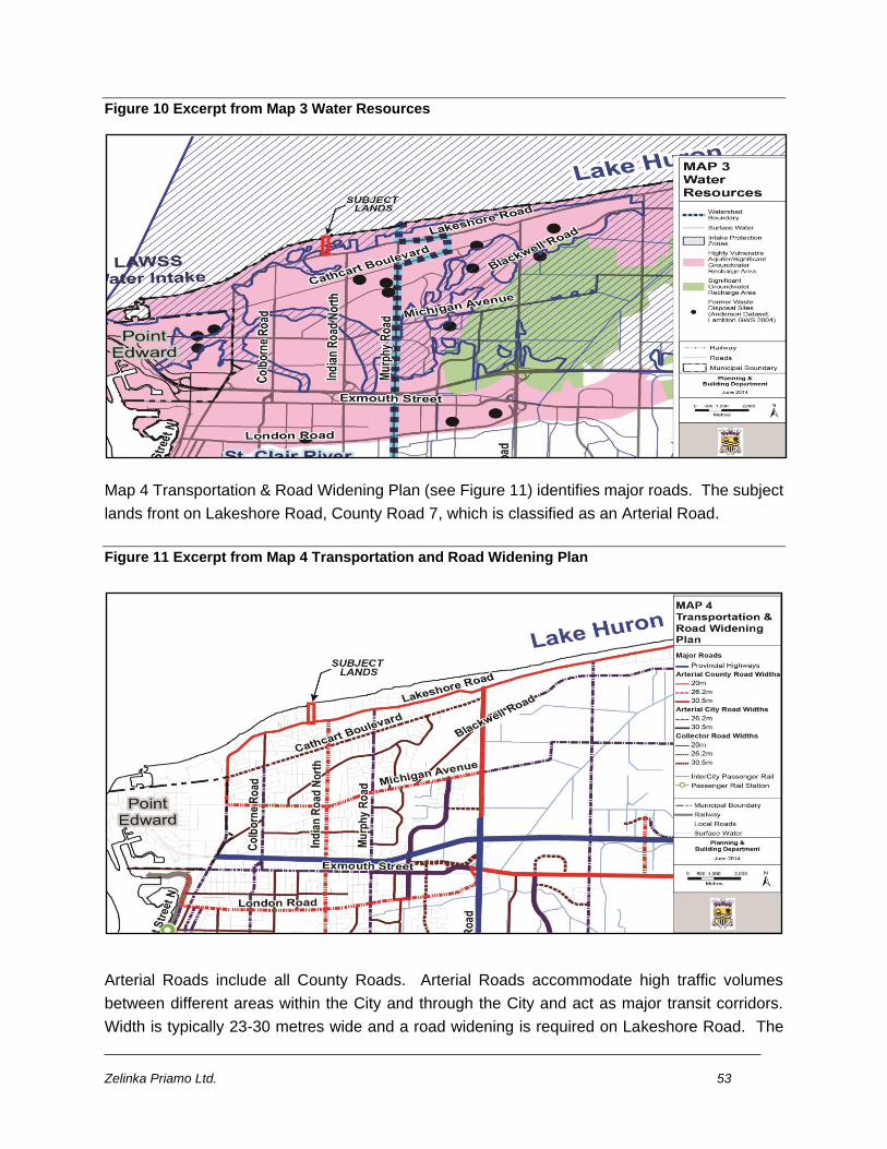
Zelinka Priamo Ltd. 53
Figure 10 Excerpt from Map 3 Water Resources
Map 4 Transportation & Road Widening Plan (see Figure 11) identifies major roads. The subject
lands front on Lakeshore Road, County Road 7, which is classified as an Arterial Road.
Figure 11 Excerpt from Map 4 Transportation and Road Widening Plan
Arterial Roads include all County Roads. Arterial Roads accommodate high traffic volumes
between different areas within the City and through the City and act as major transit corridors.
Width is typically 23-30 metres wide and a road widening is required on Lakeshore Road. The
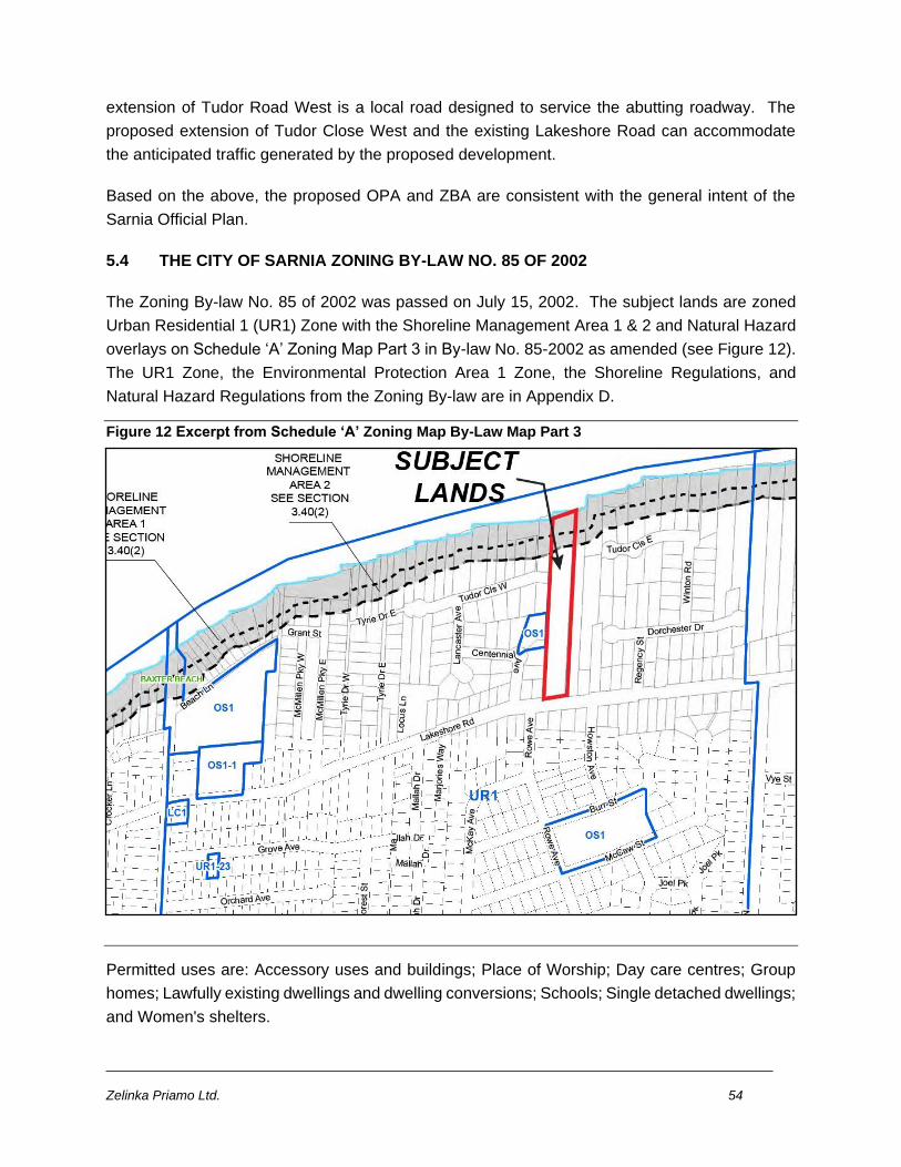
Zelinka Priamo Ltd. 54
extension of Tudor Road West is a local road designed to service the abutting roadway. The
proposed extension of Tudor Close West and the existing Lakeshore Road can accommodate
the anticipated traffic generated by the proposed development.
Based on the above, the proposed OPA and ZBA are consistent with the general intent of the
Sarnia Official Plan.
5.4 THE CITY OF SARNIA ZONING BY-LAW NO. 85 OF 2002
The Zoning By-law No. 85 of 2002 was passed on July 15, 2002. The subject lands are zoned
Urban Residential 1 (UR1) Zone with the Shoreline Management Area 1 & 2 and Natural Hazard
overlays on Schedule ‘A’ Zoning Map Part 3 in By-law No. 85-2002 as amended (see Figure 12).
The UR1 Zone, the Environmental Protection Area 1 Zone, the Shoreline Regulations, and
Natural Hazard Regulations from the Zoning By-law are in Appendix D.
Figure 12 Excerpt from Schedule ‘A’ Zoning Map By-Law Map Part 3
Permitted uses are: Accessory uses and buildings; Place of Worship; Day care centres; Group
homes; Lawfully existing dwellings and dwelling conversions; Schools; Single detached dwellings;
and Women's shelters.
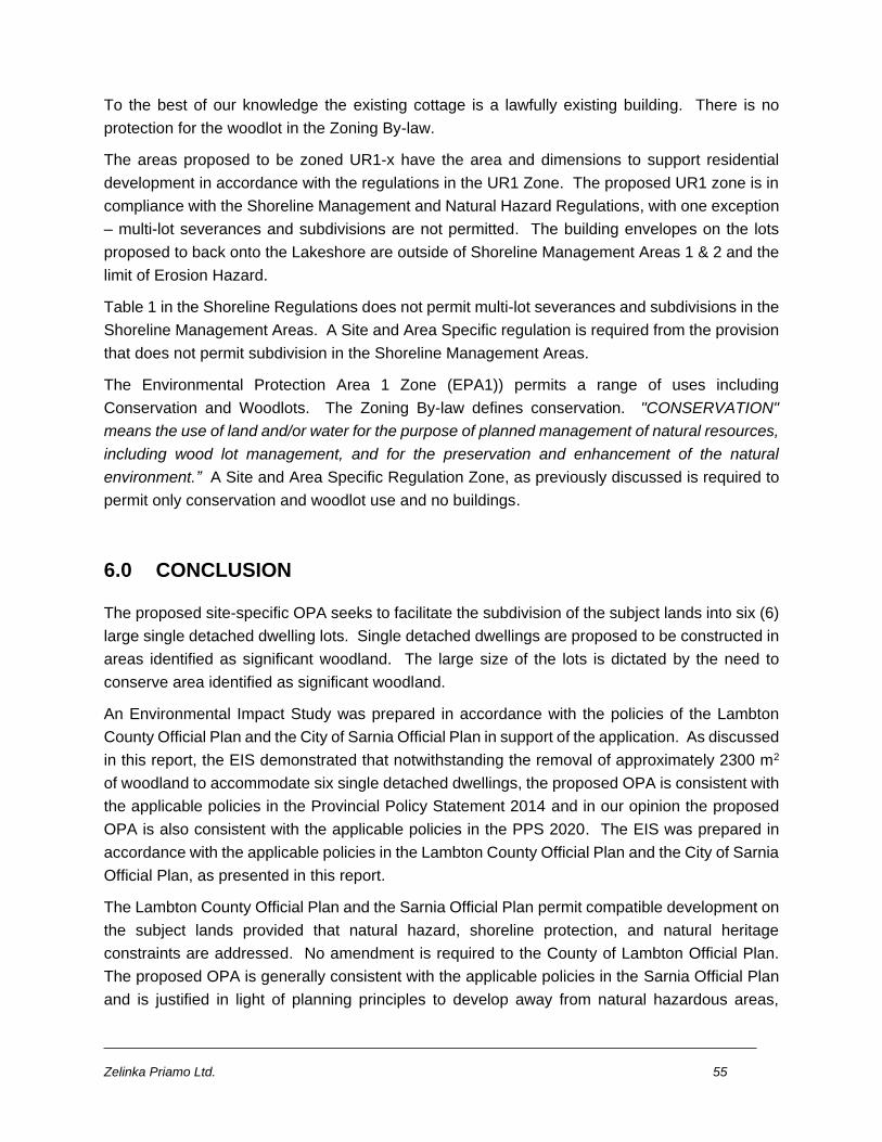
Zelinka Priamo Ltd. 55
To the best of our knowledge the existing cottage is a lawfully existing building. There is no
protection for the woodlot in the Zoning By-law.
The areas proposed to be zoned UR1-x have the area and dimensions to support residential
development in accordance with the regulations in the UR1 Zone. The proposed UR1 zone is in
compliance with the Shoreline Management and Natural Hazard Regulations, with one exception
– multi-lot severances and subdivisions are not permitted. The building envelopes on the lots
proposed to back onto the Lakeshore are outside of Shoreline Management Areas 1 & 2 and the
limit of Erosion Hazard.
Table 1 in the Shoreline Regulations does not permit multi-lot severances and subdivisions in the
Shoreline Management Areas. A Site and Area Specific regulation is required from the provision
that does not permit subdivision in the Shoreline Management Areas.
The Environmental Protection Area 1 Zone (EPA1)) permits a range of uses including
Conservation and Woodlots. The Zoning By-law defines conservation. "CONSERVATION"
means the use of land and/or water for the purpose of planned management of natural resources,
including wood lot management, and for the preservation and enhancement of the natural
environment.” A Site and Area Specific Regulation Zone, as previously discussed is required to
permit only conservation and woodlot use and no buildings.
6.0 CONCLUSION
The proposed site-specific OPA seeks to facilitate the subdivision of the subject lands into six (6)
large single detached dwelling lots. Single detached dwellings are proposed to be constructed in
areas identified as significant woodland. The large size of the lots is dictated by the need to
conserve area identified as significant woodland.
An Environmental Impact Study was prepared in accordance with the policies of the Lambton
County Official Plan and the City of Sarnia Official Plan in support of the application. As discussed
in this report, the EIS demonstrated that notwithstanding the removal of approximately 2300 m2
of woodland to accommodate six single detached dwellings, the proposed OPA is consistent with
the applicable policies in the Provincial Policy Statement 2014 and in our opinion the proposed
OPA is also consistent with the applicable policies in the PPS 2020. The EIS was prepared in
accordance with the applicable policies in the Lambton County Official Plan and the City of Sarnia
Official Plan, as presented in this report.
The Lambton County Official Plan and the Sarnia Official Plan permit compatible development on
the subject lands provided that natural hazard, shoreline protection, and natural heritage
constraints are addressed. No amendment is required to the County of Lambton Official Plan.
The proposed OPA is generally consistent with the applicable policies in the Sarnia Official Plan
and is justified in light of planning principles to develop away from natural hazardous areas,
Zelinka Priamo Ltd. 56
conservation of natural heritage resources, compatible development and the provision of an
adequate supply of housing.
The proposed Site and Area Specific Regulation Zones permit conservation and woodland and
residential uses. Currently there is no protection for the woodland in the Zoning By-law. The
proposed uses and regulations separate the conservation and woodland area use from the
proposed single detached dwelling use. As detailed throughout this Planning Report, the
proposed ZBA is consistent with the PPS and conforms to the Lambton County Official Pan and
conforms with the applicable policies in the Sarnia Official Plan.
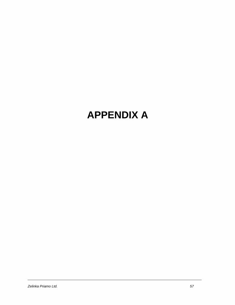
Zelinka Priamo Ltd. 57
APPENDIX A
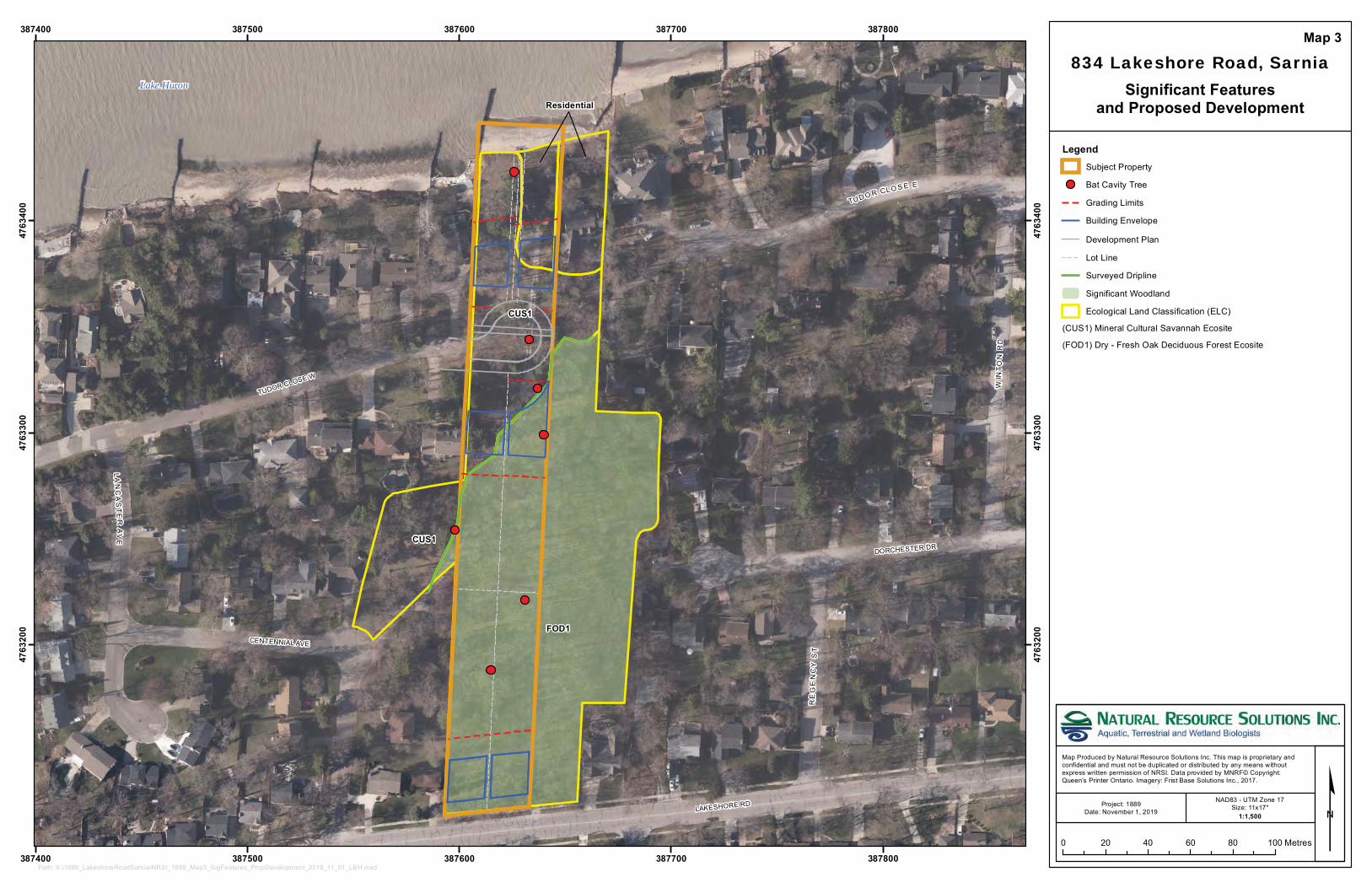
CUS1
Lake Huron
CUS1
FOD1
Residential
DORCHESTER DR
TUDOR CLOSE W
LAN
CA
STE
RA
VE
RE
GE
NC
YS
TLAKESHORE RD
WIN
T ON
RD
TUD O R CL O S E E
CENTENNIAL AVE
387400
387400
387500
387500
387600
387600
387700
387700
387800
387800
4763
200
4763
200
4763
300
4763
300
4763
400
4763
400
834 Lakeshore Road, Sarnia
LegendSubject Property
Bat Cavity Tree
Grading Limits
Building Envelope
Development Plan
Lot Line
Surveyed Dripline
Significant Woodland
Ecological Land Classification (ELC)
(CUS1) Mineral Cultural Savannah Ecosite
(FOD1) Dry - Fresh Oak Deciduous Forest Ecosite
Significant Featuresand Proposed Development
Map 3
Map Produced by Natural Resource Solutions Inc. This map is proprietary and confidential and must not be duplicated or distributed by any means withoutexpress written permission of NRSI. Data provided by MNRF© Copyright: Queen’s Printer Ontario. Imagery: Frist Base Solutions Inc., 2017.
¢0 20 40 60 80 100 Metres
Path: X:\1889_LakeshoreRoadSarnia\NRSI_1889_Map3_SigFeatures_PropDevelopment_2019_11_01_LEH.mxd
Project: 1889Date: November 1, 2019
NAD83 - UTM Zone 17Size: 11x17"
1:1,500
IB
IB
SIB
SIB
IB
RIB BENT
SIB
IB
SIB
IB
SIBRIB
RIB
SIB
STM MH
SAN MH
SAN MH
STM MH
STM MH
SAN MH
250∅
250∅
250∅
250∅
250∅
250∅
250∅250∅250∅
250∅
250∅
300∅
500∅
500∅
500∅
50∅
650∅
500∅
450∅
500∅
400∅
750∅
350∅
400∅
450∅
700∅
700∅
400∅
300∅
300∅
350∅
350∅
300∅
300∅
300∅
400∅
550∅
450∅
450∅
500∅
550∅ 500∅
500∅
550∅
700∅
450∅
350∅
700∅
650∅
650∅
200∅
700∅
200∅
50∅
800∅
1100∅
650∅
350∅
450∅
450∅
650∅
150∅
250∅
250∅
750∅
50∅
150∅
150∅
500∅
250∅
350∅
700∅
250∅
200∅
1100∅
500∅
800∅
550∅
200∅350∅
50∅
400∅
600∅
250∅
400∅
75∅
200∅
600∅
500∅
500∅
400∅
350∅
300∅
500∅
650∅
200∅
350∅
650∅
700∅
300∅
350∅
450∅
150∅
300∅
450∅
350∅
CB
CB
CB
CB
150∅X6
550 STUMP
HYDRO
BOX
LP
TOP
OF
SLO
PETO
E O
F SL
OPE
H
H
(BM
)H
H
EXIST CONCDRIVE
EXIST CONC
DRIVE
EXIST CONC
DRIVE
EXIST BRICK
DRIVE
EXIST CONC
FOUNDATION
CSW
CSW
EXISTING GRVL DRIVE
EXISTING GRVL DRIVE
EXISTING GRVL DRIVE
EXISTING GRVL DRIVE
EXISTING
BUILDIN
G
EXISTING
BUILING
EXISTING DECK
EXISTING
DECK
EXISTING
DECK
EXISTING
BUILING
EXISTING
BUILING
EXISTING
BUILING
EXISTINGBUILING
EXISTING
BUILING
EXIST 200 DIA
ASBESTOS CONC SAN
EXIST 300 DIA
CONC STM
INV 178.857
INV 178.847
INV 178.316
INV 178.326
INV 178.955
INV 178.437
INV 178.437
150 STM
150∅
150 STM150
∅
EXIST 300 DIA
CONC STM
EXIST 200 DIA
ASBESTOS CONC SAN
INV 178.963
EXIST 200 DIA ASBESTOS CONC SAN CLASS 3300
INV 177.379
INV 177.399
INV 6.15
INV 6.15
STM MH
INV 177.250
INV 177.332
EXISTING 600 DIA REINF CONC STM CLASS 3
W
W
EXISTING 600 DIA REINF CONC STM CLASS 3
W
WW
WW
WW
W
W
W
W
W
W
WEXIST 150 DIA WATERMAIN (APPROX LOCATION)
SIB
SIB
EXISTING EDGE OF WOODED AREA
EXISTING EDGE OF WOODED AREA
1
2
3
4
5
6
80.808m
98.021
98.855m
5.969m
102.283m
103.246m
121.324m
104.002m
107.133m
100.871m
20.076m
20.076m
19.806
19.806
EXIS
TIN
G S
EAW
ALL
LAKESHORE ROAD
R CLOSE WEST
SHORELINE
AREA 2
SHORELINE
AREA 1
[
[[
[
[
[
[
[
[
[
[
[
[
[
[
[
[
[
[
[
[
[
[
[
[
[
[
[
[
[
[
[
[
[[
[
[[
[
[
[[
[
[
[
[
[
[
[
[[
[
[
[
[
[
[
[[
[
[
[
[
[ [
[ [[[
[
[
[
[
[
[
[
[[ [
[
[
[
[
[
[
[[
[
[
[
[
[
[
[
[
[
[
[
[
[
[
[
[
[
[
[
[
[
[
[
[
[
[
[
[
[
[
[[
[
[
[[
[
[
[
[
[
[
[
[
[ [ [
[
[
[
[
[
[ [
[
[
[
[
[[
[
[
[
[[
[
[[
[
[
[
[
[
[
[
[
[[
[ [
[
[
[
[
[
[
[
[
[
[
[
[
[
[
[
[
[
[
[
[[
[
[
[
[
[
[
[
[
[
[
[
[
[
[
[
[
[[
[
[
[
[
[
[[
[
[
[
[
[
[
[
[
[
[
[
[
[
[
[
[[
[
[[
[
[
[
[
[
[
[
[
[
[
[[
[
[
[
[ [
[
[
[
[
[
[
[
[[
[
[
[[
[
[
[
[
[
[[
[
[
[
[
[
[
[
[
[
[
[
[
[[
1
2
3
4
5
678
9
10
11
1213
1415
16
17
18
1920
21
2223
24
2526
27 28
29
30
31
3233
34
35
36
37
3839
40
41
424344
45
46
47
48
49
5051
52
53
54
55
56
57
58 59
6061
62
63
64
65
66
67
68
69
70
7172
7374
757677
78
798081
82
8384
8586
87
88
89
90
91
92 93
9495
96
97
98
99
100101
102
103
104
105
106 107
108109
110111
112
113114
115
116
117118
119 120 121
122
123124
125126
127
128129130
131
132
133
134
135136
137
138
139
140141
142
143
144
145
146
147
148
149
150
151152
153
154
155
156
157
158
159
160161
162
163164
165166
167
168
169
170
171
172
173174 175
176 177178
179
180
181 182
183
184185
186187
188
189
190
191192
193
194195
196197198
199
200 201202
203
204 205
206
207
208209
210211 212
213214
215
216
217
218 219
220
221
222
223
224
225226
227228
229
230
231
232 233
234235
236
237
238
239
240
241
242243
244 245
246
247
248
249 250
251
252253
254
255
256257
258259
260
261262
263 264
265 266
267
268
269
270
271
272273
274 275
276277
278
279
280
281
282
283284285
286
287
288289
290291
292293294
295
296
297
298
299
300
301302
303
304
305
306
307308
309
310311
312313
314 315
316
317
318
319
320
321
322
323324
325
326
327 328
329
330
331
332
333
334335
336337
338339
340341
342343
344
345
346
347
348349
350
351352
353
354
355
356
357
358
359
360 361
362
363
364 365
366
367
368
369
370
371
372
373
374
375
376
377378
379380
381
382
383
384
385
386387 388
389
390
391
392
393
394
395
396
397
398
399
400401
402
403404405
406
407
408
409
410
411
412413
414
415
416
417
418
419
420
421422
423424
425426
427
428
429
430
431
432433
434435
436
437
438
439
440441442443
444
445446
447
448449
450451
452
453454
455
456
457
458
459 460
461462463
464465
466467
468
469470
471
472
473474
475
476
477
478 479
480
481482
483484
485486 487
488
489
DO
RC
HE
STE
RD
R
TUD
OR
CLO
SE
E
TUD
OR
CLO
SE
W
LAK
ESH
OR
E RD
C E N TE N N IA L AV E
Map Produced by Natural Resource Solutions Inc. This map is proprietary and confidentialand must not be duplicated or distributed by any means without express written permissionof NRSI. Data provided by MNRF© Copyright: Queen’s Printer Ontario.
Project: 1889Date: October 2, 2017
NAD83 - UTM Zone 17Size: 24x36"
Path: X:\1889_LakeshoreRoadSarnia\NRSI_1889_Map4a_TIPP_2019_11_08_LEH.mxd
Map 4a
LegendSubject Property
&[§ Inventoried Tree to be Retained (Crown to Scale)
§ Inventoried Tree to be Removed (Crown to Scale)
Proposed Building Envelope
Proposed Development
Proposed Servicing
Existing Conditions
Legal Lot Lines
Grading Limits
Surveyed Dripline
Primary Road
Secondary Road
0 5 10 15 20 25 30
Meters
Tree Inventory and Preservation Plan
1:375
834 Lakeshore Road, Sarnia
´
Zelinka Priamo Ltd. 58
APPENDIX B
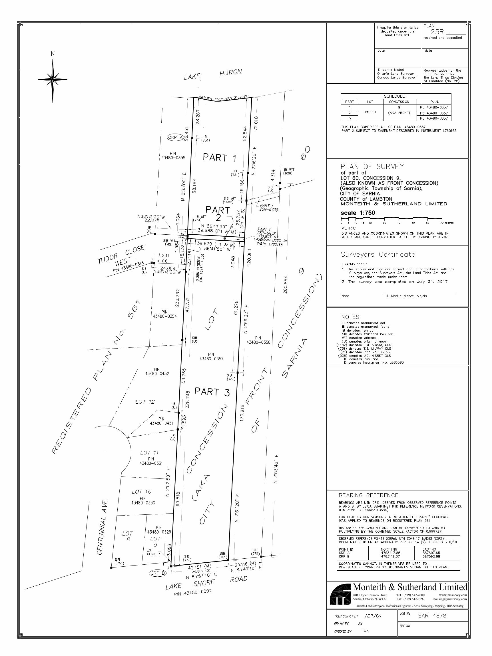
Zelinka Priamo Ltd. 59
APPENDIX C
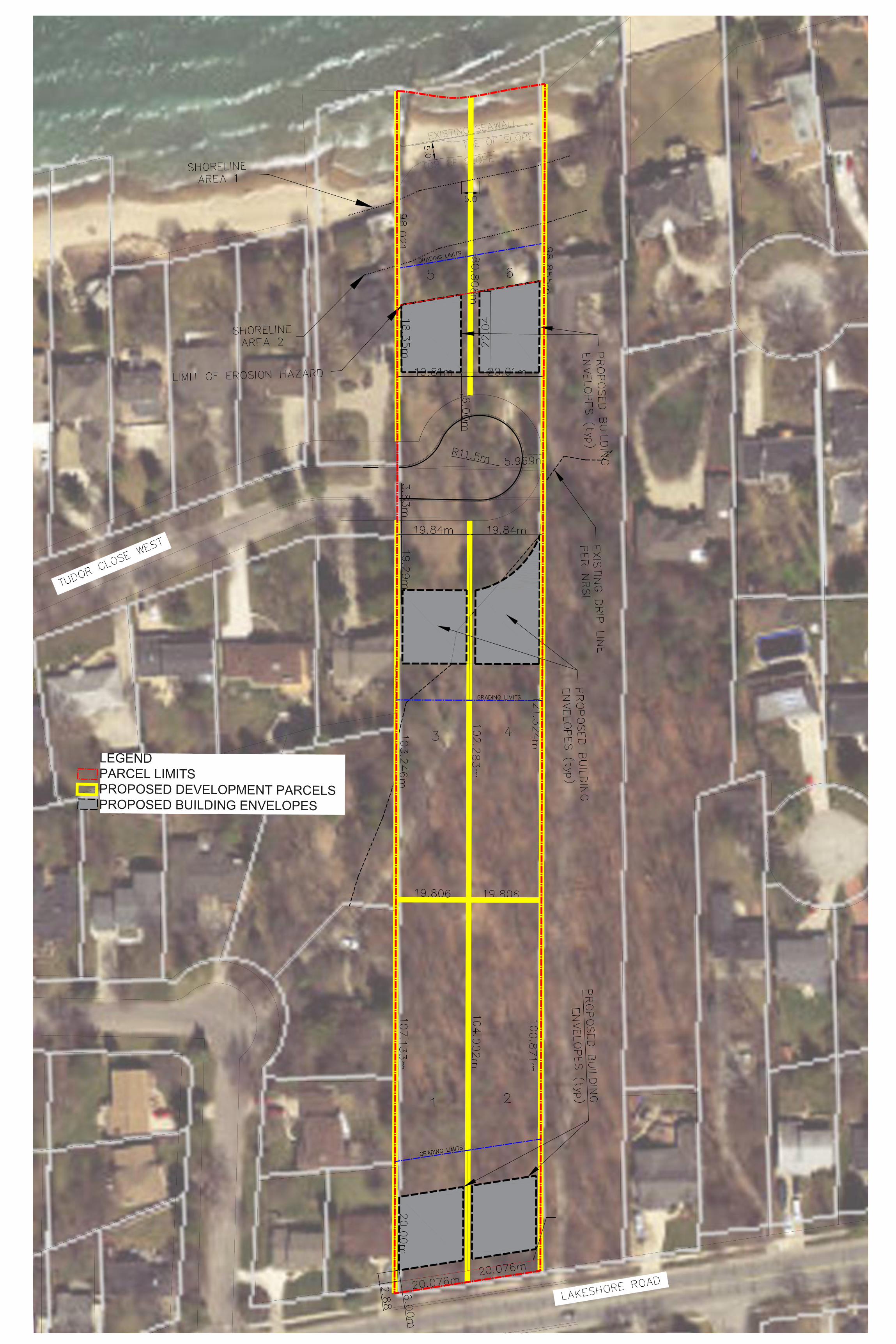
LEGEND
PARCEL LIMITS
PROPOSED DEVELOPMENT PARCELS
PROPOSED BUILDING ENVELOPES
Zelinka Priamo Ltd. 60
APPENDIX D
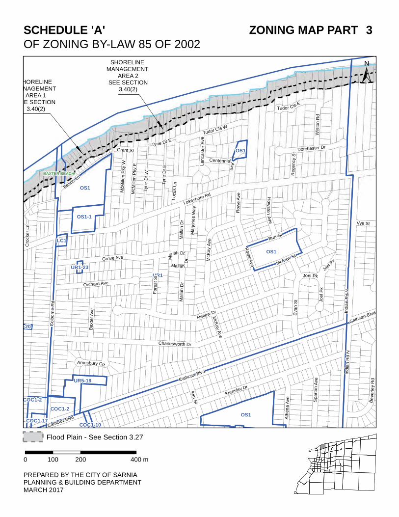
COC1-17
1-20
UR5-19
UR1
COC1-2
LC1
OS1
OS1-1
OS1
OS1
UR1-23
OS1
COC1-10
COC1-2
SHORELINE ANAGEMENT
AREA 1EE SECTION
3.40(2)
SHORELINE MANAGEMENT
AREA 2SEE SECTION
3.40(2)
#
#
Colb
orn
e R
d
Be
ver le
yR
d
Lakeshore Rd
Cathcart Blvd
Cathcart Blvd
Grant St
Tyrie Dr E
Joel
Pk
India
n R
d N
Grove Ave
Charlesworth Dr
McM
illen P
ky E L
ancaste
rA
ve
Dorchester Dr
McCaw St
Tudor Cls W
Cro
cke
r L
n
Vye St
Retlaw DrS
part
an A
ve
Kemsley Dr
Cathcart Blvd
Burr St
Beach L
n
Baxte
r A
ve
Tudor ClsE
Win
ton R
d
Malla
h D
r
Ho
wsto
nA
ve
Fore
st S
tCentennialA
ve
Tyrie
Dr
W
Orchard Ave
Mallah Dr
Mallah
Dr
India
n R
d N
Eva
n S
t Joel P
k
Joel Pk
Kim
St
McK
ay
Ave
McK
ay A
ve
Row
e A
ve
Row
e A
ve
Locu
s L
n
Regency S
t
Marjorie
s W
ay
Malla
h D
r
Ath
en
a A
ve
Amesbury Crt
McM
illen P
ky W
Tyrie
Dr
E
BAXTER BEACH
SCHEDULE 'A' ZONING MAP PART 3
OF ZONING BY-LAW 85 OF 2002
PREPARED BY THE CITY OF SARNIAPLANNING & BUILDING DEPARTMENTMARCH 2017
±
0 200 400100 m
Flood Plain - See Section 3.27
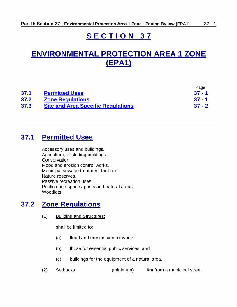
Part II: Section 37 - Environmental Protection Area 1 Zone - Zoning By-law (EPA1)
37 - 1
S E C T I O N 3 7
ENVIRONMENTAL PROTECTION AREA 1 ZONE (EPA1)
Page
37.1 Permitted Uses 37 - 1
37.2 Zone Regulations 37 - 1
37.3 Site and Area Specific Regulations 37 - 2
37.1 Permitted Uses
Accessory uses and buildings. Agriculture, excluding buildings. Conservation. Flood and erosion control works. Municipal sewage treatment facilities. Nature reserves. Passive recreation uses. Public open space / parks and natural areas. Woodlots.
37.2 Zone Regulations
(1) Building and Structures:
shall be limited to:
(a) flood and erosion control works; (b) those for essential public services; and (c) buildings for the equipment of a natural area.
(2) Setbacks: (minimum) 6m from a municipal street
37 - 2 Part II: Section 37 - Environmental Protection Area 1 Zone - Zoning By-law (EPA1)
37.3 Site and Area Regulations
The following site and area specific zones shall be subject to the preceding
permitted uses and zone regulations except where those permitted uses and
regulations are varied by the provisions of these site and area specific zones.
37.3.1 EPA1-1 (See Zoning Map Parts 37, 42, 53, 56, 73, 74, 80 and 81)
37.3.1.1 Permitted Uses
(1) Docking of display ships. (2) Docking of float planes. (3) Industrial docks. (4) Marinas. (5) Recreation. (6) Tour boat docking. (7) Transient docking.
37.3.1.2 Site Zone Regulations
(1) Lot Area: no minimum (2) Lot Frontage: no minimum (3) Front Yard Depth: no minimum
(4) Side Yard Widths: (minimum) 3m, measured from the projection of the side lot lines into the St. Clair River
(5) Height: no maximum
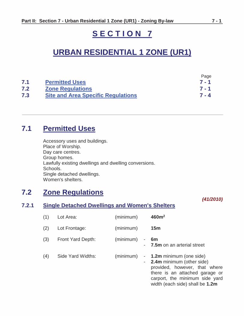
Part II: Section 7 - Urban Residential 1 Zone (UR1) - Zoning By-law
7 - 1
S E C T I O N 7
URBAN RESIDENTIAL 1 ZONE (UR1)
Page
7.1 Permitted Uses 7 - 1
7.2 Zone Regulations 7 - 1
7.3 Site and Area Specific Regulations 7 - 4
7.1 Permitted Uses
Accessory uses and buildings. Place of Worship. Day care centres. Group homes. Lawfully existing dwellings and dwelling conversions. Schools. Single detached dwellings. Women's shelters.
7.2 Zone Regulations (41/2010)
7.2.1 Single Detached Dwellings and Women's Shelters
(1) Lot Area: (minimum) 460m2
(2) Lot Frontage: (minimum) 15m
(3) Front Yard Depth: (minimum) - 6m
- 7.5m on an arterial street
(4) Side Yard Widths: (minimum) - 1.2m minimum (one side)
- 2.4m minimum (other side) provided, however, that where there is an attached garage or carport, the minimum side yard
width (each side) shall be 1.2m
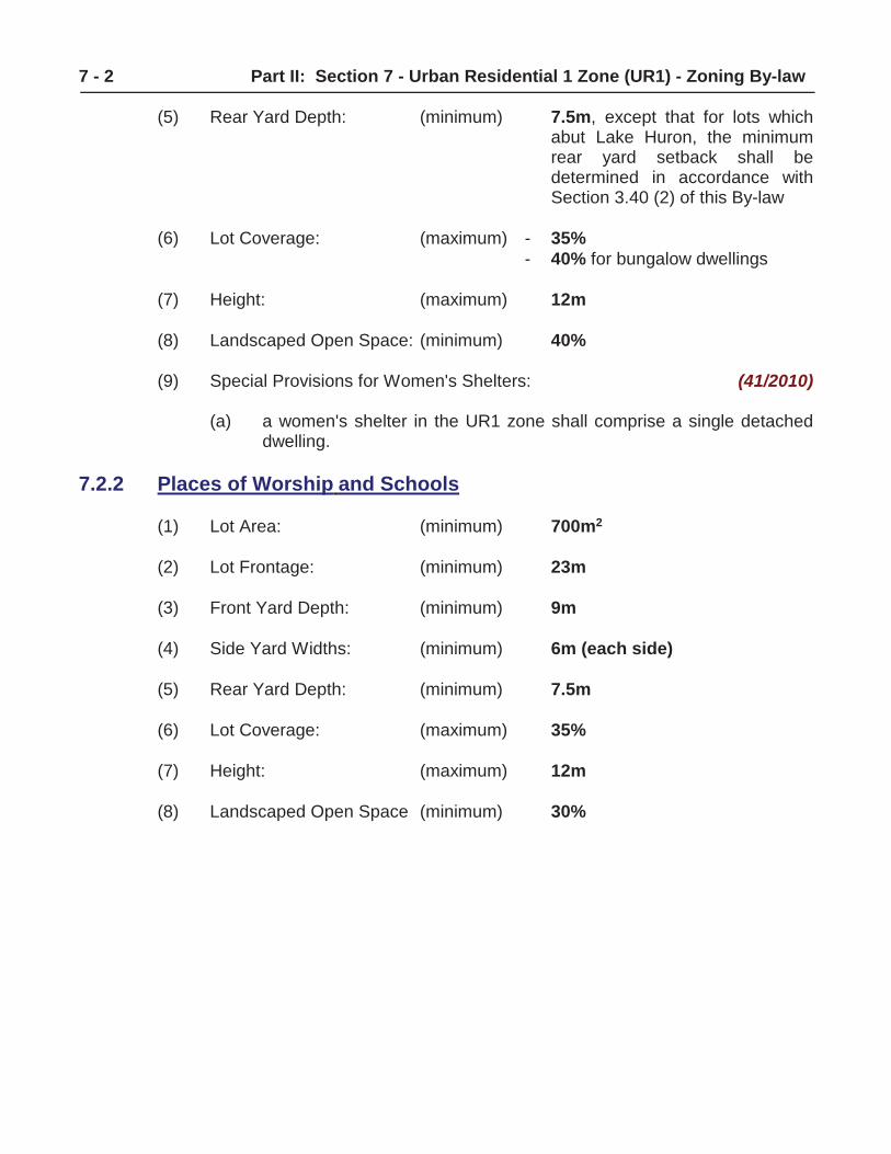
7 - 2 Part II: Section 7 - Urban Residential 1 Zone (UR1) - Zoning By-law
(5) Rear Yard Depth: (minimum) 7.5m, except that for lots which abut Lake Huron, the minimum rear yard setback shall be determined in accordance with Section 3.40 (2) of this By-law
(6) Lot Coverage: (maximum) - 35%
- 40% for bungalow dwellings
(7) Height: (maximum) 12m
(8) Landscaped Open Space: (minimum) 40%
(9) Special Provisions for Women's Shelters: (41/2010)
(a) a women's shelter in the UR1 zone shall comprise a single detached dwelling.
7.2.2 Places of Worship and Schools
(1) Lot Area: (minimum) 700m2
(2) Lot Frontage: (minimum) 23m
(3) Front Yard Depth: (minimum) 9m
(4) Side Yard Widths: (minimum) 6m (each side)
(5) Rear Yard Depth: (minimum) 7.5m
(6) Lot Coverage: (maximum) 35%
(7) Height: (maximum) 12m
(8) Landscaped Open Space (minimum) 30%
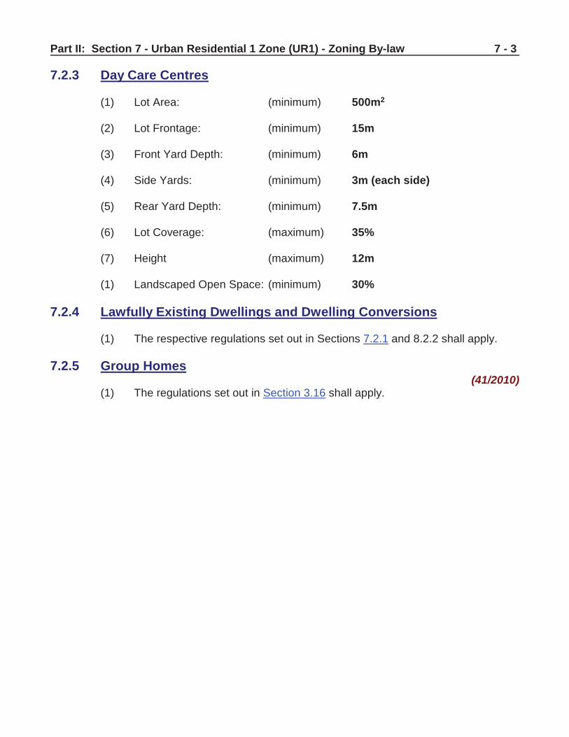
Part II: Section 7 - Urban Residential 1 Zone (UR1) - Zoning By-law
7 - 3
7.2.3 Day Care Centres
(1) Lot Area: (minimum) 500m2
(2) Lot Frontage: (minimum) 15m
(3) Front Yard Depth: (minimum) 6m
(4) Side Yards: (minimum) 3m (each side)
(5) Rear Yard Depth: (minimum) 7.5m
(6) Lot Coverage: (maximum) 35%
(7) Height (maximum) 12m
(1) Landscaped Open Space: (minimum) 30%
7.2.4 Lawfully Existing Dwellings and Dwelling Conversions
(1) The respective regulations set out in Sections 7.2.1 and 8.2.2 shall apply.
7.2.5 Group Homes (41/2010)
(1) The regulations set out in Section 3.16 shall apply.
7 - 4 Part II: Section 7 - Urban Residential 1 Zone (UR1) - Zoning By-law
7.3 Site and Area Specific Regulations
The following site and area specific zones shall be subject to the preceding
permitted uses and zone regulations except where those permitted uses and
regulations are varied by the provisions of these site and area specific zones.
Page Page Page
UR1-1 7 – 4 UR1-19 7 – 14 UR1-37 7 – 21
UR1-2 7 – 5 UR1-20 7 – 14 UR1-38 7 – 22
UR1-3 7 – 5 UR1-21 7 – 15 UR1-39 7 – 23
UR1-4 7 – 6 UR1-22 7 – 15 UR1-40 7 – 23
UR1-5 7 – 6 UR1-23 7 – 16 UR1-41 7 – 24
UR1-6 7 – 7 UR1-24 7 – 16 UR1-42 7 – 24
UR1-7 7 – 7 UR1-25 7 – 16 UR1-43 7 – 24
UR1-8 7 – 8 UR1-26 7 – 17 UR1-44 7 – 25
UR1-9 7 – 8 UR1-27 7 – 17 UR1-45 7 – 26
UR1-10 7 – 9 UR1-28 7 – 18 UR1-46 7 – 27
UR1-11 7 – 10 UR1-29 7 – 19 UR1-47 7 – 27
UR1-12 7 – 10 UR1-30 7 – 19 UR1-48 7 – 28
UR1-13 7 – 10 UR1-31 7 – 20 UR1-49 7 – 28
UR1-14 7 – 11 UR1-32 7 – 20 UR1-50 7 – 29
UR1-15 7 – 12 UR1-33 7 – 20 UR1-51 7 – 29
UR1-16 7 – 13 UR1-34 7 – 20 UR1-52 7 – 29
UR1-17 7 – 13 UR1-35 7 – 21
UR1-18 7 – 14 UR1-36 7 – 21
7.3.1 UR1-1
7.3.1.1 Site Zone Regulations - Single Detached Dwellings
(1) Lot Area: (minimum) 370m2
(2) Lot Frontage: (minimum) 12m (3) All Other Regulations: the regulations set out in Section
7.2.1 shall apply
Part I: Section 3 - General Regulations - Zoning By-law
3 - 23
3.25 Lottery Ticket Sales
Notwithstanding the provisions of Section 2 "Definitions" of this By-law, nothing in this By-law shall apply to prevent the use of any building or part thereof for the purpose of selling lottery tickets where such use is regulated by either the Ontario Lottery Corporation or the Alcohol and Gaming Control Commission.
3.26 Minimum Distance Separation Formulae
(1) Non-Farm Uses
Notwithstanding any other yard or setback provisions of this By-law to the contrary, no non-farm use shall be established, erected or altered unless it complies with the Minimum Distance Separation (MDS) Formula I calculation. (For Information on the MDS formulae refer to Appendices "A").
(2) Farm Uses
Notwithstanding any other yard or setback provisions of this By-law to the contrary, no livestock facility shall be erected or expanded in any “Rural” Zone, unless it complies with the Minimum Distance Separation (MDS) Formula II calculation. (For Information on the MDS formulae refer to Appendices "A").
3.27 Natural Hazard Regulations
(1) General Provisions
Lands within the City characterized by the existence of potential natural hazards such as riverine and shoreline floodplains and erosion have been identified by the St. Clair Region Conservation Authority and are shown in shading as an overlay on the Zoning Map Parts. These areas represent potentially hazardous areas as defined by provincial policy.
Prior to permitting development within the shaded areas, the St. Clair Region Conservation Authority shall be consulted for input and approval. Development may be prohibited or require supporting technical information based on the degree of flooding or erosion hazard. Development includes building, construction, filling and any site alteration.
(2) Perch Creek Natural Hazard Policies
The regulatory flood standard for the Perch Creek watershed is the 100 year flood level.
3 - 24 Part I: Section 3 - General Regulations - Zoning By-law Except where identified by further study, no development other than that used or intended for flood or erosion control purposes, is permitted below the 100 year flood elevation of Perch Creek.
(a) Development Area 1 (See Zoning Map Parts 15 and 24)
A Two Zone floodplain approach divides the floodplain into a more hazardous portion (floodway) and a less hazardous portion (floodfringe). The Two Zone floodplain analysis conducted for the floodplain lands north of Highway 402 by Totten Sims Hubicki Associates, 1993 identified Development Area 1 as floodfringe and established floodproofing requirements and minimum building opening requirements. The elevations are as follows: a minimum building opening floodproofing elevation of 179.3m (CGD) and road/laneway access to be a minimum elevation of no less than 179.1m (CGD).
(b) Development Area 2 (see Zoning Map Parts 49, 50, 63, 64 and 72)
Due to the lack of 1:2000 scale mapping, detailed survey plans and drawings will be required prior to proposing development in close proximity to the 1:100 year floodline limit in Development Area 2. Detailed mapping and delineation of the floodline will be required. The St. Clair Region Conservation Authority’s Regulation applies to any lands subject to flooding under the 1:100 storm event.
All remaining lands outside Development Areas 1 and 2 that may be subject to flooding and erosion within the Perch Creek watershed are subject to the General Provisions section as described in Section 3.27(1).
(3) Cow Creek and St. Clair River Tributaries Natural Hazard Policies
The regulatory flood standard for the Cow Creek and St. Clair River Tributaries watersheds is the 1954 Hurricane Hazel Storm event.
Except where identified by further study, no development other than that used or intended for flood or erosion control purposes, is permitted below the Hurricane Hazel floodline elevation.
(a) North of Lakeshore Road (County Road No. 7) (see Zoning Map Part 10)
A Two Zone floodplain policy exists for the Cow Creek floodplain area north of Lakeshore Road. The Two Zone concept includes a floodway area and floodfringe area (those lands that encroach to a maximum depth of 0.3m into the floodplain). Generally, development is prohibited within the floodway area and development within the floodfringe area must be floodproofed to the Regulatory floodline elevation.
i) Franklin Avenue Area
3 - 46 Part I: Section 3 - General Regulations - Zoning By-law Industrial Zone and Waterfront Zone.
(4) Accessory Buildings
Accessory buildings are permitted in accordance with Section 3.1 of this By-law.
(5) Parking Areas
Parking is permitted in yards in accordance with Section 3.37 of this By-law.
(6) Loading Areas
Loading areas are permitted in yards in accordance with Section 3.22 of this By-law.
(7) Open Storage Areas
Open storage areas are permitted in yards in accordance with Section 3.34 of this By-law.
3.39 Separation from Sewage Lagoons
Notwithstanding any provisions of this By-law to the contrary, no new dwellings shall be constructed within 100.0m of any sewage lagoon.
3.40 Shoreline Regulations
(1) St. Clair River Shoreline Regulations
(a) For the St. Clair shoreline in Sarnia, the Ministry of Natural Resources has determined the 1:100 year flood level to be 178.0m CGD. This 178.0m contour shall be the flood elevation for lands along the St. Clair River. For lots within 50.0m of the St. Clair River, or 50.0m of the St. Clair River 178.0m floodline contour, the required minimum elevation of any openings to new buildings shall be 178.3m. No development should be permitted within the 3.0m setback from the current St. Clair River top of bank.
(b) For lots bordering the St. Clair River that have no shoreline erosion
protection, a new habitable building will be required to have a minimum setback of 15.0m. Additions to existing habitable buildings have less than the required setback from the top of the shoreline bank along the St. Clair River are permitted provided that the addition does not reduce the existing setback.
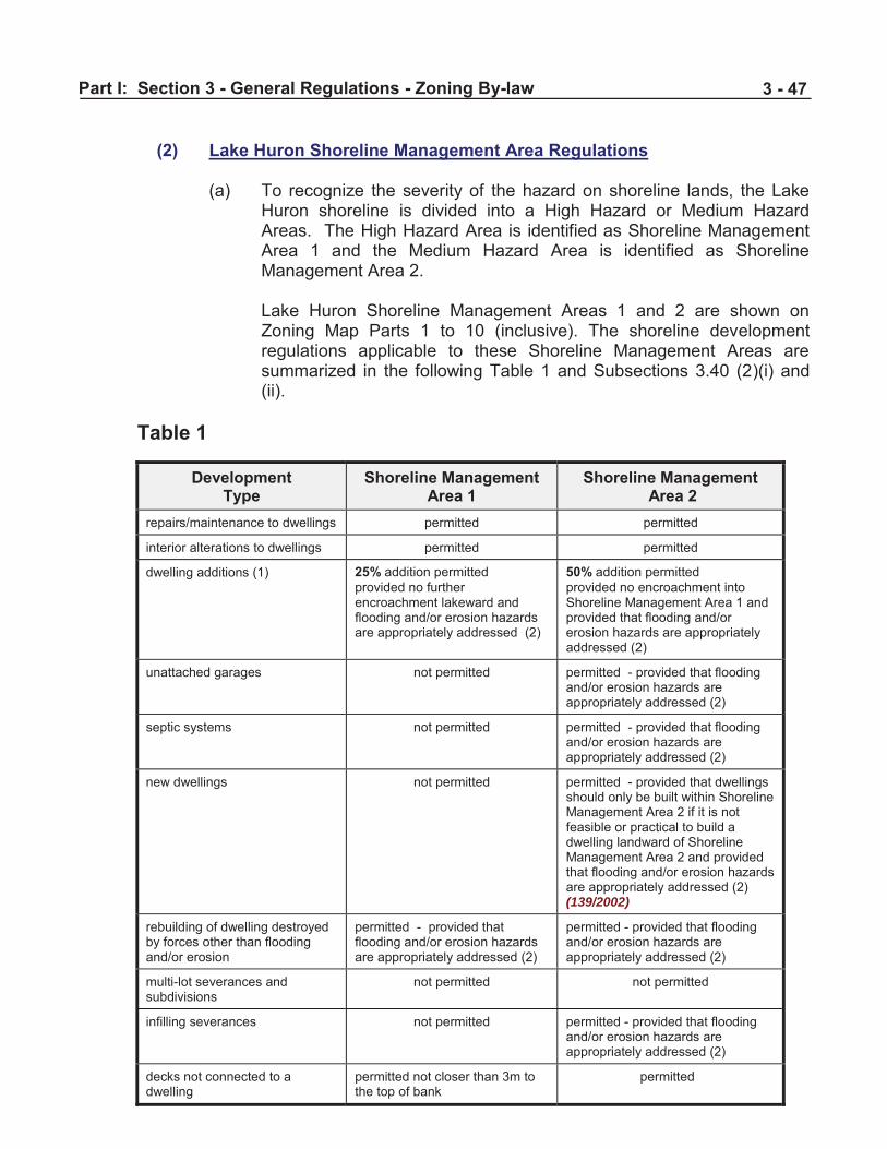
Part I: Section 3 - General Regulations - Zoning By-law
3 - 47
(2) Lake Huron Shoreline Management Area Regulations
(a) To recognize the severity of the hazard on shoreline lands, the Lake
Huron shoreline is divided into a High Hazard or Medium Hazard Areas. The High Hazard Area is identified as Shoreline Management Area 1 and the Medium Hazard Area is identified as Shoreline Management Area 2.
Lake Huron Shoreline Management Areas 1 and 2 are shown on Zoning Map Parts 1 to 10 (inclusive). The shoreline development regulations applicable to these Shoreline Management Areas are summarized in the following Table 1 and Subsections 3.40 (2)(i) and (ii).
Table 1
Development
Type
Shoreline Management
Area 1
Shoreline Management
Area 2 repairs/maintenance to dwellings
permitted
permitted
interior alterations to dwellings
permitted
permitted
dwelling additions (1)
25% addition permitted provided no further encroachment lakeward and flooding and/or erosion hazards are appropriately addressed (2)
50% addition permitted provided no encroachment into Shoreline Management Area 1 and provided that flooding and/or erosion hazards are appropriately addressed (2)
unattached garages
not permitted
permitted - provided that flooding and/or erosion hazards are appropriately addressed (2)
septic systems
not permitted
permitted - provided that flooding and/or erosion hazards are appropriately addressed (2)
new dwellings
not permitted
permitted - provided that dwellings should only be built within Shoreline Management Area 2 if it is not feasible or practical to build a dwelling landward of Shoreline Management Area 2 and provided that flooding and/or erosion hazards are appropriately addressed (2) (139/2002)
rebuilding of dwelling destroyed by forces other than flooding and/or erosion
permitted - provided that flooding and/or erosion hazards are appropriately addressed (2)
permitted - provided that flooding and/or erosion hazards are appropriately addressed (2)
multi-lot severances and subdivisions
not permitted
not permitted
infilling severances
not permitted
permitted - provided that flooding and/or erosion hazards are appropriately addressed (2)
decks not connected to a dwelling
permitted not closer than 3m to the top of bank
permitted
3 - 48 Part I: Section 3 - General Regulations - Zoning By-law
NOTES 1. Additions are expressed as a percentage of the ground floor area of the dwelling existing on the date
of adoption of this By-law.
2. Addressing the flooding and/or erosion hazards in conjunction with the development or redevelopment of a shoreline property can take the form of structural or non-structural measures, or a combination of these measures meant to reduce potential damages. These measures may include (but are not limited to) moveable dwelling designs, dwelling relocation, bluff stabilization measures, protection works, drainage, and beach nourishment. Where protection works are proposed as a means to address the hazards, these works should meet established standards and procedures.
i) Lake Huron Shoreline Management Area 1
Shoreline Management Area 1 is defined as the area of the shoreline between the water’s edge and a line defined by the 100 year flood level to be 178.0m CGD plus a 15.0m allowance for wave uprush and other water related hazards. This is the flood hazard limit as defined by Provincial standards (see Illustration A). Generally, no development, with the exception of those designed, used or intended for flood or erosion control purposes, or as identified in the Shoreline Development Regulations in Table 1 shall be erected in Shoreline Management Area 1.
ii) Lake Huron Shoreline Management Area 2
From Canatara Park to Blackwell Sideroad Shoreline Management Area 2 is defined as the area between Shoreline Area 1 and a line defined by the 100 year flood level plus a 30.0m erosion allowance (see Illustration A). This is the erosion hazard limit as defined by Provincial standards for low bluff and beach areas. The 30.0m erosion allowance recognizes uncertainties associated with natural shoreline processes and the performance of protection works. Dwellings and structures constructed landward of Shoreline Area 2 will not rely on protection works to prevent erosion and damage to the building.
From Blackwell Sideroad to Cow Creek, Shoreline Area 2 is defined by a 30.0m erosion allowance measured from the top of the bluff/bank (see illustration B). This is the erosion hazard limit as defined by Provincial standards for moderately high bluff areas.
Within the Cow Creek to City Limits area, Shoreline Area 2 is defined by the Flood Hazard Limit plus a 30.0m erosion allowance (see Illustration C). In this area, the bluff is lower with a fairly stable beach created by the Cow Creek retaining walls.
Development within Shoreline Management Area 2 shall be carried out in accordance with the regulations in Table 1.
(b) Notwithstanding any provisions of this By-law to the contrary, lands within
75.0m of the shoreline bank of Lake Huron shall also be subject to the following special provisions:
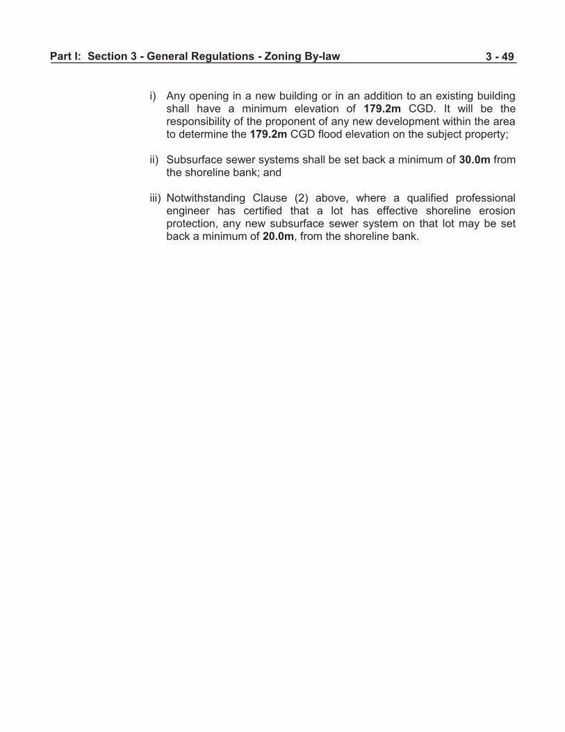
Part I: Section 3 - General Regulations - Zoning By-law
3 - 49
i) Any opening in a new building or in an addition to an existing building
shall have a minimum elevation of 179.2m CGD. It will be the responsibility of the proponent of any new development within the area to determine the 179.2m CGD flood elevation on the subject property;
ii) Subsurface sewer systems shall be set back a minimum of 30.0m from
the shoreline bank; and iii) Notwithstanding Clause (2) above, where a qualified professional
engineer has certified that a lot has effective shoreline erosion protection, any new subsurface sewer system on that lot may be set back a minimum of 20.0m, from the shoreline bank.