Embed Size (px)
Citation preview

Conceptual DevelopmentPlan Recommendations
Planning Memorandum
“The preparation of this document may have been supported, in part, with �nancial assistance from the Federal
Aviation Administration through the Airport Improvement Program. The contents do not necessarily re�ect the
o�cial views or policy of the FAA. Acceptance of these documents by the FAA does not in any way constitute a
commitment on the part of the United States to participate in any development depicted herein nor does it indicate
that the proposed development is environmentally acceptable in accordance with appropriate public law.”
Planning MemorandumJuly 2020
MINNEAPOLIS 7900 International Drive, Suite 980 Bloomington, MN 55425 Phone. 952-941-5619

1
Conceptual Development Plan Recommendations
CONCEPTUAL DEVELOPMENT PLAN
The purpose of this Memorandum is to succinctly describe the recommendations of the development concept for the long-term layout of facilities at Rochester International Airport (RST). These recommendations have been formulated following an extensive alternatives analysis that was conducted over the past year. Over the past month, these recommendations were discussed with the Airport Company Board, the Airport Commission, and the City Council. The outcome being sought from these bodies was agreement that these preliminary recommendations are sound and that they should be carried forward as the basis for finalizing the master plan. With the support of these bodies, these recommendations will be shared in a public information presentation on August 24, 2020. The goal of an Airport Master Plan is to prepare a long-term physical development plan that allows airport management to program for critical capital improvements that accommodate predicted demands in a safe and efficient manner. The following pages provide supporting information on these key takeaways:
The Master Plan is a long-term physical development plan that identifies critical improvements that support RST’s role in providing 24/7/365 operational capability in consideration of anticipated demand.
The most critical component of the planning effort to is identify a program that enables the reconstruction of RST’s two runways, while continuing to provide the necessary operational capability without interruption.
A comprehensive development plan concept has been identified that meets RST’s operational needs during the reconstruction of the runways.
The development plan concept also provides comprehensive recommendations on landside improvements (i.e., passenger terminal improvements, general aviation improvements, access/parking improvements, etc.), which will be required as demands increase over the next two decades.
The next step in the Master Plan is to establish a fiscally reasonable program to phase and fund the identified improvement projects. This process is now underway.
It is anticipated the Master Plan will be substantially complete in November 2020.
The preparation of the Rochester International Airport Master Plan began in February 2018. It was recognized at the beginning of the process that the most significant need to continue the safe and efficient operation of the Airport was the reconstruction of both runways within the next decade, as the pavement on each runway is reaching the end of its useful life. The vital role of the Airport in serving the Mayo Clinic’s patient and medical materials transport needs requires the Airport to be open and operational 24 hours a day, 365 days a year. This means that, during the runway reconstruction work, at least one runway should remain fully operational, including during the reconstruction of the intersection of the two runways. Much of the early work on the Master Plan revolved around working with the FAA to officially recognize the critical role that both the primary runway (Runway 13/31) and the secondary runway (Runway 2/20) play in the operation of the Airport so that adequate funding might be made available to properly improve both runways. Once this official concurrence was received, it allowed the Master Plan team to move forward on putting a plan together that would support 24/7/365 operation of the Airport during the reconstruction of runway pavements.

2
Conceptual Development Plan Recommendations
Due to the complexity of determining the most appropriate solution (in terms of cost, time, resources, safety, and feasibility) during the runway intersection reconstruction, airport staff, our consultant, the FAA, and MnDOT have been working closely together to examine and weigh the alternatives. The existence of a petroleum pipeline located just off the south end of Runway 2/20 and its potential relocation is another significant consideration in formulating an appropriate plan to reconstruct the runways in a manner that supports the Airport’s 24/7/365 operational requirement. The conceptual development plan outlines the proposed development and facility improvements that will not only meet the forecasted demand presented but also mitigate the deficiencies that were identified. The major features of the conceptual development plan include:
Airfield Improvements
Reconstruct secondary Runway 2/20 and extend 1,647 feet
Reconstruct primary Runway 13/31 and reconfigure taxiway connectors
Reconfigure, extend, and reconstruct/rehabilitate Taxiway B and its connectors to provide a full parallel taxiway with a consistent width and runway-taxiway separation
Rehabilitate Taxiway A
Construct paved runway and taxiway shoulders and blast pads
Perform preventive pavement maintenance
Reserve space southwest of Runway 13 for future aeronautical use development
Construct a partial parallel taxiway south of Runway 13/31
Instrument Approach Improvements
Establish Special Authorization Category (CAT) II precision approach to Runway 2
Install approach equipment (MALSR, glide slope antenna, localizer)
Acquire 39.2 acres of property around Runway 2 end
Acquire 29.8 acres of property around Runway 13 end
Complete full installation of CAT II approach to Runway 31 (already in progress)
Airfield Support Facilities Improvements
Upgrade and expand fuel farm
Expand and remodel SRE/ARFF facilities
Acquire new ARFF and SRE equipment
Reserve space northeast of Runway 31 for future cargo/industrial development

3
Conceptual Development Plan Recommendations
Passenger Terminal Improvements
Perform passenger terminal upgrades (short-term)
Expand terminal to the east and west (mid-term)
Separate domestic and international baggage claim functions
Relocate and expand domestic baggage claim to east side of terminal
Expand international baggage claim area and add an international lounge in existing location (west side of the terminal)
Lengthen curbside and change to standard sequence: international, ticketing, baggage claim
Reconfigure concourse and gate areas to serve today’s commercial fleet (ongoing)
Provide additional second-level gates and departure lounges
Improve/add vertical circulation
Move concessions to second level
Consider closing ground-level gates
Improve baggage security screening
Expand commercial terminal apron (long-term)
Parking Improvements
Reconstruct, upgrade, and expand terminal parking lot as demand dictates
Add covered parking and a ground transportation center
Reserve non-aeronautical space for a future park and ride lot
Construct a cell phone/ride share parking lot
Expand employee parking lot
Construct a rental car wash facility
Roadway Improvements
Relocate/construct airport perimeter road
Relocate a portion of 90th Street SE/former Trunk Highway 30 SW around future Runway 2 protection zone
Relocate a portion of 31st Avenue SW
Reconfigure terminal curbside and entrance loop

4
Conceptual Development Plan Recommendations
General Aviation (GA) Area Improvements
Reconfigure hangar area and construct/replace hangars as necessary
Develop and expand north GA area as demand dictates
Rehabilitate and expand GA apron
Rehabilitate GA access road
Expand/remodel/relocate existing GA terminal
Conceptual Development Plan Figures
The Airport’s Conceptual Development Plan (CDP) is depicted in the following figures.
Figure 1 – Conceptual Development Plan Figure 1 depicts the overall development plan for RST over the 20-year planning period, which includes all the improvements listed above. Primary Runway 13/31 will be reconstructed and retain its existing length of 9,034 feet. In addition, a partial parallel taxiway south of Runway 13/31 from Taxiway B to Runway 13 is shown to provide access to a future aeronautical use area. Secondary Runway 2/20 will be reconstructed and extended to the south, which is detailed in Figure 2. Taxiway geometry will be reconfigured to eradicate an FAA-identified hot spot, meet FAA design standards, eliminate direct access from aprons to runways, reduce excessive pavement, and enhance the level of safety for operations at RST. Figure 1 also shows hold bays being constructed adjacent to Runway 13 and Runway 2.
Figure 2 – Runway 2/20 Extension Conceptual Development Plan Figure 2 highlights the most significant project of the overall CDP. This 1,647-foot extension to the south end of secondary Runway 2/20 allows RST to maintain uninterrupted operational capability while primary Runway 13/31 is reconstructed in the late 2020s. This extension provides for 6,500 feet of useable runway length during the reconstruction of the Runway 2/20 and Runway 13/31 intersection, which is the length required for RST’s critical users to maintain operations during this interim condition. Once the intersection is reconstructed and reopened, Runway 2/20 will have a useable length of 8,354 feet, which meets the critical users’ long-term length needs without concessions. Figure 2 also depicts the land acquisition, fence relocation, road relocation, and required safety zones resulting from the runway extension. In addition, this figure shows the location of the existing BP pipeline, which will need to be moved prior to the runway extension. Finally, Figure 2 shows the location of future instrument approach ground-based equipment, including antennas, lighting, and buildings.

5
Conceptual Development Plan Recommendations
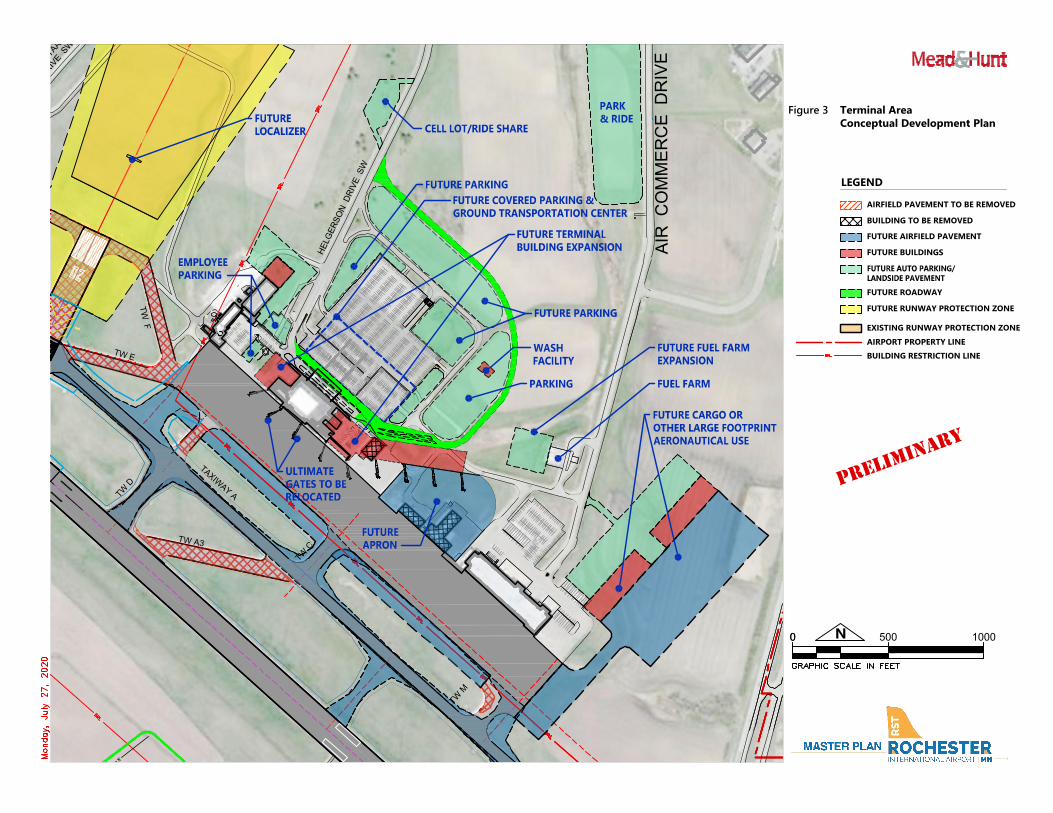
Figure 3 – Terminal Area Conceptual Development Plan Figure 3 highlights the recommended improvements to the terminal area listed above. This plan expands the concourse to support growth for passenger services, baggage claim, checkpoint, concessions, circulation, mechanical spaces, and additional gates, and reconfigures and expands the departure lounges. The concourse expansion is angled back from the apron, adding depth for parking and maneuvering newer aircraft. Figure 3 also depicts the location of expanded and modernized parking areas and roadways, including enhanced curbside access, future parking, a rental car wash facility, and a cell phone lot. This figure shows space reserved for potential transit connectivity, such as a park and ride lot. An expansion to the cargo facility adjacent to the terminal, essentially doubling its existing size, and space reserved for a future fuel facility expansion are also shown on this figure.
Figure 4 – General Aviation Area Conceptual Development Plan Figure 4 highlights the recommended improvements to and location of future expansion of the GA area. One of the primary drivers for this plan is to allow for incremental expansion to support demand as it develops, providing flexibility while minimizing capital expenditures for each hangar project. This comprehensive plan to revitalize the public areas adjacent to the GA apron features removal of old hangars to allow for new front-line hangars and expansions to the FBO facility and apron, with a focus on separating areas for large and small GA aircraft.

T
A
X
I
W
A
Y
B
T
A
X
I
W
A
Y
B
T
W
H
T
W
A
1
T
W
G
T
W
A
9
T
W
A
1
0
T
W
M
C.S.A.H. NO. 16
N
E
W
T
R
U
N
K
H
W
Y
3
0
/
C.S.A.H. NO. 16
31S
T A
VE
NU
E S
W
LC DRIVE SW
LC
D
RIV
E S
W
AIR
C
OM
ME
RC
E D
RIV
E S
W
D
R
I
V
E
S
W
T
R
U
N
K
H
IG
H
W
A
Y
6
3
S
O
U
T
H
T
R
U
N
K
H
IG
H
W
A
Y
6
3
S
O
U
T
H
I
N
T
E
R
S
T
A
T
E
9
0
80TH STREET SE
85TH STREET SE
90TH STREET SE
90th STREET/ FORMER TRUNK HIGHWAY 30 SW
3
1
S
T
A
V
E
N
U
E
S
W
80TH STREET SW
T
W
A
6
T
W
E
T
W
F
T
W
C
T
A
X
I
W
A
Y
A
T
W
A
3
T
W
D
T
W
A
7
T
W
J
T
A
X
I
W
A
Y
A
T
W
A
8
T
W
K
B
R
A
T
A
A
S
T
W
B
4
T
W
B
3
T
W
B
1
T
W
B
2
H
E
L
G
E
R
S
O
N
D
R
I
V
E
S
W
x
x
x
x
x
x
x
G
G
F
O
R
M
E
R
C
.
S
.
A
.
H
.
N
O
.
1
6
Figure 1 Conceptual Development Plan
LEGEND
N
00 2000 4000
AIRFIELD PAVEMENT TO BE REMOVED
EXISTING RUNWAY PROTECTION ZONE
AIRPORT PROPERTY LINE
FUTURE AIRFIELD PAVEMENT
FUTURE RUNWAY PROTECTION ZONE
FUTURE 1,647' RUNWAY
EXTENSION
FUTURE PRECISION APPROACH
RUNWAY PROTECTION ZONE
FUTURE PROPERTY
ACQUISITION
(39.2 ACRES)
FUTURE ROAD RELOCATION
FUTURE PROPERTY ACQUISITION
FUTURE BUILDINGS
FUTURE AUTO PARKING
FUTURE CARGO
DEVELOPMENT AREA
FUTURE GENERAL AVIATION
DEVELOPMENT AREA
FUTURE TERMINAL
BUILDING EXPANSION
AND PARKING
DEVELOPMENT AREA
FUTURE GLIDE SLOPE ANTENNA
FUTURE MALSR
FUTURE GA DEVELOPMENT AREA
FUTURE AERONAUTICAL
USE DEVELOPMENT AREA
FUTURE LANDSIDE
ACCESS ROAD
ROAD CLOSED
FUTURE
LOCALIZER
ROAD RELOCATION
ATCT
FUTURE PROPERTY
ACQUISITION
(29.8 ACRES)
FUTURE
PARK & RIDE
FUTURE ROADWAY
FUTURE FENCELINE
FUTURE FENCELINE
& PERIMETER ROAD
FUTURE FENCELINE
PIPELINE TO BE
RELOCATED
PRELIMI
NARY
RUNWAY 2/20
150' x 7,301' (EXISTING)
150' x 8,354' (FUTURE)
RUNWAY 13/31
150' x 9,034'
FUTURE NON-PRECISION APPROACH
RUNWAY PROTECTION ZONE

T
A
X
I
W
A
Y
B
I
N
T
E
R
S
T
A
T
E
9
0
90th STREET/ FORMER TRUNK HIGHWAY 30 SW
3
1
S
T
A
V
E
N
U
E
S
W
T
W
B
4
x
x
x
x
x
x
x
x
G
G
G
G
G
Figure 2
LEGEND
N
00 1000 2000
AIRFIELD PAVEMENT TO BE REMOVED
EXISTING RUNWAY PROTECTION ZONE
AIRPORT PROPERTY LINE
FUTURE AIRFIELD PAVEMENT
FUTURE RUNWAY PROTECTION ZONE
FUTURE 1,647' RUNWAY
EXTENSION
FUTURE PRECISION APPROACH
RUNWAY PROTECTION ZONE
FUTURE PROPERTY
ACQUISITION
(39.2 ACRES) FUTURE ROAD RELOCATION
FUTURE PROPERTY ACQUISITION
FUTURE BUILDINGS
FUTURE AUTO PARKINGFUTURE GLIDE SLOPE ANTENNA
FUTURE MALSR
FUTURE GA DEVELOPMENT AREA
ROAD CLOSED
ROAD RELOCATION
FUTURE ROADWAY
FUTURE FENCELINE
& PERIMETER ROAD
FUTURE FENCELINE
PIPELINE TO BE
RELOCATED
PRELIMI
NARY
RUNWAY 2/20
150' x 7,301' (EXISTING)
150' x 8,354' (FUTURE)
Runway Extension Conceptual
Development Plan
FUTURE FENCELINE
T
W
M
AIR
C
OM
ME
RC
E D
RIV
E S
W
D
R
I
V
E
S
W
T
W
E
T
W
F
T
W
C
T
A
X
I
W
A
Y
A
T
W
A
3
T
W
D
B
R
A
T
A
A
S
H
E
L
G
E
R
S
O
N
D
R
I
V
E
S
W
x
Figure 3 Terminal Area
Conceptual Development Plan
LEGEND
N
00 500 1000
AIRFIELD PAVEMENT TO BE REMOVED
EXISTING RUNWAY PROTECTION ZONE
AIRPORT PROPERTY LINE
FUTURE AIRFIELD PAVEMENT
FUTURE BUILDINGS
FUTURE CARGO OR
OTHER LARGE FOOTPRINT
AERONAUTICAL USE
FUTURE TERMINAL
BUILDING EXPANSION
FUTURE
LOCALIZER
FUTURE PARKING
FUTURE PARKING
EMPLOYEE
PARKING
PARKING
WASH
FACILITY
CELL LOT/RIDE SHARE
FUTURE
APRON
ULTIMATE
GATES TO BE
RELOCATED
BUILDING TO BE REMOVED
FUTURE ROADWAY
BUILDING RESTRICTION LINE
FUEL FARM
PARK
& RIDE
FUTURE FUEL FARM
EXPANSION
FUTURE COVERED PARKING &
GROUND TRANSPORTATION CENTER
FUTURE AUTO PARKING/
LANDSIDE PAVEMENT
FUTURE RUNWAY PROTECTION ZONE
PRELIMI
NARY

T
W
H
T
W
G
N
E
W
T
R
U
N
K
H
W
Y
3
0
/
D
R
I
V
E
S
W
T
W
A
6
T
W
F
T
W
A
7
T
W
J
T
A
X
I
W
A
Y
A
T
W
A
8
T
W
K
B
R
A
T
A
A
S
x
F
O
R
M
E
R
C
.
S
.
A
.
H
.
N
O
.
1
6
Figure 4 General Aviation Area
LEGEND
N
00 500 1000
LONG-TERM GENERAL AVIATION
DEVELOPMENT AREA
FUTURE
LOCALIZER
PHASE ONE
TAXIWAY ACCESS
TO SMALL GA
HANGAR
DEVELOPMENT
AIRPORT PROPERTY LINE
BUILDING RESTRICTION LINE
115'
210'
EXISTING
GA TERMINAL
POTENTIAL FUTURE
FUEL FARM LOCATION
LONG-TERM GENERAL AVIATION
DEVELOPMENT AREA
Conceptual Development Plan
GENERAL AVIATION
CLUBHOUSE
AIRFIELD PAVEMENT TO BE REMOVED
EXISTING RUNWAY PROTECTION ZONE
FUTURE AIRFIELD PAVEMENT
FUTURE RUNWAY PROTECTION ZONE
FUTURE BUILDINGS
FUTURE GA DEVELOPMENT AREA
FUTURE ROADWAY
PRELIMI
NARY
FUTURE
RUNWAY
PROTECTION
ZONE