Embed Size (px)
Citation preview
Planning Proposal Amendment to ELEP 2012 Land Zoning Map, Height of Buildings Map and Lot Size Map for land at
Broulee
ELEP 2012 Amendment No. 11
2
Contents
INTRODUCTION……………………………………………………………………………………………………. 3
PART 1: OBJECTIVES or INTENDED OUTCOMES………………………………………………..….. 5
PART 2: EXPLANATION of PROVISIONS……………………………………………………………….... 6
PART 3: JUSTIFICATION for PROPOSAL………………..……………………………………………….. 6
Section A- NEED for the PLANNING PROPSAL…………………………………….…….. 6
Section B- RELATIONSHIP to STARTEGIC PLANNING FRAMEWORK…………... 8
Section C- ENVIRONMENTAL, SOCIAL and ECONOMIC IMPACT………………… 12
Section D- STATE and COMMONWEALTH INTERESTS……………………………….. 14
PART 4: MAPPING………………………………………………………………………………………………… 16
PART 5: COMMUNITY CONSULTATION…………………………………………………………….…… 21
PART 6: PROJECT TIMELINE……………………………………………………………………………..…… 21
ATTACHMENT 1: PROPOSED AMENDMENTS TO RESIDENTIAL ZONES DCP……………. 22
ATTACHMENT 2A: MASTER PLAN – ZONING CONCEPT…………………………………………… 26
ATTACHMENT 2B: MASTER PLAN – ROAD/ PEDESTRAIN NETWORK……………….……… 27
ATTACHMENT 2C: MASTER PLAN – DRAINAGE CONCEPT PLAN………………….……..…… 28
ATTACHMENT 2D: MASTER PLAN – SEWER CATCHMENT CONCEPT PLAN..…………… 29
3
INTRODUCTION
The planning proposal explains the intended effect of, and justification for the proposed
amendment to Eurobodalla Local Environmental Plan (ELEP 2012) to rezone land at Broulee
and to make consequent amendments to the height of buildings and minimum lot size
standards for the land.
The subject land is generally bounded by George Bass Drive, Train and Broulee Streets and
existing residential development at Broulee and consists of the following lots:
Lot 1 DP 825610, George Bass Drive, Broulee
Lot 9 DP 1068530, Adams Way, Broulee
Lot 3 DP 633700, Broulee Road, Broulee
Lot 20 DP 1174639, Train Street, Broulee
Lot 13 DP 1136019, Heath Street, Broulee
Lot 63 DP 1202934, Heath Street, Broulee
Lot 50 DP 837279, Broulee Road, Broulee
Lot 89 DP 1093710, 75 Clarke Street, Broulee
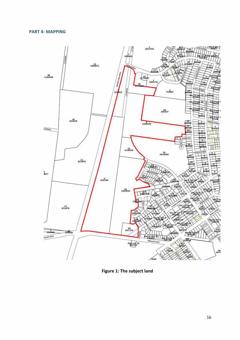
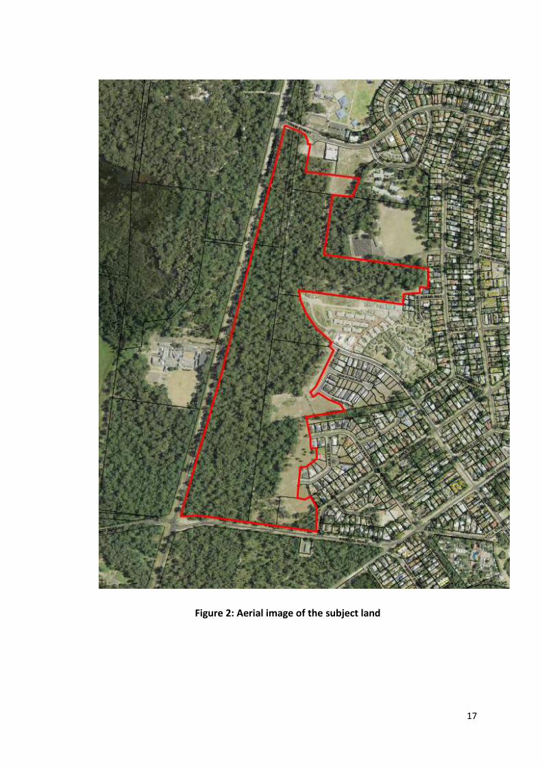
The land is depicted in Part 4 – Figures 1 and 2.
The subject land is currently undeveloped and is subject to a Biocertification Agreement
pursuant to the Threatened Species Conservation Act 1995.
The proposal has been prepared in accordance with Section 55 of the Environmental
Planning and Assessment Act 1979 and the relevant Department of Planning and
Environment Guidelines, including A Guide to Preparing Local Environmental Plans and A
Guide to Preparing Planning Proposals.
Council is seeking to progress this planning proposal through the gateway determination
process as an amendment to ELEP 2012.
The proposal is supported by draft amendments to Eurobodalla’s Residential Zones
Development Control Plan, including a concept master plan for development of the subject
land.
Background
This planning proposal was first submitted to the Department of Planning and Environment
for a Gateway Determination on 1 July 2015. In response to some concerns raised by
members of the community, the Department sought additional information from Council.
Following consideration of that additional information, a Gateway Determination was issued
by the Department on 2 October 2015.
The Gateway Determination required the planning proposal to be resubmitted for the
following reasons:
4
1. Insufficient strategic justification to support the location and scale of the proposed
R3 Medium Density residential zone.
2. Preparation of a masterplan to address a number of matters including integration of
the proposed higher density residential area into the scale and character of Broulee,
urban design, management of conservation areas, traffic, pedestrian/cycle access
and stormwater management.
3. Consultation with the Office of Environment and Heritage and NSW Rural Fire
Service during preparation of the masterplan.
Strategic Justification for Location and Scale of Proposed R3 Zone
In the development of a masterplan for the development area, the following changes have
been made to the planning proposal:
the extent of R3 medium density zoning has been reduced; and
the proposed reduction in minimum lot size to 450m² was deleted.
These two changes significantly address a number of the concerns raised by some members
of the community. As a result, point 1 above is considered to be addressed, as all of the
proposed medium density zone is now within 800m of commercial land, a standard rule of
thumb for the location of higher density housing.
Preparation of a Masterplan
The master plan developed for the land provides a road and lot layout demonstrating how
the development will integrate with the scale and character of Broulee and addressing
strategic traffic, pedestrian and cycle access throughout the development area. The master
plan also addresses the servicing of the land, including for stormwater management, and
provides for additional local open space in strategic locations to service the whole
development area. Issues of urban design have been further addressed in this planning
proposal.
In relation to the scale and character of Broulee, the planning proposal will have minimal
impacts. While the proposed increase in R3 zoned land results in an increased development
yield for the subject land, the extent of that increase is minimal.
As the subject land is currently mostly zoned R2 Low Density Residential, with a small area
of R3 Medium Density Residential, it can be subdivided (with consent) for a range of housing
developments. Assuming a density of 10 dwellings per hectare for the R2 part and 20
dwellings per hectare for the R3 part, a total of 350 dwellings could be developed without
any change to the mix of existing residential zoning. The current residential area of Broulee
(including both low and medium density housing) has an average density of 11 dwellings per
hectare.
The planning proposal seeks to increase the amount of R3 zone compared to the R2 zone.
This change increases the area of R3 zone from approximately 2ha to 9ha. Using the same
density assumptions as above, a total of 425 dwellings could be developed in the area.
5
Therefore, the planning proposal results in an increase of 75 dwellings over the current
zoning potential.
In terms of population, the current zoning and dwelling potential would result in an increase
to the Broulee population from 1432 (2011 census) to 2032, an increase of 600 people. The
planning proposal potentially increases the population to 2128, an additional increase of 96
people.
The following tables outline the calculations for the above dwelling and population
numbers:
Dwelling and population calculations - without any change to current zoning
Area (ha)
Density (dw/ha)
Dwellings plus
Vacant Lots
Occupancy Rate (%)
Persons per
household Population
Existing Broulee 110 11 1219 50.5 2.14 1317
Existing vacant R2 31 10 310 95 2.2 648
Existing vacant R3 2 20 40 83 2 66
Total 143 1569 2032
Dwelling and population calculations – based on planning proposal
Area (ha)
Density (dw/ha)
Dwellings plus
Vacant Lots
Occupancy Rate (%)
Persons per
household Population
Existing Broulee 110 11 1219 50.5 2.14 1317
R2 area 24 10 245 95 2.2 512
R3 area 9 20 180 83 2 299
Total 143 1644 2128
Consultation with OEH and RFS
Consultation on the master plan with the Office of Environment and Heritage and the Rural
Fires Service has been commenced and any comments from those agencies will be
considered throughout the planning proposal process.
PART 1: OBJECTIVES or INTENDED OUTCOMES
The objective of this planning proposal is to protect an identified conservation area in
accordance with the Biocertification Agreement for the land and to facilitate a greater mix
of housing opportunities in the development area.
6
PART 2: EXPLANATION of PROVISIONS
The objective of the Planning Proposal will be achieved by a site specific amendment of the
Eurobodalla LEP 2012:
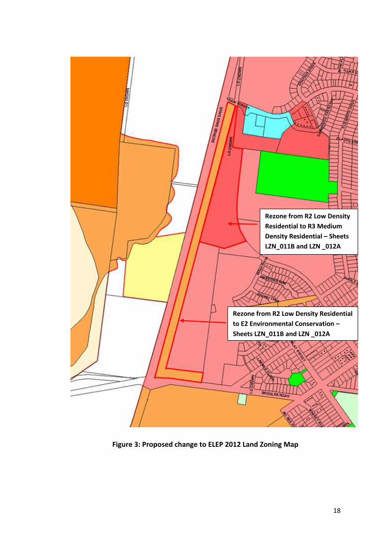
to rezone part of the land from the R2 Low Density Residential zone to the E2
Environmental Conservation zone through an amendment to the ELEP 2012 Land
Zoning Map Sheets LZN_011B and LZN_012A;
to rezone part of the land from the R2 Low Density Residential zone to the R3
Medium Density Residential zone through an amendment to the ELEP 2012 Land
Zoning Map Sheets LZN_011B and LZN_012A;
to add a maximum building height standard of 8.5m to part of the land proposed to
be zoned R3 Medium Density Residential through an amendment to the ELEP 2012
Height of Buildings Map Sheets LZN_011B and LZN_012A;
to remove the maximum building height standard for that part of the land proposed
to be zoned E2 Environmental Conservation through an amendment to the ELEP
2012 Height of Buildings Map Sheets LZN_011B and LZN_012A; and
to remove the minimum lot size standard for that part of the land proposed to be
zoned E2 Environmental Conservation through an amendment to the ELEP 2012 Lot
Size Map Sheets LZN_011B and LZN_012A.
The map amendments are described in Part 4 – Figures 3 to 5.
PART 3: JUSTIFICATION for PROPOSAL
In accordance with the department of Planning’s ‘Guide to Preparing Planning Proposals’,
this section provides a response to the following issues:
Section A- Need for the planning proposal
Section B- Relationship to strategic planning framework
Section C- Environmental, social and economic impact; and
Section D- State and Commonwealth interests
Section A- NEED for the PLANNING PROPOSAL
1. Is the planning proposal a result of any strategic study or report?
The planning proposal is, in part, the direct result of the Broulee Biocertification
Agreement conferred upon the land by the Minister for the Environment on 19
September 2014. This relates to the rezoning of the strip of land along George Bass
Drive and Broulee Road to the E2 Environmental Conservation zone. Rezoning this
conservation corridor to the E2 Environmental Conservation zone ensures that a
wildlife corridor is retained through the subject land and assists in offsetting the loss
of endangered native vegetation within the development area in accordance with
the Broulee Biocertification Agreement.
7
The rezoning of a portion of the land from the R2 Low Density Residential zone to
the R3 Medium Density Residential zone is not the direct result of a strategic study
or report, however it does reflect a need across the Eurobodalla Shire to increase
housing diversity and density. The Eurobodalla Residential and Rural Residential
Land Supply Report 2014/15 shows that 81% of all dwellings in the Shire are
detached dwellings. In Broulee, 79% of all dwellings (excluding the Banksia
Retirement Village) are detached dwellings. The South Coast Regional Strategy
requires Councils to “plan for a range of housing types of appropriate densities,
location and suitability, capable of adapting and responding to the ageing
population”.
The proposed R3 Medium Density Residential zone is in close proximity to land
zoned B2 Local Centre, schools and open space, and is therefore well located for
medium density housing. All of the proposed medium density zone is within 800m
of the commercial zone, which is commonly considered a good distance to
encourage walking and cycling. The proposed expansion of the R3 Medium Density
Residential zone will help to improve the viability of existing and future development
on the adjoining commercial land by increasing population in close proximity.
This planning proposal is accompanied by proposed amendments to the Residential
Zones Development Control Plan to guide the development of the land. The
proposed DCP amendments have been developed by Council in consultation with
the land owners and will be exhibited concurrently with this planning proposal. The
proposed DCP amendments are provided in Attachment 1 to this planning proposal.
The planning proposal is also accompanied by a set of four master plans addressing a
range of issues including the potential development pattern, the road, pedestrian
and cycle network and conceptual planning for stormwater and sewer. These
master plans are included in Attachment 2 to this planning proposal.
2. Is the planning proposal the best means of achieving the objectives or intended
outcomes, or is there a better way?
The proposed rezoning of the identified conservation area to the E2 Environmental
Conservation zone is a requirement of the Broulee Biocertification Agreement for
the land. The changes to the height of buildings and lot size standards are
consequential to this rezoning.
The proposed rezoning of part of the land to the R3 Medium Density Residential
zone is considered to be the best means of achieving the intended outcome to
facilitate a greater mix of housing opportunities in the development area. An
alternative to the proposed rezoning of part of the land to the R3 zone would be to
add additional residential development type uses to the current R2 zone (either for
all R2 zoned land or as additional permitted uses on the subject land), however this
would be inconsistent with the current approach to residential zones and land uses
8
across the Shire (being the identification of separate low and medium density
residential areas) and is therefore not considered appropriate.
Section B- RELATIONSHIP to STRATEGIC PLANNING FRAMEWORK
3. Is the planning proposal consistent with the objectives and action contained within
the applicable regional or sub-regional strategy?
South Coast Regional Strategy
The South Coast Regional Strategy (SCRS) 2006-2031 is applicable to the subject
land. In preparing planning proposals, the SCRS requires Council to:
Consider the South Coast Regional Conservation Plan (SCRCP) to guide
implementation of conservation outcomes.
Protect regionally significant habitat corridors.
Plan for a greater housing mix to meet the needs of future households.
The SCRCP recognises the endangered ecological community of the Bangalay Sand
Forest that exists on the subject land and the wildlife corridors that cross the land.
The SCRCP also outlines how biodiversity conservation can be addressed in the
planning system, including through the use of Biodiversity Certification
(Biocertification) and Biodiversity banking (BioBanking).
The planning proposal is consistent with the SCRS in the following ways:
The proposal protects an “indicative habitat corridor” identified on Map 2 of
the SCRS and as shown in the SCRCP.
The proposal is consistent with the Biocertification Agreement conferred on
the land, which was developed having regard to the SCRCP.
The proposal facilitates a greater mix of housing opportunities.
4. Is the planning proposal consistent with the local Council’s Community Strategic
Plan, or other local strategic plan?
Eurobodalla Community Strategic Plan- ‘One Community’
The planning proposal is consistent with the Eurobodalla Community Strategic Plan-
One Community. It provides for appropriate growth within an existing settlement,
thus aligning with the Community Strategic Plan objectives as follows:
- Objective 3.1 Encourage respectful planning, balanced growth and good
design
- Objective 3.2 Respond to our changing environment
- Objective 3.3 Value, protect and enhance our natural environment
9
Eurobodalla Settlement Strategy
The Eurobodalla Settlement Strategy (ESS), adopted in 2006, is an urban
containment strategy and states that “settlements are contained within existing
settlement boundaries and separation between settlements is maintained to ensure
settlement character is protected and urban sprawl is avoided”.
The ESS acknowledges the need to protect threatened species and endangered
ecological communities and identifies biodiversity certification as a means to
facilitate appropriate development through a strategic assessment approach. In
particular, the ESS identifies the yellow-bellied glider as species listed as
“vulnerable”, for which Council has adopted the “Conservation of the Yellow-bellied
Glider in the Broulee Coastal Plain Policy”.
The ESS identifies Broulee as a “coastal village” which is planned for a population of
up to 3000 persons. The current population of Broulee is 1432 (2011 Census), based
on 50.5% of dwellings being occupied (2011 Census). The proposed development
potentially increases the population of Broulee to approximately 2128 persons
(based on the dwelling occupancy increasing to 60.47% (2036 forecast, id
consulting). The projected population of Broulee will therefore remain under 3000
and Broulee will continue to be defined as a coastal village in accordance with the
Eurobodalla Settlement Strategy.
The proposal is consistent with the Eurobodalla Settlement Strategy in the following
ways:
The proposal facilitates development of land zoned for urban purposes within
the existing settlement boundaries of Broulee.
The proposal retains Broulee as a coastal village.
The proposal is consistent with a Biocertification Strategy prepared for the
subject land.
The proposal protects threatened species and endangered ecological
communities through retention of a corridor for the Yellow-bellied glider, in
accordance with the Biocertification Agreement.
5. Is the planning proposal consistent with applicable state environmental planning
policies?
An assessment of relevant SEPPs against the planning proposal is provided below.
SEPP 71 Coastal Protection
SEPP 71 aims to protect and preserve coastal environments.
Consistent. The subject site is within the Coastal Zone, but is not in a sensitive
coastal location. A Drainage Concept Plan has been developed to support the
10
planning proposal outlining the strategic concepts to manage stormwater from
development of the land, demonstrating that stormwater flows will be directed to
detention basins and open space areas within and adjoining development areas.
This concept will be further developed when detailed drainage design is undertaken
at the development application stage to ensure development will have minimal
impacts on coastal processes.
6. Is the planning proposal consistent with applicable Ministerial Directions (s.117
directions)?
An assessment of relevant s. 117 Directions against the planning proposal is provided
in the table below.
Ministerial Direction
Aim of the Direction Consistency and Implications
2.1 Environmental Protection Zones
To protect and conserve environmentally sensitive areas.
Consistent. The planning proposal is consistent with the Biocertification Agreement conferred on the land.
2.2 Coastal Protection
To implement the principles of the NSW Coastal Policy
Consistent. The subject site is within the Coastal Zone, but is not in a sensitive coastal location. A Drainage Concept Plan has been developed to support the planning proposal outlining the strategic concepts to manage stormwater from development of the land, demonstrating that stormwater flows will be directed to detention basins and open space areas within and adjoining development areas. This concept will be further developed when detailed drainage design is undertaken at the development application stage to ensure development will have minimal impacts on coastal processes.
3.1 Residential Zones
To encourage a variety and choice of housing types, to make efficient use of existing infrastructure and services and to minimise the impact of residential development on the environment and resource lands.
Consistent. The planning proposal facilitates a diversity of housing opportunities on the subject land, through the use of the R2 Low Density Residential and R3 Medium Density Residential zones.
3.4 Integrating Land Use and Transport
To ensure that urban development improves access to
Consistent. The planning proposal facilitates increased urban densities in close proximity to services, including
11
housing, jobs and services, increases transport choice, reduces travel demand, supports viable public transport and provides for the efficient movement of freight.
schools, open space and retail shops. The structure plan proposed to be included in the Residential Zones DCP (to be exhibited concurrently with the planning proposal) provides for logical and direct connections through the subject land, facilitating pedestrian, cycle and public transport movements.
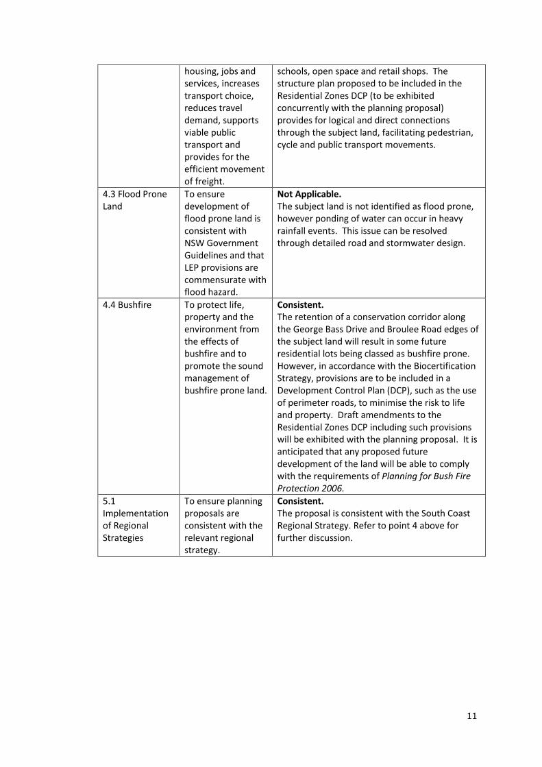
4.3 Flood Prone Land
To ensure development of flood prone land is consistent with NSW Government Guidelines and that LEP provisions are commensurate with flood hazard.
Not Applicable. The subject land is not identified as flood prone, however ponding of water can occur in heavy rainfall events. This issue can be resolved through detailed road and stormwater design.
4.4 Bushfire To protect life, property and the environment from the effects of bushfire and to promote the sound management of bushfire prone land.
Consistent. The retention of a conservation corridor along the George Bass Drive and Broulee Road edges of the subject land will result in some future residential lots being classed as bushfire prone. However, in accordance with the Biocertification Strategy, provisions are to be included in a Development Control Plan (DCP), such as the use of perimeter roads, to minimise the risk to life and property. Draft amendments to the Residential Zones DCP including such provisions will be exhibited with the planning proposal. It is anticipated that any proposed future development of the land will be able to comply with the requirements of Planning for Bush Fire Protection 2006.
5.1 Implementation of Regional Strategies
To ensure planning proposals are consistent with the relevant regional strategy.
Consistent. The proposal is consistent with the South Coast Regional Strategy. Refer to point 4 above for further discussion.
12
Section C- ENVIRONMENTAL, SOCIAL and ECONOMIC IMPACT
7. Is there any likelihood that critical habitat or threatened species, populations or
ecological communities, or their habitats, will be adversely affected as a result of
the proposal?
The subject land has been certified for development through a biodiversity
certification process in accordance with the Threatened Species Conservation Act
1995. The Biocertification Agreement conferred by the Minister for the Environment
authorises the removal of vegetation listed as an endangered ecological community
within the identified development area on the grounds that sufficient offset areas
will be provided and protected in perpetuity.
The planning proposal implements a requirement of the Biocertification Agreement
by proposing to rezone an identified conservation corridor to the E2 Environmental
Conservation zone.
The planning proposal is supported by draft amendments to the Residential Zones
DCP, including provisions for a perimeter road, shared pathway, open car parking
area, or the like, to be provided along the full length of the conservation area. This
will further minimise potential impacts of development on the conservation area.
8. Are there any other likely environmental effects as a result of the planning
proposal and how are they proposed to be managed?
Bushfire
The removal of the bulk of vegetation within the development area minimises the
risk to bushfire for many existing residential lots in Broulee. However, the retention
of a conservation corridor along the George Bass Drive and Broulee Road edges of
the subject land will result in some future residential lots being classed as bushfire
prone. The planning proposal is supported by draft amendments to the Residential
Zones DCP, including provisions for a perimeter road, shared pathway, open car
parking area, or the like, to be provided along the full length of the conservation
area. This will assist in minimising the risk to life and property from bushfire.
Detailed assessment of proposed development in accordance with Planning for Bush
Fire Protection 2006 will be undertaken at the development application stage.
Heritage and Aboriginal Archaeological Assessment
There are no heritage items on the subject land. The land immediately to the south
contains a heritage item, being an Aboriginal Canoe Tree. Numerous aboriginal
objects or places have been recorded in the vicinity of the subject land. Given the
undeveloped nature of the land, it is likely that further Aboriginal objects or places
may be found on the land. Prior to any development being permitted, Aboriginal
Heritage Impact Permits would be required, in accordance with the requirements of
the National Parks and Wildlife Act 1974. Such development is Integrated
13
Development under the Environmental Planning and Assessment Act 1979.
Consultation with the National Parks and Wildlife Service will be undertaken as part
of exhibition of this planning proposal.
Flooding and Stormwater
The subject land is not identified as flood prone, however ponding of water can
occur in heavy rainfall events. This issue can be resolved through detailed road and
stormwater design.
9. How has the planning proposal adequately addressed any social and economic
effects?
Economic Impact
The subject land has been zoned for residential development for many decades,
however development has been unable to be progressed due to the listing of an
endangered ecological community on the land. To facilitate development a
Biocertification Strategy was undertaken and a Biocertification Agreement has now
been conferred upon the land.
The planning proposal implements a requirement of the Broulee Biocertification
Agreement and proposes zoning and lot size changes that will facilitate development
activity in a form that is both suitable for the land and will result in greater housing
diversity for Broulee. Increased densities will support commercial activity in the
local business zoned land. Significant construction activity in the development area
that will be enabled by this planning proposal will be a boost to economic
development in the Shire.
Social Impact
Broulee currently provides approximately 1200 dwellings (including dwellings within
the Banksia Retirement Village). The majority of dwellings are detached dwellings on
lots ranging generally between 600m² and 850m². Most lots appear to be over
700m² in size however the more recent subdivisions include many smaller lots. With
the exception of the Banksia Retirement Village, most medium density housing in
Broulee is relatively older stock.
It is estimated that the development yield in the subject development area is
approximately 420 dwellings. With an increase in the area of R3 Medium Density
Residential zoning, some of these new dwellings will be in the form of multi-dwelling
housing or residential flat buildings. This will provide greater housing diversity in
Broulee. Greater housing diversity provides increased choice for people in terms of
the cost and type of housing available in a local area. This can facilitate a more
diverse resident population, which has the potential to foster a more healthy and
sustainable community.
14
Section D- STATE and COMMONWEALTH INTERESTS
10. Is there adequate public infrastructure for the planning proposal?
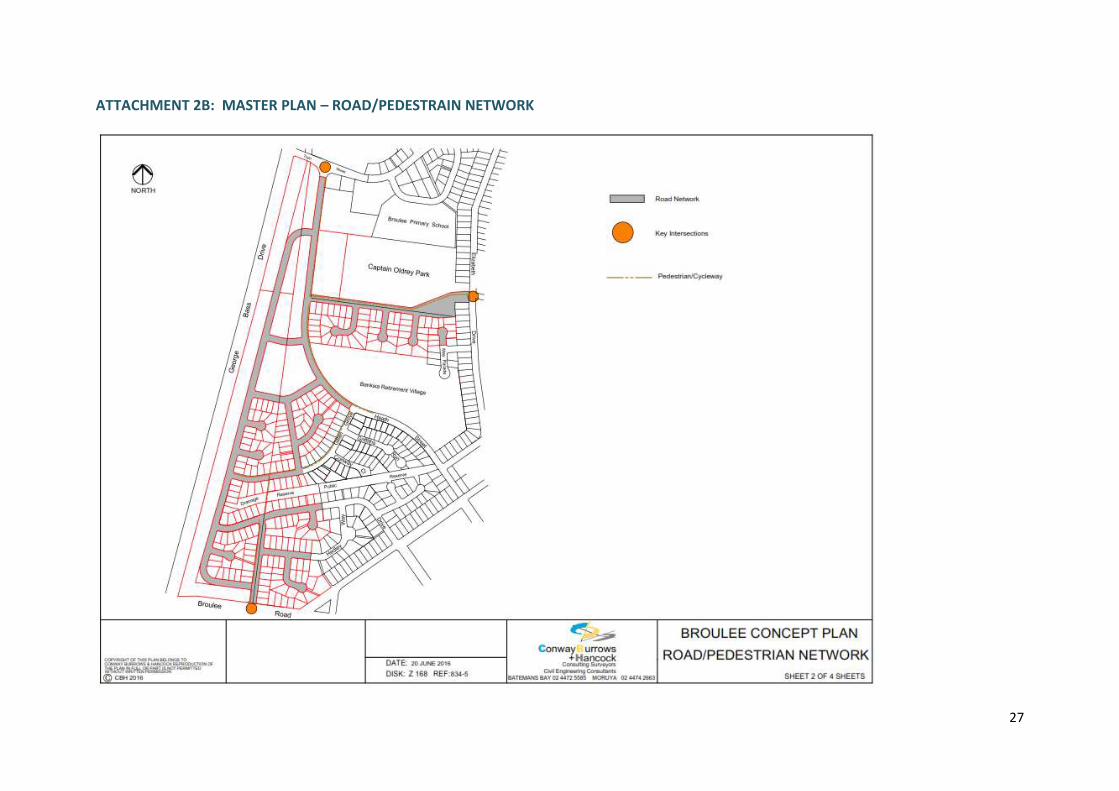
Access – The subject land can be serviced by roads from a number of locations,
including Train Street, Broulee Road, Heath Street and Elizabeth Drive. However,
upgrades of key intersections will likely be required as a result of the development.
A Road/Pedestrian Network has been developed to support the planning proposal,
identifying those key intersections where some treatment may be required and the
primary pedestrian routes through the development area. A Traffic and Transport
Study of the impact of full development of the subject land will be required to be
undertaken prior to any further development of the land to determine the extent of
traffic infrastructure upgrades that will be required. Issues to consider in the Traffic
and Transport Study will include:
Appropriate road widths, road reserve widths and splay corners to
accommodate bus routes, laybys and shared paths where required (eg. Heath
Street);
Need for, location and design of roundabouts;
Need for, location and design of parking areas, including possible on-road
parking along the southern edge of Captain Oldrey Park;
Need for, location and design of any required traffic calming measures;
Pedestrian desires lines, including for school students, and any safety
measures required to be implemented;
Access for construction traffic to minimise impacts on existing residential
areas.
A Section 94 Contributions Plan or Voluntary Planning Agreement may also need to
be prepared to fund the required infrastructure upgrades.
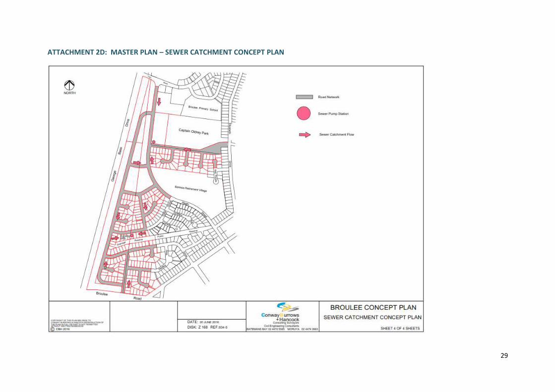
Water and Sewer – The subject land can be serviced by water and sewer, however
the scale of the development will warrant a significant upgrade of the local sewerage
system. The development will contribute to this upgrade through Section 64
Contributions (headworks charges). A Sewer Catchment Concept Plan has been
developed to support the planning proposal identifying the location of pumping
stations that the sewer catchment flow.
Stormwater – As noted above, there are some issues with ponding of water that
need to be addressed through road and stormwater design prior to any
development taking place. A Drainage Concept Plan has been developed to support
the planning proposal outlining the strategic concepts to manage stormwater from
development of the land, demonstrating that stormwater flows will be directed to
detention basins and open space areas within and adjoining development areas.
This concept will be further developed when detailed drainage design is undertaken
15
at the development application stage to ensure development will have minimal
impacts on coastal processes.
Open Space – The planning proposal identifies additional public open space to be
provided in the development area. The additional open space provides both an
expansion of an existing district/regional sporting facility and opportunity for
additional passive local open space. The concept plan demonstrates than all new
residents will be located within 400m of public open space, a standard planning rule-
of-thumb that facilitates active lifestyles.
The concept road layout includes new perimeter roads for Captain Oldrey Park,
providing greater passive surveillance of the park. Whilst this improves safety and
security at the park, the future design and location of recreation facilities at Captain
Oldrey Park will need to consider safety issues to avoid potential conflicts between
park users and passing traffic.
11. What are the views of State and Commonwealth public authorities consulted in
accordance with the gateway determination?
Consultation on the planning proposal has been undertaken with the Office of
Environment and Heritage and the Rural Fires Service. These consultations will be
ongoing throughout the planning proposal process.
16
PART 4- MAPPING
Figure 1: The subject land
17
Figure 2: Aerial image of the subject land
18
Figure 3: Proposed change to ELEP 2012 Land Zoning Map
Rezone from R2 Low Density Residential
to E2 Environmental Conservation –
Sheets LZN_011B and LZN _012A
Rezone from R2 Low Density
Residential to R3 Medium
Density Residential – Sheets
LZN_011B and LZN _012A
19
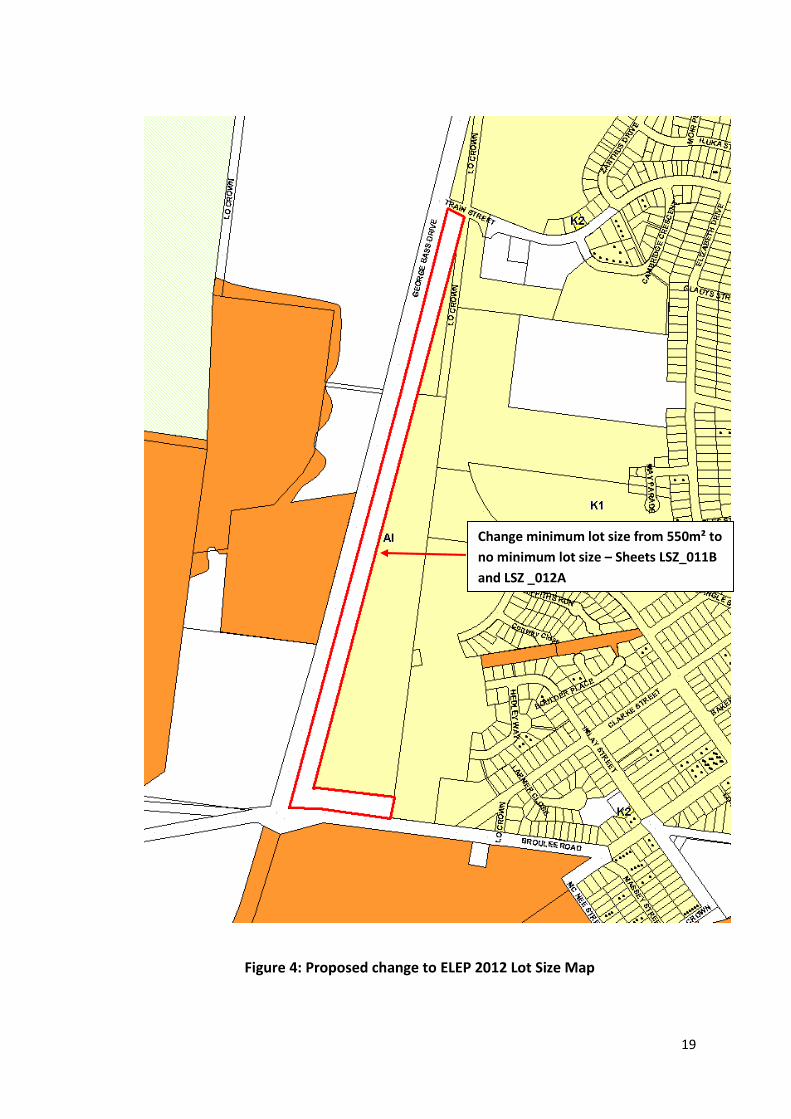
Figure 4: Proposed change to ELEP 2012 Lot Size Map
Change minimum lot size from 550m² to
no minimum lot size – Sheets LSZ_011B
and LSZ _012A
20
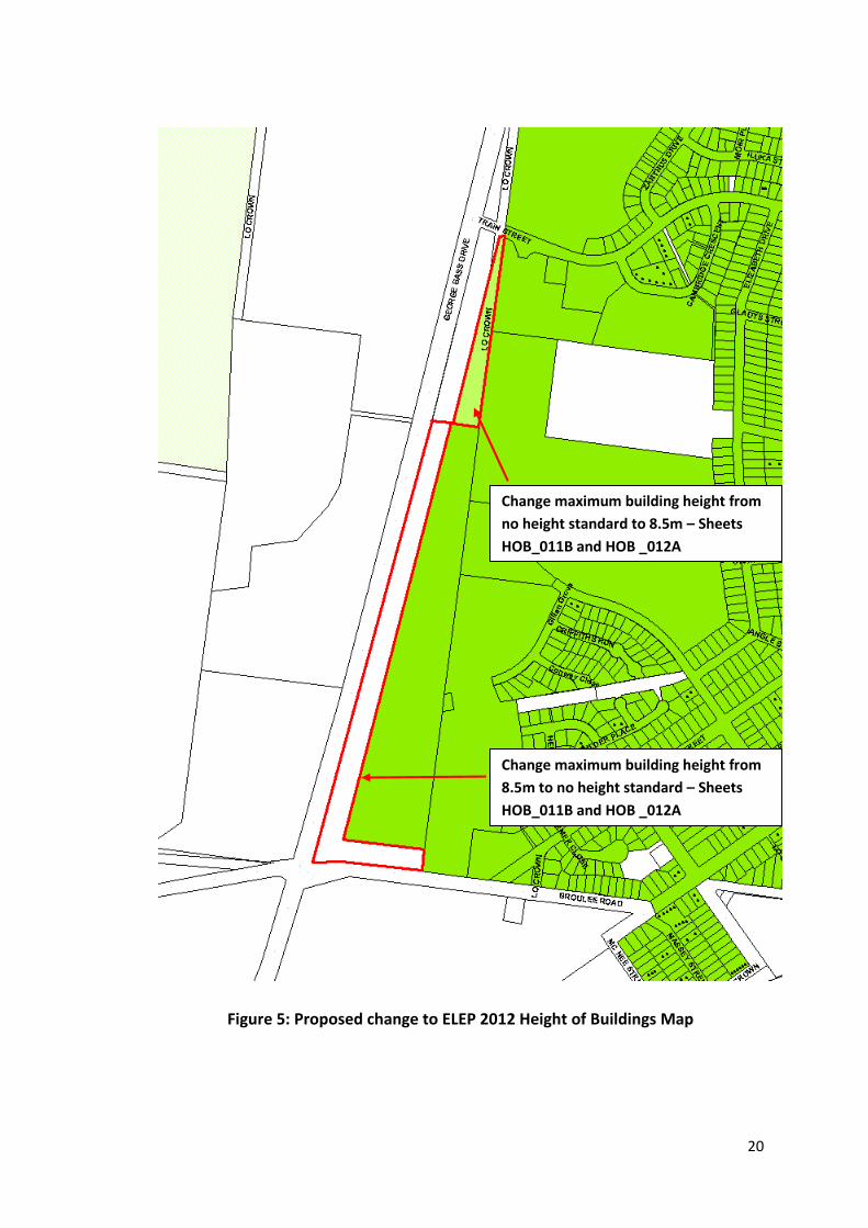
Figure 5: Proposed change to ELEP 2012 Height of Buildings Map
Change maximum building height from
8.5m to no height standard – Sheets
HOB_011B and HOB _012A
Change maximum building height from
no height standard to 8.5m – Sheets
HOB_011B and HOB _012A
21
PART 5- COMMUNITY CONSULTATION
In accordance with Section 57(2) of the Environmental Planning and Assessment Act 1979,
this planning proposal must be approved prior to community consultation being undertaken
by the local authority. The planning proposal is intended to be exhibited for a 28 day period.
Consultation on the proposed rezoning, minimum lot size and maximum building height
amendments will be to inform and receive feedback from interested stakeholders. To
engage the local community the following will be undertaken:
Notice in the local newspaper;
Exhibition material and relevant consultation documents to be made available at the
libraries and Council’s Administration Building;
Consultation documents to be made available on the Council’s website; and
Letters advising adjoining landowners on the proposed rezoning and minimum lot
size amendment and other stakeholders that Council deem relevant to this proposal.
Additional consultation measures may be determined appropriate and added to the above
as part of the gateway determination.
At the close of the consultation process, Council officers will consider all submissions
received and present a report to Council for their endorsement of the proposed lot size
amendment before proceeding to finalisation of the proposal.
PART 6- PROJECT TIMELINE
Anticipated commencement date (date of Gateway determination) August 2016
Anticipated timeframe for the completion of technical information (if required)
N/A
Timeframe for government agency consultation September 2016
Commencement and completion dates for public exhibition period October 2016
Timeframe for the consideration of submissions November 2016
Timeframe for consideration of a proposal post exhibition November 2016
Date of submission to the Department to finalise the LEP December 2016
Anticipated date the RPA will make the plan (if delegated) N/A
Anticipated date the RPA will forward to the department for notification
January 2017
22
ATTACHMENT 1: PROPOSED AMENDMENTS TO RESIDENTIAL ZONES DCP
The following new provisions are proposed to be included in the Residential Zones DCP.
3.2 Subdivision and development of certain land at Broulee
Note: This section applies to the land identified in Map 10 in Schedule 1 of this Plan in
addition to all other relevant provisions of this Plan. Intent:
To ensure that development of land at Broulee is consistent with the Broulee Biocertification Strategy and provides for a diversity of housing opportunities.
Development Controls:
Performance Criteria Acceptable Solution
P1 Development of the subject land is designed to be generally consistent with the Broulee Concept Plan included in Schedule 4 of this Plan.
A1 The subdivision layout and road network shall include, for the full length of the conservation corridor along George Bass Drive and Broulee Road, one or a combination of the following:
A perimeter road
A shared cycle/pathway
Open car parking areas to ensure adequate separation between residential development and the conservation area for bushfire protection and to minimise environmental impacts.
6.3 Retention of habitat features on certain land at Broulee
Note: This section applies to the land identified in Map 10 in Schedule 1 of this Plan in
addition to all other relevant provisions of this Plan. Intent:
To ensure that development of land at Broulee is consistent with the Broulee Biodiversity Certification Strategy and facilitates, where possible the retention of habitat trees.
Development Control: P1 Within the development area there is no requirement to retain existing habitat
features. However, in designing subdivision layouts and medium density developments, Council encourages, where possible and feasible, the retention of some habitat features, including hollow bearing trees.
23
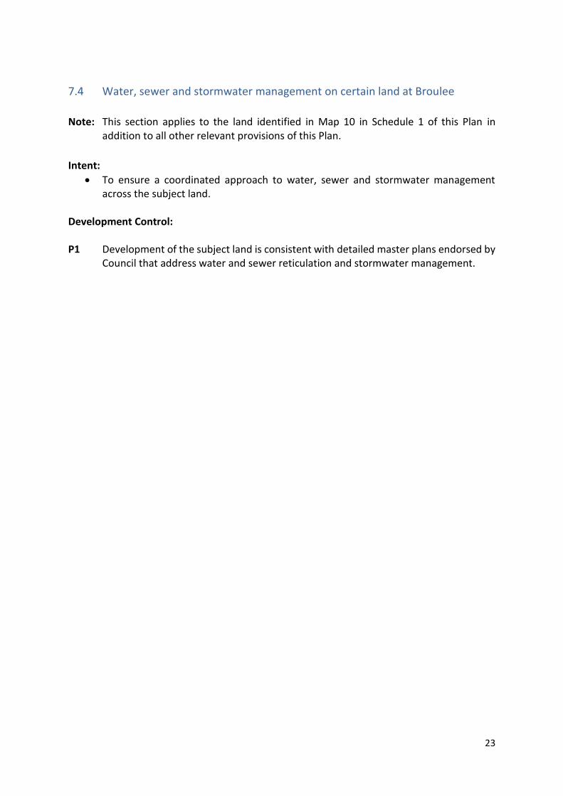
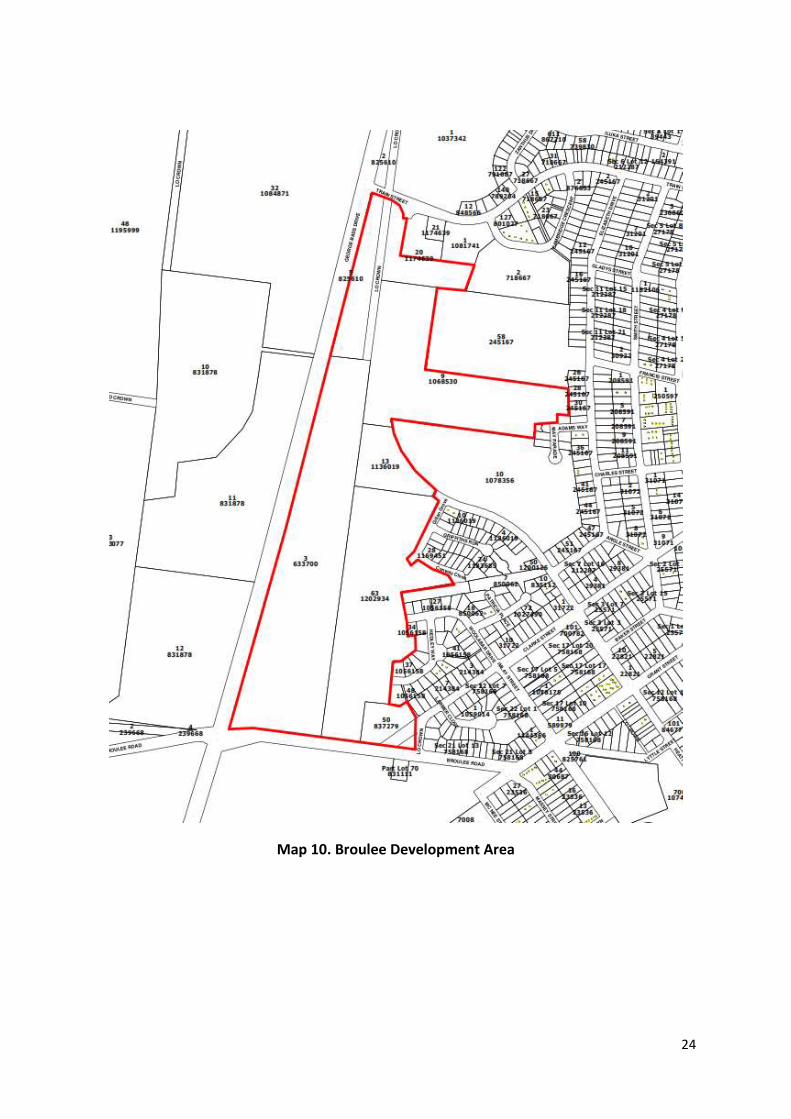
7.4 Water, sewer and stormwater management on certain land at Broulee
Note: This section applies to the land identified in Map 10 in Schedule 1 of this Plan in
addition to all other relevant provisions of this Plan.
Intent:
To ensure a coordinated approach to water, sewer and stormwater management across the subject land.
Development Control: P1 Development of the subject land is consistent with detailed master plans endorsed by
Council that address water and sewer reticulation and stormwater management.
24
Map 10. Broulee Development Area
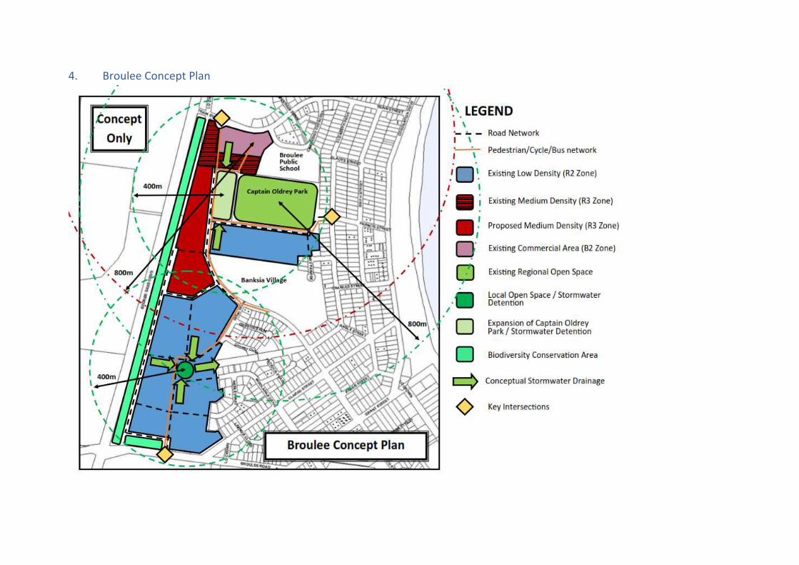
4. Broulee Concept Plan
26
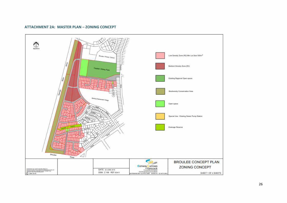
ATTACHMENT 2A: MASTER PLAN – ZONING CONCEPT
27
ATTACHMENT 2B: MASTER PLAN – ROAD/PEDESTRAIN NETWORK
28
ATTACHMENT 2C: MASTER PLAN – DRAINAGE CONCEPT PLAN
29
ATTACHMENT 2D: MASTER PLAN – SEWER CATCHMENT CONCEPT PLAN