Embed Size (px)
Citation preview

7/25/2019 Plate Tectonics Where the Action Is
http://slidepdf.com/reader/full/plate-tectonics-where-the-action-is 1/6

7/25/2019 Plate Tectonics Where the Action Is
http://slidepdf.com/reader/full/plate-tectonics-where-the-action-is 2/6
Skylab 4 photo with view nort h up the Rio G rande rift from altitude of 432 km over
central New Mexico. The rift crosses a wide zone with
a
strong northeast trending
grain. It passes through the Jem ez lineam ent one of the most active volcanic zones in
the
U.S.
for the past
1
million years. Note the Jemez caldera top left.
SCIENCE IDEA
Plate Tectonic
Where the
Action I
by
Bob
R ie c ke r
u r ing your l i f e t im e , Nor th
A m e r i c a a n d E u r o p e w ill
separate by the average height
of a person; the Pacific Ocean will
shrink by the average width of a single-
family home. Next year , Los Angeles
will move closer to San Fran cisco by the
length of your little finger. Last year,
some 100 cubic kilometers of new earth
crust were born at crests of ocean r idges.
In the last 76 million years, the north
magnetic pole has reversed its polarity at
least 171 times, and in the last 100
million years , a n a rea equal to the size of
the Pacif ic Oce an basin ha s disappeared
beneath surrounding continents.
Plate tectonics is the unifying concept
in geosciences. Th e Earth's surface is
divided into a mos aic of possibly 10 to
12 large (and many smaller) rigid, mov-
ing plates, varying from 10 to 100
kilometers thick and often many thou-
sand s of kilometers wide. The plates that
move apart on our globe must coll ide
somewhere, and when they do, ear th-
quakes and volcanism remind us of tur-
moil . In an ocean chain over 30,000
kilometers long, new earth crust forms
to add rock to continents. At other
places, mountains rise because of plate
collisions.
W e r i d e n o r t h w e s t w a r d o n o u r
namesake, the North American plate ,
which extends from the Pacific coast to
the middle Atlantic Ocean. We grind
against the Pacific plate along the San
Andreas Fault in California . Plate mo-
tion insures th at, in 5 0 million years, Lo s
Angeles will becom e a western su bu rb of
San Francisco. That tr ip is not easy
geologically, as m ajor earthqu akes attest
periodically.
Th e gurus of plate tectonics predicted
at the paradigm's inception, about 15
years ago , that the new theory w ould re-
quire rewriting of geology textbooks. In
fact, that's h app ened . But we are just
now be g inn ing to unde r s t a n d how
dynamic and changing the Earth 's sur-
face really is.
Problems remain. The simple model
of 100-kilo meter-thick , rigid plates, or
rafts, floating about on "greasy skids" of
the Earth's upper mantle looks naive.
Seismic research based on study of
propagation of elastic waves through the
Earth suggests that continents have
much deeper roots. Also, we don't really
know yet what mak es the plates go Cer-
tainly the Earth 's natural heat engine
drives the raf ts, but how, and over what
vertical dimensions? The Earth loses
heat, generated mainly by radioactive
decay, at a rate about f ive t imes more
than the rate at which man uses energy
( 2
1 12 calories/second). How long
have plates moved over the Earth 's su
face since the planet's birth? As t
Earth 's heat engine cools, are plate m
tions slowing, and is mountain buildi
c e a s i n g ? O f te n e a r t h q u a k e s a
sometimes volcanism appear in the
ter ior of plates, not only along the
edges as predicted by the theory.
Normally the hottest spots are whe
the a c t ion i s . Tha t ' s whe r e p l a t
originate or where they collide or a
consumed. At ocean spreading cente
new crust fo rms and enlarges the plat
One such hot zone cente rs a long t
Rio G ran de r if t. A r ift is a long, narro
usua l ly dow n-fau l ted va lley in t
Earth 's crust . The Rio Grande r if t e
tends from Leadville . C olora do, throu
New Mexico, and ac ross the border in
n o r t h e r n M e x i c o . A l o n g t h i s 8 0
kilometer rift, significant volcanis
earthquake activity, uplif t , and separ
tion have occurred during the last
million years.
F o r t h e p r e c e d i n g h u n d r e d s
mill ions of years, the entire zone alo
which the Rocky Mounta ins s tand h
been an active moun tain building regio
Then 30 million years ago, region
separation initiated rifting. The r
opened along a ser ies of northward a
no r the a s tw a r d f l a ws o r l i ne a m e n
which reach down through the overlyi
LOS ALAMOS SCIENCE Summer 1980

7/25/2019 Plate Tectonics Where the Action Is
http://slidepdf.com/reader/full/plate-tectonics-where-the-action-is 3/6 42
LOS L MOS SCIENCE
umme r

7/25/2019 Plate Tectonics Where the Action Is
http://slidepdf.com/reader/full/plate-tectonics-where-the-action-is 4/6
SCIENCE
IDE
sedimentary cover. The series of deep
basins that eventually formed in the rift
now contain th ousa nds of meters of sedi-
ment and volcanic fill.
The deeply cutting flaws that cross
the rift are zones of weakness that
probably extend dee p into the Earth s
mantle. They leak vast quantities of
molten rock into and through the crust.
The Jemez lineament, which extends
across the Jemez caldera northeast , was
especially active volcanically during the
last 10 million yea rs as indicated by
large volunles of young volcanic rocks
blanketing the surface. Many of these
volcanics. silicic in composition, erupted
during violent explosions much larger
than modern man has seen. Layers of
fine ash from some of the eruptions
reached as far east as Iowa and Illinois
before falling from the atmosphere. The
giant scale of these events can be im-
agined as one rides past the Jemez
caldera in the center of the Jemez m oun-
tains. This grassy pastureland, more
than 15 kilometers in diameter, is the
remnant of a large volcano.
The scale of the Rio Grande rift is
also quite large. Separation across the
rift is as wide as 10 kilometers and uplift
exceeds many thousand meters . Does
this mean that the North American plate
is being torn asunder in the southwestern
Uni ted Sta tes? Some geoscien t i s t s
believe so, and in their jargon, the rift
represents an incipient spreading center
where new earth crust forms and shoves
aside older rock.
Major crustal stretching occurred not
only along the Rio Grande rift but over
the entire southwestern portion of the
United S tates. We see evidence of the
stretching in the patterns of faulting and
the appearance of volcanic rocks in the
Basin and Range provinces in Arizona
and Nevada to the west and in the High
Lava Plains of Oregon and California to
the north. The exact cause of the
stretching remains obscure and c
troversial. It must involve interacti
during the last fraction of geologic ti
am o n g t h e N o r t h A m er i can an d Paci
p la tes and th e
Faral lon plate, which
between them, bu t s ince has been co
sumed as the sou thwes tern par t
of
o
raft overrod e i t . These in terac t ions a
p ro d u ced an d n o w d r i v e t h e San A
d r e a ~ aul t sp l i t t ing Cal i fo r n ia .
There is no question that episo
rifting continues today in New Mexi
as evidenced by the abundant fa
scarps, earthquakes, high heat flo
m o d ern e l ev a t i o n ch an g es , r ec
volcanism, and the geophysical eviden
of an a noma lous thin cru st beneath
rift.
The earliest written record of ear
quake activity in New Mexico is of
ear thquake swarm descr ibed by an ar
surgeon cam ping near So co rro in l
1849
Most of the recent earthqua
have occu rred in a 15 0-kilom eter sect
between Belen and Socorro, New M
ico. During the last 20 years, seism
record ing suggests a very low level of
tivity. The level is surprising in view
major crustal m ovements in the past a
the presence of modern fault sca
along the edges of the rift . The rift n
appears quiet, but seismically pregna
Detailed seismic studies continue
New Mexico with measurements perf
med by LASL. the New Mexico Instit
of Mining and Technology, and
Albuquerque Seismological Laborato
of the U.S. Geological Survey. Ea
group installed seismometers for d
ferent reasons, but all cooperate clos
in trying to learn more about seismic
tivity in New Mexico. One motivat
for LA SL s seismic research has been
study natural earthquake act ivi ty n
the hot dry rock geothermal energy
periment at
Fenton Hill . so that m
made and natural events can be d
tinguished. Also construction of n
LOS ALAMOS SCIENCEISummcr 198
7/25/2019 Plate Tectonics Where the Action Is
http://slidepdf.com/reader/full/plate-tectonics-where-the-action-is 5/6
SCIENCE
IDEAS
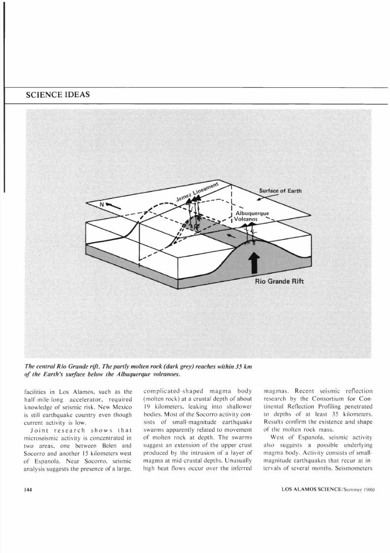
The central Rio Grande rift. T he partly molten rock (dark grey) reaches within 35 km
of the Earth s surface below the Albuquerque volcanoes.
facilities in Los Alamos. such as the
hal f -mi le- long accelera tor , requ i red
knowledge of seismic risk. New Mexico
is still earthquake country even though
current activity is low.
J o i n t r e s e a r c h s h o w s t h a t
microseismic activity is concentrated in
two areas, one between
Beten and
Socorro and another 15 kilometers west
of Espanola. Near Socorro, seismic
analysis suggests the presence of a large,
c o m p l i c a t e d - s h a p e d m a g m a b o d y
molten rock) at a crustal depth o f about
19 kilometers, leaking into shallower
bodies. Most of the Socorro activity con-
sis ts of small-magnitude earthquake
swar ms apparent ly related t o movement
of molten rock at depth. The swarms
suggest an extension of the upper crust
produced by the intrusion of a layer of
mag ma at mid-crustal depths. Unusual ly
high heat flows occur over the inferred
m ag m as . Recen t s e i s m i c r e f l ec t
research by the Consort ium for C
tinental Reflection Profiling penetra
to depths of at least 35 ki lomet
Resul ts confirm the exis tence an d sh
of the molten rock mass.
West of Espanola, seismic activ
also suggests a possible underly
mag ma body. Act ivi ty consis ts of sm
magnitude earthquakes that recur at
tervals of several months. Seismome
LOS ALAMO S SC1ENCElSu1nrner

7/25/2019 Plate Tectonics Where the Action Is
http://slidepdf.com/reader/full/plate-tectonics-where-the-action-is 6/6
SCIENCE IDE
record a few swarm-like sequences. In-
terestingly. LASL researchers recently
noted a major re la t ive subs idence
nor thwes t o f Espanola associa ted
spat i a l ly with the ear t hqua ke belt .
Geodetic releveling analysis reveals a
maximum subsidence of about 5 cen-
timeters between surv eys perform ed in
1934
and 1939. Researchers suggest
that the sinking and the associate d ear th-
quakes originate in deflation of a shallow
magma body. Continued studies will
help to identify the processes responsible
for regional extension in the Southwest.
Plate movements not only create
earthquakes and produce volcanism;
they also determine where mineral
deposits form. In addition, most geother-
mal energy resources originate as a
result of plate interaction. The LA SL hot
dry rock experiment on Fenton Hill is
successful partly because of its location
on the edge of the R io Gra nd e rift. Plate
travels determine whether diamonds
form in Ark ansa s or gold appe ars in
California. Many ore bodies, for exam-
ple. occur at present or past boundaries
of crustal plates.
Geology is a young discipline with a
rapidly increasing pace of surprising dis-
coveries. Only astronomy shares with it
the complexities of scale and time. In 2
A. D. Senec a wrote, It is useful to be
assured that the heavings of the Earth
are not the work of angry deities. These
phenomena have causes all their own.
Tw o millennia later we ar e just beg in-
ning to understand what those causes
are. Moreov er, we are just beginning to
exploit our understanding through im-
proved exploration for mineral and
energy resources. Few theories have
made such an impact on their dis-
ciplines, and few disciplines, stimulated
by new theories, have had such an im-
pact on energy technologies as has plate
The Rio G rande Rift The crosshatched areas indicate the Rift itself and the stipp
tectonics on the geosciences.
areas indicate surface volcanics
LOS L MOS SCIENCEISummcr 198