Embed Size (px)
Citation preview
Platte West Wellhead Protection Plan
Created by HDR Engineering, Inc. and JEO Consulting Group, Inc. for Metropolitan Utilities District
2013
Metro Utilities District Platte West Wellhead Protection Plan i
CONTENTS SECTION 1: INTRODUCTION ................................................................................................. 1 1.1 Wellhead Protection Plan Program Activities ................................................................................. 1 1.2 Wellhead Protection Plan – Intent and Use ..................................................................................... 2 1.3 Metropolitan Utilities District Wellhead Protection Contacts ......................................................... 2 SECTION 2: METROPOLITAN UTILITIES DISTRICT WATER SYSTEM .................... 3 2.1 History of Metropolitan Utilities District......................................................................................... 3 2.2 Metropolitan Utilities District Water Service .................................................................................. 3 2.3 Metropolitan Utilities District Water Rights .................................................................................... 5 2.4 Platte West Water Treatment Facility .............................................................................................. 5 SECTION 3: METROPOLITAN UTILITIES DISTRICT WELLHEAD PROTECTION AREA ............................................................................................................................................. 8 3.1 Land Cover Use ............................................................................................................................. 11 SECTION 4: POTENTIAL CONTAMINANT SOURCE INVENTORY ............................ 14 4.1 Registered Water Wells ................................................................................................................. 14 4.2 Regulated Facilities ........................................................................................................................ 16 4.3 Oil and Gas Wells .......................................................................................................................... 32 4.4 State Fire Marshal Registered Hazardous Sites ............................................................................. 34 4.5 Underground Storage Tanks .......................................................................................................... 36 4.6 Surface Water Quality.................................................................................................................... 38 SECTION 5: MANAGEMENT STRATEGIES ...................................................................... 39 5.1 Existing Well Field Management Practices ................................................................................... 39 5.2 Existing Land Use Controls ........................................................................................................... 40 5.3 Potential Future Management Strategies ....................................................................................... 41 SECTION 6: EMERGENCY AND CONTINGENCY PLANS.............................................. 43 6.1 Emergency Plans ............................................................................................................................ 43 6.2 Spills .............................................................................................................................................. 43 6.3 Operations Emergency Plans ......................................................................................................... 44 6.4 Supervisory Control and Data Acquisition Emergency Plans ....................................................... 45 6.5 Standby Capacity During Area-Wide Loss of Electricity .............................................................. 46 6.6 Contingency Plans ......................................................................................................................... 46 6.7 Long-Term Planning ...................................................................................................................... 48 SECTION 7: PUBLIC EDUCATION AND NOTIFICATION .............................................. 49 7.1 Metropolitan Utilities District Platte West Wellhead Advisory Committee .................................. 49 7.2 Public Comment Period and Public Board Meeting ...................................................................... 51 SECTION 8: REFERENCES .................................................................................................... 52
Metro Utilities District Platte West Wellhead Protection Plan ii
TABLES Table 1: Metropolitan Utilities District Wellhead Protection Contacts ........................................................ 2 Table 2: Metropolitan Utilities District Water Rights................................................................................... 5 Table 3: Metropolitan Utilities District Water System – General Water System Information ..................... 6 Table 4: Metropolitan Utilities District Platte West Water Treatment Facility Information ........................ 6 Table 5: Metropolitan Utilities District Platte West Water Treatment Facility – Contact Information ........ 7 Table 6: Platte West Wellhead Protection Area Land Use Cover .............................................................. 12 Table 7: Platte West Regulated Facilities ................................................................................................... 27 Table 8: Platte West State Fire Marshal Hazardous Sites ........................................................................... 34 Table 9: Platte West Underground Storage Tanks ...................................................................................... 36 Table 10: Nitrate Levels at Platte River Gage at Louisville ....................................................................... 38 Table 11: Metropolitan Utilities District Natural Gas Engine Driven Pumps ............................................ 46 Table 12: Metropolitan Utilities District Platte West Wellhead Advisory Committee ............................... 50
FIGURES Figure 1: Metropolitan Utilities District Water Treatment Facilities ............................................................ 4 Figure 2: Metropolitan Utilities District Platte West Wellhead Protection Area .......................................... 9 Figure 3: Platte West Particle Tracking ...................................................................................................... 10 Figure 4: Platte West Land Use Cover........................................................................................................ 13 Figure 5: Platte West Registered Water Wells ............................................................................................ 15 Figure 6: Platte West Clean Air Act Facilities ............................................................................................ 17 Figure 7: Platte West Integrated Waste Management Facilities ................................................................. 18 Figure 8: Platte West Leaking Storage Tank Facilities ............................................................................... 19 Figure 9: Platte West Livestock Waste Control Facilities .......................................................................... 20 Figure 10: Platte West Onsite Wastewater Treatment Facilities................................................................. 21 Figure 11: Platte West NPDES Permits and Compliance Facilities ........................................................... 22 Figure 12: Platte West Petroleum Release Remediation Facilities ............................................................. 23 Figure 13: Platte West Release Assessment Facilities ................................................................................ 24 Figure 14: Platte West SARA Title III Facilities ........................................................................................ 25 Figure 15: Platte West Underground Injection Control Facilities .............................................................. 26 Figure 16: Platte West Oil and Gas Wells .................................................................................................. 33 Figure 17: Platte West State Fire Marshal Hazardous Sites ....................................................................... 35 Figure 18: Platte West Underground Storage Tanks................................................................................... 37
Metro Utilities District Platte West Wellhead Protection Plan 1
SECTION 1: INTRODUCTION Wellhead Protection is the management of the land surrounding a water supply well to prevent contamination of the water supply. The Safe Drinking Water Act of 1974, as amended (SDWA), recommended that public water supply systems develop Wellhead Protection Plans (WHPPs). The SDWA defines a wellhead protection area as: "the surface and subsurface area surrounding a water well or well field, supplying a public water system, through which contaminants are reasonably likely to move toward and reach such water well or well fields." In response to this recommendation, the State of Nebraska (State) adopted the Nebraska Wellhead Protection Area Act in 1998, by Nebraska Legislature Bill (LB) 1161. This act’s main goal is to minimize the amount of potentially polluting activities occurring on the designated lands that surround public water supply wells. Wellhead protection is a voluntary program in Nebraska. Public Water Supply Systems (PWSSs) in Nebraska have the option of developing a WHPP. The WHPP is generally written by a local community official or a technical advisor and provides the PWSS with a detailed account of the potential threats to the system and general management strategies, including ordinances related to wellhead protection.
The WHPP provides a detailed account of the potential threats to the Platte West Water Treatment facility and a summary of existing and recommended management strategies. Understanding the importance of protecting the water supply source, the Metropolitan Utilities District (MUD or the District) has developed this WHPP for the Platte West Water Treatment facility.
1.1 WELLHEAD PROTECTION PLAN PROGRAM ACTIVITIES In Nebraska, the WHPP program is administered by the Nebraska Department of Environmental Quality (NDEQ). The process for developing a WHPP includes five steps, as summarized below:
1. Delineate the WHPA – The WHPA can be calculated from information such as geologic materials and annual pumping rates of the wells. A WHPA map can be computer-generated from NDEQ to depict the approximate path groundwater or a contaminant in groundwater may take to reach a well. The flow lines are associated with 20-year flow lines to determine the WHPA boundary.
2. Potential contaminant source inventory – A potential contaminant source inventory is conducted to determine any locations, activities, or structures that may pose a threat to drinking water. Inventories should be compiled from existing databases.
3. Contaminant source management – Management of a groundwater supply should be enacted upon to minimize the threat to drinking water. The community can involve multiple management steps such as zoning restrictions on specific land uses, purchasing of land or conservation easements, ordinances, and voluntary actions including working with land owners to encourage best management practices (BMPs).
4. Emergency, contingency, and long-term planning – A plan should be developed to enable a community to react and provide a replacement source of drinking water in events such as natural disasters, contamination, or mechanical failures. The plan should include a reference or copy of the emergency plan, a short-term temporary source, and options for obtaining a long-term source of water.
5. Educate and involve the public – Community awareness can help provide citizens with information about what can be done to protect groundwater and drinking water. This will increase the likelihood that a WHPP will be successful.
Metro Utilities District Platte West Wellhead Protection Plan 2
1.2 WELLHEAD PROTECTION PLAN – INTENT AND USE The MUD Platte West WHPP will be used to develop appropriate future plans and programs designed to help protect the water supply of the Greater Omaha Area. It shall address, at a minimum, the requirements stated in Section 1.1, above. The WHPP was not developed in response to any single specific issue, but rather was developed as a proactive approach to document existing conditions and to provide a means to develop future programs and activities aimed to reduce the potential for groundwater contamination within the WHPA.
It is recognized that the local aquifer provides water not only to the inhabitants of the Greater Omaha Area, but is also used by inhabitants that live within the WHPA. Therefore, a major component of this plan is to foster communication and partnership among all stakeholders within the WHPA.
The District currently provides some protection from the potential of off-site contamination for its water supply wells through ownership of the property immediately surrounding the wells. While property ownership provides some protection, it does not provide the recommended 20-year time-of-travel protection. The District does not have the authority to enforce or implement zoning. Developing partnerships with local jurisdictions and exploring the possibility to enact a wellhead protection overlay zone is one goal of the WHPP.
1.3 METROPOLITAN UTILITIES DISTRICT WELLHEAD PROTECTION CONTACTS Table 1 below provides contact information for agencies that are responsible for the day to day management of this plan including the establishment of the WHPP, gathering data, providing summaries, or providing technical assistance with wellhead protection activities.
TABLE 1: METROPOLITAN UTILITIES DISTRICT WELLHEAD PROTECTION CONTACTS
Agency/Role Name Title Phone/Email
MUD Russel Iwan Water Supply Engineer (402) 504-7870 [email protected]
NDEQ Ryan Chapman WHP Coordinator (402) 471-2186 [email protected]
JEO Consulting Group Jeffrey Ray Planner (402) 392-9931 [email protected]
HDR Engineering, Inc. Luca DeAngelis Hydrogeologist (816) 347-1138 [email protected]
Metro Utilities District Platte West Wellhead Protection Plan 3
SECTION 2: METROPOLITAN UTILITIES DISTRICT WATER SYSTEM
2.1 HISTORY OF METROPOLITAN UTILITIES DISTRICT MUD was created in 1913, to take control of water service to the City of Omaha. Five years later, the District was formed after being assigned responsibility for operation of the gas system. It was created by the State to provide water and natural gas to the Greater Omaha Area.
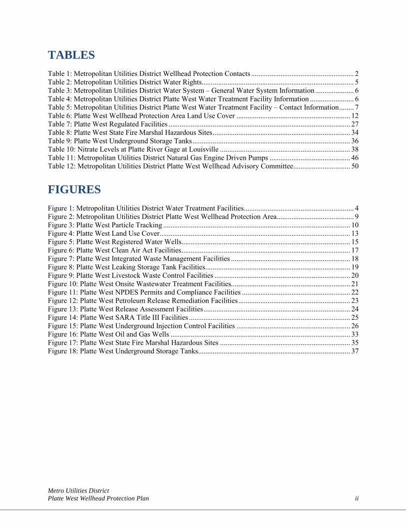
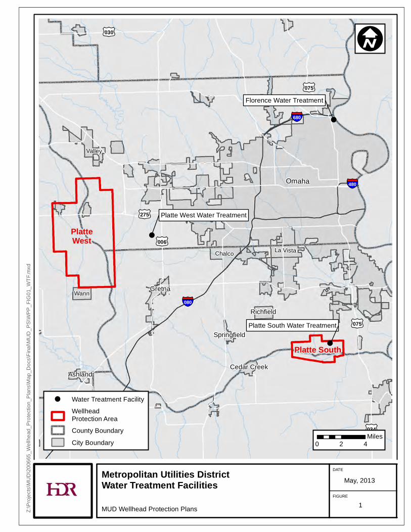
2.2 METROPOLITAN UTILITIES DISTRICT WATER SERVICE MUD provides safe drinking water to more than 200,000 customer-owners in Omaha, Bellevue, Bennington, Carter Lake, LaVista, Ralston, Waterloo, and the Papio-Missouri Natural Resources District (NRD). It is the only Metropolitan Utility District in the State. MUD began providing drinking water in 1922, with the operation of the Florence Water Treatment facility, which has a maximum day production capacity of 158 million gallons per day (mgd). The Florence Water Treatment facility obtains water from an intake in the Missouri River. In 1968, a second water treatment facility (the Platte South Water Treatment facility) was constructed south of the metropolitan area. The Platte South Water Treatment facility uses shallow wells constructed in the Platte River alluvial aquifer as the source of raw water. This facility provides MUD with a maximum day production capacity of 60 mgd. In 1971, Omaha annexed the Village of Millard, which operated wells that are constructed in the Dakota Sandstone Aquifer. MUD obtained control of these wells as a result of the annexation. These wells are operated as peak shaving wells to supplement the supply from the other sources. The only treatment for the peak shaving wells is disinfection.
In 1988, and again in 1995, maximum demand for water nearly exceeded the District’s maximum production capacity. To address this issue, an additional well field and water treatment facility (Platte West Water Treatment facility) was added to MUD’s system. In 2008, the Platte West Water Treatment facility was opened to add to the increasing demands due to MUD’s expanding customer base. In July 2008, the Platte West Water Treatment facility began operations with the capacity to treat and distribute an additional 100 mgd of potable water, for a total system capacity of 333 mgd.
Omaha’s MUD water system is now comprised of three treatment facilities: Florence Water Treatment facility, Platte South Water Treatment facility, and Platte West Water Treatment facility, shown in Figure 1. The placement of the three water treatment facilities and their alternative water supply sources create a triangle of reliability for the district’s water supply. The diversity of the District’s source of water supply provides a significant advantage to the District in its ability to use an alternative supply source in the event of an emergency in any one of the sources.
!
!
!
AshlandCedar Creek
Gretna
Richfield
Springfield
Platte West Water Treatment
Platte South Water Treatment
Florence Water Treatment
Omaha
Valley
La Vista
Wann
Chalco
£¤075
£¤275
£¤030
£¤006
£¤034
£¤075
§̈¦480
§̈¦080
§̈¦680
Platte South
PlatteWest
Metropolitan Utilities DistrictWater Treatment Facilities
MUD Wellhead Protection Plans
DATE
FIGURE
May, 2013
Z:\Pr
ojects
\MUD
\2006
65_W
ellhe
ad_P
rotec
tion_
Plans
\Map
_Doc
s\Fina
l\MUD
_PS\
WPP_
FIG01
_WTF
.mxd
I
0 2 4Miles
! Water Treatment FacilityWellheadProtection AreaCounty BoundaryCity Boundary
1
Metro Utilities District Platte West Wellhead Protection Plan 5
2.3 METROPOLITAN UTILITIES DISTRICT WATER RIGHTS MUD holds ten water rights from waters from the State. Water rights are from the Big Papillion Creek, the Platte River, the Missouri River, and the Mulhalls Regulating Pit. The Platte West well field utilizes one of the ten water rights. The use of the Platte River water right is for induced groundwater recharge (IG). Table 2 below lists additional details about MUD water right for the Platte West well field.
TABLE 2: METROPOLITAN UTILITIES DISTRICT WATER RIGHTS App Number Use Source Cur Tot Acres Priority Date Status POD Grant
Water Division Date Can / Dism Facility Name Rate RightID Downstream County GPM
A-17318 IG Platte River 0.000 10/6/1993 Active Sec: 7 T: 14 R: 10 E 1000.0000 CFS 2A Begin Wellfield - 6633 670000 Saunders 448,800 GPM A-17318 IG Platte River 0.000 10/6/1993 Active Sec: 20 T: 14 R: 10 E 1000.0000 CFS 2A End Wellfield - 6636 670050 Sarpy 448,800 GPM A-17356 Ground Water permit under the
Municipal and Rural Domestic Ground Water Transfer Act
3/1/1994 104,000,000 GPD
Water Right A-17356, a ground water permit under the Municipal and Rural Domestic Ground Water Transfer Act, limits the combined pumping rate from 42 wells. The limits placed by this permit are: a maximum instantaneous pumping rate not to exceed 104 mgd and a total annual average pumping rate not to exceed 52 mgd. In addition to the water right listed above, the well field operates under Clean Water Act Section 404 Permit (No. 199910085), which is administered by the Omaha District of the U.S. Army Corps of Engineers (USACE). This permit includes requirements for wetland and ground water elevation and quality monitoring on operation of the well field.
2.4 PLATTE WEST WATER TREATMENT FACILITY The Platte West Water Treatment facility was added to the District’s water system to help provide the necessary potable water to the expanding customer base in Omaha’s western boundary. The facility is anticipated to accommodate the needs of Omaha residents for the next 30 years or more. The well field is located on 2,230 acres of land encompassing both sides of the Platte River in Douglas and Saunders counties. The water supply is obtained from 42 production wells that pump water from the Platte River alluvial aquifer. The raw water is delivered to a treatment facility in western Douglas County through a 72-inch diameter pipeline. The treatment facility includes pre-treatment basins, lime softening for hardness, organics reduction, and iron and manganese removal, as well as filtration and disinfection. The finished water storage for the facility is 15,000,000 gallons. The facility is located on a 158-acre site northeast of the intersection of Q and 216th streets.
The 42 water supply wells are each approximately 100 feet deep and were classified through groundwater modeling (for operational purposes) as either river wells or storage wells. This classification was
Metro Utilities District Platte West Wellhead Protection Plan 6
developed through the use of a groundwater flow model, but the distinction is highly dependent on the setback distance from the river.
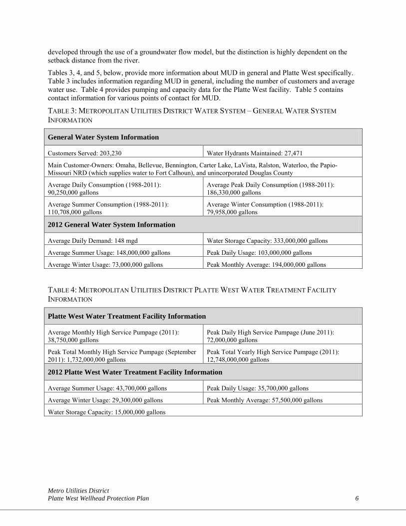
Tables 3, 4, and 5, below, provide more information about MUD in general and Platte West specifically. Table 3 includes information regarding MUD in general, including the number of customers and average water use. Table 4 provides pumping and capacity data for the Platte West facility. Table 5 contains contact information for various points of contact for MUD.
TABLE 3: METROPOLITAN UTILITIES DISTRICT WATER SYSTEM – GENERAL WATER SYSTEM INFORMATION
General Water System Information
Customers Served: 203,230 Water Hydrants Maintained: 27,471
Main Customer-Owners: Omaha, Bellevue, Bennington, Carter Lake, LaVista, Ralston, Waterloo, the Papio-Missouri NRD (which supplies water to Fort Calhoun), and unincorporated Douglas County
Average Daily Consumption (1988-2011): 90,250,000 gallons
Average Peak Daily Consumption (1988-2011): 186,330,000 gallons
Average Summer Consumption (1988-2011): 110,708,000 gallons
Average Winter Consumption (1988-2011): 79,958,000 gallons
2012 General Water System Information
Average Daily Demand: 148 mgd Water Storage Capacity: 333,000,000 gallons
Average Summer Usage: 148,000,000 gallons Peak Daily Usage: 103,000,000 gallons
Average Winter Usage: 73,000,000 gallons Peak Monthly Average: 194,000,000 gallons
TABLE 4: METROPOLITAN UTILITIES DISTRICT PLATTE WEST WATER TREATMENT FACILITY INFORMATION
Platte West Water Treatment Facility Information
Average Monthly High Service Pumpage (2011): 38,750,000 gallons
Peak Daily High Service Pumpage (June 2011): 72,000,000 gallons
Peak Total Monthly High Service Pumpage (September 2011): 1,732,000,000 gallons
Peak Total Yearly High Service Pumpage (2011): 12,748,000,000 gallons
2012 Platte West Water Treatment Facility Information
Average Summer Usage: 43,700,000 gallons Peak Daily Usage: 35,700,000 gallons
Average Winter Usage: 29,300,000 gallons Peak Monthly Average: 57,500,000 gallons
Water Storage Capacity: 15,000,000 gallons
Metro Utilities District Platte West Wellhead Protection Plan 7
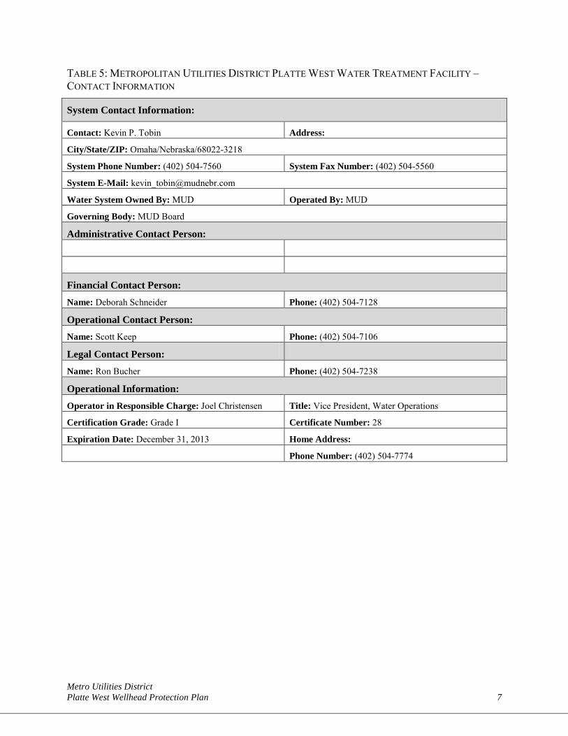
TABLE 5: METROPOLITAN UTILITIES DISTRICT PLATTE WEST WATER TREATMENT FACILITY – CONTACT INFORMATION
System Contact Information:
Contact: Kevin P. Tobin Address:
City/State/ZIP: Omaha/Nebraska/68022-3218
System Phone Number: (402) 504-7560 System Fax Number: (402) 504-5560
System E-Mail: [email protected]
Water System Owned By: MUD Operated By: MUD
Governing Body: MUD Board
Administrative Contact Person:
Financial Contact Person: Name: Deborah Schneider Phone: (402) 504-7128
Operational Contact Person: Name: Scott Keep Phone: (402) 504-7106
Legal Contact Person:
Name: Ron Bucher Phone: (402) 504-7238
Operational Information: Operator in Responsible Charge: Joel Christensen Title: Vice President, Water Operations
Certification Grade: Grade I Certificate Number: 28
Expiration Date: December 31, 2013 Home Address:
Phone Number: (402) 504-7774
Metro Utilities District Platte West Wellhead Protection Plan 8
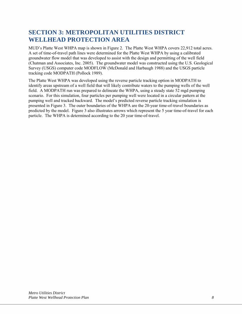
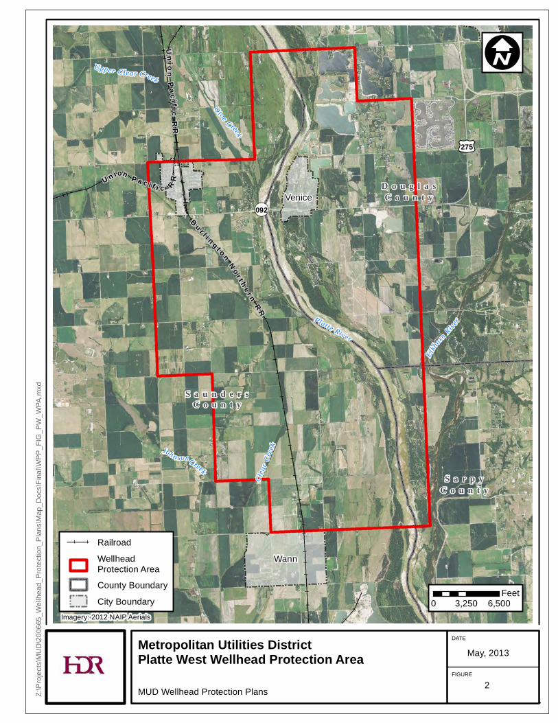
SECTION 3: METROPOLITAN UTILITIES DISTRICT WELLHEAD PROTECTION AREA MUD’s Platte West WHPA map is shown in Figure 2. The Platte West WHPA covers 22,912 total acres. A set of time-of-travel path lines were determined for the Platte West WHPA by using a calibrated groundwater flow model that was developed to assist with the design and permitting of the well field (Chatman and Associates, Inc. 2005). The groundwater model was constructed using the U.S. Geological Survey (USGS) computer code MODFLOW (McDonald and Harbaugh 1988) and the USGS particle tracking code MODPATH (Pollock 1989).
The Platte West WHPA was developed using the reverse particle tracking option in MODPATH to identify areas upstream of a well field that will likely contribute waters to the pumping wells of the well field. A MODPATH run was prepared to delineate the WHPA, using a steady state 52 mgd pumping scenario. For this simulation, four particles per pumping well were located in a circular pattern at the pumping well and tracked backward. The model’s predicted reverse particle tracking simulation is presented in Figure 3. The outer boundaries of the WHPA are the 20-year time-of-travel boundaries as predicted by the model. Figure 3 also illustrates arrows which represent the 5 year time-of-travel for each particle. The WHPA is determined according to the 20 year time-of-travel.
£¤275
¬«092
S a u n d e r sC o u n t y
S a r p yC o u n t y
D o u g l a sC o u n t yVenice
Wann
U n ion P a c i f i c RR
Un ion
P a c if icR
R
B u r l i n g t o nN o r t h e r n
R R
Platte RiverOtoe Creek
Clea
r Cree
kJoh n sonCreek
Upper Clear Creek
Elkhorn
River
Metropolitan Utilities DistrictPlatte West Wellhead Protection Area
MUD Wellhead Protection Plans
DATE
FIGURE
May, 2013
Z:\Pr
ojects
\MUD
\2006
65_W
ellhe
ad_P
rotec
tion_
Plans
\Map
_Doc
s\Fina
l\WPP
_FIG
_PW
_WPA
.mxd
I
0 3,250 6,500Feet
RailroadWellheadProtection AreaCounty BoundaryCity Boundary
Imagery: 2012 NAIP Aerials
2
Metro Utilities District Platte West Wellhead Protection Plan 11
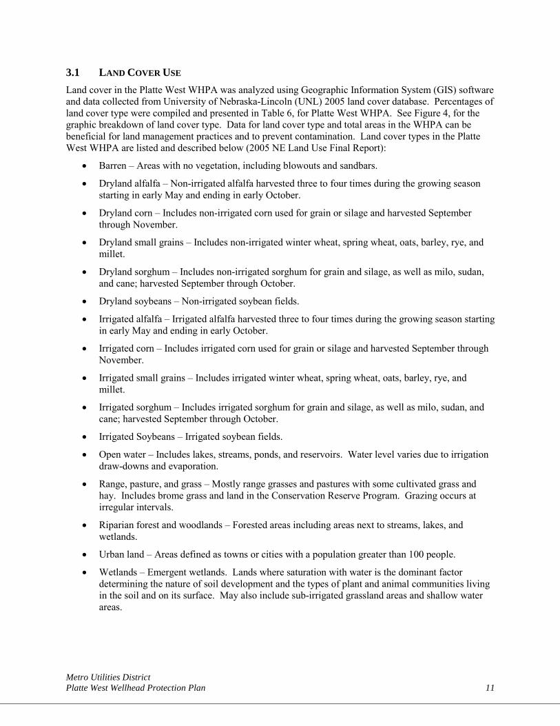
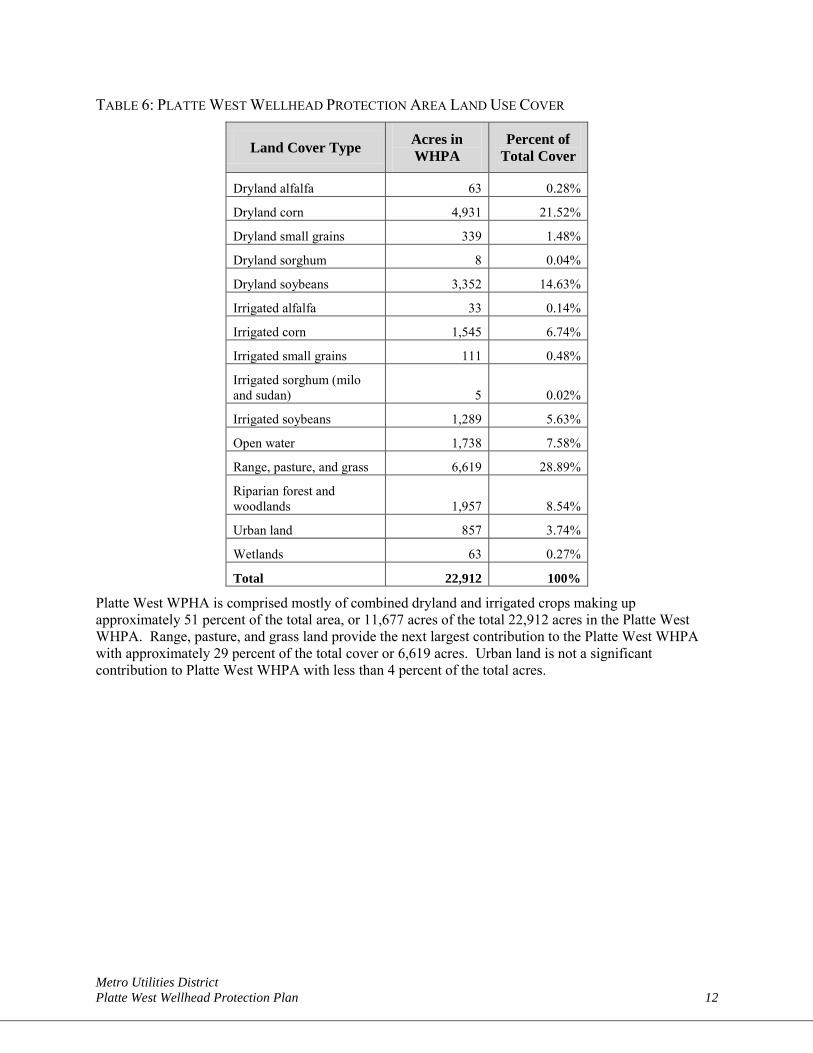
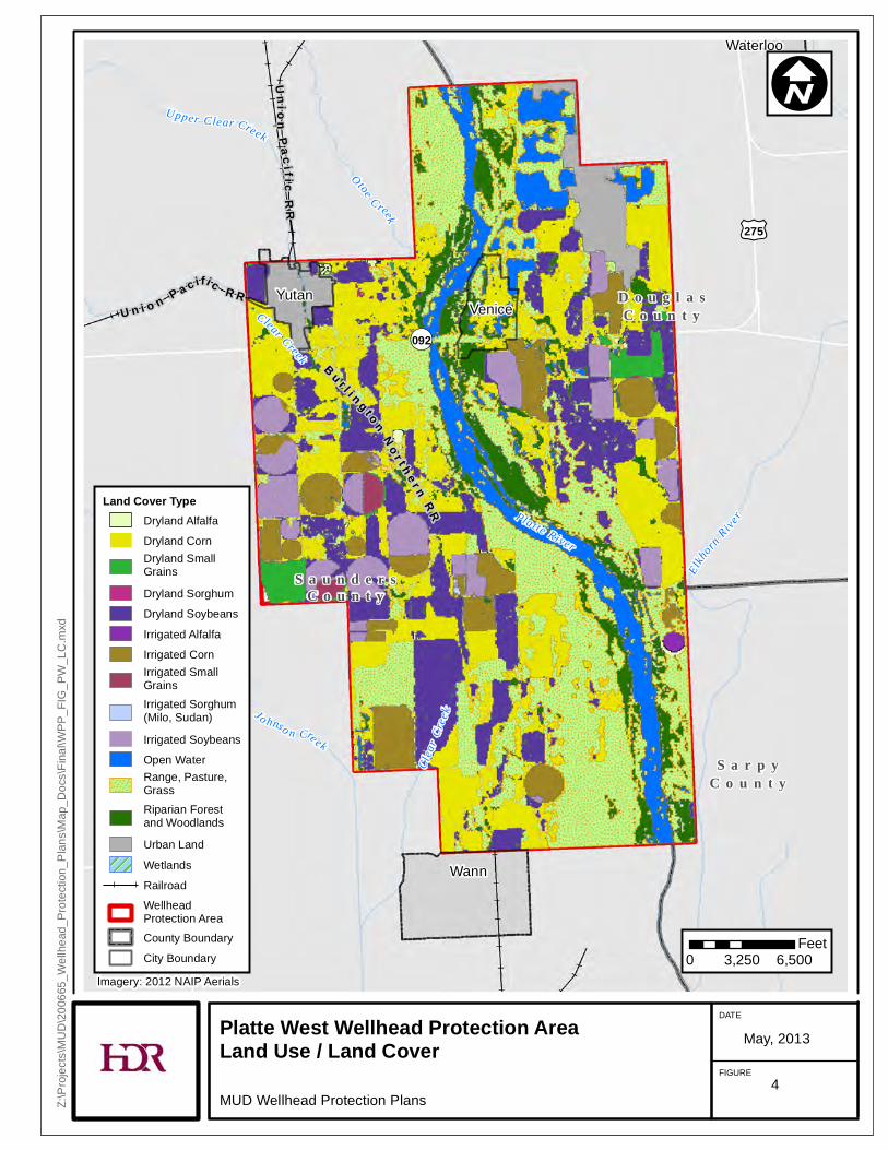
3.1 LAND COVER USE Land cover in the Platte West WHPA was analyzed using Geographic Information System (GIS) software and data collected from University of Nebraska-Lincoln (UNL) 2005 land cover database. Percentages of land cover type were compiled and presented in Table 6, for Platte West WHPA. See Figure 4, for the graphic breakdown of land cover type. Data for land cover type and total areas in the WHPA can be beneficial for land management practices and to prevent contamination. Land cover types in the Platte West WHPA are listed and described below (2005 NE Land Use Final Report):
• Barren – Areas with no vegetation, including blowouts and sandbars.
• Dryland alfalfa – Non-irrigated alfalfa harvested three to four times during the growing season starting in early May and ending in early October.
• Dryland corn – Includes non-irrigated corn used for grain or silage and harvested September through November.
• Dryland small grains – Includes non-irrigated winter wheat, spring wheat, oats, barley, rye, and millet.
• Dryland sorghum – Includes non-irrigated sorghum for grain and silage, as well as milo, sudan, and cane; harvested September through October.
• Dryland soybeans – Non-irrigated soybean fields.
• Irrigated alfalfa – Irrigated alfalfa harvested three to four times during the growing season starting in early May and ending in early October.
• Irrigated corn – Includes irrigated corn used for grain or silage and harvested September through November.
• Irrigated small grains – Includes irrigated winter wheat, spring wheat, oats, barley, rye, and millet.
• Irrigated sorghum – Includes irrigated sorghum for grain and silage, as well as milo, sudan, and cane; harvested September through October.
• Irrigated Soybeans – Irrigated soybean fields.
• Open water – Includes lakes, streams, ponds, and reservoirs. Water level varies due to irrigation draw-downs and evaporation.
• Range, pasture, and grass – Mostly range grasses and pastures with some cultivated grass and hay. Includes brome grass and land in the Conservation Reserve Program. Grazing occurs at irregular intervals.
• Riparian forest and woodlands – Forested areas including areas next to streams, lakes, and wetlands.
• Urban land – Areas defined as towns or cities with a population greater than 100 people.
• Wetlands – Emergent wetlands. Lands where saturation with water is the dominant factor determining the nature of soil development and the types of plant and animal communities living in the soil and on its surface. May also include sub-irrigated grassland areas and shallow water areas.
Metro Utilities District Platte West Wellhead Protection Plan 12
TABLE 6: PLATTE WEST WELLHEAD PROTECTION AREA LAND USE COVER
Land Cover Type Acres in WHPA
Percent of Total Cover
Dryland alfalfa 63 0.28%
Dryland corn 4,931 21.52%
Dryland small grains 339 1.48%
Dryland sorghum 8 0.04%
Dryland soybeans 3,352 14.63%
Irrigated alfalfa 33 0.14%
Irrigated corn 1,545 6.74%
Irrigated small grains 111 0.48%
Irrigated sorghum (milo and sudan) 5 0.02%
Irrigated soybeans 1,289 5.63%
Open water 1,738 7.58%
Range, pasture, and grass 6,619 28.89%
Riparian forest and woodlands 1,957 8.54%
Urban land 857 3.74%
Wetlands 63 0.27%
Total 22,912 100%
Platte West WPHA is comprised mostly of combined dryland and irrigated crops making up approximately 51 percent of the total area, or 11,677 acres of the total 22,912 acres in the Platte West WHPA. Range, pasture, and grass land provide the next largest contribution to the Platte West WHPA with approximately 29 percent of the total cover or 6,619 acres. Urban land is not a significant contribution to Platte West WHPA with less than 4 percent of the total acres.
Waterloo
YutanVenice
Wann
£¤275
¬«092
S a u n d e r sC o u n t y
S a r p yC o u n t y
D o u g l a sC o u n t yU n i o n P a c i f i c R R
UnionP a ci f ic
RR
B u r l i n g t o nNo r t h e r n
RR
Otoe Creek
Clea
r Cree
k
C lear Creek
Jo hnso n Cre ek
Upper Clear Creek
Elkhorn
RiverPlatte River
Platte West Wellhead Protection AreaLand Use / Land CoverMUD Wellhead Protection Plans
DATE
FIGURE
May, 2013
Z:\Pr
ojects
\MUD
\2006
65_W
ellhe
ad_P
rotec
tion_
Plans
\Map
_Doc
s\Fina
l\WPP
_FIG
_PW
_LC.
mxd
I
0 3,250 6,500Feet
Land Cover TypeDryland AlfalfaDryland CornDryland Small GrainsDryland SorghumDryland SoybeansIrrigated AlfalfaIrrigated CornIrrigated Small GrainsIrrigated Sorghum (Milo, Sudan)Irrigated SoybeansOpen WaterRange, Pasture,GrassRiparian Forest and WoodlandsUrban LandWetlandsRailroadWellheadProtection AreaCounty BoundaryCity Boundary
Imagery: 2012 NAIP Aerials
4
Metro Utilities District Platte West Wellhead Protection Plan 14
SECTION 4: POTENTIAL CONTAMINANT SOURCE INVENTORY A contaminant source inventory is provided to compile sources and activities that could potentially contribute to pollution of the groundwater supplies. Databases for each of the potential contaminant sources were mapped using GIS software and aerial photography. Sources obtained include:
• Registered water wells (provided by NDEQ).
• NDEQ regulated facilities.
• Nebraska oil and gas wells from Nebraska Oil and Gas Conservation Commission (NOGCC) database.
• State Fire Marshal database for hazardous sites
• Underground storage tanks (USTs) database (State Fire Marshal database)
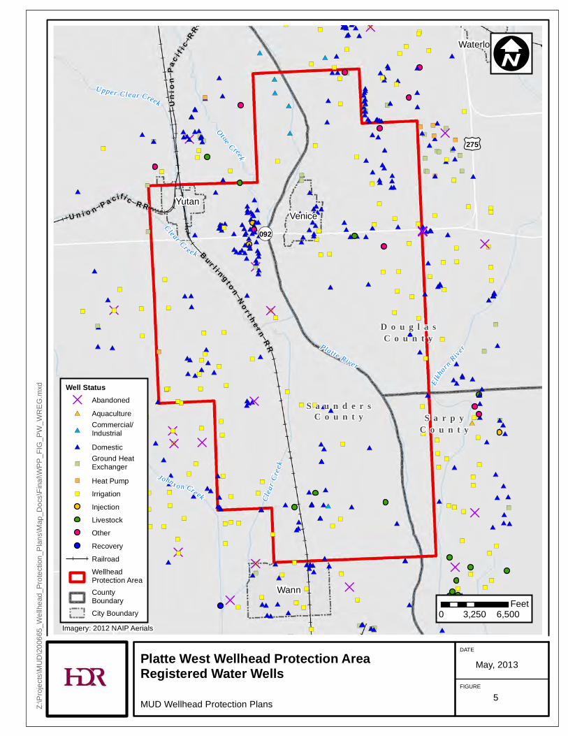
4.1 REGISTERED WATER WELLS Registered water wells located in the Platte West WHPA include commercial and industrial, domestic, irrigation, ground heat exchanger, livestock, heat pump, and abandoned wells. An aquaculture well is also located on the east side of Platte West WHPA. All wells in and around Platte West WHPA are shown in Figure 5.
")
#*
D
#*
")
#*
#*
")
#*
D
")
#*
#*
#*
D
#*
")
#*
#*
D
")
")
#*
#*
#*
")
#*
")
#*
#*
")
")
#*
#*
D#*
#*
#*
#*
#*
#*
#*
#*
")
#*
#*
#*
#*
#*
")
#*
")
#*
#*
")
#*
#* #*
#*
#*
#*
#*
#*
")
#*
#*
")
")
D
#*
#*
D
#*
")
#*
#*#* D
")
")
")
")
")
")
")
")
#*
#*
#*
#*
")
")
")
")
D
")
#*
#*
#*
#*
#*
#*
#*
#*
#*
#*
D
#*
#*
#*
")
#*
")
")
")
#*
")
")
")
#*
#*
#*
")
")
")
")
#*
#*
#*
#*
")
") ")
#*
#*
#*
D")
#*
#*
#*
#*
#*
")
")
#*
#*
#*
")
#*
#*
")
#*
")
#*
#*
#*
#*
")
#*
#*
#*
#*
#*
#*
#*
")
#*
#*
")
")
#*
")
#*
#*
#*
#*
")
")
")
#*
#*
#*
")#*
#*
D
")
")
")
#*
")
")
#*
#*
")
#*
#*
#*
#*")
")
")
")
")
")
#*
#*
#*
")
")
")
")
")
")
")
")
#*
#*
#*
#*
#*
#*
#*
#*
#*
#*
D
#*
#*
#*
#*
")
#*
#*
#*
")
#*
#*
#*
")
#*
#*
#*
")
#*
")
#*
")
#*
")
#*#*#*
#*
")
#*
D
")
#*
")
#*
#*
#*
#*
#*
")
")
#*
#*
")
#*
")
")
")
#*
#*
")
#*
")
#*
#*
#* ")
")
D#*
")
#*
")
")
")
")
")#*
#*
#*
#*
")
#*
#*
#*
#*
")
#*
#*
#*
#*
#*
")
")
")
")
")
")
#*
#*
#*
#*
#*
#*
#*
")
#*
#*
")
#*")
")
#*
#*
#*
#*
#*
#*
")
")
#*
#*
")
")
#*
")
")
")
#*
")
")
#*
")
#* ")
#*
D
D
")
#*
")
#* #*#*
#*
")
#*
#*
#*
#*
")
")
#*
#*
")
#*
#*
#*
#*
")
#*
")
")
#*
#*
")
#*
#*
#*
#*
#*
#*
")
#*
")
#*
")
#*
")
#*
")
")
#*
#*#*
")
#*
#*
#*
")
#*
#*
#*
#*
#*
#*
")
")
#*
")
")
#*
#*
#*
#*
#*
#*#*
")
")
")
#*
")
#*
#*
")
#*
")
D
#*#*
")
#*
#*
#*
#*
#*
#*
#*
")
#*
#*
D
#*
#*
")
#*
")
#*
#*
#*
#*
")
#*
")
#*
")
#*
#*
#*
")
#*
#*
")
#*
")
")
")
#*
#*
")
#*
")
")
")
#*
#*
#*
D
#*
#*
#*
")
")
#*
")
")
")
#*
#*
#*
")
#*
")
")
")
#*
#*
#*
")
#*
#*
")
#*
")
D
#*#*
")
#*
#*
")
#*
#*
D
")
")
#*
D
Waterloo
YutanVenice
Wann
S a u n d e r sC o u n t y S a r p y
C o u n t y
D o u g l a sC o u n t y
£¤275
¬«092U n i o n P a c if i c R R
Unio
nPa
c i f ic
R R
B u r l i n g t o nN o r t h e r n
R R
Clea
r Cree
k
Otoe Creek
Clear Cr eek
J ohns on Creek
Upper Clear Creek
Elkhorn
RiverPlatte River
Platte West Wellhead Protection AreaRegistered Water WellsMUD Wellhead Protection Plans
DATE
FIGURE
May, 2013
Z:\Pr
ojects
\MUD
\2006
65_W
ellhe
ad_P
rotec
tion_
Plans
\Map
_Doc
s\Fina
l\WPP
_FIG
_PW
_WRE
G.mx
d
I
0 3,250 6,500Feet
Well StatusD Abandoned#* Aquaculture#*
Commercial/Industrial
#* Domestic")
Ground Heat Exchanger
") Heat Pump") Irrigation
InjectionLivestockOtherRecoveryRailroadWellheadProtection AreaCounty BoundaryCity Boundary
Imagery: 2012 NAIP Aerials
5
Metro Utilities District Platte West Wellhead Protection Plan 16
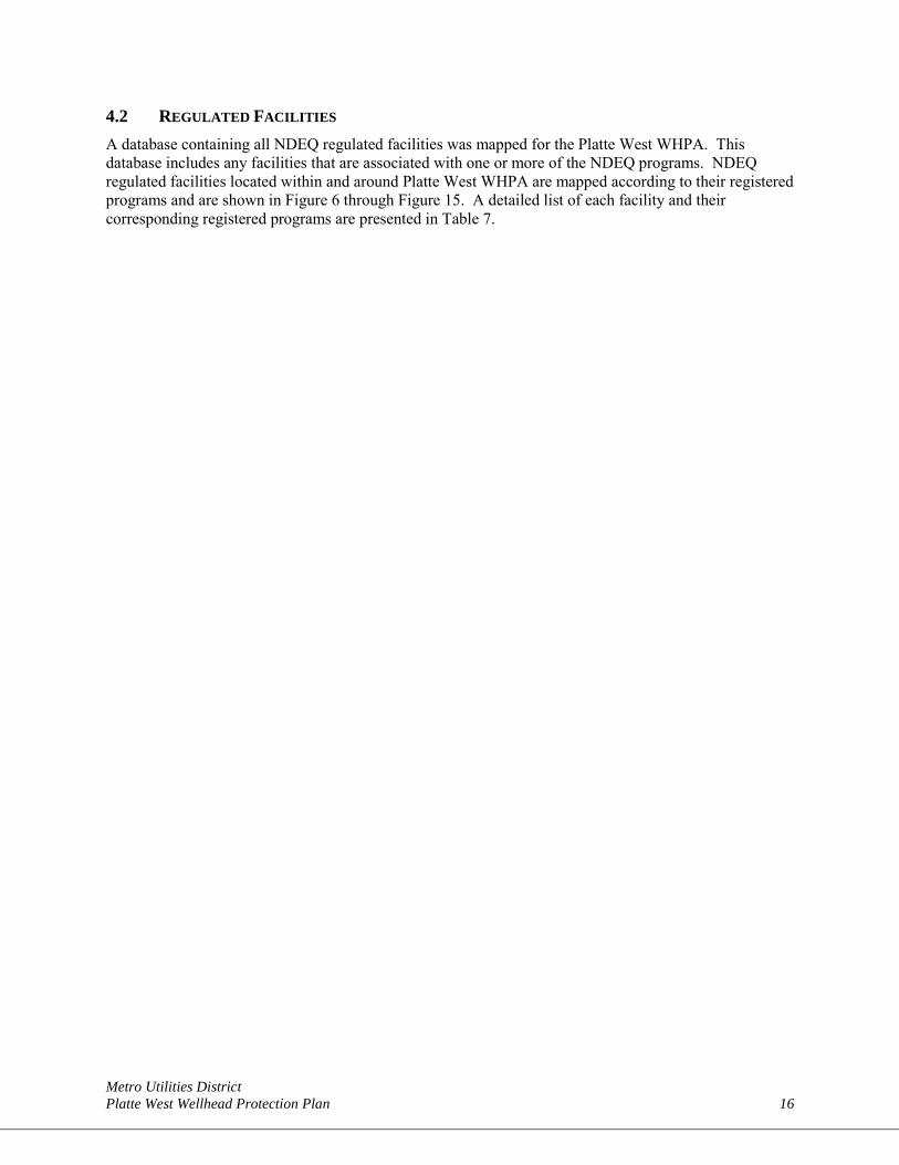
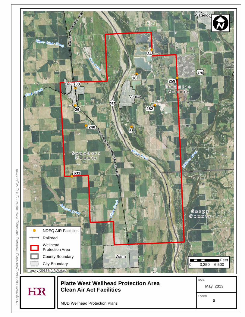
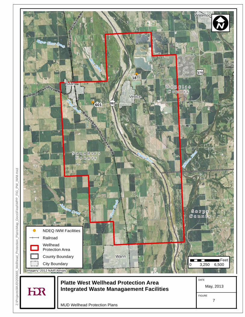
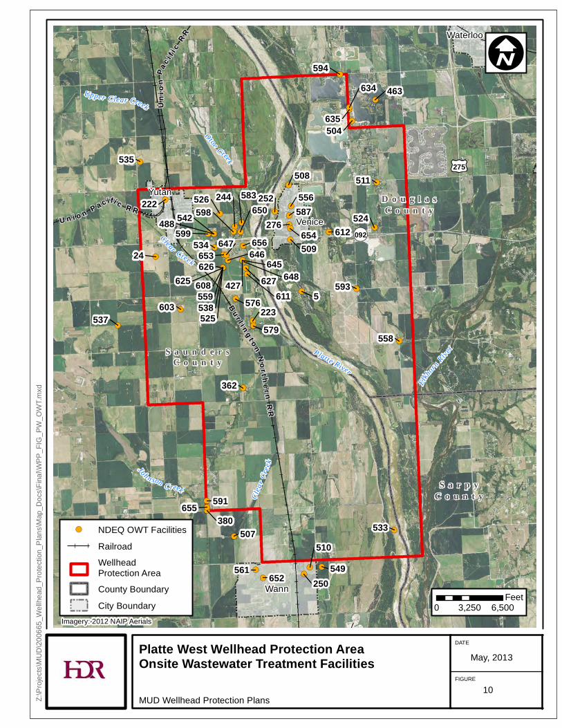
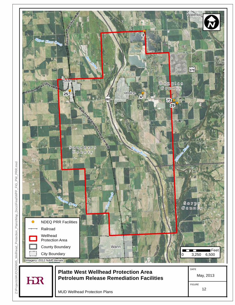
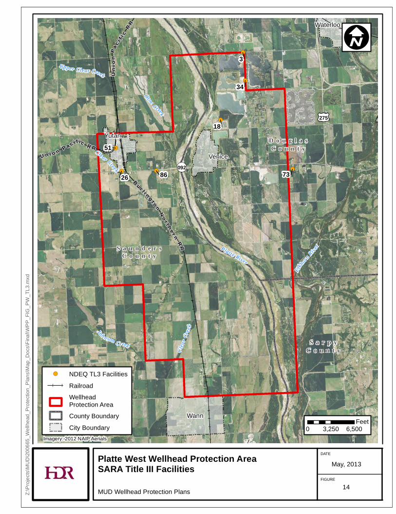
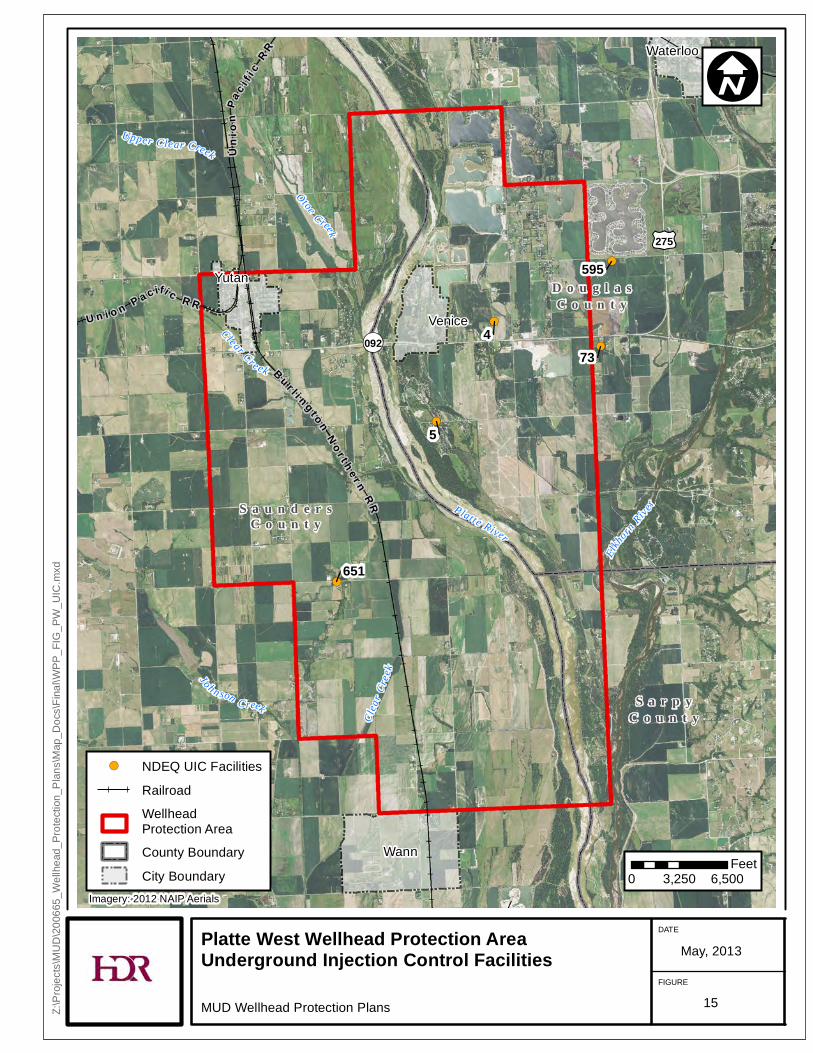
4.2 REGULATED FACILITIES A database containing all NDEQ regulated facilities was mapped for the Platte West WHPA. This database includes any facilities that are associated with one or more of the NDEQ programs. NDEQ regulated facilities located within and around Platte West WHPA are mapped according to their registered programs and are shown in Figure 6 through Figure 15. A detailed list of each facility and their corresponding registered programs are presented in Table 7.
!(
!(
!(
!(
!(
!(
!(
!(
!(
Waterloo
Yutan
Venice
Wann
£¤275
¬«092
S a u n d e r sC o u n t y
S a r p yC o u n t y
D o u g l a sC o u n t y
Uni
onP a
c i f ic
R R
B u r l i n g t o nN o r t h er n
R R
Clea
r Cre
e k
O toe C reek
Clear Creek
Joh n son C reek
Upper Clear Creek
Elkhorn
RiverP lat te River
26
631
34
18
282
38
5
259
240
Platte West Wellhead Protection AreaClean Air Act FacilitiesMUD Wellhead Protection Plans
DATE
FIGURE
May, 2013
Z:\Pr
ojects
\MUD
\2006
65_W
ellhe
ad_P
rotec
tion_
Plans
\Map
_Doc
s\Fina
l\WPP
_FIG
_PW
_AIR
.mxd
I
0 3,250 6,500Feet
!( NDEQ AIR FacilitiesRailroadWellheadProtection AreaCounty BoundaryCity Boundary
Imagery: 2012 NAIP Aerials
6
!(
!(
Waterloo
Yutan
Venice
Wann
£¤275
¬«092
S a u n d e r sC o u n t y
S a r p yC o u n t y
D o u g l a sC o u n t y
U n i o n P a c ifi c R R
Uni
onPa
c i f ic
R R
B u r l i n g t o nN o r t h e r n
R R
Clea
r Cre
e k
Otoe C reek
Clear Cre ek
Joh n son C reek
Upper Clear Creek
Elkhorn
RiverPlatte River
601
18
Platte West Wellhead Protection AreaIntegrated Waste Managaement Facilities
MUD Wellhead Protection Plans
DATE
FIGURE
May, 2013
Z:\Pr
ojects
\MUD
\2006
65_W
ellhe
ad_P
rotec
tion_
Plans
\Map
_Doc
s\Fina
l\WPP
_FIG
_PW
_IWM.
mxd
I
0 3,250 6,500Feet
!( NDEQ IWM FacilitiesRailroadWellheadProtection AreaCounty BoundaryCity Boundary
Imagery: 2012 NAIP Aerials
7

!(!(
!(!(
!(
!(
!(
!(
Waterloo
Yutan
Venice
Wann
£¤275
¬«092
S a u n d e r sC o u n t y
S a r p yC o u n t y
D o u g l a sC o u n t y
U n i o n P a c i f ic R R
Uni
onPa
c i f ic
R R
B u r l i n g t o nN o r t h e r n
R R
Clea
r Cre
e k
Otoe C reek
Joh n son C reek
Upper Clear Creek
Elkhorn
RiverPlatte River
7326
267 3
29
2598025
Platte West Wellhead Protection AreaLeaking Storage Tank Facilities
MUD Wellhead Protection Plans
DATE
FIGURE
May, 2013
Z:\Pr
ojects
\MUD
\2006
65_W
ellhe
ad_P
rotec
tion_
Plans
\Map
_Doc
s\Fina
l\WPP
_FIG
_PW
_LST
.mxd
I
0 3,250 6,500Feet
!( NDEQ LST FacilitiesRailroadWellheadProtection AreaCounty BoundaryCity Boundary
Imagery: 2012 NAIP Aerials
8
!(
!(
!(
!(
!(
!(
!(
!(
!(
!(
!(
!(
!(
!(
!(
!(!(
!(
!(
!(
!(
!(
!(
!(
!(
!(
!(
!(
Waterloo
Yutan
Venice
Wann
£¤275
¬«092
S a u n d e r sC o u n t y
S a r p yC o u n t y
D o u g l a sC o u n t y
U n i o n P a c i f ic R R
Unio
nPa
c i f ic
R R
Bu rl i n gt on
No r t h e r nR
R
Clea
r Cre
e k
Ot o e Cre ek
C lear Creek
Joh n son C reek
Upper Clear Creek
Elkhorn
RiverPlatte River
342
361
379
257
377
255
287
292
355
358
286
285
256
441
261
363360
364
362
282
365
339
301
366
262
357359
338
Platte West Wellhead Protection AreaLivestock Waste Control FacilitiesMUD Wellhead Protection Plans
DATE
FIGURE
May, 2013
Z:\Pr
ojects
\MUD
\2006
65_W
ellhe
ad_P
rotec
tion_
Plans
\Map
_Doc
s\Fina
l\WPP
_FIG
_PW
_LWC
.mxd
I
0 3,250 6,500Feet
!( NDEQ LWC FacilitiesRailroadWellheadProtection AreaCounty BoundaryCity Boundary
Imagery: 2012 NAIP Aerials
9
!(
!(
!(
!(
!(
!(
!(
!(
!(!(
!(
!(
!(
!(
!(
!(
!(
!(
!(
!(!(
!(
!(
!(
!(
!(
!(!(
!(
!(
!(
!(
!(
!(
!(
!(!(
!(!(
!(
!(
!(
!(
!(
!(
!(
!(
!(
!(
!(!(
!(
!(
!(
!(
!(
!(
!(
!(
!(
!(
!(
Waterloo
Yutan
Venice
Wann
533
463
535
593
537
612
549
594
524
558
603
362
511
591
561
654
579
583
647
655
222
5
508
599
652
24
634
534 656
223
653
250
625
635
626
252
380
526587
488598
646645
648
542
611608
510
650
538
509
627
507
276
427
525576
556244
504
559
£¤275
¬«092
S a u n d e r sC o u n t y
S a r p yC o u n t y
D o u g l a sC o u n t y
U n i o n P a c ifi c R R
Uni
onPa
c i f ic
R R
B u r l i n g t o nNo rt he r n
R R
Clea
r Cre
e k
Otoe C reek
Clear Creek
Joh n son C reek
Upper Clear Creek
Elkhorn
RiverPlatte River
Platte West Wellhead Protection AreaOnsite Wastewater Treatment Facilities
MUD Wellhead Protection Plans
DATE
FIGURE
May, 2013
Z:\Pr
ojects
\MUD
\2006
65_W
ellhe
ad_P
rotec
tion_
Plans
\Map
_Doc
s\Fina
l\WPP
_FIG
_PW
_OWT
.mxd
I
0 3,250 6,500Feet
!( NDEQ OWT FacilitiesRailroadWellheadProtection AreaCounty BoundaryCity Boundary
Imagery: 2012 NAIP Aerials
10

!(
!(
!(
!(
!( !(
!(
!(
!(
!(
!(
!(
!(
!(
Waterloo
Yutan
Venice
Wann
£¤275
¬«092
S a u n d e r sC o u n t y
S a r p yC o u n t y
D o u g l a sC o u n t y
U n i o n P a c i f i c R R
Uni
onP a
c i f ic
R R
B u r l i n g t o nN o r t h er n
R R
Clea
r Cre
e k
O toe C reek
C lear Creek
Joh n son C reek
Upper Clear Creek
Elkhorn
RiverP lat te River
289
427
474
267
605606
34
18
29
478
574
464
259
240
Platte West Wellhead Protection AreaNPDES Permits and Compliance Facilities
MUD Wellhead Protection Plans
DATE
FIGURE
May, 2013
Z:\Pr
ojects
\MUD
\2006
65_W
ellhe
ad_P
rotec
tion_
Plans
\Map
_Doc
s\Fina
l\WPP
_FIG
_PW
_PCS
.mxd
I
0 3,250 6,500Feet
!( NDEQ PCS FacilitiesRailroadWellheadProtection AreaCounty BoundaryCity Boundary
Imagery: 2012 NAIP Aerials
11
!(
!(
!(
!(
!(
Waterloo
Yutan
Venice
Wann
£¤275
¬«092
S a u n d e r sC o u n t y
S a r p yC o u n t y
D o u g l a sC o u n t y
U n i o n P a c ifi c R R
Uni
onPa
c i f ic
R R
B u r l i n g t o nN o r t h e r n
R R
Clea
r Cre
e k
Otoe C reek
Joh n son C reek
Upper Clear Creek
Elkhorn
RiverPlatte River
73
3
429
25
Platte West Wellhead Protection AreaPetroleum Release Remediation Facilities
MUD Wellhead Protection Plans
DATE
FIGURE
May, 2013
Z:\Pr
ojects
\MUD
\2006
65_W
ellhe
ad_P
rotec
tion_
Plans
\Map
_Doc
s\Fina
l\WPP
_FIG
_PW
_PRR
.mxd
I
0 3,250 6,500Feet
!( NDEQ PRR FacilitiesRailroadWellheadProtection AreaCounty BoundaryCity Boundary
Imagery: 2012 NAIP Aerials
12

!(
!(
!(
!(
Waterloo
Yutan
Venice
Wann
£¤275
¬«092
S a u n d e r sC o u n t y
S a r p yC o u n t y
D o u g l a sC o u n t y
U n i o n P a c ifi c R R
Uni
onPa
c i f ic
R R
B u r l i n g t o nN o r t h e r n
R R
Clea
r Cre
e k
Otoe C reek
Clear Cre ek
Joh n son C reek
Upper Clear Creek
Elkhorn
RiverPlatte River
450
34
18
422
Platte West Wellhead Protection AreaRelease Assessment FacilitiesMUD Wellhead Protection Plans
DATE
FIGURE
May, 2013
Z:\Pr
ojects
\MUD
\2006
65_W
ellhe
ad_P
rotec
tion_
Plans
\Map
_Doc
s\Fina
l\WPP
_FIG
_PW
_RA.
mxd
I
0 3,250 6,500Feet
!( NDEQ RA FacilitiesRailroadWellheadProtection AreaCounty BoundaryCity Boundary
Imagery: 2012 NAIP Aerials
13
!(!(
!(
!(
!(
!(
!(
Waterloo
Yutan
Venice
Wann
£¤275
¬«092
S a u n d e r sC o u n t y
S a r p yC o u n t y
D o u g l a sC o u n t y
U n i o n P a c i f ic R R
Uni
onPa
c i f ic
R R
B u r l i n g t o nN o r t h e r n
R R
Clea
r Cre
e k
Otoe C reek
Clear Creek
Joh n son C reek
Upper Clear Creek
Elkhorn
RiverPlatte River
7326
34
18
3
86
51
Platte West Wellhead Protection AreaSARA Title III Facilities
MUD Wellhead Protection Plans
DATE
FIGURE
May, 2013
Z:\Pr
ojects
\MUD
\2006
65_W
ellhe
ad_P
rotec
tion_
Plans
\Map
_Doc
s\Fina
l\WPP
_FIG
_PW
_TL3
.mxd
I
0 3,250 6,500Feet
!( NDEQ TL3 FacilitiesRailroadWellheadProtection AreaCounty BoundaryCity Boundary
Imagery: 2012 NAIP Aerials
14
!(
!(
!(
!(
!(
Waterloo
Yutan
Venice
Wann
£¤275
¬«092
S a u n d e r sC o u n t y
S a r p yC o u n t y
D o u g l a sC o u n t y
U n i o n P a c ifi c R R
Uni
onPa
c i f ic
R R
B u r l i n g t o nN o r t h e r n
R R
Clea
r Cre
e k
Otoe C reek
Clear Cre ek
Joh n son C reek
Upper Clear Creek
Elkhorn
RiverPlatte River
73
595
4
651
5
Platte West Wellhead Protection AreaUnderground Injection Control Facilities
MUD Wellhead Protection Plans
DATE
FIGURE
May, 2013
Z:\Pr
ojects
\MUD
\2006
65_W
ellhe
ad_P
rotec
tion_
Plans
\Map
_Doc
s\Fina
l\WPP
_FIG
_PW
_UIC
.mxd
I
0 3,250 6,500Feet
!( NDEQ UIC FacilitiesRailroadWellheadProtection AreaCounty BoundaryCity Boundary
Imagery: 2012 NAIP Aerials
15
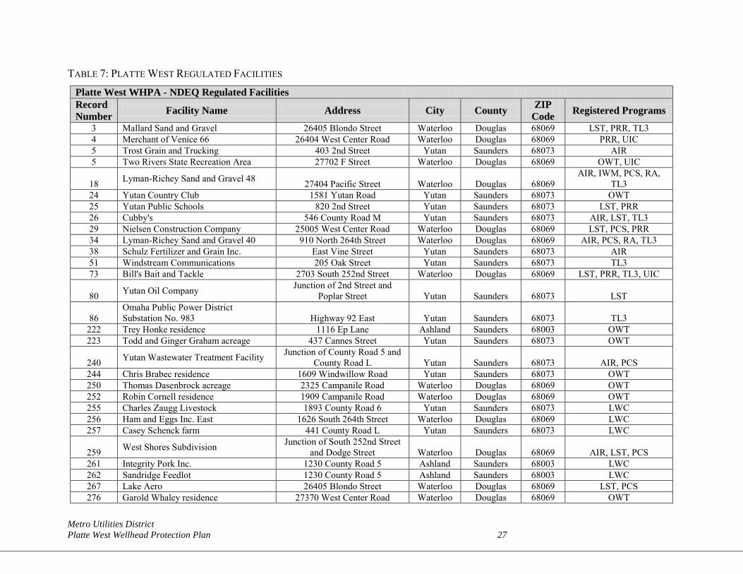
Metro Utilities District Platte West Wellhead Protection Plan 27
TABLE 7: PLATTE WEST REGULATED FACILITIES Platte West WHPA - NDEQ Regulated Facilities Record Number Facility Name Address City County ZIP
Code Registered Programs
3 Mallard Sand and Gravel 26405 Blondo Street Waterloo Douglas 68069 LST, PRR, TL3 4 Merchant of Venice 66 26404 West Center Road Waterloo Douglas 68069 PRR, UIC 5 Trost Grain and Trucking 403 2nd Street Yutan Saunders 68073 AIR 5 Two Rivers State Recreation Area 27702 F Street Waterloo Douglas 68069 OWT, UIC
18 Lyman-Richey Sand and Gravel 48 27404 Pacific Street Waterloo Douglas 68069 AIR, IWM, PCS, RA,
TL3 24 Yutan Country Club 1581 Yutan Road Yutan Saunders 68073 OWT 25 Yutan Public Schools 820 2nd Street Yutan Saunders 68073 LST, PRR 26 Cubby's 546 County Road M Yutan Saunders 68073 AIR, LST, TL3 29 Nielsen Construction Company 25005 West Center Road Waterloo Douglas 68069 LST, PCS, PRR 34 Lyman-Richey Sand and Gravel 40 910 North 264th Street Waterloo Douglas 68069 AIR, PCS, RA, TL3 38 Schulz Fertilizer and Grain Inc. East Vine Street Yutan Saunders 68073 AIR 51 Windstream Communications 205 Oak Street Yutan Saunders 68073 TL3 73 Bill's Bait and Tackle 2703 South 252nd Street Waterloo Douglas 68069 LST, PRR, TL3, UIC
80 Yutan Oil Company Junction of 2nd Street and Poplar Street Yutan Saunders 68073 LST
86 Omaha Public Power District Substation No. 983 Highway 92 East Yutan Saunders 68073 TL3
222 Trey Honke residence 1116 Ep Lane Ashland Saunders 68003 OWT 223 Todd and Ginger Graham acreage 437 Cannes Street Yutan Saunders 68073 OWT
240 Yutan Wastewater Treatment Facility Junction of County Road 5 and County Road L Yutan Saunders 68073 AIR, PCS
244 Chris Brabec residence 1609 Windwillow Road Yutan Saunders 68073 OWT 250 Thomas Dasenbrock acreage 2325 Campanile Road Waterloo Douglas 68069 OWT 252 Robin Cornell residence 1909 Campanile Road Waterloo Douglas 68069 OWT 255 Charles Zaugg Livestock 1893 County Road 6 Yutan Saunders 68073 LWC 256 Ham and Eggs Inc. East 1626 South 264th Street Waterloo Douglas 68069 LWC 257 Casey Schenck farm 441 County Road L Yutan Saunders 68073 LWC
259 West Shores Subdivision Junction of South 252nd Street and Dodge Street Waterloo Douglas 68069 AIR, LST, PCS
261 Integrity Pork Inc. 1230 County Road 5 Ashland Saunders 68003 LWC 262 Sandridge Feedlot 1230 County Road 5 Ashland Saunders 68003 LWC 267 Lake Aero 26405 Blondo Street Waterloo Douglas 68069 LST, PCS 276 Garold Whaley residence 27370 West Center Road Waterloo Douglas 68069 OWT
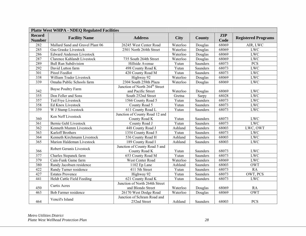
Metro Utilities District Platte West Wellhead Protection Plan 28
Platte West WHPA - NDEQ Regulated Facilities Record Number Facility Name Address City County ZIP
Code Registered Programs
282 Mallard Sand and Gravel Plant 06 26245 West Center Road Waterloo Douglas 68069 AIR, LWC 285 Gus Graske Livestock 2501 North 264th Street Waterloo Douglas 68069 LWC 286 Edward Andersen Livestock Waterloo Douglas 68069 LWC 287 Clarence Kahlandt Livestock 735 South 264th Street Waterloo Douglas 68069 LWC 289 Bull Run Subdivision Hillside Avenue Yutan Saunders 68073 PCS 292 David Lutton farm 498 County Road K Yutan Saunders 68073 LWC 301 Pitzel Feedlot 420 County Road M Yutan Saunders 68073 LWC 338 William Trader Livestock Highway 92 Waterloo Douglas 68069 LWC 339 Omaha Public Schools farm 2304 South 258th Plaza Waterloo Douglas 68069 LWC
342 Bayse Poultry Farm Junction of North 264th Street and Pacific Street Waterloo Douglas 68069 LWC
355 Don Feller and Sons South 252nd Street Gretna Sarpy 68028 LWC 357 Ted Frye Livestock 1566 County Road 5 Yutan Saunders 68073 LWC 358 Ed Knox Livestock County Road 5 Yutan Saunders 68073 LWC 359 W J Stamp Livestock 611 County Road L Yutan Saunders 68073 LWC
360 Ken Neff Livestock Junction of County Road 12 and County Road K Yutan Saunders 68073 LWC
361 Bernie Gehl Livestock County Road J Yutan Saunders 68073 LWC 362 Kenneth Mumm Livestock 448 County Road J Ashland Saunders 68003 LWC, OWT 363 Karloff Brothers 1354 County Road 5 Yutan Saunders 68073 LWC 364 Kenneth Kirchmann Livestock 536 County Road H Ashland Saunders 68003 LWC 365 Marion Haldeman Livestock 189 County Road I Ashland Saunders 68003 LWC
366 Robert Geranis Livestock Junction of County Road 5 and County Road K Yutan Saunders 68073 LWC
377 Charles Stepanek farm 653 County Road M Yutan Saunders 68073 LWC 379 Cain-Funk Game farm West Center Road Waterloo Saunders 68069 LWC 380 Randy Jacobsen residence 1102 Ep Lane Ashland Saunders 68003 OWT 422 Randy Turner residence 411 5th Street Yutan Saunders 68073 RA 427 Estates Provence Highway 92 Yutan Saunders 68073 OWT, PCS 441 Heldt Cattle Field Feeding 621 County Road K Yutan Saunders 68073 LWC
450 Curtis Acres Junction of North 264th Street and Blondo Street Waterloo Douglas 68069 RA
463 Bob Farmer residence 26170 West Dodge Road Waterloo Douglas 68069 OWT
464 Vencil's Island Junction of Schram Road and 252nd Street Ashland Saunders 68003 PCS
Metro Utilities District Platte West Wellhead Protection Plan 29
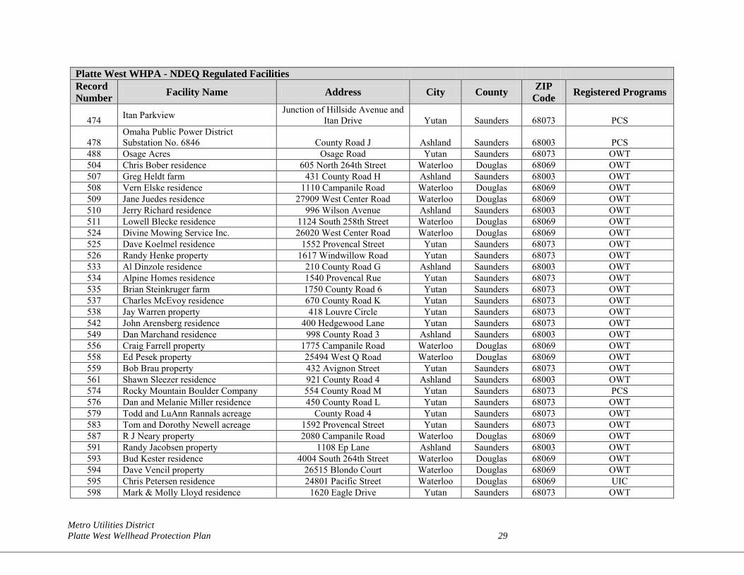
Platte West WHPA - NDEQ Regulated Facilities Record Number Facility Name Address City County ZIP
Code Registered Programs
474 Itan Parkview Junction of Hillside Avenue and Itan Drive Yutan Saunders 68073 PCS
478 Omaha Public Power District Substation No. 6846 County Road J Ashland Saunders 68003 PCS
488 Osage Acres Osage Road Yutan Saunders 68073 OWT 504 Chris Bober residence 605 North 264th Street Waterloo Douglas 68069 OWT 507 Greg Heldt farm 431 County Road H Ashland Saunders 68003 OWT 508 Vern Elske residence 1110 Campanile Road Waterloo Douglas 68069 OWT 509 Jane Juedes residence 27909 West Center Road Waterloo Douglas 68069 OWT 510 Jerry Richard residence 996 Wilson Avenue Ashland Saunders 68003 OWT 511 Lowell Blecke residence 1124 South 258th Street Waterloo Douglas 68069 OWT 524 Divine Mowing Service Inc. 26020 West Center Road Waterloo Douglas 68069 OWT 525 Dave Koelmel residence 1552 Provencal Street Yutan Saunders 68073 OWT 526 Randy Henke property 1617 Windwillow Road Yutan Saunders 68073 OWT 533 Al Dinzole residence 210 County Road G Ashland Saunders 68003 OWT 534 Alpine Homes residence 1540 Provencal Rue Yutan Saunders 68073 OWT 535 Brian Steinkruger farm 1750 County Road 6 Yutan Saunders 68073 OWT 537 Charles McEvoy residence 670 County Road K Yutan Saunders 68073 OWT 538 Jay Warren property 418 Louvre Circle Yutan Saunders 68073 OWT 542 John Arensberg residence 400 Hedgewood Lane Yutan Saunders 68073 OWT 549 Dan Marchand residence 998 County Road 3 Ashland Saunders 68003 OWT 556 Craig Farrell property 1775 Campanile Road Waterloo Douglas 68069 OWT 558 Ed Pesek property 25494 West Q Road Waterloo Douglas 68069 OWT 559 Bob Brau property 432 Avignon Street Yutan Saunders 68073 OWT 561 Shawn Sleezer residence 921 County Road 4 Ashland Saunders 68003 OWT 574 Rocky Mountain Boulder Company 554 County Road M Yutan Saunders 68073 PCS 576 Dan and Melanie Miller residence 450 County Road L Yutan Saunders 68073 OWT 579 Todd and LuAnn Rannals acreage County Road 4 Yutan Saunders 68073 OWT 583 Tom and Dorothy Newell acreage 1592 Provencal Street Yutan Saunders 68073 OWT 587 R J Neary property 2080 Campanile Road Waterloo Douglas 68069 OWT 591 Randy Jacobsen property 1108 Ep Lane Ashland Saunders 68003 OWT 593 Bud Kester residence 4004 South 264th Street Waterloo Douglas 68069 OWT 594 Dave Vencil property 26515 Blondo Court Waterloo Douglas 68069 OWT 595 Chris Petersen residence 24801 Pacific Street Waterloo Douglas 68069 UIC 598 Mark & Molly Lloyd residence 1620 Eagle Drive Yutan Saunders 68073 OWT
Metro Utilities District Platte West Wellhead Protection Plan 30
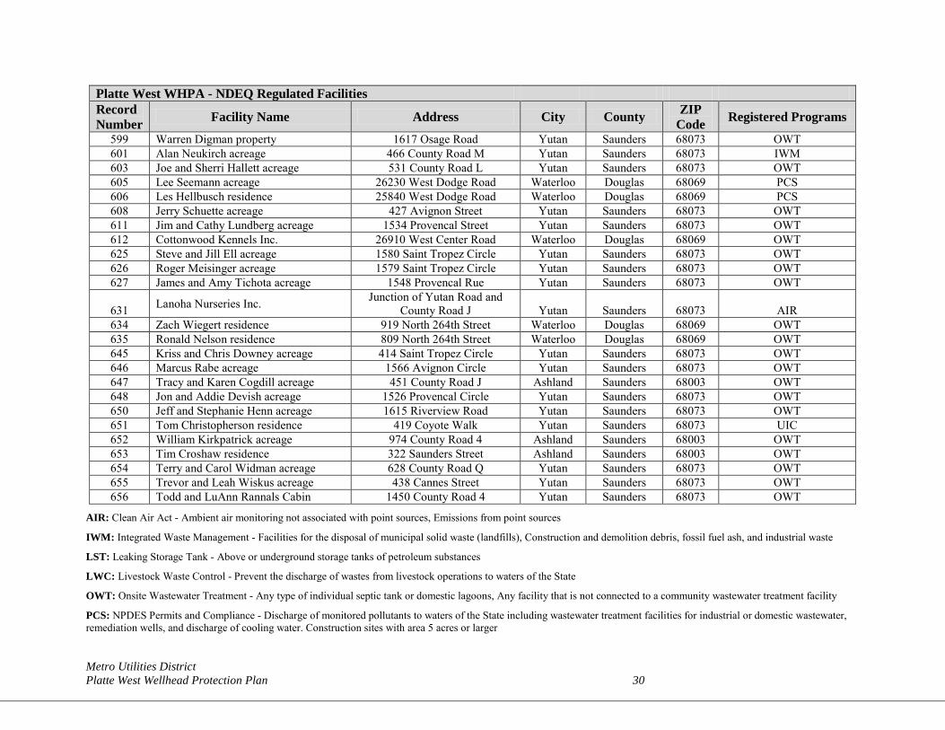
Platte West WHPA - NDEQ Regulated Facilities Record Number Facility Name Address City County ZIP
Code Registered Programs
599 Warren Digman property 1617 Osage Road Yutan Saunders 68073 OWT 601 Alan Neukirch acreage 466 County Road M Yutan Saunders 68073 IWM 603 Joe and Sherri Hallett acreage 531 County Road L Yutan Saunders 68073 OWT 605 Lee Seemann acreage 26230 West Dodge Road Waterloo Douglas 68069 PCS 606 Les Hellbusch residence 25840 West Dodge Road Waterloo Douglas 68069 PCS 608 Jerry Schuette acreage 427 Avignon Street Yutan Saunders 68073 OWT 611 Jim and Cathy Lundberg acreage 1534 Provencal Street Yutan Saunders 68073 OWT 612 Cottonwood Kennels Inc. 26910 West Center Road Waterloo Douglas 68069 OWT 625 Steve and Jill Ell acreage 1580 Saint Tropez Circle Yutan Saunders 68073 OWT 626 Roger Meisinger acreage 1579 Saint Tropez Circle Yutan Saunders 68073 OWT 627 James and Amy Tichota acreage 1548 Provencal Rue Yutan Saunders 68073 OWT
631 Lanoha Nurseries Inc. Junction of Yutan Road and County Road J Yutan Saunders 68073 AIR
634 Zach Wiegert residence 919 North 264th Street Waterloo Douglas 68069 OWT 635 Ronald Nelson residence 809 North 264th Street Waterloo Douglas 68069 OWT 645 Kriss and Chris Downey acreage 414 Saint Tropez Circle Yutan Saunders 68073 OWT 646 Marcus Rabe acreage 1566 Avignon Circle Yutan Saunders 68073 OWT 647 Tracy and Karen Cogdill acreage 451 County Road J Ashland Saunders 68003 OWT 648 Jon and Addie Devish acreage 1526 Provencal Circle Yutan Saunders 68073 OWT 650 Jeff and Stephanie Henn acreage 1615 Riverview Road Yutan Saunders 68073 OWT 651 Tom Christopherson residence 419 Coyote Walk Yutan Saunders 68073 UIC 652 William Kirkpatrick acreage 974 County Road 4 Ashland Saunders 68003 OWT 653 Tim Croshaw residence 322 Saunders Street Ashland Saunders 68003 OWT 654 Terry and Carol Widman acreage 628 County Road Q Yutan Saunders 68073 OWT 655 Trevor and Leah Wiskus acreage 438 Cannes Street Yutan Saunders 68073 OWT 656 Todd and LuAnn Rannals Cabin 1450 County Road 4 Yutan Saunders 68073 OWT
AIR: Clean Air Act - Ambient air monitoring not associated with point sources, Emissions from point sources
IWM: Integrated Waste Management - Facilities for the disposal of municipal solid waste (landfills), Construction and demolition debris, fossil fuel ash, and industrial waste
LST: Leaking Storage Tank - Above or underground storage tanks of petroleum substances
LWC: Livestock Waste Control - Prevent the discharge of wastes from livestock operations to waters of the State
OWT: Onsite Wastewater Treatment - Any type of individual septic tank or domestic lagoons, Any facility that is not connected to a community wastewater treatment facility
PCS: NPDES Permits and Compliance - Discharge of monitored pollutants to waters of the State including wastewater treatment facilities for industrial or domestic wastewater, remediation wells, and discharge of cooling water. Construction sites with area 5 acres or larger
Metro Utilities District Platte West Wellhead Protection Plan 31
PRR: Petroleum Release Remediation - Petroleum release sites eligible for Title 200 reimbursement funds
RA: Release Assessment - Notification of spills, leaks, and other environmental emergencies to provide technical assistance and regulatory oversight to those that pose an immediate hazard to either the environment or public health
TL3: SARA Title III - Voluntary reporting of hazardous chemical storage
UIC: Underground Injection Control - Septic tanks that handle things other than domestic waste (shop drains) or that are large capacity. Injection or discharge of monitored fluids into a well, including non-domestic wastewater and open loop heat pumps
Metro Utilities District Platte West Wellhead Protection Plan 32
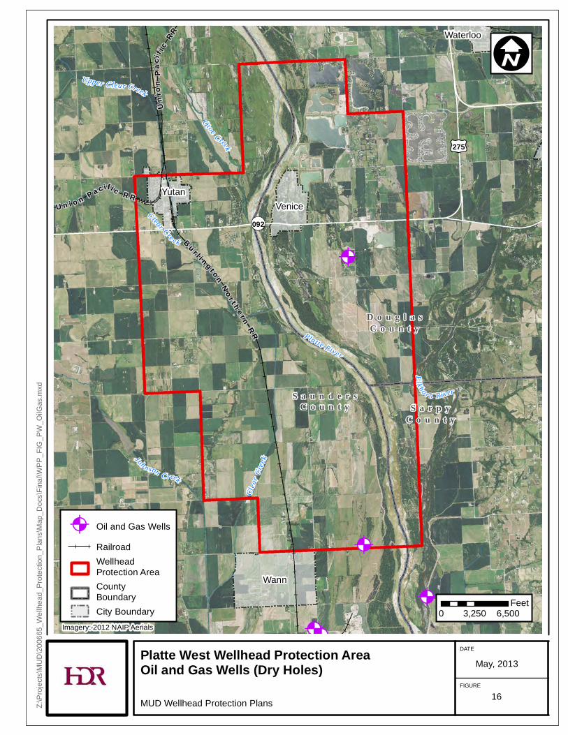
4.3 OIL AND GAS WELLS Oil and gas well data obtained from NOGCC database for Platte West WHPA is shown in Figure 16. Two dry holes were located within Platte West WHPA. These dry holes designate borings and not operational oil and gas wells.
@A@A
@A
@A
@A
@A
@A
@A
Waterloo
YutanVenice
Wann
S a u n d e r sC o u n t y S a r p y
C o u n t y
D o u g l a sC o u n t y
£¤275
¬«092U n i o n P a c i fi c R R
Uni
onPa
cif i c
R R
B u r l i n g t o nN o r t h e r n
R R
Clea
r Cree
k
Otoe Creek
Clear Cre ek
Joh n son C reek
Upper Clear Creek
El k ho r n River
Platte River
Platte West Wellhead Protection Area Oil and Gas Wells (Dry Holes)
MUD Wellhead Protection Plans
DATE
FIGURE
May, 2013
Z:\Pr
ojects
\MUD
\2006
65_W
ellhe
ad_P
rotec
tion_
Plans
\Map
_Doc
s\Fina
l\WPP
_FIG
_PW
_OilG
as.m
xd
I
0 3,250 6,500Feet
@A Oil and Gas WellsRailroadWellheadProtection AreaCounty BoundaryCity Boundary
Imagery: 2012 NAIP Aerials
16
Metro Utilities District Platte West Wellhead Protection Plan 34
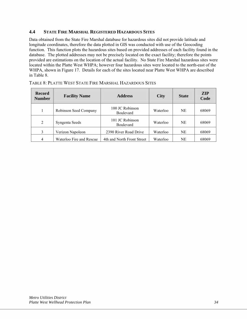
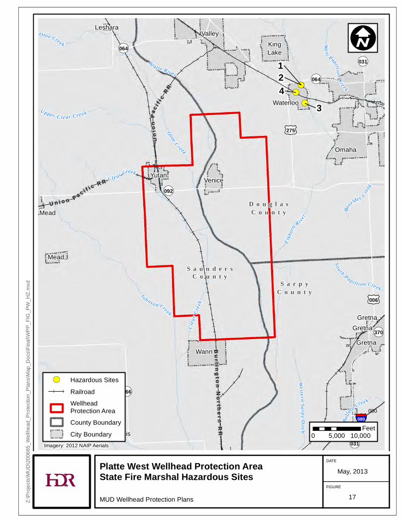
4.4 STATE FIRE MARSHAL REGISTERED HAZARDOUS SITES Data obtained from the State Fire Marshal database for hazardous sites did not provide latitude and longitude coordinates, therefore the data plotted in GIS was conducted with use of the Geocoding function. This function plots the hazardous sites based on provided addresses of each facility found in the database. The plotted addresses may not be precisely located on the exact facility; therefore the points provided are estimations on the location of the actual facility. No State Fire Marshal hazardous sites were located within the Platte West WHPA; however four hazardous sites were located to the north-east of the WHPA, shown in Figure 17. Details for each of the sites located near Platte West WHPA are described in Table 8.
TABLE 8: PLATTE WEST STATE FIRE MARSHAL HAZARDOUS SITES
Record Number Facility Name Address City State ZIP
Code
1 Robinson Seed Company 100 JC Robinson Boulevard Waterloo NE 68069
2 Syngenta Seeds 101 JC Robinson Boulevard Waterloo NE 68069
3 Verizon Napoleon 2390 River Road Drive Waterloo NE 68069
4 Waterloo Fire and Rescue 4th and North Front Street Waterloo NE 68069
!(!(
!(
!(43
21
S a u n d e r sC o u n t y
S a r p yC o u n t y
D o u g l a sC o u n t y
£¤275
£¤006
¬«064
¬«092
¬«031
¬«064
¬«370
¬«031
¬«066
§̈¦080080
Omaha
Valley
Waterloo
Leshara
Mead
Mead
Memphis
Yutan
Gretna
Gretna
GretnaGretna
Venice
KingLake
Wann
U n i o n P a c i f i c R R
Uni
onPa
c i f ic
R R
Burl i ng t on
No r t he r n
RR
S ilver Creek
Weste rn Sa rpyD itch
Buffal
o Cree k
Otoe Cree k
O toe Creek
Elkhorn
R iver
Bo
xelder Creek
Sou th Pap i l l i on Creek
West Papill ion C reek
Cl ear Creek
Cle a
r Cree
k
Jo hnso n Creek
Upper Cle ar Creek
Pl atte River
Wa hoo Creek
Platte West Wellhead Protection AreaState Fire Marshal Hazardous SitesMUD Wellhead Protection Plans
DATE
FIGURE
May, 2013
Z:\Pr
ojects
\MUD
\2006
65_W
ellhe
ad_P
rotec
tion_
Plans
\Map
_Doc
s\Fina
l\WPP
_FIG
_PW
_HZ.m
xd
I
0 5,000 10,000Feet
!( Hazardous SitesRailroadWellheadProtection AreaCounty BoundaryCity Boundary
Imagery: 2012 NAIP Aerials
17
Metro Utilities District Platte West Wellhead Protection Plan 36
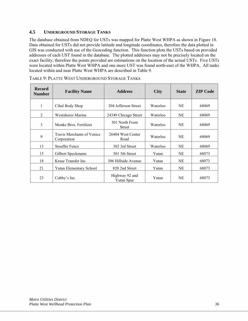
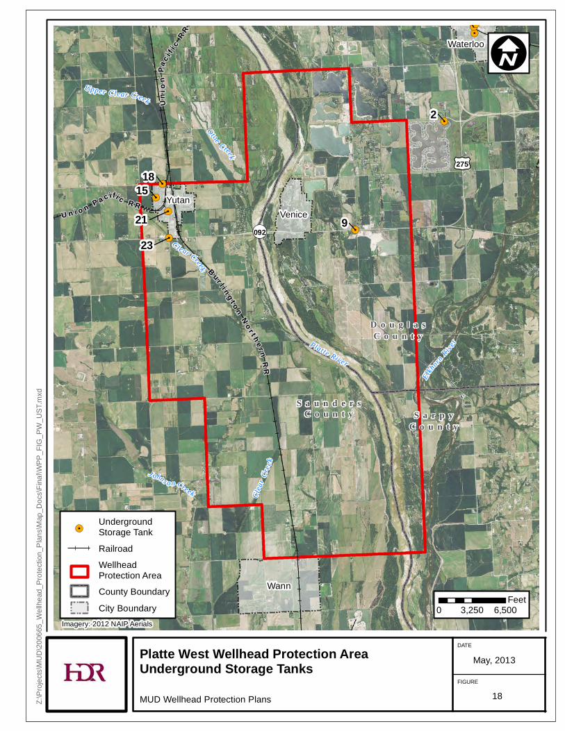
4.5 UNDERGROUND STORAGE TANKS The database obtained from NDEQ for USTs was mapped for Platte West WHPA as shown in Figure 18. Data obtained for USTs did not provide latitude and longitude coordinates, therefore the data plotted in GIS was conducted with use of the Geocoding function. This function plots the USTs based on provided addresses of each UST found in the database. The plotted addresses may not be precisely located on the exact facility; therefore the points provided are estimations on the location of the actual USTs. Five USTs were located within Platte West WHPA and one more UST was found north-east of the WHPA. All tanks located within and near Platte West WHPA are described in Table 9.
TABLE 9: PLATTE WEST UNDERGROUND STORAGE TANKS
Record Number Facility Name Address City State ZIP Code
1 Cihal Body Shop 204 Jefferson Street Waterloo NE 68069
2 Westshores Marina 24349 Chicago Street Waterloo NE 68069
3 Monke Bros. Fertilizer 301 North Front Street Waterloo NE 68069
9 Travis Merchants of Venice Corporation
26404 West Center Road Waterloo NE 68069
13 Stouffer Fence 302 3rd Street Waterloo NE 68069
15 Gilbert Speckmann 501 5th Street Yutan NE 68073
18 Kruse Transfer Inc. 306 Hillside Avenue Yutan NE 68073
21 Yutan Elementary School 820 2nd Street Yutan NE 68073
23 Cubby’s Inc. Highway 92 and Yutan Spur Yutan NE 68073
!.
!.
!.
!.
!.
!.
!.
!.
!.
Waterloo
YutanVenice
Wann
S a u n d e r sC o u n t y S a r p y
C o u n t y
D o u g l a sC o u n t y
2
9
18
2123
15
3
£¤275
¬«092U n i o n P a c ifi c R R
Unio
nPa
c i f ic
R R
B u r l i n g t o nN o r t h e r n
RR
Clea
r Cree
k
Otoe Creek
C lear Creek
J ohns on Creek
Upper Clear Creek
Elkhorn
RiverPla tte River
Platte West Wellhead Protection AreaUnderground Storage TanksMUD Wellhead Protection Plans
DATE
FIGURE
May, 2013
Z:\Pr
ojects
\MUD
\2006
65_W
ellhe
ad_P
rotec
tion_
Plans
\Map
_Doc
s\Fina
l\WPP
_FIG
_PW
_UST
.mxd
I
0 3,250 6,500Feet
!.UndergroundStorage TankRailroadWellheadProtection AreaCounty BoundaryCity Boundary
Imagery: 2012 NAIP Aerials
18
Metro Utilities District Platte West Wellhead Protection Plan 38
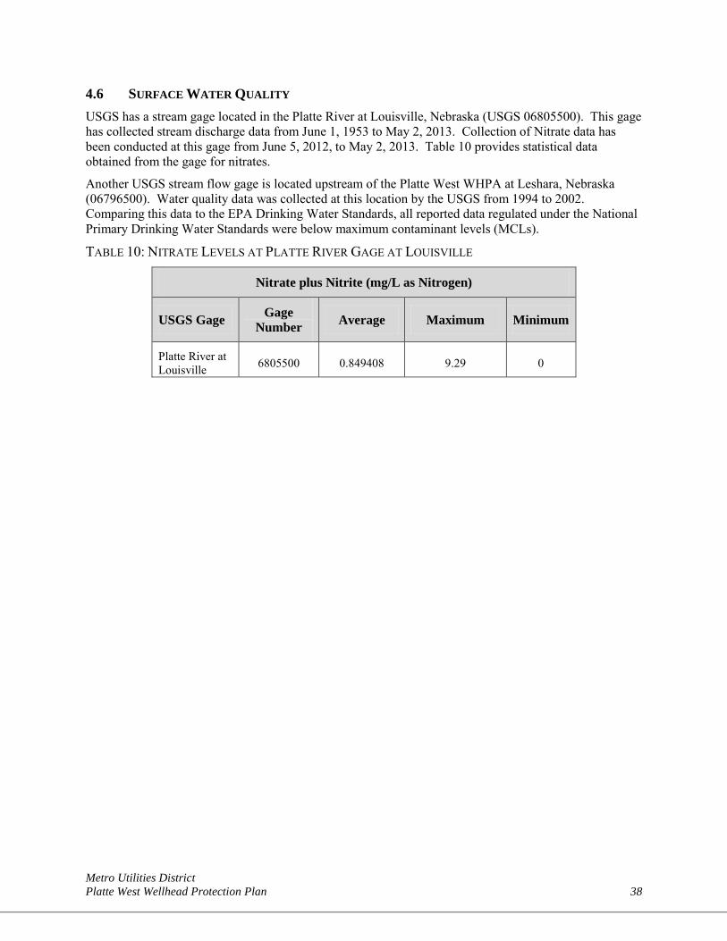
4.6 SURFACE WATER QUALITY USGS has a stream gage located in the Platte River at Louisville, Nebraska (USGS 06805500). This gage has collected stream discharge data from June 1, 1953 to May 2, 2013. Collection of Nitrate data has been conducted at this gage from June 5, 2012, to May 2, 2013. Table 10 provides statistical data obtained from the gage for nitrates.
Another USGS stream flow gage is located upstream of the Platte West WHPA at Leshara, Nebraska (06796500). Water quality data was collected at this location by the USGS from 1994 to 2002. Comparing this data to the EPA Drinking Water Standards, all reported data regulated under the National Primary Drinking Water Standards were below maximum contaminant levels (MCLs).
TABLE 10: NITRATE LEVELS AT PLATTE RIVER GAGE AT LOUISVILLE
Nitrate plus Nitrite (mg/L as Nitrogen)
USGS Gage Gage Number Average Maximum Minimum
Platte River at Louisville 6805500 0.849408 9.29 0
Metro Utilities District Platte West Wellhead Protection Plan 39
SECTION 5: MANAGEMENT STRATEGIES A WHPP may not be successful unless local ordinances, county zoning, or voluntary activities within the WHPA are enacted. A management plan for the WHPA is designed to layout the framework for available options to help protect drinking water supplies. Some examples of management options include incentives to use agricultural BMPS and best management of the well field.
5.1 EXISTING WELL FIELD MANAGEMENT PRACTICES Under most climatic and water demand conditions, the operating plan for well field is to simultaneously pump wells on both the Douglas County and Saunders County sides at an approximate distribution of 35 and 65 percent of total pumping, respectively. However, given the number of wells and the distribution of these wells, the well field can be managed to respond to a variety of different climatic and demand situations.
As stated in Section 1, the WHPP was not developed in response to any single specific issue. However, there are several parameters that are monitored that could impact the operation of the well field, including: low streamflow levels, changes in source water quality associated with spring runoff (such as an increase in nitrate or atrazine), and nitrate in groundwater. The following section explains what procedures are in place to monitor for these concerns and what can be done to address these concerns in the future.
5.1.1 Monitoring Stream Flow Conditions MUD monitors the stream flow conditions in the Platte River by reviewing the instantaneous data available at several gages that are upstream and downstream of the well field. MUD provides funding assistance to USGS to ensure that these stream gages continue to remain available. The gages that are monitored by MUD include:
• 06796500 Platte River near Leshara, Nebraska (upstream of the well field);
• 06796550 Platte River near Venice, Nebraska (at the well field); and
• 06801000 Platte River near Ashland, Nebraska (downstream of the well field).
The stream flow conditions observed at these gage locations influence the operation of the well field. For example, during periods of sustained low flow in the Platte River, MUD can shift well pumping to wells that are located further from the Platte River in an attempt to preserve flow in the river. During periods of high river flow, MUD can shift pumping to wells near the river in an attempt to maximize infiltration.
5.1.2 Water Quality Monitoring The quality of the source water entering the water treatment facility is monitored by testing the blended raw water as it enters the treatment facility. This monitoring is performed by MUD staff using an Enzyme-Linked Immunosorbent Assay (ELISA) testing method. The specific ELISA test method used by MUD is the triazine metabolite, which is an immunoassay for the quantitative and sensitive detection of diaminochlorotriazine and other triazine herbicide metabolites (of which atrazine is a member). The test is suitable for the quantitative and qualitative detection of these triazine metabolites in water samples.
Although the ELISA tests are triazine specific rather than atrazine specific, the ELISA test is used by MUD as a rapid screen test to determine if triazines are present in the raw water. During the spring planting season, which typically begins in April, MUD collects two samples per week from both the raw water intake and the finished water exiting the treatment facility.
Metro Utilities District Platte West Wellhead Protection Plan 40
The results of the tests are used to adjust the pumping distribution in the well field. For example, if triazine is detected in the raw water, pumping can be shifted from wells that are close to the river to wells that are further inland.
5.1.3 Well Field Operation During times of average stream flow and river water quality conditions, the base well field production will typically be provided by the wells that are located closest to the river. This operational practice minimizes the drawdown induced in the aquifer as a majority of the water is derived from river bank filtration. The benefit to using this as the BMP of the well field is that it minimizes the water pumped from aquifer storage, leaving this water available for use during periods when the water quality in the river is less desirable.
During periods of undesirable water quality in the Platte River, the well field can be managed by shutting off wells closest to the river and shift to pumping from wells that are located farther from the Platte River; or MUD may completely shut down the well field and shift the water supply production to either or both the Platte South or Florence water treatment facilities.
5.2 EXISTING LAND USE CONTROLS The communities and counties located within the Platte West WHPA control land uses with their adopted Comprehensive Plans and Zoning Ordinances. A list of the existing zoning controls in place within the Platte West WHPA is presented in Appendix A. No well head protection ordinances exist within the Platte West WHPA.
MUD cannot enforce or implement zoning. However, through partnerships with the local jurisdictions, an inter-local agreement can assist MUD and the jurisdictions with the enactment of a wellhead protection overlay zone or adjust current zoning to allow for oversight of activities in portions of the zoning jurisdictions of the communities and counties. An example of a well head protection ordinance is provided in Appendix B.
5.2.1 Natural Resource District Groundwater Management The area of influence for the MUD Platte West well field is within the Lower Platte North (LPN) NRD and the Papio-Missouri River (Papio) NRD’s jurisdictions. These NRDs have Groundwater Management Plans, which outline specific steps necessary to protect and enhance the resource.
Since 1985, the Lower Platte North NRD has been monitoring nitrate levels across the district. In certain areas of the district, nitrate levels have already exceeded the health standard of 10 parts per million, and in other areas contamination seems to be on the rise. This was the major impetus for the creation of the Ground Water Management Area in 1997.
Excessive nitrates in drinking water, often linked to irrigated row crop production, can endanger pregnant women and infants by interfering with the oxygen-carrying capacity of the blood. Some studies have also linked excessive nitrate consumption with increased incidence of gastrointestinal cancer, but these reports remain unconfirmed.
To help correct the rising nitrate levels in the groundwater, the LPN NRD has set requirements for producers who use fertilizer in the district. The MUD Platte West well field is within Phase I of the plan, which emphasizes education about fertilizer use.
The Papio-Missouri River NRDs Groundwater Management Plan focuses on maintaining the quantity and quality of ground-water in our area. This task includes:
• Testing the water of 100 wells for nitrates every five years
Metro Utilities District Platte West Wellhead Protection Plan 41
• Establishing management areas if the ground-water reservoir life goal can’t be met
• Continuing to administer permits for chemigation (application of agricultural chemicals through irrigation)
• And evaluating the need of rural landowners for a dependable drinking water supply.
5.3 POTENTIAL FUTURE MANAGEMENT STRATEGIES MUD can establish a comprehensive management strategy to layout the framework for on-the-ground actions to protect its drinking water source over the next 10 to 20 years. The ultimate goal of the management practice recommendations is to provide the community with the best possible management strategies, which are both implementable and protective of the water supply for the community. It is important to note that the management strategies outlined below, while endorsed by NDEQ, were developed based on the potential pollution sources identified through the potential contaminant source inventory, land use evaluation, and comments gathered through the community planning process.
Educational activities and voluntary approaches should be considered the core of the recommended management strategies for MUD’s WHPP because these can be implemented now. Furthermore, even though MUD is owner and operator of the community water system, it does not have jurisdiction over all of the land identified in the WHPAs. Consequently, educational activities, inter-local agreements, and voluntary approaches offer the greatest potential for more immediate and successful plan implementation.
Management strategies outlined below are general in nature. Specific strategies should be developed on a case-by-case basis through working with the Wellhead Advisory Committee, the community, and the landowners.
5.3.1 Public Education –
MUD has provided education opportunities in the past and will continue to provide opportunities to educate all ages of citizens and property owners, in and around the WHPA, about the importance of source water protection. Public education efforts may include, but are not limited to:
• Focus groups
• Community workshops
• Press releases
• Distributing brochures
• School poster contests
• News/information articles
• Utility bill stuffers
Education opportunities could be on a variety of topics, such as:
• Proper animal waste handling
• Aquifer and groundwater basics
• Private well and lagoon management
• Urban and rural BMP practices
Metro Utilities District Platte West Wellhead Protection Plan 42
5.3.2 Wellhead Protection Area Signs Once the WHPP is approved, MUD can post WHPA signs in the affected areas to alert property owners to the issues. These signs can be supplemented with information regarding the existing land use regulations and directing property owners to contact MUD.
5.3.3 Conservation Reserve Program Agricultural producers with farmed land in a WHPA are eligible for increased payment amounts for enrolling land in the Conservation Reserve Program (CRP) when located in a WHPA. The local NRD and Natural Resources Conservatoin Service (NRCS) office will assist in this.
5.3.4 Best Management Practices BMPs offer an effective prevention strategy or solution to a potential water quality challenge. Selection of the most appropriate BMP or combination of BMPs under a voluntary approach is each individual’s decision.
Well decommissioning – If not properly sealed at the surface, water wells can become a conduit between surface water runoff and ground water. Financial assistance programs to ensure that wells are properly decommissioned are available through the LPN NRD and Papio Missouri NRD. There may also be assistance in the future through MUD.
Agricultural BMP – Incentives BMPs focus on management of agricultural inputs to provide for economic, environmental, and agronomic efficiency in agriculture. Implementation of BMPs will reduce the potential of contamination of the source water aquifer. The LPN NRD provides cost-share assistance to landowners for establishing a variety of agricultural related conservation practices such as:
• Construction of new terraces
• Irrigation Water Management
• Planned Grazing Management Systems – including: cross fencing, livestock water dugouts, livestock well installation, pumping plants for livestock wells, livestock water tanks, and livestock water pipeline installation)
• Windbreak Management
• Construction of sediment and water control basins
• Nitrogen Management
• Establish of warm and cool season grasses on crop ground
Urban BMP Incentives – MUD and the local NRDs could encourage residents to utilize incentives to adopt BMPs in the urban setting such as:
• Use of native plants in lawns and landscapes
• Recycling
• Soil sampling of lawns
• Mulching lawn clippings
• Rain barrels and rain gardens
• Household hazardous waste collection
Metro Utilities District Platte West Wellhead Protection Plan 43
SECTION 6: EMERGENCY AND CONTINGENCY PLANS As described in Section 2, Omaha’s MUD water system is now comprised of three treatment facilities: Florence Water Treatment facility, Platte South Water Treatment facility, and Platte West Water Treatment facility (see Figure 1). In total, these three facilities can produce up to 333 mgd of treated water supply to meet peak day demands. The source water for these three treatment facilities is approximately split in half between the Missouri and Platte rivers, minimizing the threat of a loss of supply should the supply from one river source be temporarily unavailable. The placement of the three water treatment facilities and their alternative water supply sources create a triangle of reliability for the District’s water supply. The diversity of MUD’s source of water supply provides a significant advantage to the District in its ability to use an alternative supply source in the event of an emergency in any one of the sources. This concept of the triangle of reliability, with varied sources of supply, is key in MUD’s emergency and contingency planning. A description of those plans is provided below.
6.1 EMERGENCY PLANS MUD’s water operations emergency plan, including emergency contact sheets, was last updated in June 2012. The cover page for the emergency plan is located in Appendix C. Because of the sensitive security information in the emergency plan, a full copy of the plan is not included. In case of a water operations emergency at the Platte West Water Treatment facility, the proper personnel (as outlined in the emergency plan) will be contacted, an assessment of the problem will be conducted, and an isolation of the damaged facility or system will occur if necessary. Inspection of the site will determine the next step and what decisions may need to made according to the type of problem.
6.2 SPILLS In the event of a spill of hazardous material into the Missouri River or Platte River above the MUD intakes, the spill procedure, located in Appendix D, should be followed. In general, one of the following agencies may notify the district:
• Omaha Public Power District
• U.S. Coast Guard
• U.S. Environmental Protection Agency
• USACE
• Nebraska State Health Department
• Nebraska Game and Parks Commission
• NDEQ
• Iowa Department of Natural Resources
The agencies will notify the Districts Communications Clerk, who will record the following information:
1. The type and quantity of material spilled, if known.
2. The location of the spill.
3. The time of the spill, if known.
4. The name, phone number, and agency of the person calling.
The District Communications Clerk will then immediately notify the facility Superintendent and the Vice President of Water Operations. In the absence of the Vice President of Water Operations, the District Communications Clerk will notify the Water Supply Engineer or other designated person in charge of
Metro Utilities District Platte West Wellhead Protection Plan 44
Water Operations. The Vice President of Water Operations, or designee, will notify the President and the Senior Vice President of Operations, if operation is affected.
Subsequently, the Vice President of Water Operations, or designee, will decide on an appropriate response. More information about the spill may be needed. Consultation with Water Quality or others may be needed. Actions may include observation of river conditions and raw water quality, additional treatment or temporarily discontinuing water intake. The Vice President of Water Operations will be responsible for appropriate communication regarding the situation and response.
The Vice President of Water Operations or the District Communications Clerk will notify the appropriate water treatment facility supervisor, the Director of Water Quality, the Safety and Security Office, and/or the Senior Communication Specialist.
6.3 OPERATIONS EMERGENCY PLANS If a major emergency or disaster would cause curtailment of water from the facility, the duty operator will notify the facility Superintendent, the Vice President of Water Operations, and Systems Control. The Vice President of Water Operations will evaluate the problem and notify the Senior Vice President of Operations (if necessary). The Superintendent of the Platte West Water Treatment facility and/or facility foreman will report to the facility (if necessary).
A command room will be set up in the conference room. Additional help will be called in if phones are in service. Mobile radios will also be used to relay phone numbers and messages to people needed to report to work. Additional help could come from Water Distribution, Engineering, Platte South, Florence, the Maintenance Division, or the Construction Division.
6.3.1 Assessment of Problem The Superintendent of the Platte West Water Treatment facility shall call in additional supervisors and operating personnel (if phones are available) to determine the extent of the damage. The personnel should be sent out in teams to evaluate the damage and report back to the command center. The command center leader (Superintendent of Platte West Water Treatment facility or Vice President of Water Operations) will report the following to District Management:
1. Nature and extent of damage
2. Estimated time to repair
3. Pumping capacity available
4. Need to curtail water pumpage
5. Support personnel and other resources needed for repair and clean-up
6. Applicability of the District’s Water Conservation Plan
6.3.2 Isolation of Damaged Facilities The Superintendent of the Platte West Water Treatment facility, Vice President of Water Operations, or other designated management, shall direct the isolation of affected area. The Superintendent of Water Distribution shall make personnel available for valve operation if needed. When affected areas have been isolated, the Superintendent of the Platte West Water Treatment facility, Vice President of Water Operations, Engineering, and possibly the Superintendent of Water Distribution, shall determine the type of repairs needed and provide people needed to complete repairs, etc. The Director of Water Quality should also be informed of the type of problems, and supply personnel for bacteriological testing, if it is determined to be necessary.
Metro Utilities District Platte West Wellhead Protection Plan 45
The command center personnel should keep management informed. The reports received by management from the command center should enable the following decisions to be made:
1. The need to curtail production
2. Notifying appropriate regulatory agencies
3. The need to isolate water in storage
4. News releases to the public
6.3.3 Chlorine or Ammonia Leak Emergency A chlorine or ammonia leak emergency will be handled in accordance with the Chlorine and Ammonia Manual.
6.3.4 Flood Emergency A flooding emergency within and around the Platte West well field will be handed in accordance with the Platte West Flood Emergency Response Plan in the Emergency Notification Procedures manual.
6.4 SUPERVISORY CONTROL AND DATA ACQUISITION EMERGENCY PLANS If the emergency involves the Supervisory Control and Data Acquisition (SCADA) system, tele-communications or other circumstance where the operating center is usable for voice communications, the systems control area will be the command center.
If the Operating Center is unusable, the Command Center will be located at the Florence Water Treatment facility or other, suitable location. (It is assumed that if the operating center is unavailable, the dispatchers and others will be using the Platte West Water Treatment facility or the construction center.)
The Controller, Water Supply Engineer, or Vice President of Water Operations will be the coordinator.
6.4.1 Assessment of Problem The coordinator will assess the problem and report to District Management the following:
1. Nature and extent of the problem
2. Estimated time to repair
3. Personnel and other resources needed for continued operation and repair
4. Need to notify the public of the problem
5. Need to notify appropriate regulatory agencies
6. Need for isolating water in storage
6.4.2 Emergency Operations The coordinator will determine the need for manual operation of facilities and call out personnel such as off-duty operating personnel, electricians, instrument technicians, and others to manually operate key facilities. Repump stations should be put on automatic operation to the extent possible. The controllers will initiate manual recordkeeping of the system operation.
If the emergency operation is extended, dedicated telephone lines and a backup SCADA system will be installed at the command center. Note: A backup systems control center at Platte West Water Treatment facility will be operational in the future.
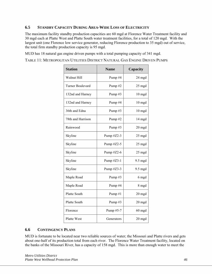
Metro Utilities District Platte West Wellhead Protection Plan 46
6.5 STANDBY CAPACITY DURING AREA-WIDE LOSS OF ELECTRICITY The maximum facility standby production capacities are 60 mgd at Florence Water Treatment facility and 30 mgd each at Platte West and Platte South water treatment facilities, for a total of 120 mgd. With the largest unit (one Florence low service generator, reducing Florence production to 35 mgd) out of service, the total firm standby production capacity is 95 mgd.
MUD has 18 natural gas engine driven pumps with a total pumping capacity of 341 mgd.
TABLE 11: METROPOLITAN UTILITIES DISTRICT NATURAL GAS ENGINE DRIVEN PUMPS
Station Name Capacity
Walnut Hill Pump #4 24 mgd
Turner Boulevard Pump #2 25 mgd
132nd and Harney Pump #3 10 mgd
132nd and Harney Pump #4 10 mgd
36th and Edna Pump #3 10 mgd
78th and Harrison Pump #2 14 mgd
Rainwood Pump #3 20 mgd
Skyline Pump #Z2-3 25 mgd
Skyline Pump #Z2-5 25 mgd
Skyline Pump #Z2-6 25 mgd
Skyline Pump #Z3-1 9.5 mgd
Skyline Pump #Z3-3 9.5 mgd
Maple Road Pump #3 6 mgd
Maple Road Pump #4 8 mgd
Platte South Pump #1 20 mgd
Platte South Pump #3 20 mgd
Florence Pump #5-7 60 mgd
Platte West Generators 20 mgd
6.6 CONTINGENCY PLANS MUD is fortunate to be located near two reliable sources of water; the Missouri and Platte rivers and gets about one-half of its production total from each river. The Florence Water Treatment facility, located on the banks of the Missouri River, has a capacity of 158 mgd. This is more than enough water to meet the
Metro Utilities District Platte West Wellhead Protection Plan 47
customers’ average daily usage of 90 to 100 mgd. USACE regulates the Missouri River flow. The minimum sustained flow in the river is 8,000 cubic feet per second (cfs). At this rate, an amount of water equivalent to the 158 mgd facility capacity flows by MUD’s intakes every 44 minutes. The Platte South Water Treatment facility is located in Sarpy County on the Platte River. While the Platte River is more susceptible to low flows caused by a drought, as long as there is some flow in the river, the facility can produce 60 mgd capacity. The Platte West Water Treatment facility is located in Douglas County with well fields along the Platte River in both Douglas and Saunders counties. The facility can produce 100 mgd capacity. The triangle of reliability created with the three MUD water treatment facilities relieves the overall reliance of supply water from only one source by allowing other treatment facility sources to supply water demands to customers if needed.
The chance of experiencing a long-term water shortage in MUD’s water sources is remote, as the Platte and Missouri rivers are reliable long-term supplies. However, a possibility does exist for short-term water shortages. These could be drought-related, caused by limited facility or distribution system failures or due to any number of emergency situations. As previously described in the Emergency Plan, MUD’s contingency for most short-term water shortages is to shift the water production to the facilities that are not impacted. For example, if a long drought impacts the Platte River, more water production will be produced at the Florence Water Treatment facility.
If water demands exceed available production for any reason, it may be necessary to implement water use restrictions as a contingency. The water conservation contingency plan relies on public education, system conservation measures (such as leak detection and accurate metering), and public alerts.
Some examples of pieces of the Public Education Plan include:
• Wise water use messages on customer bills and wise water use tips in customer newsletters.
• Wise water use messages on the on-hold customer voice message system.
• Sponsor a wise water use flower garden at the Village Pointe Shopping Center in conjunction with the UNL Extension Office and Master Gardeners.
• A Water Conservation section on MUD’s website at www.mudomaha.com, which also includes wise water use tips, charts, statistics, and links to helpful resources.
• “Make Every Drop Count” rain gauges and moisture sensors are distributed to customers at community events.
• New customer booklet section with an extensive list of water conservation tips.
The water alert system part of the contingency plan is grouped into four levels, each imposing more restrictions than the last. The responsibility for calling for these alerts will be with the President and will be based on consultations with the Senior Vice President of Operations and with the Vice President of Water Operations. Once the decision has been made, it will be the responsibility of the Senior Vice President, Chief Customer Officer, and the Director of Corporate Communication to make the appropriate notification to the news media. The Water Conservation and Alert Plan is included in Appendix E, but the four levels are listed below.
• Level 1 Water Alert (Voluntary A Alternate Day Watering)
• Level 2 Water Alert (Voluntary No-Watering Days)
• Level 3 Water Alert (Mandatory watering restrictions)
• Level 4 Water Emergency (All non-sanitary, non-essential use of water must be discontinued.)
Metro Utilities District Platte West Wellhead Protection Plan 48
6.7 LONG-TERM PLANNING With the most recent addition of the Platte West Water Treatment facility in 2008, a reliable supply of high quality drinking water can be provided to the Greater Omaha Area. The Platte West Water Treatment facility added 100 mgd of capacity to the existing 234 mgd capacity from the Florence and Platte South water treatment facilities and ensures that MUD will be able to meet the maximum daily water demand beyond the year 2030. The completion of the Platte West well field provided an alternative source of supply water to enhance system reliability. It decreases the overall reliance on the water supplied from a surface water intake located in the Missouri River to the Florence Water Treatment facility and the Platte River supply to the Platte South Water Treatment facility. These three treatment facilities form a triangle of reliability to provide drinking water to the area. At this time, no additional water supply sources are required to meet the needs within the MUD service area beyond the year 2030.
Metro Utilities District Platte West Wellhead Protection Plan 49
SECTION 7: PUBLIC EDUCATION AND NOTIFICATION During the establishment of the Platte West WHPP, MUD identified key stakeholders that would be interested in the plan and established an Advisory Committee to provide input into the plan development. After two Advisory Committee meetings, MUD made the plan publicly available and collected comments and responded to questions from the general public about the plan. Appendix F contains additional Public Education and Notification materials.
7.1 METROPOLITAN UTILITIES DISTRICT PLATTE WEST WELLHEAD ADVISORY COMMITTEE A seventeen-member Advisory Committee was established at the beginning of the plan development. Members of the Advisory Committee include representatives of Douglas County, City of Lincoln, Lower Platte North NRD, Papio-Missouri River NRD, Two Rivers State Recreation Area, Lyman-Richey Corporation, Western Sand and Gravel, Lower Platte River Corridor Alliance, City of Yutan, and Saunders County. The Advisory Committee was responsible for providing key input into the plan through their attendance and discussions at the two Advisory Committee meetings. Below is a brief summary of the two Advisory Committee meetings and a list of the members.
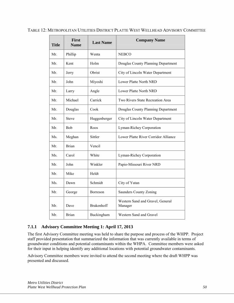
Metro Utilities District Platte West Wellhead Protection Plan 50
TABLE 12: METROPOLITAN UTILITIES DISTRICT PLATTE WEST WELLHEAD ADVISORY COMMITTEE
Title First Name Last Name Company Name
Mr. Phillip Wenta NEBCO
Mr. Kent Holm Douglas County Planning Department
Mr. Jerry Obrist City of Lincoln Water Department
Mr. John Miyoshi Lower Platte North NRD
Mr. Larry Angle Lower Platte North NRD
Mr. Michael Carrick Two Rivers State Recreation Area
Mr. Douglas Cook Douglas County Planning Department
Mr. Steve Huggenberger City of Lincoln Water Department
Mr. Bob Roos Lyman-Richey Corporation
Ms. Meghan Sittler Lower Platte River Corridor Alliance
Mr. Brian Vencil
Ms. Carol White Lyman-Richey Corporation
Mr. John Winkler Papio-Missouri River NRD
Mr. Mike Heldt
Ms. Dawn Schmidt City of Yutan
Mr. George Borreson Saunders County Zoning
Mr. Dave Brakenhoff Western Sand and Gravel, General Manager
Mr. Brian Buckingham Western Sand and Gravel
7.1.1 Advisory Committee Meeting 1: April 17, 2013 The first Advisory Committee meeting was held to share the purpose and process of the WHPP. Project staff provided presentation that summarized the information that was currently available in terms of groundwater conditions and potential contaminants within the WHPA. Committee members were asked for their input in helping identify any additional locations with potential groundwater contaminants.
Advisory Committee members were invited to attend the second meeting where the draft WHPP was presented and discussed.
Metro Utilities District Platte West Wellhead Protection Plan 51
7.1.2 Advisory Committee Meeting 2: June 4, 2013 The second Advisory Committee meeting was held to present a draft version of the WHPP. Project staff provided a presentation that summarized the WHPP and requested input and formal comments from the Advisory Committee members. The comment period was held open until July 10, 2013. The comments provided by the Advisory Committee members were included in this document.
7.2 PUBLIC COMMENT PERIOD AND PUBLIC BOARD MEETING Public comment on the WHPP was sought as part of the plan development. The plan was advertised on August 4, 2013, in a Sunday printing of the Omaha World-Herald. Communication regarding the availability of the plan was improved by including notification of the plan with MUD’s July utility bill.
7.2.1 Public Comment Period: August 5, 2013 The plan was made available to the public on August 5, 2013, as an online document found on MUD’s website.
(Placeholder for future summary of comments received)
7.2.2 MUD Board Meeting – Public Comment Received: September 4, 2013 The public was invited to attend a regularly scheduled MUD Board meeting on September 4, 2013, to hear discussion of the plan, ask questions, and provide comments.
(Placeholder for future summary of discussion and comments made)
Metro Utilities District Platte West Wellhead Protection Plan 52
SECTION 8: REFERENCES Chatman and Associates, Inc. 2005. Phase II Platte West Well Field Groundwater Modeling Study.
Metropolitan Utilities District. Platte West Well Field, Nebraska. Prepared for HDR Engineering, Inc. November.
McDonald, M.G. and Harbaugh, A.W. 1988. A Modular Three-Dimensional Finite-Difference Ground-Water Flow Model. U.S. Geological Survey, Techniques of Water-Resources Investigations of the U.S. Geological Survey, Book 6, Chapter A1.
Pollock, D.W. 1989. Documentation of Computer Programs to Compute and Display Pathlines Using Results from the U.S. Geological Survey Modular Three-Dimensional, Finite-Difference, Groundwater Flow Model. USGS Open File Report.
Metro Utilities District Platte West Wellhead Protection Plan 53
This Page Intentionally Left Blank

Metro Utilities District Platte West Wellhead Protection Plan 54
APPENDIX A Existing Zoning Controls
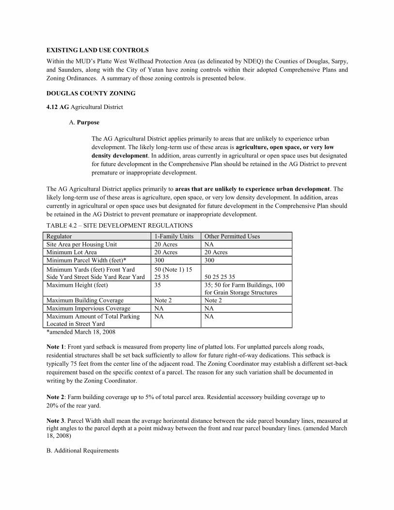
EXISTING LAND USE CONTROLS
Within the MUD’s Platte West Wellhead Protection Area (as delineated by NDEQ) the Counties of Douglas, Sarpy, and Saunders, along with the City of Yutan have zoning controls within their adopted Comprehensive Plans and Zoning Ordinances. A summary of those zoning controls is presented below.
DOUGLAS COUNTY ZONING
4.12 AG Agricultural District
A. Purpose
The AG Agricultural District applies primarily to areas that are unlikely to experience urban development. The likely long-term use of these areas is agriculture, open space, or very low density development. In addition, areas currently in agricultural or open space uses but designated for future development in the Comprehensive Plan should be retained in the AG District to prevent premature or inappropriate development.
The AG Agricultural District applies primarily to areas that are unlikely to experience urban development. The likely long-term use of these areas is agriculture, open space, or very low density development. In addition, areas currently in agricultural or open space uses but designated for future development in the Comprehensive Plan should be retained in the AG District to prevent premature or inappropriate development.
TABLE 4.2 – SITE DEVELOPMENT REGULATIONS
Regulator 1-Family Units Other Permitted Uses Site Area per Housing Unit 20 Acres NA Minimum Lot Area 20 Acres 20 Acres Minimum Parcel Width (feet)* 300 300 Minimum Yards (feet) Front Yard Side Yard Street Side Yard Rear Yard
50 (Note 1) 15 25 35 50 25 25 35
Maximum Height (feet) 35 35; 50 for Farm Buildings, 100 for Grain Storage Structures
Maximum Building Coverage Note 2 Note 2 Maximum Impervious Coverage NA NA Maximum Amount of Total Parking Located in Street Yard
NA NA
*amended March 18, 2008
Note 1: Front yard setback is measured from property line of platted lots. For unplatted parcels along roads, residential structures shall be set back sufficiently to allow for future right-of-way dedications. This setback is typically 75 feet from the center line of the adjacent road. The Zoning Coordinator may establish a different set-back requirement based on the specific context of a parcel. The reason for any such variation shall be documented in writing by the Zoning Coordinator.
Note 2: Farm building coverage up to 5% of total parcel area. Residential accessory building coverage up to 20% of the rear yard.
Note 3. Parcel Width shall mean the average horizontal distance between the side parcel boundary lines, measured at right angles to the parcel depth at a point midway between the front and rear parcel boundary lines. (amended March 18, 2008)
B. Additional Requirements
1. All new subdivisions and lots must comply with the Conservation Development Regulations in Article 7.
C. Exception for Farmstead Lots.
The intent of this exception is to allow a one-time split of a farmstead lot out of any qualifying parcel as of the effective date of these regulations.
1. Farmstead Lots must meet the following requirements:
a. The parcel of land before subdivision must be greater than 23 acres and the remaining parcel after subdivision must be greater than 20 acres; and,
b. The minimum lot area shall be three (3) acres in size; and,
c. The lot created shall meet the requirements as defined in the subdivision regulations.
d. A given parcel is restricted to one (1) farmstead lot split as of the effective date of the amendment. The remaining (20+ acres) parcel of land cannot have another farmstead lot split. The intent is to prevent creation of more than one farmstead lot out of any qualifying parcel existing as of the effective date of these regulations. At the discretion of the Zoning Coordinator, additional farmstead lot splits may be considered if structures related to the uses in part “e” exist, an individual well and septic already exist on the proposed lot (i.e. are in existence as of the effective date of these regulations), and the additional farmstead lot split(s) is/are done at the same time.
e. The primary use of the original parcel must be associated with crop production, animal production, or a commercial feedlot.
4.14 RR-2 District. Rural Residential with individual services
A. Purpose
Provides for the rural residential use of land, accommodating low density developments on individual wells and septic systems. The district also provides for previously platted acreage lots in (formerly) agricultural zone districts of between 3 and 20 acres in size that would be nonconforming as of the effective date of this regulation. TABLE 4.4 – SITE DEVELOPMENT REGULATIONS
Regulator 1-Family Units Other Permitted Uses Site Area per Housing Unit 3 Acres NA Minimum Lot Area 3 Acres 3 Acres Minimum Lot Width (feet) 100 100 Minimum Yards (feet) Front Yard Side Yard Street Side Yard Rear Yard 50 25 25 35 50 25 20 35 Maximum Height (feet) 35 36 Maximum Building Coverage Note 1 Note 1 Maximum Impervious Coverage NA NA Maximum Amount of Total Parking Located in Street Yard
NA NA
Project Size Requiring Planned Development District (PD)
NA NA
Note 1: Residential accessory building coverage up to 20% of the rear yard.
Note 2. Subdivision of property for residential use is not allowed in the one half mile buffer zone around the active industrial waste monofill operation at the Douglas County RDF Landfill site, the industrial waste monofill site located south of the Douglas County RDF Landfill site permitted by Conditional Use Permit issued to Waste Management, and the Pheasant Point Landfill. (amended March 18, 2008)
B. Additional Requirements.
1. All new subdivisions and lots must comply with the Conservation Development Regulations in Article 7.
2. Currently platted lots, in existence as of the effective date of this regulation, are encouraged to use elements of Conservation Development if possible.
3. Open space requirements for new subdivisions (percentage of the development that must be dedicated open space and protected from future development)
For gross densities:
(i) 1 unit per 3 to 5 acres inclusive – 50%
(ii) Greater than 1 unit per 5 acres to 1 unit per 10 acres inclusive – 70% (iii) Greater than 1 unit per 10 acres to 20 acres inclusive – 90%
SARPY COUNTY ZONING SECTION 9 – AG - AGRICULTURAL FARMING DISTRICT (20 acres) The intent and purpose of this district is for the conservation and preservation of the agriculture areas of the County and to retain its economic asset to the County. 9.1 PRINCIPAL PERMITTED USES The following principal uses are permitted in the Agricultural District:
9.1.1 Agricultural, horticultural, viniculture, aquaculture, ranching and the usual agricultural buildings and structures associated with such uses.
9.1.2 Farm dwellings for the owners and their families, tenants, and employees. 9.1.3 Feeding and raising of livestock where a portion of the feed is raised and the feeding and raising is in the
normal operation of an agricultural use. 9.1.4 Public utility main transmission lines or pipelines including substations, distribution centers, regulator
stations, pumping stations storage, equipment buildings towers, or similar public service uses. 9.1.5 Public parks and recreation areas, playgrounds, forests and conservation areas. Private recreation areas and
facilities, including lakes and ponds. 9.1.6 Personal use of Recreational Vehicles. 9.1.7 Religious facilities, including residences for religious leaders and teachers. 9.1.8 Roadside stands offering for sale agricultural products produced on the premises. 9.1.9 Single Family Dwellings 9.2 PERMITTED SPECIAL USES The following special uses are permitted in the Agriculture Farming District with the issuance of a special use
permit: 9.2.1 Automobile wrecking and junk yards provided the yards are at least 500 feet from a State or U.S.
designated highway and screened by a wall at least 50 percent solid or uniformly painted solid fence not less than 6 feet in height with deciduous evergreen trees and large shrubs to provide a landscape screen at least 10 feet high.
9.2.2 Commercial feed lots for cattle, swine, poultry facilities, mink, fox, chinchilla, or similar farms. 9.2.3 Commercial recreational areas and camping areas including fishing lakes, gun clubs, rifle ranges, trap
shoots, and similar uses. 9.2.4 Commercial fertilizer trailer tank farms. 9.2.5 Construction and demolition waste disposal sites. 9.2.6 Country clubs, golf courses, tennis clubs, and swimming clubs. 9.2.7 Extraction and processing of rock, gravel or sand, clay, and dirt. 9.2.8 Mobile homes with intermittent occupancy for recreational use only.
9.2.9 Nursing homes, cemeteries, and charitable institutions. 9.2.10 Open and enclosed storage of recreational vehicle and trailers; when recreational vehicles are stored in the
open, the recreational vehicles must be operable. 9.2.11 Other agricultural wastes disposal and storage sites. 9.2.12 Private and commercial kennels and facilities for raising, breeding, and boarding of dogs and other small
domestic animals, provided all buildings and facilities are at least 100 feet from any property line and 300 feet from any residential zoning districts.
9.2.13 Private small non-commercial air landing fields or strips. 9.2.14 Private schools, colleges and universities. 9.2.15 Publicly-owned and operated buildings and facilities such as community centers, auditoriums, libraries,
museums, and privately owned non-commercial museums and historic areas. 9.2.16 Radio, television, and communication towers and transmitters 9.2.17 Sanitary sewage treatment facilities. 9.2.18 Sanitary landfills. 9.2.19 Seasonal dwellings. 9.2.20 Sludge disposal and storage sites. 9.2.21 In-home Child Care Facility 9.2.22 Wind Energy Generation Systems 9.2.23 Use of recreational vehicles in a commercial recreational or camping area 9.2.24 Home Occupations I (Major).
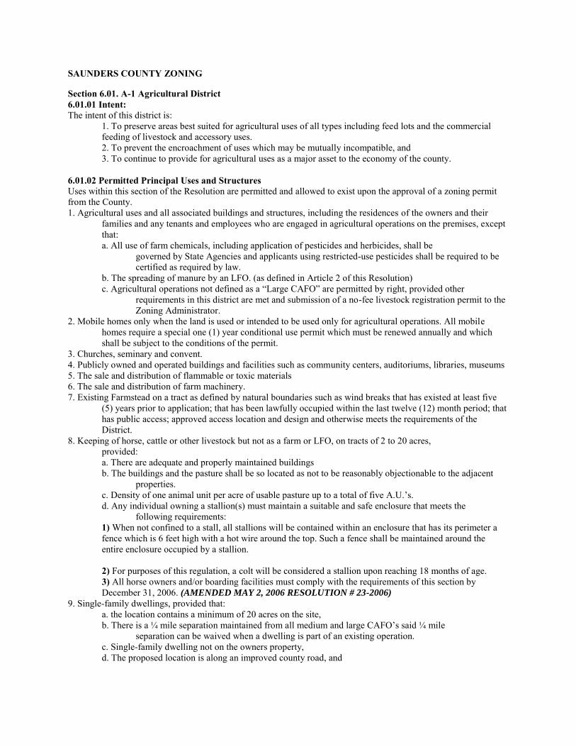
SAUNDERS COUNTY ZONING
Section 6.01. A-1 Agricultural District 6.01.01 Intent: The intent of this district is:
1. To preserve areas best suited for agricultural uses of all types including feed lots and the commercial feeding of livestock and accessory uses. 2. To prevent the encroachment of uses which may be mutually incompatible, and 3. To continue to provide for agricultural uses as a major asset to the economy of the county.
6.01.02 Permitted Principal Uses and Structures Uses within this section of the Resolution are permitted and allowed to exist upon the approval of a zoning permit from the County. 1. Agricultural uses and all associated buildings and structures, including the residences of the owners and their
families and any tenants and employees who are engaged in agricultural operations on the premises, except that: a. All use of farm chemicals, including application of pesticides and herbicides, shall be
governed by State Agencies and applicants using restricted-use pesticides shall be required to be certified as required by law.
b. The spreading of manure by an LFO. (as defined in Article 2 of this Resolution) c. Agricultural operations not defined as a “Large CAFO” are permitted by right, provided other
requirements in this district are met and submission of a no-fee livestock registration permit to the Zoning Administrator.
2. Mobile homes only when the land is used or intended to be used only for agricultural operations. All mobile homes require a special one (1) year conditional use permit which must be renewed annually and which shall be subject to the conditions of the permit.
3. Churches, seminary and convent. 4. Publicly owned and operated buildings and facilities such as community centers, auditoriums, libraries, museums 5. The sale and distribution of flammable or toxic materials 6. The sale and distribution of farm machinery. 7. Existing Farmstead on a tract as defined by natural boundaries such as wind breaks that has existed at least five
(5) years prior to application; that has been lawfully occupied within the last twelve (12) month period; that has public access; approved access location and design and otherwise meets the requirements of the District.
8. Keeping of horse, cattle or other livestock but not as a farm or LFO, on tracts of 2 to 20 acres, provided: a. There are adequate and properly maintained buildings b. The buildings and the pasture shall be so located as not to be reasonably objectionable to the adjacent
properties. c. Density of one animal unit per acre of usable pasture up to a total of five A.U.’s. d. Any individual owning a stallion(s) must maintain a suitable and safe enclosure that meets the
following requirements: 1) When not confined to a stall, all stallions will be contained within an enclosure that has its perimeter a fence which is 6 feet high with a hot wire around the top. Such a fence shall be maintained around the entire enclosure occupied by a stallion. 2) For purposes of this regulation, a colt will be considered a stallion upon reaching 18 months of age. 3) All horse owners and/or boarding facilities must comply with the requirements of this section by December 31, 2006. (AMENDED MAY 2, 2006 RESOLUTION # 23-2006)
9. Single-family dwellings, provided that: a. the location contains a minimum of 20 acres on the site, b. There is a ¼ mile separation maintained from all medium and large CAFO’s said ¼ mile
separation can be waived when a dwelling is part of an existing operation. c. Single-family dwelling not on the owners property, d. The proposed location is along an improved county road, and
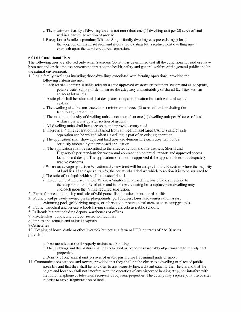
e. The maximum density of dwelling units is not more than one (1) dwelling unit per 20 acres of land within a particular section of ground
f. Exception to ¼ mile separation: Where a Single-family dwelling was pre-existing prior to the adoption of this Resolution and is on a pre-existing lot, a replacement dwelling may encroach upon the ¼ mile required separation.
6.01.03 Conditional Uses The following uses are allowed only when Saunders County has determined that all the conditions for said use have been met and/or that the use presents no threat to the health, safety and general welfare of the general public and/or the natural environment. 1. Single family dwellings including those dwellings associated with farming operations, provided the
following criteria are met: a. Each lot shall contain suitable soils for a state approved wastewater treatment system and an adequate,
potable water supply or demonstrate the adequacy and suitability of shared facilities with an adjacent lot or lots.
b. A site plan shall be submitted that designates a required location for each well and septic system.
c. The dwelling shall be constructed on a minimum of three (3) acres of land, including the land to any section line.
d. The maximum density of dwelling units is not more than one (1) dwelling unit per 20 acres of land within a particular quarter section of ground.
e. All dwelling units shall have access to an improved county road. f. There is a ¼ mile separation maintained from all medium and large CAFO’s said ¼ mile
separation can be waived when a dwelling is part of an existing operation. g. The application shall show adjacent land uses and demonstrate such uses will not be
seriously affected by the proposed application. h. The application shall be submitted to the affected school and fire districts, Sheriff and
Highway Superintendent for review and comment on potential impacts and approved access location and design. The application shall not be approved if the applicant does not adequately resolve concerns.
i. Where an acreage splits two ¼ sections the new tract will be assigned to the ¼ section where the majority of land lies. If acreage splits a ¼, the county shall declare which ¼ section it is to be assigned to.
j. The ratio of lot depth width shall not exceed 4 to 1. k. Exception to ¼ mile separation: Where a Single-family dwelling was pre-existing prior to
the adoption of this Resolution and is on a pre-existing lot, a replacement dwelling may encroach upon the ¼ mile required separation.
2. Farms for breeding, raising and sale of wild game, fish, or other animal or plant life 3. Publicly and privately owned parks, playgrounds, golf courses, forest and conservation areas,
swimming pool, golf driving ranges, or other outdoor recreational areas such as campgrounds. 4. Public, parochial and private schools having similar curricula as public schools. 5. Railroads but not including depots, warehouses or offices 7. Private lakes, ponds, and outdoor recreation facilities 8. Stables and kennels and animal hospitals 9.Cemeteries 10. Keeping of horse, cattle or other livestock but not as a farm or LFO, on tracts of 2 to 20 acres, provided:
a. there are adequate and properly maintained buildings b. The buildings and the pasture shall be so located as not to be reasonably objectionable to the adjacent
properties. c. Density of one animal unit per acre of usable pasture for five animal units or more.
11. Communications stations and towers, provided that they shall not be closer to a dwelling or place of public assembly and that they shall be no closer to any property line, a distant equal to their height and that the height and location shall not interfere with the operation of any airport or landing strip, nor interfere with the radio, telephone or television receivers of adjacent properties. The county may require joint use of sites in order to avoid fragmentation of land.
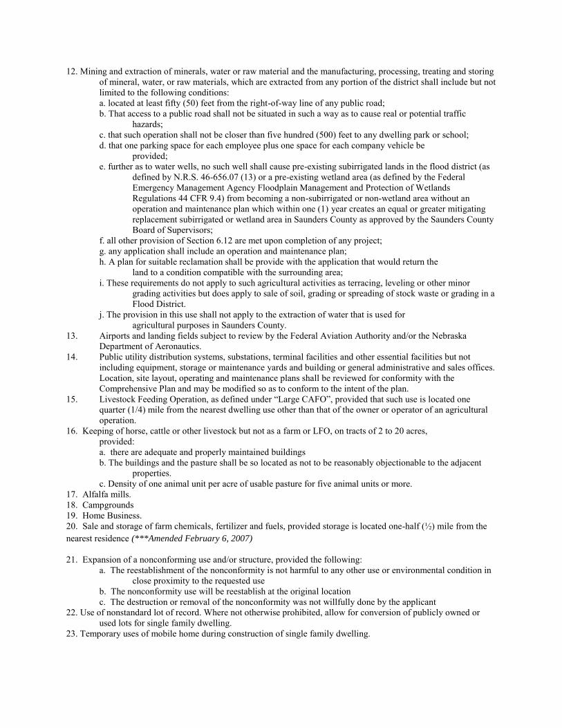
12. Mining and extraction of minerals, water or raw material and the manufacturing, processing, treating and storing of mineral, water, or raw materials, which are extracted from any portion of the district shall include but not limited to the following conditions: a. located at least fifty (50) feet from the right-of-way line of any public road; b. That access to a public road shall not be situated in such a way as to cause real or potential traffic
hazards; c. that such operation shall not be closer than five hundred (500) feet to any dwelling park or school; d. that one parking space for each employee plus one space for each company vehicle be
provided; e. further as to water wells, no such well shall cause pre-existing subirrigated lands in the flood district (as
defined by N.R.S. 46-656.07 (13) or a pre-existing wetland area (as defined by the Federal Emergency Management Agency Floodplain Management and Protection of Wetlands Regulations 44 CFR 9.4) from becoming a non-subirrigated or non-wetland area without an operation and maintenance plan which within one (1) year creates an equal or greater mitigating replacement subirrigated or wetland area in Saunders County as approved by the Saunders County Board of Supervisors;
f. all other provision of Section 6.12 are met upon completion of any project; g. any application shall include an operation and maintenance plan; h. A plan for suitable reclamation shall be provide with the application that would return the
land to a condition compatible with the surrounding area; i. These requirements do not apply to such agricultural activities as terracing, leveling or other minor
grading activities but does apply to sale of soil, grading or spreading of stock waste or grading in a Flood District.
j. The provision in this use shall not apply to the extraction of water that is used for agricultural purposes in Saunders County.
13. Airports and landing fields subject to review by the Federal Aviation Authority and/or the Nebraska Department of Aeronautics.
14. Public utility distribution systems, substations, terminal facilities and other essential facilities but not including equipment, storage or maintenance yards and building or general administrative and sales offices. Location, site layout, operating and maintenance plans shall be reviewed for conformity with the Comprehensive Plan and may be modified so as to conform to the intent of the plan.
15. Livestock Feeding Operation, as defined under “Large CAFO”, provided that such use is located one quarter (1/4) mile from the nearest dwelling use other than that of the owner or operator of an agricultural operation.
16. Keeping of horse, cattle or other livestock but not as a farm or LFO, on tracts of 2 to 20 acres, provided: a. there are adequate and properly maintained buildings b. The buildings and the pasture shall be so located as not to be reasonably objectionable to the adjacent
properties. c. Density of one animal unit per acre of usable pasture for five animal units or more.
17. Alfalfa mills. 18. Campgrounds 19. Home Business. 20. Sale and storage of farm chemicals, fertilizer and fuels, provided storage is located one-half (½) mile from the nearest residence (***Amended February 6, 2007)
21. Expansion of a nonconforming use and/or structure, provided the following: a. The reestablishment of the nonconformity is not harmful to any other use or environmental condition in
close proximity to the requested use b. The nonconformity use will be reestablish at the original location c. The destruction or removal of the nonconformity was not willfully done by the applicant
22. Use of nonstandard lot of record. Where not otherwise prohibited, allow for conversion of publicly owned or used lots for single family dwelling.
23. Temporary uses of mobile home during construction of single family dwelling.
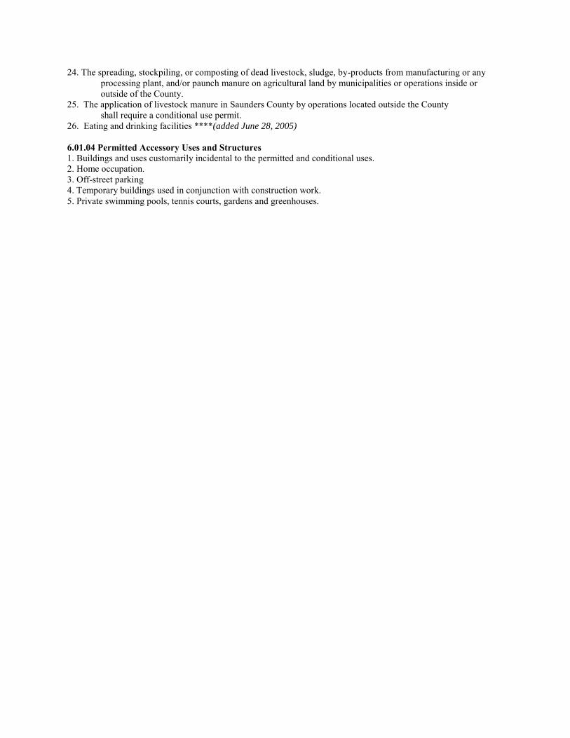
24. The spreading, stockpiling, or composting of dead livestock, sludge, by-products from manufacturing or any processing plant, and/or paunch manure on agricultural land by municipalities or operations inside or outside of the County.
25. The application of livestock manure in Saunders County by operations located outside the County shall require a conditional use permit.
26. Eating and drinking facilities ****(added June 28, 2005)
6.01.04 Permitted Accessory Uses and Structures 1. Buildings and uses customarily incidental to the permitted and conditional uses. 2. Home occupation. 3. Off-street parking 4. Temporary buildings used in conjunction with construction work. 5. Private swimming pools, tennis courts, gardens and greenhouses.
Metro Utilities District Platte West Wellhead Protection Plan 55
APPENDIX B Model Zoning Ordinance
State of Nebraska Well Head Protection Statutes and Model Well Head Protection Ordinance
WELLHEAD PROTECTION STATUTES
Below is a listing of Nebraska’s legislature statutes that allow local jurisdictions to protect public health and safety. NDEQ administers the wellhead protection program and provides technical assistance to any controlling entity designating a wellhead protection area and adopting controls to limit potential threats to the public water supply. The Nebraska Rural Water Association also can assist with wellhead protection in Nebraska. State statues and laws are summarized below. Sections 46-1501 to 46-1509 shall be known and may be cited as the Wellhead Protection Area Act. 46-1502 - Terms defined
For purposes of the Wellhead Protection Area Act:
(1) Controlling entity means a city, a village, a natural resources district, a rural water district, any other entity,
including, but not limited to, a privately owned public water supply system, or any combination thereof operating
under an agreement pursuant to the Interlocal Cooperation Act or the Joint Public Agency Act that operates a
public water supply system;
(2) Department means the Department of Environmental Quality;
(3) Director means the Director of Environmental Quality; and
(4) Wellhead protection area means the surface and subsurface area surrounding a water well or well field,
supplying a public water system, through which contaminants are reasonably likely to move toward and reach such
water well or well field.
46-1503 - Wellhead protection area; designation
Any controlling entity may designate a wellhead protection area and adopt controls pursuant to the Wellhead
Protection Area Act for the purpose of protecting the public water supply system. The department shall provide
technical assistance to any controlling entity designating a wellhead protection area and adopting controls pursuant
to the act.
46-1504 - Wellhead protection area designation; controlling entity; duties
Any controlling entity proposing to designate a wellhead protection area and adopt controls shall:
(1) Designate the boundaries of the wellhead protection area following the procedure in section 46-1505. The
wellhead protection area shall be based on all reasonably available hydrogeologic information on ground water
flow, recharge, and discharge and other related information necessary to adequately determine the wellhead
protection area for the purposes stated in this section;
(2) Identify within each proposed wellhead protection area all potential sources of contaminants which may have
any adverse effect on the health of persons;
(3) Describe a program that contains, as appropriate, technical assistance, financial assistance, implementation of
controls, education, training, and demonstration projects to protect the water supply within the wellhead protection
area from such contaminants;
(4) Include contingency plans for the location and provision of alternate drinking water supplies for each affected
public water supply system in the event of water well or well field contamination by such contaminants; and
(5) Propose the controls necessary to provide protection from contaminants which may have any adverse effect on
the health of persons served by the public water supply system of each participating controlling entity.
46-1505 - Proposed wellhead protection area; public notice and comment
The controlling entity shall publicize proposed boundaries for the wellhead protection area and the proposed
controls and shall provide time for public comment at one or more regularly scheduled public meetings of the
governing board of the controlling entity. Notice of the time for public comment shall be published in conjunction
with notice of such regularly scheduled meeting. A description of the proposed boundaries and the text of the
proposed controls shall be available at the office of the controlling entity for thirty days before such meeting.
Persons shall be given the opportunity to speak on the proposed designation and the proposed controls or to submit
written testimony for consideration by the controlling entity.
46-1506 - Boundaries of wellhead protection area; designation; procedure
Within sixty days after the last time for public comment under section 46-1505, the controlling entity shall make a
final designation of the boundaries of the wellhead protection area and the controls necessary to protect the water
in the wellhead protection area and shall submit them to the director for approval or disapproval. Such approval
shall be based on whether the boundaries of the wellhead protection area are reasonably defined, the controls are
reasonably related to the purpose of ground water protection in the area, and such approval is in the public interest.
The director shall act on the proposed designation of boundaries and proposed controls within ninety days after the
date the proposals are received by him or her.
If the director approves the proposed boundaries and controls, he or she shall so notify the controlling entity, but
the boundaries and controls shall not be deemed effective until the controlling entity has adopted such boundaries
and controls by ordinance or resolution. If the director disapproves either or both of the proposals, he or she shall
return the proposals to the controlling entity with an explanation of the reasons for such disapproval. The
controlling entity may revise such proposed designation of boundaries and proposed controls and, after notice and
hearing as provided for in the original proposed designation of boundaries and proposed controls, submit the
revised proposed designation of boundaries and proposed controls to the director for approval or disapproval.
If the director does not act on either the original or revised proposed designation of boundaries and proposed
controls within ninety days after submission by the controlling entity, the proposed designation of boundaries and
proposed controls shall be deemed approved by the director.
46-1507 - Existing wellhead protection areas; effect of act
Any wellhead protection area established before July 15, 1998, by resolution or ordinance of the controlling entity
need not be reestablished under the Wellhead Protection Area Act unless controls are proposed. If such controls are
proposed, the controls and the boundaries of the wellhead protection area are subject to the requirements of
sections 46-1504 to 46-1506. Any wellhead protection area purported to have been established before July 15, 1998,
other than by official action of a controlling entity shall be null and void beginning nine calendar months after July
15, 1998, unless reestablished by resolution or ordinance of the controlling entity.
46-1508 - Designated wellhead protection area; boundary area changes
A designated wellhead protection area may be amended as to boundaries and controls as provided for in the initial
designation of a wellhead protection area in the Wellhead Protection Area Act.
46-1509 - Environmental Quality Council; rules and regulations
The Environmental Quality Council shall adopt and promulgate rules and regulations to carry out the Wellhead
Protection Area Act.
MODEL ZONING ORDINANCE
ORDINANCE NO. ________
AN ORDINANCE TO PROVIDE FOR A WELLHEAD PROTECTION ZONE FOR THE CITY OF ________________, NEBRASKA IN ________________ COUNTY, NEBRASKA PURSUANT TO SECTION 17-536 OF THE REVISED STATUTES OF NEBRASKA BY ESTABLISHING LIMITATIONS UPON THE LOCATION OF POTENTIAL SOURCES OF POLLUTION OR INJURY TO THE MUNICIPAL WATER SUPPLY; TO ESTABLISH RULES AND REGULATIONS DEFINING AND ENFORCING SUCH LIMITATION; TO PROVIDE PROCEDURES FOR IMPLEMENTATION OF RULES AND REGULATIONS; TO PROVIDE FOR REPEAL OF ALL ORDINANCES OR PARTS OF ORDINANCES IN CONFLICT HEREWITH; AND TO PROVIDE FOR AN EFFECTIVE DATE.
WHEREAS, Section 17-536 of the Revised Statutes of Nebraska provides that the jurisdiction of the City to prevent pollution or injury to the source of its water supply shall extend 15 miles beyond its corporate limits;
WHEREAS, Section 46-1503 of the Nebraska Wellhead Protection Area Act in the Revised
Statutes of Nebraska provides that the City may designate a wellhead protection area and adopt controls pursuant to said Act for the protection of the public water supply system;
WHEREAS, pursuant to the Nebraska Wellhead Protection Act, Sections 46-1501 et. Seq. of the
Revised Statues of Nebraska, the Mayor and City Council has adopted the ________________ Wellhead Protection Plan;
WHEREAS, it is necessary to place limitations upon the location of potential sources of pollution
or injury to the municipal water supply and groundwater within the Wellhead Protection Area and to prescribe rules and regulations with respect to such limitation and the enforcement thereof;
WHEREAS, based on data collected by the City, the Nebraska Department of Environmental
Quality has conducted studies and prepared a map (Exhibit 1) reflecting recommended boundaries for the City of ________________ Wellhead Protection Area;
WHEREAS, ________________ County has no adopted zoning at the time of the enactment of
this ordinance, this ordinance shall be precedent; WHEREAS, the City of ________________ intends to enforce wellhead protection regulations of
the City to the extent of the boundary recommended by the Nebraska Department of Environmental Quality and has adopted a wellhead protection area map (Exhibit 1) as per Section _______ of the Municipal Code, as may be amended and which includes the following described real estate:
LEGAL DESCRIPTION:
NOW THEREFORE BE IT ORDAINED BY THE MAYOR AND COUNCIL OF THE CITY OF ________________, NEBRASKA:
Section 1 The findings set forth above are hereby made a part of this ordinance as fully as if set out at length herein.
Section 2 Words or phrases used in this ordinance shall be interpreted so as to give them the same meaning as they have in common usage and so as to give this ordinance its most reasonable application.
Section 3 The area inside the bold lines on the attached map (Exhibit 1, ________________ Wellhead Protection Area) and made part of this ordinance, shall be the official Wellhead Protection Area for the City of ________________, Nebraska. Section 4 It shall be unlawful for any person, other than the City of ________________, to place, install, construct or replace any of the following structures or conduct any of the following activities and those listed in Section 82-201 of the Municipal Code which has be designated by the City as a potential threat to the water supply within the Wellhead Protection Area(s) without the proper permit from the City of ________________, except as may be provided herein, to-wit: Activity or structure:
1) Non-potable water well 2) Sewage lagoon, or sludge or livestock manure storage and stockpiling 3) Absorption or disposal field for water or waste 4) Cesspool (prohibited under NDEQ Title 124, Chapter 1, Section 032) 5) Dumping grounds 6) Feedlot or feedlot runoff, or manure application 7) Livestock Pasture or Corral 8) Pit toilet (prohibited under NDEQ Title 124, Chapter 1, Section 032 9) Sanitary landfill 10) Chemical or petroleum product storage 11) Septic tank 12) Sewage treatment plant 13) Sewage wet well (prohibited under NDEQ Title 122, Chapter 3, Section 005) 14) Sanitary sewer connection 15) Sanitary sewer manhole 16) Sanitary sewer line 17) OTHERS
a. Potable water well b. Sandpoint well c. Feed mill d. Packing plant e. Fertilizer plant f. Anhydrous ammonia storage tank facilities or plants g. Fuel tank storage h. Gas Station i. Automotive service station j. Geothermal well and system
Section 5 The Department of Utilities and Public Works shall be responsible for implementation and enforcement of the rules and regulations established by this ordinance and shall consider all applications filed pursuant hereto. Such applications must be presented to the city council at any regular or special meeting. After reviewing the application of any person desiring to drill or operate any of the above-described facilities
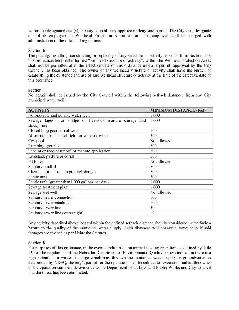
within the designated area(s), the city council must approve or deny said permit. The City shall designate one of its employees as Wellhead Protection Administrator. This employee shall be charged with administration of the rules and regulations. Section 6 The placing, installing, constructing or replacing of any structure or activity as set forth in Section 4 of this ordinance, hereinafter termed “wellhead structure or activity”, within the Wellhead Protection Areas shall not be permitted after the effective date of this ordinance unless a permit, approved by the City Council, has been obtained. The owner of any wellhead structure or activity shall have the burden of establishing the existence and use of said wellhead structure or activity at the time of the effective date of this ordinance. Section 7 No permit shall be issued by the City Council within the following setback distances from any City municipal water well: ACTIVITY MINIMUM DISTANCE (feet) Non-potable and potable water well 1,000 Sewage lagoon, or sludge or livestock manure storage and stockpiling
1,000
Closed loop geothermal well 100 Absorption or disposal field for water or waste 500 Cesspool Not allowed Dumping grounds 500 Feedlot or feedlot runoff, or manure application 500 Livestock pasture or corral 500 Pit toilet Not allowed Sanitary landfill 500 Chemical or petroleum product storage 500 Septic tank 500 Septic tank (greater than1,000 gallons per day) 1,000 Sewage treatment plant 1,000 Sewage wet well Not allowed Sanitary sewer connection 100 Sanitary sewer manhole 100 Sanitary sewer line 50 Sanitary sewer line (water tight) 10 Any activity described above located within the defined setback distance shall be considered prima facie a hazard to the quality of the municipal water supply. Such distances will change automatically if said footages are revised as per Nebraska Statutes. Section 8 For purposes of this ordinance, in the event conditions at an animal feeding operation, as defined by Title 130 of the regulations of the Nebraska Department of Environmental Quality, shows indication there is a high potential for waste discharge which may threaten the municipal water supply or groundwater, as determined by NDEQ, the city’s permit for the operation shall be subject to revocation, unless the owner of the operation can provide evidence to the Department of Utilities and Public Works and City Council that the threat has been eliminated.
Section 9 Any wellhead structure or activity, not prohibited by Section 7 above, shall be allowed upon determination by City that such activity does not constitute a hazard or threat to the quality of the municipal water supply and upon issuance of a permit by the City. Section 10 Prior to placing, installing, constructing, expanding or replacing any wellhead structure or activity, the owner of the real estate upon which the structure or activity is proposed shall file with the Administrator an application for a wellhead structure or activity permit. Said application shall be on a form furnished by the Administrator and shall include supporting information indicating why approval would not adversely impact the quality of the City’s municipal water supply or groundwater. The Administrator shall thereafter submit the application to the City Council for consideration. Prior to acting upon such application, the City Council may refer back to the Department of Utilities and Public Works or may seek an engineering report, recommendations of the Lower Elkhorn Natural Resources District, the Nebraska Department of Environmental Quality or any other party or agency in evaluating the impact of the proposed structure or activity on the quality of the municipal water supply. A permit shall only be issued if it is determined the structure or activity is unlikely to contaminate or pollute the water supply. In the event that the wellhead structure or activity is closed for more than one year and re-opened, the owner-operator shall re-apply for a new permit. Section 11 Wellhead structures or activities in existence and use in the Wellhead Protection Area as of the effective date of this ordinance shall continue to be permitted unless such continued existence or use, in the opinion of the Department of Utilities and Public Works, presents a hazard to the quality of the municipal water supply or groundwater. If the Department of Utilities and Public Works determines an existing wellhead structure or activity presents a water quality hazard, the Department of Utilities and Public Works shall authorize the Administrator to notify the owner of the structure or activity to cease and desist said structure or activity. If the owner of the wellhead structure or activity desires to continue operation of said structure or activity, the owner may seek to procure a permit pursuant to this ordinance. If the owner does not cease and desist pursuant to such notice, the Administrator may proceed pursuant to Section 12 of this ordinance against said owner and/or the wellhead structure or activity. Section 12 Any person found violating any provision of this ordinance shall be subject to a fine not to exceed $100.00. The continuation of a violation of this ordinance shall be deemed an additional crime for every 24 hours of such continued violation. In addition, the City may obtain injunctive relief and sue for damages and remediation, and pursue any other remedy available to it under the laws of the State of Nebraska or other authority having jurisdiction over such matters. (Section 82-205 of the Municipal Code) Section 13 Should any section, paragraph, sentence or word of this ordinance hereby adopted be declared, for any reason, to be invalid, it is the intent of the Mayor and City Council of the City of ________________, Nebraska, that it would have passed all other portions of this ordinance independent of the elimination hereof of any such portion as may be declared invalid. Section 14 All ordinances or parts of ordinances in conflict with the provisions of this ordinance are hereby repealed.
City of ________________, Nebraska – Wellhead Protection Ordinance – _____________, 2013 - DRAFT 1
MODEL ZONING ORDINANCE Note: this model ordinance intends to limit or prohibit specific uses and activities within a close proximity to a public well(s) providing potable water.
ORDINANCE NO. ________ AN ORDINANCE TO PROVIDE FOR A WELLHEAD PROTECTION ZONE FOR THE CITY OF ________________, NEBRASKA IN ________________ COUNTY, NEBRASKA PURSUANT TO SECTION 17-536 OF THE REVISED STATUTES OF NEBRASKA BY ESTABLISHING LIMITATIONS UPON THE LOCATION OF POTENTIAL SOURCES OF POLLUTION OR INJURY TO THE MUNICIPAL WATER SUPPLY; TO ESTABLISH RULES AND REGULATIONS DEFINING AND ENFORCING SUCH LIMITATION; TO PROVIDE PROCEDURES FOR IMPLEMENTATION OF RULES AND REGULATIONS; TO PROVIDE FOR REPEAL OF ALL ORDINANCES OR PARTS OF ORDINANCES IN CONFLICT HEREWITH; AND TO PROVIDE FOR AN EFFECTIVE DATE.
WHEREAS, Section 46-1503 of the Nebraska Wellhead Protection Area Act in the Revised Statutes of Nebraska provides that the ________ may designate a wellhead protection area and adopt controls pursuant to said Act for the protection of the public water supply system;
WHEREAS, pursuant to the Nebraska Wellhead Protection Act, Sections 46-1501 et. Seq. of the
Revised Statues of Nebraska, the controlling entity has adopted the ________________ Wellhead Protection Plan;
WHEREAS, it is necessary to place limitations upon the location of potential sources of pollution or
injury to the municipal water supply and groundwater within the Wellhead Protection Area and to prescribe rules and regulations with respect to such limitation and the enforcement thereof;
WHEREAS, the Nebraska Department of Environmental Quality has analyzed available data and
prepared a map (Exhibit 1) reflecting recommended boundaries for the City of ________________ Wellhead Protection Area;
WHEREAS, the ________________ intends to enforce wellhead protection regulations of the
________ to the extent of the boundary recommended by the Nebraska Department of Environmental Quality and has adopted a wellhead protection area map (Exhibit 1) as per Section _______ of the Code, as may be amended and which includes the following described real estate:
LEGAL DESCRIPTION:
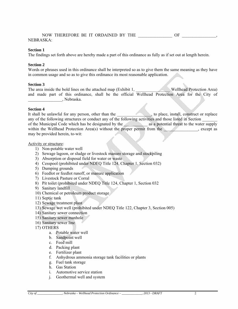
City of ________________, Nebraska – Wellhead Protection Ordinance – _____________, 2013 - DRAFT 2
NOW THEREFORE BE IT ORDAINED BY THE ________________ OF ________________,
NEBRASKA:
Section 1 The findings set forth above are hereby made a part of this ordinance as fully as if set out at length herein. Section 2 Words or phrases used in this ordinance shall be interpreted so as to give them the same meaning as they have in common usage and so as to give this ordinance its most reasonable application.
Section 3 The area inside the bold lines on the attached map (Exhibit 1, ________________ Wellhead Protection Area) and made part of this ordinance, shall be the official Wellhead Protection Area for the City of ________________, Nebraska. Section 4 It shall be unlawful for any person, other than the ________________, to place, install, construct or replace any of the following structures or conduct any of the following activities and those listed in Section _______ of the Municipal Code which has be designated by the ___________ as a potential threat to the water supply within the Wellhead Protection Area(s) without the proper permit from the ________________, except as may be provided herein, to-wit: Activity or structure:
1) Non-potable water well 2) Sewage lagoon, or sludge or livestock manure storage and stockpiling 3) Absorption or disposal field for water or waste 4) Cesspool (prohibited under NDEQ Title 124, Chapter 1, Section 032) 5) Dumping grounds 6) Feedlot or feedlot runoff, or manure application 7) Livestock Pasture or Corral 8) Pit toilet (prohibited under NDEQ Title 124, Chapter 1, Section 032 9) Sanitary landfill 10) Chemical or petroleum product storage 11) Septic tank 12) Sewage treatment plant 13) Sewage wet well (prohibited under NDEQ Title 122, Chapter 3, Section 005) 14) Sanitary sewer connection 15) Sanitary sewer manhole 16) Sanitary sewer line 17) OTHERS
a. Potable water well b. Sandpoint well c. Feed mill d. Packing plant e. Fertilizer plant f. Anhydrous ammonia storage tank facilities or plants g. Fuel tank storage h. Gas Station i. Automotive service station j. Geothermal well and system
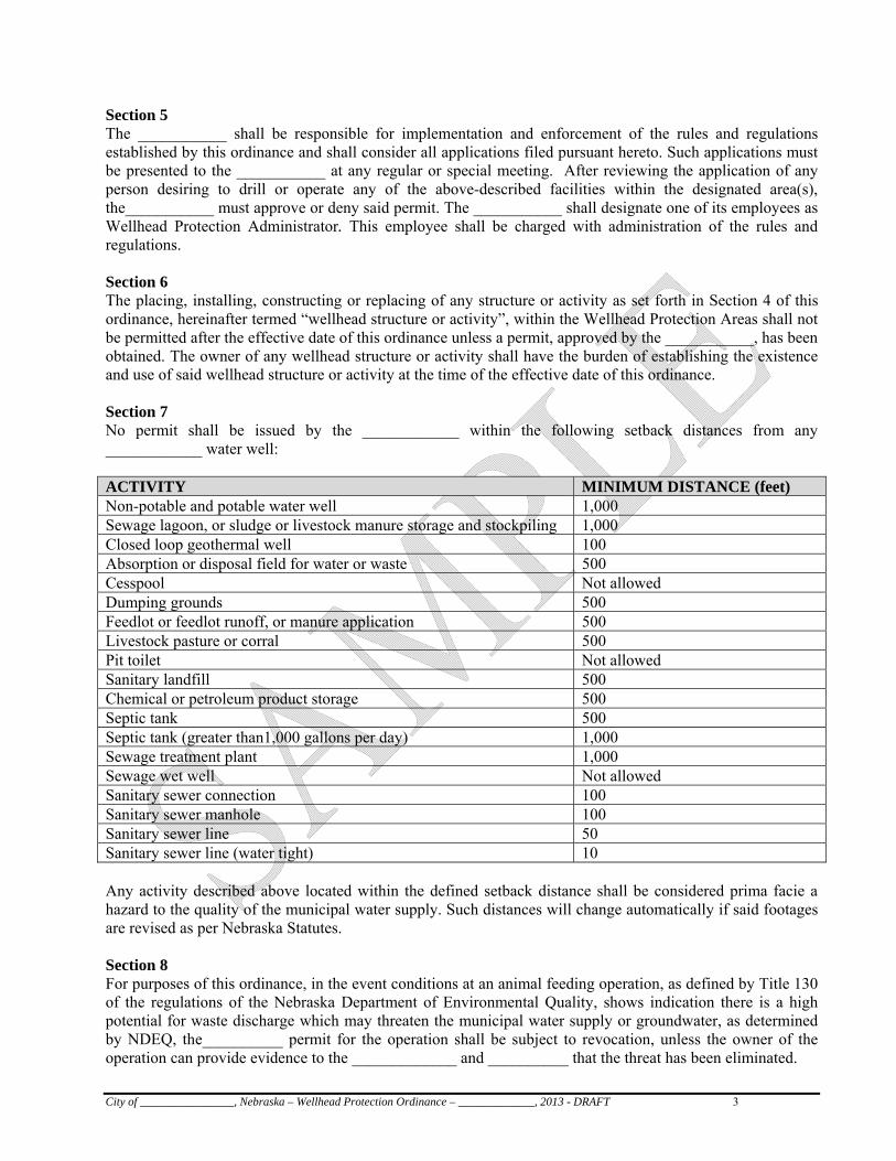
City of ________________, Nebraska – Wellhead Protection Ordinance – _____________, 2013 - DRAFT 3
Section 5 The ___________ shall be responsible for implementation and enforcement of the rules and regulations established by this ordinance and shall consider all applications filed pursuant hereto. Such applications must be presented to the ___________ at any regular or special meeting. After reviewing the application of any person desiring to drill or operate any of the above-described facilities within the designated area(s), the___________ must approve or deny said permit. The ___________ shall designate one of its employees as Wellhead Protection Administrator. This employee shall be charged with administration of the rules and regulations. Section 6 The placing, installing, constructing or replacing of any structure or activity as set forth in Section 4 of this ordinance, hereinafter termed “wellhead structure or activity”, within the Wellhead Protection Areas shall not be permitted after the effective date of this ordinance unless a permit, approved by the ___________, has been obtained. The owner of any wellhead structure or activity shall have the burden of establishing the existence and use of said wellhead structure or activity at the time of the effective date of this ordinance. Section 7 No permit shall be issued by the ____________ within the following setback distances from any ____________ water well: ACTIVITY MINIMUM DISTANCE (feet) Non-potable and potable water well 1,000 Sewage lagoon, or sludge or livestock manure storage and stockpiling 1,000 Closed loop geothermal well 100 Absorption or disposal field for water or waste 500 Cesspool Not allowed Dumping grounds 500 Feedlot or feedlot runoff, or manure application 500 Livestock pasture or corral 500 Pit toilet Not allowed Sanitary landfill 500 Chemical or petroleum product storage 500 Septic tank 500 Septic tank (greater than1,000 gallons per day) 1,000 Sewage treatment plant 1,000 Sewage wet well Not allowed Sanitary sewer connection 100 Sanitary sewer manhole 100 Sanitary sewer line 50 Sanitary sewer line (water tight) 10 Any activity described above located within the defined setback distance shall be considered prima facie a hazard to the quality of the municipal water supply. Such distances will change automatically if said footages are revised as per Nebraska Statutes. Section 8 For purposes of this ordinance, in the event conditions at an animal feeding operation, as defined by Title 130 of the regulations of the Nebraska Department of Environmental Quality, shows indication there is a high potential for waste discharge which may threaten the municipal water supply or groundwater, as determined by NDEQ, the__________ permit for the operation shall be subject to revocation, unless the owner of the operation can provide evidence to the _____________ and __________ that the threat has been eliminated.
City of ________________, Nebraska – Wellhead Protection Ordinance – _____________, 2013 - DRAFT 4
Section 9 Any wellhead structure or activity, not prohibited by Section 7 above, shall be allowed upon determination by ___________ that such activity does not constitute a hazard or threat to the quality of the municipal water supply and upon issuance of a permit by the ___________. Section 10 Prior to placing, installing, constructing, expanding or replacing any wellhead structure or activity, the owner of the real estate upon which the structure or activity is proposed shall file with the Administrator an application for a wellhead structure or activity permit. Said application shall be on a form furnished by the Administrator and shall include supporting information indicating why approval would not adversely impact the quality of the ____________ water supply or groundwater. The Administrator shall thereafter submit the application to the ____________ for consideration. Prior to acting upon such application, the ___________ may refer back to the Department of Utilities and Public Works or may seek an engineering report, recommendations of the Natural Resources District, the Nebraska Department of Environmental Quality or any other party or agency in evaluating the impact of the proposed structure or activity on the quality of the municipal water supply. A permit shall only be issued if it is determined the structure or activity is unlikely to contaminate or pollute the water supply. In the event that the wellhead structure or activity is closed for more than one year and re-opened, the owner-operator shall re-apply for a new permit. Section 11 Wellhead structures or activities in existence and use in the Wellhead Protection Area as of the effective date of this ordinance shall continue to be permitted unless such continued existence or use, in the opinion of the Department of Utilities and Public Works, presents a hazard to the quality of the municipal water supply or groundwater. If the Department of Utilities and Public Works determines an existing wellhead structure or activity presents a water quality hazard, the Department of Utilities and Public Works shall authorize the Administrator to notify the owner of the structure or activity to cease and desist said structure or activity. If the owner of the wellhead structure or activity desires to continue operation of said structure or activity, the owner may seek to procure a permit pursuant to this ordinance. If the owner does not cease and desist pursuant to such notice, the Administrator may proceed pursuant to Section 12 of this ordinance against said owner and/or the wellhead structure or activity. Section 12 Any person found violating any provision of this ordinance shall be subject to a fine not to exceed $100.00. The continuation of a violation of this ordinance shall be deemed an additional crime for every 24 hours of such continued violation. In addition, the___________ may obtain injunctive relief and sue for damages and remediation, and pursue any other remedy available to it under the laws of the State of Nebraska or other authority having jurisdiction over such matters. (Section __________ of the Code) Section 13 Should any section, paragraph, sentence or word of this ordinance hereby adopted be declared, for any reason, to be invalid, it is the intent of the ____________and ___________ of the ________________, Nebraska, that it would have passed all other portions of this ordinance independent of the elimination hereof of any such portion as may be declared invalid. Section 14 All ordinances or parts of ordinances in conflict with the provisions of this ordinance are hereby repealed. Section 15 This ordinance shall be in full force and effect from and after its passage, approval and publication according to law.
City of ________________, Nebraska – Wellhead Protection Ordinance – _____________, 2013 - DRAFT 5
PASSED AND APPROVED this day of , 20__. (Seal) ________________, ________________ COUNTY, NE Title Attest: Clerk
Metro Utilities District Platte West Wellhead Protection Plan 56
APPENDIX C Water Operations Emergency Plan
METROPOLITAN UTILITIES DISTRICT
OF OMAHA
WATER OPERATIONS
EMERGENCY PLAN
Limited Distribution Contains Sensitive Security Information
June 2012
Metro Utilities District Platte West Wellhead Protection Plan 57
APPENDIX D Spills into the Missouri or Platte River
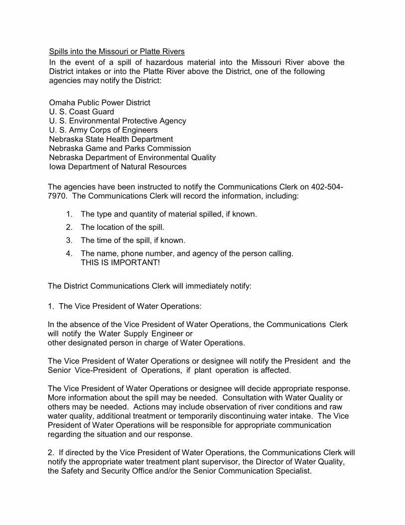
Spills into the Missouri or Platte Rivers In the event of a spill of hazardous material into the Missouri River above the District intakes or into the Platte River above the District, one of the following agencies may notify the District:
Omaha Public Power District U. S. Coast Guard U. S. Environmental Protective Agency U. S. Army Corps of Engineers Nebraska State Health Department Nebraska Game and Parks Commission Nebraska Department of Environmental Quality Iowa Department of Natural Resources The agencies have been instructed to notify the Communications Clerk on 402-504-7970. The Communications Clerk will record the information, including:
1. The type and quantity of material spilled, if known.
2. The location of the spill.
3. The time of the spill, if known.
4. The name, phone number, and agency of the person calling. THIS IS IMPORTANT!
The District Communications Clerk will immediately notify: 1. The Vice President of Water Operations: In the absence of the Vice President of Water Operations, the Communications Clerk will notify the Water Supply Engineer or other designated person in charge of Water Operations. The Vice President of Water Operations or designee will notify the President and the Senior Vice-President of Operations, if plant operation is affected. The Vice President of Water Operations or designee will decide appropriate response. More information about the spill may be needed. Consultation with Water Quality or others may be needed. Actions may include observation of river conditions and raw water quality, additional treatment or temporarily discontinuing water intake. The Vice President of Water Operations will be responsible for appropriate communication regarding the situation and our response. 2. If directed by the Vice President of Water Operations, the Communications Clerk will notify the appropriate water treatment plant supervisor, the Director of Water Quality, the Safety and Security Office and/or the Senior Communication Specialist.
Metro Utilities District Platte West Wellhead Protection Plan 58
APPENDIX E MUD Water Conservation and Alert Plan
September 2012 Page 1 of 11
Water Conservation and Alert Plan
September 2012 Page 2 of 11
Metropolitan Utilities District Water Conservation Plan
September 2012 Goal The goal of the Water Conservation Plan is to promote the wise use of water through public education programs, rate structure and operating plans and to assure our customers receive safe water in sufficient quantity and quality to serve their needs. General Discussion Our community is fortunate to be located near two reliable sources of water; the Missouri and Platte Rivers. M.U.D. has about one-half of our production total from each river. The Florence Water Treatment Plant, located on the banks of the Missouri River, has a capacity of 158 million gallons per day. This is more than enough water to meet our customers’ average daily usage of 90 to 100 million gallons per day. The Corps of Engineers regulates the Missouri River flow. The minimum sustained flow in the river is 8,000 cubic feet per second. At this rate, an amount of water equivalent to the daily plant capacity flows by M.U.D.’s intakes every 44 minutes. The Platte South Water Treatment Plant is located in Sarpy County on the Platte River. While the Platte River is more susceptible to low flows caused by a drought, as long as there is some flow in the river, the plant can produce near its 60 million gallons per day capacity. The Platte West Water Treatment Plant is located in Douglas County with well fields along the Platte River in both Douglas and Saunders Counties. The plant can produce 100 million gallons per day capacity. Water supplies are reliable. The chance of experiencing a long-term water shortage is remote. A possibility does exist, however, for short-term water shortages. These could be drought-related, caused by limited plant or distribution system capacities or due to any number of emergency situations. If water demands exceed available production for any reason, it may be necessary to implement water use restrictions. M.U.D. must not lose sight of the fact that it does share the natural resources of the rivers with other users and there may be conditions in which the wise use of water would benefit those users. M.U.D. has and will continue to support all types of water conservation measures. Benefits There are many benefits that can be derived from the wise use of water both for M.U.D. and for our customers. Our customers benefit by receiving lower bills – the result of
September 2012 Page 3 of 11
using less water and possibly delaying capital expenditures. We all benefit by conserving natural resources and by having a safe, reliable supply of water to our community. Public Education Plan The Education Plan promotes the overall wise use of water and encourages water conservation during peak usage periods and will familiarize our customers with the Water Conservation Plan. The audience for the Education Plan is residential, commercial and industrial customers, school-aged children, government officials, and regulators. Specific items in the Public Education Plan include:
Wise water use messages on customer bills and wise water use tips in customer newsletters Wise water use messages on our “on-hold” customer voice message system. Sponsor a wise water use flower garden at the Village Pointe Shopping Center in conjunction with the UNL Extension Office and Master Gardeners. A Water Conservation section on our website at www.mudomaha.com, which also includes wise water use tips, charts, statistics and links to helpful resources. “Make Every Drop Count” rain gauges and moisture sensors are distributed to customers at community events. New customer booklet section with an extensive list of water conservation tips. Our Employee Speakers Bureau presented more than 100 programs during the past year, reaching nearly 200,000 members of the community through civic groups, schools, and water plant tours. Through ESB, we have a water mascot called “Thirstin,” to promote wise water use in classrooms and at community events. For the 23rd consecutive year, we participated in the Annual “Eyes on Conservation” Water Festival, held in the spring at Schramm Park. The Festival attracts approximately 1,600 fifth grade students. We distributed “Make Every Drop Count” water conservation wheels to people attending community events, such as World of Water! and the Omaha Safety Council Exposition.
September 2012 Page 4 of 11
We created two videos, “Trip Behind Your Water Faucet” and “Wise Use of Resources,” which include wise water use messages. These videos are used in Speakers Bureau presentations and copies were distributed to area libraries. We have scheduled individual meetings with editors and reporters of the daily newspaper, two radio stations and four television stations so they could get to know our people and our operations. We also have given tours of our facilities, prior to any news event, for information purposes.
September 2012 Page 5 of 11
Water Conservation Measures Since 1979, M.U.D.’s rate structure has been designed to encourage water conservation. During the summer months, when usage is at its peak, the majority of M.U.D.’s customers are under an increasing block rate structure. This type of rate encourages conservation by charging a higher rate as the water usage is increased. This is the most effective way of using rates to encourage water conservation. M.U.D. has also created a separate rate category for customers with a high peak usage factor. Customers who use water for commercial and industrial sprinkling, lake-recharge and cooling pay a higher rate to help compensate for the increased peak load. This encourages these heavy users to pay closer attention to how often and when they use water. M.U.D. has an understandable water bill with water consumption and cost clearly identified. We also have regular meter readings so seasonal use can be identified. M.U.D. has universal metering including public use. Meters are regularly tested and calibrated, repaired, or replaced to maintain accuracy. Water loss is minimized by regular leak surveys and leak repairs. We utilize pressure management techniques including use of pressure reducing valves within selected areas of the water distribution system. M.U.D. promotes landscape efficiency with projects such as the wise water use garden at the Village Pointe Shopping Center and other public education presentations. We use supply side technologies such as chemical-efficient split treatment and natural gas energy management to reduce peak electrical demands. We support demand side technologies by educating our customers about wise water use and supporting the use of water-efficient plumbing.
September 2012 Page 6 of 11
Water Conservation Emergency Operation Plan The responsibility for calling for these alerts will be with the President and will be based on consultations with the Senior Vice President of Operations and with the Vice President of Water Operations. Once the decision has been made, it will be the responsibility of the Senior Vice President, Chief Customer Officer and the Director of Corporate Communication to make the appropriate notification to the news media. All of the following actions or restrictions may only be required in certain sections of the system, depending on circumstances. In this case the press releases will include a delineation of the restricted area.
September 2012 Page 7 of 11
Level 1 Water Alert (Voluntary Alternate Day Watering) Trigger:
Water Consumption reaches 95% (about 300 million gallons per day) of available supply or system capacity, or any of the water storage reservoirs cannot be refilled from day to day, or low pressure jeopardizes fire fighting or causes numerous customer complaints.
Action:
The M.U.D. Director of Corporate Communication will issue a press release notifying the public that we are issuing the alert. The press release will include a basic list of water conservation tips. M.U.D. will limit hydrant flushing and main filling, comply with alternate day water restrictions, and shut down decorative fountains at the Florence Plant and the Headquarters Building. All customers will be asked to voluntarily adhere to alternate day watering. Customers will be asked to water no more often than every other day. If possible, customers should water every third or fourth day. Customers may use their own discretion regarding which days they water and which days they refrain from watering. Customers will be told what to expect if a level 2 alert is issued. All customers will be asked to voluntarily discontinue hosing down driveways, shut off decorative fountains, discontinue filling swimming pools, and other actions deemed appropriate by M.U.D. The City of Omaha and other municipalities served by M.U.D. will be asked to voluntarily comply with alternate day watering restrictions, curtail sewer flushing, lake filling, fire fighting drills, street washing and other non-essential uses of water.
Enforcement: There will be no enforcement at this level.
September 2012 Page 8 of 11
Level 2 Water Alert (Voluntary No-Watering Days) Purpose:
Specified no-watering days will allow M.U.D. to fill the water system reservoirs. Trigger: Water Consumption reaches 95% of available supply or system capacity, or any of the water storage reservoirs cannot be refilled from day to day, or low pressure jeopardizes fire fighting or causes numerous customer complaints. Action:
The M.U.D. Director of Corporate Communication will issue a press release notifying the public that we are issuing the alert. The press release will include a basic list of water conservation tips. M.U.D. will limit hydrant flushing and main filling, comply with no-watering day restrictions, and shut down decorative fountains the Florence Plant and the Headquarters Building. All customers will be asked to voluntarily discontinue all outdoor uses of water on specified days. The days will be determined by M.U.D. at the time the alert is issued. They will allow one full day after the press release for notification. All customers will be asked to voluntarily discontinue hosing down driveways, shut off decorative fountains, discontinue filling swimming pools, and other actions deemed appropriate by M.U.D. The City of Omaha and other municipalities served by M.U.D. will be asked to voluntarily comply with no-watering day restrictions, curtail sewer flushing, lake filling, fire fighting drills, street washing and other non-essential uses of water.
Enforcement: There will be no enforcement at this level.
September 2012 Page 9 of 11
Level 3 Water Alert (Mandatory) Trigger: Water Consumption meets or exceeds available supply or system capacity, or useable water storage has been reduced 50%, or there are widespread pressure problems. Action:
The M.U.D. Director of Corporate Communication will issue a press release notifying the public that the voluntary requirements of the Level 1 or Level 2 water alerts have become mandatory. M.U.D. will stop hydrant flushing and main filling, comply with designated restrictions, including shut down decorative fountains at the Florence Plant and the Headquarters Building. All customers will be required to adhere to watering restrictions. All customers will be required to discontinue hosing down driveways, shut off decorative fountains, discontinue filling swimming pools, and other actions deemed appropriate by M.U.D. The City of Omaha and other municipalities served by M.U.D. will be required to comply with watering restrictions, stop sewer flushing, lake filling, fire fighting drills, street washing and other non-essential uses of water.
Enforcement:
Customers who do not comply with the watering restrictions will be subject to having their water shut off until mandatory restrictions are lifted. The current turn-on fee will be charged to restore service.
Exceptions:
Circumstances sometimes dictate that customers must water on designated non-watering days. Exceptions may be made for new sod less than three weeks old and other circumstances deemed appropriate by M.U.D.
September 2012 Page 10 of 11
Level 4 Water Emergency (Water Quantity) Trigger:
Water usage exceeds production or distribution capacity due to emergency situations.
Action:
The M.U.D. Director of Corporate Communications will issue a press release notifying the public that a Water Emergency is in effect. All non-sanitary, non-essential use of water must be discontinued.
Enforcement:
Customers who do not comply with the watering restrictions will be subject to having their water shut off until the Water Emergency is lifted. The current turn-on fee will be charged to restore service.
September 2012 Page 11 of 11
Level 5 Water Quality Emergency Trigger:
Water quality for human consumption cannot be assured due to a contamination or suspected contamination.
Action:
The M.U.D. Director of Corporate Communications will issue a press release notifying the public that the water cannot be consumed safely unless it is boiled or cannot be consumed safely at all. This will include water used in food preparation. M.U.D., in cooperation with the State of Nebraska Health and Human Services Department, will take action to make the water safe for consumption and conduct tests to assure it is safe. M.U.D. will issue a press release informing customers the water is now safe for consumption.
Enforcement: None.
Metro Utilities District Platte West Wellhead Protection Plan 59
APPENDIX F Public Involvement Materials
MUD Wellhead Protection Planning Platte West Well Field – Advisory Group Meeting 1 Wednesday, April 17, 2013 Platte West Water Treatment Plant 7:00 pm – 9:00 pm Attendees: Dave Brakenhoff, Western Sand & Gravel Co. Russ Iwan, MUD Brian Buckingham, Western Sand & Gravel Co. Jeff Ray, JEO Ryan Chapman, NDEQ Brian Henkel, P-MRNRD Brian Vencil, Farmer/Landowner Mike Heldt, Farmer/Landowner George Borreson, Saunders County Steve Huggenberger, City of Lincoln
Doug Cook, Douglas County Carol White, Lyman-Richey Corp. Mike Carrick, NGPC-2 Rivers State Park Larry Angle, Lower Platte South NRD Marlin Petermann, P-MRNRD Kevin Tobin, MUD Scott Keep, MUD Joel Christensen, MUD Luca DeAngelis, HDR Stephen Sykes, HDR
Agenda:
I. Introductions of Project Staff II. Introductions of Advisory Group
a. Name b. Affiliation c. What you hope to get out of this process
III. Wellhead Protection Plan Presentation a. Goals of the Wellhead Protection Plan b. Stakeholder Engagement Process and Review of Advisory Group
Involvement Expectations c. Role of the Advisory Group d. Provide input on the Plan
i. If you have input, provide written communication to Luca DeAngelis (see below) by the end of April
IV. Next Meeting – Tuesday, June 4, 7:00 pm – 9:00 pm, same location a. HDR will present technical portions of the Plan
V. Questions/Closing Comments
Notes: After a PowerPoint presentation by DeAngelis, the discussion was opened to the group for questions and comments on the Plan process and information gathered to date. (The PowerPoint accompanies these notes for Advisory Group members to use as a reference.)
• Petermann asked how surface water of the Platte affects groundwater in terms of this particular project. DeAngelis responded that this Wellhead Protection Plan is going to incorporate contingency planning for pollution from the river.
• DeAngelis mentioned that a draft Wellhead Protection Plan would be provided to this group prior to the Advisory Group meeting in June. The Plan will be available to the public in July for review. The Plan is scheduled to be reviewed by the MUD Board and approved at their Board meeting in August.
• A question was asked related to other wellhead plans that address agricultural chemicals such as nitrates; is there an issue with nitrates that we need to be concerned about? The general consensus from MUD, NDEQ, and NRD staff was that in some areas and at certain times of the year there are problems with water quality due to nitrates.
o LPNNRD staff have offered to assist with low cost seed for winter crops to address spring fertilization runoff.
o Chapman mentioned that they are working on areas with nitrate problems. NDEQ has a land use assessment program to understand if changing irrigation practices may help. A land use map could help the group better understand this.
o Chapman asked if we can color code the regulated facilities to break the maps down further for the next Advisory Group meeting.
• Advisory Group members are not required to attend the MUD Board meeting, where the public is likely to comment, but all are welcome and encouraged to attend. MUD staff encourage Advisory Group members to act as representatives and community educators regarding the Wellhead Protection Plans.
• MUD staff encouraged all Advisory Group members to share their comments and concerns during this meeting so the Plan can represent all stakeholders.
• P-MRNRD and NDEQ staff indicated that there is assistance available to landowners for well decommissioning. MUD staff said that depending on scope and costs there may be assistance available from MUD. Chapman mentioned that state regulations related to well decommissioning may be changing soon and will likely make it more expensive to decommission in the future.
• During the planning and design phases for the Platte West Water facility there was extensive research into the locations of existing wells. Many abandoned wells were found in the project area. Chapman added that based on experience at NDEQ, there are likely twice as many abandoned wells compared to what the maps represent.
• The group discussion moved to potential state or local regulation as a result of the Wellhead Protection Plan development. Chapman explained that he doesn’t see regulation coming from the State on these Plans. Rather, experience has shown that local entities have grouped together to establish an interlocal agreement or overlay. Chapman used the example of a mutually agreeable zoning overlay that addresses groundwater and wellhead protection
between three NRD’s, four counties, and the city of Creighton, NE. Ray explained that a zoning overlay is adopted by the county and forwarded to the NRD’s for support. Chapman added that Fremont has an overlay zone that addresses the number of feedlots allowed. Additional examples of overlay restrictions include restricting the depth of certain activities or development from groundwater levels. Chapman added that a housing development in Saunders County has language that requires the monitoring of potential wastewater leaks from the residential area that could impact the wellhead protection zone. Cook added that Washington County has wellhead protection plan zoning regulations in their code. Ray explained that in some counties there is language in their code that addresses the future establishment of protection areas.
• The Advisory Group discussed highway signs that read “Entering Groundwater Area.” Chapman described the signs as good tools to raise public awareness of the potential impacts to groundwater supply areas. In the event of a hazardous spill on a roadway the signs can remind first responders that they need to contact NDEQ and any water providers in the area. There was general support for posting these signs once the Plan is adopted.
• Iwan mentioned that if Advisory Group members were interested there could be a brief tour of the water facility before the next meeting.
• White asked if a list of Advisory Group members can be sent out to group members. MUD staff responded that this is possible.
• Brakenhoff asked if there are any known negative impacts to ground water quality from their gravel operations or if there is an expectation of future setback requirements. Tobin said that MUD is not aware of any current challenges or any plans to change setback requirements.
• Regarding the boundaries of the wellhead protection zone, there was discussion related to how the area was established and whether NDEQ established the area. Chapman explained that the area has been defined for a few years based on the results of groundwater modeling and that NDEQ would consider adding or removing a segment of the proposed area if there was a compelling reason.
• Chapman suggested that the Plan describe MUD’s surface water rights to help explain the distinction between groundwater resources and surface water resources.
• The meeting was ended with words of thanks and appreciation for the Advisory Group members’ time and commitment to working with MUD on the development of this Plan.
MUD Wellhead Protection Planning Platte West Well Field – Advisory Group Meeting 2 Tuesday, June 4, 2013 Platte West Water Treatment Plant Plant Tour: 6:30 p.m. – 7:00 p.m. Meeting: 7:00 p.m. – 9:00 p.m. Attendees: Dave Brakenhoff, Western Sand & Gravel Co. Brian Buckingham, Western Sand & Gravel Co. Brian Henkel, P‐MRNRD Brian Vencil, Farmer/Landowner George Borreson, Saunders County Bret Schomer, LPNNRD Megan Sittler, LPRCA Carol White, Lyman‐Richey Corp. Mike Carrick, NGPC‐2 Rivers State Park Marlin Petermann, P‐MRNRD Russ Iwan, MUD
Kevin Tobin, MUD Scott Keep, MUD Joel Christensen, MUD Ryan Chapman, NDEQ Luca DeAngelis, HDR Jeff Ray, JEO Stephen Sykes, HDR Bob Roos, Lyman‐Richey Corp. Jerry Obrist, City of Lincoln‐Lincoln Water System
Agenda: I. Introduction of Project Staff II. Introduction of Advisory Group
a. Name b. Affiliation
III. Discuss Wellhead Protection Plan a. Provide input on the Plan ‐ If you have comments or other input; please provide written
communication to Luca DeAngelis by June 18. IV. Questions/Closing Comments
Notes: After brief introductions from Iwan and a PowerPoint presentation by DeAngelis that reviewed the information covered in the first Advisory Group meeting, the project team presented an overview of the draft Wellhead Protection Plan (a copy of the Draft Wellhead Protection Plan was emailed to Advisory Group members prior to the meeting for their review). The discussion was opened to the group for questions and comments on the draft Plan and the information gathered to date. The following is a summary of the group discussion:
A clarification question was asked about the 20‐year time of travel map. This is the standard map that is used for this type of study and when determining the Wellhead Protection Area.
A question was asked regarding the term NDEQ Air Facility that is shown on one of the maps in the WHPP. The NDEQ representative, Chapman, described these facilities as locations where NDEQ is monitoring quality at a discharge point from a facility.
Borreson noted that two of the locations shown on the ‘NDEQ Regulated Facilities’ list don’t exist anymore due to recent development. DeAngelis indicated that this information should be sent to him so the draft Plan can be updated and so NDEQ can update their database.
Christensen requested that a paragraph be added to the document that asks the public to comment on the draft Plan and on the map that shows the ‘NDEQ Regulated Facilities.’
Iwan asked about sand point wells, wells that property owners install on their own, typically without permits. These well kits are sold publicly but, according to Chapman, are illegal; Iwan asked what should be done about these and if they should be reported. Christensen added that the existence of these wells is further support for protecting the groundwater. Keep added that there might need to be an opportunity for public comment on sand point wells.
Christensen explained that the ELISA test for water quality identifies Triazines (herbicides).
Iwan asked the NRD representatives if there are any plans to perform Nitrate test on a broader basis (Louisville, Elkhorn, Salt Creek or other locations). The group discussed a need and opportunity to provide education to farmers and the agricultural community about water quality impacts from nitrates.
Petermann asked where we would want to connect a nitrate gauge; the LeShara gauge was suggested as a good location. There was additional discussion about adding the 20 years of water quality monitoring data that PMRNRD and LPNNRD can contribute to the Plan. Chapman said there is a variety of water quality data from NDEQ that could be included if MUD is interested. DeAngelis said that the data can be included in the Plan.
Ray explained wellhead protection overlay zones and related ordinances at the county and municipal level. Borreson asked if MUD plans on talking to the respective counties about adopting a wellhead protection ordinance. Keep stated that MUD’s first goal was to work with stakeholders to develop a Wellhead Protection Plan and then to talk with County staff about zoning overlays and related ordinances. Chapman said that it will take time to work through the details and develop support for the effort with three separate counties. Keep added that the Plan development process and coordination with county staff provides a good opportunity for educating the public about groundwater protection. Borreson added that in order for an overlay zone to be adopted by the counties and municipalities it will need to demonstrate benefits in order to get traction.
Chapman suggested that MUD consider which of the appendices get published on the web during the public review portion of the Plan development. Consideration should be given regarding appendices that contain contact information for property owners.
DeAngelis mentioned that the Plan is scheduled to be publicized on the MUD website for 30 days beginning approximately August 4, 2013 and will be presented to the MUD Board tentatively on September 4, 2013.

The meeting was concluded with words of appreciation to the Advisory Group members from all MUD staff in attendance.