Embed Size (px)
Citation preview
We Energies
January 31, 2018
Pleasant Prairie Power Plant Ash Land�ill Pleasant Prairie, WI
2017 ANNUAL GROUNDWATER MONITORING AND CORRECTIVE ACTION REPORT
O B G T H E R E ’ S A W A Y
PLEASANT PRAIRIE POWER PLANT ASH LANDFILL 2017 ANNUAL GROUNDWATER MONITORING AND CORRECTIVE ACTION REPORT
KRISTEN L. THEESFELD Hydrogeologist
JANUARY 31, 2018 | PROJECT #67985
2017 Annual Groundwater Monitoring and Corrective Action
Report
Prepared for:
WEC Business Services, LLC 333 W. Everett Street
Milwaukee, WI
Pleasant Prairie Power Plant Ash Landfill
Pleasant Prairie, Wisconsin
GLENN R. LUKE, PE Managing Engineer
PLEASANT PRAIRIE POWER PLANT ASH LANDFILL 2017 ANNUAL GROUNDWATER MONITORING AND CORRECTIVE ACTION REPORT
TABLE OF CONTENTS
O B G | J A N U A R Y 3 1 , 2 0 1 8
F I N A L | I
P4 Ash Landfill 2017 Annual Report FINAL 180129.docx
TABLE OF CONTENTS TABLES ....................................................................................................................................................................................... ii FIGURES ...................................................................................................................................................................................... ii ACRONYMS AND ABBREVIATIONS .................................................................................................................................. iii 1 INTRODUCTION ............................................................................................................................................................... 1
1.1 Overview ......................................................................................................................................................................................... 1 1.2 Monitoring and Corrective Action Program Status ...................................................................................................... 1
2 KEY ACTIONS COMPLETED IN 2017 ......................................................................................................................... 2 2.1 Summary ......................................................................................................................................................................................... 2 2.2 Problems Encountered and Actions to Resolve Problems ........................................................................................ 2
3 KEY ACTIVITIES PLANNED FOR 2018 ...................................................................................................................... 3 3.1 Summary ......................................................................................................................................................................................... 3
REFERENCES ............................................................................................................................................................................. 4
PLEASANT PRAIRIE POWER PLANT ASH LANDFILL 2017 ANNUAL GROUNDWATER MONITORING AND CORRECTIVE ACTION REPORT
TABLE OF CONTENTS
O B G | J A N U A R Y 3 1 , 2 0 1 8
F I N A L | I I
P4 Ash Landfill 2017 Annual Report FINAL 180129.docx
TABLES
Table 1 Pleasant Prairie Power Plant Ash Landfill: Appendix III Analytical Results Table 2 Pleasant Prairie Power Plant Ash Landfill: Appendix IV Analytical Results
FIGURES
Figure 1 Groundwater Sampling Well Location Map
O B G | J A N U A R Y 3 1 , 2 0 1 8
F I N A L | I I I
P4 Ash Landfill 2017 Annual Report FINAL 180129.docx
PLEASANT PRAIRIE POWER PLANT ASH LANDFILL 2017 ANNUAL GROUNDWATER MONITORING AND CORRECTIVE ACTION REPORT
ACRONYMS AND ABBREVIATIONS
ACRONYMS AND ABBREVIATIONS
CCR Coal Combustion Residuals CFR Code of Federal Regulations mg/L milligrams per liter OBG O’Brien & Gere Engineers, Inc. P4 Pleasant Prairie Power Plant SSI Statistically Significant Increase STD standard units
O B G | J A N U A R Y 3 1 , 2 0 1 8
F I N A L | 1 O F 4
P4 Ash Landfill 2017 Annual Report FINAL 180129.docx
PLEASANT PRAIRIE POWER PLANT ASH LANDFILL 2017 ANNUAL GROUNDWATER MONITORING AND CORRECTIVE ACTION REPORT
INTRODUCTION
1 INTRODUCTION
1.1 OVERVIEW
This report has been prepared on behalf of We Energies by O’Brien & Gere Engineers, Inc. (OBG), to provide the information required by Title 40 of the Code of Federal Regulations (40 CFR) Part 257.90(e) for the Pleasant Prairie Power Plant (P4) Ash Landfill located in Pleasant Prairie, Wisconsin.
In accordance with 40 CFR 257.90(e), the owner or operator of an existing coal combustion residual (CCR) unit must prepare an annual groundwater monitoring and corrective action report (Annual Report) for the preceding calendar year. The Annual Report must document the status of the groundwater monitoring and corrective action program for the CCR unit and summarize key actions completed, describe any problems encountered, discuss actions to resolve the problems, and project key activities for the upcoming year. At a minimum, the Annual Report must contain the following information, to the extent available:
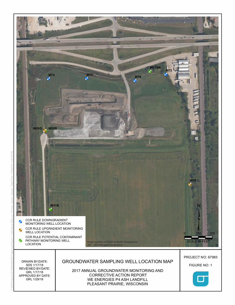
(1) A map, aerial image, or diagram showing the CCR unit and all background (or upgradient) and downgradient monitoring wells, to include the well identification numbers, that are part of the groundwater monitoring program for the CCR unit;
(2) Identification of any monitoring wells that were installed or decommissioned during the preceding year, along with a narrative description of why those actions were taken;
(3) In addition to all the monitoring data obtained under 40 CFR 257.90 through 257.98, a summary including the number of groundwater samples that were collected for analysis for each background and downgradient well, the dates the samples were collected, and whether the sample was required by the detection monitoring or assessment monitoring programs;
(4) A narrative discussion of any transition between monitoring programs (e.g., the date and circumstances for transitioning from detection monitoring to assessment monitoring in addition to identifying the constituent(s) detected at a statistically significant increase over background levels); and
(5) Other information required to be included in the annual report as specified in 40 CFR 257.90 through 257.98.1
This report provides the required information for the P4 Ash Landfill for calendar year 2017.
1.2 MONITORING AND CORRECTIVE ACTION PROGRAM STATUS
The final three independent samples of the minimum eight required by 40 CFR 257.94(b) were collected and analyzed from each background and downgradient well before October 17, 2017. The other five independent samples were collected and analyzed in 2015 and 2016.
The collection of eight independent background samples was completed by October 17, 2017. The first semi-annual monitoring sample for the Detection Monitoring Program for Appendix III parameters was collected on October 23-24, 2017 from each well; the analytical data was received on November 15, 2017. Determination of statistically significant increases (SSI) of Appendix III parameters over background concentrations will be completed within 90 days of completing the sample analysis, but not later than January 15, 2018.
1 For calendar year 2017, corrective action and other information required to be included in the annual report as specified in 40CFR 257.90 through 257.98 is not applicable.
O B G | J A N U A R Y 3 1 , 2 0 1 8
F I N A L | 2 O F 4
P4 Ash Landfill 2017 Annual Report FINAL 180129.docx
PLEASANT PRAIRIE POWER PLANT ASH LANDFILL 2017 ANNUAL GROUNDWATER MONITORING AND CORRECTIVE ACTION REPORT
KEY ACTIONS COMPLETED IN 2017
2 KEY ACTIONS COMPLETED IN 2017
2.1 SUMMARY
Three groundwater sampling events were completed in 2017 as part of an effort initiated in 2015 to collect eight independent samples from background and downgradient monitoring wells in accordance with 40 CFR 257.94(b).
Subsequent to collection of the eight independent samples, an additional sampling event was completed in October 2017 for parameters listed in Appendix III, 40 CFR Part 257, to supplement the background data set and as the first semi-annual monitoring sampling event for the Detection Monitoring Program.
A map showing the groundwater monitoring system, including the CCR unit and all background (upgradient) and downgradient monitoring wells with well identification numbers, for the P4 Ash Landfill is presented in Figure 1. No monitoring wells were installed or decommissioned from the monitoring system in 2017.
Samples were collected and analyzed in accordance with the Sampling and Analysis Plan (Natural Resource Technology, Inc., 2015) prepared for the P4 Ash Landfill.
All monitoring data obtained under 40 CFR 257.90 through 257.98 (as applicable) in 2017, as well as monitoring data for the previously collected five independent samples are presented in Tables 1 and 2. Sample collection dates in 2017 were January 11, April 11, August 31, and October 23. Sample collection dates for previously collected five independent samples are identified in Tables 1 and 2. One ground water sample was collected from each background and downgradient well in each sampling event.
Statistical evaluation of analytical data from the eight independent samples required to be collected by October 17, 2017 and the first semi-annual detection monitoring event on October 23-24, 2017 was initiated and will be completed within 90 days of October 17, 2017 (January 15, 2018). Statistical evaluation of analytical data is being performed in accordance with the Statistical Analysis Plan, P4 Ash Landfill (Natural Resource Technology, an OBG Company, 2017).
2.2 PROBLEMS ENCOUNTERED AND ACTIONS TO RESOLVE PROBLEMS
No problems were encountered with the groundwater monitoring program during 2017. Groundwater samples were collected and analyzed in accordance with the Sampling and Analysis Plan, and all data was accepted.
O B G | J A N U A R Y 3 1 , 2 0 1 8
F I N A L | 3 O F 4
P4 Ash Landfill 2017 Annual Report FINAL 180129.docx
PLEASANT PRAIRIE POWER PLANT ASH LANDFILL 2017 ANNUAL GROUNDWATER MONITORING AND CORRECTIVE ACTION REPORT
KEY ACTIVITIES PLANNED FOR 2018
3 KEY ACTIVITIES PLANNED FOR 2018
3.1 SUMMARY
The following key activities are planned for 2018:
Continuation of the Detection Monitoring Program with semi-annual sampling scheduled for the 2nd and 4th
quarters of 2018.
Complete evaluation of analytical data from the downgradient wells, using both the eight samples required to be collected by October 17, 2017 and the first semi-annual detection monitoring sample taken in October 2017 to determine whether a SSI of Appendix III parameters over background concentrations has occurred.
If an SSI is identified, potential alternate sources (i.e., a source other than the CCR unit caused the SSI or that that SSI resulted from error in sampling, analysis, statistical evaluation, or natural variation in groundwater quality) will be evaluated. If an alternate source is demonstrated to be the cause of the SSI, a written demonstration will be completed within 90 days of SSI detection and included in the annual groundwater monitoring and corrective action report for 2018.
» If an alternate source(s) is not identified to be the cause of the SSI, the applicable requirements of 40 CFR 257.94 through 257.98 (e.g., assessment monitoring) will apply in 2018, including associated recordkeeping/notifications required by 40 CFR 257.105 through 257.108.
O B G | J A N U A R Y 3 1 , 2 0 1 8
F I N A L | 4 O F 4
P4 Ash Landfill 2017 Annual Report FINAL 180129.docx
PLEASANT PRAIRIE POWER PLANT ASH LANDFILL 2017 ANNUAL GROUNDWATER MONITORING AND CORRECTIVE ACTION REPORT
REFERENCES
REFERENCES
Natural Resource Technology, Inc., 2015, Sampling and Analysis Plan Revision 1, Pleasant Prairie Power Plant Ash Landfill, Pleasant Prairie, Wisconsin, December 8, 2015.
Natural Resource Technology, an OBG Company, 2017, Statistical Analysis Plan, Pleasant Prairie Power Plant Ash Landfill, Pleasant Prairie, Wisconsin, October 17, 2017.

O B G T H E R E ’ S A W A Y
PLEASANT PRAIRIE POWER PLANT ASH LANDFILL 2017 ANNUAL GROUNDWATER MONITORING AND CORRECTIVE ACTION REPORT
Tables
January 23, 2018
11:41:30 AM
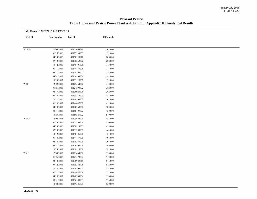
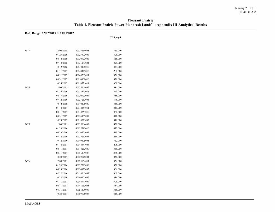
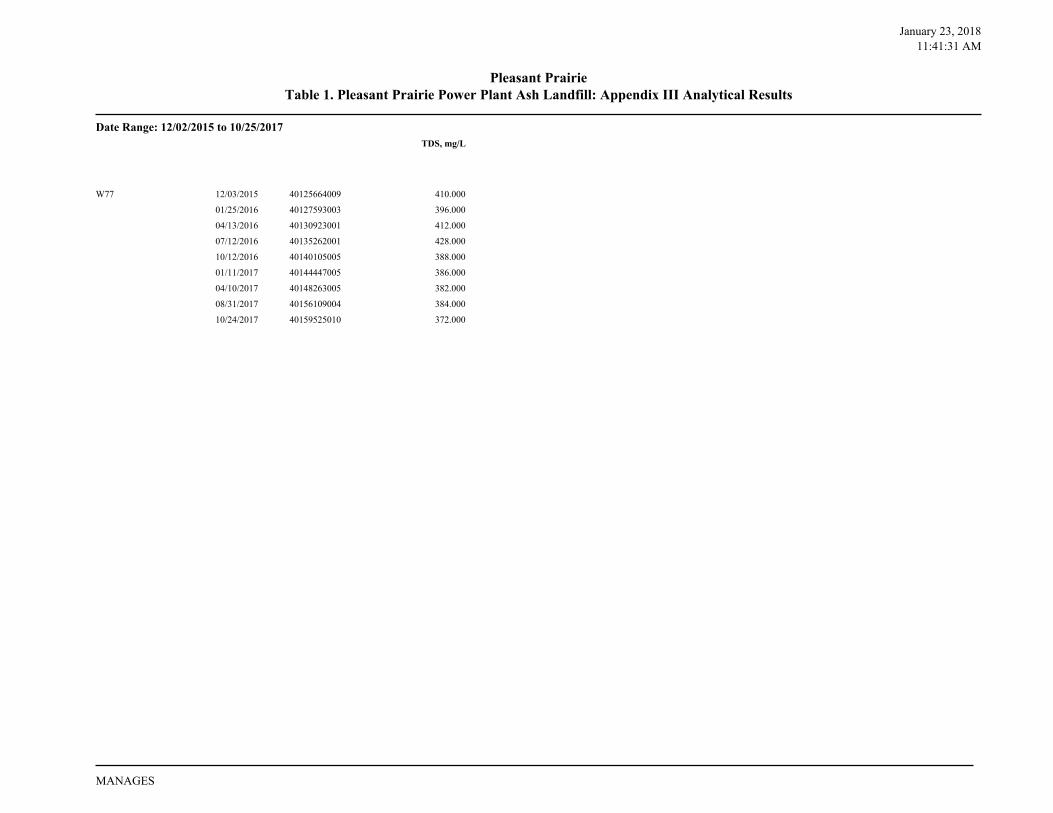
Date Range: 12/02/2015 to 10/25/2017
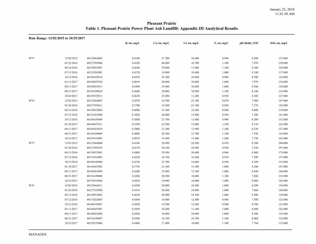
Table 1. Pleasant Prairie Power Plant Ash Landfill: Appendix III Analytical ResultsPleasant Prairie
B, tot, mg/L Ca, tot, mg/L Cl, tot, mg/L F, tot, mg/L pH (field), STD SO4, tot, mg/L
W17BR 12/03/2015 40125664010 0.5900 13.500 11.400 1.400 8.200 30.700
01/25/2016 40127593005 0.5850 13.600 11.400 1.400 8.040 28.100
04/14/2016 40130923011 0.6680 15.200 11.100 1.400 7.900 28.100
07/12/2016 40135262002 0.6260 13.900 11.600 1.300 7.900 28.900
10/12/2016 40140105006 0.6210 13.200 11.100 1.400 8.600 26.500
01/11/2017 40144447006 0.5560 12.000 10.800 1.400 8.420 25.300
04/11/2017 40148263007 0.6300 12.000 10.700 1.500 8.540 25.300
08/31/2017 40156109006 0.6500 12.700 11.000 1.500 8.020 25.100
10/23/2017 40159525007 0.6530 12.000 11.500 1.500 8.290 25.000
W20B 12/02/2015 40125664002 0.2860 54.800 14.300 0.770 7.600 95.700
01/25/2016 40127593002 0.2870 47.500 13.800 0.840 7.450 93.400
04/13/2016 40130923006 0.3200 57.800 10.400 0.840 10.000 74.500
07/13/2016 40135283003 0.3010 60.800 17.200 0.720 7.100 108.000
10/12/2016 40140105002 0.3070 91.300 23.400 0.740 7.500 125.000
01/10/2017 40144447002 0.2720 58.900 16.900 0.900 7.570 108.000
04/10/2017 40148263002 0.3000 52.400 13.500 0.800 7.680 93.100
08/31/2017 40156109002 0.3100 63.600 18.400 0.830 6.990 57.000
10/23/2017 40159525002 0.3390 85.700 28.700 0.770 7.200 161.000
W20D 12/02/2015 40125664001 0.4040 36.200 20.700 0.880 7.800 198.000
01/25/2016 40127593001 0.3910 32.700 18.700 0.990 7.660 195.000
04/13/2016 40130923005 0.4500 36.800 16.600 0.990 9.600 188.000
07/13/2016 40135283002 0.4190 33.400 17.100 0.940 7.400 188.000
10/12/2016 40140105001 0.4250 34.000 14.200 1.000 7.900 174.000
01/10/2017 40144447001 0.3880 29.000 14.700 1.100 7.800 175.000
04/10/2017 40148263001 0.4200 29.400 12.700 1.000 7.750 183.000
08/31/2017 40156109001 0.4400 27.900 11.300 1.100 7.400 72.200
10/23/2017 40159525001 0.4470 26.500 11.800 1.100 7.650 184.000
W31B 12/03/2015 40125664006 0.0872 86.700 33.700 0.370 7.500 118.000
01/26/2016 40127593007 0.0796 84.700 34.000 0.380 7.420 121.000
04/14/2016 40130923010 0.0933 94.300 32.300 0.380 7.400 113.000
07/12/2016 40135262006 0.0844 84.900 33.200 0.350 7.200 115.000
10/12/2016 40140105004 0.0924 98.400 40.800 0.330 7.600 119.000
01/11/2017 40144447009 0.0798 88.400 42.000 0.280 7.540 131.000
04/10/2017 40148263004 0.0960 86.200 35.400 0.300 7.590 123.000
08/31/2017 40156109003 0.0990 91.300 40.500 0.400 6.970 61.600
10/24/2017 40159525009 0.0932 91.200 38.900 <0.500 7.070 127.000
Well Id Date Sampled Lab Id
MANAGES
January 23, 2018
11:41:30 AM
Date Range: 12/02/2015 to 10/25/2017
Table 1. Pleasant Prairie Power Plant Ash Landfill: Appendix III Analytical ResultsPleasant Prairie
B, tot, mg/L Ca, tot, mg/L Cl, tot, mg/L F, tot, mg/L pH (field), STD SO4, tot, mg/L
W73 12/02/2015 40125664005 0.4180 27.300 10.400 0.990 8.200 123.000
01/25/2016 40127593006 0.4220 46.000 10.700 1.100 7.970 128.000
04/14/2016 40130923007 0.4640 29.800 11.000 1.100 8.300 120.000
07/13/2016 40135283001 0.4370 18.800 10.400 1.000 8.100 117.000
10/12/2016 40140105010 0.4470 35.300 10.900 0.990 8.500 124.000
01/11/2017 40144447010 0.4010 20.000 10.600 1.000 7.970 134.000
04/11/2017 40148263011 0.4300 25.600 10.400 1.000 8.500 128.000
08/31/2017 40156109010 0.4600 26.000 10.900 1.100 8.190 116.000
10/24/2017 40159525011 0.4630 25.800 11.200 0.950 8.360 127.000
W74 12/03/2015 40125664007 0.3670 34.700 22.100 0.870 7.900 147.000
01/26/2016 40127593011 0.3700 33.600 21.100 0.950 7.270 145.000
04/13/2016 40130923004 0.4080 31.500 18.300 0.960 8.800 139.000
07/12/2016 40135262008 0.3820 26.000 15.900 0.950 7.200 141.000
10/12/2016 40140105009 0.3890 23.700 13.400 0.990 8.200 152.000
01/10/2017 40144447011 0.3590 22.500 13.000 1.100 8.110 163.000
04/11/2017 40148263010 0.3800 21.200 13.900 1.100 8.220 157.000
08/31/2017 40156109009 0.4000 20.300 12.700 1.100 7.550 136.000
10/23/2017 40159525003 0.4070 19.500 13.800 1.200 7.750 162.000
W75 12/03/2015 40125664008 0.4100 28.900 24.300 0.910 8.200 208.000
01/26/2016 40127593010 0.4170 30.100 24.500 0.950 7.550 197.000
04/13/2016 40130923003 0.4480 29.500 20.600 0.960 8.800 179.000
07/12/2016 40135262005 0.4220 24.700 16.200 0.910 7.500 157.000
10/12/2016 40140105008 0.4250 23.700 14.000 0.950 8.500 155.000
01/10/2017 40144447003 0.3750 21.300 13.500 1.000 8.240 147.000
04/11/2017 40148263009 0.4200 22.600 12.100 1.000 8.440 148.000
08/31/2017 40156109008 0.4300 20.500 10.600 1.100 7.860 132.000
10/23/2017 40159525004 0.4430 19.900 10.800 1.000 8.060 145.000
W76 12/03/2015 40125664011 0.4240 20.000 18.300 1.000 8.200 138.000
01/26/2016 40127593008 0.4310 20.600 16.400 1.000 7.660 140.000
04/13/2016 40130923002 0.4630 20.900 14.100 1.000 9.500 130.000
07/12/2016 40135262003 0.4360 18.800 12.400 0.980 7.500 125.000
10/12/2016 40140105007 0.4430 19.500 12.600 0.940 8.700 135.000
01/11/2017 40144447007 0.3950 18.200 11.200 1.000 8.400 142.000
04/11/2017 40148263008 0.4200 18.000 10.900 1.000 8.580 135.000
08/31/2017 40156109007 0.4500 18.100 10.700 1.100 8.060 122.000
10/23/2017 40159525006 0.4460 17.600 10.800 1.100 7.760 135.000
MANAGES

January 23, 2018
11:41:30 AM
Date Range: 12/02/2015 to 10/25/2017
Table 1. Pleasant Prairie Power Plant Ash Landfill: Appendix III Analytical ResultsPleasant Prairie
B, tot, mg/L Ca, tot, mg/L Cl, tot, mg/L F, tot, mg/L pH (field), STD SO4, tot, mg/L
W77 12/03/2015 40125664009 0.3730 33.800 19.600 0.850 7.600 157.000
01/25/2016 40127593003 0.3780 34.800 18.900 0.870 7.290 156.000
04/13/2016 40130923001 0.4000 34.000 16.900 0.920 8.400 149.000
07/12/2016 40135262001 0.4160 31.100 14.800 0.910 7.300 139.000
10/12/2016 40140105005 0.4150 30.700 13.800 0.970 7.900 142.000
01/11/2017 40144447005 0.3650 27.700 13.200 1.000 7.630 143.000
04/10/2017 40148263005 0.4100 27.300 12.000 1.000 7.700 143.000
08/31/2017 40156109004 0.4300 26.000 11.200 1.100 7.190 67.700
10/24/2017 40159525010 0.4320 25.500 11.000 1.100 7.710 142.000
MANAGES
January 23, 2018
11:41:31 AM
Date Range: 12/02/2015 to 10/25/2017
Table 1. Pleasant Prairie Power Plant Ash Landfill: Appendix III Analytical ResultsPleasant Prairie
TDS, mg/L
W17BR 12/03/2015 40125664010 168.000
01/25/2016 40127593005 172.000
04/14/2016 40130923011 208.000
07/12/2016 40135262002 202.000
10/12/2016 40140105006 178.000
01/11/2017 40144447006 178.000
04/11/2017 40148263007 184.000
08/31/2017 40156109006 182.000
10/23/2017 40159525007 172.000
W20B 12/02/2015 40125664002 410.000
01/25/2016 40127593002 362.000
04/13/2016 40130923006 362.000
07/13/2016 40135283003 458.000
10/12/2016 40140105002 502.000
01/10/2017 40144447002 412.000
04/10/2017 40148263002 382.000
08/31/2017 40156109002 450.000
10/23/2017 40159525002 510.000
W20D 12/02/2015 40125664001 452.000
01/25/2016 40127593001 410.000
04/13/2016 40130923005 428.000
07/13/2016 40135283002 464.000
10/12/2016 40140105001 424.000
01/10/2017 40144447001 406.000
04/10/2017 40148263001 398.000
08/31/2017 40156109001 396.000
10/23/2017 40159525001 382.000
W31B 12/03/2015 40125664006 530.000
01/26/2016 40127593007 512.000
04/14/2016 40130923010 546.000
07/12/2016 40135262006 572.000
10/12/2016 40140105004 528.000
01/11/2017 40144447009 522.000
04/10/2017 40148263004 530.000
08/31/2017 40156109003 536.000
10/24/2017 40159525009 530.000
Well Id Date Sampled Lab Id
MANAGES
January 23, 2018
11:41:31 AM
Date Range: 12/02/2015 to 10/25/2017
Table 1. Pleasant Prairie Power Plant Ash Landfill: Appendix III Analytical ResultsPleasant Prairie
TDS, mg/L
W73 12/02/2015 40125664005 310.000
01/25/2016 40127593006 306.000
04/14/2016 40130923007 318.000
07/13/2016 40135283001 328.000
10/12/2016 40140105010 324.000
01/11/2017 40144447010 280.000
04/11/2017 40148263011 336.000
08/31/2017 40156109010 328.000
10/24/2017 40159525011 308.000
W74 12/03/2015 40125664007 384.000
01/26/2016 40127593011 360.000
04/13/2016 40130923004 388.000
07/12/2016 40135262008 376.000
10/12/2016 40140105009 346.000
01/10/2017 40144447011 340.000
04/11/2017 40148263010 360.000
08/31/2017 40156109009 372.000
10/23/2017 40159525003 348.000
W75 12/03/2015 40125664008 438.000
01/26/2016 40127593010 432.000
04/13/2016 40130923003 430.000
07/12/2016 40135262005 416.000
10/12/2016 40140105008 362.000
01/10/2017 40144447003 298.000
04/11/2017 40148263009 358.000
08/31/2017 40156109008 356.000
10/23/2017 40159525004 330.000
W76 12/03/2015 40125664011 334.000
01/26/2016 40127593008 330.000
04/13/2016 40130923002 366.000
07/12/2016 40135262003 360.000
10/12/2016 40140105007 336.000
01/11/2017 40144447007 306.000
04/11/2017 40148263008 334.000
08/31/2017 40156109007 336.000
10/23/2017 40159525006 318.000
MANAGES
January 23, 2018
11:41:31 AM
Date Range: 12/02/2015 to 10/25/2017
Table 1. Pleasant Prairie Power Plant Ash Landfill: Appendix III Analytical ResultsPleasant Prairie
TDS, mg/L
W77 12/03/2015 40125664009 410.000
01/25/2016 40127593003 396.000
04/13/2016 40130923001 412.000
07/12/2016 40135262001 428.000
10/12/2016 40140105005 388.000
01/11/2017 40144447005 386.000
04/10/2017 40148263005 382.000
08/31/2017 40156109004 384.000
10/24/2017 40159525010 372.000
MANAGES
January 23, 2018
11:42:01 AM
Date Range: 12/02/2015 to 10/17/2017
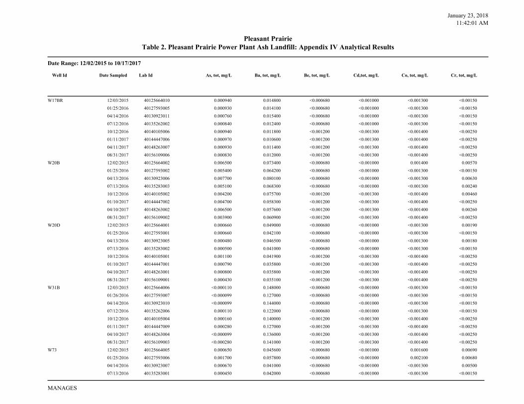
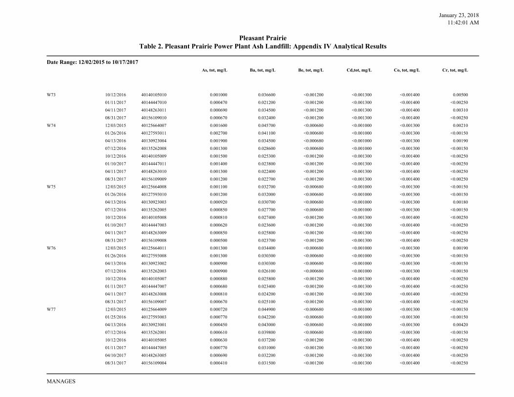
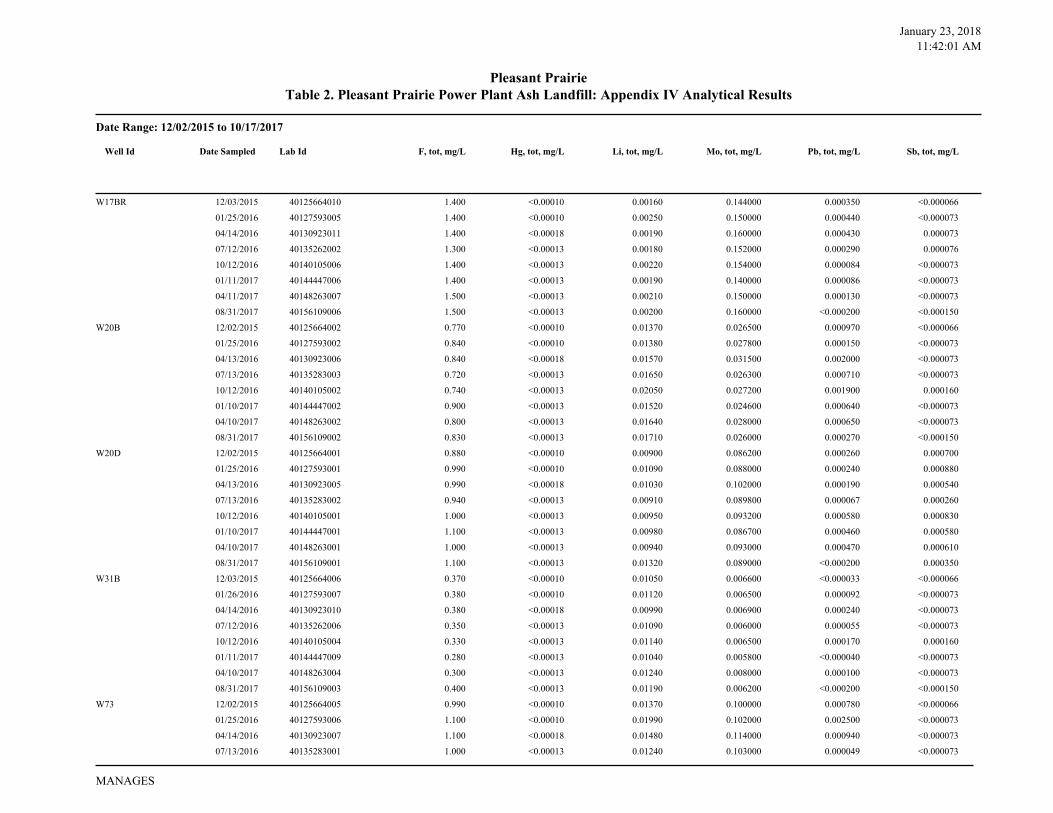
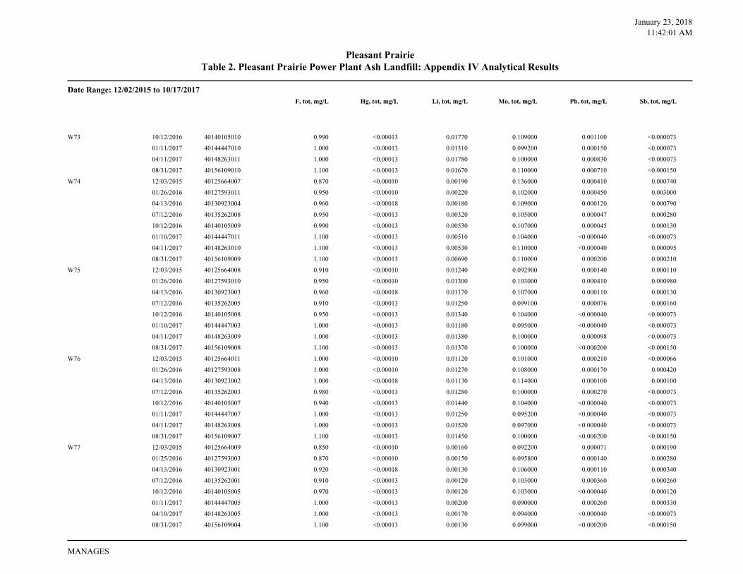
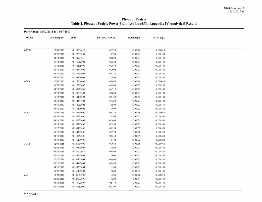
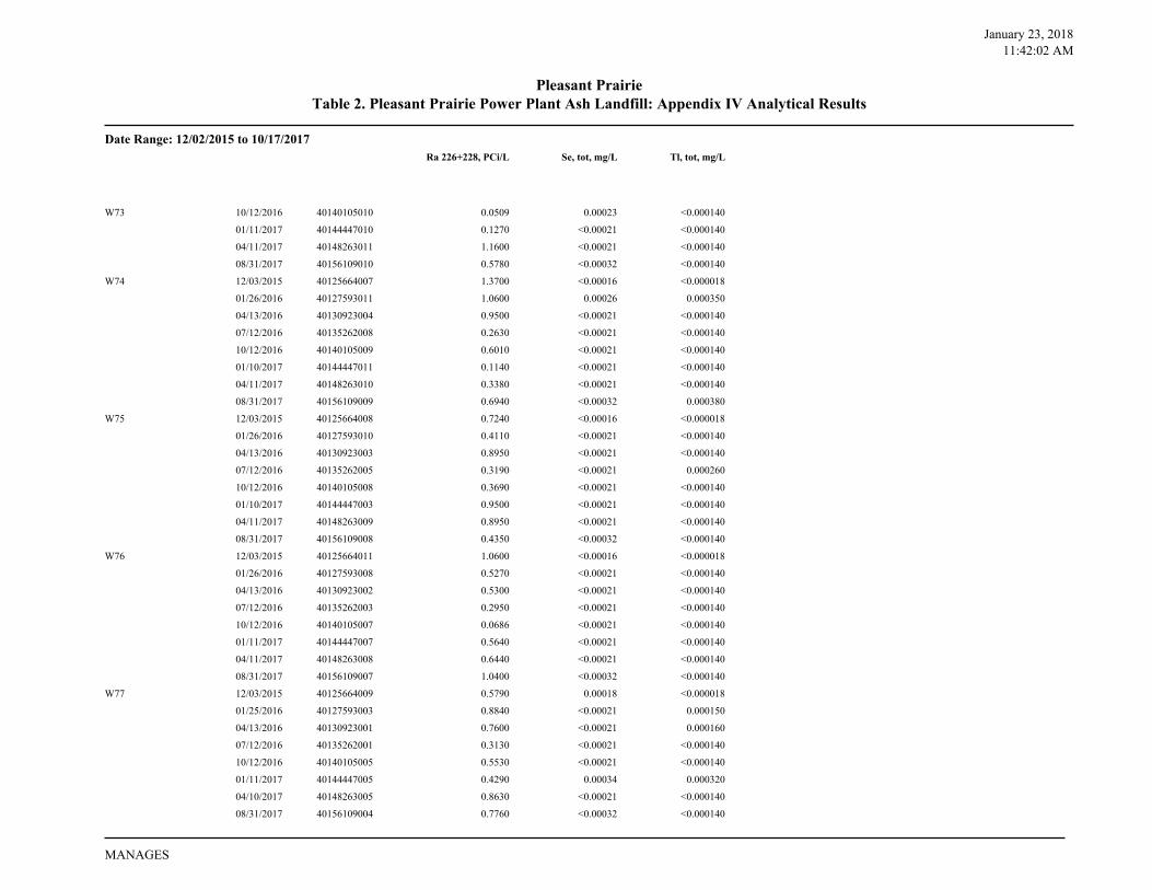
Table 2. Pleasant Prairie Power Plant Ash Landfill: Appendix IV Analytical ResultsPleasant Prairie
As, tot, mg/L Ba, tot, mg/L Be, tot, mg/L Cd,tot, mg/L Co, tot, mg/L Cr, tot, mg/L
W17BR 12/03/2015 40125664010 0.000940 0.014800 <0.000680 <0.001000 <0.001300 <0.00150
01/25/2016 40127593005 0.000930 0.014100 <0.000680 <0.001000 <0.001300 <0.00150
04/14/2016 40130923011 0.000760 0.015400 <0.000680 <0.001000 <0.001300 <0.00150
07/12/2016 40135262002 0.000840 0.012400 <0.000680 <0.001000 <0.001300 <0.00150
10/12/2016 40140105006 0.000940 0.011800 <0.001200 <0.001300 <0.001400 <0.00250
01/11/2017 40144447006 0.000970 0.010600 <0.001200 <0.001300 <0.001400 <0.00250
04/11/2017 40148263007 0.000930 0.011400 <0.001200 <0.001300 <0.001400 <0.00250
08/31/2017 40156109006 0.000830 0.012000 <0.001200 <0.001300 <0.001400 <0.00250
W20B 12/02/2015 40125664002 0.006500 0.073400 <0.000680 <0.001000 0.001400 0.00570
01/25/2016 40127593002 0.005400 0.064200 <0.000680 <0.001000 <0.001300 <0.00150
04/13/2016 40130923006 0.007700 0.080100 <0.000680 <0.001000 <0.001300 0.00630
07/13/2016 40135283003 0.005100 0.068300 <0.000680 <0.001000 <0.001300 0.00240
10/12/2016 40140105002 0.004200 0.075700 <0.001200 <0.001300 <0.001400 0.00460
01/10/2017 40144447002 0.004700 0.058300 <0.001200 <0.001300 <0.001400 <0.00250
04/10/2017 40148263002 0.006500 0.057600 <0.001200 <0.001300 <0.001400 0.00260
08/31/2017 40156109002 0.003900 0.060900 <0.001200 <0.001300 <0.001400 <0.00250
W20D 12/02/2015 40125664001 0.000660 0.049000 <0.000680 <0.001000 <0.001300 0.00190
01/25/2016 40127593001 0.000660 0.042100 <0.000680 <0.001000 <0.001300 <0.00150
04/13/2016 40130923005 0.000480 0.046500 <0.000680 <0.001000 <0.001300 0.00180
07/13/2016 40135283002 0.000500 0.041000 <0.000680 <0.001000 <0.001300 <0.00150
10/12/2016 40140105001 0.001100 0.041900 <0.001200 <0.001300 <0.001400 <0.00250
01/10/2017 40144447001 0.000790 0.035800 <0.001200 <0.001300 <0.001400 <0.00250
04/10/2017 40148263001 0.000800 0.035800 <0.001200 <0.001300 <0.001400 <0.00250
08/31/2017 40156109001 0.000430 0.035100 <0.001200 <0.001300 <0.001400 <0.00250
W31B 12/03/2015 40125664006 <0.000110 0.148000 <0.000680 <0.001000 <0.001300 <0.00150
01/26/2016 40127593007 <0.000099 0.127000 <0.000680 <0.001000 <0.001300 <0.00150
04/14/2016 40130923010 <0.000099 0.144000 <0.000680 <0.001000 <0.001300 <0.00150
07/12/2016 40135262006 0.000110 0.122000 <0.000680 <0.001000 <0.001300 <0.00150
10/12/2016 40140105004 0.000160 0.140000 <0.001200 <0.001300 <0.001400 <0.00250
01/11/2017 40144447009 0.000280 0.127000 <0.001200 <0.001300 <0.001400 <0.00250
04/10/2017 40148263004 <0.000099 0.136000 <0.001200 <0.001300 <0.001400 <0.00250
08/31/2017 40156109003 <0.000280 0.141000 <0.001200 <0.001300 <0.001400 <0.00250
W73 12/02/2015 40125664005 0.000650 0.045600 <0.000680 <0.001000 0.001600 0.00690
01/25/2016 40127593006 0.001700 0.057800 <0.000680 <0.001000 0.002100 0.00680
04/14/2016 40130923007 0.000670 0.041000 <0.000680 <0.001000 <0.001300 0.00500
07/13/2016 40135283001 0.000450 0.042000 <0.000680 <0.001000 <0.001300 <0.00150
Well Id Date Sampled Lab Id
MANAGES
January 23, 2018
11:42:01 AM
Date Range: 12/02/2015 to 10/17/2017
Table 2. Pleasant Prairie Power Plant Ash Landfill: Appendix IV Analytical ResultsPleasant Prairie
As, tot, mg/L Ba, tot, mg/L Be, tot, mg/L Cd,tot, mg/L Co, tot, mg/L Cr, tot, mg/L
W73 10/12/2016 40140105010 0.001000 0.036600 <0.001200 <0.001300 <0.001400 0.00500
01/11/2017 40144447010 0.000470 0.021200 <0.001200 <0.001300 <0.001400 <0.00250
04/11/2017 40148263011 0.000690 0.034500 <0.001200 <0.001300 <0.001400 0.00310
08/31/2017 40156109010 0.000670 0.032400 <0.001200 <0.001300 <0.001400 <0.00250
W74 12/03/2015 40125664007 0.001600 0.045700 <0.000680 <0.001000 <0.001300 0.00210
01/26/2016 40127593011 0.002700 0.041100 <0.000680 <0.001000 <0.001300 <0.00150
04/13/2016 40130923004 0.001900 0.034500 <0.000680 <0.001000 <0.001300 0.00190
07/12/2016 40135262008 0.001300 0.028600 <0.000680 <0.001000 <0.001300 <0.00150
10/12/2016 40140105009 0.001500 0.025300 <0.001200 <0.001300 <0.001400 <0.00250
01/10/2017 40144447011 0.001400 0.023800 <0.001200 <0.001300 <0.001400 <0.00250
04/11/2017 40148263010 0.001300 0.022400 <0.001200 <0.001300 <0.001400 <0.00250
08/31/2017 40156109009 0.001200 0.022700 <0.001200 <0.001300 <0.001400 <0.00250
W75 12/03/2015 40125664008 0.001100 0.032700 <0.000680 <0.001000 <0.001300 <0.00150
01/26/2016 40127593010 0.001200 0.032000 <0.000680 <0.001000 <0.001300 <0.00150
04/13/2016 40130923003 0.000920 0.030700 <0.000680 <0.001000 <0.001300 0.00180
07/12/2016 40135262005 0.000850 0.027700 <0.000680 <0.001000 <0.001300 <0.00150
10/12/2016 40140105008 0.000810 0.027400 <0.001200 <0.001300 <0.001400 <0.00250
01/10/2017 40144447003 0.000620 0.023600 <0.001200 <0.001300 <0.001400 <0.00250
04/11/2017 40148263009 0.000850 0.025800 <0.001200 <0.001300 <0.001400 <0.00250
08/31/2017 40156109008 0.000500 0.023700 <0.001200 <0.001300 <0.001400 <0.00250
W76 12/03/2015 40125664011 0.001300 0.034400 <0.000680 <0.001000 <0.001300 0.00190
01/26/2016 40127593008 0.001300 0.030300 <0.000680 <0.001000 <0.001300 <0.00150
04/13/2016 40130923002 0.000900 0.030300 <0.000680 <0.001000 <0.001300 <0.00150
07/12/2016 40135262003 0.000900 0.026100 <0.000680 <0.001000 <0.001300 <0.00150
10/12/2016 40140105007 0.000880 0.025800 <0.001200 <0.001300 <0.001400 <0.00250
01/11/2017 40144447007 0.000680 0.023400 <0.001200 <0.001300 <0.001400 <0.00250
04/11/2017 40148263008 0.000810 0.024200 <0.001200 <0.001300 <0.001400 <0.00250
08/31/2017 40156109007 0.000670 0.025100 <0.001200 <0.001300 <0.001400 <0.00250
W77 12/03/2015 40125664009 0.000720 0.044900 <0.000680 <0.001000 <0.001300 <0.00150
01/25/2016 40127593003 0.000770 0.042200 <0.000680 <0.001000 <0.001300 <0.00150
04/13/2016 40130923001 0.000450 0.043000 <0.000680 <0.001000 <0.001300 0.00420
07/12/2016 40135262001 0.000610 0.039800 <0.000680 <0.001000 <0.001300 <0.00150
10/12/2016 40140105005 0.000630 0.037200 <0.001200 <0.001300 <0.001400 <0.00250
01/11/2017 40144447005 0.000770 0.031000 <0.001200 <0.001300 <0.001400 <0.00250
04/10/2017 40148263005 0.000690 0.032200 <0.001200 <0.001300 <0.001400 <0.00250
08/31/2017 40156109004 0.000410 0.031500 <0.001200 <0.001300 <0.001400 <0.00250
MANAGES
January 23, 2018
11:42:01 AM
Date Range: 12/02/2015 to 10/17/2017
Table 2. Pleasant Prairie Power Plant Ash Landfill: Appendix IV Analytical ResultsPleasant Prairie
F, tot, mg/L Hg, tot, mg/L Li, tot, mg/L Mo, tot, mg/L Pb, tot, mg/L Sb, tot, mg/L
W17BR 12/03/2015 40125664010 1.400 <0.00010 0.00160 0.144000 0.000350 <0.000066
01/25/2016 40127593005 1.400 <0.00010 0.00250 0.150000 0.000440 <0.000073
04/14/2016 40130923011 1.400 <0.00018 0.00190 0.160000 0.000430 0.000073
07/12/2016 40135262002 1.300 <0.00013 0.00180 0.152000 0.000290 0.000076
10/12/2016 40140105006 1.400 <0.00013 0.00220 0.154000 0.000084 <0.000073
01/11/2017 40144447006 1.400 <0.00013 0.00190 0.140000 0.000086 <0.000073
04/11/2017 40148263007 1.500 <0.00013 0.00210 0.150000 0.000130 <0.000073
08/31/2017 40156109006 1.500 <0.00013 0.00200 0.160000 <0.000200 <0.000150
W20B 12/02/2015 40125664002 0.770 <0.00010 0.01370 0.026500 0.000970 <0.000066
01/25/2016 40127593002 0.840 <0.00010 0.01380 0.027800 0.000150 <0.000073
04/13/2016 40130923006 0.840 <0.00018 0.01570 0.031500 0.002000 <0.000073
07/13/2016 40135283003 0.720 <0.00013 0.01650 0.026300 0.000710 <0.000073
10/12/2016 40140105002 0.740 <0.00013 0.02050 0.027200 0.001900 0.000160
01/10/2017 40144447002 0.900 <0.00013 0.01520 0.024600 0.000640 <0.000073
04/10/2017 40148263002 0.800 <0.00013 0.01640 0.028000 0.000650 <0.000073
08/31/2017 40156109002 0.830 <0.00013 0.01710 0.026000 0.000270 <0.000150
W20D 12/02/2015 40125664001 0.880 <0.00010 0.00900 0.086200 0.000260 0.000700
01/25/2016 40127593001 0.990 <0.00010 0.01090 0.088000 0.000240 0.000880
04/13/2016 40130923005 0.990 <0.00018 0.01030 0.102000 0.000190 0.000540
07/13/2016 40135283002 0.940 <0.00013 0.00910 0.089800 0.000067 0.000260
10/12/2016 40140105001 1.000 <0.00013 0.00950 0.093200 0.000580 0.000830
01/10/2017 40144447001 1.100 <0.00013 0.00980 0.086700 0.000460 0.000580
04/10/2017 40148263001 1.000 <0.00013 0.00940 0.093000 0.000470 0.000610
08/31/2017 40156109001 1.100 <0.00013 0.01320 0.089000 <0.000200 0.000350
W31B 12/03/2015 40125664006 0.370 <0.00010 0.01050 0.006600 <0.000033 <0.000066
01/26/2016 40127593007 0.380 <0.00010 0.01120 0.006500 0.000092 <0.000073
04/14/2016 40130923010 0.380 <0.00018 0.00990 0.006900 0.000240 <0.000073
07/12/2016 40135262006 0.350 <0.00013 0.01090 0.006000 0.000055 <0.000073
10/12/2016 40140105004 0.330 <0.00013 0.01140 0.006500 0.000170 0.000160
01/11/2017 40144447009 0.280 <0.00013 0.01040 0.005800 <0.000040 <0.000073
04/10/2017 40148263004 0.300 <0.00013 0.01240 0.008000 0.000100 <0.000073
08/31/2017 40156109003 0.400 <0.00013 0.01190 0.006200 <0.000200 <0.000150
W73 12/02/2015 40125664005 0.990 <0.00010 0.01370 0.100000 0.000780 <0.000066
01/25/2016 40127593006 1.100 <0.00010 0.01990 0.102000 0.002500 <0.000073
04/14/2016 40130923007 1.100 <0.00018 0.01480 0.114000 0.000940 <0.000073
07/13/2016 40135283001 1.000 <0.00013 0.01240 0.103000 0.000049 <0.000073
Well Id Date Sampled Lab Id
MANAGES
January 23, 2018
11:42:01 AM
Date Range: 12/02/2015 to 10/17/2017
Table 2. Pleasant Prairie Power Plant Ash Landfill: Appendix IV Analytical ResultsPleasant Prairie
F, tot, mg/L Hg, tot, mg/L Li, tot, mg/L Mo, tot, mg/L Pb, tot, mg/L Sb, tot, mg/L
W73 10/12/2016 40140105010 0.990 <0.00013 0.01770 0.109000 0.001100 <0.000073
01/11/2017 40144447010 1.000 <0.00013 0.01310 0.099200 0.000150 <0.000073
04/11/2017 40148263011 1.000 <0.00013 0.01780 0.100000 0.000830 <0.000073
08/31/2017 40156109010 1.100 <0.00013 0.01670 0.110000 0.000710 <0.000150
W74 12/03/2015 40125664007 0.870 <0.00010 0.00190 0.136000 0.000410 0.000740
01/26/2016 40127593011 0.950 <0.00010 0.00220 0.102000 0.000450 0.003000
04/13/2016 40130923004 0.960 <0.00018 0.00180 0.109000 0.000120 0.000790
07/12/2016 40135262008 0.950 <0.00013 0.00320 0.105000 0.000047 0.000280
10/12/2016 40140105009 0.990 <0.00013 0.00530 0.107000 0.000045 0.000130
01/10/2017 40144447011 1.100 <0.00013 0.00510 0.104000 <0.000040 <0.000073
04/11/2017 40148263010 1.100 <0.00013 0.00530 0.110000 <0.000040 0.000095
08/31/2017 40156109009 1.100 <0.00013 0.00690 0.110000 0.000200 0.000210
W75 12/03/2015 40125664008 0.910 <0.00010 0.01240 0.092900 0.000140 0.000110
01/26/2016 40127593010 0.950 <0.00010 0.01300 0.103000 0.000410 0.000980
04/13/2016 40130923003 0.960 <0.00018 0.01170 0.107000 0.000110 0.000130
07/12/2016 40135262005 0.910 <0.00013 0.01250 0.099100 0.000076 0.000160
10/12/2016 40140105008 0.950 <0.00013 0.01340 0.104000 <0.000040 <0.000073
01/10/2017 40144447003 1.000 <0.00013 0.01180 0.095000 <0.000040 <0.000073
04/11/2017 40148263009 1.000 <0.00013 0.01380 0.100000 0.000098 <0.000073
08/31/2017 40156109008 1.100 <0.00013 0.01370 0.100000 <0.000200 <0.000150
W76 12/03/2015 40125664011 1.000 <0.00010 0.01120 0.101000 0.000210 <0.000066
01/26/2016 40127593008 1.000 <0.00010 0.01270 0.108000 0.000170 0.000420
04/13/2016 40130923002 1.000 <0.00018 0.01130 0.114000 0.000100 0.000100
07/12/2016 40135262003 0.980 <0.00013 0.01280 0.100000 0.000270 <0.000073
10/12/2016 40140105007 0.940 <0.00013 0.01440 0.104000 <0.000040 <0.000073
01/11/2017 40144447007 1.000 <0.00013 0.01250 0.095200 <0.000040 <0.000073
04/11/2017 40148263008 1.000 <0.00013 0.01520 0.097000 <0.000040 <0.000073
08/31/2017 40156109007 1.100 <0.00013 0.01450 0.100000 <0.000200 <0.000150
W77 12/03/2015 40125664009 0.850 <0.00010 0.00160 0.092200 0.000071 0.000190
01/25/2016 40127593003 0.870 <0.00010 0.00150 0.095800 0.000140 0.000280
04/13/2016 40130923001 0.920 <0.00018 0.00130 0.106000 0.000110 0.000340
07/12/2016 40135262001 0.910 <0.00013 0.00120 0.103000 0.000360 0.000260
10/12/2016 40140105005 0.970 <0.00013 0.00120 0.103000 <0.000040 0.000120
01/11/2017 40144447005 1.000 <0.00013 0.00200 0.090000 0.000260 0.000330
04/10/2017 40148263005 1.000 <0.00013 0.00170 0.094000 <0.000040 <0.000073
08/31/2017 40156109004 1.100 <0.00013 0.00130 0.099000 <0.000200 <0.000150
MANAGES
January 23, 2018
11:42:02 AM
Date Range: 12/02/2015 to 10/17/2017
Table 2. Pleasant Prairie Power Plant Ash Landfill: Appendix IV Analytical ResultsPleasant Prairie
Ra 226+228, PCi/L Se, tot, mg/L Tl, tot, mg/L
W17BR 12/03/2015 40125664010 0.3770 <0.00016 <0.000018
01/25/2016 40127593005 1.0900 <0.00021 <0.000140
04/14/2016 40130923011 0.0000 <0.00021 <0.000140
07/12/2016 40135262002 0.2240 <0.00021 <0.000140
10/12/2016 40140105006 0.3670 <0.00021 <0.000140
01/11/2017 40144447006 0.2990 <0.00021 <0.000140
04/11/2017 40148263007 0.0714 <0.00021 <0.000140
08/31/2017 40156109006 1.1400 <0.00032 <0.000140
W20B 12/02/2015 40125664002 0.0673 <0.00016 0.000029
01/25/2016 40127593002 0.8840 <0.00021 0.000150
04/13/2016 40130923006 0.4710 <0.00021 <0.000140
07/13/2016 40135283003 0.0000 <0.00021 <0.000140
10/12/2016 40140105002 0.6420 0.00052 0.000180
01/10/2017 40144447002 0.1280 <0.00021 <0.000140
04/10/2017 40148263002 1.0500 <0.00021 0.000170
08/31/2017 40156109002 1.4600 <0.00032 <0.000140
W20D 12/02/2015 40125664001 0.9710 <0.00016 <0.000018
01/25/2016 40127593001 1.4700 <0.00021 0.000200
04/13/2016 40130923005 0.3090 <0.00021 <0.000140
07/13/2016 40135283002 0.3990 <0.00021 <0.000140
10/12/2016 40140105001 0.8330 0.00057 0.000490
01/10/2017 40144447001 0.9790 0.00040 0.000550
04/10/2017 40148263001 0.6360 0.00049 0.000630
08/31/2017 40156109001 1.0100 <0.00032 0.000240
W31B 12/03/2015 40125664006 0.7050 <0.00016 <0.000018
01/26/2016 40127593007 1.4500 <0.00021 <0.000140
04/14/2016 40130923010 0.8400 <0.00021 <0.000140
07/12/2016 40135262006 1.1000 <0.00021 <0.000140
10/12/2016 40140105004 0.6940 <0.00021 0.000230
01/11/2017 40144447009 0.8490 <0.00021 <0.000140
04/10/2017 40148263004 1.5300 <0.00021 <0.000140
08/31/2017 40156109003 1.7800 <0.00032 <0.000140
W73 12/02/2015 40125664005 1.1200 <0.00016 <0.000018
01/25/2016 40127593006 1.4200 0.00047 <0.000140
04/14/2016 40130923007 0.5410 <0.00021 <0.000140
07/13/2016 40135283001 0.1300 <0.00021 <0.000140
Well Id Date Sampled Lab Id
MANAGES
January 23, 2018
11:42:02 AM
Date Range: 12/02/2015 to 10/17/2017
Table 2. Pleasant Prairie Power Plant Ash Landfill: Appendix IV Analytical ResultsPleasant Prairie
Ra 226+228, PCi/L Se, tot, mg/L Tl, tot, mg/L
W73 10/12/2016 40140105010 0.0509 0.00023 <0.000140
01/11/2017 40144447010 0.1270 <0.00021 <0.000140
04/11/2017 40148263011 1.1600 <0.00021 <0.000140
08/31/2017 40156109010 0.5780 <0.00032 <0.000140
W74 12/03/2015 40125664007 1.3700 <0.00016 <0.000018
01/26/2016 40127593011 1.0600 0.00026 0.000350
04/13/2016 40130923004 0.9500 <0.00021 <0.000140
07/12/2016 40135262008 0.2630 <0.00021 <0.000140
10/12/2016 40140105009 0.6010 <0.00021 <0.000140
01/10/2017 40144447011 0.1140 <0.00021 <0.000140
04/11/2017 40148263010 0.3380 <0.00021 <0.000140
08/31/2017 40156109009 0.6940 <0.00032 0.000380
W75 12/03/2015 40125664008 0.7240 <0.00016 <0.000018
01/26/2016 40127593010 0.4110 <0.00021 <0.000140
04/13/2016 40130923003 0.8950 <0.00021 <0.000140
07/12/2016 40135262005 0.3190 <0.00021 0.000260
10/12/2016 40140105008 0.3690 <0.00021 <0.000140
01/10/2017 40144447003 0.9500 <0.00021 <0.000140
04/11/2017 40148263009 0.8950 <0.00021 <0.000140
08/31/2017 40156109008 0.4350 <0.00032 <0.000140
W76 12/03/2015 40125664011 1.0600 <0.00016 <0.000018
01/26/2016 40127593008 0.5270 <0.00021 <0.000140
04/13/2016 40130923002 0.5300 <0.00021 <0.000140
07/12/2016 40135262003 0.2950 <0.00021 <0.000140
10/12/2016 40140105007 0.0686 <0.00021 <0.000140
01/11/2017 40144447007 0.5640 <0.00021 <0.000140
04/11/2017 40148263008 0.6440 <0.00021 <0.000140
08/31/2017 40156109007 1.0400 <0.00032 <0.000140
W77 12/03/2015 40125664009 0.5790 0.00018 <0.000018
01/25/2016 40127593003 0.8840 <0.00021 0.000150
04/13/2016 40130923001 0.7600 <0.00021 0.000160
07/12/2016 40135262001 0.3130 <0.00021 <0.000140
10/12/2016 40140105005 0.5530 <0.00021 <0.000140
01/11/2017 40144447005 0.4290 0.00034 0.000320
04/10/2017 40148263005 0.8630 <0.00021 <0.000140
08/31/2017 40156109004 0.7760 <0.00032 <0.000140
MANAGES
O B G T H E R E ’ S A W A Y
PLEASANT PRAIRIE POWER PLANT ASH LANDFILL 2017 ANNUAL GROUNDWATER MONITORING AND CORRECTIVE ACTION REPORT
Figures
"D
"D
"D
"D
"D"D "D "D
"D
W20B
W31B
W17BR
W20D
W77
W73W74 W75 W76
0 300150
SCALE IN FEET
PROJECT NO: 67985FIGURE NO: 1
"DCCR RULE DOWNGRADIENTMONITORING WELL LOCATION
"DCCR RULE UPGRADIENT MONITORINGWELL LOCATION
"D
CCR RULE POTENTIAL CONTAMINANTPATHWAY MONITORING WELLLOCATION
DRAWN BY/DATE:SDS 1/17/18
REVIEWED BY/DATE:GRL 1/17/18
APPROVED BY DATE:GRL 1/29/18
³GROUNDWATER SAMPLING WELL LOCATION MAP
2017 ANNUAL GROUNDWATER MONITORING AND CORRECTIVE ACTION REPORTWE ENERGIES P4 ASH LANDFILLPLEASANT PRAIRIE, WISCONSIN
Y:\G
IS\Pr
ojects
\16\16
60\M
XD\20
17ag
wmca
r\Figu
re 1_
GW Sa
mp W
ell Lo
c_P4
.mxd
Auth
or: st
olzsd
; Date
/Time
: 1/29
/2018
, 5:05
:20 PM
Image courtesy of USGS Earthstar GeographicsSIO 2015 Microsoft Corporation©

OBG
THERE’S A WAY