Embed Size (px)
Citation preview

Australian Journal of Earth Sciences
(2003)
50
,
403–426
Plio-Pleistocene tectonics and eustasy in the Gippsland Basin, southeast Australia: evidence from magnetic imagery and marine geological data
G. R. HOLDGATE,
1
* M. W. WALLACE,
1
S. J. GALLAGHER,
1
A. J. SMITH,
1
J. B. KEENE,
2
D. MOORE
3
AND S. SHAFIK
4
1
School of Earth Sciences, University of Melbourne, Vic. 3010, Australia.
2
School of Geosciences, University of Sydney, NSW 2006, Australia.
3
Geological Survey of Victoria, PO Box 500, East Melbourne, Vic. 3002, Australia.
4
Department of Geology, Australian National University, ACT 0200, Australia.
The Pliocene and Pleistocene sediments of the Gippsland shelf are dominated by mixed carbonatesand siliciclastics. From a detailed stratigraphic study that combines conventional marine geologytechniques with magnetic imagery, the Late Neogene tectonic and eustatic history can beinterpreted and correlated to the onshore section. Stratigraphic analyses of eight oil and gasfieldfoundation bores drilled to 150 m below the seabed revealed three principal facies types: (i) Facies Ais fine-grained limestone and limey marl deeper than 50 m below the seabed, of Late Pliocene age(nannofossil zones CN11–12); (ii) Facies B is a fine–coarse pebble quartz–carbonate sand that occurs10–50 m below the seabed in the inner shelf, grading down into Facies A in wells in the outer shelf, andis of Early–Middle Pleistocene age (nannofossil subzones CN13a–14b:
ca
1.95–0.26 Ma); and (iii)discontinuous horizons of Facies C composed of carbonate-poor carbonaceous and micaceous finequartz sand occurring 10–50 m below the seabed. The sparse benthic foraminifers in Facies C are innershelf or Gippsland (euryhaline) Lakes forms. Holocene sands dominate the upper 1.5–2.5 m of theGippsland shelf and disconformably overlie cemented limestones with aragonite dissolution, indi-cating previous exposure to meteoric water. Nannofossil dating of the limestones indicates ages withinsubzone CN14b (dated between
ca
0.26 and 0.47 Ma). Airborne magnetic imaging across theGippsland shelf and onshore provides details of buried magnetic palaeoriver channels and barriersystems. The river systems trend south-southeast from the Snowy, Tambo, Mitchell, Avon, Macalister andLatrobe Rivers across the shelf. Sparker seismic surveys show the magnetic palaeochannels as seismic‘smudges’ 20–40 m below the seabed. They appear to correspond to Facies C lenses (i.e. are Early toMiddle Pleistocene features). Magnetic palaeobarrier systems trending south-southwest in the innershelf and onshore beneath the Gippsland Lakes are orientated 15
�
different to the modern Ninety MileBeach barrier trend. Offshore, they correlate stratigraphically to progradation packages of Facies B.Analysis of bore data in the adjacent onshore Gippsland Lakes suggests that a Pliocene barriersequence 100–120 m below surface is overlain by fluvial sand–gravel and lacustrine mud facies. Theferruginous sandstone beds resemble offshore Facies C, and are located where magnetic palaeoriverchannel systems occur, implying Early to Middle Pleistocene ages. Presence of the estuarine bivalve
Anadara trapezia
in the upper lacustrine mud facies suggests that the Gippsland Lakes/Ninety MileBeach-type barriers developed over the past 0.2 million years. Further inland, magnetic river channelsthat cut across present-day uplifted structures, such as the Baragwanath Anticline, suggest thatonshore Gippsland uplift continued into the Middle Pleistocene.
KEY WORDS: biostratigraphy, Gippsland Basin, Gippsland shelf, magnetic imagery, Pleistocene,Pliocene, seismic surveys, stratigraphy, tectonics.
INTRODUCTION
The Oligocene to Holocene Seaspray Group carbonates ofthe Gippsland Basin form a mature cool-water carbonateshelf. These carbonates act as a seal for the giant oil andgasfields offshore and, as such, have been very extensivelysampled
by
exploration
drilling
(Figure 1).
There
is
alsoan enormous industry seismic database in addition toshallow samples from engineering investigations (found-ation wells for petroleum development). This industrydatabase has recently been supplemented by data fromresearch cruises (shallow seismic, coring and sub-bottom
sampling) and geophysical surveys (particularly airbornemagnetics).
This wealth of information provides an ideal oppor-tunity to understand the development of cool-water carbon-ate shelves. This paper focuses on the Pliocene to Holocenesediments and the major aims are to: (i) establish a litho-stratigraphic and chronostratigraphic framework for theGippsland shelf to a depth of 150 m; (ii) correlate the
*Corresponding author: [email protected]

404
G. R. Holdgate
et al.
Fig
ure
1
Loc
alit
y m
ap o
f th
e G
ipps
lan
d B
asin
sh
owin
g th
e on
shor
e ge
olog
y an
d ph
ysio
grap
hy
(mod
ifie
d fr
om J
enk
in 1
968)
, key
on
shor
e bo
res,
off
shor
e oi
l an
d ga
sfie
lds,
an
d th
e F
ran
kli
nF
R12
/98
seis
mic
lin
es a
nd
pist
on c
ore
site
s.
Plio-Pleistocene tectonics, Gippsland Basin
405
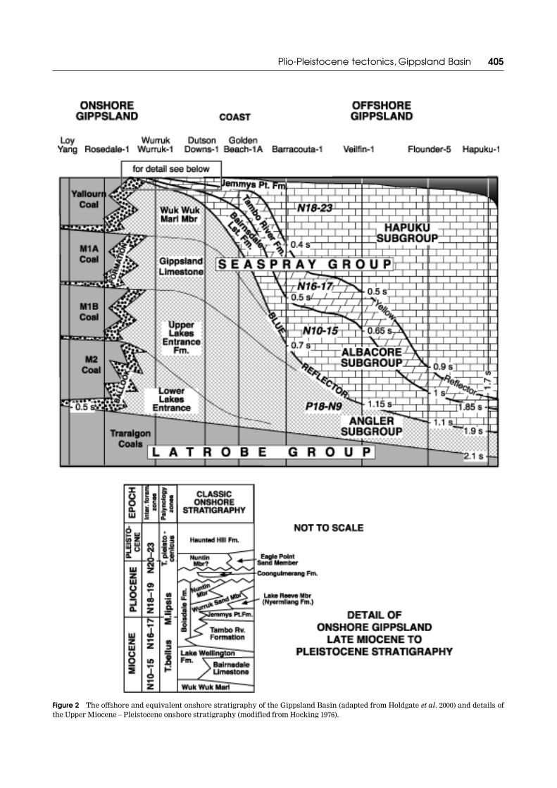
Figure 2
The offshore and equivalent onshore stratigraphy of the Gippsland Basin (adapted from Holdgate
et al
. 2000) and details ofthe Upper Miocene – Pleistocene onshore stratigraphy (modified from Hocking 1976).

406
G. R. Holdgate
et al.
shallow onshore stratigraphy with that found offshore; and(iii) provide a record of the shelf architecture, tectonics andgrowth history for this cool-water carbonate shelf over thepast 2.0 million years.
GIPPSLAND SHELF
General stratigraphy
The Gippsland Basin has been extensively studied, withmuch of the published literature focusing on the LatrobeGroup (James & Evans 1971; Hocking 1972, 1976; Abele
et al
.1976; Rahmanian
et al
. 1990). The overlying SeasprayGroup has been less extensively studied (Bernecker
et al
.1997; Holdgate & Gallagher 1997; Feary & Loutit 1998;Holdgate
et al
. 2000; Gallagher
et al
. 2003; Wallace
et al
.2002).
The marls and limestones of the Seaspray Group can besubdivided into three offshore subgroups and seven corres-ponding onshore formations (Figure 2). Because the top150–200 m of these beds is the main focus of this paper, onlythe Hapuka/Albacore Subgroups and their onshore faciesequivalents are described below. The offshore Middle toLate Miocene Albacore Subgroup is made up of bioclast-rich wackestone and packstone. This unit was deposited ina high-energy outer shelf to upper slope canyon environ-ment (Gallagher
et al
. 2001). The onshore facies equivalentto the Albacore Subgroup is the 15–25 m-thick BairnsdaleLimestone and the 33 m-thick Tambo River Formation. TheBairnsdale Limestone consists of limestone and limy marl,
and the Tambo River Formation consists of glauconiteshelly marl, marly limestone and shelly and ferruginousfine sandstone (Holdgate & Gallagher 1997): its inlandlateral facies equivalents are lower beds of the BoisdaleFormation. The Albacore Subgroup is overlain (probablydisconformably) by the Hapuku Subgroup with the contactapproximating to the Miocene–Pliocene boundary. TheHapuku Subgroup is characterised by basal quartz-richsiltstone overlain by carbonate-rich coarse bioclasticgrainstone
(Holdgate
et al
.
2000;
Gallagher
et al
.
2003).The onshore facies equivalent is the Jemmys Point Form-ation, which consists of up to 14 m of silty/shelly sandstonewith interspersed mica-rich siltstone (Murfitt 1997). Theinferred depositional environments of the HapukuSubgroup and Jemmys Point Formation become pro-gressively shallower up-section. The inland lateral equiva-lents of these Pliocene units are the upper beds of theBoisdale Formation.
Regressions during the Pliocene and Pleistoceneresulted in the deposition onshore of outwash fans, rivergravels and alluvium known as the Haunted Hill Form-ation (Jenkin 1968; Bolger 1991). Eustatic sea-level changes,coupled with tectonic reactivation of older compressionalstructures, have modified sedimentation in the present-daycoastal areas.
Regional oceanographic setting
The Gippsland shelf covers 15 000 km
2
, lies between 38 and41
�
S off the coast of southeast Australia, and is up to 100 kmacross. The curved morphology of its tapering shelf break
Figure 3
Seabed profiles across the Gippsland shelf at Transects A–A
�
and B–B
�
, incorporating the Late Quaternary sea-level curve(adapted from Smith 2002).

Plio-Pleistocene tectonics, Gippsland Basin
407
is principally determined by the occurrence of a largesubmarine canyon that reaches a maximum depth of4000 m (the Bass Canyon). The slope of the Gippsland shelfranges from 0.06
�
in water depths between 0 and 100 m, to0.3
�
between 100 and 200 m (Figures 3, 4). Slopes up to 6
�
occur at the shelf break at the head of the Bass Canyon(deeper than 200 m), but decrease to 0.6
�
at the bottom ofthe Bass Canyon at depths of
~
3500 m.Mean sea-surface temperatures for offshore Gippsland
vary from 12 to 16
�
C in winter and from 18 to 20
�
C insummer (Levitas 1982), i.e. it is a temperate or cool-waterregion
sensu
James (1997). The 15
�
C isotherm is at approxi-mately 100 m and the 10
�
C isotherm is at 400 m, with sea-sonal changes in temperature seldom observed below 200 mwater depth. Mean annual salinities across the Gippslandshelf are stenohaline and range from 35.2‰ at 200 m depthto 35.5‰ at 50 m (Levitas 1982).
Gippsland (euryhaline) lakes
A siliciclastic barrier system separates the Gippslandshelf from a series of brackish estuarine lakes in theonshore Gippsland area (Figure 1). The lakes occupy anarea of approximately 280 km
2
, with an average depth ofless than 9 m (Apthorpe 1980). The present lake systemformed in the late Pleistocene to Holocene behind sandbarriers and dunes of the Ninety Mile Beach (Jenkin 1968;Thom 1984). These lakes are euryhaline, with salinityvarying
from
0.3
to
5‰
where
rivers
enter
the
lakes
to
20–35‰ near Lakes Entrance (Apthorpe 1980). At LakesEntrance, the tidal range inside the channel is 0.6 m,whereas outside the channel it is greater than 1.2 m andthe tidal current has a maximum surface velocity of2.6 ms
–1
during ebb (Tan 1971).
Onshore Pleistocene terraces
The detailed mainly physiographic-based mapping of theonshore Gippsland Basin by Jenkin (1968) recognisestopographic-defined surfaces that correlate to Pleistoceneeustatic and tectonic events. This mapping is summarisedon Figure 1. However, it was difficult to relate the Pleisto-cene history based on the shelf and onshore subsurfacedata to the onshore history as interpreted by Jenkin (1968).This is probably because, at the time, Jenkin’s data lackedany definitive way of dating the events, except by way ofrelative surface levels and broad lithostratigraphic correl-ations.
PREVIOUS WORK ON THE GIPPSLAND SHELF
Surface sample collection
Over 100 seabed samples were collected on the
RV Franklin
and
Southern Surveyor
in September–October 1998 andApril 2000, respectively. Other seabed sampling programsinclude
San Pedro Bay
samples collected by David Taylor
Figure 4
Contour map of the Gippsland shelf showing the distribution and percentage of calcium carbonate on the seabed (adaptedfrom Smith 2002).

408
G. R. Holdgate
et al.

Plio-Pleistocene tectonics, Gippsland Basin
409
in 1968;
Kimbla
and
Sprightly
samples collected by theBureau of Mineral Resources (now Geoscience Australia)in 1973, and Gippsland Lakes samples collected by Marjo-rie Apthorpe in 1980.
Gippsland shelf facies maps
The first facies maps of the Gippsland shelf were based onthe
Kimbla
and
Sprightly
samples (Davies & Marshall 1972,1973; Jones & Davies 1983). These data together withresults from the
Franklin
and
Southern Surveyor
werecombined by Smith (2002) to produce a contour map ofpercentage calcium carbonate (Figure 4). Seven faciestypes were found on the Gippsland shelf (Smith 2002) thatshow in more detail a broad depth control on the occur-rence of the different facies types. Carbonate-poor siltysand is restricted to the Gippsland Lakes, medium tocoarse quartz sand is restricted to the inner shelf,molluscan–foraminiferal–peloidal silt to very fine sandoccurs on the upper slope, and
Globigerina
ooze occursfrom the middle to lower slope.
Shallow subsurface geology
Little has been published regarding the shallow sub-surface stratigraphy on the Gippsland shelf. Examples ofsparker seismic lines are given in Davies and Marshall(1973). Line drawings of sparker seismic across the adja-cent part of the New South Wales continental shelf aregiven in Davies (1979), but do not cross into the GippslandBasin. Deep-water line-drawings of seismic offshore fromthe Gippsland shelf are figured in Colwell
et al
. (1987). Essodrilled a number of engineering foundation bores on eachof the main oil and gasfields, recovering a series of punchcore samples from the upper 150 m of strata. The strati-graphy of these bores was not published in detail, althougha description of the dinoflagellate biostratigraphy isavailable for the Halibut, Mackerel and Marlin fields(McMinn 1992).
INVESTIGATION METHODS ON THE GIPPSLAND SHELF
Fourteen sediment piston cores below the Gippsland shelfseabed were obtained using equipment from the Univer-sity of Sydney (Keene 1998). The cores were logged formagnetic susceptibility, then split, logged for lithology,sampled for carbonate content, and age-dated using nanno-fossils. All the major Esso–BHP production platforms inthe Gippsland Basin have their foundations built into theupper 50 m of shelfal sediments (Figure 1). Shallowgeotechnical coring and sampling provides a nearlycontinuous record of the subsurface geology from theseabed to approximately 155 m—an interval not otherwisesampled by conventional oil-well drilling where the first
cuttings returns and geophysical logs are not usuallyobtained at depths shallower than 200 m. Samples wereavailable at approximate 3 m intervals from Barracouta-A,Snapper, Marlin, Tuna, Flounder-A, Halibut-A, Mackereland Kingfish-B platforms. Selected samples were analysedfor carbonate content, petrology, facies, foraminiferal andnannofossil ages.
Sparker seismic profiles were made along east to westand north to south shelf transects (Figure 1). Seismicdetails are outlined by Keene (1998). Detailed GeologicalSurvey of Victoria magnetic coverage of the GippslandBasin has been reconfigured to emphasise the shallowermagnetic signatures of the basin. This work provides apreviously unknown image of the offshore geology duringlower sea-level periods. Onshore bores and wells werelogged to obtain data on the immediate subsurface geologyin the Gippsland Lakes area, and onshore seismic profileshave been used to help correlate the stratigraphy betweenbores.
Grainsize estimations follow the Folk (1966) grainsizeclassification scheme. Seabed samples from the
RVSouthern Surveyor
cruise were also used (Harris
et al
.2000). Calcium carbonate percentages were obtained usingthe technique outlined in Carver (1971).
RESULTS FROM THE SUBSURFACE INVESTIGATION OF THE GIPPSLAND SHELF
Gippsland shelf piston cores
Fourteen piston cores were obtained along two traverselines across the Gippsland shelf from water depths rangingbetween 34 and 196 m (Figure 1). Generally, the degree ofpenetration was determined by the amount of thick shellhash and/or cemented calcarenite layers and varied from0.96 to 2.83 m. The core logs are shown for traverses A–A
�
and B–B
�
on Figure 5 (rock colours taken from Goddard
et al
. 1995), together with spot sample carbonate contentsand nannofossil dates. Magnetic susceptibility peaks ofsome of the cores are also shown.
Carbonate-poor, medium–coarse sand dominates theupper 1.5–2.0 m of the inner shelf (Figure 5, PC 4, 5, 10).Carbonate content decreases downwards through the sandto a minimum immediately above a basal gravellycompacted high-carbonate shell hash layer where furthercore penetration was limited. In some piston corescarbonate-rich coarse shell hash also occurs at the top.
Across the middle to outer shelf areas, carbonatecontent progressively increases in both facies to 70–80%(Figure 5, PC 6–8, 11–13) and then decreases to 65% on theupper slope (Figure 5, PC 16, 17). In PC 6 there is no sandlayer and the two shell-hash layers are separated at 0.75 mby a cemented 2 cm-thick calcarenite. Other cementedhigh-carbonate calcarenite horizons up to 3 cm thick occurin the lower shell-hash layer. The magnetic susceptibilityprofiles show magnetic highs around the boundarybetween the base of the sand facies and the top of the lowershell-hash layer.
Muddy, sandy and gravelly facies occur on the upperGippsland slope. The slope sediments are distinctly differ-ent in appearance from those of the shelf due to the higher
Figure 5
Piston core stratigraphy along Traverse Lines A–A
�
and B–B
�
(see Figure 1 for location). Also showing spot samplesfor percentage CaCO
3
, nannofossil ages and peaks for magneticsusceptibility.

410
G. R. Holdgate
et al.
component of grey muds, poorer sorting and lower carbon-ate content. The mud component is presumed to have acarbonate content. However, the three-layer stratigraphy isstill
present
down
to
water
depths
of
196 m
(Figure 5,PC 16), with high magnetic susceptibilities around theboundary between the sand facies and the basal gravellyshell hash. In contrast, cores from water depths between255 and 3334 m (the floor of the Bass Canyon) containedmainly mud and muddy sand >5 m thick, where slumpfeatures and graded turbidite-like beds are preserved.
Two nannofossil dates were obtained from the lowershell-hash layer in PC 6 (middle shelf) and PC 17 (upperslope) cores. Both belong to the CN14b subzone based onthe appearance of several species of
Gephyrocapsa
in theabsence of
Pseudoemiliania lacunosa
and
Emilianiahuxleyii. The absence of these two species is unlikelyto be environmental as they occur in several deeper watercore samples. Based on these dates, the lower hash layerhas a late Middle/Late Pleistocene age with the zonal agerange between 0.47 and 0.26 Ma (Thierstein et al. 1977;Berggren et al. 1980). The undated sand facies and upperhash layer in the upper part of the cores is interpreted torepresent deposition in Holocene times. This is based onthe upward increase in carbonate content, the highmagnetic susceptibilities at the base of the sand facies,and the modern-day foraminiferal faunas at the seabed(Smith 2002).
The base of the sand facies probably represents theearly Holocene transgression over an erosional hiatus cutduring glacial sea-level lows. The cemented calcarenitebands below this boundary may be the result of subaerialexposure across the shelf. A thin section of one calcareniteband at 72 cm in PC 7 contained abundant molluscanmoulds, indicating aragonite dissolution, weakly devel-oped meniscus cements of micritic carbonate, and afragment of what looked like ferruginous calcrete(Figure 6a). Meniscus cements indicate that the rock wasexposed to the vadose zone (i.e. above the water-table) andaragonite dissolution indicates that the rock was exposedto meteoric water.
Gippsland shelf foundation bores in the oil and gasfields
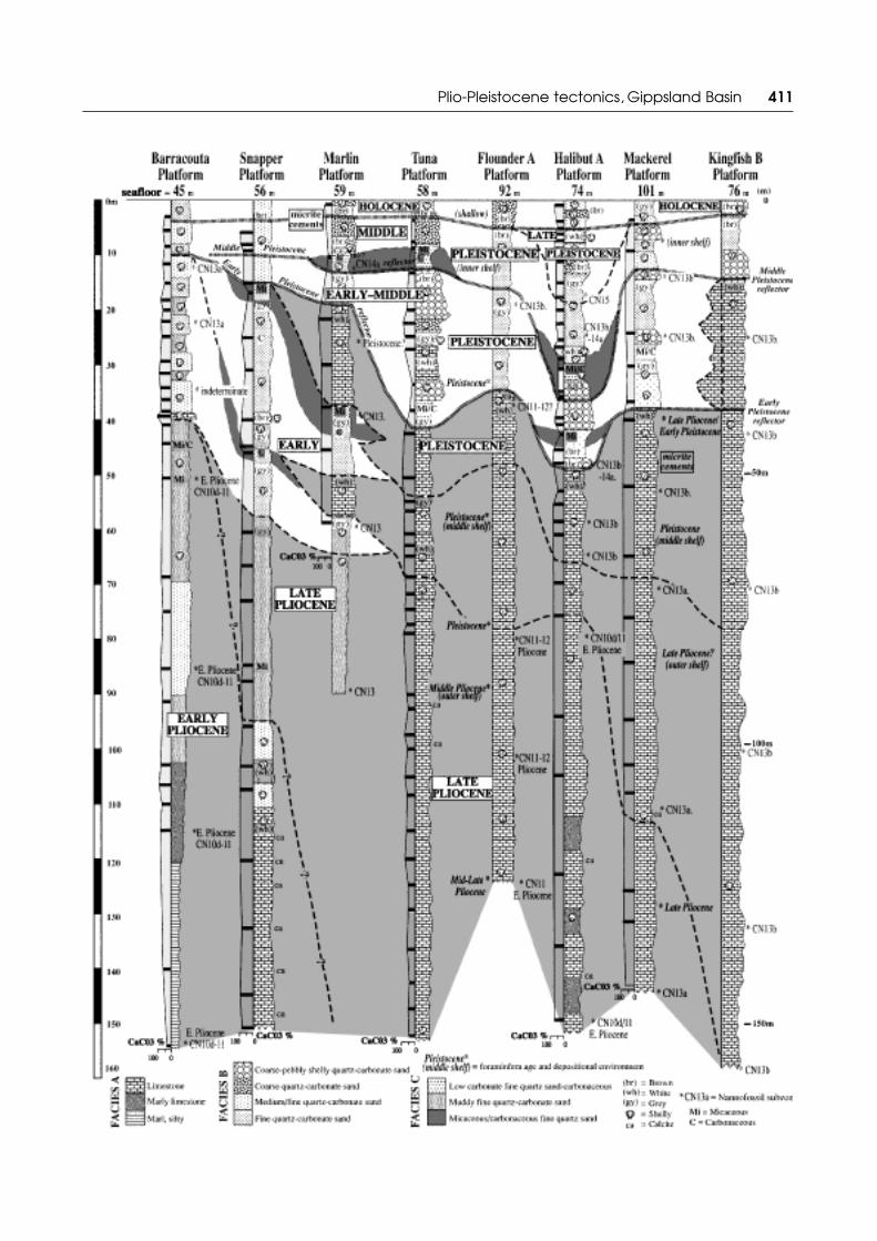
A stratigraphic correlation of the platform bores extend-ing from the inner shelf at Barracouta to the outer shelf atMackerel and Flounder fields is shown on Figure 7. The
Figure 6 Photomicrographs of lithologies from the shallow Gippsland shelf illustrating the effects of subaerial exposure. (a) Skeletalpackstone with moldic pore (M) produced by dissolution of an aragonitic bivalve. Clear equant calcite cements with meniscus textures(arrow) are also present in primary porosity; RV Franklin (1998) Piston Core 7, 72 cm. (b) Echinoderm fragment with clear equantcalcite cement displaying meniscus textures (arrow); Marlin foundation bore, 1.4 m. (c, d) Large intergranular pores with micriticcalcite cements having meniscus textures (arrows); Kingfish foundation bore, 24.2 m.
Figure 7 Foundation bore logs for the top 150 m of strata in themain offshore Gippsland Basin oil and gasfields. Subdivisionsbased on facies, CaCO3 content and biostratigraphic age. SeeFigure 1 for bore locations.
Plio-Pleistocene tectonics, Gippsland Basin 411

412 G. R. Holdgate et al.
carbonate content of samples is shown as graphed barlines, together with the results of the biostratigraphicdating. The lithologies found can be subdivided into fourcarbonate facies.
FACIES A
The deepest subsurface sediments comprise Facies A finesand to silt grainsize limestone and limey marl, prevalent50 m below the seabed to the total bore depths. Facies Ausually shows a gradual upward increase in carbonatecontent from 60 to 80% CaCO3 near the top. Clear equantand micritic cements with either isopachous or meniscustexture occur in the upper units of Facies A (e.g. at loglevel 52 m in Mackerel: Figure 7), indicating that theupper beds of this facies were exposed to meteoricwater and/or subaerial exposure. In Kingfish-B, FaciesA is as shallow as 15 m below the seabed, and includesmicritic calcite cements at 24.2 m (Figure 6c, d). Thebenthic foraminiferal assemblage in Facies A wasdeposited in outer shelf water depths (biofacies A ofSmith 2002).
FACIES B
In the inner shelf Barracouta and Snapper bores (between50 and 20 m sub-sea), Facies B comprises fine–coarsepebbly quartz–carbonate sand. In the middle to outer shelfbores at Marlin, Tuna, Flounder, Halibut, Mackerel andKingfish, Facies B grades laterally to carbonate-richFacies A limestone. In Facies B coarse to pebbly shellyquartz–carbonate sand also occurs between the firstsamples (approximately 3 m below the seabed) and ~30 mdepth. This facies thicken towards the outer shelf to 47 mbelow the seabed at Halibut. Facies B also occurs as thelower shell-hash layer in the piston cores. The carbonatecontent varies from 40 to 80% CaCO3. Clear equant andmicritic cements with either isopachous or meniscustextures occur in the upper units of Facies B (e.g. at loglevel 4.5 m in Marlin and log level 0.72 m in PC 7: Figure 6a,b). These cements indicate that the upper beds of thisfacies have been exposed to meteoric water and/or sub-aerial exposure. The benthic foraminiferal assemblages inFacies B sediments suggest deposition in middle to innershelf water depths (corresponding to biofacies B & C ofSmith 2002).
Figure 8 Seismic interpretation of sparker lines 14 (Traverse A–A�) and 21 (Traverse B–B�) showing the main reflectors, location andlogs of foundation bores and other well locations. See Figure 1 for location of lines.

Plio-Pleistocene tectonics, Gippsland Basin 413
FACIES C
Facies C comprises carbonate-poor fine quartz sand thatmay be carbonaceous and micaceous. This facies forms5 m-thick discontinuous horizons at various levels from 10to 50 m below the seabed. The carbonate content isgenerally <30–40% CaCO3. One prominent horizon occursfrom 30 to 40 m in Marlin and Tuna, and splits thecarbonate-rich Facies B limestone into two units. Benthicforaminifers are rare and the assemblage has a low diver-sity in this facies, representing deposition ranging frominner shelf to the Gippsland Lakes euryhaline environ-ment (Mays 2001; Smith et al. 2001). Based on the laterallydiscontinuous nature of this facies, its low carbonatecontent, its relatively high carbonaceous content and itsforaminiferal biofacies, Facies C is interpreted to repre-sent deposition in an estuarine, coastal lake or lowerfloodplain fluvial environment.
FACIES D
Facies D comprises low carbonate silty and clayey marlthat occur from 120 to 155 m at Barracouta. In general, thecarbonate content is less than 40% CaCO3. Facies D yieldsthe oldest dates (Early Pliocene) of all the foundationbores. The benthic foraminifer assemblage of this faciessuggest deposition in the outer shelf water (biofacies A ofSmith 2002).
SUMMARY
Dating the facies was carried out using nannofossils andforaminifers, although the nannofossils provide betterbiostratigraphic resolution for the Pliocene to Holoceneperiod compared to the foraminifers. Thirty-five nanno-
fossil dates from the various facies were obtained byShafik (2000), supported by Mays’ (2001) and Smith’s (2002)foraminifer dates from Barracouta, Tuna, Flounder andMackerel. The interval between horizons sampled for bio-stratigraphy was 20–40 m in Barracouta, Marlin, Flounder,Halibut, Mackerel and Kingfish. The oldest strata datedwere Early Pliocene in age (belonging to nannofossilsubzone/zone CN10d–CN11) at 154.5 m in Barracouta(Facies D), and the youngest date obtained was LatePleistocene (probably nannofossil zone CN15) for loglevel 17.5 m in Halibut (Facies C). The biostratigraphicresolution was relatively poor as a result of the shelfalnature of the facies because nannofossils and planktonicforaminifers were relatively rare. A shelfal environmentfor most of the carbonates was interpreted based onbenthic foraminiferal assemblages (Smith 2002). Thepalaeoenvironments for the four facies ranged from: outershelf for Facies A at bore depths between ~150 and 80 m;middle shelf for Facies B at bore depths from 80 to ~40 m;and inner shelf for Facies C at bore depths from 40 to ~2 m(Figure 7).
Gippsland shelf seismic profiling
The RV Franklin (1998) sparker seismic acquisition(Figure 1) includes two dip lines shot along samplingTraverses A–A� and B–B� (Figure 8) and two strike linesacross the middle and outer continental shelf (Figures 9,10). The upper strata of the continental shelf down to 0.2 sTWT (two-way time) (~40 m) below the seabed can bedistinguished. Below 0.2 s (~40 m), strong seabed multiplestend to interfere with the seismic quality.
On Figures 8–10, the top 20–40 m can be subdivided intoan upper series of closely conformable reflectors that areapproximately parallel to the seabed and thicken from 20 m
Figure 9 Seismic interpretation of sparker line 22 showing the main reflectors, location and logs for Tuna and Marlin foundation boresextrapolated onto line. See Figure 1 for location of lines.
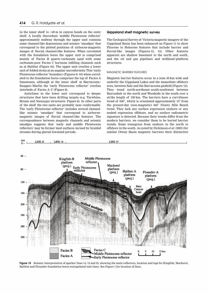
414 G. R. Holdgate et al.
in the inner shelf to >40 m in canyon heads on the outershelf. A locally discordant ‘middle Pleistocene reflector’approximately midway through the upper unit containssome channel-like depressions and seismic ‘smudges’ thatcorrespond to the plotted positions of airborne-magneticimages of fluvial channel-like features. When correlatedwith the foundation bores the upper unit is comprisedmainly of Facies B quartz–carbonate sand with somecarbonate-poor Facies C horizons infilling channels suchas at Halibut (Figure 10). The upper unit overlies a lowerunit of folded strata at an angular unconformity. This ‘earlyPleistocene reflector’ boundary (Figures 8–10) when correl-ated to the foundation bores comprises the top of Facies Alimestones, although at the inner shelf at Barracouta/Snapper/Marlin the ‘early Pleistocene reflector’ overliesinterbeds of Facies A–C (Figure 8).
Anticlines in the lower unit correspond to deeperstructures that have been drilling targets (e.g. Tarwhine,Bream and Nannygai structures: Figure 8). In other partsof the shelf the two units are probably near conformable.The ‘early Pleistocene reflector’ includes several channel-like seismic ‘smudges’ that correspond to airborne-magnetic images of fluvial channel-like features. Thecorrespondence between magnetic channels and seismicsmudges suggests that ‘early and middle Pleistocenereflectors’ may be former land surfaces incised by braidedstreams during glacial lowstand periods.
Gippsland shelf magnetic survey
The Geological Survey of Victoria magnetic imagery of theGippsland Basin has been enhanced on Figure 11 to showPliocene to Holocene features that include barrier andfluvial-like images (Figures 12, 13). Other featuresapparent are shallow basement to the north and south,and the oil and gas pipelines and wellhead/platformstructures.
MAGNETIC BARRIER FEATURES
Magnetic barrier features occur in a zone 50 km wide andunderlie the Gippsland Lakes and the immediate offshorearea, between Sale and the Barracouta gasfield (Figure 12).They trend north-northeast–south-southwest betweenBairnsdale in the north and Woodside in the south over astrike length of 120 km. The barriers have a curvilineartrend of 030�, which is orientated approximately 15� fromthe present-day (non-magnetic) 045� Ninety Mile Beachtrend. They lack any surface expression onshore or anyseabed expression offshore, and no surface radiometricsignature is detected. Because their trends differ from themodern barriers, we consider them to be buried barriertrends. Some transgress from onshore in the north tooffshore in the south. As noted by Dickinson et al. (2001) forsimilar Otway Basin magnetic barriers their distinctive
Figure 10 Seismic interpretation of sparker lines 14, 15 and 23, showing the main reflectors, location and logs for Kingfish, Mackerel,Halibut and Flounder foundation bores extrapolated onto lines. See Figure 1 for location of lines.

Plio-Pleistocene tectonics, Gippsland Basin 415
curvilinear geophysical expression suggests iron oxide(ferricrete) cementation, characteristic of a regressivesequence of shoreface strandline deposits. These featuresare like the correlative Pliocene Parilla Sand and HansonPlain strandline systems in the Murray and Otway Basins(Brown & Stephenson 1991; Kotsonis 1996: ; Roy et al. 2000;Dickinson et al. 2001, 2002). Similar to the Hanson Plainexamples, the magnetic signature often has a closelyspaced double pattern that probably represents ferricretedevelopment in the swales on each side of a dune ridge. Themagnetic barriers are absent from the shelf area immedi-ately south of Lakes Entrance, and around the Tarwhinewell. This is interpreted to be the result of uplift anderosion.
Onshore, the barriers are absent northeast of theMitchell River where shallow and outcropping basementrocks occur. Elsewhere they can be traced across the Barag-wanath Anticline to the south, where they overlie shallowEocene coal measures and/or Miocene Gippsland Lime-stone. Here, the upper units of the barriers probablyoutcrop in several sand quarries on the edge of theRosedale Monocline. Coal exploration bores drilled acrossone magnetic lineament encountered a barrier sandsequence with a basal ferruginous-cemented intervaloverlying the Miocene Gippsland Limestone and EoceneLatrobe Valley Group coal measures (Figure 14). Younger
movements on the Baragwanath Anticline have exhumedthe Pliocene barriers.
A weak magnetic barrier lineament set that trends east-northeast occurs south of the Bream–Kingfish oilfieldsarea and north of Tuna field (Figure 12). A similar trend toa (non-magnetic) geomorphic dune set occurs in theonshore Stratford to Bairnsdale area and these features areinterpreted to be last-glacial dune blowouts from the AvonRiver flood plain (Jenkin 1968). By analogy we suggest thatthe offshore weakly magnetic lineaments were caused bywind-directed dune blowouts on the Gippsland shelf duringPleistocene lowstands. This is because, in general, theirpositions occur adjacent to the major fluvial trends (cf.Figures 12 and 13).
MAGNETIC FLUVIAL FEATURES
Magnetic fluvial features that show overlapping meanderchannels and oxbow loops underlie the Gippsland Lakes,and all of the offshore Gippsland shelf area from Sale to thecontinental slope edge (Figure 13). These features trendsouth-southeast offshore and are related to the modern-dayrivers in Gippsland with dominant trends coming from theSnowy River, Ironstone Creek, Nicholson–Tambo Rivers,Mitchell River, Avon–Perry Rivers, and the Thompson–Macalister Rivers/Merrimans Creek. Some of the fluvial
Figure 11 Airborne magnetic image of the Gippsland Basin exemplifying the Pleistocene barrier and river systems (courtesy of theGeological Survey of Victoria). The position of the modern coastline, lakes and rivers are shown; also prominent are the offshore oiland gas platforms and associated pipelines. Shallow basement features to the north and south obscure the Quaternary features.

416 G. R. Holdgate et al.
Fig
ure
12
Mag
net
ic b
arri
er fe
atu
res
of t
he
Gip
psla
nd
Bas
in t
oget
her
wit
h t
he
onsh
ore
geol
ogy
and
phys
iolo
gy.

Plio-Pleistocene tectonics, Gippsland Basin 417
Fig
ure
13
Mag
net
ic fl
uvi
al fe
atu
res
of t
he
Gip
psla
nd
Bas
in t
oget
her
wit
h t
he
onsh
ore
geol
ogy
and
phys
iolo
gy.

418 G. R. Holdgate et al.
trends have a stronger magnetic signature. Together withthe overlapping of meander loops, this suggests severalhorizons of different ages for these deposits. Ferruginouscementation near channel bases may cause the fluvialmagnetic signatures. Like the magnetic barriers, thesefeatures have no recent geomorphic expression onshore orbathymetric expression offshore, but in the Bairnsdale toLakes Entrance area they appear to reflect the gross strikeof the underlying Palaeozoic rocks. In addition, theironshore trends are more southerly than the east-orientated modern rivers (with the exception of someweakly magnetic channels beneath the Mitchell Riverfloodplain). We consider them to represent earlier under-lying river trends that have been cemented by iron oxide(ferricrete), characteristic of periods of floodplain depo-sition that extended across the continental shelf duringglacial lowstands. They are notably absent in an offshorearea to Lakes Entrance, and around the Barracouta toTarwhine fields, probably because of tectonic uplift andaccompanying erosion, or tectonic uplift and fluvialbypass. Younger sediments overlie the equivalent levels inthese areas. Where the sparker lines of the RV Franklin
survey intersect these features, they appear as <500 m-wide seismic ‘smudges’ from 20 to 40 m below the presentseabed (Figures 8, 9). In the outer shelf areas the fluvialfeatures swing southeast towards Bass Canyon feederbranches along the continental shelf edge where seismicdata show a thicker sequence of Pleistocene age(Figure 10).
Onshore, the magnetic fluvial features are mostlyabsent beneath the Haunted Hill Formation terracesbetween Stratford and Bairnsdale, although they appear onthe southern edge of the terraces where they have asoutherly orientation beneath the Gippsland Lakes.Magnetic channels in line with the Avon/Perry andThompson/Macalister Rivers appear to trend south acrossthe Baragwanath Anticline, although their signatureappears to be absent along the anticline crest. One mag-netic channel of the Thompson–Macalister–MerrimansRiver system was intersected in the Gifford-14 bore at loglevel 88 m near Seaspray (Figure 15). Their absence fromthe Baragwanath Anticline crest suggests that they havebeen eroded from this feature during subsequent upliftperiods and, therefore, are younger than the magnetic
Figure 14 Diagrammatic bore log cross-section along the Baragwanath Anticline near Longford, showing stratigraphy of the upper50 m of section. The Pliocene barrier sands are shown in relation to the Gippsland Limestone and Latrobe Valley Group. See Figure 12for location of section.

Plio-Pleistocene tectonics, Gippsland Basin 419
barriers that are still present. Where the fluvial andmagnetic barriers co-occur spatially, it appears they aretwo stratigraphically unrelated systems because they donot show interference and the barriers are thought to beolder than the rivers.
Onshore Gippsland Lakes area stratigraphic drilling
In the onshore Gippsland Lakes area, four stratigraphicbores shown on Figure 1 have good core recovery from theupper 160 m of Pliocene to Holocene strata. Logs of thesebores are shown on Figure 15 together with their strati-graphic correlation, principle facies, depositional environ-ments and ages.
Outcrops of marine carbonates and barriers of thePliocene Jemmys Point Formation occur at LakesEntrance and Red Bluff, and have equivalent ages to thetop of Facies A in the offshore Barracouta bore, and arealso interpreted to be the same age as some of the magneticbarriers in the Gippsland Lakes area (Figure 12). TheJemmys Point Formation at Lakes Entrance and Red Bluffhas been uplifted relative to the same units that occur inbores in the Lake Wellington/Seaspray Depressions. In thedepressions the Jemmys Point Formation top-of-the-barrier sequence in Boole Poole-1 is at –40 m, Bengworden
South-6 at –102 m, Nuntin-2 at –92 m (disconformablyoverlies Upper Miocene Tambo River Formation), andGiffard-14/15 at –110 m. Uplift of the barriers on theBaragwanath Anticline to +50 m (Figure 14) occurs off thesection line between Nuntin-2 and Giffard-14/15.
Overlying the Pliocene barriers are a series of inter-bedded fluvial–lacustrine and barrier sequences up to110 m thick (Figure 15). The initial ferruginous cementedcoarse to pebbly sand (Fluvial 1) we consider to be oneof the sources for the fluvial magnetic signatures onFigure 13, and their pervasive ferruginous cementationwas probably caused by periods of prolonged subaerialexposure. In outcrop at Red Bluff, similar ferruginous-cemented coarse fluvial sediments are known as theNyerimalang Formation. A stratigraphically higherferruginous coarse–pebbly fluvial sequence—Fluvial 2(between log levels –40 and –70 m in Bengworden South-6)—is interbedded with lacustrine silty clay facies.
The lower Gippsland Lakes 1 beds in Figure 15 repre-sent a Late Pliocene – Early Pleistocene lacustrine faciesfor this area and generally occur from –70 to –90 m loglevels. They include upper beds of the Nuntin Clay Member(of the Boisdale Formation) in the type Nuntin-2 borewhere they overlie (at 84 m) coals and fluvial sediments ofprobable Late Miocene age C. bifurcatus spore–pollen zone(Partridge 1999). The upper 40 m of the Nuntin Clay
Figure 15 Logs of the upper 150 m in four bores in the Gippsland Lakes area, showing core intervals and lithologies, stratigraphiccorrelations of the main depositional units and facies. See Figure 1 for location of section.

420 G. R. Holdgate et al.
Member comprises 25 m of calcareous clay and mud(Gippsland Lakes 2 unit in Figure 15) that in BengwordenSouth-6 contains common molluscs such as the brackishwater Anadara trapezia. This taxon is considered to havefirst appeared in southern Australian estuaries aroundca 0.22 Ma (Murray-Wallace et al. 2000). In BengwordenSouth-6 bore two estuarine periods are present interbeddedby fluvial units at 35 m. At log level 20 m this estuarinefacies is overlain by a younger Holocene fluvial–lacustrineand barrier sequence, which in adjacent bores has beendated by C14 as <10 ka BP (Thom et al. 1981). In theGippsland Lakes, sub-bottom profiling and vibrocore dataindicate that the lacustrine mud deposition continuesthrough to the present day.
Onshore Gippsland seismic
In general in the Gippsland Basin petroleum seismicsurvey, data quality is poor for the upper 0.3 s (most rele-vant interval to this study). The exception to this is the1988 24-fold vibroseis survey by TCPL Resources completedin the Sale area. This survey provided good images of theupper 0.3 s with the most useful dip line of the survey,TR88-1 (Figure 16), extending southeast for 15 km betweenthe Thompson River to near Lake Wellington (Figure 12).This is also an area where a number of groundwater andstratigraphic bores provide good subsurface controls forthe seismic data.
On seismic line TR88-1 (Figure 16), barrier-sand build-ups in the upper 0.3 s prograde southeast into marinelimestone and marl. Flat-bedded back barrier lacustrineclay intervals occur behind (northwest) each barrier. Eachprograde is diachronous, oversteps to the southeast andforms a regressive series. Positions where prominent sandbarrier buildups occur, such as at Nuntin-5 bore, also
coincide with areas where prominent magnetic barrierlineaments occur (Figure 12). Foraminiferal age datafrom bores indicate that the sand barriers at WurrukWurruk-1/13 to the northwest have a foraminiferal zoneage of N8a (early Middle Miocene) and are part of theupper Gippsland Limestone (Holdgate & Gallagher1997). They progressively young to the southeast, and atNuntin-2/6 are foraminiferal zone N16–17 (Late Mioceneage), belonging to the Tambo River Formation. This trendis thought to continue beneath the Gippsland Lakes, andoffshore sparker line 21 shows southeast prograding out tothe Barracouta area (Figure 8). The Barracouta area alsocorresponds to the maximum offshore extent of themagnetic barriers where age data suggest the progradinginterval could be Early Pleistocene in age. Therefore, theregressive series of seismic and magnetically definedbarriers appear to have first developed in the Sale areain the Middle Miocene, then moved progressivelysoutheast through the Late Miocene to near LakeWellington, underlay the Ninety Mile Beach area by theEarly Pliocene, prograded offshore by the Late Pliocene,and reached the Barracouta area by the Early Pleistocene(Figure 12).
DISCUSSION
A summary of the relationship between the onshore andoffshore stratigraphy of Gippsland for the past 2.0 millionyears is shown on Figure 17. Also plotted is the compositeO18 isotope record (Shackleton et al. 1995; Carter et al.1999), magnetic record and nannofossil zones for com-parison. The detailed lithostratigraphic and biostrati-graphic data can be used to establish Late Neogenetectonic and eustatic records for the Gippsland Basin.
Figure 16 Seismic interpretation for seismic line TR88-1 between Sale and Lake Wellington showing the main reflectors andinterpreted facies, location of key bores and extrapolated ages for the main units. See Figure 12 for location of seismic section.

Plio-Pleistocene tectonics, Gippsland Basin 421
Age of the offshore Gippsland shelf Plio-Pleistocene succession
Biostratigraphic ages follow broad lithostratigraphic sub-divisions as the following examples show.
Facies A between 40 and 150 m below the seabed yieldsnannofossil ages of Middle to Late Pliocene (zones CN11and 12) and Early Pliocene (zones CN10d and 11) inBarracouta. However, the horizons that yield EarlyPliocene nannofossil ages near the base of Flounder andMackerel bores also contain contradictory Late Pliocene
foraminiferal ages. It is important to note here thatmoderate to poor preservation of key nannofossil specieswas noted. Therefore, in these instances the nannofossilages are suspect and the foraminiferal ages are used. Theinterval below ~40 m below the seabed also corresponds tothe deepest outer shelf foraminiferal biofacies A of Smith(2002).
Facies B between ~50 and 20 m below the seabed inBarracouta and Snapper yielded poorly preserved nanno-fossils of probable Early Pleistocene age (subzones CN13aand 13b). Carbonate-poor Facies C also first occurs in the
Figure 17 Summary diagram rel-ating the onshore and offshoreGippsland Basin Upper Pliocene –Pleistocene stratigraphy placedalongside the composite isotoperecord with isotope stages (afterShackleton et al. 1995; Carter et al.1999) together with the magneticzones and nannofossil zones.

422 G. R. Holdgate et al.
Early Pleistocene (subzones CN13a and 13b) in the Snapperbore at 46 m and in Marlin bore at 38 m (Figure 7). Theequivalent Facies A intervals between ~75 and 30 m belowthe seabed in Tuna, Flounder, Halibut, Mackerel andKingfish bores also yield Early Pleistocene ages (subzonesCN13a and 13b). This age is confirmed by the appearanceof the key index Pleistocene foraminiferal species Globoro-talia truncatulinoides at 78 m in Flounder. This intervalwas deposited at middle shelf (50–100 m) palaeodepths(biofacies B of Smith 2002). These Early Pleistocene agesall underlie the ‘early Pleistocene reflector’ and occurwithin the folded lower unit (Figures 8–10). Early to MiddlePleistocene ages (nannofossil subzones CN13b–14a) wereobtained just above the ‘early Pleistocene reflector’.
Early to Late Pleistocene ages (subzones CN13b–14aand zone CN15) were obtained for the upper 40 m belowthe seabed principally in Facies B, and in part of Facies Ain Kingfish. This interval was deposited at inner shelf(0–50 m) palaeodepths (biofacies C of Smith 2002), withmany discontinuous horizons of carbonate-poor Facies C.This interval is also characterised by the coarsest sand topebbly Facies B horizons. Based on the nannofossil agedata it is inferred that over much of the Gippsland shelf theMiddle Pleistocene extends to within a few metres of theseabed, this is in turn overlain disconformably by a veneerof Holocene carbonate sand and shell hash.
The upward increasing carbonate content in theHolocene sand immediately above this disconformityhorizon (with evidence for subaerial exposure) is inter-preted to have formed during the post-glacial sea-level risefrom ca 10–6 ka BP, with the upper shell hash represen-tative of the past 6000 years of relatively stable sea-level. Ifso, this provides for a total Holocene sedimentation rate ofup to 23 cm/1000 y (Figure 5, PC 5)—a slower depositionalrate than the middle shelf mud on the New South Walesshelf (Thom & Roy 1985).
The piston cores show similarities to the ‘shaved shelf ’model of the Great Australian Bight (James et al. 1994). Inthis model earlier highstand deposits, such as the lastinterglacial, are eroded completely during the last glaciallowstand period, and on wave-dominated high-energyplatforms sedimentation rates stay low. On the Gippslandshelf the youngest carbonate facies appears to be, ingeneral, around 0.2 Ma, and is overlain by a Holocenecarbonate–siliciclastic veneer. Therefore, a period of sub-aerial weathering and erosion appears to have dominatedthe Gippsland shelf history over the past 0.2 million years.By contrast, cores collected by RV Franklin cruise on theGippsland slope and Bass Canyon floor show that LatePleistocene to Holocene nannofossil carbonate sedimentsare present. This indicates that sedimentation over thepast 0.2 million years occurred in deeper waters wheresedimentation rates are higher and where preservationbelow wave-base was more complete.
Age of the onshore Gippsland Lakes Plio-Pleistocene succession
The lower Gippsland Lakes 1 unit (Figure 15) representssome of the earliest Pleistocene lacustrine facies for theGippsland Lakes area. The strata overlie ferruginousLower Pliocene units that include the Jemmys Point
Formation, Jemmys Point sand barriers and Pliocene –Lower Pleistocene fluvial gravels of the NyerimalangFormation. In some bores the Gippsland Lakes 1 unitunconformably overlies Upper Miocene Boisdale Form-ation (e.g. at Nuntin-2: Figure 15). Offshore the equivalentage clastic progradation units are as young as the earliestPleistocene (nannofossil subzone CN13a) and these pro-gradational Facies B and C extend out to Barracouta andSnapper (Figure 7).
The interbedded barriers-1 and fluvial-1/fluvial-2 unitsrepresent the main period for magnetic channel develop-ment both onshore and offshore. We consider ferruginouscementation continued in the coarser channel units untilthe Late Pleistocene at ca 0.25 Ma. Calcareous clay and mud(Gippsland Lakes 2 unit) post-date this age and are mainlyconfined to the onshore region behind the relatively recentprecursors of the modern Ninety Mile Beach barrier. Therelative scarcity of post-0.25 Ma siliciclastic sediment onthe Gippsland shelf indicates that Late Pleistocene fluvialsedimentation was largely trapped behind the Ninety MileBeach barrier during sea-level highstands, but might havebypassed the shelf during sea-level lowstands, and wasdeposited as turbidites on the Gippsland slope and into theBass Canyon.
Ages of the magnetic barriers
On the seismic line (Figure 16) near the Nuntin-5 bore,stacked barrier sequences occur within 0.05 s (TWT) of thesurface. This position corresponds to the maximum inlandextent of the magnetic barrier lineaments shown onFigure 12. Ferruginous cementation of this barrier atNuntin-5 as a result of prolonged subaerial exposureprobably caused the magnetic signature. Northwest of thisbarrier sequence are thick units of lacustrine clay inSale-15 and Wurruk Wurruk-1/13 bores referred to as theNuntin Clay Member of the Boisdale Formation (Hocking1976). Southeast of Nuntin-5, lacustrine clays overlie andonlap the barrier, and in the Nuntin-2/6 bores were alsoincluded as part of the Nuntin Clay Member (Hocking 1976)(Gippsland Lakes 1 unit on Figure 15). As the two lacus-trine sequences are unconnected and are separated by aseismic disconformity along the top of the Tambo RiverFormation barrier, a redefinition of this unit is required.This seismic disconformity has also previously been inter-preted as a tectonic boundary at the Miocene–Plioceneboundary (Dickinson et al. 2001, 2002).
We believe this southeastwards progradational faciespattern continues to the coast and offshore. If this is thecase then it is probable that Jemmys Point Formationbarriers should appear east of Nuntin-2/6 corresponding toa group of strongly magnetic barriers through theBengworden South-6 bore (Figure 12). These lineamentsshow a slight difference in curvilinear orientation to thoseof the Tambo River Formation, but coincide with themaximum inland extent of the Jemmys Point Formation.The barrier systems appear to continue to young towardsthe southeast and offshore because at Barracouta, at thepoint of maximum regression, they are dated as earliestPleistocene (nannofossil subzone CN13a: Figure 7). Thepresence of the Nuntin Clay Member/Gippsland Lakes 1beds underlying the modern Gippsland Lakes and Ninety

Plio-Pleistocene tectonics, Gippsland Basin 423
Mile Beach also implies that the equivalent barrier suc-cessions had moved offshore by the Late Pliocene to EarlyPleistocene. The maximum offshore extent of magneticbarriers occurs at Barracouta because Facies B inner shelfcarbonates of Late Pliocene – Early Pleistocene (nanno-fossil zone age CN 13) are only found seawards of thesefeatures (Figures 7, 12).
Tectonics, unconformities and the ‘shaved shelf’ concept
The inner shelf appears to contain a highly condensed ormissing record of Early to Middle Pleistocene age (e.g.Barracouta: Figure 7) because of the prograding nature ofthe shelfal facies, together with the occurrence of uncon-formities such as the ‘early Pleistocene reflector’. In themiddle to outer shelf areas the succession is morecomplete, extending to the late Middle Pleistocene (nanno-fossil subzone CN14b) with a Holocene veneer. At the headof the Bass Canyon at Halibut, Early to Late Pleistocenestrata (nannofossil subzone CN13b to zone CN15) arepresent above the ‘early Pleistocene reflector’ (Figure 7).
With the exception of the deeper water canyon heads,such as that at Halibut, tectonic folding and subaerialerosion appears to have locally affected parts of thestratigraphic section below the ‘early Pleistocenereflector’. The oldest beds deposited on the ‘early Pleisto-cene reflector’ surface are carbonate-poor Facies B andFacies C of nannofossil subzones CN13b–14a. Folding,therefore, appears to have ceased at ca 1.0 Ma if a medianage point for the CN13b–14a nannofossil subzones isassumed. This time corresponds to the first appearance onthe shelf (above the ‘early Pleistocene reflector’) of mag-netic fluvial channels (and seismic ‘smudges’) and thickcarbonate-poor Facies C lenses. We infer from this that theearliest magnetic channels could correspond to the IsotopeStage 22 lowstand (Figure 17). However the majority of themagnetic channels appear on the shelf immediately abovethe younger ‘middle Pleistocene reflector’ and, therefore,date to the Middle Pleistocene (middle part of the nanno-fossil subzone CN14a). Therefore, these features couldrelate to the Isotope Stage 16 lowstand between 0.7 and0.6 Ma (Figure 17). The latest magnetic channels may beas young as nannofossil zone CN14b, possibly formedduring Late Pleistocene lowstand Isotope Stages 10 and 8(0.4–0.25 Ma) (Figure 17).
The Pleistocene sedimentary record of much of theGippsland shelf to water depths of 190 m, from the dataavailable, appears to largely cease at around 0.25 Ma.Piston core data shows a significant hiatus between theupper few metres of Holocene carbonates and a weatheredsurface on a late Middle Pleistocene nannofossil subzoneCN14b (or older) carbonate unit (Figure 5). Evidence ofcontinuous sediment accumulation after the late MiddlePleistocene was only found at the head of the Bass Canyon.We suggest that the high-amplitude lowstand and high-stand eustatic sea-level changes during Late PleistoceneIsotope Stages 6 through to Stages 4 and 2 eroded much ofthe shelf (with the exception of the deeper canyon heads),exposing the carbonate surfaces to subaerial weatheringprocesses. This surface is possibly equivalent to the shavedshelf surface of James et al. (1994) in other southern
Australian basins. The Gippsland shelf became sedimentstarved during the Late Pleistocene. During highstands,fluvial sediments were confined to the developing Gipps-land Lakes systems behind Late Pleistocene (Ninety MileBeach–type) barriers, and during lowstands the sedimentsbypassed the shelf and were deposited as turbiditesthrough canyon heads onto the slope and Bass Canyon. Inbetween, high wave-energy transgressions and regressionsacross the shelf shaved the shelf clear of unconsolidatedhighstand deposits down to exposed subaerial cementedsurfaces that were more resistant to erosion.
Association between tectonics and the magnetic fluvial channels in the onshore succession
In contrast to the post-1.0 Ma tectonically quiescent phaseoffshore, folding onshore appears to have continued intothe late Middle Pleistocene (ca 0.5 Ma) or later. Magneticfluvial channels of the Thompson/Macalister/LatrobeRiver system can be seen to cross over the modern geo-morphic expression of the Baragwanath Anticline and itsnorth-bounding Rosedale Fault, and continue southwardsoffshore at Seaspray (Figure 13). Uplift of the BaragwanathAnticline (a feature that is elevated along its crest from30 to 60 m above the present-day Latrobe River flood-plain) has resulted in the erosion of the magnetic fluvialchannels and exhumed the underlying Pliocene barriers(Figures 12, 14). Because of this uplift the modernThompson, Macalister and Latrobe Rivers have beendiverted eastwards to the Gippsland Lakes. As we inferthat the magnetic channels that cross the BaragwanathAnticline are likely to be Early to Middle Pleistocene, as inthe offshore, then the youngest age of uplift post-dates thistime. The development of the Gippsland Lakes 2 unit(based on the first occurrence of the estuarine bivalveAnadara trapezia) and Ninety Mile Beach barriers wouldalso, in general, post-date this uplift. Therefore, the lastuplift on the Baragwanath Anticline could be slightly olderthan the 0.2 Ma age obtained for the Gippsland Lakes 2beds. In contrast, the Early to Middle Pleistocene upliftwas of the order 30–60 m relative to the modern floodplainwith an additional 30–40 m of subsidence taking placebeneath the Gippsland Lakes area (top of fluvial-3:Figure 15). This provides for a total Rosedale Faultmovement of between 60 and 100 m over the Early toMiddle Pleistocene (1.5–0.25 Ma), or between 5 and 8 cm/1000 y.
Quaternary fluvial magnetic signatures on other continental shelves
A similar suite of fluvial magnetic signatures to the Gipps-land shelf occurs in the southwest Joseph Bonaparte Gulfin northwest Australia (Clarke & Ringis 2000). Theseappear to be another published example where detailedaeromagnetic data have been used to reveal Quaternarylowstand fluvial distributions on the Australian contin-ental shelf. The scarcity of this type of data is due to acombination of factors including: (i) detailed aeromagneticdata are not, in general, applied in offshore studies; (ii)detailed aeromagnetic surveys as collected over theGippsland Basin and northwest Australia shelf margins

424 G. R. Holdgate et al.
are relatively recent and expensive, and tend to be targetedat petroleum or mineral exploration activity; and (iii) agood contrast needs to exist between the magneticsiliciclastic features and high-carbonate (non-magnetic)surrounding sediments. These factors occur in the JosephBonaparte Gulf where detailed aeromagnetic surveys indi-cate palaeovalleys off the Ord, Berkeley and ThorburnRivers (Gunn et al. 1995a, b) that were later investigated fordetrital diamond deposits (Clarke & Ringis 2000). Themagnetic signature was thought to result from discontin-uous concentrations of detrital magnetic material in thethalwegs of the channels. However, correlation betweenmagnetics and the (relative to Gippsland) more detailedboomer seismic surveys were not always good because ofsuperimposition of different generations of channel, and alack of magnetic grains in some channels. We presume thisis also the case in Gippsland if more detailed sparker/boomer seismic surveys were to take place. Our data sug-gest multiple channel generations and variable magneticintensities, although we consider that ferruginous channelfill is more likely to be causing the magnetic signature. TheGippsland shelf examples are also older than the JosephBonaparte Gulf examples that are mainly dated to the LatePleistocene last glacial lowstand, implying an ageingfactor to the degree of cementation in Gippsland. We con-clude that magnetic surveys should be useful to discernQuaternary lowstand fluvial and barrier features on manyother parts of the carbonate shelves of the Australiancontinental margin.
CONCLUSIONS
The study combines bore, piston core, seismic andmagnetic data to produce the following Plio-Pleistocenetectonic and eustatic history of the Gippsland shelf.
(1) A Pliocene – Early Pleistocene magnetic barriersystem underlies the modern Gippsland Lakes and NinetyMile Beach and extends to the Barracouta gasfield offshore.Onshore, the inland extent of these features corresponds tothe inland extents of the marine Tambo River and JemmysPoint Formations.
(2) Prograding shelf facies to the magnetic barriersconsist of Facies A and B marine carbonate sediments.Discontinuous horizons of lowstand magnetic fluvial chan-nels and Facies C estuarine deposits of Early to MiddlePleistocene age occur across the shelf and are interbeddedwith Facies B carbonates. They are believed to relate toIsotope (lowstand) Stages 22, 16, 10 and 8.
(3) A period of folding in the offshore is interpreted tohave ceased around 1.0 Ma and is marked by the seismic-ally defined ‘early Pleistocene reflector’.
(4) The Baragwanath Anticline was uplifted to itspresent height of ~60 m above present sea-level prior to0.2 Ma, changing the onshore fluvial channel orientationsfrom southerly to easterly for rivers such as the Thompson,Macalister and Latrobe. At this time Pliocene barrierswere exhumed along its crest. At the same time theGippsland shelf was uplifted to the north around 0.2 Ma,reorientating pre-existing barriers to the modern trends.
(5) On the Gippsland shelf the youngest carbonatefacies is around 0.2 Ma and is overlain by a Holocene
carbonate–siliciclastic veneer. Periods of subaerial weath-ering and high-energy wave-cut erosion have dominatedthe Gippsland shelf history over the past 0.2 millionyears.
(6) The Gippsland shelf became sediment starved bythe Late Pleistocene when highstand fluvial sedimentswere trapped within the developing Gippsland Lakessystems and Ninety Mile Beach-type barriers. The post-0.2 Ma modern Gippsland barrier and fluvial facies arenon-magnetic because they lack Late Pleistocene ferru-ginous cementation that characterises this facies in trop-ical northern Australia.
ACKNOWLEDGEMENTS
The authors wish to thank the Department of Industry,Technology and Environment (Geological Survey ofVictoria) for permission to use the airborne magneticimage of the Gippsland Basin, access to the core libraryand provision of some seismic lines. This paper forms partof ongoing research into the cool-water carbonate evo-lution and development of southern Australia. The RVFranklin cruise was partially funded by the Large ARCResearch Grant No. A39803024. Reviewers Andrew Heapand Alan Partridge made a number of helpful commentsand suggestions.
REFERENCES
ABELE C., GLOE C. S., HOCKING J. B., HOLDGATE G. R., KENLEY P. R.,LAWRENCE C. R., RIPPER D. & THRELFALL W. F. 1976. Tertiary. In:Douglas J. G. & Ferguson J. A. eds. Geology of Victoria, pp. 177–274.Geological Society of Australia Special Publication 5.
APTHORPE M. 1980. Foraminiferal distribution in the estuarineGippsland Lakes system, Victoria. Proceedings of the RoyalSociety of Victoria 91, 207–233.
BERGGREN W. A., BURCKLE L. H., CITA M. B., COOKE H. B. S., FUNNELL
B. M., GARTNER S., HAYS J. D., KENNETT J. P., OPDYKE N. D.,PASTOURET L., SHACKLETON N. J. & TAKAYANAGI Y. 1980. Towards aQuaternary time scale. Quaternary Research 13, 277–302.
BERNECKER T., PARTRIDGE A. D. & WEBB J. A. 1997. Mid-late Tertiarydeep-water temperate carbonate deposition, offshore GippslandBasin, southeastern Australia. In: James N. P. & Clarke J. D. A.eds. Cool and Temperate Water Carbonates, pp. 221–236. Society ofEconomic Paleontologists and Mineralogists Special Publication56.
BOLGER P. F. 1991. Lithofacies variations as a consequence of LateCenozoic tectonic and palaeoclimatic events in the onshoreGippsland Basin. In: Williams M. A. J., De Deckker P. & KershawA. P. eds. The Cainozoic in Australia: a Re-Appraisal of theEvidence, pp. 158–180. Geological Society of Australia SpecialPublication 18.
BROWN C. M. & STEPHENSON A. E. 1991. Geology of the Murray Basin.Bureau of Mineral Resources Bulletin 235.
CARTER R. M., NAISH T. R. & ABBOTT S. 1999. A shallow-marine glacio-eustatic cyclostratigraphy for the last 2.5 Ma, Wanganui Basin,New Zealand. In: Carter R. M. & Naish T. R. eds. The High-Resolution, Chronostratigraphic and Sequence StratigraphicRecord of the Plio-Pleistocene, Wanganui Basin, New Zealand,Volume Folio Series 2. Institute of Geological and NuclearSciences, Lower Hutt.
CARVER R. E. 1971. Procedures in Sedimentary Petrology. Wiley-Interscience, New York.
CLARKE J. D. A. & RINGIS J. 2000. Late Quaternary stratigraphy andsedimentology of the inner part of southwest Joseph BonaparteGulf. Australian Journal of Earth Sciences 47, 715–732.
Plio-Pleistocene tectonics, Gippsland Basin 425
COLWELL J. B., COFFIN M. F., CAPON D., GARCES J., PRITCHARD T.,SPENCER R., WHITWORTH R. & ZOLLNER E. 1987. Rig seismic researchcruise 13: northeast Gippsland Basin and southern New SouthWales Margin—initial report. Bureau of Mineral Resources Report283.
CRESPIN I. 1939. Parish of Boole Poole Bore-1 palaeontology. VictorianMines Department Boring Records for 1939, pp. 31–32.
DAVIES P. J. 1979. Marine geology of the continental shelf off southeastAustralia. Bureau of Mineral Resources Bulletin 195.
DAVIES P. J. & MARSHALL J. F. 1972. BMR Marine geology in theTasman Sea and Bass Strait. Bureau of Mineral Resources Record1972/73.
DAVIES P. J. & MARSHALL J. F. 1973. BMR Marine geology in Bass Straitand Tasmanian waters—February to May 1973. Bureau of MineralResources Record 1973/134.
DICKINSON J. A., WALLACE M. W., HOLDGATE G. R., DANIELS J.,GALLAGHER S. J. & THOMAS L. 2001. Neogene tectonics in southeastAustralia: implications for petroleum systems. APPEA Journal41, 37–51.
DICKINSON J. A., WALLACE M. W., HOLDGATE G. R., GALLAGHER S. J. &THOMAS L. 2002. Origin and timing of the Miocene–Plioceneunconformity in southeast Australia. Journal of SedimentaryResearch 72, 317–332.
FEARY D. A. & LOUTIT T. S. 1998. Cool-water carbonate facies patternsand diagenesis—the key to the Gippsland Basin ‘velocityproblem’. APPEA Journal 38, 137–145.
FOLK R. L. 1966. A review of grain-size parameters. Sedimentology 6,73–93.
GALLAGHER S. J., GREENWOOD D. R., TAYLOR D., SMITH A. J., WALLACE M.W. & HOLDGATE G. R. 2003. The Pliocene climatic and environmen-tal evolution of southeastern Australia; evidence from the marineand terrestrial realm. Palaeogeography, Palaeoclimatology,Palaeoecology 193, 349–382.
GALLAGHER S. J., SMITH A. J., JONASSON K., WALLACE M. W., HOLDGATE
G. R., DANIELS J. & TAYLOR D. 2001. The Miocene palaeo-environmental and palaeoceanographic evolution of theGippsland Basin, Southeast Australia: a record of SouthernOcean change. Palaeogeography, Palaeoclimatology, Palaeo-ecology 172, 58–80.
GODDARD E. N., TRASK P. D., DE FORD R. K., ROVE O. N., SINGEWALD J. T.Jr & OVERBECK R. M. 1995. GSA Rock Color Chart. GeologicalSociety of America, Boulder.
GUNN P. J., BRODIE R. C. & MACKAY T. 1995a. Interpretation of aero-magnetic data over the southern Bonaparte Gulf in the context ofpetroleum prospectivity. Australian Geological Survey Organis-ation Record 1995/40.
GUNN P. J., BRODIE R. C., MACKAY T. & O’BRIEN G. W. 1995b. Evolutionand structuring of the Joseph Bonaparte Gulf as delineated byaeromagnetic data. Exploration Geophysics 26, 255–261.
HARRIS P., RADKE B., SMITH A. J., GLEN K., ROLLET N., EXON N. &PASSLOW V. 2000. Marine geological data collected during SouthernSurveyor Voyage 01/00: Eastern Bass Strait and Great AustralianBight (AGSO Research Cruise no. 224). Australian GeologicalSurvey Organisation, Canberra.
HOCKING J. B. 1972. Geologic evolution and hydrocarbon habitatGippsland Basin. The APEA Journal 12, 132–137.
HOCKING J. B. 1976. Definition and revision of the Tertiary strati-graphic units, onshore Gippsland Basin. Geological Survey ofVictoria Report 1976/1.
HOLDGATE G. R. & GALLAGHER S. J. 1997. Microfossil paleoenviron-ments and sequence stratigraphy of Tertiary cool-water carbon-ates, onshore Gippsland Basin, SE Australia. In: James N. P. &Clarke J. D. A. eds. Cool and Temperate Water Carbonates, pp. 205–220. Society of Economic Paleontologists and MineralogistsSpecial Publication 56.
HOLDGATE G. R., WALLACE M. W., DANIELS J., GALLAGHER S. J., KEENE J.& SMITH A. J. 2000. Controls on Seaspray Group sonic velocities inthe Gippsland Basin—a multidisciplinary approach to thecanyon ‘seismic velocity problem’. APPEA Journal 40, 295–313.
JAMES N. P. 1997. The cool-water carbonate depositional realm. In:James N. P. & Clarke J. D. A. eds. Cool and Temperate WaterCarbonates, pp. 1–20. Society of Economic Paleontologists andMineralogists Special Publication 56.
JAMES N. P., BOREEN T. D., BONE Y. & FEARY D. A. 1994. Holocenecarbonate sedimentation on the west Eucla Shelf, Great
Australian Bight: a shaved shelf. Sedimentary Geology 90,161–177.
JAMES E. A. & EVANS P. R. 1971. The stratigraphy of the offshoreGippsland Basin. The APEA Journal 11, 71–74.
JENKIN J. J. 1968. The geomorphology and Upper Cainozoic geology ofsouth-east Gippsland, Victoria. Geological Survey of VictoriaMemoir 27.
JONES H. A. & DAVIES P. J. 1983. Superficial sediments of the Tas-manian continental shelf and part of Bass Strait. Bureau ofMineral Resources Bulletin 218, 1–25.
KEENE J. B. 1998. Cruise Summary R/V Franklin FR 11/98. CSIROMarine Research, Hobart.
KOTSONIS A. 1996. Late Cainozoic climate and eustatic record from theLoxton–Parilla Sands, Murray Basin, southeastern Australia.MSc thesis, University of Melbourne, Melbourne (unpubl.).
LEVITAS S. 1982. Climatological atlas of the world oceans. NationalOceanic and Atmospheric Administration Professional Paper13.
MAYS C. 2001. The Pliocene to Recent palaeoenvironmental evolutionof the Gippsland Basin. BSc (Hons) thesis, University ofMelbourne, Melbourne (unpubl.).
MCMINN A. 1992. Pliocene through Holocene dinoflagellate cystbiostratigraphy of the Gippsland Basin, Australia. In: Head M. J.& Wrenn J. H. eds. Neogene and Quaternary Dinoflagellate Cystsand Acritarchs, pp. 147–161. American Association of Strati-graphic Palynologists Foundation, Dallas.
MURFITT D. 1997. Modern foraminiferal distributions of the GippslandBasin and palaeoecology of Foraminiferida of the JemmysPoint Formation. BSc (Hons) thesis, University of Melbourne,Melbourne (unpubl.).
MURRAY-WALLACE C. V., BEU A. G., KENDRICK P. S., BROWN L. J.,BELPERIO A. P. & SHERWOOD J. E. 2000. Palaeoclimatic implicationsof the occurrence of the arcoid bivalve Anadara trapezia(Deshayes) in the Quaternary of Australasia. Quaternary ScienceReviews 19, 559–590.
PARTRIDGE A. D. 1999. Palynological Analysis of Two Samples fromNuntin-2 Bore Onshore Gippsland. Biostrata Report 1998/8
(unpubl.).RAHMANIAN V. D., MOORE P. S., MUDGE W. J. & SPRING D. E. 1990.
Sequence stratigraphy and the habitat of hydrocarbons, Gipps-land Basin, Australia. In: Brooks J. eds. Classic PetroleumProvinces, pp. 525–541. Geological Society of London SpecialPublication 50.
ROY P. S., WHITEHOUSE J., COWELL P. J. & OAKES G. 2000. Mineral sandsoccurrences in the Murray Basin, southeastern Australia.Economic Geology 95, 1107–1128.
SHACKLETON N. J., HALL M. A. & PATE D. 1995. Pliocene stable isotopestratigraphy of Site 846. In: Proceedings of the Ocean DrillingProgram, Scientific Results, pp 337–356. Ocean Drilling Program.College Station, TX 138.
SHAFIK S. 2000. Calcareous nannofossil biostratigraphic assessment ofsubsurface samples from offshore Gippsland Basin, SE Australia.StratSolutions Pty Ltd report (unpubl.).
SMITH A. J. 2002. Recent facies and foraminiferal ecology of south-eastern Australia and its use in the palaeoenvironmental inter-pretation of the Cainozoic Seaspray Group in the GippslandBasin. PhD thesis, University of Melbourne, Melbourne(unpubl.).
SMITH A. J., GALLAGHER S. J., WALLACE M. W., HOLDGATE G. R.,DANIELS J. & KEENE J. B. 2001. The Recent temperate foraminiferalbiofacies of the Gippsland Shelf: an analogue for Neogeneenvironmental analyses in southeastern Australia. Journal ofMicropalaeontology 20, 127–142.
TAN S. H. 1971. Sediment sorting across the Lakes Entrance inlet.Victorian Mining and Geological Journal 7, 14–16.
THIERSTEIN H. R., GEITZENAUER K. R. & MOLFINO B. 1977. Global syn-chroneity of late Quaternary coccolith datum levels: validationby oxygen isotopes. Geology 5, 400–404.
THOM B. G. 1984. Sand barriers of Eastern Australia: Gippsland—acase study. In: Thom B. G. ed. Coastal Geomorphology inAustralia, pp. 233–261. Academic Press, Sydney.
THOM B. G., BOWMAN G. M., GILLESPIE R., TEMPLE R. & BARBETTI M. 1981.Radiometric dating of Holocene beach-ridge sequences in south-east Australia. Geography Department, University of New SouthWales, Duntroon, Monograph 11.

426 G. R. Holdgate et al.
THOM B. G. & ROY P. S. 1985. Relative sea levels and coastal sedi-mentation in southeast Australia in the Holocene. Journal ofSedimentary Petrology 55, 257–264.
WALLACE M. W., HOLDGATE G. R., DANIELS J., GALLAGHER S. J., SMITH
A. J., NASH G., MCKERRON A. J. & SCHWEBEL D. 2002. Sonic velocity,
submarine canyons and burial diagenesis in Oligocene–Recentcool water carbonates, Gippsland Basin, SE Australia. AmericanAssociation of Petroleum Geologists Bulletin 86, 1593–1607.
Received 24 June 2002; accepted 3 February 2003

![Plio-PleistocenePeronella (Echinoidea: Clypeasteroida ...museum.wa.gov.au/sites/default/files/PLIO-PLEISTOCENE PERONELL… · 194 K.]. McNamara Figure 1 Map showing the locations](https://img.pdfslide.net/doc/110x75/5f8b7a3e275218337f375ccd/plio-pleistoceneperonella-echinoidea-clypeasteroida-peronell-194-k-mcnamara.jpg)