Embed Size (px)
Citation preview

PME’s Geotechnical Instrumentation Monitoring SystemODOT
GEO-ENVIRONMENTAL CONFERENCE
April 21 – 23, 2015
Presented by:
Mike Tardif, R.G., C.E.G.ODOT Region 2 Engineering Geologist
Darren Beckstrand, R.G., C.E.G.Cornforth Consultants Senior Associate
Geologist

2

3

4
Geotechnical Instrumentation
• Instrumentation is used to answer geotechnical engineering questions– How far down is groundwater?– Will dewatering be required for excavation?– How should the bridge foundation be designed?– Is the ground moving? Where? How fast? Should the
road be closed?– Is the embankment settling?– Are my structures moving? Is the ground also moving?– Are groundwater levels making the ground move?
• The criticality of these questions dictate the sophistication of a geotech instrumentation program
Scaling Instrumentation Program to Fit Needs

5
Geotechnical Instrumentation
• Basic Level– Simple instruments, short time periods, lower risk
• Standpipe piezometers, survey hubs, inclinometers, manual readings
• Intermediate Level– Electronic instruments, short to moderate time period,
no real time data collection needs• Vibrating wire piezometer sensors, in-place
inclinometer tilt sensors, continuous datalogging without comms
• Critical Level– Electronic instruments, moderate to long duration, real
time data collection• Comm network with real time collection, alarms and
notification protocol
Scaling Instrumentation Program to Fit Needs

6
Geotechnical Instrumentation
• Basic Level– Standpipe piezometers
Basic Instrumentation Program

7
Geotechnical Instrumentation
• Basic Level– Standpipe piezometers– Inclinometers
Basic Instrumentation Program

8
Geotechnical Instrumentation
• Basic Level– Standpipe piezometers– Inclinometers– Survey Markers
Basic Instrumentation Program

9
Geotechnical Instrumentation
• Intermediate Level– Vibrating wire piezometers
Intermediate Instrumentation Program

10
Geotechnical Instrumentation
• Intermediate Level– Vibrating wire piezometers– In-place inclinometers
Intermediate Instrumentation Program

11
Geotechnical Instrumentation
• Intermediate Level– Vibrating wire piezometers– In-place inclinometers– Settlement Systems
Intermediate Instrumentation Program

12
Geotechnical Instrumentation
• Intermediate Level– Vibrating wire piezometers– In-place inclinometers– Settlement Systems– Others
• Extensometers• Strain gauges• Tilt sensors• Pendulums• Displacement • Rainfall• Soil moisture• And more!
Intermediate Instrumentation Program

13
Geotechnical Instrumentation
• Intermediate Level– Vibrating wire piezometers– In-place inclinometers– Settlement Systems– Others
• Extensometers• Strain Gauges• Tilt sensors• Pendulums• Displacement • Soil moisture• And more!
Intermediate Instrumentation Program
• Simple dataloggers– Single or multi-sensor
dataloggers

14
Geotechnical Instrumentation
• Advanced Level– Same sensors– Advanced datalogging system with radio network
Advanced Instrumentation Program

15
Geotechnical Instrumentation
• Advanced Level– Same sensors– Advanced datalogging system with radio network
Advanced Instrumentation Program

16
Geotechnical Instrumentation
• Advanced Level– Same sensors– Advanced datalogging system with radio network
Advanced Instrumentation Program

17
Geotechnical Instrumentation
• Advanced Level– Same sensors– Advanced datalogging system with radio network
Advanced Instrumentation Program

18
Geotechnical Instrumentation at PME
• Basic Level (Preconstruction)– 41 Standpipe Piezometers– Two Inclinometers
• Intermediate Level (Construction, 2008 to now) – 234 Vibrating Wire Piezometers– 166 Inclinometers (18,323 ln ft)– 39 In-place Inclinometers– 6 Weir Level Monitors– 25 Settlement Systems
• Advanced Level (2013 to now)– 13 MCUs, 2 radio repeaters, 1 Satellite Modem– 7 Continuous Inclinometer Strings

19
Examples from PMEPiezometers – Monitoring Effects of Drain Installations
Pre-drainage water levels
Spike Caused by Horizontal Drain Installation
Water level decrease
Dampened winter storm spikes
20
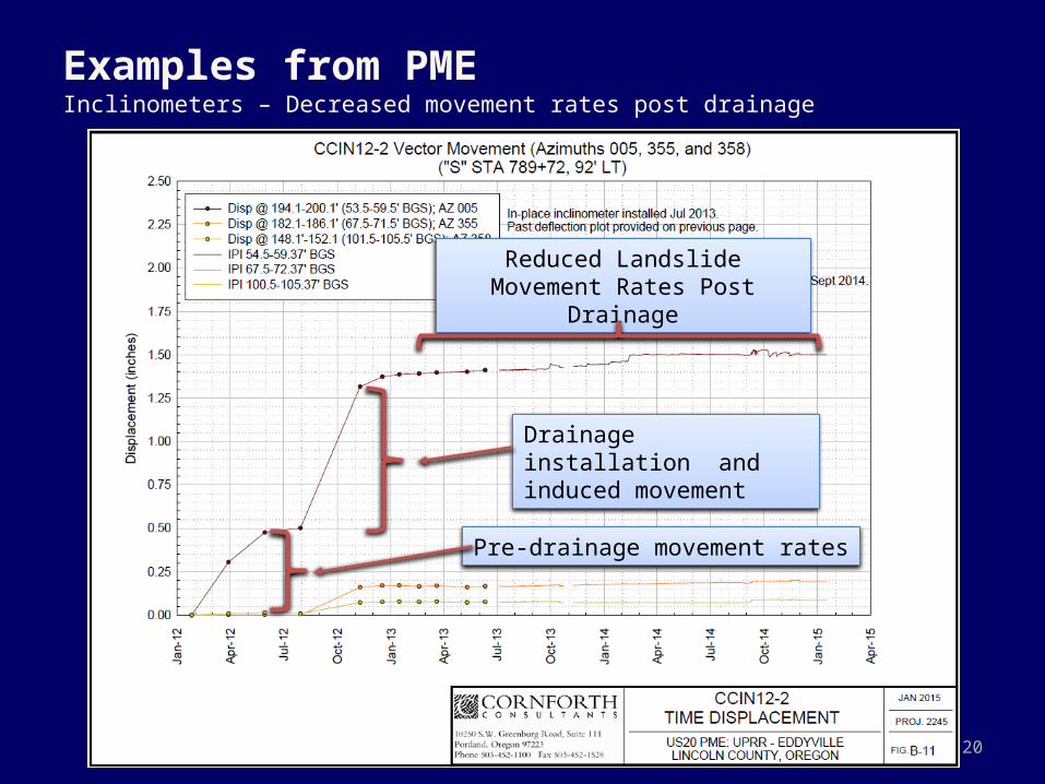
Examples from PMEInclinometers – Decreased movement rates post drainage
Pre-drainage movement rates
Drainage installation and induced movement
Reduced Landslide Movement Rates Post Drainage

21
Examples from PMEDrain Weir Monitoring – Groundwater Withdrawal after Storms

22
Examples from PMESettlement Monitoring – Test Fill Foundation Settlement

23
Examples from PMESettlement Monitoring – Culvert Foundation Settlement

24
Next up, the Observational Approach