Embed Size (px)
Citation preview
STATE OF ALASKA
DEPARTMENT OF NATURAL IPESOURCES
DIVISION OF GEOLOGICAL & GEOPHYSICAL SURVEYS
PN COOPERATION WITFI THE UNITED STATES
BUREAU OF MINES
Walter J. Hickel, Governor \
Harold C. Heinze, Commissioner
Thomas E. Smith, Llirector and State Geologist
December 199 1
Report of Investigations 91-4 ECONOMIC GEOLOGY OF HAINES-KLUKWAN- PORCUPINE M A , SOUTHEASTERN ALASKA
BY Jan C. Still, Robert B. Hockzema, Thomas K. Bundtzen, Wyatt G. Gilbert, Kevin R. Weir, Laurel E. Burns, and
Steven E. Fechner
STATE OF ALASKA Department of Natural Resources
DIVISION OF GEOLOGICAL & GEOPHYSICAL SURVEYS
According to Alaska Statute 41, the Alaska Division of Geological and Geophysical Surveys is charged with conducting "geological and geophysical surveys to determine the potential of Alaskan land for production of metals, minerals, fuels, and geothermal resources; the locations and supplies of ground water and construction materials; the potential geologic havlrds to buildings, roads, bridges, and other installations and structures; and shall conduct such other surveys and investigations as will advance knowledge of the geology of Alaska. "
In addition, the Division of Geological and Geophysical Surveys shall collect, record, evaluate, and distribute data on the quantity, quality, and location of underground, surface, and coastal water of the state; publish or have published data on the water of the state and require that the results and findings of surveys of water quality, quantity, and location be filed; require that water-well contractors file basic water and aquifer data, including but not limited to well location, estimated elevation, welldriller's logs, pumping tests, flow measurements, and water-quality determinations; accept and spend funds for the purposes of AS 41.08.017 and 41.08.035, and enter into agreements with individuals, public or private agencies, communities, private industry, and state and federal agencies; collect, record, evaluate, archive, and distribute data on seismic events and engineering geology of the state; and identify and inform public officials and industry about potential seismic hazards that might affect development in the state.
Administrative functions are performed under the direction of the State Geologist, who maintains his office in Fairbanks. The locations of DGGS offices are listed below:
.794 University Avenue ~ 4 0 0 Willoughby Avenue Suite 200 (3rd floor) Fairbanks, Alaska 99709-3645 Juneau, Alaska 99801 (907) 474-7147 (907) 465-2533
.Geologic Materials Center 18225 Fish Hatchery Road P.O. Box 772116 Eagle River, Alaska 99577 (907) 696-0070
This report, printed in Fairbanks, Alaska, is for sale by DGGS for $13. DGGS publications may be inspected at the following locations. Address mail order to the Fairbanks office.
Alaska Division of Geological & Geophysical Surveys 794 University Avenue, Suite 200
Fairbanks, Alaska 99709-3645
U.S. Geological Survey Earth Science Information Center Grace Hall, Alaska Pacific University Campus
4230 University Drive, Room 101 Anchorage, Alaska 99508-4664
CONTENTS
Page
.................................................................................................................. Abstract ............................................................................. ........................... Introduction ..
Physiography. climate. mid access .................. ., ............................................................... .............................................................................................................. L a d status
...................................................................................................... Acknowledgments Lode deposits, prospects, and occurrences of Porcupine area ...................................................
................................................................ Volcanic-associated massive-sulfide deposits ......................................................... ................................... Main deposit ..
Mount Henry Clay prospect ............................................................................. ................................................................................ Hanging Glacier prospect
.............................................................. ............................. Cap prospect .. .......................................................................................... Nunatak prospect
............................................................................ Little Jarvis Glacier prospect ............................................. Jarvis Glacier Gulches prospect :. ..........................
...................................................................................... Boundary occurrence Sunlrnit Creek zinc occurrences .........................................................................
....... .................................................. ...................... Iron Bridge prospect .. .. Other anomalous areas .................................................................................... Adjacent British Columbia prospects and deposits ................................................... Classification of volcanogenic massive-sulfide deposits in study area ............................
.............................................................................................. Vein gold prospects .................................................................................... Golden Eagle prospect
........................................... MclWey Creek Falls prospect ........................ ... .................................................................................... . Anuex No 1 prospect
........................................................................................ Wolf Den prospect ................................................................................... Quartz Swarm prospect
................................................................... Big Boulder Qwrtz ]Ledge prospect LeBlondeau vein occurrence .............................................................................
............................................................................. Polymetallic vein silver prospects ............................................................................... Lost Silver Ledge prospect
.................................................................................. Tsirku silver occurrence
.................................................................................. Merrill's silver prospect .. ................................................. ...................... Glacier Creek prospect ... ..
Skarn prospects and occurrences ............................. .. ............................................. ........................................................................... Claire Bear cobalt occurrence
Porcupine roof-pendant occurrence ..................................................................... ............................................................................ EeBlondeau skarn occurrence
Shannon prospect .......................................................................................... .................................................................................. Nataga Skyline prospect .................................................................................. Mount Seltat occurrence
Plutonic gold discri~ninant, Porcupine area .................................................................. Lode deposits, prospects, and occurrences of Haines-Klukwan area ...........................................
Previous work .................................................................................................... Klukwan mafic-ultramafic complex ...........................................................................
Gwlogy ..................................................................................................... ............................................................................... Klukwan lode iron deposit
...................................................................... Klukwan alluvial-fan iron deposit Inv~~tigations nt Klukwan for copper, gold, platinum, and palladium ............................
................................................................ Haines mafic-ultramafic complex occurrence ........................................ Disseminated copper occurrences ................... .... .. ....
36. Photograph showing diamond drilling the Road Cut prospect, 1987 ... . . . .. . . . . .. . . . .. .. . . .. . 37. Maps ahowing geophysical summaries for Road Cut prospect for 1986 and 1987.. . . . . . . . . . 38. Microphotograph of Sylvanite (Au, Ag, Ta) in chalcopyrite from the Road Cut prospect. 39. Road Cut prospect vertical cross section XS3, showing diamond drill-holes 1 and 3,
and surface-sample profile 17 .. . . . . .. . .. . . . . . . . . .. . .. . . . . .. . . . . . . . . . . . , . . . . . , . . . . . . . , , . , , . , . . . . . . . . 40. Map showing locations on Shikosi, Kataguni, and TaIsani Islands .. .. .. . ..... .. . .. . .. . . . . . . . . 41. Sketch map of abandoned channels on lower Porcupine Creek .. . .. . ... .. . .. ...... .. . .. . . . .. . . . 42. Diagram of stream gradients in the Porcupine area .. . . . . . . . . . . . . . . . . . . . . . . . . .. . . . . . . . . . .. . . . . . . . . 43. Photograph of placer sampling to evaluate placer deposits in the Porcupine area.. . . . . . . . . . . 44. Map showing placer sample locations, lower Porcupine Creek area .................... ,,.,,,, 45. Map showing placer sample locations, middle Porcupine Creek area.. .. . . .... .. . .. , ., , . . . . ,. , 46. Histogram of cumulative gold and gravel for varying sieve sizes for Porcupine Creek
samples B1-B4.. . . . . . . . . . . , . . . . . . . . . . . . . . . . . . . . . . . . . . . . . . . . . . . . . . . . . . . . . . . . . . . . . . . . . . . . . , . , . , , . . , . . , , , TABLES
Table 1. Scores for plutonic discriminant formations from the Haines-Klukwan-Porcupine- Skagway area . . . . . . . . . . . . . . . . . . . . .. . . .. . . . . . . . . . . . . . . . . . . . . , , . . . . , . . . . .\ . . . . . . . . . . . . . , . . . . . . . . . . . , .
2. Mineraldevelopment-potential ratings and identified resource estimates for drainages in the Porcupine area .. . . . . .. ... . ... . .. ... ... . .. .. , ..,. . .. . .. .. . . . . .. .... .. .. . . . .. . . . .. ..
3. Identified resources in bench and abandoned channel deposits in the lower and middle Porcupine Creek drainage . . . . . . . . . . . . . . . . . . . . . . . . . . . . . . . . . . . . . . . .. . . . . ., . , . , . . , . , . . . . , . . . .
SHEETS (in pocket)
Sheet 1. Lode deposits, prospects, and occurrences of Haines-Klukwan-Porcupine area 2. Land status in the Haines-Klukwan-Porcupine area 3. Klukwan lode and alluvial-fan deposits showing sample locations 4. Road Cut prospect showing geology, surface sample and diamond drill-hole
locations, and surface sample profiles 5. Quaternary geology s f the western part of the Porcupine Creek area showing
placer sample locations and figure outlines
ECONOMIC GEOLOGY OF HAINES-KLUIKWAN-PORCUPINE ARJ3A, SOUTHEASTERN ALASlKA
J.C. ~ti l1, l R.B. ~oekzema,~ T.K. ~ u n d t z e n , ~ W.G. Gilbert: K.R. weir,l L.E. ~ u r n s , ~ and S.E. ~ e c h n d
ABSTRACT
Placer gold wrls discovered in the Haines-Klukwan-Porcupine area in 1898 during the Klondike gold lush, and placer minitlg in the Porcupine Creek area has continued intermittently to the present. Silver was mined from veins in the Lost Silver Ledge prospect in the 1930s; the Klukwan-lode iron deposit was staked in 1946. Massive sulfide-barite deposits were discovered in the Glacier Creek area in the late 1960s.
The Porcupine area contains Kuroko-like volcanogenic massive-sulfide, vein gold, plymetallic vein silver, and skarn deposits, prospects, and occurrences. The Main deposit aIong Glecier Creek and the Mount Henry Clay prospect are the most important volcanogenic massive sulfide-barite showings. Samples from two barite- sulfide lenses in the Main deposit contain up to 9.98 ppm gold, 356 ppm silver, 7.8 percent zinc, 1.8 percent copper, '7.2 percent lead, and 56.5 percent barium. Most diamond-core drill holes into the Main deposit did not intersect the mineralized zone, and the downdip extension of the deposit remains unexplored.
Sphalerite-barite-pyrite-chalcopyrite-banded massive-sulfide boulders are found along the terminus of a glacier on the north side of Mount Henry Clay. The highest grade hulders contain 44 percent zinc and 5 percent copper. The grade of mineralization intersected by diamond-core drilling does not approach that found in the boulders.
Additional vol.canic-associated massive-sulfide showings in the Glacier Creek area inclucle the Hanging Glacier prospect, Cap prospect, Nunatak prospect, Little Jarvis Glacier prospect, Jarvis Glacier Gulches prospect, and the Boundary occurrence. Elevated values of zinc and barium were collected from slate and phyllite in the Summit Creek. drainage. Samples from the Iron Bridge prospect arid from an area south of Pyramid Harbor contain anomalous copper.
Seven gold-bearing vein prospects rind occurrences are known within the Porcupine area. Most of the occurrences are associated with "dike-ladder" veins cutting Late Paleozoic slate. The Golden Eagle p r o p t along McKinley Creek has produced modest amounts of gold. Other vein gold showings include the McKinley Creek Falls, Annex No. I., Wolf Den, Quartz Swarm, Big Boulder Quartz Ledge, and LeBlondeau Vein prospects and occurrences.
Three polyrnetallic vein silver showings crop out in the Tsirku River vdley near Summit Creek md Sunshine Mountain, Samples from the Lost Silver Ledge prospect, the Tsirku Silver occunmce, and Memll's Silver prospect contain anomalous values of silver, zinc, lead, gold, and copper.
Six minor skrun prospects and occurences are found within the Porcupine area along the contacts of Early Cretaceous plutons with calcareous horizons. Float and rubblecrop samples from the Mount Seltat occurrence contain up to 1.43 pprn silver, 4 percent zinc, 8,400 ppm copper, 2.6 percent lead, and 1,285 ppm tungsten.
The Haines-Klukwan area contains lode and alluvial-fan (placer) iron resources, disseminated copper occurrences, and numerous vein prospects and occurrences. The pyroxenite in the Klukwan ultramafic complex contains about 3.5 million tons of 16 percent iron ore; the Klukwan alluvial fan contains an inferred reserve of
'u.s. Bureau of Mines, Mayflower bland, P.O. Box 20550 Juneau, Alaska, 99802-0550 'u.s. Bureau of Mines, 3301 C Street, Suite 525, Anchorage, Alaska, 99503-3935 3AIaska Division of Geological & Geophysical Surveys, 794 University Avenue, Suite 200, Fairbanks, Alaska, 99709-3645
nearly 1 billion tons of 10 percent iron. The Haines mafic-ultramafic complex has billions of tons of iron resources, but they are scattered and of a low grade.
Minor di8semhbd copper occurences are exposed at the south end of Klutsha Mountain, on the ridge at the head of Goat Hollow, and on the west slope of Tukago Mountain. A high-grade sample collected from a small chalcopyrite-bornite lens at the Goat Hollow occurrence contained 15 ppm gold, 54 ppm silver, and 21.8 percent copper.
Four vein prospects are located along the west side of the Takshanuk Mountains between Klukwan and Haines. At the Mount Ripinski occurrence, quartz veins in metabasalt contained up to 12 ppm gold and 4 percent copper.
Most prospects and occurences in the Haines-Klukwan area are found within m e t a b d t of the Chillat Peninsula and Islands. At the Road Cut prospect, surface mineralization extends for 227 ft, but geophyics suggests that the mineralized zone may extend for 1700 ft. Mineralization was intercepted 25 ft below the surface in one diamond-core drill hole, and the indicated resources of the Road Cut Prospect are 700 tons at 0.09 odton gold, 0.17 odton silver, and 0.8 percent copper at a 3-ft width.
$
Additional metabasalt-hosted shear zone and dissemimated sulfide copper-zinc occurrences are found at the Road Cut I1 prospect and at the Zinc Beach, Battery Point, Shikosi Island, and Islands copper occurrences. Shear zones on the Chilkat Peninsula contain rock and stream-sediment samples anomalous in gold and copper.
Most Early Cretacaeous plutons in the northern part of the Porcupine area and plutons in the Haines- Klukwan area that are interpreted to be part of the Great Tonalite Sill Complex have geochemical characteristics that are associated with nonporphyry gold deposits.
The placer geology of the Porcupine area was affected by multiple Holocene glacial e p i d e s that left behind multiple drift limits, bedrock-incised bench channels, trimlines, hanging valleys, and beheaded drainages. Glaciofluvial processeg produced perched alluvial and colluvial fans and ice-marginal meltwater channels. The alluvial fan apex at the mouth of Porcupine Creek was probably once at least 1 mi south of its present position, and a distributary channel of this fan probably spilled over into the drainage now mupied by Walker lake. The Porcupine area, as a whole, is immature and nested in a high-energy fluvial environment.
Perched ice-marginal meltwater channels and modem Porcupine Creek sediments are the principal hosts of placer gold. The most important sources of placer gold in the Porcupine area are crosscutting quartz-sulfide-gold fissure veins associated with altered mafic dikes cutting Porcupine Slate. Gold fineness from the Porcupine are. averages 837. There are two types of gold present in heavy mineral concentrates: "nuggetn gold that shows evidence of fluvial transport, and wirelike grains that show little evidence of stteam transport. Fine gold is generally absent from Porcupine Creek and elevated channels, but could be preseat farther downstream in the Porcupine Creek alluvial fan.
Reconnaissance, channel, and site-specific sampling identified gravel deposits having moderate to high mineral development potential on lower Porcupine, Cahoon, Christmas, McKinley, and Nugget creeks. Abandonned channel and bench deposits on lower Porcupine Creek have the best potential for supporting a small to medium-sized heavy-equipment placer operation. The greatest potential for future mining on a large scale hinges on exploring the Porcupine and Nugget Creek alluvial fans, which together contain at least 8,000,000 yd3 of potentially auriferous gravel.
INTRODUCTION
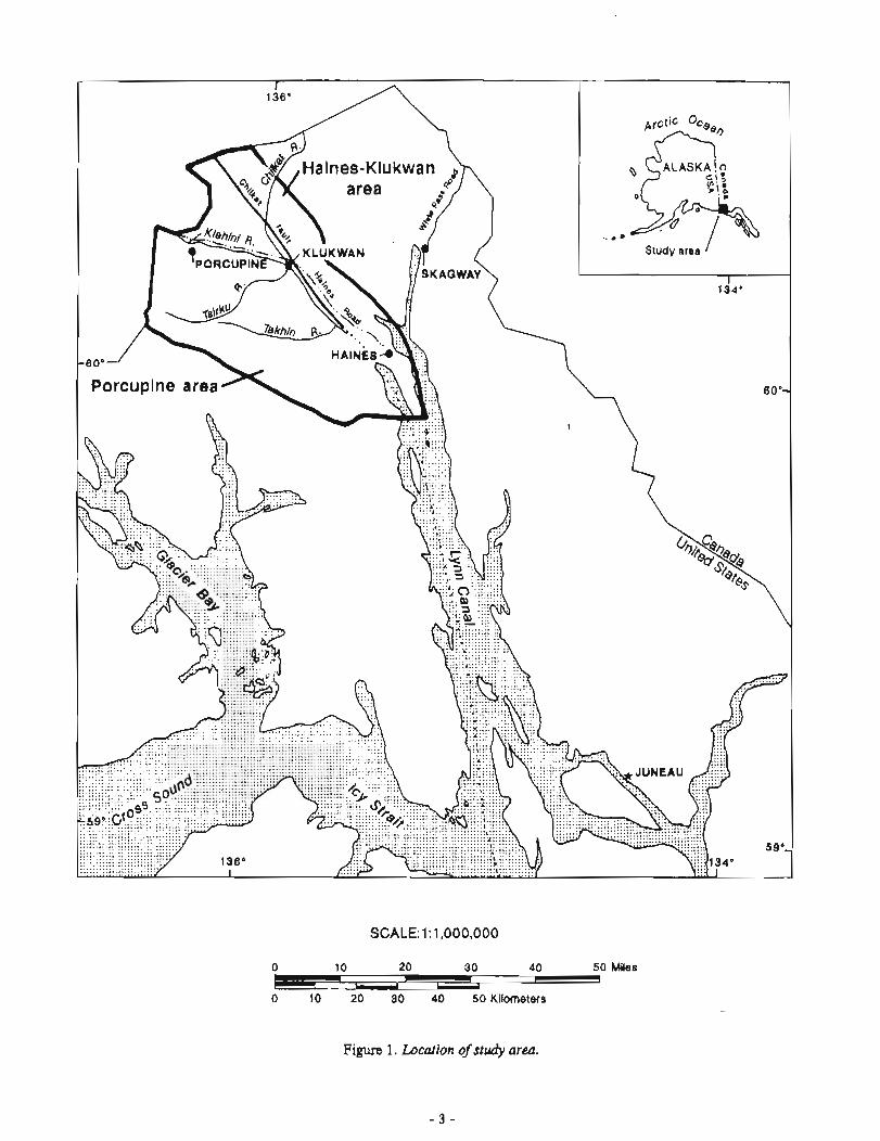
The Haines-Klukwan-Porcupine area is drained by the Chilkoot, Chillrat, and Tsirku river systems in the northern part of southeastern Alaska. The area is bounded on the north and west by the Alaska-British Columbia border, to the south by Glacier Bay National Park and Davidson Glacier, and to the east by the Chilkoot River valley and Lutak and Chilkoot inlets (fig. 1, sheet 1). This area was examined as part of a study of the Juneau
SCALE: 1 : 1,000,000
0 50 Miles
Figure 1, Location of study area.
mining district in a cooperative effort between the Alaska Division of Geological and Geophysical Surveys (DGGS) and the U.S. Bureau of Mines (USBM) ftom 1985 to 1988. In 1984, DGGS and the USBM cooperated in a study of the Glacier Creek-Porcupine Creek area; from 1981 to 1983 the agencies conducted separate studies in the area. Fieldwork was conducted by foot, boat, truck, and helicopter.
The bedrock geology in the area is subdivided into a western and eastern terrane as indicated by Gilbert and others (1991a). The area west of the Chillcat fault is called the Porcupine area and is discussed first; the area east of the Chilkat fault is called the ~aines-~lukwan-area (fig. 1). Earlier reports by the USBM and DGGS referred to the west-central part of the Porcupine area as the "Porcupine mining area. "
This report relies heavily on information on lode deposits, prospects, and c~ccurrenca previously reported by Still (1984a, 1984b, 1988) and Still and others (1985, 1987). Brew and others (1978) describe the mineral r e s o w of Glacier Bay National Park immediately south of the study area. The discussion of placer deposits of the Porcupine area is summarized from Bundtzen (1986) and Hoekzema and others (1986). Baggs and Shennan (1987) discuss the feasibility of mining various types of mineral deposits in the study area. The geologic framework of the area is d by Gilbert and others (1991a). Analytical data for most deposits and prospects are reported in appendixes A-H, but several minor occurrences refer to locality and gemhemica1 data presented in the companion report to this volume (Gilbert and others, 1991b). ,
PHYSIOGRAPHY, CLIMATE, AND ACCESS
The physiography of the area ranges from gentle to rugged. Glaciers formed the major features in the area and left U-shaped steep-walled valleys and rugged mountains. The Chilkat, Chilkoot, Klehini, Kelsall, Tsirku, and Takhin Rivers are the major drainages in the area. The higher mountains are glacier-clad, and some glaciers reach the valley floors. Lush forests and dense brush predominate up to timberline at about the 2,000-ft elevation. Elevation ranges from sea level (Haines) to 7,434 ft (Mount Henry Clay).
The average annual precipitation is 60 in. at Haines and is notably less at Klukwan and areas away from tidewater. Long winters with snowfall from October to April characterize the areas away from tidewater. The areas near tidewater have a somewhat milder climate.
The Haines-Klukwan-Porcupine area is serviced by an all-weather road that connects Haines and Klukwan with the Alaska Highway and the interior road systems of Alaska and Canada. Dirt roads connect the old partly abandoned town of Porcupine, the Kelsall River area, and the Chilkat Peninsula area with the Haines Highway. The Alaska Marine Highway System connects Haines with Bellingharn, Washington, and most coastal towns in southeastern Alaska. A small airport with a paved 4,500-ft runway at Haines services small aimaft.
LAND STATUS
The Haines-Klukwan-Porcupine area is made up of federal, state, and private land (sheet 2). State and private land occupies most of the Klehini, Chilkat River, and Chilkoot valleys. About one-third of the state land is part of the Chilkat Eagle Preserve and Chilkoot State Park, which are closed to mining; the rest is open to exploration and development under state law. The rest of the area is federal land, administered by the Bureau of Land Management and open to exploration and development under the Mining Law of 1872.
Most of the area lode claims are located between the British Columbia-Alaska border and Porcupine Creek; most of the study-area placer claims are located along Porcupine, Cahoon, McKinley, Nugget, and Cottonwood Creeks. The Klukwan area contains about 75 patented lode and placer claims.
ACKNOWLEDGMENTS
A special thanks goes to former Haines Bornugh Mayor Robert Henderson (1986-1987), to Haines City administrator Walter Wilcox, and to Pete Lapham, Haines maintenance supervisor for the Alaska Department of Transportation. All helped facilitate our studies. John Gammon of Falconbridge Limited, British Columbia,
allowed access to company claims on the Windy Craggy and Klukwan deposits. Doug Perkins of Stryker Re80urce-s Eunited, Brian Jones of Kennecott Exploration, and Earl Redman and Chuck Hawley of Chuck Hawley and Associates allowed access to company data and prospects. Local prospectors Merrill Palmer, Jim McLaughlin, Jo Jurgeleit, and R.C. Manuel all helped with this study. We are grateful to Mark Robinson for his very helpful review of this report, and we thank Nori Bowman for her extensive cartographic assistance.
LODE DE;POSITS, PROSPECTS, AND OCCURltl3NCES OF PORCUPINE AREA
Coastal Indian t& routes had long been in use in the Klehini ltiver valley by the time of the first recorded European exploration. G.M. Dawson in 1888, and J.B. Tyrrell in 1892, both members of the Geological Survey of Canada, explored the area ns part of a reconnaissance program pawson, 1888, Tyrrell, 1898). A.K. Brooks of the U.S. Geological Survey reported on the geology of the area in 1899 @rooks, 1900). Placer gold was found on Porcupine Creek in 1898 by prospectors en route to the Klondike gold fields. Shortly themfter, gold placers were tiiscovered along Glacier Creek and other creeks in the area. From 1898 to 1969 geologic mapping and proqxctuig in the vicinity centered on the Porcupine placer disttict. The first detailed geologic study of the Porcupine Creek area was made in 1903 by C.W. Wright (Wright, 1904). Eakins (1919) provided an excellent discussion of glaciation and placer-.-mining operations in the area. Numerous reference8 to the Porcupine Creek area are made in U.S. Geological Survey Wineral Resources of Alnska" and related series from 1 9 0 to about 1930 (Hoekzema and others, 1986).
k l y prospectors tried to find a lode source for the Porcupine placers, and during the early 1930% a local p r o p t o r di,~coveled the Lost Silver Ledge prospect near Summit Creek (Manuel, personal commun., 1983- 1985). In the early 1980s, Jim McLaughlin discovered the Golden Eagle lode prospect on McKinley Creek.
The first reports of massive sulfide-barite occurrences within the Porcupine area were made by prospector Merrill l'almer of Haines during 1969-1971 (Palmer, personal csrnmun., 1983-1988). From 1969 to 1971 E.M. MacKevett mapped the geology of the Skagway B-3 and B-4 Quadrangles and briefly examined the Glacier Creek barite-sulfide occumnm (MacKevett, 1971; MacKevett and others, 1974). In 1977 Holdsworth (1977) examined the Glacier Creek prospects discovered by Palmer (Holdsworth, 1977), as did Inspiration Development in 1979, and Anaconda Copper in 1980. Anaconda completed h.ee diamondcore drill holes, one of which intersected the Main deposit. In 1981 Coronado Mining mapped the Main deposit in detail (Peterson and others, 1982).
During 1983-1986 DGGS and USBM personnel mapped the geology of the Porcupine area, examined, mapped and sampled the lode and placer deposits, and conducted geochemical studies (Bundtzen and Clautice, 1986; Forbes, 1986; Gilbert and others, 1987, 1988; Gilbert, 1988; Hoekzema and others, 1986; R W and others, 1985; Still, 1984a, 1984b; Still and others, 1984, 1987). &mmt t Exploration shared with us their geological mapping of the Glacier Creek area (Rosenlrrans and Jones, 1985).
Eight volcanic-associated barite-sulfide prospects or occurrenca in the Glacier C& volcanics (&& 1, locs. 5-8, 10-13) are located 4 to 8 mi southwest of the Pleasant Camp border station on the Haines Highway. These deposih were discovered between 1969 and 1983 by local prospector Merrill P a l m (personal commun., 1983-1988) and first described and classified as probable volcanogenic syngenetics by Hawley (1976).
The Glacier Creek volcavlics consist maiuly of northwesterly striking schistose to massive metabasalt and metamorphosed basaltic andesite that locally show pillow structure. The unit includes subordinate black slate, felsic schist (metan~ff), rand marble. The Glacier Creek volcanics are partly Late Triassic and have undergone regional greenschist-fasies metamorphism (Gilbert and others, 19918). Mineralized zones hosted in these pocks are characterired by lenses of iron-stained quartz-sericite schist, cbloritic phyllite, tuff, and hydrothermally altered volcanic rocks. These l e w may be hundreds of feet thick and thousands of feet long. The quartz-sericite schist was probably derived from impure chert with a clay component (Fortea, 1986). Within the mineralized zone, stmtiform barite lenses extend parallel to bedding for up to 800 A and are up to 70 ft thick. These lensea contain
interspersed df ides that consist of varying amounts of sphalerite, pyrite, chalcopyrite, and galena. The volcanic rocks hosting the88 deposits were emplaced in an island arc, back-arc, or shelf environment, and are submarine exhalative, Kuroko-like volcanogenic massive-sulfide deposits (Forbes and Gilbert, 1989). Zinc-bearing slate also occurs in the Glacier Creek volcanics.
MAIN DEPOSIT
The Main deposit is exposed between 4,000 and 5,000 ft on the west side of Glacier Creek (sheet 1). The deposit was discovered in 1959, examined by U.S. Geological Survey in 1971 (MacKevett, 1971), and named by Mackevett and others (1974). The property has been optioned and examined by a number of mining companies, including Anaconda Copper, Kennecott Exploration, and Newmont Exploration. Both Anaconda and Newmont drilled this prospect. USBM work on this deposit consisted of mapping and sampling at selected locations along its 2,000-ft length and obtaining metallurgical test samples.
The Main deposit is within a section of hydrothermally altered metabasalt and metasdmentary rocks that lies within a thick sequence of basalt (fig. 2). In places, pillow structures were recognised in the basalt flows. The deposit strikes from about 3000 on the east to about east-west on the west and dips steeply northward. The Main deposit consists of two barite-sulfide lenses enveloped in orange-red-yellow stained phyllite and schist. The sulfides are predominantly sphalerite, but locally chalcopyrite, galena, or pyrite predominate. Magnetite was observed at some locations. Figure 3 shows sections through the deposit.
The westernmost lens averages 15 ft thick over a strike length of 250 ft; the easternmost lens averages 70 ft thick over a strike length of 800 ft. Samples contain up to 9.98 pprn gold, 356.5 ppm silver, 7.8 percent zinc, 1.8 percent copper, 7.2 percent lead, 56.5 percent barium, 4,000 pprn arsenic, 100 pprn nickel, and 2,000 pprn antimony (app. A-1). Based on an average of 15 composite samples collected by J.A. Robson and C.C. Hawley in 1974, these lenses average 60 percent barite, 1.73 percent zinc, and 60 pprn silver. Peterson and others (1982) estimate that the lenses contain about 0.75 million tons of mineralized rock if the lenses continue at depth for a distance of one-half their strike length and that 9 ft3 of ore weighs 1 ton.
A 3,000-lb bulk sample was collected from the Main deposit by owner ALYU Mining. It assayed 76.4 percent BaS04, 3.6 percent zinc, 0.98 percent copper, 0.12 percat lead, and 92 pprn silver. Peterson reports that several metallurgical testa were conducted by the Denver Equipment Division of Joy. The most successful involved grinding, flotation of sulfides, and conditioning of the barite (Peterson and others, 1982):
"Grinding of the ore to 200 mesh to meet size specifications for the barite product, flotation of the sulfides, followed by conditioning and flotation of the barite, provides a simple flowsheet which yielded recoveries sf 93 percent of the barium, 96 percent of the zinc, and 66 percent of the silver. Two stages of cleaner flotation produced a cleaned barite concentrate having a specific gravity of 4.4, and indications are that a single stage of cleaning would be adequate.
"On the basis that the bulk sulfide concentrate is marketable as produced, little work was done on separation of the various sulfide minerals. The bulk concentrate produced contained about 24 percent zinc, 5.5 percent copper, and 11.5 oz/ton of eilver as the principal values. The remainder of the concentrate is primarily pyrite which may carry a significant portion of the silver valuee. The zinc minerals present are highly activated for flotation due to the presence of copper salts, and indications are that any further separation of the sulfide minerals would be very difficult and would probably involve high losses in the copper and silver values."
The USBM collected two metallurgical test samples from the eastern barite-sulfide lens (3S118, 38258) and one from the western barite-sulfide lens (3S112). Head analysis for these three samples ranged from 43.4 to 56.5 percent barium, from 0.01 to Q.87 percent copper, from less than 0.01 to 4.64 percent zinc, from 0.08 percent to 4.98 percent lead, from 0.004 to 0.005 oz/ton gold, and from 0.36 to 1.02 odton silver (app. A-2).
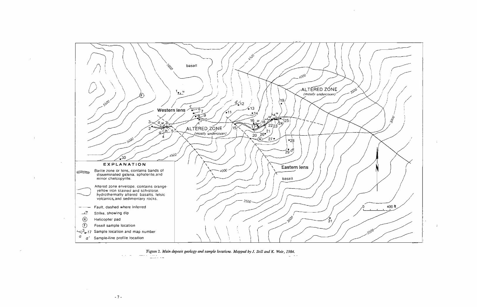
Figure 2. Main deposit geology and sampk locations. Mapped by J. Still and K. Weir, 1984. -- - .. -
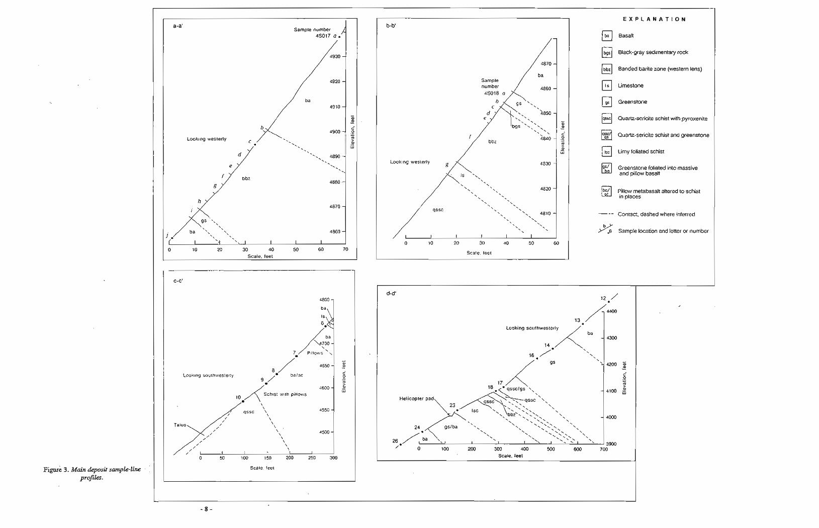
I?igu& 3. Main deposit sample-line profiles.
a-a' Sample number
.sol7 a .'
4910 - - a - c
4900 - 0 - m Looking westerly Q) - LLI
4880 -
4870 -
4860 - I
0 10 20 30 40 50 60 70
Scale, feet
-
b-b'
a, - w
Looking westerly 4830 -
4820 -
\ \ 4810 -
0 10 20 30 40 50 60
Scale, feet
E X P L A N A T I O N
Basalt
Black-gray sedimentary rock
@ Banded barite zone (western lens)
Limestone
Greenstone
Quarbsericite schist with pyroxenite
Quartz-sericite schist and greenstone
Limy foliated schist
Greenstone foliated into massive and pillow basalt
Pillow metabasalt altered to schist EJ in places
Contact, dashed where inferred
Sample location and letter or number
C-C'
4800 - ba
IS
Pillows \ \
-
m
4650 - 4 Looking southwesterly c
0 - 4600 - 2 w
4550 - \
Talus \ \ .
\ 4500 - \ \
/ \ \
I I I I
.O 50 100 150 200 250 300
Scale. feet
d-d' 12 /
Looking southwesterly
14200 5 - 17
4100 Helicopter pad
\
\ \ - 4000
\ \ '\ \',', \ \ \ gslba \ \ \ -. -. -.\ \
\
\ \ -. \ \ \
\
\ \ \ '--,'\',
\
\ \
\ , ' \ \
I 1 I \ 1 ,,- \, I ' ' 3900 0 100 2M) 300 400 500 600 700
Scale, feet
Samples were collected acroscl the mineralize$ zone at several locations (fig. 2). Samples of metabasalt, collected well out of the mineralized zone, contained significantly elevated zinc and lead values (figs. 2, 3; app. A-1).
The Main deposit is well exposed and its surface outcrops have been examined iu detail. However, most of the diamond-core holes were clrilled outside the mineralized zone, and the largest part of the downdip extension of the deposit remains unexplored.
MOUNT RENRY CLAY PROSPECT
The Mount Henry Clay prospect is located along the Alaska-British Columbia border on the rugged glacier- clad north aide of Mount Henry Clay, a b u t 5 mi southwest of the Pleasant Camp border station on the Haines Highway (sheet 1, fig. 4). The prospect was discovered in August 1983 by Merrill Palmer. A few days after Palmer's discovery, USBM personnel mapped and sampled the Mount Henry Clay prospect and collected metallurgical test sarnplcs (Still, 1984b). In 1984 and 1985 Kennecott Exploration optioned the Mount Henry Clay prospect, mapped the geology of the prospect, conducted geophysical surveys and drilled seven holes totaling 5,661 ft (Kosenkrans and Jones, 1985). Kennecott dropped its option on the property in 1986. In 1987 Newmont optioned the property but dropped it in 1988. Additional work on the prospect has not been reported.
A brief examination of the Canadian part of the deposit was made in 1983 (Still, 1984b). Duriag 1984, Stryker Resources and Freeport Resources (hereafter referred to aq Stryker) mappod and sampled the British Columbia part of the prospect in detail, discovering in-place barite-zinc mineralization and a train of barite- sphalerite boulders at the snout of a hanging glacier. In 1985, Stryker drilled five holes totaling 2,787 ft (Rosenkmm und Jones, 1985).
Massive-sulfide mineralization was not found in place on the U.S. part of the Mount Henry Clay p r o p t ; however, sphalerite-barite-pyritechalcopyrite-bmded massive-sulfide boulders, up to 6 ft thick, are found along the terminus of a small hanging glacier on the north side of Mount Henry Clay for a distance of 4,300 ft (fig. 4; app. A-3). Most sulfide-bearing boulders have rounded edges and appear to have been carried underneath the glacier to near their present location. The greatest abundance of massive-sulfide boulders was located between gullies 2 and 4 where the largest, highest-grade boulders were also found (figs. 4-7). Samples collected here indicated that most of the sulfide boulders between 1 and 6 ft thick contain from 20 to 44 percent xinc, about 5 percent barium, and several percent of copper. A 6-ft chip sample (figs. 6 , no. 27) across the largest boulder found assayed 33 percent zinc, 2.5 percent copper, 5 percent barium, 65 ppm silver, md a trace of gold. Sulfide boulders between gullies 1 and 2 and between gulliw 4 and 12 were mostly smaller, of a lower grade, and much less abundant (figs. 5-7). However, higher grade boulders were distributed throughout the hanging-glacier terminus area. Abundant massive-sulfide boulders were found at gully 12 and were generally higher in barium and lower in zinc than those found between gullies 2 and 4.
Most of the sulfide boulders are crudely banded from fractions of an inch up to 1 foot. The bands represent differences in sulfide or sulfate cotnposition from sphalerite to barite to pyrite to chalcopyrite to galena. The predominant ore mineral is sphalerite, with lesser amounts of barite, pyrite, chalcopyrite, and galena. Bornite was observed in polished sections. One boulder (fig. 6, no. 40) was found with attached host rocks of chlorite- epidote phyllite ( d t e d andesite). *She test of this boulder is silicified with chaicopyrite (the predominant sulfide) and lesser amounts of barite, pyrite, and sphalerite, Most of the sulfide boulders in the area have unoxidized surfaces and blend in with the greenish-gray andesite float.
Samples collected from bedrock exposures and stream sediments near the hanging-glacier terminus contain elevated values of zinc, silver, copper, lead, and barium (app. A-3). Bedrock samples collected from the east and west areas of the hanging glacier also contained elevated base-metal values. The west area contains a 4-ft-thick band of weak barite-zinc mineralization, whereas the east area contains quartz-barite veins (fig. 4, no. 46).
Kennecott Exploration drilled seven diamond-core drill holes (five of which were collared in the ice) and Stryker drilled five holes (figs. 8, 9). Correlating the geology of the diamonddrill holes (DDH) beneath the
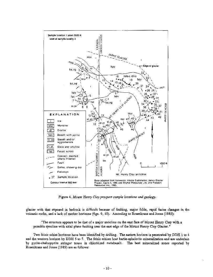
Figure 4. Mount Henry Clay prospect sample locutions and geobgy.
Sample locrtlon 1 lmken 2000 tl wen of sample locality 3 5 s -
Q ~ 1 2 IF 5 l k
. . --+Edge \ of glacier
\
Moraine
Diorite
[bpyl Basalt wi th pyrlte
[ba Basalt andlor agglomerate
Slate and phyl l l te
[ Felslc schist
-, Contact, dashed - where inferred
Fault 1000 ft Strike, showing dip
Fol iat ion Mt. Henry Clay anticline , 37 Sample location
glacier with that exposed in bedrock is difficult because of faulting, major folds, rapid facies changes in the volcanic rocks, and a lack of marker horizons (figs. 9, 10). According to Rosenkrans and Jones (1985):
CO~I~OU~ lntervrl 500 feet
"The structure appears to be that of a major anticline on the east face of Mount Henry Clay with a possible syncline with axial plane faulting near the east edge of the Mount Henry Clay Glacier."
Base adapted from Kennecott Alaska Exploration, J a w s Glacier Prolecl. figure 3. 1985 and Slryker Resources Ltd. and Freeporl Resources Inc.. 1985.
Two felsic schist horizons have been identified by drilling. The eastern horizon is penetrated by DDH 1 to 4 and the western horizon by DDH 5 to 7. The felsic schists host barite-sphalerite mineralization and are underlain by pyrite-chalcopyrite stringer zones in chloritized metabasalt. The best mineralized zones reported by Rosenkrans and Jones (1985) are as follows:
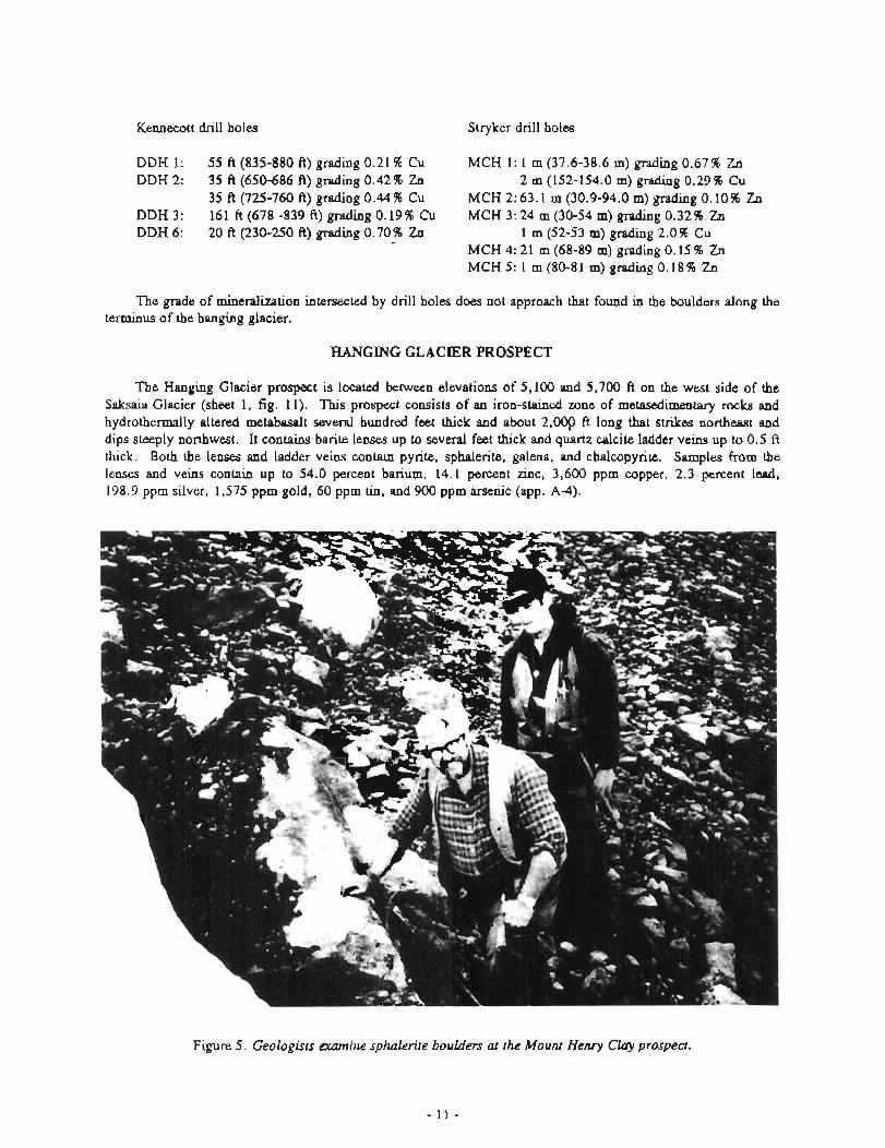
Kemecott drill holes Stryker drill holes
DDH 1: 55 A (835-880 A) grading 0.21 % Cu MCH 1: 1 m (37.6-38.6 m) grading 0.6796 Zn DDH 2: 35 ft (650-686 A) grading 0.42% Zn 2 m (152-154.0 m) grading 0.29 % Cu
35 ft (725-760 ft) grading 0.44% Cu MCH 2: 63.1 m (30.9-94.0 m) grading 0.10% Zn DDH 3: 161 ft (678 -839 ft) grading 0.19 96 Cu MCH 3: 24 m (30-54 m) g r a d ~ ~ ~ g 0.32 5% Zn DDH 6: 20 ft (230-250 ft) grading 0.70% Zn 1 m (52-53 m) grading 2.0 96 Cu -
MCH 4: 21 m (68-89 m) grading 0.15 % Zn MCH 5: 1 m (80-81 m) grading 0.18 96 Zn
The grade of mineralization intersected by drill holes does not approach that found in the boulders along the terminus of the hanging glacier.
HANGING GLACIER PROSPECT
The Hanging Glacier prospect is located between elevations of 5,100 and 5,700 ft on the west side of the Saksaia Glacier (sheet 1, fig. 11). This prospect consists of an iron-stained zone of metasedimentary rocks and hydrothermally altered metabasalt several hundred feet thick and about 2 . q ft long that strikes northeast and dips steeply northwest. It contains barite lenses up to several feet thick and quartz calcite ladder veins up to 0.5 ft thick. Both the lenses and ladder veins contain pyrite, sphalerite, galena, and chalcopyrite. Samples from the lenses and veins contain up to 54.0 percent barium, 14.1 percent zinc, 3,600 ppm copper, 2.3 percent lead, 198.9 ppm silver, 1,575 ppm gold, 60 ppm tin, and 900 ppm arsenic (app. Ad).
Figure 5. Geologists m i n e sphalerite bouIders at the Mount Henly Clay prospea.
- 11 -

--
Figure 6 . Eastem part of the Mount Henry Clay prosped showing high-grade zinc, silver, and barium sample locatiom and gully numbers.
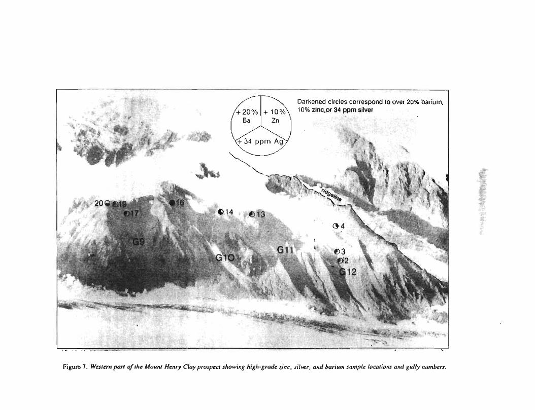
Figure 7. W a t m part of the Mount Henry Clay prospect showing high-gradc zinc, silwr, and barium sample locations and gully n u m b .
Figure 8. Kennecon Exploration diamond-core drill project on the Mount Henry Clay prospect.
CAP PROSPECT
The Cap prospect is located at an elevation of 3,800 ft on the west side of the Saksaia Glacier (sheet 1; figs. 11 12). It consists of an iron-stained zone about 50 ft thick and 220 ft long, capped by volcanics that crop out just above the Saksaia Glacier and whose extent is hidden by the glacier and cover. The iron-stained zone, which consists of mehwhentary rocks and hydrothermally altered metabasalt, has barite lenses up to 8 ft thick. Pyrite, sphalerite, galena, and tetrahedrite are found in the barite-rich horizon. Samples collected from this occurrence contained up to 55 percent barium, 1.1 percent zinc, 3,300 pprn lead, 227.7 pprn silver, 1.371 pprn gold, and 130 pprn cobalt (app. A-5). In 1988 Newmont explored and drilled the mineralized zone, but details of the drilling were not made available for this report.
NUNATAK PROSPECT
The Nunatak prospect is located between elevations of 3,800 to 4,500 ft on the east side of the Saksaia Glacier (sheet 1, fig. 11). The prospect consists of an iron-stained zone of quartz sericite schist and altered volcanic rocks exposed for 1,500 ft across the face of a nunatak. Within this zone, barite lenses and beds containing interbedded and remobilized sulfides crop out. Rubblecrop indicates that some of the barite-bearing beds may be up to 20 ft thick. Samples of the barite-rich rock contained up to 2.58 pprn gold, 335.3 pprn silver, 2.38 percent zinc, 1,820 pprn copper, 2.0 percent lead, 48 percent barium, and 1,000 pprn arsenic (app. A-6).
LITTLE JARVIS GLACIER PROSPECT
The Little Jarvis Glacier prospect is located along both sides of the Little Jarvis Glacier (sheet 1, fig. 13). The prospect consists of small discontinuous sulfide bands hosted in metasedimentary and metavolcanic rocks. Samples from the prospect contained up to 0.345 pprn gold, 11.8 pprn silver, 13.6 percent zinc, 1,900 pprn copper, 3.8 percent lead, 1.44 percent barium, and 2,000 pprn arsenic (app. A-7).
masslve zin
- , 4 Edge of glacier , \
/--
-- - Contacl dashed where 1 Inferred, dotted where ) u projected beneath Ice Conlour lntorvrl 500 fort - Fault
5- Strlke, show~ng d ~ p
antlcllne
I i i p e 9. Mount Henly Clay prospect geology, diamond-core drill hole and cross-section locationr.
JARWS GLACIER GULCHES PROSPECT
The Jarvis Glacier Gulches prospect is located on the south side of the Jarvis Glacier in a steep-walled m y o n about 4 mi east by southeast from the Pleasant Camp border station (sheet 1; fig. 14; app. A-8). Sulfide float found at the mouth of the canyon led to the discovery of some of the occurrences in August 1983 by USBM personnel. Other occurrences discovered in September 1983 by ALYU Mining consist of s m d showings of stratabound or stratifom sulfides such as sphalerite, pyrite, pyrrhotite, chalcopyrite, galena, and barite. Four occurrerlces have the best e x p o r n of mineralization (fig. 14, nos. 14, 17, 18, and 24). Most of the o c c w c e s are contained within a northwesterly striking volcanic-sedimentary unit of slate, limestone, and andesite, which is capped by meta-antiesite and metamorphosed pillow basalt.
Alternating bands of lixnestone, slate, and volcanic rocks are exposed for thousands of feet along the southwest side of the canyon. Some of the beds are prominently iron stained. Only a few locations were examined in this amyon, and the extent of sulfide mineralization may be much greater than that indicated by the
,..,' Contact dotted where projected
Kennecott drill holes
altered basalt
Stringer copper zone
Figure 10. Mount Henry Clay prospea moss sectionr.
small occurrences discussed below. The most interesting occurrence examined was located at an elevation of 3,600 ft on the southeast side of the canyon (fig. 14, no. 18) and consists of a zone of chlorite-altered metasedimentary rocks and meta-andesite containing lenses of massive- and disseminated sulfide mineralization. The zone follows bedding, is up to 5 ft across, and contains massive sulfide lenses up to 0.5 ft thick. It can be traced for at least 100 A. The sulfide lenses consist of pyrite, sphalerite, chalcopyrite, and galena in calcite- and quartz-rich rock. Samples collected from the zone contained up to 17.8 percent zinc, 230 pprn lead, 1.3 percent copper, 0.163 pprn gold, and 1 1.6 pprn silver. A 0.4-ft-thick quartz-& fide lens contained up to 5.4 percent zinc, 3,000 pprn lead, 160 pprn cobalt, 980 pprn copper, 0.416 pprn gold, and 25 pprn silver (fig. 14, no 17); and a 4- by 1 5 4 lens of iron-stained calcite, quartz, goethite, chlorite, pyrrhotite, and chalcopyrite assayed 790 pprn copper (fig. 14, no. 14).
Quartz stringer zones and sulfide zones occur on the north side of the canyon at an elevation of 3,200 ft, just above the canyon floor (fig. 14, no. 24). Sulfides occur in narrow lenses and disseminated zones, up to 9.5 ft thick, in meta-andesite. A chip sample across a 0.7-ft-thick rubble zone of barite, pyrrhotite, sphalerite, chalcopyrite, quartz, calcite, and chlorite assayed 5,600 pprn copper, 1.57 petcent zinc, 1.1 pprn silver, and 122 pprn cobalt. Other samples of sulfide zones taken at this locality contained up to 6.1 percent zinc, 7,600 pprn copper, 110 pprn cobalt, 0.127 pprn gold, and 4.6 pprn silver. The quartz stringer zones consist of veins up to 0.5 ft thick that contain sparse knots of pyrrhotite and chalcopyrite.
BOUNDARY OCCURRENCE
The Boundary occurrence is located about 1.75 mi south of Mount Henry Clay at elevations between 5,700 and 6,000 ft (sheet 1; also sheet 1, no. 132 and F54-F56 and sheet 2, nos. 185-186 of Gilbert and others, 1991b). It consists of narrow bands of iron-stained metasedimentary rocks and altered metabasalt that crop out
E X P L A N A T I O N
Ice
Colluv~al, alluv~aC and glacial deposlls und~fferenllaled
Altered zone (hydrothermal qulrh serlclte sch~st and altered basalt I
t3asall
Andeslte
Volcan~c and sedlrnentary rocks
Marble
_,- Conlact, dashed where' ,
covered with ice.
,-' Fault. dashed where Inferred
X Prospect
3 Sample location
1. Hang~ng Glac~er prospect
2. Cap prospect
3. Nunatak prospect
0 1500 tt (Id
Contour intrlvsl500 f w t
Figure 11. flanging Glacier, Cap, and Nunatakprospecis showing geology and Hanging Glacier and Nunatak simple locationr. Base mod1jIedji-om USGS Skagway B-4 l:Ci3,360 Quadrangle.
through glacial ice. A barite-rich band hosted in white phyllite contained 47 percent barium. Other samples collected from this p r o p t contained up to 960 pprn copper, 330 pprn cobr~lt, 400 pprn arsenic, and 200 pprn nickel.
!3UMMlT CREEK ZINC 0CCURRENGE;S
Zinc occurrences are located in the Summit Creek drainage (sheet 1). W o c k in the area consists predominantly of slate and phyllite, limy slate, and minor limestone. Strearrwdhent samples collected during 1985 at the nmuth of Summit Creek ant1 from small springs near the head of Summit Creek contained up to 0.020 ppm gold, 1.2 pprn silver, 1,620 pprn zinc, 1950 pprn barium, and 600 pprn bismuth (sheet 1, nos. 209-217 and F83-F90 of Gilbert and others, 1991b). In an attempt to locate the source of the metals in these highly anomalous mmples, bedrock and float samples were collected at scattered locations across the Summit
I Ice Barite bed or lens I Coliuvial, alluvial, and glacial Fault, showing direction of
deposits undifferentiated, horizontal movement over ly~ng bas'alt /
Strike, showing dip Quartz ser~ci te schist, with
ba r~ te lenses 75 Sample location and map .4 number
Andesite dike
Figure 12. Cap prospect geology and sample locations.
Creek drainage (sheet 2, nos. 385-402, 408-432, and 439-447 of Gilbert and others, 1991b). Quartzcalcite- sulfide float samples collected from talus slopes and moraine contained up to 0.686 ppm gold, 380.9 ppm silver, 2.5 percent zinc, 700 ppm copper, 4.1 percent lead, and 375 ppm percent barium. Bedrock slate samples contained up to 570 ppm zinc.
A stteam sediment sample collected below a spring surrounded by an iron-stained gossan contained 1.9 percent zinc. A sample of iron-stained calcitecemented slate scree, collected several hundred feet below the above sample and in the same stream contained 1.2 percent zinc. This calcite cement precipitated from the spring water and contains an unusual occurrence of sphalerite precipitated from groundwater.
IRON BRIDGE PROSPECT
The Iron Bridge prospect is located just northeast of the junction of Nataga Creek and the Kelsall River (sheet 1). During the 19708 a logging road was built across the Kelsall River and the area north and east of this bridge was logged. Mr. Jones, a local prospector, prospected the cuts in the newly built logging roads and discovered copper mineralization in metamorphosed volcanic and sedimentary rocks.
Figure 13. Little Jarvis Glacier prospen geology and sample locationr. Base madfledfrom USGS Skagway B-4 I:63,360 Quadrangle.
During 1988 we investigated the rvea roads, which are now thickly overgrown. Shallow trenches and stockpilea of malachite-stained silicified rocks were uncovered. One of three samples collected here contained up to 0.041 ppm gold, 5.6 pprn silver, and 2,960 ppm copper (sheet 2, no. 28 of Gilbert and others, 1991b).
OTHER ANOMALOUS AREAS
Numerous anomalous samples were collected in areas underlain by Paleozoic melavolcanic mks (Gilbert and others, 1991b). Of particular interat is the area about 3 km south of Pyramid Harbor, where thin layers of massive pyrrhotite anomalous in copper are found with Paleozoic exhalite in meta-andesite and metabasalt (Gilbert and others, 1991a, 1991b). A brief reconnaissance survey in the fall of 1989 suggests that a massive-sulfide prospect (Bull, 1991) along the west side of Lynn Canal 13 lun south of the study area is located near the top of a unit of metavolccmic and volcaniclastic rocks within the Kleheni metavolcanic belt (Gilbert and others 1991a, 1991b). Another anomdous area in unit Pzv includes the pyrrhotite-rich metavolcatlic rocks on the ridge 2 km
E X P L A N A T I O N
Ice
Coltuvlal. a l luv~al ,and g l a c ~ a l deposlts u n d ~ l l e r e n t ~ a l e d
Dlortte
Basalt
Andes~ te
Volcanic and sedimentary rocks
Volcanic and marble Contour interval 5W feet / /
Figure 14. Jarvis Glacier Gulches prospect geology and sample locations. Base malij?edfrom USGS Skagway B-4 1:63,360 Quadrangle.
west of Chilkat Lake. Finally, in the Herman Lake - Walker Lake - Sunshine Mountain area sparse outcrops of metabasalt in unit Pzvs are anomalous in copper (Gilbert and others, 1991b). Bedrock in this area is overlain by thin deposits of glacial drift; further prospecting is warranted.
ADJACENT BRITISH COLUMBIA PROSPECTS AND DEPOSITS
The Upper Triassic metavolcanic rocks that host the volcanic-associated massive-sulfide prospects in the Porcupine area extend north into British Columbia, where they crop out over a large area (fig. 15). These rocks trend to the area of the Windy Craggy deposit, where they are less metamorphosed than in the Porcupine area. The characteristics of the British Columbia deposits were briefly studied for a comparison to the deposits found in the Porcupine area.
Figure 15. Simplified geology of the area between the Porcupine area and Windy Craggy deposit showing prospect locations. Geology modified from Gilbert and others (1987). Campbell and Dobb (1979, 1983) and Macintyre (1983). Base modijiedfrom USGS Skagway 1:250,CWX)
The High Jarvis, Low Jarvis, High Herbert, Grizzly Heights, and Herbert Mouth prospects (fig. 15) are described by MacIntyre (1983) and Cambell and Dodds (1983). Most of these prospects are volcanic-associated massive-sulfide zinc-copper-barium-silver-gold prospects, hosted in felsic schists and altered volcanic rocks located within metabasalt believed to be equivalent to the Glacier Creek volcanics in Alaska.
The Windy Craggy and associated volcanic-associated massive-sulfide deposits (fig. 15) are hosted in metabasalt and thin mehsedimetary sequences. Between 1981 and December 1988, 78 holes totaling 87,000 ft were drilled, and 9,000 ft of drift and adit were driven at the deposit. The most recent geological estimates place Windy Craggy reserves at 114.3 million tons grading 1.92 percent copper, 0.08 percent cobalt, 0.006 odton gold, and 0.138 odton silver @owning and others, 1990). In 1982 a test sample was collecteh from Windy Craggy diamonddrill core and submitted for metallurgical testing (app. A-9).
CLASSPICATION OF VOLCANOGENIC MASSIVE-SULI;?DE DEPOSITS IN STUDY AREA
According to Dawson (1990), the Windy Craggy deposit shows some similarities to Cyprus-type massive- sulfide deposits; yet the alkaline-to-subalkaline composition of host volcanic rocks (Forbes, 1986; MacIntyre and Schroeter, 1986) and enclosing continental-clastic sediments are more characteristic of Beshi- or Kuroko-type mineralization (Fox, 1984). Lead isotopes from the Windy Craggy deposit plot in the Beshi field (Dawson, 1990). The proximity of massive barite and sulfides to an altered submarine vent led Hawley (1976) to suggest that the Glacier Creek deposit formed as Kuroko volcanic massive sulfides. Hence, we believe that the massive sulfide-barite deposits and occurrences in the Porcupine area could be classified as either Beshi- or Kuroko-type volcanogenic massive-sulfide deposits, depending on their proximity to volcanic vent systems.
VEIN GOLD PROSPECTS
Seven gold-bearing vein prospects and occurrences are known within the Porcupine area (sheet 1, nos. 4, 9, 15, 18, 20, 21, 26). Most of the occurrences are associated with "dike-ladder" quartz veins that cut slate. One, the Golden Eagle prospect, has gold values in the host slate. In British Columbia just north of the Porcupinie area near the west edge of the Jarvis Glacier, a fault-controlled quartz vein that extends for thousands of feet is hosted in diorite; it was extensively explored between 1915 and 1985 by shallow shafts, trenches, and diamond drilling.
GOLDEN EAGLE PROSPECT
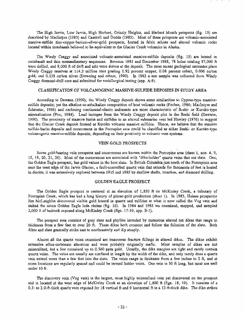
The Golden Eagle prospect is centered at an elevation of 1,850 ft on McKinley Creek, a tributary of Porcupine Creek, which has had a long history of placer-gold production (sheet 1). In 1983, Haines prospector Jim McLaughlin discovered visible gold hosted in quartz and sulfides at what is now called the Vug vein and staked the seven Golden Eagle lode claims (fig. 16). In 1984 and 1985 we examined, mapped, and sampled
, 2,000 ft of bedrock exposed along McKinley Creek (figs. 17-19, app. B-1).
The prospect area consists of gray slate and phyllite intruded by numerous altered tan dikes that range in thickness from a few feet to over 20 ft. These dikes both crosscut and follow the foliation of the slate. Both dikes and slate generally strike east to northeasterly and dip steeply.
Almost all the quartz veins examined are transverse fracture fillings in altered dikes. The dikes exhibit extensive silica-carbonate alteration and were probably originally mafic. Most samples of dikes are not mineralized, but a few contained up to 0.560 ppm gold. Usually, the dike margins are tight and rarely contain quartz veins. The veins are usually are confined in length by the width of the dike, and only rarely does a quartz vein extend more than a few feet into the slate. The veins range in thickness from a few inches to 2 ft, and at some locations are regularly spaced and could be termed ladder veins. One vein is 30 ft long, but most are well under 10 ft.
The discovery vein (Vug vein) is the largest, most highly mineralized vein yet discovered on the prospect and is located at the west edge of McKinley Creek at an elevation of 1,800 ft (figs. 18, 19). It consists of a 0.3- to 2.0-ft-thick quartz vein exposed for 18 vertical ft and 9 horizontal ft in a 12-ft-thick dike. The dike strikes
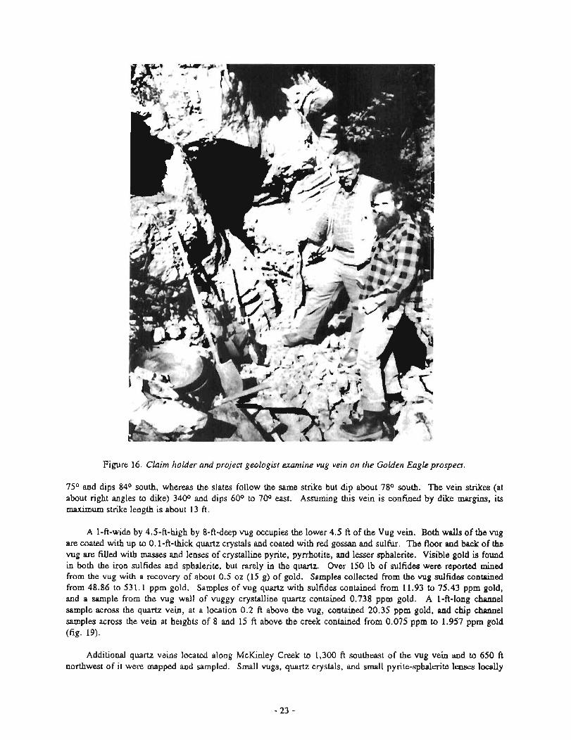
Figure 16. Claim holder and project geologist m i n e vug vein on the Golden Eagle prospect.
75O and dips 84O south, whereas the slates follow the same strike but dip about 78O south. The vein strikes (at about right angles to dike) 3400 and dips 600 to 70° east. Assuming this vein is confined by dike margins, its maximum strike length is about 13 fi.
A 1-ft-wide by 4.5-ft-high by 8-ftdeep vug occupies the lower 4.5 ft of the Vug vein. Both walls of the vug are coated with up to 0.1-ft-thick quartz crystals and coated with red gossan and sulfur. The floor and back of the vug are filled with masses and lenses of crystalline pyrite, pyrrhotite, and lesser sphalerite. Visible gold is found in both the iron sulfides and sphalerite, but rarely in the quartz. Over 150 lb of sulfides were reported mined from the vug with a recovery of about 0.5 oz (15 g) of gold. Samples collected from the vug sulfides contained from 48.86 to 53 1.1 pprn gold. Samples of vug quartz with sulfides contained from 11.93 to 75.43 pprn gold, and a sample from the vug wall of vuggy crystalline quartz contained 0.738 pprn gold. A 1-ft-long channel sample across the quartz vein, at a location 0.2 ft above the vug, contained 20.35 pprn gold, and chip channel samples across the vein at heights of 8 and 15 ft above the creek contained from 0.075 pprn to 1.957 pprn gold (fig. 19).
Additional quartz veins located along McKinley Creek to 1,300 ft southeast of the vug vein and to 650 ft northwest of it were mapped and sampled. Small vugs, quartz crystals, and small pyrite-sphalerite lenses locally
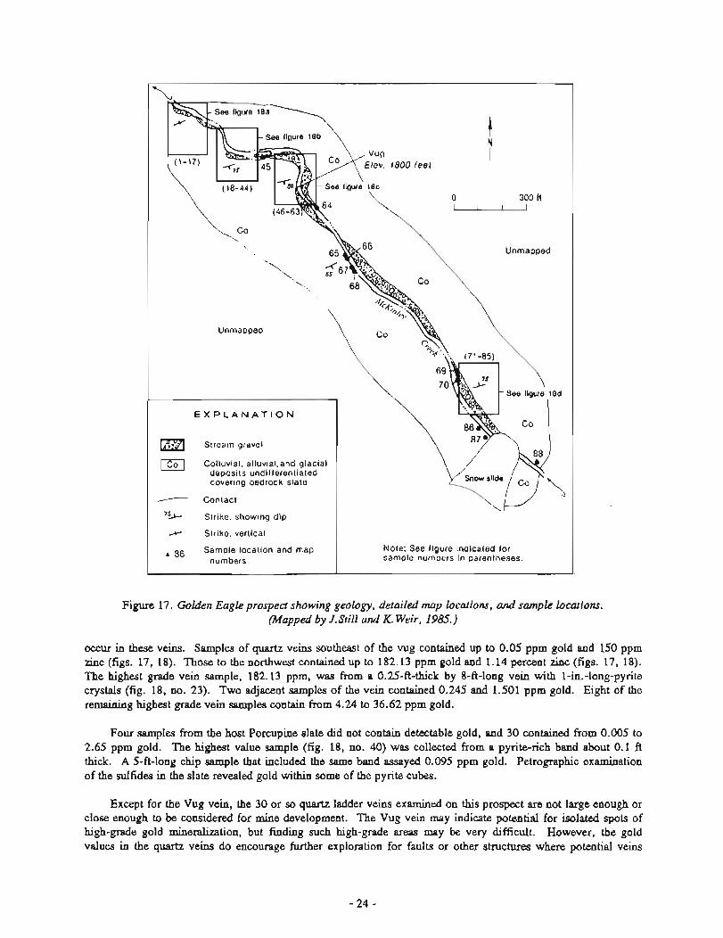
Figure 17. Golden Eagle prospect showing geology, hai led map locations, and sample locations. (Mapped by J.Still and K. Weir, 1985.)
Elev. 1800 feet
Stream gravel
Colluvial, alluvial,and glacial deposits undifferentiated covering bedrock slate
Contact
''A Strike, showing dip
x Strike, vertical . 86 Sample location and map Note: See figure indicated for
occur in these veins. Samples of quartz veins southeast of the vug contained up to 0.05 pprn gold and 150 pprn zinc (figs. 17, 18). Those to the northwest contained up to 182.13 pprn gold and 1.14 percent zinc (figs. 17, 18). The highest grade vein sample, 182.13 ppm, was from a 0.25-ft-thick by 8-ft-long vein with 1-in.-long-pyrite crystals (fig. 18, no. 23). Two adjacent samples of the vein contained 0.245 and 1.501 pprn gold. Eight of the remaining highest grade vein samples contain from 4.24 to 36.62 pprn gold.
numbers
Four samples from the host Porcupine slate did not contain detectable gold, and 30 contained from 0.005 to 2.65 pprn gold. The highest value sample (fig. 18, no. 40) was collected from a pyriterich band about 0.1 ft thick. A 5-ft-long chip sample that included the same band assayed 0.095 pprn gold. Petrographic examination of the sulfides in the slate revealed gold within some of the pyrite cubes.
sample numbers in parentheses.
Except for the Vug vein, the 30 or so quartz ladder veins examined on this prospect are not large enough or close enough to be considered for mine development. The Vug vein may indicate potential for isolated spots of high-grade gold mineralization, but finding such high-grade areas may be very difficult. However, the gold values in the quartz veins do encourage further exploration for faults or other structures where potential veins
Unmapped
Unmapped I
I Mapped by J. Stlll and K. Welr. 1985
Figure 18b
E X P L A N A T I O N I Stream gravel I
I Collwial, alluvial, and glacial deposits undifferentiated
I, Altered tan dike
Slate and phyllite
Quartz vein, only most prominent shown
Contact
Fault, showning dip
Sample locations and map numbers
I Figure 18. Golden Eagle prospect showing derailed
geology and sample locations (ad).
. . . . . , .: . ) . . .
E X P L A N A T I O N
Quartz vein
( Altered tan dike
Contact
"aJ.5~~ Sample locations
Figure 19. Golden Eagle prospect showing the vug geology and sample detail.
could be large enough to attract serious interest. The gold values in the slate suggest a possibility of low-grade, large-volume gold mineralization.
MCKINLEY CREEK FALLS PROSPECT
A gold-zinc prospect near the base of a falls in the steep-walled canyon containing McKinley Creek was examined (sheet 1). The area consists of slate with interbedded limestone that is cut by altered tan dikes. Narrow discontinuous quartz, sphalerite veins, or silicified bands were found hosted in the dikes, and to a lesser extent, in the slate and limestone.
Selected high-grade samples of quartz-sphalerite veins, hosted in dikes, contained up to 13.4 percent zinc and 8.959 ppm gold, and a 2.5-ft-long chip sample across a limy silicified band hosted in limy slate contained 24.83 ppm gold and 280 ppm zinc (sheet 1, no. 143, and sheet 2, no. 307 in Gilbert and others, 1991b).
ANNEX NO. 1 PROSPECT
The Annex No. 1 prospect, located on the cliffs above the west side of Porcupine Creek, was discovered by Jerry Fabrizio, a local prospector, in 1983 (sheet 1). The prospect consists of pyrite-bearing quartz veins associated with tan to gray altered dikes, exposed in a narrow gulch.
Samples of narrow, discontinuous pyrite-bearing quartz veins in the margins of dikes and in slate contained from 0.2 to 114.140 pprn gold (fig. 20). Samples of dike and slate contained from 0.005 pprn to 0.315 pprn gold. Selected high-grade samples aIso contained up to 9 pprn silver, 840 pprn zinc, 100 pprn tin, and 0.8 percent arsenic (app. B-2).
Colluvial, alluvial and glacial ------ contact deposits undifferentiated
[Isl Limestone x Strike, vertical I Slate and phyllite 5 Sample location I Figure 20. Annex No. 1 prospect showing geology atld sample locations. Base modz~edfrom USGS Skagway B-4
1:63,360 Quadrangle.
WOLF DEN PROSPECT
The Wolf Den prospect, located on the north slopes of Flower Mountain, was discovered and staked by Merrill Palmer in 1987 (sheet 1, fig. 21). It consists of quartz-pyrite-atsenopyrite-sphalerite veins hosted in a tan dike less than 10 ft thick. The veins are up to 0.3 ft thick and extend up to 5 ft, and are confined to the dike. Samples from the veins contained up to 11.417 pprn gold and 3,500 pprn zinc. A 5-ft-long chip sample of slate with pyrite bands collected upstream from the dike contained 0.103 pprn gold and 225 pprn zinc; a sample collected from quartz-sphalerite-galena-pyrite vein float contained more than 2 percent zinc, 0.171 pprn gold, and 645 pprn lead (app. B-3).
Sample 6 taken In creek, 0 4 R u 30ft below
(appro.uirnate) Sketch looking easterly I E X P L A N A T I O N I
Colluvial, alluviai,and glacial deposits undifferentiated
0 Altered tan dike
Slate and phyllite
Quartz vein I Contact I
--- 4 Sample location and map number.
Figure 21. WolfDen prospect showing geology and sample locatio?as. Sketch by J. ,Still and K. Weir (1987).
QUARTZ SWARM PROSPECT
The Quartz Swarm prospect is located on a mountain surrounded by glaciers that feed the headwaters of Porcupine Creek (sheet 1). It was discovered in 1984 by Palmer. It consists of quartz-vein swarms hosted in slate and metabasalt exposed in a prominent cliff exposure from 3,600 to 5,400 ft (fig. 22). These veins average about 0.5 to 1.5 ft thick and extend for hundreds of feet along strike. The swarms of veins are many hundreds of feet across ancl extend for thousands of vertical feet (fig. 23).
Sixty samples were collected from the veins and surrounding wall rock at various locations and elevations (fig. 22). Six of these samples, mostly quartz veins, contained from 0.005 to 0.09 pprn gold. The 60 samples contained up tn 2.4 pprn silver, 390 pprn zinc, 150 pprn copper, 3,000 ppm barium, 700 ppm arsenic, 200 pprn nickel, and 3,000 pprn antimony (app. B-4). Although trace amounts of gold and favorable geochemistry were found in these quartz swarms, significant gold values were not found in samples collected through 1,500 ft of elevation and 4,000 ft across structure.
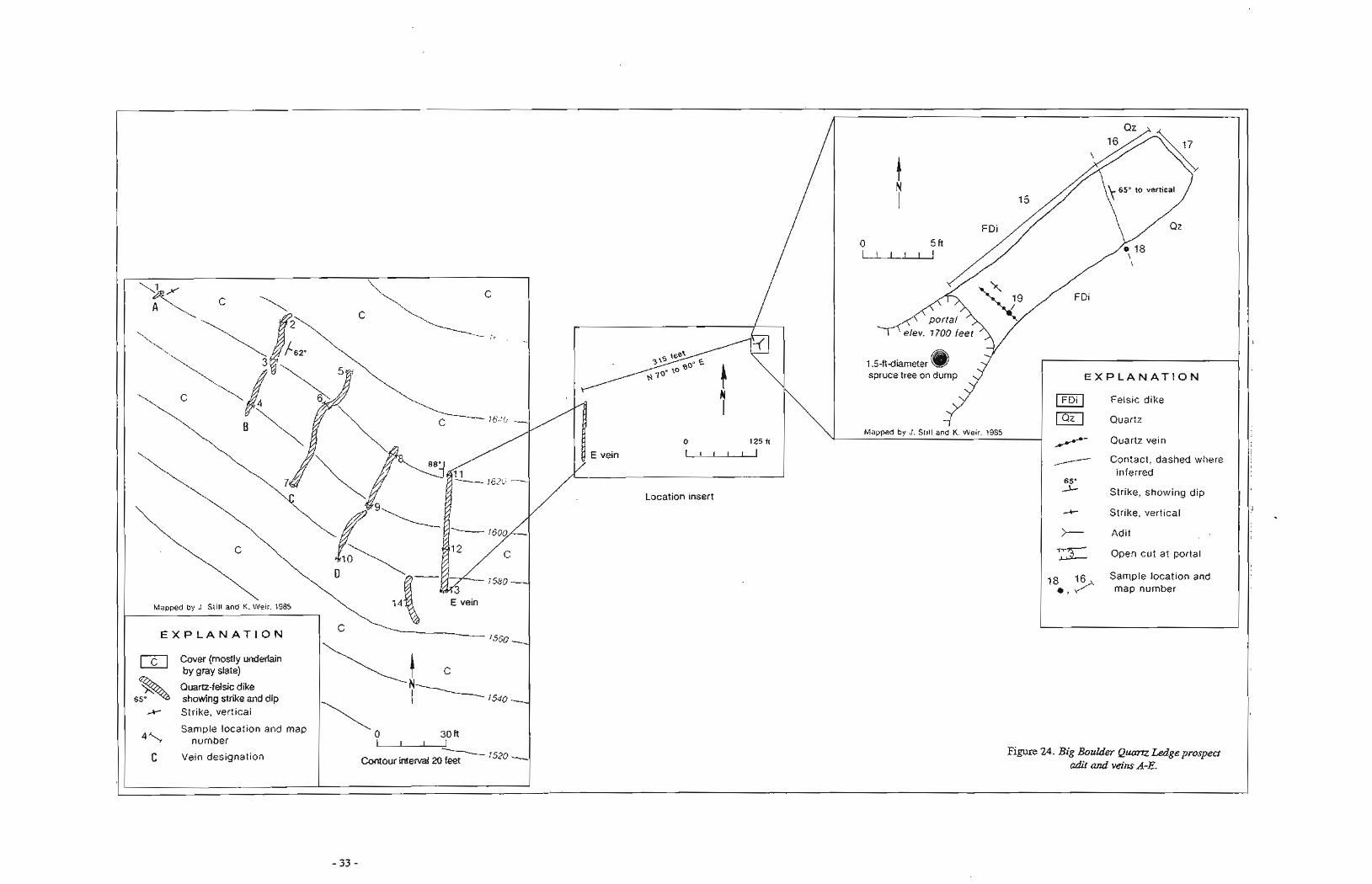
BIG BOULDER QUARTZ LEDGE PROSPECT
The Big Boulder Quartz Ledge prospect, located at an elevation of 1,500 ft east of Big Boulder Creek, colisists of a shallow adit and a series of felsic dikes in slate-bearing quartz segregations and veins (sheet 1). The quartz-bearing dikes strike north-northwest and have steep dips, are up to 1.3 ft thick, and crop out for up to 60 ft along strike. The adit was likely driven about 80 years ago, judging from a 1.5-ft-thick spruce tree growing on the dump near the adits portal. The adit was driven through a felsic dike for 18 ft and cuts a quartz band for
Figure 22. Quartz Swarm prospect showing geology and sample locations. Bare mod@edfrom USGS Skagway B-4, 1:63,3M Quadrangle.
about 5 f t (fig. 24). None of the 20 samples of quartz and dike rock contained anomalous gold, but they had up to 1.8 pprn silver, 308 pprn lead, 100 pprn tin, 500 pprn arsenic, 700 pprn bismuth, and 900 pprn antimony (~PP. B-5).
LEBLONDEAU VEIN OCCURRENCE
The LeBlondeau vein occurrence is located on the south side of the Tsirku River near the 4-mi-long retreating LeBlondeau Glacier (sheet 1). The snout of this glacier is the site of some limited placer activity, including the staking of placer claims. A reconnaissance of the area revealed gold mineralized float near the glacier snout (sheet 1, no. F70-72 of Gilbert and others, 1991b), and followup examination revealed gold-bearing quartz veins in an area exposed within the last 2 years by the retreating glacier (sheet 2, no. 614-616 of Gilbert and others, 1991b). Irregular quartz veins up to 0.8 ft wide and 50 ft long contained pyrrhotite and were found near the face of the retreating glacier. The veins cut bedding and are hosted in dikes and metachert. Samples from the veins contain up to 1.561 pprn gold, 2.3 pprn silver, and 251 pprn cobalt.
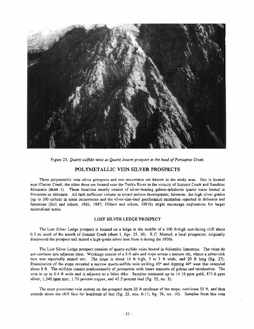
Figure 23. Quam-sulfide veins at Quam Swarm prospect at the head of Porcupine Creek
POLYMETALLIC VEIN SILVER PROSPECTS
Three polymetallic vein silver prospects and one occurrence are known in the study area. One is located near Glacier Creek; the other three are located near the Tsirku River in the vicinity of Summit Creek and Sunshine Mountain (sheet 1). These localities mostly consist of silver-bearing galena-sphalerite quartz veins hosted in limestone or dolomite. All lack sufficient volume to attract serious development; however, the high silver grades (up to 100 ozlton) in some occurrences and the silver-zinc-lead geochemical anomalies reported in dolomite and limestone (Still and others, 1985, 1987; Gilbert and others, 1991b) might encourage exploration for larger mineralized zones.
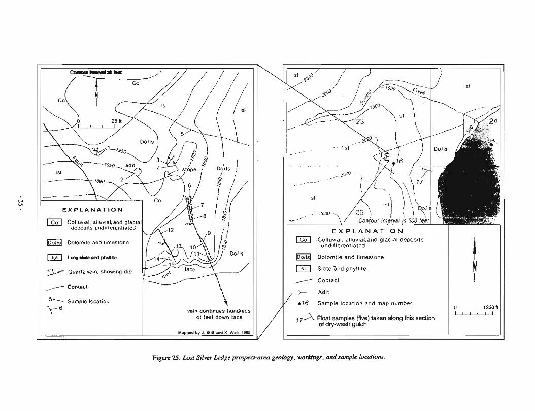
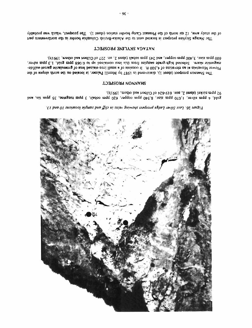
LOST SILVER LEDGE PROSPECT
The Lost Silver Ledge prospect is located on a ledge in the middle of a 500 ft-high east-facing cliff about 0.5 mi south of the mouth of Summit Creek (sheet 1, figs. 25, 26). R.C. Manuel, a local prospector, originally discovered the prospect and mined a high-grade silver lens from it during the 1930s.
The Lost Silver Ledge prospect consists of quartz-sulfide veins hosted in dolomitic limestone. The veins do not continue into adjacent slate. Workings consist of a 5-ft adit and stope across a narrow rib, where a silver-rich lens was reportedly mined out. The stope is about 10 ft high, 3 to 5 ft wide, and 20 ft long (fig. 27). Examination of the stope revealed a narrow quartz-sulfide vein striking 4S0 and dipping 40° west that extended about 8 ft. The sulfides consist predominantly of jamesonite with lesser amounts of galena and tetrahedrite. The vein is up to 0.4 ft wide and is adjacent to a felsic dike. Samples contained up to 14.19 ppm gold, 871.6 pprn silver, 1,540 ppm zinc, 1.70 percent copper, and 42.5 percent lead (fig. 25, no. 3).
The most prominent vein system on the prospect starts 25 ft southeast of the stope, continues 55 ft, and then extends down the cliff face for hundreds of feet (fig. 25, nos. 6-11; fig. 26, no. 10). Samples from this vein
system contained from 0.05 to 1.32 pprn gold, 346.0 to 3,423.1 pprn silver, 0.194 to 4.89 percent zinc, and 4.36 to 39.3 percent lead. Samples of quartz veins near the base of the dolomitic limestone cliff 500 ft below these workings (fig. 25, no. 16) contained up to 0.04 pprn gold, 8.9 pprn silver, 54.5 percent zinc, and 4,580 pprn lead (app. C-1).
TSIRKU SILVER OCCURRENCE
The Tsirku silver occurrence (sheet 1) is located on the east side of the Tsirku River at a location across from Summit Creek and the Lost Silver Ledge prospect. It was discovered by this study in 1986 and consists of scattered, narrow, and discontinuous silver-bearing zinc-galena quartz veins hosted in dolomite and limy slate. A representative chip sample across the highest grade vein contained 0.38 ppm gold, 653.5 pprn silver, 18.4 percent zinc, and 6.2 percent copper (sheet 1, nos. F80-F82, and sheet 2, nos. 497-502 in Gilbert and others, 1991b).
MERRILL'S SILVER PROSPECT
A silver prospect 1.5 to 2 mi southwest of VABM knob 1,720 (sheet 1) was first discovered by Palmer in 1980. It is in an area penetrated by overgrown logging roads, with few outcrops. It consists of narrow silver- bearing galena-sphalerite quartz veins scattered over a distance of at least 1,500 ft, between elevations of 700 to 950 ft (fig. 28). Sulfide vein mineralization is hosted in dolomite and argillite, and selected high-grade samples contained up to 0.471 pprn gold, 610.3 pprn silver, 13 percent zinc, 1640 ppm copper, and 15.7 percent lead (app. '2-2).
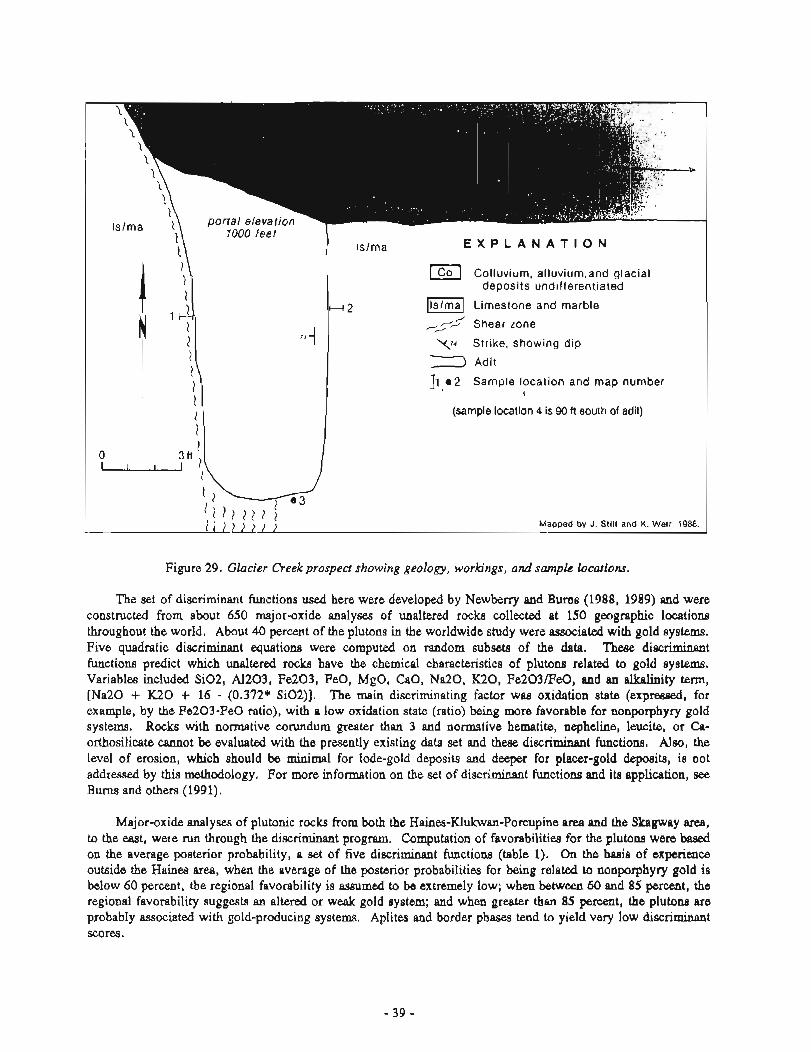
GLACIER CREEK PROSPECT
A 10-ft-long adit, driven along a pyrite-bearing shear zone in limestone, is located on the east bank of Glacier Creek (sheet 1, fig. 29) (MacKevett, 1971). Samples from the adit and its vicinity contained up to 0.59 pprn gold, 3 pprn silver, 1,100 pprn zinc, 550 ppm copper, and 140 ppm lead (app. C-3).
SKARN PROSPECTS AND OCC-CES
CLAIRE BEAR COBALT OCCURRENCE
The Claire Bear occurrence (sheet 1) is located east of Flower Mountain at an elevation of 3,700 ft in an area of considerable turf cover. It consists of narrow, discontinuous pyrrhotite-pyrite-chalcopyrite lenses in marble within the contact aureole of Early Cretacaeous quartz diorite - tonalite (fig. 30). Selected high-grade samples from these lenses or the rubblecrop below them contain up to 0.028 pprn gold, 56.2 pprn silver, 2,290 ppm copper, 1,070 pprn cobalt, 700 ppm tin, 1,000 pprn arsenic, 800 pprn nickel, 1,000 pprn bismuth, and 4,000 pprn antimony (app. D-1).
PORCUPINE ROOF-PENDANT OCCURRENCE
A 400- by 1,000-ft roof pendant surrounded by diorite is located at an elevation of 3,500 ft, near the headwaters of Porcupine Creek (sheet 1). A sample of gosmi rubblecrop collected 500 ft below the pendant contained 6.33 pprn gold, 18.2 pprn silver, and 515 ppm copper. The pendant consists of metamorphosed slate and limestone that form bands of garnet and diopside at some locations. Samples from the pendant contained up to 0.068 ppm gold, 1.1 ppm silver, 192 pprn zinc, and 230 pprn copper (sheet 1, no. F44 and sheet 2, nos. 340-345 of Gilbert and others, 1991b).
LEBLONDEAU SKARN 0C:CURRENCE
At elevations between 3,800 ft and 5,200 ft on the west wall of the LeBlondeau Glacier, a magnetite- chalcopyrite skarn crops out near a diorite-marble contact (sheet 1). This skarn is characterized by massive magnetite lenses up to 10 ft across with associated grossularite garnet, epidote, and marble. Chalcopyrite and pyrite are present hi small amounts. Selected high-grade samples from this skarn contained up to 0.068 pprn
51 Sample location
Y6 vein continues hundreds of feet down face
I I Mapped by J. Still and K. Weir. 1985
I i E X P L A N A T I O N I Colluvial, alluvial.and glacial deposits
undifferentiated
lao/lsl Do!omite and !irnes!one
(sl Slate s n d phyllite
A--- Contact
Adit
/ 016 Sample location and map number 0 1250 ft u 7X Float samples (five) taken along this section
of dry-wash gulch
Figure 25. Lust Silver Ledge prosped-area geology, workings, and sample locations.
'(91661 ' a q o pas ~raqpr3 JO LZZ 'on 'Z la*) t pqm mdd spz pns 'laddm mdd oot7'6 '3- mdd 009 ' i a ~ p mdd 6-1 '~108 mdd g g ~ - 0 01 dn p e q u m ma1 s q moy s a l h aparS-q%y paamlag -mcp qgau8wn -apgp-wmt qua-8 JO s q m s - u o i ! IPS t JO S I S ! ~ ~ 11 -y 00s '~ JO nogtAaIa w t t q r m o p ~ Jamold
a¶ JO d o l s wou a ~ 1 no pals301 er '1-d IIPJ~N 4 L861 m PJ~AWP '(1 mqs) t d o i d uomrer~s a u
'(91661 'aap)o pw FraqFf) Jo pZ9619 'SOU '2 w) laJ? mdd 26 Pns 'q mdd ~6 'wsarm) mdd 6 '~pqm mdd ozg 'laddm mdd ms'g '3- mdd 0 ~ 0 ' 1 ' 1 0 A p mdd p 'pp8
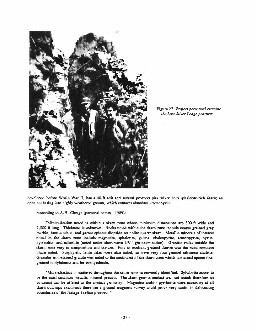
Figure 27. the Lost
personnel amn Silver Ledge prospect.
developed before World War II, has a 40-ft adit and several prospect pits driven into sphalerite-rich dcPm, an open cut is dug into highIy weathered gossan, which contains abundant arsenopyrite.
According to A.H. Clough (personal comm., 1989):
"Mineralization noted is within a skarn zone whose minimum dimensions ue 300-ft wide d 2,500-ft long. Thickness is unknown. Rocks noted within the skarn zone include coprse grained gray marble, biotite schist, and gametepidote-diopsideactinolitequartz skam. Metallic minerals of interest noted in the ekarn zone include magnetite, sphalerite, galena, chalcopyrite, amnopyrite, pyrite, pyrrhotite, and schmlite (noted under short-wave UV lightexamination). Granitic rocks outside the skarn zone vary in composition and texture. Fine to medium grained diorite was the most common phase noted. Porphyritic latite dikes were also noted, as were very fine grained siliceow alaskite. Granular iron-stained granite was noted to the southwest of the skarn zone wZlich contained sparse fine- grained molybdenite and femmolybdenite.
"Mineralization is scattered throughout the skam zone as currently identified. Sphalerite aeeme to be the most common metallic mineral present. The skam-granite contact was not noted; therefore no comment can be offered as the contact geometry. Magnetite and/or pyrrhotite were .ccessory at dl skarn outcrops examined; therefore a ground magnetic survey could prove very useful in delineating boundariee of the Nataga Skyline prospect. "
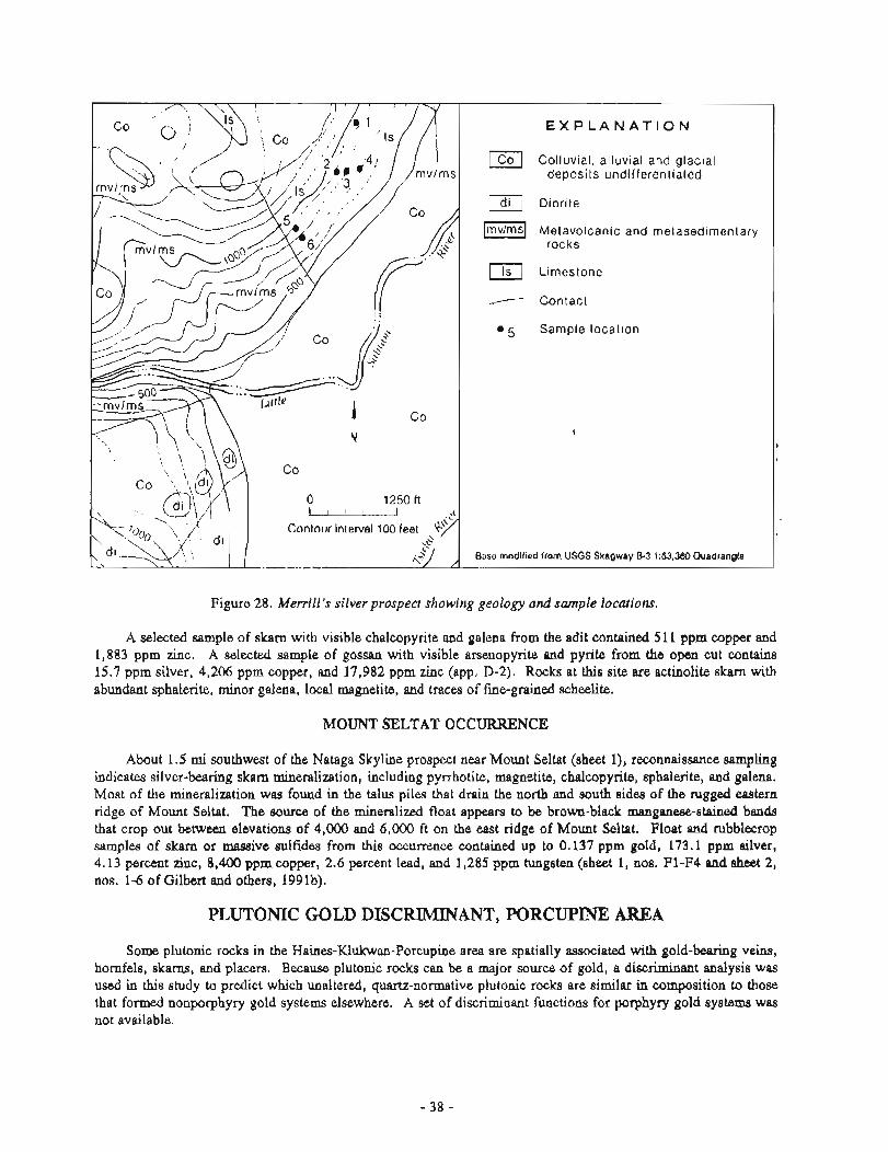
Figure 28. Merrill's silver prospect showing geology and s m p k locations.
A selected sample of skarn with visible chalcopyrite and galena from the adit contained 511 pprn copper and 1,883 ppm zinc. A selected sample of gossan with visible arsenopylite and pyrite from the open cut contains 15.7 pprn silver, 4,206 pprn copper, and 17,982 pprn zinc (app. 11-2). Rocks at this site are actinolite skarn with abundant sphalerite, minor galena, local magnetite, and traces of fine-grained scheelite.
MOUNT SXLTAT OCCURRENCE
About 1.5 mi southwest of the Nataga Skyline prospect near Mount Seltat (sheet I), reconnaissance sampling indicates silverbearing skam mineralization, including pyrrhotite, magnetite, chalcopyrite, sphalerite, and galena. Most of the mineralization was found in the talus piles that drain the rlo& and south sides of the rugged astern ridge of Mount Seltat. The source of the mineralized float appears to be brown-black mauganeee-stained bands that crop out between elevations of 4,000 and 6,000 ft on the east ridge of Mount Seltat. Float and rubblecrop samples of skarn or massive sulfides from this occurrence contained up to 0.139 pprn gold, 173.1 pprn silver, 4.13 percent zinc, 8,400 pprn copper, 2.6 percent lead, and 1,285 pprn tungsten (sheet 1, nos. F1-F4 and sheet 2, nos. 1-6 of Gilbert and others, 1991b).
PLUTONIC GOLD DISCRIMINANT, PORCUPINE AREA
Some plutonic rocks in the Haines-Klukwan-Porcupine area are spatially associated with gold-bearing veins, hornfels, skams, and placers. Because plutonic rocks can be a major source of gold, a discriminant analysis was used in this study to predict which unaltered, quartz-normative plutonic rocks are similar in composition to those that formed nonporphyry gold systems elsewhere. A set of discriminant functions for porphyry gold systems was not available.
Ea Colluvium, alluvium,and glacial deposits undifferentiated w] Limestone and marble
Shear zone 4 Strike, showing dip
) Adit
11 e2 Sample location and map number I
I I (sample location 4 is 90 ft south of adit) 1
L ( 2 1 ) 2 1 ) ; Mapped by J. Stil l and K. Weir, 1988. ---UL- --
Figure 29. Glacier Creek prospect showing geology, workings, and sample locationr.
The set of discriminant functions used here were developed by Newberry and Burns (1988, 1989) and were constructed from about 650 major-oxide analyses of unaltered rocla collected at 150 geographic locations throughout the world. A b u t 40 percent of the plutons in the worldwide study were associated with gold systerns. Five quadratic disc~imimnt equatio~ls were computed on random subset8 of the data. These discriminant functions predict which unaltered rocks have the chemical characteristics of plutons related to gold systems. Variables included Si02, A1203, Fe203, FeQ, MgO, CaO, Na20, K20, Fe203IFe0, and an alkalinity term, [Na20 f K 2 0 + 16 - (0.372* Si02)]. The main discriminating factor was oxidation state (expressed, for example, by the Fe203-Fe0 ratio), with a low oxidation state (ratio) being ]nore favorable for nonporphyry gold systems. Rocks with normative corundum greater than 3 and nonnative hematite, nepheline, leucite, or Ca- orthosilicate cannot b evaluated with the presently existing data set arid these discriminant functions. Also, the level of erosion, wbich should be d m 1 for lode-gold deposits and da:per for placer-gold deposits, is not addressed by this methodology. For more information on the set of discriminant functions and its application, see Bums and others (1991).
Major-oxide analyses of plutonic rocks from both the Haines-Klukwm-Porcupine area and the Skagway area, to the east, were run through the discriminaat program. Computation of favorabilities for the plutons were based on the average posterior probability, a set of five discriminant functions (table 1). On the basis of experience outside the Hainw area, when the average of the posterior probabilities for being related to nonporphyry gold is below 60 percent, the regional favorability is assumed to be extremely low; when between 60 and 85 percent, the regional favorability suggests an altered or we& gold system; and when greater than 85 percent, the plutons are probably associated with gold-producing systems. Aplites and border phases tend to yield very low discriminant scores.
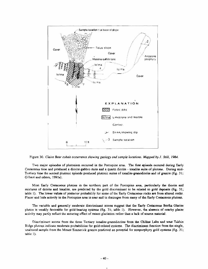
fl
tion 1 at base of slope
Cover
3 37W
I $
E X P L A N A T I O N 1
N Felsic dike
Limestone and marble
I ,,--- Contact
Strike,showing dip
1 1 3 Sample location 0 lo n u
Figure 30. Claire Bear cobalt occurrence showing geology and sample locations. Mapped by J. Still, 1984.
Two major episodes of plutonism occurred in the Porcupine area. The first episode occured during Early Cretaceous time and produced a diorite-gabbro suite and a quartz diorite - tonalite suite of plutws. During mid- Tertiary time the second plutonic episode produced plutonic suites of tonalite-granodiorite and of granite (fig. 3 1; Gilbert and others, 199 la).
Most Early Crchxoua plutws in the northern part of the Porcupine ueo, pnrticularly the diorite and mixtures of diorite and tonalite, are predicted by the gold discriminant to be related to gold dcpodts (fig. 31; table 1). The lower values of posterior probability for some of the Early Cretaceous rocks am from altered rocks. Placer and lode activity in the Porcupine area is near and in drainages from many of the Early Crebwmus plutons.
The variable and generally moderate discriminant scores suggest that the Early Cretaceous Bertha Glacier pluton is weakly favorable for gold-bearing systems (fig. 31; table 1). However, the absence of nearby placer activity may partly reflect the scouring effect of recent glaciation rather than a lack of source material.
Discriminant scores from the three Tertiary tonalite-granodioritea from the Chillrpt Lake and we& Takhin Ridge plutons indicate moderate probabilities for gold-related systems. The discriminant function from the single, unaltered sample from the Mount Emmerick granite predicted no potential for nonporphyry gold syetems (fig. 31; table 1).
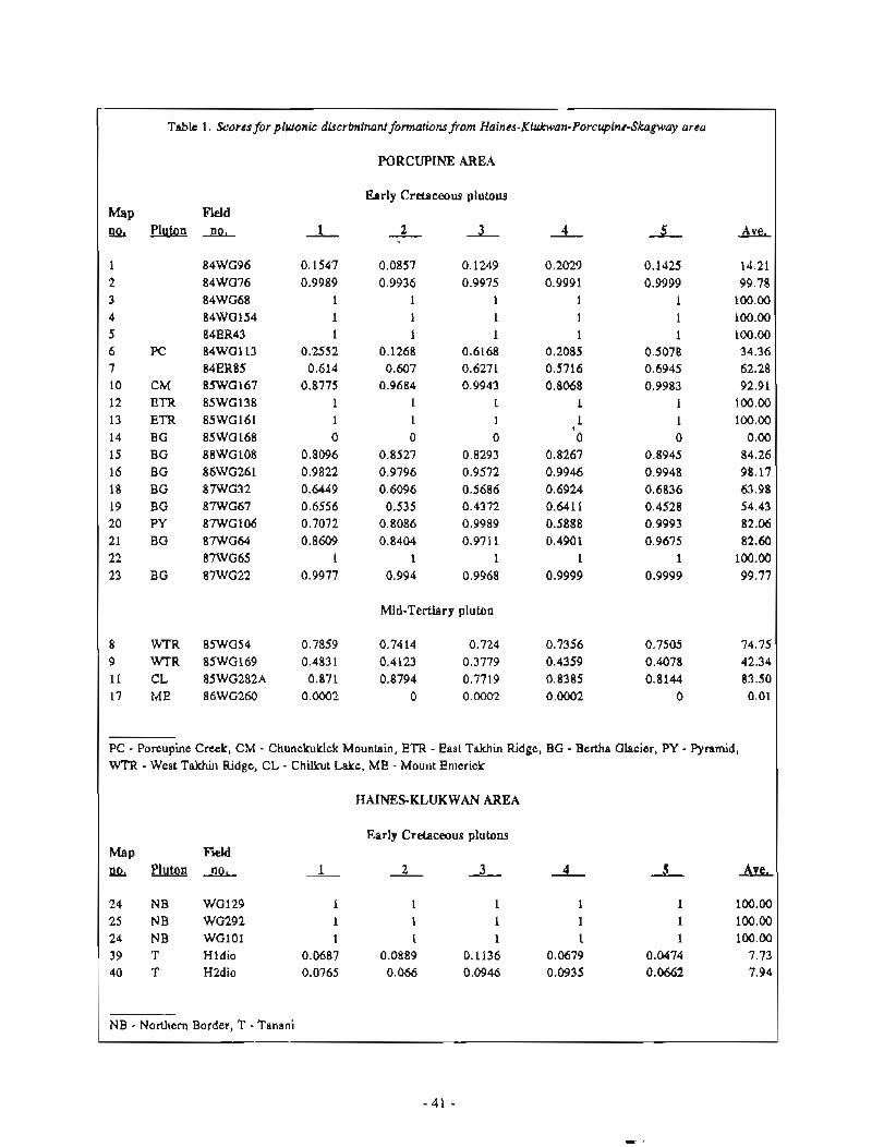
Table 1. Scores for plutonic dkcrbninanf formario~f~from Haines-Klukwan-Porcupine-Skagway area
PORCUPINE AREA I Early Cretaceous plutons
Mid-Tertiary pluton I 8 WTR 85WG54 0.7859 0.7414 0.724 0.7356 0.7505 74.75
9 WTR 85WG169 0.4831 8.4123 0.3779 0.4359 0.4078 42.34
11 CL 85WG282A 0.871 0.8794 0.7719 0.8385 0.8144 83.50
17 ME 86WG260 0.0002 0 0.0002 0.0002 0 0.01
- PC - Poi-cupinc Creek, CM - Chrlnckuklek Mountain, ETR - East Takhin Ridge, BG - Bertha Glacier, PY - Pyramid, I w?.a - West 'I'akhin Ridge, CL - Chilkut Lake, ME - Mount Emerick I
HAINESKLUKWAN AREA
Early Cretaceous plutons Fad
PIutoa n~ -- 1 - 2 - 3 - .L 4 Ave,
24 W B WG129 1 1 1 1 1 100.00 25 1VB WG292 1 1 1 1 1 180.00 24 NB WGlOl 1 1 1 1 1 100.00
h9 'r Hldio 0.0687 0.0889 0.1136 0.0649 0.0474 7.73
1 NB - Northern Border, T - Tanani
Table 1. Scorarforphonic discriminal~ fomwiomfrom Haines-Klukwan-Porcupine-Skagway area (conrinued)
Mid-Cretaceous plutons
M ~ P w P l u t o n n o . - 1 2 3 - 4 S Ave,
27 MK WG300 0.5234 0.0918 0.8293 0.0461 0.709 43.99 28 MK WG303 0.2394 0.0062 0.5994 0.0275 0.3713 24.88 29 MK WG302 0.4925 0.0274 0.7805 0.0084 0.6934 40.04 30 MK 87WG77 0.0138 0.0004 0.0611 0.0005 0.0044 1.60 31 MK K2dio 0.1653 0.0163 0.7872 0.0011 0.8633 36.66 32 MK w06_ 0 0 0 0 0 0.00 32 MK SHE16 (dup) 0.0008 0.0003 0.0026 0.0006 0.0008 0.10 33 MK w l l 0.0282 0.703 0.0939 0.4846 0.2185 17.91 33 MK SHE167 (dup) 0 0 0 0 0 0.00 34 MK w10- 0 0 0.0001 0 0 0.00 35 MK 88WG116 0.5056 0.4101 0.4683 0.4321 0.4085 44.49 36 MK w1234R058 0.2109 0.3599 0.8069 0.1101 0.493 39.62 37 MK w1334R053 0.0021 0.0015 0.0088 0 . q l 0.0025 0.34 38 MK 89K3 0.9825 0.9143 1 0,0001 1 77.94
SKAGWAY AREA
Late Cretaceous-Early Tertiary plutons
41 FC wlSNE082 0.9991 0.9959 0.9975 0.999 0.9991 99.81 42 FC w2SNE150 1 1 1 I 1 100.00 43 FC w3SHE070 1 0.9998 0.9999 1 1 99.99 44 PC w4SNE048 0.9853 0.9786 0.9823 0.988 0.987 98.42 45 FC w5SHE007 0.9983 0.9948 0.996 0.9985 0.999 99.73 46 FC w7SHE06E 1 1 1 1 1 100.00 47 FC w8SHE177 0.9994 0.9975 0.9984 0.9996 0.9998 99.89 48 FC w9SHE126 0.9993 0.9971 0.9974 0.9993 0.9996 99.85 49 FC 88WG124 0 0 0 0 0 0.00 50 FC 86WG280/4 0.6924 0.6601 0.6949 67.06 51 FC 86WG271/3 0.9986 0.9987 0.998 0.9997 0.9998 99.90 52 CG 86JTK342 0.1 0.0368 0.1689 0.1229 0.0381 9.33
MK - Mount Kashagnak, PC - Ferebee Complex, CG - Clifton Granite
LODE DEPOSITS, PROSPECTS. AND OCCURRENCES OF HAINES-KLUKWAN AREA
PREVIOUS WORK
Parts of the mafic-ultramafic complex near Klukwan have been extensively investigated as an iron resource. In 1946, claims covering both the ultramafic (pyroxenite) lode and the alluvial fan were staked and Alaska Iron Mines was incorporated to develop the deposit. Development work proceeded from that date and by 1961 consisted of surface sampling and diamond drilling of the lode, pit sampling, and chum drilling of the placer, aeromagnetic and ground magnetic surveys, and surface mapping. In addition, a pilot mill was constructed and concentrates were produced for metallurgical testing. In 1948, the USBM collected samples of the deposit for metallurgical testing (Wells and Thome, 1953), and in 1953 and 1954, the U.S. Geological Survey examined and mapped the deposit (Robertson, 1956). In 1961, Columbia Iron Mining (U.S. Steel) leased the claims for 75 years, and in 1964 parts of the property were patented. The lease by Columbia Iron Mining reverted back to Alaska Iron Mines in the 1970s.
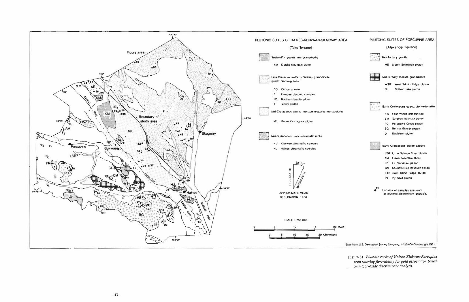
Figure 3 1. Pbonic rods of Haines-Khkwan-Porcupine area showing fmrability for gold association based
-- on major-oxide discriminant analysis.
Clark and Greenwood (1972) reported d t s of 10 samples collected at Klukwau that averaged 0.046 ppm platinum and O.aQOppm palladium, and Brobst and Pratt (1973) indicate 500 million tons of titaniferous magnetite that averages 0.092 ppm platinum-group metals.
In addition to thorough studies of the Klukwan complex, several reconnaissance studies of the geology and mineral-remurce potential of the Haines-Klukwan area have been completed. MacKevett and others (1974), Rednran and others (1985), Gilbert and others (1987, 5988) mapped geology and collected geochemical samples in the Hainw-Kiukwan area. Winkler and MacKevett (1970) report analyses from Id rock samples in the Chilkat Peninsula area, and Pla£ker and others discuss the geologic setting of the CBilkat Peninsula. Wells and others (1986) list prospects, occurrenceo, claim groups, and pertinent geochemical bedrwk and stream-sediment samples in the Chilkat Peninsula ma; they report samples from the the Battery Point goldcopper occurrence that contained I50 ppm chromium, 300 ppm copper, and "some" cobalt and nickel,
The IUukwan mafic-ultramafic complex is located 24 mi northwest of the city of Haines near the Native village of Klukwan (sheet 1). The ultramafic part of the complex has an exposed length and width of 3 by 1 mi along the 5,000-ft-high west side of the rugged Takshanuk Mountains. Below the ultramafic body ie an extensive alluvial fan partly mrde up of ultramafic float. The fan and ultramafic b d y have long been recognized as a significant iron deposit (sheet 3). The complex is tmsected by a series of deep canyons that form steep cliffs thowands of feet high and provide excellent rock exposures (fig. 32).
GEOLOGY
The Klukwan mafic-ultramfic complex lies within the Taku Terrae (Berg, 1978), which is bordered on the west by the Chatham Strait - Chilkat fault system and is part of the Klukwan-Duke belt of concentrically zoned mafic-ultmfic complexes of estimated middle Cretaceous age (Brew and Morrell, 1978). This belt extends the length of southeastern Alaska and includes numerous mafic-ultramafic intrusions.
The Klukwan mafic-ultramafic complex is surrounded by hornblende diorite, which is in contact with metabasalt to the west and quartz monzodiorite to the east (Gilbert anti others, 1991a). The hornblende diorite shows epidote alteration near the complex. Ultramafic magmas most likely intruded a warm diorite (Gilbert and others, 1991a).
Ultratramafic rocks at Klukwan consist of clinopyroxenite, hornblendite, and magnetite clinopyroxenite. Pegmatitic hornblende gabbro dikea are also p m n t . Sulfides are typically chalcopyrite, but pyrrhotite, pyrite, and bomite occur locally. The largest corlcentration of titaniferous magnetite occurs in the lower parts of the rnafic-ultmmafic complex.
KLUKWAN LODE IRON DEPOSlT
The lode part of the Klukwan iron deposit consists of vanadium-baring titanifemus magnetite hosted in pyroxenib. The magnetite occurs as massive bodies, irregular stringers, and coarsely and finely disseminated grains in the pyroxenite. The deposit has been diamond drilled and sampled extensively by Columbia Iron. The results of this work indicate that the entire pyroxenite Inass contains between 12 and 20 percent soluble iron, with rich, localized mnes of magnetite in the lower parts of the ultramafic of up to 50 percent iron. The pyroxalite mass constiturn about 3.5 million tons, if one assumes it extends downdip about 2 mi. The soluble-in1 content is r e p o d at 16.8 percent iron (Henry J . Kaiser Company, undated). The Ti% content averages 1.5 to 4.4 percent and the V205 content averages 0.2 percent, according to unpublished company analyses.
KLUKWAN ALLUVIAL-FAN IBON DEPOSIT
The Klukwan alluvial-fan iron deposit is located at the foot of the lode iron deposit and consists of float of diorite md magnetite pyroxenite that ranges in size from silt to 8-ft boulders. The fan extends for an approximate
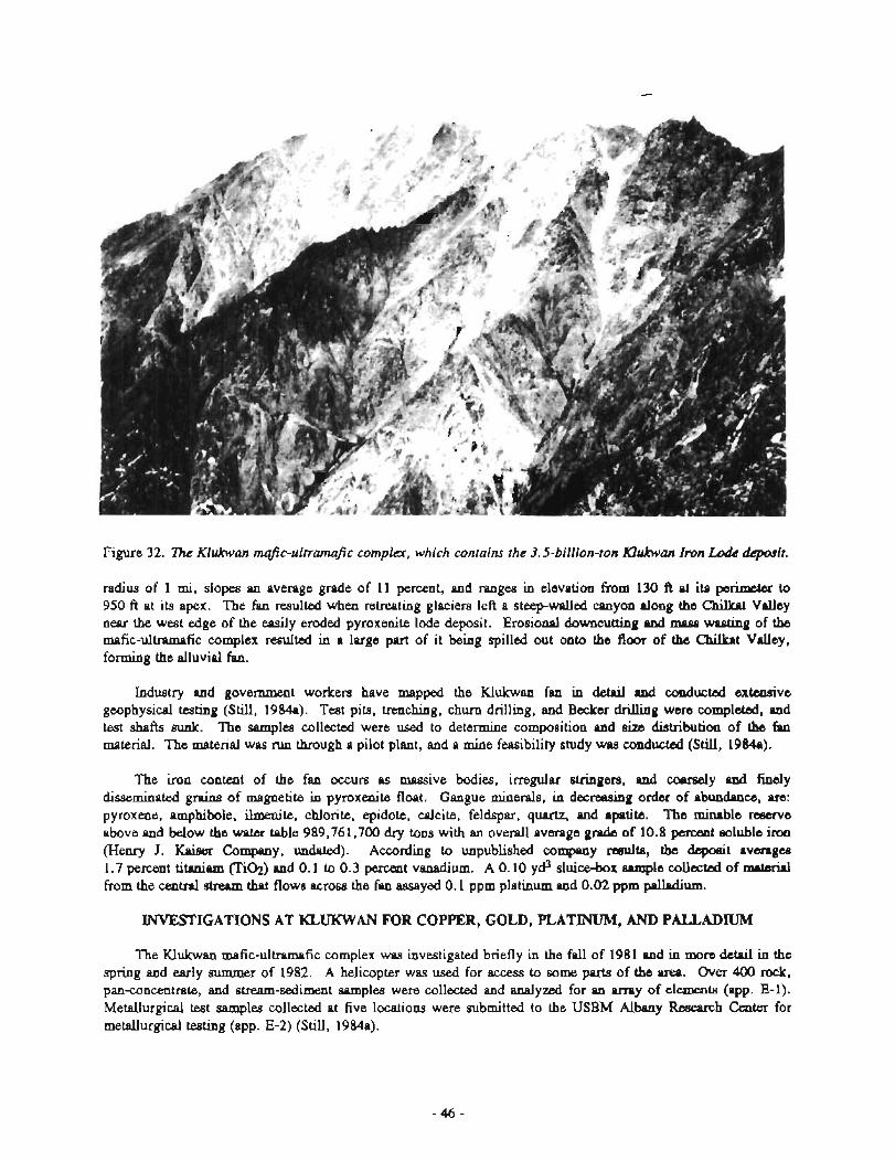
Figure 32. l?w Klukwan mafic-uhmjic complac, which contains the 3.5-billion-ton Klukwan Imn Lodc *it.
radius of 1 mi, slopes an average grade of 11 percent, and ranges in elevation from 130 ft at its perimbtsr to 950 ft at its apex. The fan rermlted when retreating glaciers left a steep-walled canyon dong the Chikat Valley near the west edge of the easily eroded pyroxenite lode deposit. Erosional downcutting and mpss wasting of the mafic-ultmmefic complex resulted in a large part of it being spilled out onto the floor of the Chikat Valley, forming the alluvial fan.
Industry and govenunent workers have mapped the Klukwan fan in detail and conducted extensive geophysical testing (Still, 1984a). Test pits, trenching, churn drilling, and Backer drilling were completed, and test shafts sunk. The samples collected were used to determine composition and size distribution of the fau material. The material was run through a pilot plant, and a mine feasibility study was conducted (Still, 1984a).
The iron content of the fan occurs as massive bodies, irregular stringers, and co~rsely nad fincly disseminated g r a i ~ of magnetite in pyroxenite float. Gangue minerals, in decreasing order of abundance, arc: pyroxene, amphibole, ilmenite, chlorite, epidote, calcite, feldspar, quartz, and apatite. The minable rwrerve above and below the water table 989,761,700 dry tons with an overall average grade of 10.8 pcmmt soluble iron (Henry J. Kaiser Company, undated). According to unpublished company results, the depoeit avsngce 1.7 percent titaniam (Tie) and 0.1 to 0.3 percent vanadium. A 0.10 yd3 sluice-box sample collected of mPterinl from the central stream that flows across the fan assayed 0.1 ppm platinum and 0.02 ppm palladium.
m I G A T I O N S AT KLUKWAN FOR COPPER, GOLD, PLATINUM, AND PALLADIUM
The Klukwan mafic-ultramafic complex was investigated briefly in the fall of 1981 and in more detail in the spring and early summer of 1982. A helicopter was used for access to some parts of the area. Over 400 rock, panconcentrate, and stream-sediment samples were collected and analyzed for an array of elements (app. E-1). Metallurgical test samples collected at five locations were submitted to the USBM Albany Research Center for metallurgical testing (app. E-2) (Still, 1984a).
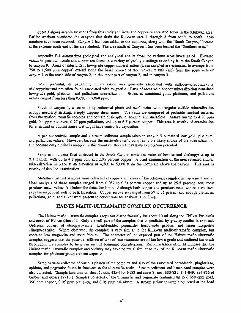
Sheet 3 h w s ample locatiom from this study and iron- and copper-mineralized zones in the Klukwan area. Earlier workers n u m b e d the canyons that drain the Klukwan area 1 through 8 from south to north; these numbera have been mtabied. Canyon 9 has been added to the sequence, along with the "South Canyon," located at the extreme, mu& d of the area studied. The area south of Canyon 1 hws been termed the "Southern area."
Appendix E-1 eummarizes geological and analytical results from the various areas investigated. Elevated values in precious d a and copper are found in a variety of geologic settings extending from the South &yon to canyon 9. Areas of intermittent low-grade copper mineralization (areas sampled are estimated to average from 750 to 1,500 pprn wpper) extend along the basal contact of the pyroxenite unit (Kp) from the south side of canyon 1 to tl~e north side of canyon 2, in the upper part of canyon 2, and in canyon 3.
Gold, platinum, or palladium minedization was generally associated with sulfides-predominantly chalcopyrite-and not often found associated with mngnetite. Parts of areas with copper mineralization contained low-grade gold, platinum, and palladium mineralization. Estimated combined gold, platinum, and palladium values ranged from leas than 0.030 to 0.068 ppm.
South of canyon 1, a m-k-s of hydrothermal pinch and swell veim with irregular sulfide mineralization occupy northerly striking, steeply dipping shear zones. The veins are compod of probable residual material from the mafic-ultramafic complex and contain chalcopyrite, bornite, and ~ d r c h i t e . Assays run up to 4.80 pprn gold, 0.1 ppm platinum, 0.27 ppm palladium, and up to 6.5 percent copper. 'Illis area is worthy of examination for structural or contact zones that might have controlled deposition.
A panconcentrate sample and a stream-sediment sample taken in canyon 9 contained low gold, platinum, and palladium values. However, because the rnafic-ultramafic complex is the likely source of the minedimtion, and because only diorite is mapped in this drainage, the area may have exploration potential.
Samples of diorite float collected in the South Canyon contained veins of bornite and chalcopyrite up to 0.1 ft thick, with up to 4.8 pprn gold and 2.95 percent copper. A brief examination of the area revealed similar mineralizatio~~ in place at an elevation of 4,500 to 5,000 ft on the mountain above the canyon. This m is worthy of detailed examination.
Metallu~rgical test samples were collected at copper-rich areas of the Kiukwan complex in canyo~ls 1 and 2. Head analysis of these samples ranged from 0.082 to 0.34 percent copper and up to 25.5 percent iron; most preciouq-mehl values fell below the detection limit. Although both copper and precious-metal contents are low, samples responded well to bulk floatation. Copper recoveries nmged from 57 to 76 percent and enough platinum, palladium, gold, atid silver were present to concentrate for analysis (app. E-2).
HAINES MAFIC-ULTBAMAFIC COMPLEX OCC-CE
The Haines mfic-ultramafic complex crops out discontinuously for about 10 mi along the C h i h t Peninsula and north of H b (sheet 1). Only a small part of the complex that is predicted by p i t y studies is exposed. Outcrops wmist of clinopyroxenite, homblendite, pegmalitic hornblende gabbro, and lesser magnetite clinopyroxdte. Where observed, the complex is very similar to the Klukwan mafic-ultramafic complex, but contains less rnagrletite and more biotite. The character of the exposed part of the HPinea mafic-ultramnfic complex suggests that the potential billions of tom of iron resources are of too low a grade and scattered too much throughout the complex to be given serious economic consideration. Reconnaissance samples indicate that the Kainea mafic-ultraxnafic complex axid vicinity may have potential sinrilar to that of the Klukwan mafic-ultramafic complex for platinum-group element deposits.
Samples were collected of various phases of the complex and also of the associated hornblende, ylagioclase, epidote, and pegmatite found in fractures in the ultramafic rocks. Stream-sediment and beach-sand samplea were also collected. (Sample locations on sheet 1, nos. 435-448, F133 arid sheet 2, nos. 830-831, 841-849, 854-856 of Gilbert and others 1991b.) Samples collected of the ultramafic and pegmatite contained up to 0.068 pprn gold, 790 ppm copper, 0.05 pprn platinum, and 0.05 pprn palladium. A stream-sediment sample collected at the head
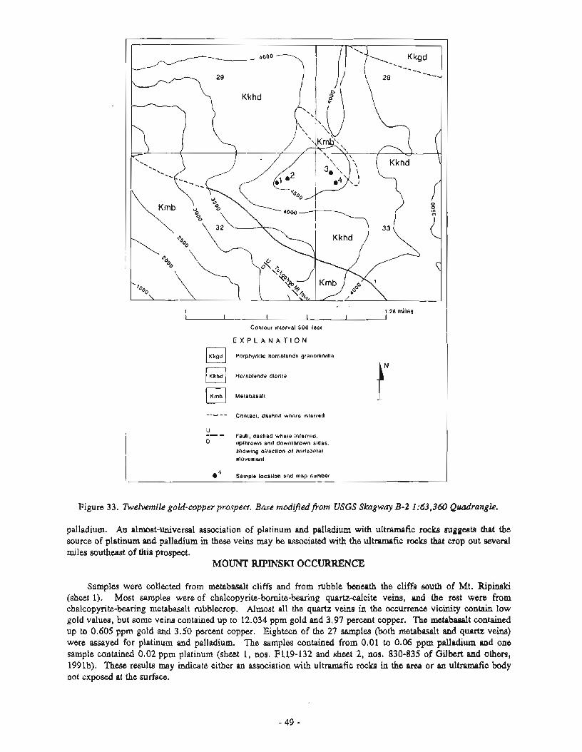
. . 1 1.25 r n ~ l e s L- I I
Contour ~nterval 500 leat
E X P L A N A T I O N
Porphyritic hornblende grano<liorite
Hornblende diorile
Metabasall
Contact, dashed where inlerred I U -- -
Fault, dashed where inferred. 0 upthrown and downthrown sides.
showing direction of horizontal movement
e4 Sample locallon and map number
Figure 33. lbelvemik gold-copper prospect. Base modifiedfiom USGS Skagway B-2 1:63,360 Quadrangle.
palladium. An alnmst-univercral association of platinum and pdladium with u l t m f i c rocke mggests that the source of platinum and palladium in these veins may be associated with the ultramafic rocks that crop out several miles southeavt of this prospect.
MOUNT 'RIPINSKI OCCWKENCIC
Samples were collected from m e t a b d t cliffs and from rubble h e a t h the cliffs south of Mt. Ripinski (sheet 1). Most samples were of chalcopydte-bomite-bearkg quartz-calcite veins, and the rest were from chalcopyrite-bearing metebasalt rubblecrop. Almost all the quartz veins in the o c c w w vicinity contain low gold values, but some veins contained up to 12.034 ppm gold and 3.97 percent copper. The metabsalt contained up to 0.605 ppm gold and 3.50 percent copper. Eighteen of the 27 samples (both metabasalt and quartz veins) were assayed for platinum and palladium. The samples contained from 0.01 to 0.06 ppm palladium and one sample contained 0.02 ppm platinum (sheet 1, nos. F119-132 and sheet 2, nos. 830-835 of Gilbert and others, 1991b). There results may indicate either an association with ultramafic rocks in the area or an ultramafic body not exposed at the surface.
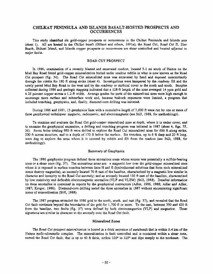
CHILKAT PENINSULA AND ISLANDS BASALT-HOSTED PROSPECTS AND OCCURRENCES
This study identified six goldapper prospects or occurrences in the Chilkat Peninsula and Islands area (sheet 1). All are hosted in the ChiIkat basalt (Gilbert and others, 1991a); the Road Cut, Road Cut II, Zinc Beach, Shikosi Island, and Islands copper prospects or occurrences are shear controlled and located adjacent to major faults.
ROAD CUT PROSPECT
In 1986, examination of a recently blasted and excavated roadcut, located 3.1 mi south of Haines on the Mud Bay Road found gold-copper mineralization buried under roadcut rubble in what is now known as the Road Cut prospect (fig. 34). The Road Cut mineralized zone was excavated by hand and exposed intermittently through the rubble for 180 ft along strike (sheet 4). Investigations were hampered by the roadway fill and the newly paved Mud Bay Road to the west and by the roadway or surficial cover to the north and south. Samples collected during 1986 and geologic mapping indicated that a 128-ft length of the zone averaged 14 ppm gold and 4.25 percent copper across a 1.2-ft width. Average grades for parts of the mineralized zone were high enough to encourage more surface and rmbrmrface work and, because bedrock exposures were limited, a program that included trenching, geophysics, and, finally, diamond-core drilling was initiated
During 1986 and 1987, 13 geophysics lines with a cumulative length of 7,600 ft were run by one or more of three geophysical techniques: magnetic, radiometric, and electromagnetic (see Still, 1988, for methodology).
To examine and evaluate the Road Cut goldcopper mineralized zone at depth, where it is under cover, and to examine the geophysical anomalies, a drilling and trenching program was initiated in 1987 (sheet 4, figs. 35, 36). Seven holes totaling 980 ft were drilled to explore the Road Cut mineralized zone for 600 ft along strike, 200 ft across structure, and to a depth of 170 ft below the surface. Six trenches, up to 6 A deep and 20 A long, were dug to explore the zone where it is covered by rubble and fill from the roadcut (see Still, 1988, for methodology).
Summary of Geophysics
The 1986 geophysics program defined three anomalous areas whose source was potentially a sulfide-bearing zone or a shear zone (fig. 37). The anomalous areas are: a magnetic low over the goldcopper mineralized zone where it is exposed in surface trenches between lines H and E (hydrothermal solutions that form such mineralized zones destroy magnetite); an anomaly located 70 ft east of the baseline, characterized by a magnetic low similar in character and intensity to the Road Cut anomaly; and an anomaly located 120 fi east of the baseline, characterized by low resistivity and definable electromagnetic anomalies (VLF and VLEM) (Still, 1988). Detailed information on these anomalies is contained in reports by the geophysical contractors (Adler, 1986, 1988; Adler and Adler, 1987; Kruger, 1986). Diamondcore drilling tested the three anomalies in 1987 without encountering significant zones of minetalization (Still, 1988).
The 1987 program extended the 1986 grid to the north, south, and east (fig. 37), and revealed that the Road Cut fault continue8 beyond the boundaries of the grid for 1,700 ft or more. To the east, between 350 and 420 ft from the baseline, two faults (fig. 37) were defined by both electromagnetics (VLF) and magnetics. These signatures are similar in character to the anomaly over the Road Cut fault.
Mineralized Zones
The Road Cut prospect mineralization is hosted in a thick sequence of metabasalt that is within 0.4 km of the Haines mafic-ultramafic complex. The mineralization is fault controlled and is contained within a shear zone, named the Road Cut fault, that is up to 40 ft thick, strikes 3200 to 32S0 and dips steeply to the northeast. The
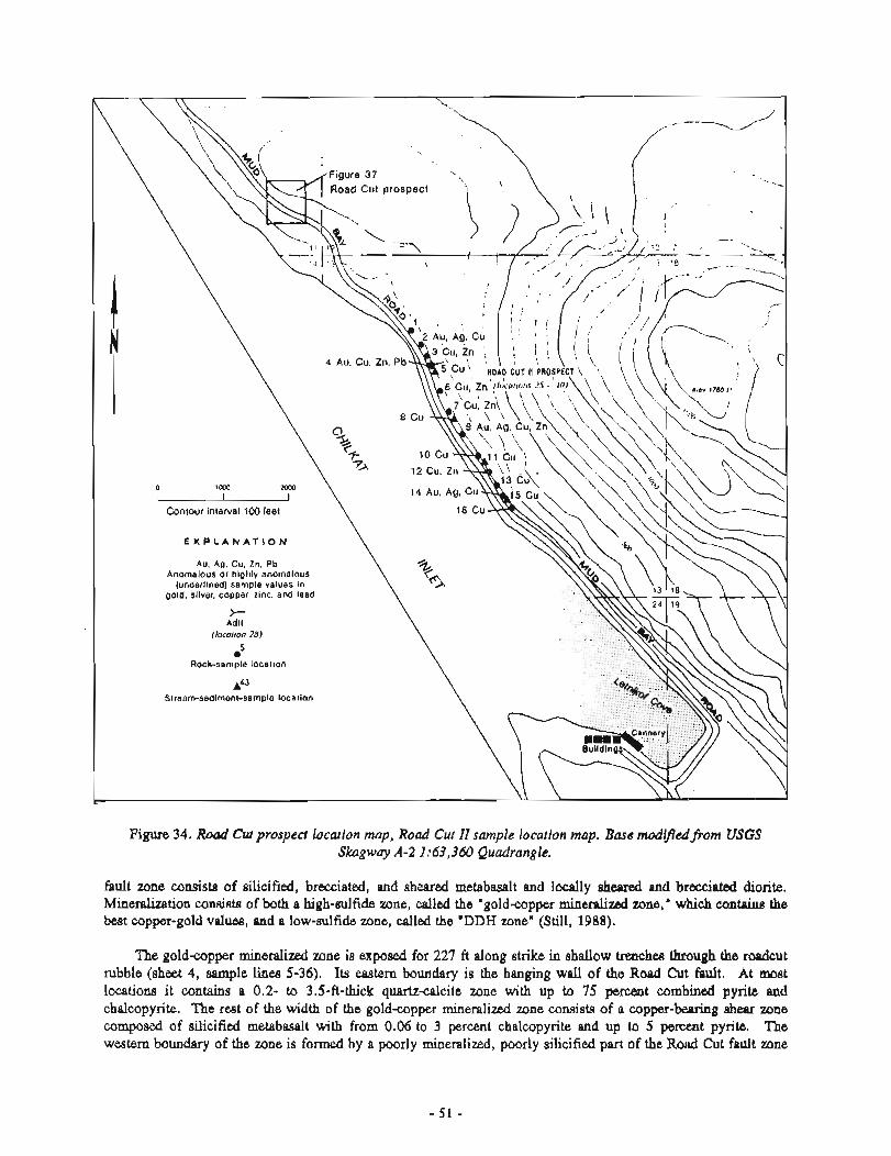
Figure 34. R o d Crrp prospect location map, Road Cur II sample location map. Base modified.,l?om USGS Skagway A-2 1:63,360 Quadrangle.
fault zone consists of si,licified, brecciated, and sheared metabasalt and locally s h d and b m i a t e d disrite. Mineralization consists of both a high-mrlfide zone, d l e d the "goldcopper mineralized zone, " which contniue the best copper-gold v d w , and a low-sulfidc zone, called the 'DDH zone" (Still, 1988).
The goldapper mineralized zone io exposed for 227 ft along strike in shallow trenches through the roadcut rubble (sheet 4, sample lines 5-36). Its eastern boundary is the hanging wall of the Road Cut fault. At most locations it contains a 0.2- to 3.5-A-thick quartzcalcite zone with up to 75 p e m t combined pyrite and chalcopyrite. The rest of the width of the gold-copper mineralized 7 ~ n e consists of n c o p p e r - W g shear zone c o m s e d of silicified ~netabasalt with from 0.06 to 3 percent chalcopyrite and up to 5 percent pyrite. The western boundary of the zone is formed by a poorly mineralized, poorly silicified part of the R d Cut fault zone
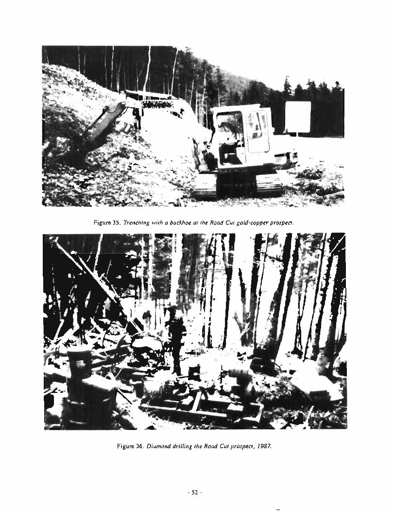
Figure 35. Trenching with a backhoe at the Road Cut gold-copperprospect.
Figure 36. Diamond drilling the Road Cur prospect, 1987.
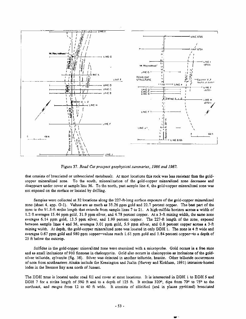
1 LlNE 8705
I LINE 8704 I
I I
I LINE I
,87033
11; I -41
LlNE G - I I - - 1 + f ' 2
ROAD CUT 51 31 STRUCTURE
ul 3f -Easlern V L F 'f 1 iaults a1 oep!n
*m LINE K I r i 4 LINE E
LINE D I LINE C +I1 : I I
,8702.
LINE 8 1 I i I I
I I LINE H
I I1 I I I I "O'Y
LINE J I \ \
o xa n - LlNE 8706
Figure 37. Road Cur prosped geophysical summaries, 1986 and 1987.
that consists of brecciated or unbrecciated metabasalt. At most locations this rock was 1- resistant than the gold- copper mineral id zone. To the south, mineralization of the gold-copper mineralized zone decreases and disappears under cover at sample line 36. To the north, past sample line 4, the goldcopper mineralized zone was not exposed on the surface or located by drilling.
Samples were collected at 32 locations along the 227-ft-long surface exposure of the gold-copper mineralized zone (sheet 4, app. G-1). Values are as much as 33.26 pprn gold and 22.7 percent copper. The best part of the zone is the 91.5-ft strike length that extends from sample lines 7 to 21. A high-sulfide horizon acrasa a width of 1,2 ft averages 15.44 pprn gold, 3 1.9 pprn silver, and 4.78 percent copper. At a 3-A mining width, the same zone averages 6.14 pprn gold, 13.5 ppm silver, and 1.99 percent copper. The 2 2 7 4 length of the zone, e x p o d between sample lines 4 and 36, averages 3.01 pprn gold, 5.9 ppm silver, and 0.8 percent copper scrolls a 3-ft mining width. At depth, the gold-copper mineralized zone was located in only DDH 1. The zone is 4 ft wide and averages 0.67 pprn gold and 980 pprn copper--values reach 1.6 1 pprn gold md 1.84 percent coppee-to a depth of 25 ft below the outcrop.
Sulfides in the gold-copper mineralized zone were examined with a microprobe. Gold occurs in a free state and as small inclusions of 910 fineness in chalcopyrite. Gold also occurs in chalcopyrite as inclusiom of the gold- silver telluride, sylvmlite (fig. 38). Silver was detected in another telluride, hessite. Other telluride occurrences of note from southeastern Alaska include the Kensington and Jualin (Harvey and K i r k h , 1991) intrusion-hosted lodes in the Berners Bay area north of Juneau.
The DDH zone is located under road f iU and cover at most locations. It is intersected in DDH 1 to DDH 5 and DDH 7 for a strike length of 590 ft and to a depth of 125 ft. It strikes 320°, dips from 70° to 7S0 to the northeast, and ranges from 12 to 40 ft wide. It consists of silicified (md iu places pyritized} brecciated
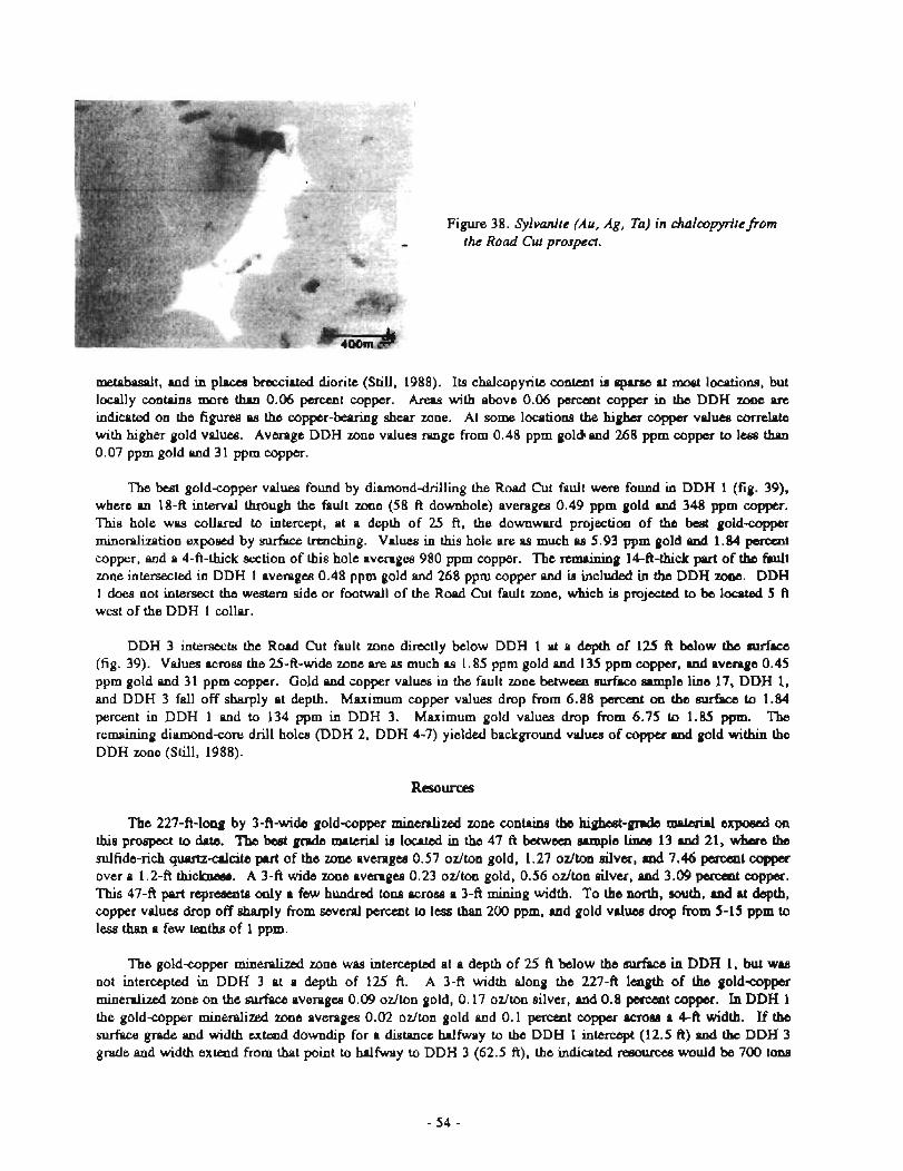
Figure 38. Sylvtan~'te (Au, Ag, Ta) in chalmpyritefiom the Road Cut prospect.
mctabasalt, and in places brccciatcd diorite (Still, 1988). Its chalcopyrite m t m t is sp~rse at most locatians, but locally colltains more than 0.06 pemmt copper. Areas with above 0.06 percent copper in the DDH zone pre
indicated on the figures as the copper-bearing shear zone. At some locations the higher copper valuea correlate with higher gold values. Average DDH zone values range from 0.48 ppm goldc and 268 pprn copper to less than 0.07 pprn gold and 3 1 pprn copper.
The best gold-copper valuea found by diamonddrilling the Road Cut fault were found in DDH 1 (fig. 39), w h m an 18-ft interval through the fault m e (58 ft downhole) averages 0.49 pprn gold and 348 ppm cupper. This hole was collared to intercept, at a depth of 25 ft, the downward projection of the best goldcopper mineralizetion exposed by surface trenching. Values in this hole are as much as 5.93 ppm gold and 1.84 poxcent copper, and a 4-ft-thick section of this hole averages 980 pprn copper. The remaining 14-ft-thick pmrt of the fault zone intersected in DDH 1 averages 0.48 pprn gold and 268 pprn copper and is included in the DDH zone. DDH 1 does not intersect the western side or footwall of the Road Cut fault zon., which is projected to be located 5 ft west of the DDH 1 collar.
DDH 3 intersects the Road Cut fault zone directly below DDH 1 at a depth of 125 ft below the surfsce (fig. 39). Values across the 25-ft-wide zone are es much as 1.85 pprn gold and 135 pprn cupper, and average 0.45 ppm gold and 31 ppm copper. Gold and copper values in the fault zone between surface sample line 17, DDH 1, and DDH 3 fall off sharply at depth. Maximum copper values drop from 6.88 percent on the eurfrrce to 1.84 percent in DDH 1 and to 134 ppm in DDH 3. Maximum gold values drop from 6.75 to 1.85 ppm. The remaining diamondcore drill holes (DDH 2, DDH 4-7) yielded background values of copper and gold within the DDH zone (Still, 1988).
Resources
The 227-A-long by 3-ft-wide gold-copper m i n e d i d zona contains the h i g k d - ~ @ ~ mrteri.l expoml on thisprospecttodate. T b s b e a g n d e r r m t e r i a l L l o c a t e d i n t h e 4 7 f t ~ s a m p l e k 1 3 d 2 1 , ~ t h e sulfide-rich quwtzcrlcite part of the zone averages 0.57 odton gold, 1.27 odton silver, md 7.46 pameat copper over a 1.2-ft thickmas. A 3-ft wide zone averages 0.23 odton gold, 0.56 odton silver, and 3.09 penrat copper. This 4 7 4 part repmeats only a few hundred tons across a 3-ft mining width. To the north, muth, and at depth, copper values drop off sharply from several percent to lea than 200 ppm, and gold valuea dmp from 5-15 pprn to less than a few tenths of 1 ppm.
The gold-per mineralized zone was intercepted at a depth of 25 ft below the surhce in DDH 1, but WM
not intercepted in DDH 3 at a depth of 125 ft. A 3-ft width along the 2274 lmgth of the gold-copper mineralized zone on the surface averages 0.09 odton gold, 0.17 ozlton silver, and 0.8 percmt copper. In DDH 1 the goldcopper mineralized zone averages 0.02 odton gold and 0.1 percent copper acmes a 4-ft width. If the surface grade and width extmd downdip for a distance halfway to the DDH 1 intercept (12.5 ft) and the DDH 3 grade and width extend from that point to halfway to DDH 3 (62.5 ft), the indicated resource8 would be 700 tom
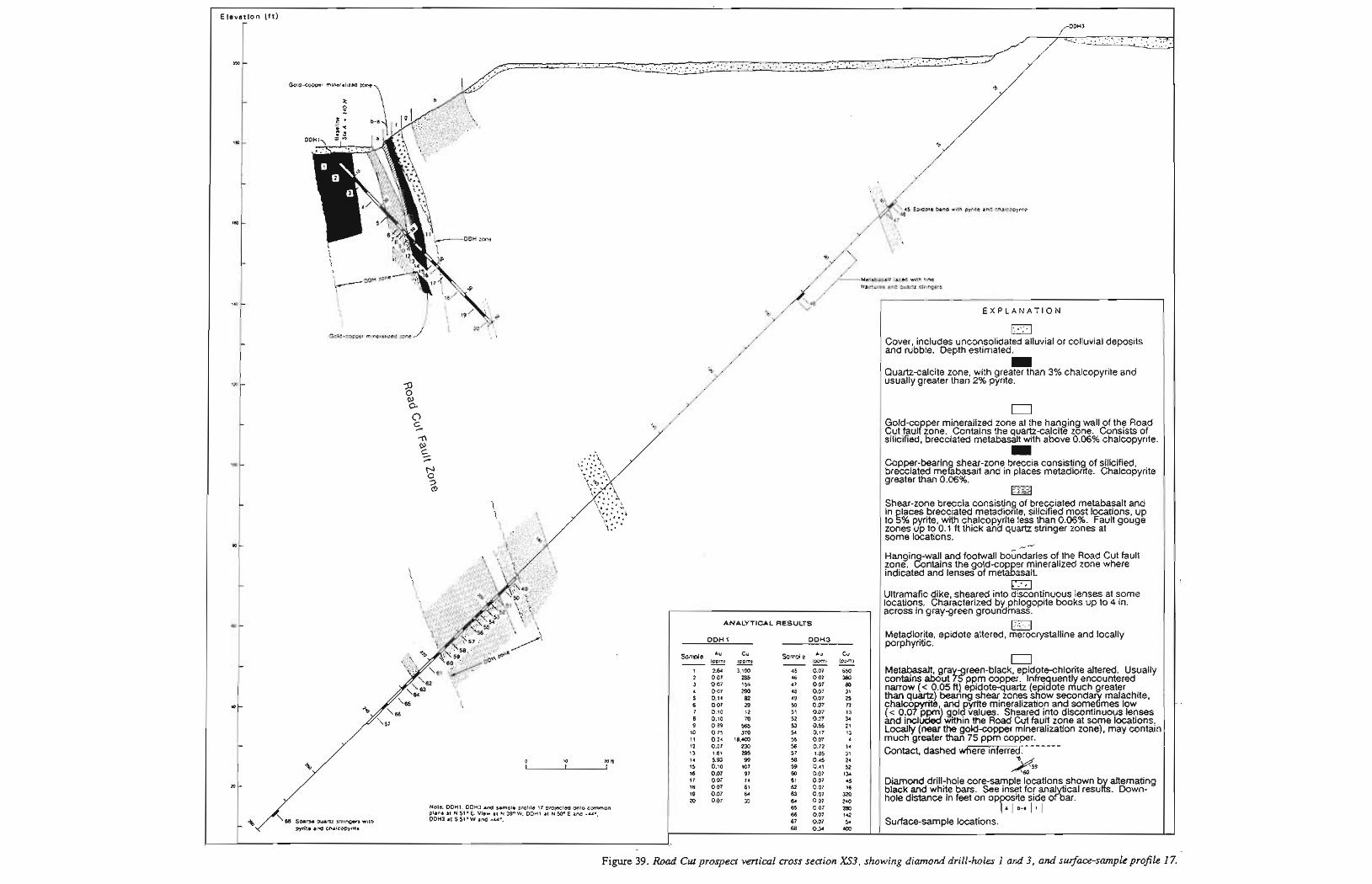
levation (ft) - /"On3 _., . . . \ ..;; :,:; .,,:: . ::.. *..... - .. . . . . . r . -... .: . , .-..... : ."
m -
Gold-copper mineralized mne
-
1w -
-
tw -
- Metabasall laced '-8th tlne fractures and Quartz stringers
140 - E X P L A N A T I O N
Gold-cooper mlneralozed zone Cover, includes unconsolidated alluvial or colluvial deposits - and rubble. Depth estimated. rn
Quartzcalcite zone, with greater than 3% chalcopyrite and l d - usually greater than 2% pyrite.
2 % 0
0 - Gold-co per mineralized zone at the hanging wall of the Road 5 Cut fauzzone. Contains the quartzcalcite zone. Consists of
silicified, brecciated metabasalt with above 0.06% chalcopyrite. rn
I~ - Copper-bearin shear-zone breccia consisting of silicified, brecciated megbasalt and in places metadior~te. Chalcopyrite 3 greater than 0.06%. CD
- Shear-zone breccia consisting of brecciated metabasalt and in laces brecciated metadior~te, silicified most locations, up tog% pyr~te, wrth chalcopyrlte less than 0.06%. Fault gouge zones up to 0.1 ft thick and quartz strlnger zones at some locations.
m - ./--' Hangin wal! and footwall boindaries of the Road Cut fault zone. &ntains the gold-cop er mineralized zone where indicated and lenses of metagasalt.
- Ultramafic dike, sheared into discontinuous lenses at some locations. Characterized by phlogopite books up to 4 in.
, across In gray-green groundmass.
w - ANALYTICAL RESULTS a
DDH 1 DDH3 Metadiorite, porphyritic. epidute altered, merocrystalline and locally
Au Cu Au Cu
- (ppmt (opmt -- - (porn) (ppm) 1 2.64 3.100 45 007 650
0 2 0.07 285 46 0.07 360 3 0 0 7 155 47 007 80 4 0.07 290 48 0.07 31 5 0.14 82 49 0.07 25 6 0.07 29 50 0.07 77 a - 7 0.10 12 51 0.07 13 8 0.10 m 52 0.27 34 9 0.89 565 53 0.55 21
10 0.75 370 54 0.17 13 11 0.24 1a .m H 0.07 4
- 12 0.07 230 56 o .n 14 Contact, dashed where inferred:------- 13 1.61 295 57 1.85 31 14 5.93 99 53 0.45 24 15 0.10 107 59 0.41 52 16 0.07 97 BO 0.07 I34 17 0.07 74 61 0.07 45
2O - 18 007 61 62 0.07 16 19 007 64 63 0.07 M 20 0.07 33 64 0.07 240
Note: DDUl. DDH3 and sample prolile 17 prolacled onto common 65 0.07 280 plane at N 51- E. Vmw at N 390 W. ODHl at N 50° E and 4'. 66 0.07 142 D D H ~ 11 s 51- w and -us. 67 0.07 54 Surfacesample locations.
pyrite and chalcopyrite 60 034 100 ;
J,- I I
Figure 39. Road Cut prosped vertical cross section XS3, showing diamond drill-holes 1 and 3, and suface-smpk profik 17.
at 0.09 ozlton gold, 0.1'7 ozlton silver, and 0,8 percent copper at a 3-ft width (this includes the highest grade 47 ft previously described) and 4,729 tons at 0.02 ozlton gold and 0.1 percent copper at a 4-ft width.
Conclusions
Although the grade of material within the Road Cut fault zone was not high enough to constitute an economic deposit, sufficient grades for small tonnages have beer1 found that encourage further examination of the unexplord 1,100-A length of the fault zone, Also, the data generated encourage tracing and physical testing of the R w l Cut fault zone beyond its presently known 1,700-ft length. Geophysics indicates targets for physical testing, additional geophysical tests, and soil sampling to the east of the Road Cut fault zone (Still, 1988).
ROAD CUT I1 PROSPEC']:
Mineralization of the Road Cut Il prospect is about 1 mi south from the Road Cut prospect between the 4- and 5-mi signs dong the Mud Bay Road (fig, 34). At most locations a cliff consisting of metabasalt (or at some locations, diorite) forms the east edge of the roadway, possibly representing a fault-line scarp along an eastern splay of the C h i h t fault zone. Mineralization consists of epidote-altered metabasalt and epidote bands up to 2 ft thick h t colitain pyrite, chalcopyrite, and 1-1 sphalerite. t
An old d i t , located several hundred feet southeast of the 4-mi road sign, penetrates metabasalt for about 30 ft. The adit was not driven on mineralized rock, but a band of metabasalt adjacent to it contains chalcopyrite.
Two 440-ft-long magnetic line... were run over the beach arid road and then up the escarpment near the 5-mi sign (5 mi from Haines along the Mud Bay Road). Here a prominent magnetic low st~iking 323O is located about 35 ft east of the roadway (Still, 1988).
Samples were collected on the east side of the road through shallow excavations hi the roadway rubble and at a few bedrock exposures. Selected high-grade samples contained up to 0.21 ppm gold, 2.5 pprn silver, 0.695 percent copper, and 1.83 percent zinc (fig. 34, app. G-3). Samples were limited to the eastern fault margin (east side of the road) because roadway fill, marine sediments, and the, waters of the Chilkat Inlet hamper examination of the main fault rxtne itself.
ZINC BEACH OCCURRENCE
The Zinc Beach occurrence, 1.5 mi south of Flat Bay on die east side of the Chilkat Peninsula, is located in metabasalt on a north-northwest striking iineament that is likely a splay off the fault that rum through Flat Bay (sheet 1). Analytical results are in sheet 1, F140-141 and sheet 2, no. 885, locs. 37 and 38 of Gilbert and others (1991b).
Two stream-sediment samples collected from a dry stream that drains the northwest trending lineament contained up to 0.583 pym gold, 1 pprn silver, 162 pprn zinc, and 164 pprn copper. A soil sample collected in the roots of o tree contuked 0.019 pprn gold, 240 pprn zinc, and 460 pprn copper. Samples from brecciated sphale~le-bearing h a l t boulders up to 1 ft thick and 2 ft long contained up to 6.23 pprn gold, 13 pprn silver, 27 percent zinc, 2,600 pprn copper, 13 pprn ttuigsten, and 50 pprn wsnic. The source of these boulders is likely the lineament or cliffs adjacent to it. Iron-stained metabasalt rubblecrop with chalcopyrite, pyrite, and malachite in a quartz h o t contained 0.446 pprn gold, 220 ppm zinc, and 8,400 pprn copper. The murce of the rubblecrop was an iron-stained shear zone near the top of a basalt cliff near the beach.
A stream-sediment sample collected at a location 0.8 mi north from the Zinc Beach occurrence and along the lineament that includes Zinc Beach contained 0.024 pprn gold, 1.5 pprn silver, 3,000 pprn zinc, 1,150 pprn copper, and 580 pprn lead. This trend is a target for detailed examination.
BATTERY POINT OCCURRENCE
The Battery Point occurrence is located on the east side of the Chilkat Peninsula, about 0.5 mi south of Battery Point, where a 100-&-high metabasalt cliff has a few patches of malachite stain (sheet 1). The occurrence is near the contact between metabasalt and an ultramafic intrusion. Selected high-grade samples of metabasalt from the cliff and float below it, containing disseminated chalcopyrite, contained up to 0.51 pprn gold and 2,650 pprn copper (she& 1, F134 and sheet 2, nol 850 of Gilbert and others, 1991b). A 100-&-long random chip of metabasalt with disseminated chalcopyrite contained 290 pprn copper and leas than 0.07 pprn gold,
SHIKOSI ISLAND OCCURRENCE
The Shikosi Island occurrence is located on the north end of Shikosi Island and consists of a narrow epidote- altered silicified shear zone that contains chalcopyrite and chalcopyrite hosted in metabasalt (fig. 40). Samples collected from this zone contain up to 0.05 ppm gold, 6.7 pprn silver, 3,000 pprn zinc, and 2.74 percent copper (app. G-4). This shear zone approximately aligns with similar mineralization found at the Islands Copper prospect, described below.
ISLANDS COPPER OCCURRENCE \
The Islands copper occurrence is located on the south end of Kataguni Island (fig, 40). The mineralization is located in metabasalt sea cliffs up to 50 ft high that contain numerous narrow shear zones at various orientations. Some of the shears are silicified and contain copper or copper-zinc mineralization. Samples collected from these 0.2- to 1.4-ft-thick shearantrolled veins contain up to 2.54 ppm gold, 22.5 pprn silver, 6.9 percent copper, and 2.14 percent zinc (app. G-4).
TALS AN1 ISLAND JADEITE OCCURRENCE
A jadeite occurrence has been reported on Talsani Island (Wells and others, 1986). l%e area was briefly investigated and jadeite was not found. However, some epidote-rich bands in metabadt were anomalous in copper (fig. 40).
ANOMALOUS AREAS
To follow up discoveries of gold-copper mineralization in the Chilkat Peninsula, examinations were made near major Chilkat Peninsula fault systems. This work consisted of sampling mineralized rock and collecting stream sediment samples. Sheets 1 and 2 of Gilbert and others (1991b) and figure 34 show the locations of samples. Sixtyeight rock, five panancentrate, one soil, and 46 stream sediment samples were collected. Of these 120 samples, 79 are anomalous in gold, silver, copper, or zinc. Samples contain up to 0.79 pprn gold, 5.7 pprn silver, 1.23 percent copper, and 3,000 pprn zinc. There is pervasive goldapper mineralization in the Chilkat Peninsula mineralized zones; the largest part of the anomalous samples collected border the fault that cuts the middle of the B d l a at Letnikof Cove and Flat Bay. Areas with a significant clustering of anomalous or highly anomalous samples are:
1. The Road Cut prospect and Mount Riley gulch area. Here stream-sediment samples, collected in intermittent drainages just east of the Road Cut goldcopper mineralized zone, and a series of samples collected in the streams and gulches that drain the northwest side of Mount Riley are anomalous or highly anomalous in gold and copper (up to 0.31 pprn gold and 611 pprn copper) (sheet 2 of Gilbert and others, 1991b).
2. A series of narrow gulches that drain the southwest side of Mount Riley between the Road Cut I1 prospect and south to Letnikof Cove. Stream-sediment samples collected from these gulches are anomalous in copper or copper and gold (sheet 2 of Gilbert and others, 1991b). The samples contain up to 465 pprn copper and 0.79 pprn gold.
3. The area &at drains the 8011th side of Mount Riley, Stream-sediment samples coliected here am moxdous in gold and copper (sheet 2 of Gilbert and others, 1991b); they contain UP to 0.07 ppm gold and 286 ppm copper.
4. The east side of the Chilkat Peninsula. Bedrock, float and stream-sediment samples collected here are anomalous in gold, silver, copper, and zinc (sheets 1 and 2 of Gilbert and others, 1991b). The samples contain up to 0.114 ppm gold, 2.5 ppm silver, 5,300 ppm copper, and 3,000 ppm zinc.
CONCLUSIONS
Although examination of the Road Cut prospect did not reveal an economic deposit, it did reveal wfficient tonnages and grades to encourage additional examination along its defined structure and parallel structures to determine its extent beyond its present known limits. Samples collected from prospects, bedrock locations, and from streams indicate that goldapper mineralization (and local zinc mineralization) is pervwive in the shear and fault zonm of the Chilkat Peninsula. A number of these samples indicate areas with important exploralion potential for fal~ltcontrollcd goldapper mineraIization.
PLUT'ONLC GOLD D E C m A N T , HAINW-KLUKWAN AREA
Three major episodes of plutonism formed most of the plutonic roch, in the Hain--Klukwan area (Taku t e m e ) (Gilbert and others, 1991a). The first episode occur4 during mid-Cretaceous time and includes the Haines mafic-ultramafic complex, the Mount Kashapak pluton, and the Klukwan rnafic-ultramafic complex. During Late Cretaceous - Early Tertiary time the second episode of plutonism prduced the Northern Border llnd Tanani plutons, interpreted by Gilbert and others (1991a) to be the western margin of the Great Tonalite Sill complex. The third episode produced a few bodies of granite and granodiorite, including the Klutsha Mountain pluton, during Tertiary(?) time (Gilbert and others, 1991a).
Major-oxide chemical analyses of plutonic rocks from the Haines-Klukwan area were scored by the gold discriminant analysis described earlier (table 1). Most of the mid-Cretaceous Mount Kashagnak plutoll exhibits too high an oxidation state to appear favorable for producing nonporphyry gold deposib (table 1, fig. 31). However, many of the analyses of the gold-baring Jualindeposit 'diorite" 15 km southeast of the study area indicate oxidation states similar to those of the Mount Kashagnak pluton; they also appear unfavorable with nonporphyry gold discriminant functions (Newberry, written communication). Because of the similarities between the Mount Kashagnak pluton and Jualin "diorite" disci~ssed by Gilbert and others (1991a), there may have bee11 a gold-beiiring episode in the history of the Mount Kashagnak pluton, perhaps represented by the Road Cut prospect.
The Northern Border pluton, located within the map area, and the Ferebee I'lutonic Complex, to the east sf the map area (Bedman and others, 1984; Gilbert and others, 1990), are the only plutom that appear to be favorable for nsnprphyry gold association in the Haines-Klukwan-Skagway area. The favorability of these Great Toaalite Sill-related plutons for nonporphyry gold systems is consistent with die spatial and, perhaps, genetic relationsllip tKh4reefl some gold deposits within the Juneau gold belt and the Great Tonalite Sill. The Tnnani pluton, also thought to be part of the Great Tonulite Sill, yields low discriminant scoreo, but the pluton's elevated strontium content suggests that alteration of the body has reduced the accuracy of the disc-t analysis (table 1, fig. 31). Samples from the Tertiary(?) Klutsha Mountain pluton were too altered to yield reliable discriminant scores.
PLACER DEPOSITS OF PORCUPINE AREA
MPNING HISTORY
In the spring of 1898, packers on the Dalton Trail panned gold from the gravels of the Klehini River. Shortly rlfter the discovely, most of the streams in the Porcupine area were staked; however, many claims were
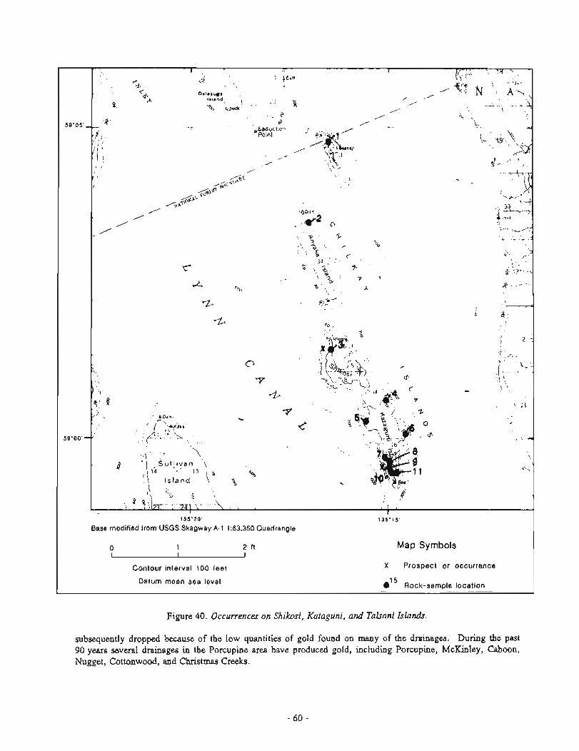
Figure 40. Occurrences on Shikosi, Kataguni, and Tahani Islandr.
\
subsequently dropped because of the low quantities of gold found on many of the drainages. During the past 90 years several drainages in the Porcupine area have produced gold, including Porcupine, McKinley, Cahoon, Nugget, Cottonwood, and Christmas Creeks.
ssoos
I' I I - , , , < \ .+
d Ckl i k.1.
4 U \; , 4 , - 2-
c balmawn , %;T ~r lana / '
% N A \ , 8
=?a ! - "s I B <>& , , * - - .
/ 9 I 'i
,- 9' b0 - A - .., . d .
-1
\ ';- v , \ . 11 I
I r'-
1- 3, ' - 2 - i I > I
~ 1 ', _I
t ,,LcT~u' - -
5Q00O'"
+@ , " 7 7 b \ .. *< '
.b ,-.a
/ ~ P j r * / 3 k
I . d o
A " 7 ,
I / - ,.A ,*./
9 5 + & - -
1 S
, , 1 ,
C ' ,- 1"
f "o % % 5 0 - 7 , < i % p ' A 'b A .p 3
rz- *> -0 - w
6 ,a
60
1,
I 2 "
i / ^
c' , k - j . . i
-Y <*\%L :*- - cSi I '
1 .* . U T- - r \
4 4 8 . 3 5
$ 2
/ A Dam
-Y .. ip'-&p'. C 0
+4! r c ', t 1
I rl
* \
4 S u I ! ~ v a n , 1 ,; .
13 , . \ Isband \,
B 5
,\ .>
\ 4 " , 7z1 -
a - i, -
1 I >
1 135'20' 135"15 '
Base modified from USGS Skagway A-1 1 63,360 Quadrangle
o 1 2 tt Map Symbols I I I
Contour ~nterval 100 feet X Prospect or occurrence
Datum mean sea level e1 Rock-sample locatron ----
Followi~ig the studiea of Wright (1904) and E a k h (1919), B.D. Stewart reported on placer operations in the Porcupine area in 1926 (Stewart, 1926). W.B. Beatty worked on Porcupine Creek in 1936 and wrote a comprehensive therris coiicerning the placer deposits of the Porcupine Creek area (Beatty, 1937). An account of mining history of the Porcupine Creek area has been compiled by Roppel (1975). Bundtzen (1986) md Hoekze~na and o t h m (1986) reported on the placer deposits and describer1 the glacial geology of the Porcupine Creek area; the following discussion s f placer deposits is taken largely from their work.
Production records for the Porcupine placer deposits are sparse. Minimum estimated production through 1985, compiled by Hoekzema and others (1986), is 79,650 oz. Only very minor production has been reported since 1985. Placer-gold occurrences are found on several other drainages in the area, including Big Boulder and Little Boulder Creeks, the Tsirku and Klehini Rivers, and western drainages to the Chilkat River north of Mosquito Lake, but no production is known.
PORCUPINE CREEK
Mining started on Porcupine Creek in 1898. Reported production averaged as high as 9,000 oz of gold per year until 1906, when high water destroyed much of the workings (Beatty, 1937). During the early years relatively primitive methods of mining, such as pick and shovel, small sluices, and rockers were used to recover the gold. Ground sluicuig (booming) also became a popular method of minin gold. This technique requires the diversion of the creek into a flume or a predug channel to remove large bou f ders from the original channel and loosen gravel deposits. Water is then allowed to flow back into the original channel to remove the loosened gravel and concentrate the gold in depressions. Gold is then recovered after the stream has been diverted back into the flume or diversion ditch.
In 1N7, Porcupine Mining was organized to consolidate the workings in the area. The company erected a flume 1 mi below the junction of McKinley and Porcupine Creeks at a reported cost of $200,000 Foppel, 1975). This development opened up the lower end of Porcupine Creek to gold mining. The company operated until the flume was destroyed by a disastrous flood in 1915; it had an average yearly production of 3,000 oz (Beatty, 1937).
In 1916, the operations of Porcupine Mining were taken over by the Alaska Corporation. The old flume was repaired and a new flume constructed to feed water to hydraulic ruining operations. Mining continued until September 1918, when another flood destroygd the flume. Over 6,000 oz of gold was produced between 1916 and 1918 (Beatty, 1937).
The next large mining operation began in 1926, when Porcupine Gold Mines, which subsequently became Alaska Sunshine Ciold Mining, managed by August Fritsch, took over the Porcupine Creek property. This company comtructed several of the existing buildings at the townsite of Porcupine and a 12,000-ft-long elevated flume to supply hydraulic water at any need4 location on Porcupine Creek below its junction with McKinley Creek. The headgate of the flume was located 0.5 mi above the mouth of McKinley Creek. McKinley Creek was spanned by a bridge 160 ft almve the creekbed, a few hundred yards above its junction with Porcupine Creek. The flurne and related structures were completed near the end of 1928. Mining began in 1929 but was shut down at the end of the season because of poor returns. Following extensive exploration work, mining operatiom on Porcupine Creek restarted in 1935 by processing gravels from the MacElvery (dry) channel (Beatty, 1937). Work continued into 1936, until the bridge over McKinley Creek was destroyed by a rockslide. Fritsch died in 1936 and large-scale mining on Porcupine Creek ceased. Fritsch's records claimed that Mash Sunshine Gold Mining recovered $1,700,000 worth of gold from the Porcupine claims, but this prduction has not been substantiated by either U.S. Mint m r d s or Smith (1933).
Activities s i n c ~ the World War I1 have been sporadic, but a brief mining resurgence occurred in 1959-1960, when five small o~xrations employing 15 people worked various claims on Porcupine Creek and its tributaries (Williams, 1960). When gold prices mared in the late 1970s and early 1980s, mechanized placer mining produced up to several hundred ounces mual ly until 1984. Jo Jurgeleit, James McEaughlin, Merrill Palmer, John Schnabel, the Peterson family, and others continue to take out small amounts of placer gold From their claims. Activity since 1985 has been limited to small-scale hand-placer mining or limited mechanized operations.
MCKINLEY CREEK
Mining on lower McKinley creek (below Cahoon Creek) began at about the same time as activity on Porcupine Creek. Most of this section was mined out by 1904. From 1903-1916, old channels of McKinley creek up to 200 ft above the current creek level were mined successfully by Cahoon Creek Mining. Their last operation consisted of driving a tunnel through a narrow Mrock spur above McKinley Falls to divert the creek into Porcupine Creek and dry up the plunge pool and lowermost section of McKinley Creek (Batty, 1937). Over 4,4QO oz of gold were recovered during a few weeks' time in 1916 from the plunge pool and streambed below the falls.
The lower section of McKinley Creek has been hand mined sporadically by individuals and small groups through the years. Recent attempts have been made to mine the plunge pool below McKinley Falls, and suction dredges have been used to mine the channel.
Stewart (1926) reported that in 1926, six men were mining on Upper McKinley Creek (above Cahoon Creek) about 1 mi above its mouth using "booming" techniques. Reportedly, $60,000 was expended on the property, but no production figures are known. Upper McKinley Creek has been prospected in recent years by using suction dredges and hand-placer techniques; production has not been reported.
CAHOON CREEK
The lower 0.5-mi section of Cahoon Creek was extensively mined by Cahoon Creek Mining from 1908 to about 1913. Wright (1904) reports that a small hydraulic plant was set up and operated at the face of Cahoon Glacier in 1902 and 1903. On the basis of the limited extent of the workings, this operation was apparently unsuccessful. A hydraulic plant was also worked on Cahoon Creek from 1910-1913 (Brooks and Capps, 1924). Hand-placer methods have been used to prospect the creek gravels in more recent years.
GLACIER AND CHRISTMAS CREEKS
Glacier Creek and its tributaries were originally prospected and staked in 1899 and 1900, but were undeveloped because of the great gravel depths and low ore grades (Beatty, 1937). A keystone drill was used to prospect lower GIacier Creek in 1911, apparently with encouraging results. A mill was erected and a 2,000-ft- long flume constructed. Mining operations began in 1916 and continued into 1918. Recovery was poor and the operation closed down after working a 114-mi section of stream channel. Beatty (1937) reports that a $250,000 was spent to develop the property based on the drilling returns, which later proved to have been salted.
A small eastern tributary to Glacier Creek, known locally as Christmas Creek, was worked by a small hydraulic plant in 1910; the property was patented in 1916. A small heavy equipment operation worked near the mouth of Christmas Creek during the late 1970s with meager results. A total production of 200 oz of gold is estimated on the basis of tailings present and grades determined during 1985 field work.
NUGGET CREEK
Placer gold was discovered in Nugget Creek in 1899. Sporadic mining is reported to have occurred from 1902 to 1913, 1929, and since 1980 (Hoekzema and others, 1986). Eakins (1919) reports that about 350 oz of gold was produced by a small hydraulic operation between 1902 and 1909. The operation processed gravels near the mouth of Nugget Creek canyon by diverting the creek into a flume. This developement both freed the creek channel from water and supplied power to run a demck used to remove large boulders from the creek. The remains of a small hydraulic plant exist on the east side of Nugget Creek about 1.5 mi above its junction with the Tsirku River. Suction dredges were used to test the gravels in the lower section of Nugget Creek canyon behveen 1980 and 1985 with encouraging results. The alluvial fan at the mouth of Nugget Creek was patented in 1934 (Hoekzema and others, 1986).
CO'ITONWOOD CREEK
Gold w a discovered on C~ttonwoocl Creek in 1899, but workings on the creek never produced gold in significant amounts. The alluvial fan extending along the Tsirku River from Cottonwood Creek to below Nugget Creek wm prospected with encouraging results before 1912, and a company was formed to dredge the alluvial-fan gravels about that time (B~wks, 1913). Fifty claims were staked to cover the fan, but the ground was abandoned in 1916. Parts of the Nugget-Cottonwood Creek fan were patented in 1934.
OTHER STREAMLS
Gold has been discovered on several other drainages in the Porcupine area. These include Big Boulder and Little Boulder Creeks and the Little Salmon River. None of these drainages have been producers, according to available historical data. However, evidence of recent suction dredging and hand-placer work exists on the Little Salmon River.
GLACIAL GEOLOGY
The bedrock hi the Porcupine area consists of metamoq)hoseti sedimentary roch (slab, phyllite, and marble), which have been intruded by igneous rocks of Early Cretwceouu and mid-Tertiary age (Gilbert and others,l99la). Impressive r d t s of extensive glaciation are also evident (sheet 5), but specific limits of the various Pleistocene and Holocene glacial advances are not well understood. Recent glaciation throughout southeastern Alaska h masked all evidence of ice activity before about 70,000 years before present (BP) (Mann, 1986), and virtually all glacial deposits and landform observed today in the Porcuphie area are probnbly Late Wisconsinian (30,000 to 10,000 year BP) and younger.
The Holocene glacial chronology worked out by Mann (1986) in the adjacent Glacier Bay legion shows a four-phare history of glacial maxima at 9,000 to 13,000 year BP, 5,000 to 6,000 year BP, 2,500 to 3,600 year BP, and about 1,500 year BP, each separated by periods of deglaciation, downcutting or incision of former glacial valleys, and stream aggradation of major-trunk meltwater streams. These PleisWne glacial advmcea and retPeat8 resulted hi at least three, and possibly four, bedrock-incised channels or terrace levels in the valleys of Porcupine, Cahoon, and McKinley Creeks (shown as Qatl, Qat2, and Qatj on sheet 5 and fig. 41). In most cases, the remnant8 of these channels apparently avoided ice scour and were unaffected by later events, except for deposition of glacial drift. The oldest recognized terrace level occurs at 250 to 300 ft above present canyons of McKinley and Porcupine Creeks, followed downstream by channels at 140 to 200 ft, 50 to 75 ft, and a final and most youthful terrace that is 25 to 40 ft above the modem drainages. The oldest terrace level (Qatl) may be a composite of fluvial material and drift not incised into bedrock. Radiocarbon ages suggest that ale third t e r n level on Porcupine Creek was deposited after the third Holocene glacial advance (2,500 to 3,600 year BP) (Bundtzen, 1986).
The last Holocene advance (1000-1500 year BP?) occupied 1- to 2-mi stretches of Porcupine, McKinley, and Glacier Creek valleys b l o w present glacial termini. Beatty (1937) reports that the glacier on Cahoon C l e k retreated nearly 1 mi from 1898 to 1937, indicating that the region is still undergoing deglaciation.
Besides leaving W d multiple drift limits, bedrock-incird bench chaunels, trimlines, and hanging valleys, multiple glacial episodes also p r o d u d perched alluvial and c:olluvial fans and ice-marginal meltwater channels (sheet 5, fig. 41). The alluvial-fan complex of Porcupine and Glacier Creeks (sheet 5) encountered more than one period of aggradational development, and the former fan apex was probably once at least 1 mi south of its present position. A distributary channel of this fan probably spilled over into the drainage now occupied by Wplker Lake.
Development of alluvial fans on Cottonwood and Nugget Creeks have been significantly influenced by earlier west-to-east glacial-meltwater features that drained Late Wisconsin or Holocene valley ice in the Tsirku River. Former ice ~narguial meltwater channels have left notched, belxeaded drainages in the Herman Creek and Walker Lake area (fig. 41), along the Klehini River near the United States-Canada border, and in isolated sections
Modern meander cut
Southern limit of Beatty (1) investigation
E X P L A N A T I O N
Qat 3-Most recent incised bedrock channel
Qat 2-Bedrock channel
Qat 1 -Oldest channel
85 BTc3 Radiocarbon dating locality (see tables 1 3 )
Channel field check
Figure 41. Abandoned channek on lower Porcupine Creek
of the Tsirku River. Modem meltwater channels are incised in glacial drift, in contrast to the bedrock incision of fluvial channels in the Porcupine Creek watershed. Elevated, modern terrace alIuvium and alluvial fans of Late Holocene age parallel the modern floodplains of the Tsirku and Klehini Rivers and are a result of receut periods of stream aggrsdation during distributary channel development.
PLACER GEOLOGY
Heavy-mineral placer deposits in the Porcupine area formed during multiple glaciofluvid cycles. Heavy- mineral placer concentrations occur in bench deposits in incised bedrock channels and glacial till, alluvial fans, and modern-stream incisions. High stream gradients (fig. 42) indicate that the Porcupine area, as a whole, is immature and is nested in a high-energy fluvial environment. The average stream gradient of the study area is about 500 ftlmi, compared with averages of 80 to 150 ftlmi in many interior-Alaska placer districts.
Bedrock sources of most heavy-mineral concentrations, including the placer gold, have been identified by Eakins (1919), Beatty (1937), Still and others (1985), Bundtzen and Clautice (1986), and H~kzema and others
Hanging valley
Nugget fan ' ; --+-- cottonwood fan / \ Glacier alluvial fan
Porcupine fan \
Figure 42. Stream gradients in the Porcupine area.
(1986). The most likely bedrock sources are crosscutting quartz sulfide - gold fissure veins associated with altered mafic dikes cutting Porcupine Slate in the McKinley and Gahoon Creek drainages. Pyritiferous me8 in the Porcupine Slate also contain anomalous gold values ranging up to 2 ppm gold. Localized silver-lead-(gold) deposits, such as those identified in the Summit Creek drainage, may also contribute to heavy-mined placer concentrations (Still and others, 1985, 1987; Gilbert and others, 1991b). Placer gold in Christmas and Hennan Creeks may bo derived from the Porcupine Slate, or alternatively from stratifom mineral concentratiom in metavolcanic rtxks, such as in the Glacier Creek deposits.
Gold fineness on Porcupine Creek and its incised bench deposits ranges from 841 to 909 and averages 866 (seven samples) (app. H-1). There does not appear to be a noticeable difference in fineness between the lower elevated fluvial, channels and the motlem steeam, though Beatty (1937) mentions that the highest bench levels on Porcupine Creek have a distinctly lower fineness than gold mined in the modern stream.
Placer-gold fineness from McKinley and Cahwn Creeks ranges from 786 to 859 and averages 821 (four samples); gold extracted from two quartz veins in the area averages 750 (app. H-1) Hoekzema and others, 1986). Fineness predictably increases downstream with increasing distance from the probable lode sources in these two drainages (Koshman and Yugay, 1942). Fineness downstream change; from an average of 821 on McKinley and Cahmn Creeks to an average of 866 on Porcupine Creek.
Fineness of placer gold collected from Nugget and Cottonwood Creeks averages 779 (three &unples), whereas ha t of Glacier and Christmas Cmks drainage averages 865 (two samples), which is very close to that found in lower Porcupine Creek (app. H-1).
The average overall fineness from the Porcupine area, with the Boyle (1979) method, is 837, compared to 820 reported by Smith (1941), who records from four locations on Porcupine Creek. The range of fineness
in the Porcupine area is consistent with those reported by Moiser (1975) for epithermal and lower mesothermal temperatures of formation. Bullion was analyzed for the trace metals copper, lead, zinc, and antimony besides the precious metals (~pp. H-1). Significantly, samples containing detectable copper were found in McKinley and Cahoon Creeks, pahap suggesting recent association with lode sources. The gold-to-copper ratio is much too high for typical gold plrrcerr, of any temperature range, but the presence of antimony in single samples on Cahoon and Porcupine C& also suggests formation in epithermal or lower mesothermal temperature ranges (Moiwr, 1975).
Bundtzen (1986) and Hoekzema and others (1986) report analyses of heavy-mineral concentrates from nine streams in the Porcupine area (app. H-2). A preponderance of magnetite in virtually all drainages suggests that magnetometer exploration techniques may be useful in delineating buried channels and other heavy-mineral concentrations. Pyrite is predictably abundant in Porcupine, Cahoon, McKinley, Nugget, and Co t tonwd Creeks, where it may be derived from both pyritiferous zones in the slate and epigenetic-vein deposits. Scheelite and (uncommonly) cassiterite are present in McKinley, Cahoon, and Cottonwood Cteeks, but the concentrations are probably not economical. Barite is abundant in Glacier Creek and in the immature placers of the Herman Creek area. Its presence in the Herman Creek drainage suggests that barite mineralization may exist in the metavolcanic rocks underlying the glacial drift that blankets the area. Massive barite-sulfide deposits in metavolcanic rocks at the head of Glacier Creek are probably the source of barite in this drainage.
%
Placer gold from McKinley, Porcupine, Nugget, and Christmas Creeks was microscopically examined to delineate characteristics of transport and origin of the gold that has been mined. Consistently, two distinctive types of gold are present in the analyzed concentrates: well-worn, rounded, bright "nugget" gold which shows evidence of fluvial tramport; and small wirelike grains with quartz and undetermined gangue mineralogy that show little evidence of stream transport. Either more than one lode source is present, or proximal lode gold and "nugget" gold have been transported by fluvial mechanisms (Bundtzen, 1986).
Bundtzen (1986) and Hoekzema and others (1986) report gold size ranges from placer samples h r n the Porcupine area. Beatty (1937) and the authors have noted a general lack of fine gold (100 mesh or smaller) in the Porcupine area. The extremely highenergy nature of placer formation in the area suggests that virtually all fine gold has been flushed down the streams and possibly out of the study area. However, the Glacier Creek, Porcupine Creek, and Nugget Creek alluvial fans represent significantly lower energy fluvial environments than those of the main feeder streams entering into the lower valleys, which suggests that alluvial fans may have accumulated part of the fine-gold fraction absent in the main-production streams.
Gold was panned from a thick section of glacial till exposed in Christmas Creek, a tributary of Glacier Creek. The gold was apparently interspersed throughout at least the lower 6 ft of till with no apparent concentration on bedrock. The gold is very fine grained, well-worn "glacial" gold, possibly due to the milling effects of glaciation. Although Christmas Creek was the only locality where gold was recognized in till, its existence both there and in till of other drainages mentioned by Beatty (1937) suggest that "glacial gold" may be an intermediate host between hard-rock sources and downstream accumulations in fluvial deposits.
RESULTS OF SAMPLING
In 1985, the USBM collected 78 reconnaissance, 53 channel, and four site-specific bulk-placer samples. All the major streams in the placer area were sampled, with at least one sample taken from each drainage (app. H-3; fig. 43). All site-specific bulk samples were taken from lower Porcupine Creek (app. H-3). The p d u r e for collecting reconnaissance, channel, and site-specific placer samples is given by Hoekzema and others (1986).
Sample locations are plotted on sheet 5 (map nos. 1-22, 79-132), figure 44 (map nos. 2344), and figure 45 (map nos. 65-78); sample results are listed in appendix H-3. Of the 78 reconnaissance and 53 channel samples collected, 35 were found to contain values greater than 0.005 oz/yd3 gold.
Results from reconnaissance and channel sampling were used to give each stream a mineral-development- potential rating for placer gold by using one of four levels: "high, " "moderate," "low, " and "unknown" (table 2).
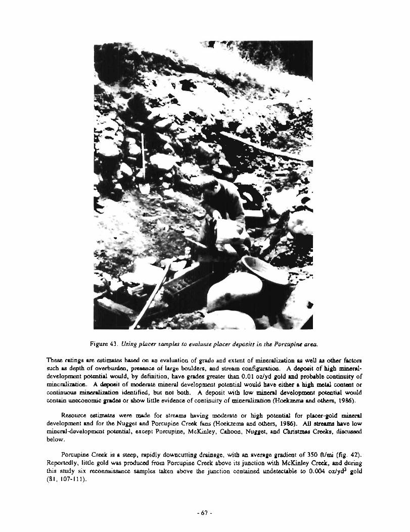
Figure 43. Using placer samples to evaluate placer deposits in the Porcupine arm.
These ratings are estimates based on an evaluation of grade and extent of mineralization as well 9s other factors such as depth of overburden, p- of large boulders, and stream configuration. A deposit of high mineral- development potential would, by definition, have grades greater than 0.01 oz/yd gold and probable continuity of mineralization. A deposit of moderate mineral development potential would have either a high mdnl content or continuous m i m d h t i o n ideatified, but not both. A deposit with low m i n d development potential would contain uneconomic grPdts or show little evidence of continuity of mineralization (Hoekzemp and othm, 1986).
Resource cstimetea were made for streams having moderate or high potential for plscer-gold m i d development and for the Nugget and Porcupine Creek fans (Hoekzema and others, 1986). All strrams have low mineraldevelopment potential, except Porcupine, McKinley, Cahoon, Nugget, and Christmas Creeks, discussed below.
Porcupine Creek is a steep, rapidly downcutting drainage, with an average gradient of 350 ftlmi (fig. 42). Reportedly, little gold was produced from Porcupine Creek above its junction with McKinley Creek, and during this study six reconnaissance samples taken above the junction contained undetectable to 0.004 odyd3 gold (8 1, 107-1 11).
Figure 44. P k sample locations, k Porcupine Creek area
Creek, approximate elevation 590 ft
\ 5
Creek, approximate elevation 590 ft
E X P L A N A T I O N
Trench or ditch
Q Pit t
082 Bulk placer location
66 Channel-sample location
a Area of Identified resource
Cabin
Creek, approximate "....... Flume post elevation 680 ft
a Area of Identified resource
/ elevation 66u P I
Figure 45. Placer sample locaiions, middle Porcupine Creek area.
'Phree categories of placer deposits occur on lower Porcupine Creek, below McKinley Creek: abandoned channel md bench deposits, recent stream gravels, atid an alluvial fan. Sampling identified the highest grades in the abandoned channels and bench deposits, but the identified resources are limited in quantity. A larger resource occurs in the alluvial fan, but grades are unknown.
Abandoned Channels and Bench Deposits
Five gravel-resource areas on lower Porcupine Creek were blocked out on the basis of channel samples collected in 1985 (figs. 44, 45). These areas consist of abandoned channel and bench gravels, some of which correlate with old channels identified by Batty (1937). Figures 41 and 44 show where 12 @amplea were taken from channels labeled b (sample 3l), d (6043), e (M), f (39-41, 50-51), and g (22). These samples contained from a trace to 0.022 ozlyd3) gold (table 3). Thirty-eight additional channel srunples were collected from abandoned c h e l s and bench deposits located farther upstream in the area referred to locally as the "mushrooma (fig. 45, samples 67-68, 7 3 , area 5 (65-66, 69-72), and old channel (74-76). Samples were also taken from bench deposits in areas 1 (32-43) and 2 (44-49, 53-59) of figure 44; these samples contained from a trace to 0.058 oz/yd3 gold.
Hoekzema and others (1986) report results from four site-specific bulk-placer samples collected from previously unworkod gravels on Porcupine Creek for analyzing gravel and gold particle sizes. Figure 46 is a graph of the cumuletive rermlts for all four site-specific samples. The graph indicates that over 90 perceflt of the gold is from -10 to +SO mesh in s k and that over half of the gravel is greater than 1 mesh.
Table 2. Minemldevelopmenr-potenriol ratings and idenrified resource estimates for drainages in the Porcupine area
Mineral development potential
Identified Drainage High Moderate Low Unknown resources (yd3)m - -
Big Boulder X ND Cahoon X 10,000 C hrie tmaa X 42,000 Cottonwood ND Glacier X ND Klehini ND Little Boulder X ND Little Salmon X ND McKinley 20,000 Nuggct Channel 3 ,m
Alluvial fan X 2,000,000 Porcupine (lower) I
Channel 500,000 Bench 152,000 Alluvial fan X 6,000,000
Porcupine (upper) X ND Summit X ND Tsirku X ND
&Identified resources include auriferous gravels identilied by USBM in 1985. Additional hypothetical resour- are likely to exist but were not evaluated.
ND - Not determined.
r
Table 3. Identied resources in bench and abandoned channel deposits in rhe lower and middle Porcupine Creek drainage area
Area Figure Volume (yd3)* Grade (ozlyd3 A U ) ~ Samples -
1 44 21,000 0.0215 B3,32-43 2 44 75,000 0.0087 B4,44-59 3 44 23,000 0.0106 6063 4 44 20,000 0.0038 39-41,50, 51 5 45 13,000 0.0145 B2, 65-72
Total 152,000 0.0106
volumes were calculated by multiplying the surface area of the block times a thickness chosen on the basis of field information; thickness figures used tended to be minimum values.
bGrades were calculated by averaging the grades determined for each channel.
Samples collected indicate a collective identified resource in the five resource areas (figs. 44, 45) of about 152,000 yd3 grading 0.0106 ozlyd3 gold (tables 2, 3). These values are likely to be lower than actual values, as bedrock was not reached at all channel-sample sites.
Additional resources are known to exist along upstream parts of Porcupine Creek but were not evaluated as part of this study. Some of these deposits, such ss at Bear Gulch (sheet 5) , have been previously mined, but unrnined deposits that warrant further evaluation also remain.
E X P L A N A T I O N
Gravel
Mesh size
Figure 46. bIistograrn of cumulative gold and g r a d weight percents for varying sieve sizes, Porcupine Creek samples Bl -B4 figure 44 and 45).
Recent Stream Gravels
The present-day Porcupine Creek s t m deposits consist of poorly to moderately well-sorted gravels containing appreciable silt and boulders weighing up to several tons. Historically, the p v e l has been worked wit11 apparently good results. Five samples (figs. 44-45, nos. 26-27, 52, 77, 80) were collected from recent gravel deposits. These samples, which contained from a trace to 0.004 ozlyd3 gold (sample 80), atra representative of surface values only. Because gold values in the Porcupine C d area are concentrated on bedrock, higher values should be expected at depth. The gold sizes were 3 percent between 0.04 and 0.08 in., 11 percent fmxn 0.02 to 0.04 in., and 86 percent less than 0.02 in.
The b a t values in stream gravels along Porcupine Creek are concentrating just below McKinley Creek, which is the source of most of the Porcupine Creek placer gold. Apparently, placer gold in this area reconcentram during peiiodic flooding. Several thousand feet of streambed beginning a b u t 1,000 A below McKinley C d have not been mined completely. This section is virtually inaccessible to large heavy equipment, but suction dredging might be possible. The channel gravels of lower Porcupine Creek comprise an identified resource of at least 5Q0,000 yd3 of d o w n grade based on an average thickness of 18 ft and an average width of 90 fi (tatable 2). Actual thickness of mined sections is reparted to have exceeded 90 ft in some locations (Batty, 1937).
Alluvial-fan Deposits
Eight samples (sheet 5, nos. 9-10, 23-25, 28-30) were collected on the alluvial fan. However, these samples are mostly representative of recent surface gravels and, with the possible exception of samples 24 and 30, did not test older channel deposits that may exist at depth. Results were encouraging; the samples recovered from a trace to 0.01 1 oz/yci3 gold (sample 30). The gold sizes consisted of 1 percent greater than 0.08 in., 23 percent between 0.04 and 0.08 in., 24 percent W e e n 0.02 and 0.04 in., and 52 percent less than 0.02 iu.
On the basis of a length of 2,400 ft, width of 1,800 ft, and depth of 40 ft, the Porcupine Fan contains more than 6 million yd3 of gravel resources (table 2). There may be several potentially high-grade channels at depths of leas than 100 A.
MCKINLEY CREEK
McKinley Creek is the largest northwest-flowing tributary of Porcupine Creek. The average gradient of the creek is nearly 500 ft/mi (fig. 42). Several auriTerous gold deposits and occurrences described in this study are located adjacent to the creek at the 1,800-ft elevation about 1-2 mi above its junction with Porcupine Creek (sheet 1).
By 1904, the lower mile of McKinley Creek below Cahoon Creek had been mined. It was remined in 1908. Abandoned channels have also been mined on the west and east sides of McKinley creek below Cahoon Creek. About 4,500 oz of gold was taken before World War I from below McKinley Falls, which is located at the junction of McKinley and Porcupine Creeks.
Reconnaissance samples (sheet 5, nos. 92-98) collected above the Golden Eagle prospect (sheet 1) contained up to 0.0056 ozlyd3 gold. Samples taken below the lode deposit (sheet 5, nos. 83-91) contained up to 0.0539 oz/yd3 gold. Identified tesources consist of narrow point-bar deposits and channel depsits consisting of a few hundred to 2,000 yd3 each. About 20,000 yd3 grading from 0.001 to 0.054 odyd3 gold are estimated to occur on McKinley Creek between sample location 91 and Cahoon Creek (sheet 5). Additional tesources exist. below €!ahoon Creek, but this section has been mined several times in the past, and grades of the remaining gravels are unknown.
CAHOON CREEK
Cahoon Creek is a steep, northeast-flowing tributary to McKinley Creek. The average gradient is 650 Wmi (fig. 42). Very little gravel is present in the channel of the creek; much of the stream flows on bedrock. Cahoon Creek has been recognized by miners as a source for the gold on McKinley and Porcupine Creeks. The lower 0.5 mi of the creek has been extensively worked.
Steep terrain and the presence of large amounts of brush precluded sampling of the lower 1 mi of Cahoon Creek. Sampling of the rest of the creek was impeded by the lack of gravel present. The nine samples taken indicate that the gold concentration increases as the junction with McKinley Creek is approached (sheet 5, nos. 99-106). The samples contained up to 0.045 odyd3 gold.
Limited quantities of channel gravel occur in Cahoon Creek (table 3). Some potential for abandoned channels or bench deposits may exist, but theae deposits have largely been covered or diluted with colluvium and avalanche debris. The channel gravels might be successfully mined on a small scale with suction dredges, especially along the lower 1.5 mi of the creek. An abandoned channel of Cahoon Creek that joins McKinley Creek about 0.25 mi upstream from the current junction should also be investigated.
NUGGET CREEK
Nugget Creek flows south into the Tsirku River. Its average gradient is over 900 ft/mi (fig. 42). Placer deposits are present in the stream bottom, in abandoned channels at high elevations on the east side of the creek, and in an alluvial fan at the mouth of the creek. Alluvium in the lower canyon of the creek is ffom 12 to 20 ft deep. Gold is found on or near bedrock, with little gold found in the overlying gravel.
Eleven reconnaissance samples were coHected from Nugget Creek and its alluvial fan (sheet 5, nos. 116- 126). The best value (0.0138 odyd3 gold) was in a sample (116) collected at the mouth of an abandoned channel of Nugget Creek adjacent to the Tsirku River. OnIy minor amounts of gold (trace to 0.0007 odyd3 gold) were found in the creek itself. A sample (122) collected from a hydraulic cut at the 2,550-ft elevation on the east side of the creek contained 0.0006 odyd3.
Gravel resoums in the existing stream channel are limited, but do contain coarse gold. The alluvial fan contains an eatimatcxl 2,000,000 yd3 of identified resource, but the grade remains unknown. Only parts of this volume would be mineable; high grades would likely be restricted to channels.
COTTONWOOD CREEK
ChtSonwood Creek, a southeast-flowing tributary of the Tsirku River is located about 1 mi west of Nugget Creek. The average gradient of the creek is 750 Almi (fig. 42). Encouragiug amounts of gold have been found in the creek, but no extensive mining has been done. Three reconnaissance samples (sheet 5, nos. 113-115) were taken from the creelc and found from less than 0.0004 to 0.0005 oz/yd3 gold.
Gravel r w o w in the creek channel are small because of the steep gradient and narrow bedrock canyon. The alluvial fan at the m u t h of the creek represents a significant mufce. This fan coal- with the Nugget Croelr fan. Abandoned c h e l s in the fan between Cottonwood and Nugget Creeks should be investigated.
GLACIER CREEK
Glacier Creek is a northeast-flowing tributary of the Klebini River, l ~ t e d about 2 mi west of Porcupine Creek. The creek is less steep than most of the creeks of the area (fig. 42). Reconnaissance sampling of the drainage found no significant recoverable gold values in seven samples collected (sheet 5, nos. 8, 12-14, 19-21). Christmas Creek is the only auriferous tributary to Glacier Creek: identified to date.
CHRISTMAS CREEK
Christmas Creek is a small, northward-flowing eastern tributary of Glacier Creek with a padieat of 1,000 ftlmi (fig. 42). Four reconnaissance samples were collected from gravels exposed in the mining cut near the junction of Christmas and Glacier Creeks (sheet 5, nos. 15-18). Results indicate that there is a relatively equal distribution of gold through 8 ft of gravel. The gold content of the gravel averages 0.0065 odyd3 gold.
Identified r~~ are largely restricted to the lower 0.5 mi of the creek. The lowermost =tion of the creek near the workings is estimated to contain 12,000 yd3 of identified resource grading 0.0065 odyd3 gold. An additional restwrce of up to 30,000 yd3 is estimated to occur farther upstream (tal~le 2).
SUMMARY
Rwnnaissance sampling in 1985 identified gravel deposits with nloderate to high mineraldevelopment potential on lower Porcupine, M o o n , Christmas, McKinley, and Nugget Creeb. Abandoned channel and h c h deposits on lower Porcupine Creek have the best potential for supporting a small to medium-sized (500- 1,000 yd3/day) heavy-equipment placer operation. However, a prospective developer should identify a resource having average pules nearly double those identified by this study (for example, 0.02 odyd3 gold) before making a substantial investment in the area. Recent records compiled by both DGGS and USBM indicate that the average geade being mined by the Alaska placer-mining industry is 0.015 odyd3 and that the average grade is even higher for smaller operations.
A 1-mi-long wt ion of McKinley Creek above Cahoon Creek has high mineraldevelopment potential for small placer operations using suction M g e and hmd placer techniques. Moderate development potential for small heavy equipment (58500 yd3/day) or hand-placer operations exists on Christmas and Nugget Creeks. However, the greatest patential for future mining on a large s a l e in the area depends on the results of exploring the alluvial fans of' the Porcupine and Nugget Cmks, which together conservatively contain 8,000,000 yd3 of gravel mm. Site-specific samples collected from lower Porcupine Creek indicate that washing plants should screen to -1 mesh and be designed to recover gold down to + 80 mesh.
REFERENCES
Adler, K.M., 1986, Geophysical data review - Haines Road Cut prospect, Skagway A-2 Quadrangle, Alaska: On- line Exploration Services, Inc., December 1986, 8 p., available from U. S. Bureau of Mines, AFOC, Juneau, Alaska.
1988, Haines Road Cut Project, 1987 Geophysical Survey - Update: On-line Exploration Services, Inc., January 20, 1988, 20 p., available from U.S. Bureau of Mines, AFOC, Juneau, Alaska.
Adler, K.M., and Adler, K.P., 1984, Haines Road Cut Project, 1987 - Geophysical Survey: On-line Exploration Services, Inc., September 1987, 83 p., available from U.S. Bureau of Mines, AFOC, Juneau, Alaska.
Baggs, D.W., and Shennan, G.E., 1987, feasibility of economic zinc, copper, silver, and gold mining in Porcupine mining area of Juneau mining district, Alaska: U.S. Bureau of Mines Open-file Report 15-87, 28 p.
Batty, W.B., 1937, Geology of placer deposits of Porcupine, Alaska: B.S. thesis, University of Washington, Seattle, 97 p.
Berg, H.C., 1978, Significance of geotectonics in metallogenesis and resource appraisal of southeastern Alaska: U.S. Geological Survey Circular 804-B, 163 p.
Boyle, R.W., 1979 The geochemistry of gold and its deposits: Geological Survey of Canada Bulletin 180, 584 p. Brew, D.A., and Morrell, R.P., 1978, Intrusive rack belts of southeastern, Alaska - a progress report: U.S.
Geological Survey Circular 804-B, 163 p. Brew, B.A., Johnson, B.R., Grybeck, D.J., Griscom, A., Barnes, D.F., Kimball, A.L., Still, J.C., and
Rataj, J.L., 1978, Mineral resources of Glacier Bay National Monument wilderness study area, Alaska: U.S. Geological Survey Open-file Report 78-494, 670 p.
Brobst, D.A., and Pratt, W.P., 1973, United States mined resources: U.S. Geological Survey Professional Paper 820, 722 p.
Brooks, A.H., 1900, A reconnaissance from Pyramid Harbor to Eagle City, Alaska: U.S. Geological Survey 21st annual report, part 11, p. 33 1-440.
, 1913, Report on progress of investigations of mineral resources of Alaska in 1912: U.S. Geological Survey Bulletin 542-A, p. 43.
Brooks, A.H., and Capps, S.R., 1924, Mineral industry in Alaska, 1922: U.S. Geological Survey Bulletin 755-A, p. 25.
Bull, K.F., 1991, The Dream Project: Model frustration: Alaska Miners Association Conference, Juneau, 1991, Abstracts of Professional Papers, p. 8-9.
Bundtzen, T.K., 1986, Placer geology of Porcupine mining district, Skagway B-4 Quadrangle, Alaska: Alaska Division of Geological and Geophysical Surveys Public-data File 86-27, 26 p.
Bundtzen, T.K., and Clautice, K.H., 1986, Prospect examination of Golden Eagle lode-gold prospect near Porcupine, Skagway B-4 Quadrangle, Alaska: Alaska Division of Geological and Geophysical Surveys Public-data File 86-18, 7 p.
Bums, L.E., Newberry, R.J., and Solie, D.N., 1991, Quartz normative plutonic rocks of interior Alaska and their favorability for association with gold: Alaska Division of Geological and Geophysical Surveys Report of Investigations 91-3, 71 p., 2 sheets, scale 1:412,500.
Campbell, R.B., and Dodds, C.J., 1979, Operation St. Elias, British Columbia: Geological Survey of Canada Paper 79-lA, p. 17-20.
, 1983, Geologic map of Tatshenshini River map area: Geological Survey of Canada Open-file Report 926, 2 sheets, scale 1:250,000.
Clark, A.L., and Greenwood, W.R., 1972, Geochemistry and distribution of platinum group metals in mafic to ultramafic complexes of southern and southeastern Alaska: in Geological Survey Research, Chapter C, U.S., Geological Survey Professional Paper 800-C, p. C157-160.
Dawson, G.M., 1888, Report on an exploration in Yukon district, Northwest Temtory and adjacent northern portion of British Columbia: Geological Survey of Canada annual report, v. III, report B, 243 p.
Dawson, K.M., 1990, Regional geologic setting of selected mineral deposits of northern cordillera: in Abbott, J.G., and Turner, R.J.W., eds., Mineral Deposits of Canadian Cordillera, IAGOD Symposium, 8th, Vancouver, Canada, p. 1-24.
Downing, B. W., Webster, M-P., and Beckett, R.J., 1990, The Windy Craggy massive-sulphide deposit, northwa;tern British Columbia, Canada: in Abbott, J.G., and Turner, R.J.W., &., Mineral Deposits of Canadian Cordillera: IAGOD Symposium, 8th, Vancouver, Camda, p. 25-32.
Eakins, H.M., 1919, The Porcupine gold placer district, Alaska: U.S. Geological Survey Bidletin 699, 29 p. Forbes, R.B., 1986, A preliminmy report on geologic M i n g and petrology of metavolcanic rocb in
northwmtern part of the Skagway B-4 Quadnmgle, soutlleastern Alaska: U.S. Bureau of Mines contract report, 43 p., available from Bureau of Mines, AFOC, Juneau, Alaska.
Forbes, R.B., Gilkrt, W.G., and Redman, E.C., 1989, Petrology and geologic setting of metavolcanic rocks in Jarvis Glacier and Kelsall River areas, Skagway Quadrangle, Alaska: lmplicatiorur for metallogenesis: Alaska Miners Association Conference, Juneau, 1989, Abstracts of Professional Papers, p. 6-7.
Fox, J.S., 1984, Besshi-type volcanogenic sulphide deposits - a review: Canadian Institute of Mining and Metallurgy Bulletin, v. 77, no. 869, p. 57-68.
Gilbert, W.G., 1988, Preliminary geology of northern m l k a t Range, southeattern Alaska: Alaska Division of GeologicaI and Geophysical Surveys Report of Investigations 88-8, 2 sheets, scale 1:40,000.
Gilbert, W.G., Bimm, L.E., Redman, E.C., and Forbes, R.B., 1987, Preliminary bedrock geology and geochemistry of Skagway B-3 Quadrangle, Alaska: Alaska Division of Geological and Geophysical Surveys Repr t of Investigations 87-2, 1 sheet, scaIe 1:40,000.
Gilbert, W.G., Forbes, R.B., Redman, E.C., and Burns, L.E., 1988, Prelimirlary bedrock geology and geochemistry of Kelsall River area, southeast Alaska: Alasku Division of Geological and Geophysical Surveys Report of Investigations 88-4, 2 sheets, scale 1:40,000.
Gilbert, W.G., C:lough, Albert, Burns, L.B., Kline, J.T., Redman, E.C., and Fogels, E.J., 1990, Reconnaissance geology and geochemistry of northeast Skagway Quadrangle, Alaska: Alaska Division of Geological and Geophysical Surveys Report of Investigations 90.5, 2 sheets, scale 1: 125,000.
Gilbert, W.G., Burns, I..E., Redman, Earl, and Forbes, R.B., 1991a, Geology of Haines-Klukwan-Porcupine area, southeastern Alaska: Alaska Division of Geological and Geophysical Surveys Public-data Pile 91-33, [in press], 2 slzeets, scale 1:63,360.
Gilbert, W.G., Still, J.C., Burns, L.E., Weir, K.R., and Redman, E.C., 1991b, Geochemistry of Haines- Kltlkwan-Porcupine area, southeastern Alaska: Alaska Division of Geological and Geophysical Surveys Report of Investigations 01-5, fin press], 2 sheets, scale 1:63,360.
Greatlander Shopping News, 1977, The story of placer mining on Porcupine Creek, Alaskn: Anchorage, Alaska, Jaauafy 19, 1947, v. 9, no. 3, 4 p.
Harvey, D.B., and Kirkham, R.A., 1991, The Kensington vein gold deposit: Alaska Miners Association Conference, Juneau, 199 1, Abstracts of Professional Papers, p. 27-29.
Hawley, C.C., 1976, Exploration and distribution of stratifonxi sulfide deposits in Alaska: in Miller, T.P., ed., Recent and ancient sedimentary environments: Alaskri Geological Society, Anchorage, Symposium Proceedings, p. TI-1'23,
Henry J. Kairier Company, Undated, unpublished report to Iron Ore Con~pany of Alaska, 260 p.; tonnage and grade data available from U. S. Bureau of Mines, AFOC, Juneau, Alaska.
Hoekmma, R.B., Fechner, S.A., and Bundtzen, T.K., 1986, Distribution, analysis, and recovery of placer gold from Porcupine mining area, southeast Alaska: U.S. Bureau of Mines OFR 89-86,49 p.
Holdsworth, Phillip, (HI.), 1977, Business plau for exploration and develop~nent of Marmot claims: Private report for ALYW Mining Coqmration, Haiaes, Alaska; 15 p., nvailable from U.S. Bureau of Mines, 1982, AFOC, Juneau, Aid.
Koshman, P.W., and Yulgay, T.A., 1972, The causey of variation in fineness levels of gold placers: Geochemistry International, p. 481-484 (trsnslated to english from Geokhimixa 6, p. 750-753).
Kruger, F.G., 1986, untitled report covering geophysics conducted on Road Cut prospect: Salisbury and Associates, Ins., 3 p.; available from U.S, Bureau of Mines, AFOC, Juneau, Alaska.
Machtyre, D.G., 1983, A comparison of geologic setting of stratiform massive sulfide deposits of Gastanga district with Midway and Windy Craggy deposits, northern British Columbia, Geologic field work, 1982: British Columbia Miainstry of Energy, Mines, and Petroleum Resources Paper 1983-1, p. 149-170.
Machtyre, D.G., and Schroeter, T.G,, 1985, Miueral occurrences in the Mt. H q Clay a m , & Gmlogic fieldwork, 1984: British Columbia Ministry of Energy, Mines, and Petroleum Resources Paper 1985-1, p. 365-379.
MacKevett, E.M., Jr., 1971, Analyses of samples and preliminary geologic summary of barite-silver-base metal deposits near C3lacier Creek, Skagway B-4 Quadrangle, southeastern Alaska: U.S. Geological Survey Qpen- file Report 50O,8 p.
MacKevett, E.M., Jr., Robertson, E.C., and Winkler, G.R., 1974, Geology of Skagway B-3 and B-4 Quadrangles, southeastern Alaska: U.S. Geological Survey Professional Paper 832, 33 p.
Mann, D.H., 1986, Wisconsin and Holocene glaciation in southeast Alaska: in Hamilton, T.D., Reed, K.M., and Thotson, R.M. (eds.), Glaciation in Alaska, the geologic m r d : Anchorage, Alaska Geological Society, p. 237-26 1.
Metz, P.A., and Hawkins, D.B., 1981, A summary of gold fineness values from Alaska placer deposits: University of Alaska Report Mineral Industry Research Laboratory, 45, 63 p.
Moiser, E.L., 1975, Use of emission spectroscopy for semiquantitative analysis of trace elements and silver in native gold: in Ward, F.N., ed., New and refined methods of trace element analysis useful in exploration: U.S. Geological Survey Bulletin 1408, p. 97-105.
Newberry, R.J., and Burns, L.E., 1988, The North Star gold belt, Alaska: A briefing report to assist in making a ROCKVAL mineral resource analysis: Alaska Division of Geological and Geophysical Surveys Public-data File 88-30, 55 p.
, 1989, The probabilistic estimation of gold resources in Circle-Fairbanks-Kantishna area: Alaska Division of Geological and Geophysical Surveys Publicdata File 89-9, 37p., 1 sheet, scale 1:077,120,.
Newberry, R.J., 1991, written communication, available from U.S. Bureau of Mines, AFOC, Juneau, Alaska. Peterson, D., Hawley, C.C., and Robson, J.A., 1982, Haines barite report: Private report prepared for Southeast
Minerals; 22 p., available from U.S. Bureau of Mines, AFOC, Juneau, Alaska. Plafker, George, and Hudson, Travis, 1980, Regional implications of Upper Triassic metavolcanic and
metasedimentary rocks on m l k a t Peninsula, southeastern Alaska: Canadian Journal of Earth Sciences, v. 17, p. 681489.
Redman, E.C., Gilbert, W.G., Jones, B.K., Rosenkrans, D.S., and Hickok, B.D., 1985, Preliminary bedrock geologic map of Skagway B-4 Quadrangle, Alaska: Alaska Division of Geological and Geophysical Surveys Report of Investigations 85-6, 1 sheet, scale 1:40,000.
Redman, E.C., Retherford, R.M., and Hickok, B.D., 1984, Geology and geochemistry of Skagway B-2 Quadrangle, Alaska: Alaska Division of Geological and Geophysical Surveys Report of Investigations 84-31, 1984, 34 p.
Robertson, E.C., 1956, Magnetite deposits near Klukwan and Haines, Alaska: U.S. Geological Survey Open-file Report 132, 37 p.
Roppel, P., 1975, Jualin. Porcupine: The Alaska Journal, v. 5, no. 1, p. 2-10. Rosenkrans, D.S., and Jones, B.K., 1985, Jarvis Glacier project - 1985 annual progress report: Unpublished
Kemecott Alaska Exploration report, 30 p., available from U.S. Bureau of Mines, AFOC, Juneau, Alaska. Smith, P.S., 1933, Past placer gold production from Alaska: U.S. Geological Survey Bulletin 857, 19 p.
, 1941, Fineness of gold from Alaska placers: U.S. Geological Survey Bulletin 910-C, p. 147-269. Stewart, B.D., 1926, Notes on placer operations in Porcupine district, Skagway precinct: Alaska Territorial
Department of Mines Miscellaneous Report MR 109-1, 6 p. Still, J.C., 1984a, Copper, gold, platinum, and palladium sample results from Klukwan mafic/ultramafic
complex, southeast Alaska: U.S. Bureau of Mines Open-file Report 21-84, 53 p. , 1984b, Stratiform massive sulfide deposits of Mt. Henry clay area, southeast Alaska: U.S. Bureau of
Mines Open-file Report 1 18-84, 10 p. , 1988, Gold-copper mineralization of Chilkat Peninsula and islands: U.S. Bureau of Mines Open-file
Report 49-88, 39 p. Still, J.C., Gilbert, W.G., Forbes, R.B, and Weir, K.R., 1987, Final report of stream-sediment, float, and
bedrock sampling in Porcupine mining area, southeast Alaska, 1983-1985: U.S. Bureau of Mines Open-file Report 36-87, 34 p., 8 sheets, scale 1:63,360.
Still, J.C., Weir, KW., Gilbert, W.G., and Redman, E.C., 1984, Stream-sediment, float, and bedrock sampling in Porcupine mining area, southeast Alaska: U.S. Bureau of Mines Open-file Report 173-84, 1984, 9 p., 1 sheet, scale 1:63,360.
Taylor, H.P., and Noble, J.A., 1969, Origin of magnetite in zoned ultramafic complexes of southeastern Alaska: in, ed., magmatic ore deposits-a symposium: Economic Geology Monograph 4, p. 209-230.
Tyrell, J'.B., 1898, A reconnwissance survey of southwestern portion of Yukor~ district: Geological Society of Canada Annual Report, v. XI, Report A, p. 36-46.
Wells, D.E., Pittmna, T.L., Brew, D.A., and Douglas, S.L., 1986, Map and description of mineral deposits in Juneau, 'raku River, Atlin, and part of Skagway Quadrangles: U.S. Geological Survey Open-file Report 85-717, 332 p.
Wells, R.R., and Thorne, R.L., 1953, Concentration of Klukwm, Alaska, magnetite ore: U.S. Bureau of Mines Information Ci.rcular 4984, 15 p.
Williams, J.A., 1960, Report for 1960: Alaska Division of Mines and Geology annual minerals report, 76 p. Winkler, G.R., and MacKevett, E.M., Jr., 1970, Analysis of bedrock and stream-sediment samples from Hainea-
Porcupine region, southeastern Alaska: U.S. Geological Survey Open-file Report 406, 90 p. Wright, C.W., 1904, The Porcupine placer district, Alaska: U.S. Geological Survey Bulletin 236, 35 p.
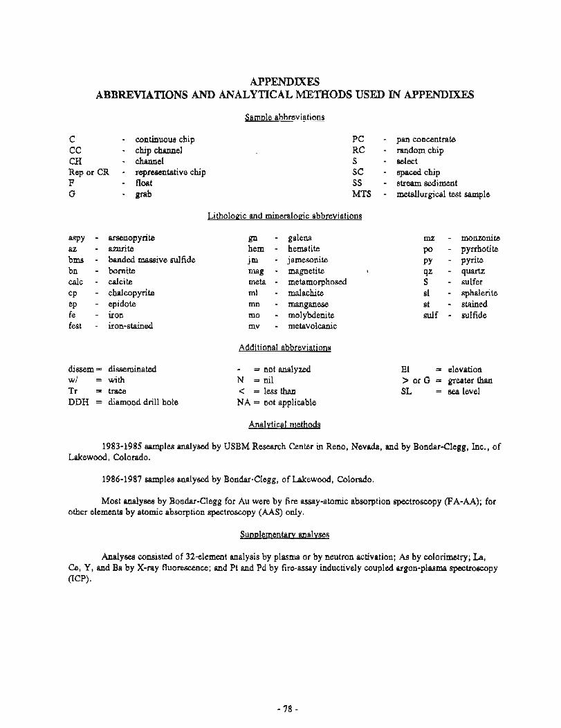
APPENDIXES ABBREVIATIONS AND ANALYTICAL METHODS USED IN APPENDIXES
Sample abbreviations
C - continuous chip CC - chip channel CH - channel Rep or CR - repmmtative chip F - float G - ~ r a b
- arsenopyrite - azurite - banded massive sulfide - bornite - calcite - chalcopyrite - epidote - iron - iron-stained
dissem = disseminated w/ = with Tr = trace DDH = diamond drill hole
PC - pan concentrate RC - random chip S - select SC - Bpaced chip SS - stream sediment MTS - metallurgical test sample
Litholoeic and mineralortic abbreviations
gn hem j m
meta ml nln mo mv
- galena - hematite - jamesonite - magnetite t
- metamorphosed - malachite - manganese - molybdenite - metavolcanic
Additional abbreviations
- = not analyzed N = nil < = less than NA = not applicable
ILlZ - Po - PY - q= - S - sl - st - sulf -
monzonite pyrrhotite pyrite quartz sulfer sphalerite stained sulfide
El = elevation > or G = greater than SL = sea level
Analvtical methods
1983-1985 samples analysed by USBM Research Center in Reno, Nevada, and by Bondar-Clegg, Inc., of Lakewood, Colorado.
1986-1987 samples analysed by Bondar-Clegg, of Lakewood, Colorado.
Most analyses by Bondar-Clegg for Au were by fire assay-atomic absorption spectroscopy (FA-AA); for other elements by atomic absorption spectroscopy (AAS) only.
Analyses consisted of 324ement analysis by plasma or by neutron activation; As by colorimetry; La, Ce, Y, and Ba by X-ray fluorescence; and Pt and Pd by fire-assay inductively coupled argon-plasma spectroscopy (ICP).
APPFNDlX A . ANALYTICAL WTJLTS FMOM VOLCANIC-ASSOCIATED MASSIVE SULFIDE DEPOSITS IN PORCUPINE AREA
Aypendix Title P .. Page
Main deposit .1 ......................................... 80 Metallurgical tests on barite a a m p l ~ from the
Main deposit a d Mount Henry Clay prospect ................................................ 82
Mount Henry Clay prospect ........................... 89 Hmgiug Glacier prospect ............................ 91 Cap prospect ........................... ... ............ 92 Numa prospect ........................................ 93
.......................... Little Jarvis Glacier prospect 94 ....................... Jluvis Glacier Gulches prospect 95
Metallurgical test results from Windy Cragqy ........................................... deposit core 97
Appendix A-1. Analytical results, Main deposit (map nos. onfigs. 2-3)
Fie assay
Sample size Sample AU Ag
Atomic.absorption X- my Spectrographic @pm unless marked %) ( P P ~
Cu Pb Zn Co Ba W Mo S n As Ni (a)
Lithology, remarks
p i l l o w metabasalt greenschist u / d i s s m gn b a r i t e u/sl,gn metabasal t b a r i t e a t contact u/metabasalt b a r i t e zone u/gn,sl b a r i t e zone u/gn,sl b a r i t e zone u/gn,sl b a r i t e zone w/gn,sl b a r i t e gossan zone b a r i t e zone greenstone metabasal t b a r i t e w/sl,gn b a r i t e u/az,ml,gn greenstone black-gray f i n e grained rock banded b a r i t e u/gn,sl banded b a r i t e u/gn,sl banded b a r i t e u/gn,sl banded b a r i t e u/gn,sl laminated lmst a l te red p i l l o u basal t a l te red p i l l o w basal t i n schist a l te red p i l l o w basal t t o schist a l te red p i l l o w basal t t o schist sch is t u/reminant p i l l ows q z - s e r i c i t e sch is t w/ y ash w/sml l lens of cEert a l te red p i l t o u basal t qz-calc v e j n u/gn
9 z-calc ve in u/gn est b a r i t e zone
schis t white schistose t a l c and ye l low-st qz greenstone u/py qz-mica sch is t and greenstone C
white q z - s e r i c i t e schis t geoth i te cemented mica-schist conglomerate mica-schist /qz -ser i c i te schist w/ PY sandy b a r i t e s e r i c i t e a l t e r e d andesite w/py c h l o r i t e - s e r i c i t e schis t b a r i t e and gossan u/greenschist b a r i t e w/some s u l f barite,schist,gossan,qz qz-mica sch is t mete-andesite o r metabasalt f a u l t gouge meta-andesite o r metabasalt u / f a u l t gouge,gossan I
OD 0 I
- MTS - MTS 1.5 C 3.4 C 3.0 C
BOO 5300
Appendix A- 1. Analytical results, Main deposit-Continued
barite w/suld barite lens in greenstone,schist greenstone or schist barite u/dissem sl,cp,gn,py barite u/aissem si,cp,gn,py gosssn barite u/sl,cp,gn,py barite u/sl,cp,ni . greenstone rnassive barite banded barite barite gray schist altered rphyritic andesite met etmsaf? metabasal t mete-andesite pillow metabasalt
APPENDIX 2-A METALLURGICAL TESTS ON BARITE SAMPLES FROM THE MAIN DEPOSIT
AND MOUNT HENRY CLAY PROSPECT
Five samples were collected along the Windy Craggy structure in southeast Alaska during the 1983 field season, three from the Main deposit and two from the Mount Henry Clay prospect. The samples were p r d at the USBM Albany Re-search Center (ALRC). The USBM Alaska Field Operations Center (AFOC) and ALRC sample identification numbers are:
AFOC ALRC
Main deposit 3s 112 ME 1536 3S118 ME 1537 38258 ME 1538
Mount Henry Clay prospect 383238 ME 1539 3S323B ME 1540
Mineraloeical Characteristics I
Main deposit
Samle 3S112 M E 15361. This sample is a white, porous, coarsely crystalline, sugary-textured, considerably dissolved-leached (weathered) friable barite. About 20 percent of the barite and other minerals once contained have been dissolved away. Very minor random iron-oxide stain is present. No sulfide minerals were observed.
Samle 3Sll8 IME 15371. This sample is a variably weathered and altered, sugary-textured, equigranular massive barite containing random dark bands of mixed sulfide minerals and magnetite representing about 20 percent of the sample. Most of the bands are thin and discontinuous, but in some areas they are an inch or more thick. The thick bands contain barite mixed with variable amounts of galena and magnetite with minor pyrite, sphalerite, and covellite. Where the specimens show weathering and alteration, some of the barite and all of the sulfide minerals have been altered and leached away, resulting in considerable porosity and leaving crystal molds and scattered magnetite grains. Some of the porous areas contain considerable anglesite and at least two unidentified secondary copper-bearing minerals, one of which may be tenasite (Cu, Zn)5(SQ4b(0H)6.6H20). In the altered areas limonite emphasizes the layering.
Polished surface and SEM examinations of areas selected for high sulfide content (for example, the dark thick bands) show that in addition to the galena, magnetite, and covellite, a fair amount of very fine grained anglesite is present, filling cracks in the barite and closely associated with the covellite. Approximate amounts of each mineral over several areas are as follows: barite 45 percent, galena 20 percent, magnetite 15 percent, anglesite 10 percent, and covellite 10 percent.
Considerable liberation of the sample. minerals would be accomplished at 65 m h ; 100 mesh provides more complete liberation with minor locking to finer sizes.
Samule 35258 (ME 1538). This sample is a rmgary-texhued, equigranular, massive banded-bedded barite. The banks are generally dark and contain concentrations of honeycolored sphalerite with variable pyrite and small amounts of bomite and galena. The grain size of the sulfide minerals ranges down from about that of the barite to much finer sizes. Some of the exposed surfaces and fracture surfaces are iron oxide stained. Thin layers of muscovite-sericite occur on some fractures parallel to the apparent bedding. A few random solution channels are dso present.
Polished-surface, SEM, and SEM-EDAX examinations show that, in addition to the minerals mentioned above, the sample contains variable amounts of celsian, covellite, and temantite. The celsian contains only
0.9 percent K. The teanantite is a ziYlcian variety with the following analyses: 42.3 percent copper, 8.6 percent zinc, 14.2 pernent arsenic, 6 percent antimony, and 28.9 percent d f b u . .
Appn~ximate amounts s f each mineral over several areas is as follows: barite 54 prcent, celsian 15 percent, sphalerite 10 percent, pyrite 10 percent, bornite 5 percent, covellite 3 percent, galena 2 percent, and tennantite 1 percent.
Practical liberation of the mined components would be at about 100 m h . Some locking would be evident evea at her sizes.
Mount Henry Clay prospect
Samle 3SY23A CME 8539). This sample is a medium- to finegrained, mgary- textured, equigranular, bedded mixture of light-yellow to dark-brown qhalefite associated with pyrite and barite with some scattered chalcopyrite aid small veins of calcite. The bedding is not selective, and layers contain variable amounts of barite and the sulfide minerals. A few random veins or fracture fillings of mixed pyrite and chlorite were noted. Variable amounts of iron-oxide minerals are present on fracture surfaces. Dewsition appearr; nearly contemporaneous.
Polished-surface, SEM, and SEM-EDAX examinations show that nlinor amounts of quartz and galena are present in addition to the abovementioned minerals. The matrix appears to 1% sphalerib and there are no intercrystalline intergrowths of sulfide in one another or i~ the barite crystals. Chalcopyrite is the finest grained on average; there is wme very fine grained pyrite present. The large pyrite crystals show considerable fmturing. Approximate mounts of each mineral over several areas is as follows: sphalerite 47 percent, pyrite 25 ppercent, barite 15 percent, chalcopyrite 5 percent, calcite 5 percent, quartz 2 percent, and galena 1 percent.
Good libenrtion rshould be achieved at 65 mesh with better liberation through 100 mesh.
Sam~le 3S323B W E 15401, This sample is a massive, large to medium crystalIine gray to white barite containing variably abundant small l m , veins, and smears of very h e grained chlorite with accompanying small eulie8t.al to subhedral crystals of magnetite. Some small magnetite crystals are scattered in the barite. A trace of pyrite is also present. No other sulfides were observed. Minor iron oxide minerals are present.
SEM micrographs and element display maps are filed with the original of this report and are available for reference.
Beneficiation Characterization
Head analysis of the ~luzrples are shown in table A2-1. Zinc analyses ranged from 0.01 to 21.2 p e n a t ; copper nmged from 0.01 to 1.15 p e a t ; cobalt and gold were negligible; and significant silver values (about 1 ozlton) were found in time of the samples.
Sample 3S112 (ME 1536) from the Main deposit and sample 3S323B (ME 1540) from the Mount Hemy Clay prospect are high-grade burite. The 1979 Mineral C o d i t y Profile on barite gives specifications for barite accordiug to its different uses. These are:
1. Weighing mud: .90 to 95 percent minus 325 mesh .specific gravity of 4.2 or higher .free of soluble d t s .low prceiitage of iron oxide.
2. Qieraid mauufacturing: .minimum 94 percent Bas04 .maximum 1 percent F9O3 .maximum 1 percent SrS04
.trace F
.size range of 4 to 20 mesh.
3. Glass manufactwing: .minimum 95 percent BaS04 .maximum 2.5 percent SiO;? .maximum 0.15 percent Fe203 .preferred size range of 30 to 140 mesh.
Tables A2-2 and A2-3 show the results of sizing samples 3S112 and 3S323B on 28 and 150 mesh and comparing analyses with the above specifications. Only the minus 150 mesh fractures, ground to minus 325 mesh and lached in water, exceeded specifications. The other size fractions very nearly met specifications, and additional tests would be necessary to determine whether they could be sufficiently upgraded.
Tables A 2 4 to A2-7 show the results of flotation studies on samples 3S118 (ME 1537, 3S258 (ME 1538), and 3S323A (ME 1539). The objective was selective flotation to produce a barite product and a sulfide product.
Tables ,424, A26, and A2-7 describe methods in which Cuso4 was u$sd as an activator for sphalerite prior to sulfide flotation with a xanthate collector and silica flotation with an amine collector. Barite remained in the nonfloat tailings. Recovery of zinc in the sulfide prducts ranged frum 87 percent to 99 percent, and recovery of Ba in the nonfloat barite products ranged from 89 percent to 90 percent. The specific gravity of the barite product was 4.3 glcc in two of the tests and 3.7 glcc in the other.
Table A2-5 describes a study on sample 38258 (ME 1538) in which sulfides were floated with CuSO4 and a xanthate collector, and then barite was floated with Na20.Si02 and a petroleum sulfonate-type promoter. Recovery of zinc was 98 percent in the sulfide float product and Ba recovery was 94 percent in the two barite float products.
The results reported here ae the best to date, but they should not be regarded as the best obtainable. No attempts have been made to optimize conditions, reagent selection, or reagent addition.
Size f r a c t i o n
Plus 28 mesh Chemical-grade ba r i t e
speci f icat ions
28 by 150 mesh Ci!ess-grede b r i t e
speci f icat ions
Minus 150 mesh, ground2to minus 325 mesh and Leached
Weighting mud ba r i t e speci f icat ions
Analysis Tota l 1 Specif ic
re 2 3 , I re SrSOL 1 F SiOz l g rav i t y (g/ccj I I I 1
0.56 1 0.48 1 1-43 1 0.71 4 . 3
L1.00 L 1 . 0 0 I t r a c e 1 I 0.50 0.49 1 2.82 1 4-4
I I I L0.15 j I L2.50 I
I
1 4 -6 I I
a Average value calculated from the Ba and SO analyses.
4 - L
Tepvater Leech, 5OSC, 5 hour, 5% p?!p density, a g i t e t i ~ . Hasnetice (C.2Yn: co!iec:ed on the inagne:ic s t i r r i w bi 6rd uss removed before chemicai anaiysis. n 0 - solubte weight loss of 0.4%. 2
Table A2-4. Results ofmtation of sample 3S148 (ME1537)from the Main dtposir Metal lurg ica l r esu l t s
tuso ~ o t a 4 s i u n amylxanthate Frother 0.05 Lb/st
Tes
Amine Promoter I pH (natura l = 5.8) 1 5.8
D is t r ibu t ion . /Yo) Ba I S 0 4 ! Pb I Zn ( S i O
I 2
2.2
90.2 90.0 55.5 11.0 96.2 100.0 100.0 100.0 100.0 100.0
-
Product (Weight Analysis CO/o) !('lo) { Ba ( S O I Pb 1 Zn Si0 1 1 4 1 1 I 2
PD s u i f i d e f i o a t I 10.1 31.2 '22.4 ' 15.0 11z.4 I L(1.05 Zn s u l f i d e f l o a t 1 2.8 / 2 126.5 / 14.4 2.90
Reagents
Time (minutes) I l l 4
8.40 6.10 5.40 6.30
S i l i c a f l o a t 1.5 39.0 26.2 9.7 I
Condition
1 Specif ic g rav i t y 4.3 g/cc
Bar i te t a i l i n g s Conps i te or t o t a l Head
Pb s u l f i d e $ loat
procedure Condition I Condit ion
1
85.6 100.0
ZnSulfide . f loat
51.5 48.9 48.4
Condition
35.8 34.0 34.4
S i l i c a f l o a t
3.0 4.6 5.0
0.2 1.6 1.6
Table A2-5. Results ofpotation of sample 3S112 @I.!? 1536)fiom the Main deposit
Metal lurq ica l Cesults Product (weight 1 Analysis &/o) l ~ i s t r i b u t i o n (%I I C0/0) 1 Ba I SO4 I Zn I Ba I SO I Zn
I 1 4 1
Sul f ide f l o a t I 18.0 Bar i te f l o a t 1 Bar i te f l o a t I I Tai l ings Composite o r t o t a l Head
Table A2-6. Rcsuks offtotation of sample 3S258 (ME 1538)from the Main deposit
Meta l lu rg ica l r e s u l t s Product (weight 1 Analysis iOlo) I Distr ibut ion,[%\
I (O1-1 Ba I SO4 ( Zn SiO I Ba I I 2 I I s04 I I I 2 Sio
Reagents
CuSO Potatsiun amylxanthate Frother Na O.SiO pegrole& suldonate g r a t e r pH (natural = 6.2) Time (minutes)
19-4 1 1 7 . Sul f ide Head f l o a t 1 7 - 7 S i l i c a f l o a t I ( 2.1 34.4 24.4 S i l i c a f l o a t I l l 1 1.5 28.2 19.6 Bar i te t a i l i n g s 77.0 53.8 37.4 Composite o r t o t a l 100.0 45.9 31.1
43.4 31.1
Condit ion
2 l b /s t 9.2
2
Condition
0.5 Ib /s t
5 -9 10
Bar i te f l o a t I
3
Test procedure
1 Speci f ic g r a v i t y 4.3 g/cc
- - Condit ion
0.1 Lb/st 0.05 l b /s t
6.2 1
CuSO Pota$siun amylxanthate Frother Amine Promoter
C o d i t i o n
1 lb /s t 8.9
2
Reagents
0.5 l b / s t 0.1 l b / s t
i 0.05 Lb/st
0.1 lb /s t 0.01 Ib /s t
B a r i t e + loa t 1 1
3
- - - - - - - - . -
Condition
pH (natura l = 5.9) 5 -9 1 6.4 6.6 Time (minutes) l 3
Sul f ide f loa t
I
Condition S i l i c a f l o a t I 1
Condition
I I I I I
I I
I I 4 lb /s t
I 1 9.3
4 l 2
Condit ion Su l f i de f l o a t 1
Su l f i de + loat
Condition
Table. A2-7. Rcrrrlrs offlotation of s m p b 3S423A (ME 1539)from the Mount Henry Clay prospea
Heta l lu rq ica l r e s u l t s Product IUeight Analysis C"lol 1 D is t r ibu t ion Lolo)
B a r i t e t a i l i n g s
1 11.3 7.3 21.2 5 . 4 I
Test procedure Reagents
CuSO potaksiun amylxanthate Frother
Condition S i l i c a +!oat
Sulf ide I Condition
2
Arnine Promoter pH (natura l = 5.9) T i m e [minutes)
1 Speci f ic g rav i ty 3.7 g/cc
I I
0.1 Lb/st 0.05 Lb/st
1 lb /s t 0.1 tb/st 0.05 lb /s t
6.6 90
6.7 1 7.2 1 1 1

Table A2-1. H e d analysts
AFOC No. I ME No. ( Pt I Pd I A u 1 Ag
Table A2-2. Analysis of sizcdfmaions of sample 3SI12 (ME 1536)from the Main deposit
Sample
2 10% acid, 3.5 hour, 25% pulp density, agi tat ion.
Locat ion
MainDeposit MainDeposit HainDeposit M t - H e n r y C l a y Mt. Henry Clay
AFOC No.
3S112 3S118 3S258 3S323A 3S3238
3 Tap-uater leach, 50°C, 5 h w r , 5% p l l p density, agi tat ion. H 0 - soluble weight loss of 0.4%.
2
HE No.
1536 1537 1538 1539 1540
Ana l ys i s Lofib
Ba
56.5 48.4 43.4 11.9 54.3
Pb
0.08 4.98 0.53 0.17
10.02
SO 4
39.0 34.4 31.1
7.3 38.2
S
14.3 13.4 17.5 32.0 14.1
I Co
L0.005 L0.005 Le.005 0.005
10.005
Ca
0.07 0.41 0.44 1.58 0.86
SiO 2
1.54 6.27 4.44 5.40 3.81
C u
0.01 0.24 0.87 1.15 0.01
Fe 0 2 3
0.64 0.41 4.19
18.80 0.63
Sr
0.10 0.09 0.06 0.04 0.42
Total Fe
0.48 1.51 4.17
14.60 0 - 5 9
Zn
LO.01 1.56 4.64
21.20 LO.01
A p p d i x A-3. Analytical nsuksfrom Mount Henry Ckty prosped (map nos. onfigs. 4, 6-7)
Fire assay Atomic absorption X- ray Spectrographic
Sample (ppmn unless marked 46) @ ~ m p size Sample AU Ag Cu Bb Zn CO Ba W MO Sn As Ni Bi Lithology, remadcs
i f o l i a t e d d i o r i t e b a r i t e u/sparse s u l f b a r i t e u/cp,p ,sl b a r i t e u/cP,sY
f e l s i t e s u l f boulder u/ barite,cp,sl
z - b a r ~ t e w/po,sl,gn ? e l s i t e su t f boulder u/ barite,cp,sl c h t o r i t i c p h y l I i t e u/sl,cp c h l o r i t i c p h y l l i t e u/ az,sl.cp,py f e s t greenschist a l te red t u f f u/mag,sulf a r g i l l i t e u /su l f metabasalt aqglomerate s t l iceous t u f f shale fes t mta-andesi te f e s t mete-andesite u/ 0.05 f t py bands greenqchist qz ve in shale s e r i c i t e p h y l i i t e w/py b a r i t e u/sl,gn,py qz-calc ve in i n p h y l l i t e w/cp banded b a r i t e u/s i ,gn f e s t sch is t u/py muscovite schis t u/barite,py qz and p i ryk i i te p h y l l i t e u/mag
muscovite p h y l l i t e u/py
b a r i t e u/cp,sl s i i i c i f i e d t u f i u/mi,cp bms u/barite,sl,gn,py c h l o r i t i c p h y l l i t e u/ 0.05 f t band of c m l same boulder as a k v e u/py,cp c py,qz-calc band c R ~ o r l t l c y r r i e e u/py,mag b a r i t e bou ?' der u/sl,cp,gn,py greenstone u/py h s U/CP.PY e
c h l o r i t i c phy l l i t e u/py o. Y) massive py w/cp,calc . mete-aridesite t u f f w/pY bms w/barite,sl.gn.cp,p~ tms u/barite,sl,cp,py a l t e r e d s i l i c i f ~ e d andesite U/
PY
Appendix A-3. Analytical resultsfiom Mount Henry Clay prospea-Continued
N bar i te boulder u/sl,gn N banded ba r i t e u/sl,cp,gn N altered t u f f u/py N bms w/barite,sl,gn,py N banded bar i te u/sl.cp,gn N c h l o r i t i c p h y l l i t e u/
bar i te s1,cp N bms u/barite,sl,py,cp N calc boulder u/bartte,cp,sl N bms w/barite,sl,cp,gn,py N bms u/barite,sl,cp.py N bms w/barite,sl,cp,py N cf: Lens-in qz-calc vein N c l o r i t r c p h y l l i t e u/hem N bms u/barite,sl,py,cp N tmts u/barite,sl,py,cp N bms u/barite,sl,py,cp N bar i te N massive cp,sl boulder N bmsw/barite N bar i te bwlder N bms u/barite,sl cp,py
3000 bms bwlder u/s i ,cp 4000 uhite-grey schist
N bms w[barite,sl,cp M tans u/barite,sl,py,cp N bms u/barite,sl,py,gn,cp N bms u/barite,sl cp N bar i te-calc boulder u/cp,py,ml N ch lor i t i c phy l l i t e u/py,mag N c h l o r i t i c p h y l l i t e u/py N c h l o r i t i c p h y l l i t e w/
barite,cp,py,ml N - a l tered t u f f w/cp,sl,ml N ba r i t e boulder u/py N s i l i c i f i e d t u f f u/cp N c h l o r i t i c p h y l l i t e u/
qz bands,c s l N bar i t e boufher u/cp,mag N c h l o r i t i c y l l i t e u/&g N bar i t e boucer u/s l .cp N banded-barite u/sl,cp,ml,mg N qz-barite u/cp,ml
- c h l o r i t i c p h y l l i t e u/qz,py,cp - bar i te N qz-barite vein
2000 massive meta-andesite N three bar i te veins 0.3 f t thick N calc,qz,barite lens u/cp,ml N c h l o r i t i c p h y l l i t e u/py N qz-barite u/greenschist - c h l o r i t i c p h y l l i t e
2000 meta-andesite 2000 fest greenschist
N fest se r i c i t e schist u/py N qz-calc vein
1000 mete-andesite N fest s late N greenstone,meta-andesite
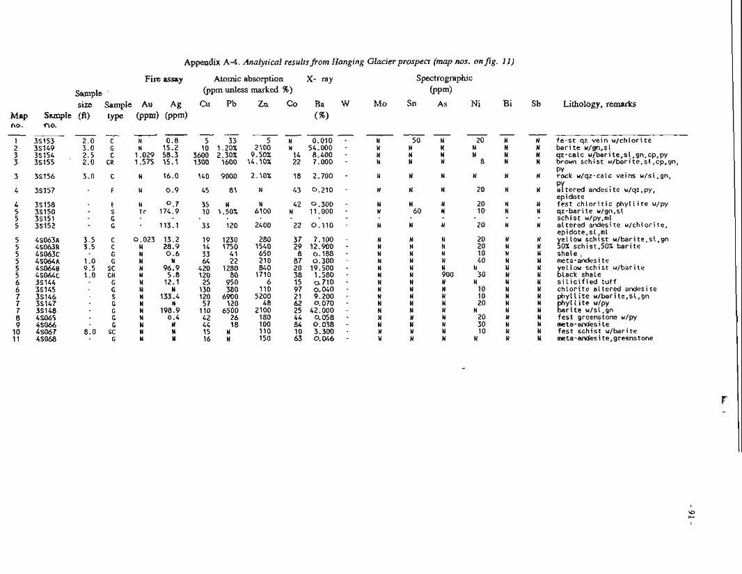
Appe~dix R-4. Ar;a!ytjiti'cal resul;sj"rorn Hanging Glacier prospea (map nos. on fig. I d )
Fire assay Atomic absorption X- ray Spectrographk
Sample ' (ppm unless marked %) ( P P ~ )
size Sample Au Ag Pk, Zc Co Ba W M o Sn As Ni Bi Sb Map S a w 1 6 (ft) type @pm) no. no.
Lithology, remarks
Fe-st qz vein %/chlorite barite u/gn,sl qz-calc u/barite,sl,gn,cp,py brown schist r?/berite,sl,cp,gn, PY rock u/qz-calc veins u/sl,gn,
irtered andesi te w/qz ,py, epidote fest chloritic phyllite u/py qz-barite r/gn,sE schist u/py,ml altered andesite u/chlorite, epidote,sl,ml
J ellou sch~st u/barite,sl,gn OX schist.50X barite shale rneta-andesite
i ellou schist u/barite Lack shale silicified tuff chlorite altered andesite phyllite u/barite,sl,gn e yll~te u/py rite u/sl,gn fest greenstone u/py meta-andesite fest schist u/barite meta-andesite,greenstone
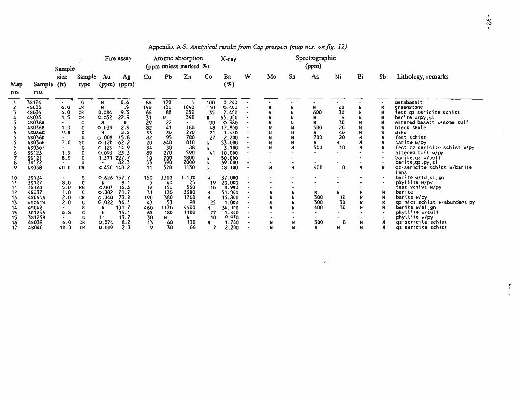
Fire assny
Sample size Sample Au Ag
Sample (fi) type @pm) @pm) no.
(I-
N 0.6
Appendix A-5. Analytical resultsfrom Cap prospect (map nos. on&. 12)
Atomic absorption X-ray Spectrographic @pm unless marked 96) @ ~ m )
63u Pb Zn Co Ba W Mo Sn As Ni ( 5 )
Lithology, rcmarks
mtabasal t greenstone fes t qz s e r i c i t e sch is t b a r i t e a l te red w/py,sl basal t u/some s u l f
black shale d ike fes t sch is t b a r i t e u/py fes t qz s e r i c i t e sch is t w/py a l te red t u f f u/py barite,qz u/suLf barite,q?,py,sL q z - s e r l c l t e sch is t u /bar i te Lens b a r i t e u/td,sL,gn phylls i t e u/py fes t sch is t u/py b a r i t e b a r i t e u/p qz-mica s c l i s t u/atundant py b a r i t e u/sl,gn p h y l l i t e p h y l l i t e u /su l f w/py
q z - s e r i c i t e sch is t q z - s e r i c i t e sch is t
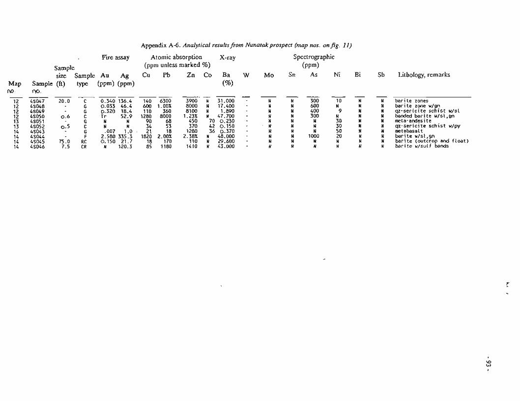
Fue assay
size Sample Au Ag M2p Szqp!e (fr) type (ppm) (ppm) no w. ------
12 45047 20.0 C 0.340 136.4 12 45048 G 0 . 0 3 3 4 6 . 4 12 4SO49 G 0.320 18.4 12 4S050 0 . 6 c Tr 52.9 13 45051 G N N 13 45052 0 . 5 C N N 14 45043 G -007 1.0 14 4S044 F 2 .580335 .3 14 4S045 75.0 RC 0 . 1 5 0 2 1 . 7 14 4S046 7.5 CR N 120.3
Appendix A d . Anolyrica6 resulrsfiorn Nunarakprospect (map nos. on fig. 11)
Atomic absorption X-ray (ppm unless marked %)
Spectrographic ( P P ~ )
Lithology, remarks
bar i te zenes bar i te zone u/gn qz-ser ic i te schist u/sl kded & r i t e r/s!,gr? mete-endesite qz-ser ic i te schist u/py metebass! t barite u/sl ,gn bar i te (outcro and f l o a t ) k r i te r/sul f Lds
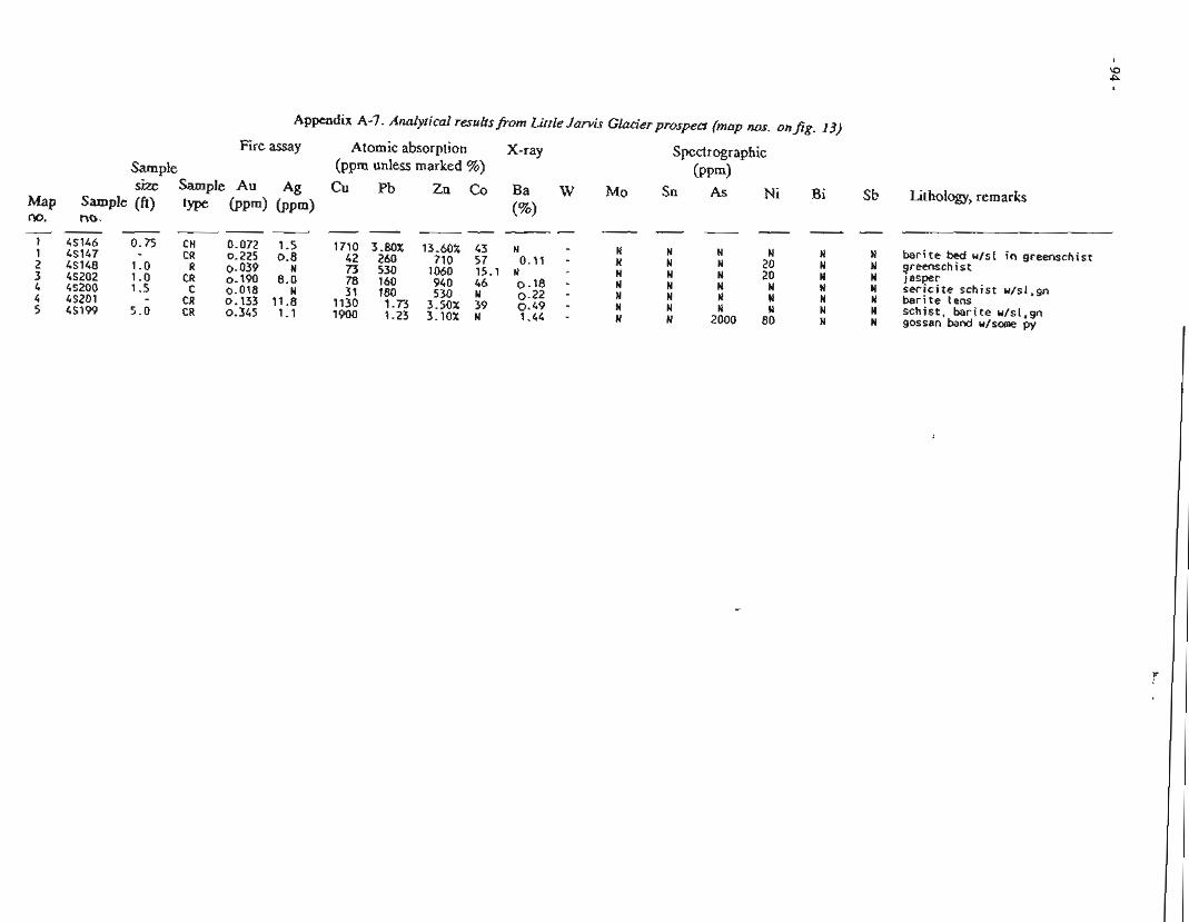
Appendix A-7. Analyfical resultsfi-om Little Jamis Glacier prospea (map nos. on fig. 63)
Fire assay
Sample size Sample AU Ag
Sample (ft) type ( P P ~ ( P P ~ ) no. - - ---
4S146 0.75 CH 0.072 1.5 4S147 CR 0.225 0.8 45148 1.0 R 0.039 N 4S202 1.0 CR 0.190 8.0 45200 1.5 C 0.018 N 45201 - CR 0.133 11.8 45199 5.0 CR 0.345 1.1
Atomic absorption X-ray (ppm unless marked %)
Spectrographic ( P P ~ )
Sn As Ni St! Lithology, remarks
barite bed u/sl in greenschist greenschist Jasper serlclte schist u/sl,gn barite lens schist, barite u/sl,gn gossan band w/some py
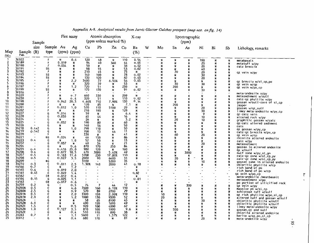
Appendix A-8. Analyrical resulfs~krn Jarvis Glacier Gulches prospect (map ms- on fig. 14)
Fire assay Atomic absorption X-ray (ppm unless marked %)
Cu Pb Zn Co Ba WI -----
120 48 N 110 0.54 94 40 360 44 0.05 50 N N 38 0.02 08 55 N 53 0.02
210 45 N 73 M 140 100 N 78 0.02 130 120 N 82 0.03
3400 77 6.50% 56 0.03 320 39 N 53 N 720 51 N 230 N 170 170 N 91 0.02
660 330 N 200 N 320 51 N 110 0 -02
4.60% 710 7.90% 130 0.14 120 85 N 7.1 N 520 110 5100 20 N 210 190 19 120 N
59 1 N 6.4 N 65 44 N 16 N 26 N N 3.2 N
190 80 N 60 N 140 56 N 50 N 790 110 N 50 N 700 13 46 11 N 330 N N 41 N
46 130 N 86 N 52 50 N 13 N 40 34 N 21 N
870 170 250 84 N 980 120 N 160 N 470 3000 5.40% 49 N
5700 230 17.80% 110 N 2000 90 6400 31 N 3100 - 5200 35 - 1.30% 140 2000 41 0.18
w N
- 0.02 N - 0.01
Spectrographic ( P F ~ )
Sn As Ni Sample size Sample Lithology, remarks
Sample (ft) type M.
metabasal m2*.... c c t CPLJI I Y!PY
ca lc breccia
qz ve in u/py
qz breccia w/sl,cp,po qz ve in u/cp qz ve in u/po,cp
meta-andesite u/p metasediment u/scarf calc-qz p h y l l i t e w/py gossan u /su l f - co re of s1,cp jasper Scssan w/qz,sulf l i m y meta-andesite u/py,cp qz-calc ve in s l tered rock u/py g raph i t i c gossan w/calc qz-calc a l te red sediment ca lc qz gossan u/py,cp calc-qz brecc ia u/po,cp qz vein u/cp c h l o r i t e a l te red andesite ce lc u/py wtased~ment gossan in a l te red andesite qz u /su l f su!f zone u/py, s l ,gn calc-qz zone u/sl,cp,py calc-qz zone u/sl,cp,py gossan zone i n a l te red andesite c h l o r i t i c p h y l l i t e u/cp r i c h barid o f po r i c h hand o f po u/cp
qz ve in u/po,cp meta-andesite /meatbasalt metasediment u/po po por t ion of s i l i c i f i e d rock qz ve in u/py massive po u/sl,cp schistose t u f f u /su l f qz r i c h p h y l l i t e u/po,sl,cp a l te red t u f f and gossan u/su l f c h l o r j t i c p h y l l i t e u /su l f c h l o r r t i c p h y l l i t e w/sulf t i m y meta-andesite u/py gossan,qz and s u l f c h l o r i t e a l te red andesite b a r i t e u/qz,po,sl,cp mete-andesite u/py
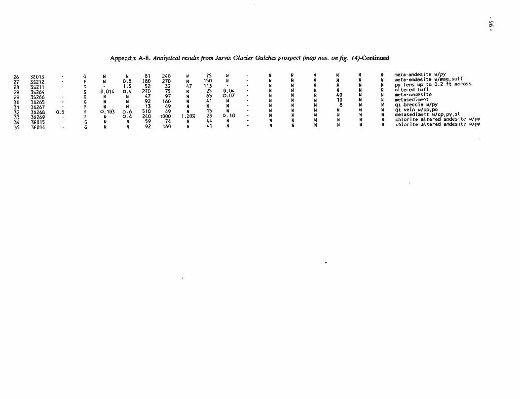
Appendix A-8. Analytical resuhsfrom Jantis Glacier Gulchesprospect (map nos. onfig. 14)-Continued
meta-andesite u/py mete-andesite w/mag.sulf p lens up to 0.2 ft across artered tuff meta-andesite metasediment qz breccia u/py qz vein w/cp,po metasediment u/cp,py,sl chlorite altered andesjte u/py chlorite altered andesite n/py
Appendix A-9. MetallltrgicaI rest r.csultsj?om Windy Craggy deposit core
The Windy Craggy deposit is located in Canada along the same geologic trend that contains the Main deposit and Mount Henry Clay prospect. It contains 300 nlillion tons of material averaging 1.52 percent copper and 0.08 percent cobalt. During 1982 a test sample was collected from the Windy Craggy deposit diamond-drill cores and supplied to ALRC for testing. The AFOC sample number is 2341'7 and the ALRC numbers are ME 1463 and PS 1651.
Mineralopical Characterization
The sample, as received, was crushed to minus 0.5 inches and represents a massive-sulfide deposit consisting essentially of pynhotite with small to very small amounts of randomly dispersed pyrite, chalcopyrite, quxtz, siderite, ferronlagnuian silicate minerals, chlorite, and iron-oxide minerals as inclusions and small veins.
Polished-surface, SEM, SBM-EDAX, and microprobe examinations show that the scattered pyrite is partly and variably cobaltiferous, varying from grain to grain and within grains. It appears to be sulfur deficient with the deficiency apparently related to the cobalt content. It also appears to be zpned relative to the cobalt content which averages about 2 percent and ranges from 0.1 to 5 percent cobalt. The pyrite ranges in size from less than 10 to about 100 micrometers, with an average of 20 to 3Q micrometers. There is a tendency for the pyrite to be agglomerated and some mounted fragments showed up to 15 percent pyrite while others contained very little pyrite. Pyrrhotite contains from 0.13 to 0.33 percent cobalt. 'The chalcopyrite content is less than that of the pyrite. It is associated both with the pyrite and as separate small crystals included in pyrrhotite. Grain sizes are similar to those of the pyrite. No precious metal-containing minerals were observed.
As will be seen in the following beneficiation results, the minerals are not liberated from each other at any practical size and no concentration of metals of any consequence was produced.
Beneficiation Characterization
After petrographic specimens were selected, the rest to the sample was crushed to minus 0.25 inch and split for head analysis and beneficiation tests. The head sample contained 0.46 percent copper, 0.01 percent nickel, 0.21 percent cobalt, 55.3 percent iron, 0.03 percent zinc, 0.02 percent arsenic, 35.1 percent sulfur, < 0.01 oztton platinum, e0 .02 ozlton palladium, C0.0004 oz/ton gold, and C0.01 ozlton silver. Precious metals analyses were done at Reno Research Center; the other analyses were done at AI-RC.
A series of tests were done on 1-kg splits to try to selectively concentrate the copper and cobalt values. Table A9-1 contains the results. Sizing, selective flotation, and magnetic separation were tried with little success. Copper was concentrated by flotation with recoveries up to 90 percent, but the grade was low (generally 1 to 2 percent copper). Cobalt concentration was not successful: grades of concentrates that were produced by flotation or magnetic separation were essentially the same as that of the herid, and consequently recoveries were nearly the same as the weight distributions in a test (no concentration).
As stated earlier, SEM and microprobe data show that cobalt is concentrated in pyrite in solid solution. However, it also occurs in pyrrhotite, and because pyrrhotite is the predominant mineral, a pyrite-pymhotite separation would result in about 50 percent of the cobalt reporting to each fraction.
The attached metallurgical balance shows the procedures and results of a flotation test in which a bulk sulfide flotation scheme produced a rougher concentrate and a scavenger concentrate that were combined and subjected to a selective cleaner flotation step in which pyrrhotite was depressed by KMN04. The cleaner conbentrate represented 45 percent of the sample weight and contained 84 percent of the copper at a grade of 0.95 percent copper and 55 percent of the cobalt at a grade of 0.23 percent cobalt.
Appendix A-9. Metallurgical test results from Windy Craggy deposit core-Continued
A cursory chlorite-oxygen leach on Windy Craggy complex sulfide, ALRC sample number ME-1463, was conducted at RRC. Analysis of the test products are shown in table A9-2. Table A9-3 shows the metals distribution. The chlorine-oxygen test was conducted at llO°C and 50 psig with 0 2 . The chlorine source was HC1 and CaC12. An excess of hydrochloric acid was used and oxidation of iron sulfide to sulfate resulted in 20 percent of the iron going into solution. With additional tests, good copper and cobalt extractions could be achieved without leaving iron in solution. Methods for recovering copper and cobalt from solution could be developed. However, in view of the low-grade nature of this ore, it is unlikely that any hydrometallurgical approach for recovering values from this ore would be economical.
Table A9- 1. Resulrs offlotation of sample 2S417 (ME 1463-9)fi-om the Windy Craggy deposit
Grind: I n i t i a l : -0.25 inch Final: +I00 mesh OX Time: 10+5 minutes Addition: none -409 sesk ? O C L Percent soiids: 50
-500 mesh 100%
Table A9-2. Analysis (%)
F i l t r a t e , g / l 2 . 3 0 . 8 0 5 . 1- 6 . 1 4 5 1 . 4
Wash, g / l 0.34 0 . 1 2 10 11 11 1 . 0
Res idue , X 0.024 0.028 L .001 4 3 . 3 1 4 . 8 1 7 . 0 2 . 7 9 5 . 0
Table A9-3. Distribution (96)
F i l t r a t e 4 6 . 5 4 0 . 8 G6 1 0 . 3 1 5 . 8 4 . 9 2 .2
Wash 4 9 . 1 4 3 . 7 8 7 10 .6 2 7 . 6 8 . 4 1 1 . 3
Residue 4 . 4 1 5 . 5 L7 7 9 . 1 5 6 . 6 86 .7 8 6 . 5

APPWDIX B . ANALYTICAL RESUI. TS FROM VEIN GOLD PROSPECTS IN PORCUPINE AREA
Appendix Title . Page
.................................. B- 1 Golden Eagle prospect 102 . .................................. 13-2 Annex No 1 prospect 104
.................................... B-3 Wolf Den prospect 1Q5 13 -4 Quartz Swarm prospect ................................. 106 13-5 Big Boulder Quartz Ledge prospect .................. 107
Appendix B-1 . Analytical resultsfrom Golden Eagle p rospea (map nos. 1 7-1 9)
F i e assay Sample size Sample Au Ag (fi) t) ( P P ~ ) ( P P ~ ) ----
3.0 CR N 0.2 6.0 CR 0.020 1.0 0.5 CC M N 0.5 CR N 0.5
G N 0.2 0 . 3 CC N 0.3 2.0 C N 0.5 0.1 CC 1.890 0.2 0.3 CC 4.240 0.6
- CR 0.005 0.5 0.2 CC 0.040 0.3
10.0 CR 0.005 0.4 10.0 CR 0.205 N 0 - 3 CC 36.620 2.6 5.0 CR 0.030 0.4 0.4 CC 22.220 1.3 3.0 CR 0.005 N 0.3 C t 0.090 0.2 0 .3 cc N N 0.3 5 18.580 1.0 1.4 CR 0.095 0.3 0.05 CR 0.065 0.2
CR 0.010 0.5 1.0 CC 0.020 0 . 2 9.0 CR 0.005 0.4 0.35 CC 0.245 0 .2 0.25 CH 182.130 17.1 0.35 G 1.501 N , 0.6 CR 0.010 N 1 0.6 CR 0.065 0.8 I 2.0 CR 0.010 0.2 0.7 CC 1.210 0 . 6 0.2 CC 0.435 3.4 7.0 CR 0.025 0 .5 2.0 CR 0.045 0.3
15.0 CR 0.175 0.7 2.0 CR 0.030 0.5 6.0 CR 0.005 0.7 0.35 CC 5.230 1.3 0.35 CC 18-860 3.5 1.0 C 0.170 0.3 0.5 R 0-015 0.8 0.05 R 0.030 0 . 6 5.0 R 0.055 0.4 0.1 R 4.590 1.5 0.1 G 2.474 0 .7 0.2 cc 0.025 0.4 0.1 . 5 2.650 2.6 5.0 C 0.095 0.5 2.0 CC 0.255 1.4 4.0 C 0.160 0.2 0.4 CC 4.660 Q4
- SS 0.031 N
Atomic absorption X-ray (ppm unless marked %)
Spectrographic ( P P ~ )
Sn As Ni Bi Sb Lithology, rcmarks Sample r\0.
55141 56142 55089 55090 5S091 55143 55144 58145 55146 55147 56148 55149 5W4 1 5w39 5W40 5W38 5W42 5w37 5W35 5W36
dike s la te u / s m py and qz qz-ankeri te v e i n s l a t e d ike qz ve in s la te qz ve in u/py g f k 2 i n U/PY
qz ve in u / s l s la te qz d ike ve in i n d ike u/py,sl
s l a t e j f k ~ i n u /su l f
qz ve in w/sulf qz ve in u /su l f i n d ike select o f 935
dike u/py s l a t e u/py s l a t e f a u l t gouge s la te and f a u l t gouge qz ve in u / l i n py c rys ta ls qz ve in u / l i n py c rys ta ls
z vein u / l i n py c rys ta ls a i ke s l a t e d ike qz ve in w/p sl ,cp select o f ~ { f s l a t e d ike u/py s l a t e w/py r i c h bands s l a t e s l a t e u/py qz ve in u/py
z ve in u/py 1- ike U / S U L ~
s l a t e u/ large py c rys ta ls s l a t e u/band o f py s l a t e u / t h i n bands of s u l f qz ve in u /su l f qz v e i n u /su l f vuggy qz ve in u / l a r e crysta ls s l a t e u/py,setect 07 9!?g s l a t e u/py
z ve in u/cp,sl l i k e "/rut t qz ve in w/sulf
dike u /s la te and s u l f f a u l t gouge o f d i ke and s la te qz ve in u/sl,py
Appendix B-1. Anaiyricai resullsfiorn Go& Eagb prospecl (map nos. 17-19)-Continued
p r i c h bands i n s l a t e Jete u/py qz ve in u/py s l a t e
z lens a t contact l i k e u/qz s t r ingers qz ve in qz ve in u/sutf qz ve in w/sulf qz w/aspy and creek sand qz w/sulf qz u/boxworks aspy and S S and aspy s l and S VUQ9Y 9 2 y u/py OX su f from back of vug
s l a t e d ike
9 z u/py,sL ,S est orange rock
s l a t e u/ fest qz s t r ingers s l a t e s l a t e u / w d ike qz ve in u/su l f select py In s la te j ~ ~ t ? i n u/lO% py
qz ve in w/30X py y ~ i n w/50% py
cemented s la te gravel 18 yds. u/coarse Au out
s l a t e f e l s ~ c d ike qz ve in i n f e l s i c d ike
d ike w/py q z ve in u/py s l a t e u/py slate-u/py qz ve!n qz ve!n qz ve!n
a! k 2 i 7 p y qz ve in s l a t e qz vejn
qz ve in 3fkens in d ike
? z-calc lens i n d ike est qz u/su l f
py r i c h bands in s l a t e
s l a t e w/sulf
Appendix B-2. Analytical resultsfrom Annex No. 1 prospect (map nos. onfig. 20)
Fire assay Atomic absorption X-ray Spectrographic Sample (pgm unless marked %) (PPm) size Sample Au Ag Cu Pb Zn Co Ba W Mo Sn As Ni Bi
Sample (ft) type ( P P ~ ) (PW) no.
(%) - - - - - -
Lithology, remarks
vuggy qz vein w/py dike u/py dike and qz.w/py vuggy qz vein slate brecciated u/py dike in fault zone
slate u/py vuggy qz vein u/py slate u/+20% py vuggy qz w/slate,py and S gossan 6 qz veins slate qz and dike w/sulf qz vein w/sulf qz vein u/sulf qz vein w/sulf
qz vein float u/sulf
Fire assay Atomic absorption. Spectrographic Sample (ppm unless marked 7%) ( P P ~ ) s:ze Smp!e An Ag Cu Pb Zn Co Ba Fh' Mo Sn As Pii
Map Sample (ft) trpe ( P P ~ ) ( P P ~ ) M. m-
C%) -- - - - I _ - _ . C_ - - - -
1 7W1733 0.3 CC 3.394 2.3 8 14 3550 1 -
- ~ r n - Sb Lithoiogy, remarks
z vein in dike u/aspy.py, ?=st ,gossan
4 z vein in dike w/aspy,py, est,gossan qz veln in dike u/15X py,aspy espy veinlet in dike w/gossan qz vein in dike w/15% py,aspy
slate w/py bands qz vein in dike w/sl,gn,py
Appendix B-4. Analytical results fiom Quartz Swarm prosped (map nos. on fig.
Fire assay Atomic absorption X-ray (ppm unless marked %)
CU Pb Zn CO Ba (%I -- - --
150 31 260 78 0.050 73 N 220 24 0.094 100 N 240 N 0.071 37 N 71 31 0.017 110 N 260 N 0.041
15 N 83 N 110 N 390 57 0.118 26 N 130 N 0.017 8 N 19 N 0.007 9 N 20 N 0.027 10 N 25 N N 7 N 76 N N 9 N 20 N 0.062 10 N 35 N 0.010 9 N 14 N 0.017 96 N 260 450.142 38 N 46 N N 33 3 44 10 - 9 1 7 128 35 - 30 9 30 6 - 67 16 96 29 - 38 5 48 9 - 33 14 40 12 - 26 9 43 18 -
Spectrographic ( P P ~ )
Sn As Ni Sample size Sample
Sample (ft) type r\l)r--
Lithology, remarks
d ike w/dissem po + sparse cp 3 z veins 50% of sarrple 402 q z q z ve jn s arse calc w/sulf q z veins 6.2 f t and 0.8 f t knot of po i r regu la r q z ve in fes t s l a t e q z ve in
q z ve jn w/calc q z ve!n q z ve!n If kF'n q z vein q z ve in u/5% calc metabasalt w/calc incluion q z ve in u/5% calc metabasalt q z se lect ve in q z w/5X u/mo calc
metabasat t q z ve ln metabasalt w/sulf q z ve in q z ve in metabasalt w/sulf q z ve in metebasalt qz veln q z ve in s l a t e w/some 0.05 f t qz str ingers q z ve in s l a t e qz ve in q z ve in w/calc s la te q z ve in s l a t e qz ve in q z ve in w/ y slate-wlsuf'f qz ve?n
9;sP:Clt e s l a t e w/sulf q z ve in s l a t e w/sulf q z ve in s l a t e oz ve in d ike banded s i l i c i f i e d rock
q z ve in s i l i c i f i e d and marblized sediments banded s i l i c i f i e d sediment w/po qz ve in u/po s i l i c i f i e d green sediment
Appendix B-5. Analytical resullsfrom Big Boulder Quartz Ledge prospect (map nos. onJg. 24)
Fire assay Sample size Smpie Au Ag
Sample (ft) ( P P ~ ( P P ~ ) no.
. -- -- 55313 1.0 C N 0.3 553 14 5.0 C N 1 . 1 5S315 8.0 CR 0.005 0 . 4 5S316 4 .0 CR N 1-8 5S317 2.0 CR N N 5H893 11.0 C N N 94894 10.0 C 0.005 N 5U890 10.0 C N N 5M892 10.0 C N N 5M891 10.0 C N N 5U852 6.0 C N N 5U853 4.5 C N N 5U854 5.7 C N N 5U855 1.0 C N M 5U856 1.5 C N Q.2 55050 13.0 SC N 0 . 2 5S051 4 . 0 SC N N 56052 4 . 0 C N W 55053 0.1 G N 0 - 2 55054 0 . 1 G N N
Not on map 20 dt above adit i n trench
55055 10.0 SC N - 3
Atomic absorption . X-ray (ppm unless marked %) Cu Pb Zn Co Ba
("/.I - - -
Lithology, remarks
%si te and qz vein f e l s i t e and qz vein f e l s i t e e rd qr vein
z end f e l s i t e vein ?e ls i te a d qz vein f e l s i t e end qz ve!n
z and f e l s i t e vein ?elsi te s d qz vein f e l s i t e and qz vein qz and f e l s i t e vein qz and f e l s i t e vejn qz and f e l s i t e veln
z vein Telsi t e fe!si t e
z vein fest some sulf ?est qz qz, f e l s i t e contect zone qz vein w/py
fest qz arid f e l s i t e
APPENDIX C. ANALYTICAL RESULTS FROM POLYME'TALLIC VEIN SILVEX PROSPECTS IN
PORCUPINE AREA
Appendix Title - Page
C-1 Lost Silver Ledge prospect.. ........................... 110 C-2 Memll's silver prospect.. .............................. 11 1 C-3 Glacier Creek prospect ........................... ..... 112
no- -
Appendix C-1. Analytical resultsfrorn Lost Silver Ledge prospect (map nos. on@gs. 25 and 26)
Fire assay Atomic absorption X-ray Sample (ppm unless marked %) size S a m p l e A u Ag Cu Pb Zn Co Ba W Mo Sn As Ni Bi Sb
Sample (ft) type ( P P ~ ( P P ~ ) M.
(%I - - U - - -- - - - -
Lithology, remark:
select qz-calc ve in u/jm,gn,ml z lmst sl,dike u/sul f
8 4 I e W / S U L ~ i m w / y e qz.py qz vein w/jm j m dolomite u/qz veins qz,slete,lmst and gossan 4 qz veins w/gn,sl qz ve in w/gn,sl,ml qz vein w/gn qz ve jn w/gn qz veln w/gn qz vein w/gn qz vein w/gn qz vein u/gn qz qz-calc ve in u/~m,sn,sl ve in u19n
est qz-calc ve in u/gn 11 qz veins u/gn,sl,cp,py gn FIGURE w/ml NO. -34
qz-calc ve in w/py qz-calc ve in u/py qz-calc ve in u/py qz-celc ve in w/py qz-calc ve in w/py qz-calc ve in w/py s l u/some qz qz vein w/sl py qz vein w/su[f qz ve in w/sl py qz vein w/su[f qz ve in u/gn,sl,py qz vein w/gn,sl,py
Appendix C-2. Analytical resulrsfiorn Merrill's Silver prospect (map nos. on fig. 28)
Elre assay Atomic absorption Sample (ppm unless marked %) size Sample AU Ag Cu Pb Zn Co
Map Sample Qft) type (ppm) ( P P ~ ) 'na. - --- - - - - - - -
1 5S371 5.0 SC E! ! .8 58 280 15?Q 40 1 5S378 - S 0.295 89.3 710 1.34% 13.00% 24 1 5 ~ 3 7 9 0.3 CR 0.025 8.3 169 765 5020 19 2 35237 0.1 CH 0.023 !.3 15 4!C! 1.91% H 2 3S238 0.2 CH N 0.6 16 410 1.02% N 3 35239 0 . 1 C 0.059 3.5 89 280 7700 M 4 3S235 0 . 5 CU 0.343 510.3 30 15.70% 5400 a! 4 35236 0 .4 G 0.471 22.2 170 5500 1.89"X 68 5 5 ~ 3 8 0 0 . 2 CR 0.035 97.7 26 1.95% 2240 1 5 5s381 0 . 5 C a175 129.9 I S 2.77% 2.42% M 5 55382 - G 0.005 4.3 6 760 700 N 5 3S240 0 . 1 C 0.010 253.7 24 3.90% 5700 N 6 3S241 - R M 0.8 K 190 6 3S242 0 . 2 R 96.0 1640 1.37%
X-ray
Lithology, remarks
qz-calc dike vein w/gn,green mica
qz vein w/p and sericite qz vein u/sr,gn,py,n~ argitlite qz-calc m/st ,py qz gassar. breccia u/gn argi l l i te u/sl ,gn qz-calc vein u/gn,sl z-calc veir: u/gn,sl
jolomi qz vein te w/gn,sl
qz u/suLf qz-catc breccia w/gn,sl
Appendix Cr?. Analytical resultsfi~rn Glacier Creek prospect (map nos. on fig. 29)
Fire assay Atomic absorption Sample (ppm unless marked %) size Sample Ag Ag Cu Pb Zn Co Ba W
Map Sample (It) type (ppm) (ppm) no. nob
(%)
- - - - I - - - - --- - --.- 1 3S028 S 0.590 3.0 550 140 130 11 - 2 8U1852 0.7 CH N 2.5 52 109 820 4 0.110 - 3 8U1853 0.5 CH 0.035 0.3 117 16 1100 4 N Not on ma 4 8Sl166 1.0 CR 0.007 1.3 126 12 325 11 0.370 -
Spectrographic ( P P ~ )
Mo Sn As Ni Bi Sb Lithology, remarks
------ - Lrnst u/py - Lmst u/sulf,dest - lmst u/sulf,fest
- fault zone in slate and Lmst w/ PY. f est
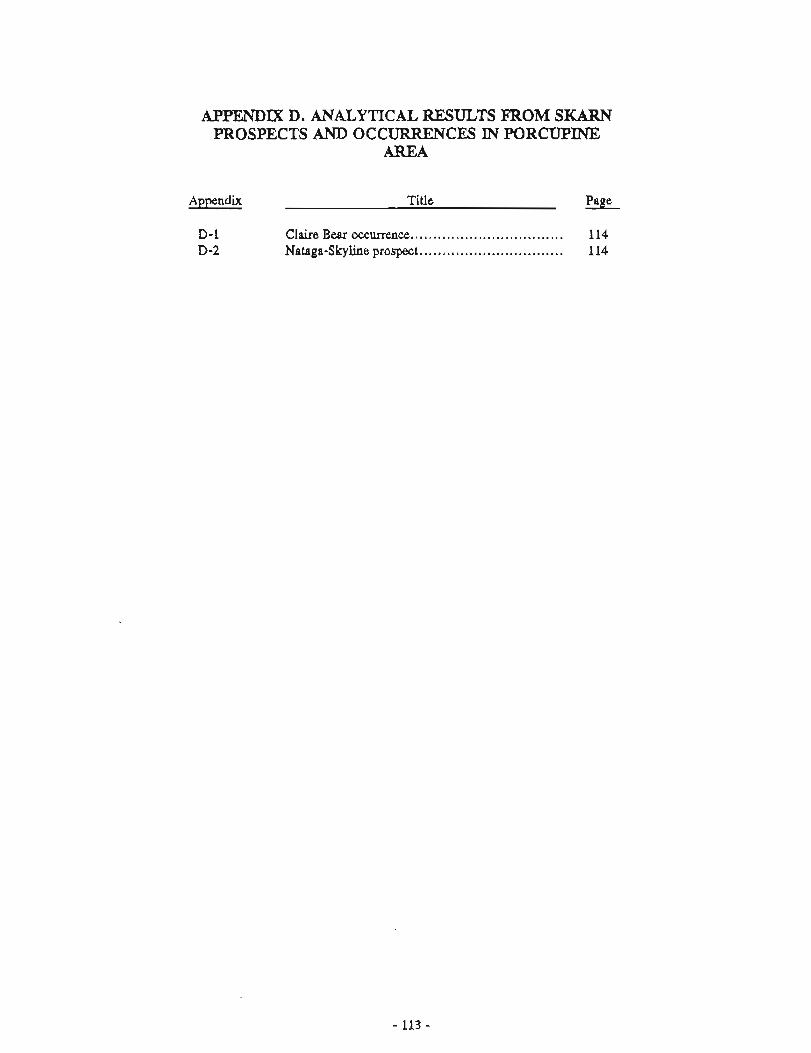
APPENDIX D. ANALYTICAL RESULTS FROM SKARN PROSPECTS AND OCCURRENCES IN PORCUPINE:
AREA
Appendix Title Paee
Claire Bear occurrence. ................................. 1 14 Nataga-Skyline prospect.. .............................. 114
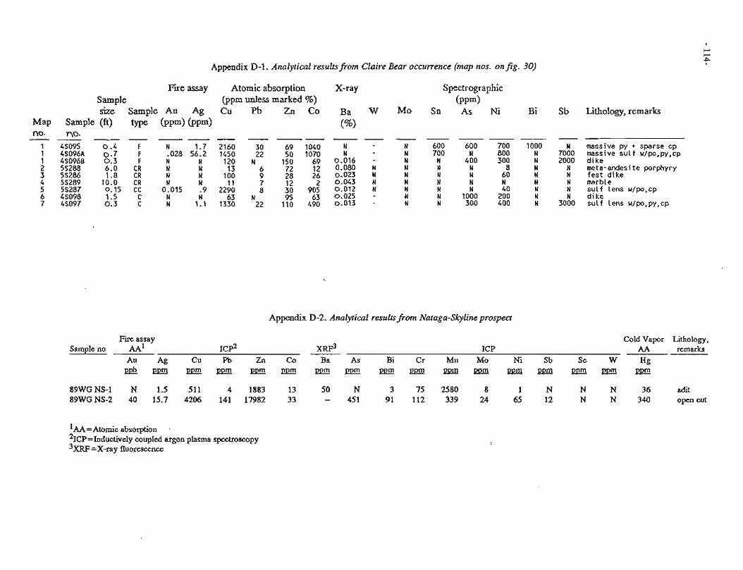
Appendix D-1. Analytical resultsfrom Claire Bear occurrence (map nos. onfig. 30)
Fire assay Sample size Sample Au Ag
Map Smple (ft) type ( P P ~ ) ( P P ~ ) no. no. - -- -- - - -
1 4S095 0 . 4 F N 1.7 1 48096A 0 . 7 F -028 56.2 1 480966 0 . 3 F N N 2 55288 6.0 CR N N 3 5S286 1.8 CR N N 4 58289 10.0 CR N N 5 55287 0.15 CC 0.015 - 9 6 4S098 1.5 C N N 7 45097 0.3 C N 1.1
Atomic absorption (ppm unless marked %) Cu Pb Zn Co
X-ray Spectrographic ( P P ~ )
Sn As Ni Bi Sb Lithology, remarks
N massive py + sparse cp 7000 massive sul f w/po,py,cp 2000 N dike mete-andesite porphyry
N f e s t d i k e N marble N sulf Lens u/po,cp N dike
3000 sulf lens w/po,py,cp
Appendix D-2. Analytical resultsfrom Nataga-Skyline prospect
Fire assay Cold Vapor Lithology, Sample no AA' IC$ X R F ~ ICP AA remarks
Au Ag Cu Pb Zn Co Ba As Bi Cr Mn Mo Ni Sb Se W Hg P e b P P m P D m D P m p D m P P m p p m m m m m m p D m p p m ~ p D m ~
89WG NS-1 N 1.5 511 4 1883 13 50 N 3 75 2580 8 1 N N N 36 adit 89WG NS-2 40 15.7 4206 141 17982 33 - 451 91 112 339 24 65 12 N N 340 open cut
'AA=~tomic absorption 2 ~ ~ ~ = ~ n d u c t i v e l y coupled argon plasma spectroscopy 3 ~ ~ ~ = ~ - r a y fluorescence
APPENDIX E. ANALYTICAL RESULTS FROM W;UKWAN LODE AND ALLUVIAL FAN DEPOSITS
Appendix - Title Page
E-1 Klukwan rock, stream-sediment, and pan-concentrate ....................................... 117
B-2 Metallurgical test results of sulfide samples from Klukwan lode deposit ............................... 136
Appendix E-1. Analytical methodr for Appendh E-1
Au, Pt, and Pd analyses were by Fire Assay - Atomic Absorption (Fa-AA), Inductively Coupled Argon Plasma Spectroscopy (ICP) or Fire Assay (FA),
Ag, Cu, Fe, V, and Ti analyses were by Atomic Absorption or X-ray fluorescence.
Where a number of analyses for either Au, Pt, and Pd were completed for a sample, the value estimated to be most accurate from available data is given.
San~ple analyses were by USBM Research Center in Reno, Nevada; TSL Laboratories in Spokane, Washington; and Bondar-Clegg, Inc., of Lakewood, Colorado.
Units of measure abbreviation used: ppm - parts per million; L0.0003 = not detected above the lower limit of detection, that is, 0.0003 oz/ton; G10.00 = greater than 10.00 percent; - = not analyzed.
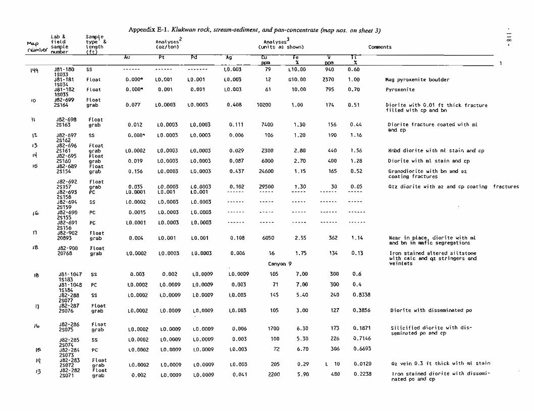
Appendix E-1. Klukwaa rock, stream-sediment, and pan-concentrate (map nos. on sheet 3) Lab & $amp\ eg, 2 3
- type Ana 1 yses Analyses M Mop f i e l d length (oz/ton) (un i t s as shown) Comnents ~i.&iW :a:; I
( f t ) Au Pt Pd ACI Cu Fe V T i -
PPn X -- X 1 lqq 581-180 88 - - - - - - - - - - - - - - - - - - - LO. 003 79 L10.00 940 0.60
1 SO33 j 8 1 l i 8 1 F loat O.OOO* LO.001 L0.001 LO. 003 12 610.00 2370 1.00 Mag pyroxenite boulder IS034 J81-182 F loat O.OOO* 0.001 0-001 LO -003 61 10.00 795 0.70 Pyroxenite 1 SO35 582-699 Float
lo 2S164 grab 0.077 L0.0003 L0.0003 0.408 10200 1-00 174 0.51 D i o r i t e wi th 0.01 f t t h i c k f racture f i l l e d wi th cp and bn
\ \ 582-698 FLoat 28163 grab 0.012 L0.0003 L0.0003 0.111 7400 1.30 156 0.44 D i o r i t e f racture coated w i th ml
and cp J82-697 SS '' 23162
O.OOO* L0.0003 L0.0003 0.006 106 1.20 190 1.16 -- 582-696 F loat
l3 2Sl6 l 14
grab L0.0002 L0.0003 L0.0003 0.029 2300 2.80 440 1.56 HnW d i o r i t e w i th ml s t a i n and cp J82-695 F loat 2S160 grab 0.019 L0.0003 L0.0003 0.087 6000 2.70 400 1.28 D i o r i t e wi th ml s t a i n and cp
15 J82-689 F loat 251 54 grab 0.156 L0.0003 L0.0003 0.437 24600 1.15 165 0.52 Granodior i te w i th bn and az
coat ing f ractures
Qtz d i o r i t e u i t h az and cp coat ing f ractures 582-692 F loat 25157 grab 0.035 L0.0003 L0.0003 582-693 PC L0.0001 L0.001 LO.OO1 3S158
-- .. - J82-902 F loat 20893 grab 0.004 LO.001 LO.001 Near in place d i o r i t e w i th ml
and bn in maf ( c segregations 582-900 F loat 20768 grab L0.0002 L0.0003 L0.0003 16 1.75
Canyon 9
105 7.00
71 7.00
145 5.40
I r o n stained a l te red s i l t s t o n e with calc and qz s t r ingers and v e i n l e t s
561-1047 SS 0.003 0.002 LO.0009 IS183 561-1048 PC L0.0002 L0.0009 L0.0009 IS184 582-288 SS L0.0002 L0.0009 L0.0009 2S077 J82-287 Float 25076 grab L0.0002 L0.0009 L0.0009
LO. 0009
0.003
L0.003
LO. 003 D i o r i t e w i th disseminated po
J82-286 F loat 2S075 grab ~0.0002 L0.0009 L0.0009 0.006
0.003
LO. 003
S i l i c i f i e d d i o r i t e u i t h d i s - seminated po and cp
2soTj- J82-283 F loat 25072 grab L0.0002 L0.0009 LO.0009 J82-282 F loat 25071 grab 0.002 LO. 0009 LO. 0009
Qz vein 0.3 f t t h i c k w i th ml s t a i n LO. 003
0.041 I r o n stained d i o r i t e u i t h dissemi- nated po and cp
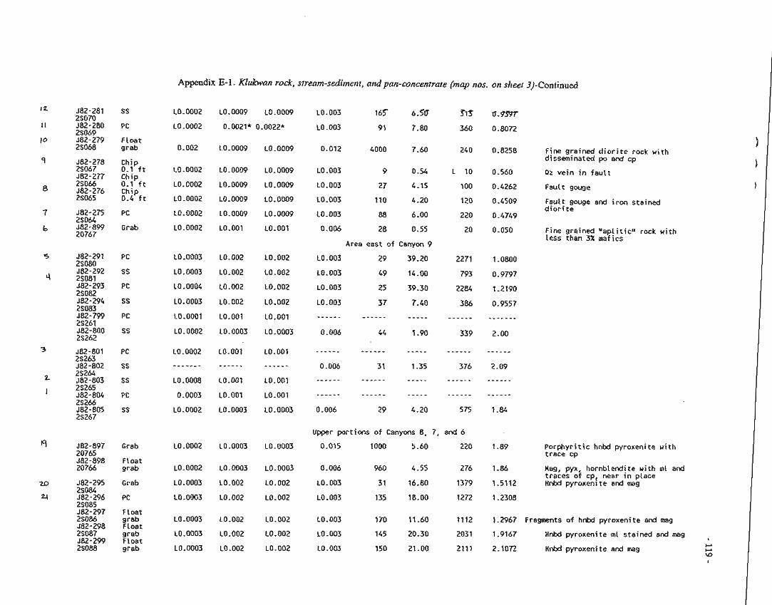
AppzdIx E-l . Klukwan rock, stream-sedimenr, and pan-concentrate (map nos. on sheer 3)-Continued
582-281 SS 25070 J82-280 PC 2S069 J82-279 Float 25068 grab o.on2
:o.0002
LO. 0002
LO.OOOi!
:0.0002
LO. 0002
L0.0003
LO. 0003
L0.0004
LO. 0003
L0.0001
LO. 0002
LO. 0009
L0.0009
L0.0009
LO. 0009
LO. 0009
L0.001
LO. 002
LO. 002
La. 002
L0.002
LO.001
LO. 0003
LO. 0009
LO. 0009
LO. 0009
L0.0009
L0.0009
LO.001
LO. 002
L0.002
LO. 002
L0.002
LO. 001
LO -0003
0.012 4000 7.60
LO. 003 9 0.54
L0.003 27 4.15
10.003 110 4.20
h0.003 88 6.00
0.006 28 0.55
Ares east o f Canyon 9
LO. 003 29 39.20
L0.003 49 14.00
LO. 003 25 39.30
LO. 003 37 7.40
- - - - - - - - - - - - - - - - -
0.006 44 ! -00
Fine grained d i o r i t e rock u i t h disseminated po and cp
Pz v e i n in f a u t t
FauCt gouge
Fault gouge and i r o n stained d i o r i t e
582-275 PC 25064 582-899 Grab 20767
Fine grained " a p l i t i c " rock u i t h less than 3% maf i c s
LO.0002
- - - - - - -
LO. 0008
0.0003
LO .@O02
LO.001
- - - - - -
LO.OO1
LO.001
LO. 0003
Upper por t ions of Canyons 8, 7, and 6
0.015 1000 5.60 220 1.89 Porphyr i t i c hnbd pyroxenite w i th t race cp
LO. 0003 LO. 0003 982-897 Grab 20765 582-898 Float 20766 grab 2-86 Hag, pyx, hornblendfte u i t h ml and
traces o f cp, near I n ptace 1.5112 Hnkl pyroxenlte and mag
LO. 0003
LO. 002
L0.002
0.006 960 4.55 276
LO. 003 31 16.80 1379
LO. 003 135 18.00 1272
LO. 0003
LO.002
LO. 002
J82-295 Grab 25084 582-296 PC 25085 582-297 Float 25086 grab J82-298 Float 25087 grab 582-299 Float 2S088 grab
1.2967 Fragments of hnbd pyroxenite 3rd m g
1.0167 Hnbd pyroxenite m l sta ined and mag
2.1072 HnM pyroxeni t e and mg
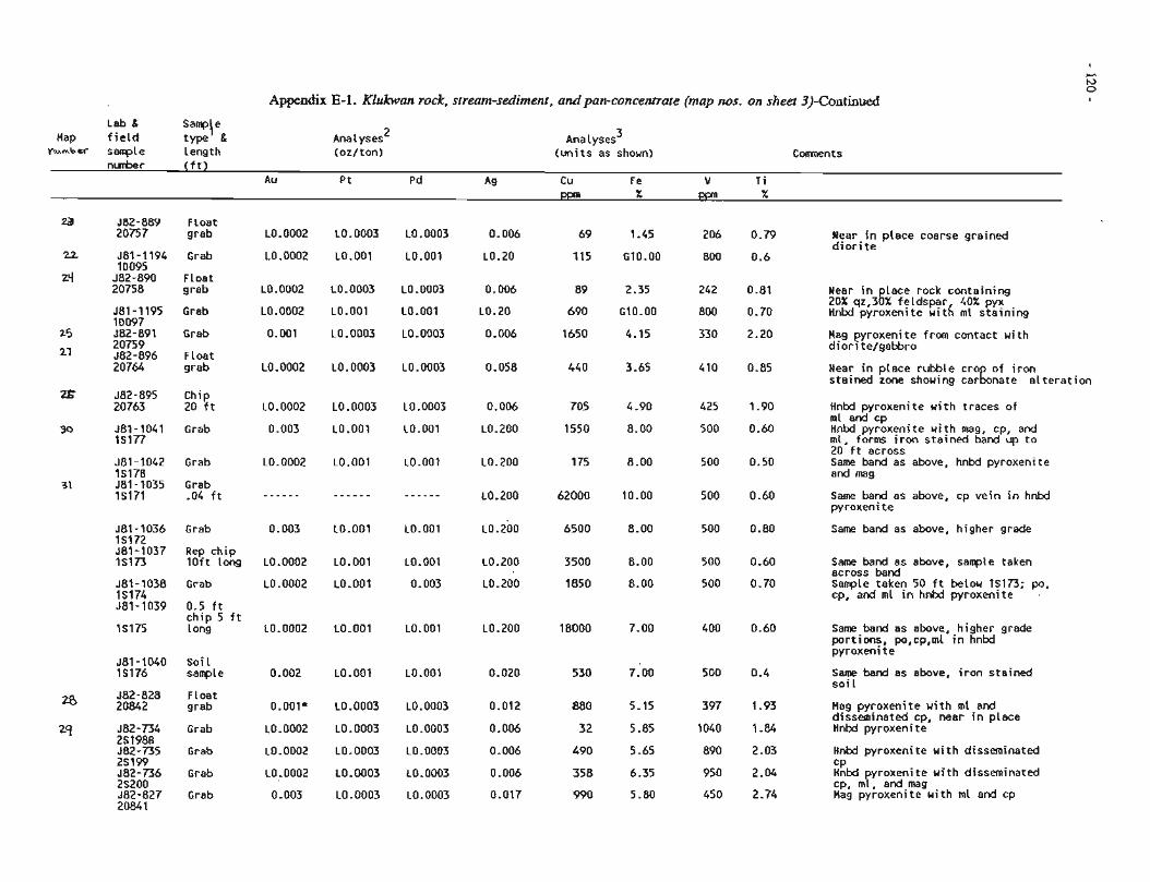
Appendix E-1. Klukwan rock, stream-sediment, and pan-concentrafe (map nos. on sheet 3)-Continued
Lab & Sam~\e Hap f i e l d type &
n~mbrr sanple Length Ana 1 yses 2
(oz/ton) Analyses 3
(un i t s as shown) C m n t s n h r ( f t )
Au Pt Pd Ag Cu F e V T i
Za J82-889 Float 20757 grab L0.0002 L0.0003 L0.0003 0.006 69 1.45 206 0.79 Near i n p lace coarse grained
d i o r i t e 22 J81-1194 Grab L0.0002 L0.001 LO.001 L0.20 115 G10.00 800 0.6
10095 ~ - - - .
Zq 582-890 Float 20758 grab L0.0002 L0.0003 L0.0003 0.006 89 2.35 242 0.81 Near i n Lace rock containing
20% q r , 3 k feldspar 40% pyx 581 - 1195 Grab L0.0002 LO.001 LO.001 L0.20 690 G10.00 800 0.70 H ~ W pyroxenite w i t h ml s ta in ing ID097 ~ 8 2 - 8 9 1 Grab
25 20759 21 582-896 Float
20764 grab
0.001
LO. 0002
LO. 0003
LO. 0003
Hag pyroxenite from contact wi th dior i te/gabbro
Near i n place rubble cro o f i r o n stained zone showing c a r k n a t e a l t e r a t i o n
z J82-895 Chip 20763 20 f t
30 581-1041 Grab IS177
LO. 0002
0.003
Hnbd pyroxenite w i th traces of ml and cp HnM pyroxenite w i th mag, cp, and ml, forms i r o n s ta ined band up t o 20 dt across Same band as above, hnbd pyroxenite and mag
J81-1042 Grab 15178
31 J81-1035 Grab IS171 -04 f t Same band as above, cp ve in i n hnbd
pyroxenite
J81-1036 Grab IS172 J81-1037 Repchip IS173 loft Long
Same band as above, higher grade
L0.0002
LO. 0002
L0.200
LO. 200
Same band as above, sarrple taken across band Sanple taken 50 f t below 1S173; po, cp, and ml in hnbd pyroxenite
581-1038 Grab IS174 581-1039 0.5 f t
ch ip 5 f t IS175 long Same band as above, higher grade
port ions, po,cp,ml i n hnbd pyroxenite
581-1040 Soi l 15176 sample Same band as above, i r o n stained
soi L . 582-828 Float 20842 grab O.OOlf L0.0003 L0.0003 0.012 880 5.15 397 1.93 Mag pyroxenite w i th ml and
disseminated cp, near i n place 582-734 Grab L0.0002 L0.0003 L0.0003 0.006 32 5 -85 1040 1.84 Hnbd pyroxenite *' 251988 J82-735 Grab L0.0002 L0.0003 L0.0003 0.006 b90 5 -65 890 2.03 HnM pyroxenite w i th disseminated 2S199 582-736 Grab L0.0002 L0.0003 L0.0003 0.006 358 6.35 950 2.04 ;Ktd yroxenite u i t h disseminated 2S200 cp, my, and mag 582-827 Grab 0 -003 L0.0003 L0.0003 0.017 990 5 -80 450 2.74 Mag pyroxenite w i th ml and cp 20841
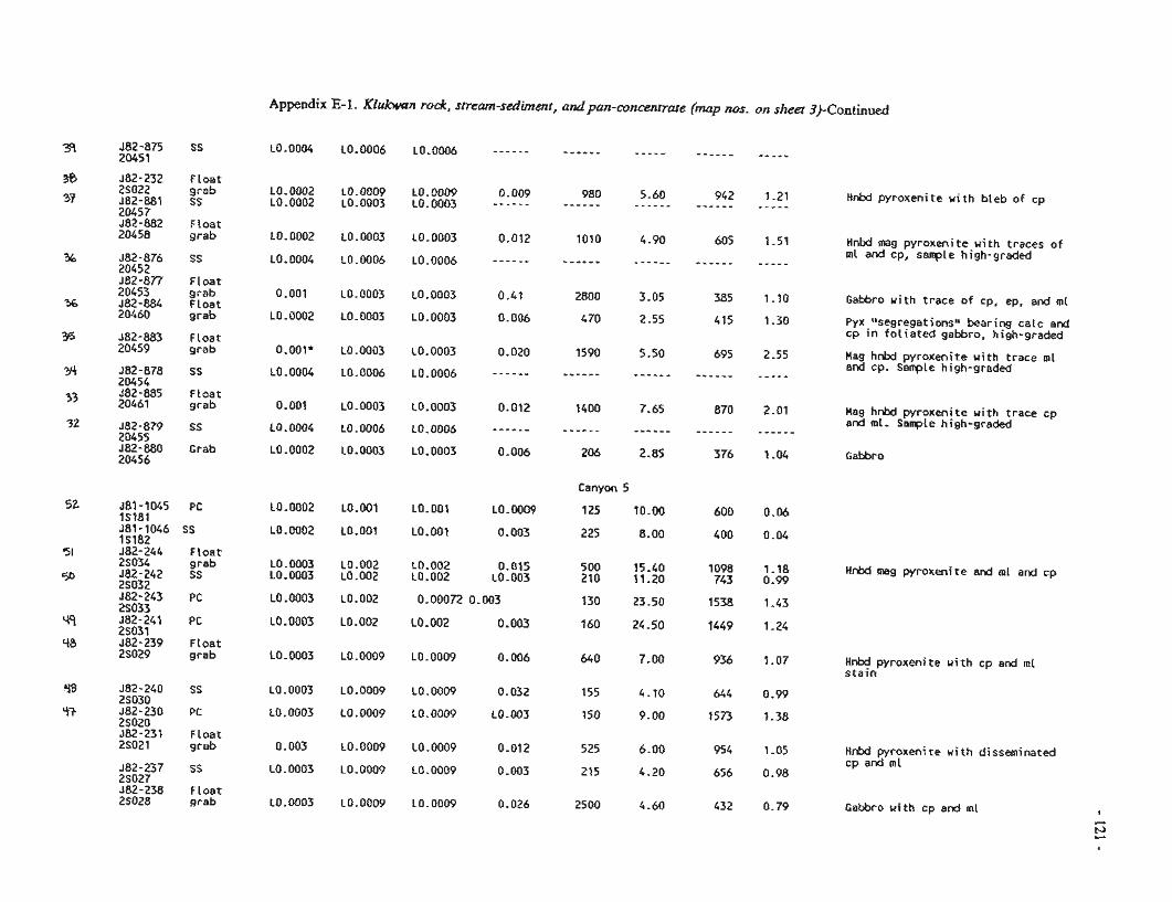
Appendix E-1. Klukwan rock, sfream-sediment, andpan-concentrate (map nus. on sheet 3)-Continued
582-232 Float 2SG22 ~ r a b 582-881 SS 20457 $82-882 F!cat 20458 grab
~0.0002 ea.000~ LO.OOOP 0.009 980 5-60 942 1.21 Hnbd pyroxenite w i th b leb of cp L0.0002 ~0.0003 L0.0003 - W e - - - - - - - - - - - - - - - - - - - - - - - - - -
L0.0002 L0.0003 L0.0003 0.012 1010 4.90 605 1.51 Hnbd mag pyroxeni te w i th traces o f
- - - - - - ml and cp, sarrple high-graded L0.0004 L0.0005 LO.0006 - - - - - - - - - - - - - - - - - - - - - - -
-. .-
582-877 F loa t 20453 grab 582-884 Float 20460 grab
0 .Q0! LO. 0003 LO. 0003 0-47 2800 3.05 385 1-10 Gabbro w i th t race o f cp, ep, and m l
L0.0002 L0.0003 L0.0003 0.006 4 70 2.55 415 1.30 Pyx lnsegregationsli bearing ca lc and cp i n f o l i a t e d gabbro, high-graded
582-883 Float 20459 grab O.OOlf LD.0003 L0.0003 0.020 1590 5.50 695 2.55 Hag hnbd pyroxenite w i th t race ml
and cp. Sarrple high-graded L0.0004 L0.0006 L0.0006 - - - - - - - - - - - - - - - - - - - - - - - - - - - - - 582-878 SS
20454 J82-885 F loa t 20461 grab 0.001 L0.0003 L0.0003 0.012 1400 7.65 870 2.01 Mag hnbd pyroxenite w i th t race cp
- - - - - - and ml. Sample high-graded L0.0004 L0.0006 L0.0006 - - - - - - - - - - - - - - - - - - " - - - - - JEZ-879 SS
20455 J82-880 Grab 20456
L0.0002 L0.0003 L0.0003 0.006 206 2.85 376 1.04 Gabbro
Canyon 5
LO.0002 L0.001 L0.001 L0.0009 125 10.00 600 0.06
L0.0002 L0.001 LO.001 0.003 225 8.00 400 0.04
LO -0003 LO.002 LQ.002 0.015 500 15.40 1098 1.18 L0.0003 L0.002 L0.002 LO. 003 210 11.20 743 0.99
Hnbd mag ~ y r o x e n i t e and ml and cp
H n b d pyroxenite w i th cp and m l s t a i n
J82-240 SS 2S030 582-230 PC 2S020 J82-235 FLoat 25021 grab HnM pyroxenite w i th disseminated
cp and m l J82-237 SS 25027 582-238 Float 25028 grab Gabbro u i t h cp and ml
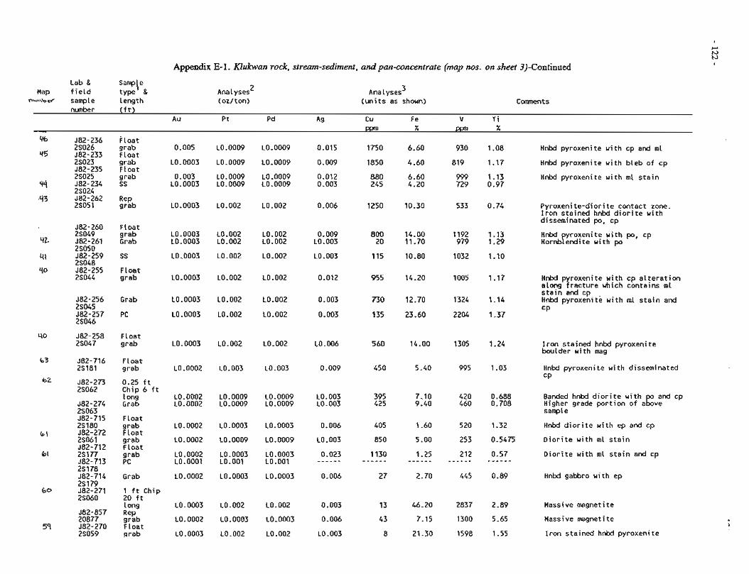
Appendix E-1. Klukwan rock, stream-sediment, and pan-concentrate (map nos. on sheet 3)-Continued
Lab & S a ~ \ e Map f i e l d type g
b e sample Length Analyses 2
(oz/ton) Analyses 3
( u n i t s as shown) nunber ( f t )
Au Pt Pd Ag C u Fe V T i Ppn % ppn X
J82-236 Float 2S026 grab J82-233 F loat 25023 grab J82-235 Float 26025 grab 582-234 SS 26024 J82-262 2S05l :%b
M n W pyroxenite w i th cp and ml
Hnbd pyroxenite u i t h b leb o f cp
Hnbd pyroxenite w i th ml s t a i n
Pyroxeni te-d ior i te contact zone. I r o n stained hnbd d i o r i t e u i t h disseminated po, cp
582-260 Float 25049 grab 582-261 Grab 25050 582-259 SS 25048 582-255 F loat 2S044 grab
Hnbd yroxenite w i th po, cp Hornbfendite u i t h po
H n W pyroxenite w i th cp a l t e r a t i o n along f rac tu re uhich contains ml s t e i n and cp Hnbd pyroxenite u i t h ml s t a i n and c P
582-256 Grab 26045 J82-257 PC 2S046
582-258 F loat 25047 grab LO. 006 I r o n stained hnbd pyroxenite
boulder wi th mag
Float grab
0.25 f t Chip 6 f t 1 ong Grab
Float grab Float grab F loat grab PC
Grab
1 f t Chip 20 f t 1 ong
:;:b Float grab
L0.0002
L0.0002 L0.0002
L0.0002
L0.0002
L0.0002 L0.0001
L0.0002
LO. 0003
L0.0002
LO. 0003
L0.003
L0.0009 L0.0009
L0.0003
L0.0009
L0.0003 L0.001
L0.0003
L0.002
LO. 0003
L0.002
L0.003
L0.0009 L0.0009
L0.0003
L0.0009
L0.0003 LO.OO1
L0.0003
L0.002
L0.0003
LO. 002
0.009
LO. 003 L0.003
0.006
LO -003
0.023 - - - - - -
0.006
0.003
0.006
LO -003
Hnbd pyroxenite w i th disseminated CP
Banded hnbd d i o r i t e w i th and cp Higher grade p o r t i o n o f a g v e sanple
Hnbd d i o r i t e wi th ep and cp
D i o r i t e wi th ml s t a i n
D i o r i t e wi th ml s t a i n and cp
Hnffl gabbro w i th ep
Massive magnetite
Massive magnetite
I r o n stained hnbd pyroxenite
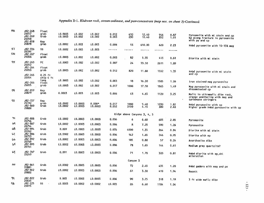
Appendix E-I. Klukwars rock, sirem-sebirneiii, a d pc?nLconceiitrate (imp 30s. on skeet 3)-Continued
f l o a t grab Grab
:;:b
ss
F loat grab
PC
Float grab
0.25 f t c h i p 4 f t 1 ong Float grab
:::b
Rep grab Grab
Grab
Grab
Grab
Grab
Grab
Grab
Grab
Grab
Grab
Grab
SS
Pyroxenlte u i t h m l s t a i n and cp Ep along f rac tu re in pyroxeni te u i t h py and cp
LO. 0003 L0.0003
LO.0002
LO. 0002
L0.0003
LO. 0003
L0.0003
LO. 0003
LO. 0003
0.0003
LO. 0002 LO. 0002
L0.0002
L0.0002
0.009
L0.0002
L0.0002
LO. 0002
0.001
LO. 0002
LO. 0002
0.003
L0.0003
LO.002 LO. 002
LO. 003
L0.003
LO. 002
LO.002
LO. 002
LO. 002
LO .002
L0.003
L0.0003 LO. 0003
L0.0003
LO. 0003
L0.0003
L0.0003
LO. 0003
LO. 0003
LO. 0003
LO. 0003
L0.0003
LO. 0003
L0.0002
L0.002 L0.002
LO. 003
L0.003
LO -002
L0.002
L0.002
LO. 002
LO. 002
L0.003
0. OOO* L0.0003
L0.0003
L0.0003
LO. 0003
L0.0003
LO. 0003
L0.0003
L0.0003
LO. 0003
L0.0003
L0.0003
L0.0002
Hnbd pyroxenite w i th 10-15% mag
D i o r i t e u i t h ml s t a i n
Hnbd pyroxenite u i t h ml s t a i n end cp
i r o n s ta ined mag pyroxenite
Hag pyroxenite u i t h rnl s t a i n end disseminated cp
Haf ic t o u l t ramaf i c d ike rock, orange ueathering u i t h mag and carbonate s t r ingers
Hnbd pyroxenite w i t h cp Higher grade hnbd pyroxenite wi th cp
Ridge above Canyons 3, 4, 5
0.006 6 6.60 605
0.006 8 7.25 590
0.076 4000 1.35 264
0.006 142 1.65 246
0.006 185 0.80 57
0.006 78 1.65 144
Pyroxeni t e
Pyroxenite
D i o r i t e w i t h ml s t a i n
D i o r i t e u i t h ep
Anorthosite d ike
Medim gray quar tz i te?
Hnbd d i o r i t e u i t h ep,chl a l t e r a t i o n
Canyon 3
0.006 72 2.45 435
0.006 61 3.30 410
Hnbd gabbro u i t h mag and po
Basalt
3 f t wide mafic d i k e
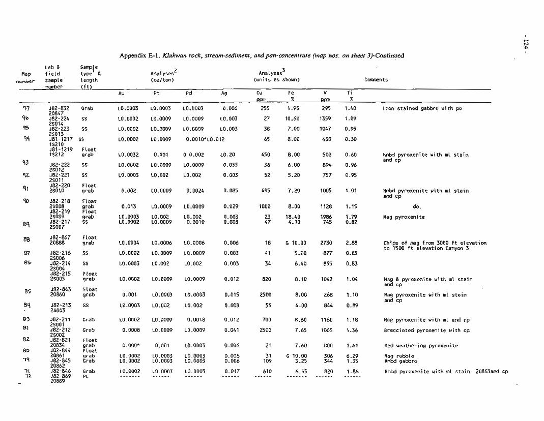
Appendix E-1. Klukwan rock, stream-sediment, and pan-concentrate (map nos. on sheet 3)-Continued I
Lab & S a ~ \ e Map f i e l d type 8
W Y H ~ sample length
Analyses 2
(oz/ton) Analyses 3
(un i t s as shown) Comnent s
- PPn X Ppm X -
582-832 Grab ~0.0003 L0.0003 L0.0003 0.006 255 1.95 295 1.40 I r o n s ta ined gabbro u i t h po '' 20847 9b 582-224 SS 10.0002 L0.0009 L0.0009 L0.003 27 10.60 1359 1.09
2S014 95 582-223 SS L0.0002 10.0009 L0.0009 10.003 38 7.00 1047 0.95
25013 581-1217 SS L0.0002 L0.0009 0.0010*L0.012 65 8.00 400 0.30
qq lS210 581-1219 Float 15212 grab 10.0032 0.001 0 0.002 L0.20 450 8-00 500 0.60 Hnbd pyroxenite w i th ml s t a i n
and cp 93 582-222 SS 10.0002 L0.0009 L0.0009 0.055 36 6.00 894 0.96
2so 12 582-221 SS L0.0003 L0.002 10.002 0.003 52 5 -20 757 0.95
q2 .?so11 -.
S I 582-220 Float 2S010 grab 0.002 L0.0009 0.0024 0.085 495 7.20 1005 1.01 Hnbd pyroxenite u i t h ml s t a i n
and CD - .-
% 582-218 Float 2S008 grab 0.013 L0.0009 10.0009 0.029 1000 8-00 1128 1.15 do. 582-219 F loat 2S009 grab L0.0003 10.002 L0.002 0.003 23 18.40 1986 1.79 Mag pyroxenite 582-217 SS L0.0002 L0.0009 0.0010 0.003 47 4.10 745 0.82
87 2S007
88 582-867 FLoat 20888 grab L0.0004 L0.0006 L0.0006 0.006 18 G 10.00 2730 2.88 Chips o f rneg from 3000 f t e levat ion
t o 1500 f t e levat ion Canyon 3 582-216 SS LO. 0002 LO. 0009 LO. 0009 0.003 41 5.20 877 0.85
87 2S006 86 582-214 SS L0.0003 L0.002 10.002 0.003 34 6.40 855 0.83
2S004 582-215 Float 2S005 grab ~0.0002 L0.0009 L0.0009 0.012 820 8.10 1042 1.04 Hag & pyroxenite w i th ml s t a i n
and co -r
85 582-843 Float 20860 grab 0.001 L0.0003 L0.0003 0.015 2500 8.00 268 1-10 Mag pyroxenite u i t h m l s t a i n
and cp 582-213 SS L0,0003 L0.002 L0.002 0.003 55 4.00 844 0.89
84 ZOO3
J82-211 Grab L0.0002 10.0009 0.0018 0.012 83 2SOOl 81 582-212 Grab 0.0008 10.0009 L0.0009 0.041
2S002 -- - -- 82 582-821 Float
20834 grab O.OOO* 0.001 10.0003 0.006 80 582-844 Float
20861 grab L0.0002 10.0003 10.0003 0.006 19 582-845 Grab ~0.0002 ~0.0003 ~o.onn3 0.006 ---- - -~ . -
20862 I1 582-846 Grab ~0.0002 L0.0003 L0.0003 0.017 72 582-869 PC - - - - - - - - - - - - - - - - - - - - - - - - -
20889 -
1160 1.18 Mag pyroxenite w i th ml and cp
1065 1.36 Brecciated pyroxenite w i th cp
800 1.61 Red ueathering pyroxenite
306 6.29 Hag rubble 344 1.35 HnM gabbro
820 1.86 Hnbd pyroxeni t e wi th ml s t a i n 20863and Cp - - - - - - - - - - -
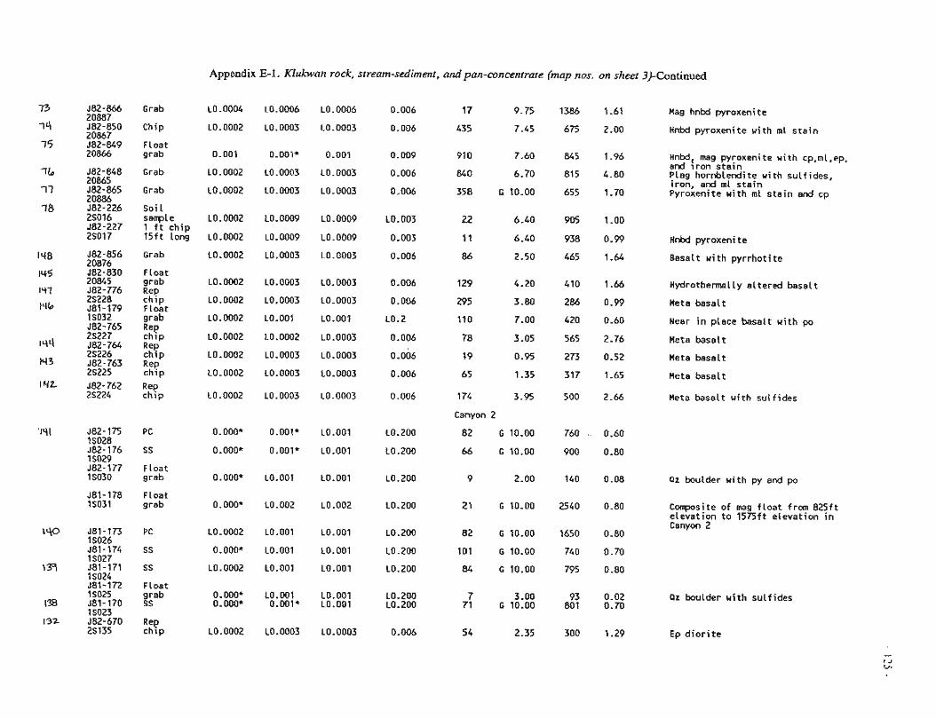
Appendix E-I. Kiukwnn rock, stream-sediment, and pan-concenrrate (map nos. on sheer 3)-Continued
Grab L0.0004 L0.0006 L0.0006 0.006 17 9.75 1386 1.61
Chip L0.0002 L0.0003 L0.0003 0.006 435 7.45 675 2-00
F loat grab 0.00i O.OOl4 0.00i 0.009 910 7.60 5 i.96
Grab L0.0002 L0.0003 L0.0003 0.006 840 6.70 815 4.80
Grab L0.0002 L0.0003 L0.0003 0.006 358 G 10.00 655 1.70
Soi i sanple L0.0002 L0.0009 L0.0009 L0.003 22 6.40 905 1.00 1 f t ch ip t 5 f t long L0.0002 LO.0009 10.0009 0.003 4 1 6.40 938 0.99
Hag hnbd pyroxenite
Hnbd pyroxenite w i th m i s t a i n
Hnbd, mag pyroxeni t e w i t h cp,mi ,ep, and i r o n s t a i n Plag hornblendite w i th su l f ides, i ron, and st s t a i n Pyroxenite w i t h ml s t a i n end cp
HnW pyroxenite
582-856 Grab L0.0002 L0.0003 L0.0003 0.006 86 2.50 465 1.64 Basalt w i th p y r r h o t i t e 20876 582-830 F loat 20845 grab L0.0002 L0.0003 L0.0003 0.006 129 4.20 410 1.66 Hydro thena l l y a l te red basal t J82-776 Rep 2S228 c h i p L0.0002 L0.0003 L0.0003 0.006 295 3.80 286 0.99 Meta basal t 581-179 F loat IS032 grab LO.0002 LO.OO1 L0.004 L0.2 110 9.00 420 0.60 Near i n place basal t w i th po 582-765 Rep 25227 ch ip L0.0002 L0.0002 L0.0003 0.006 78 3.05 565 2.76 Mete basa l t 582-764 2S226 %!'p LO.0002 L0.0003 L0.0003 0.006 19 0.95 273 0.52 Meta basal t 582-763 Rep 2S225 c h i p L0.0002 L0.0003 L0.0003 0.006 65 1.35 317 1.65 Heta besal t 582-762 Rep 25224 c h i p LQ.0002 L0.0003 L0.0003 0.006 174 3-95 500 2.66 Mete basal t with su l f i des
Canyon 2
1 SO28 982-176 SS 0.000* O - O O l * L0.001 LO .ZOO 66 G 10.0Q 900 0.80 1 SO29 582-177 F loat 15030 grab 0.000* L0.901 L0.001 LO. 200 P 2.0Q 140 0.08 Q t boulder x i t h py and po
581-178 Float IS031 grsb 0.000* L0.002 LO.002 LO.200 21 G 10.00 2540 0.80 C w s i t e of mag f l o a t f r m 825 f t
e leva t ion t o 1575ft e leva t ion i n Canyon 2
J81-173 PC L0.0002 L0.001 L0.001 LO. 200 82 G 10.00 1650 0.80
1 SO27 581-171 SS L0.0002 L0.001 LO.001 LO. 200 84 G 10.00 795 0.80 1 SO24 581-172 FLost 15025 grab 0-DOO* L0.001 LO.OO1 L0.200 7 3.00 93 0-02 P z boulder w i th su l f i des 581-170 SS O.OOO* O.0Ol2 L0.001 10.200 71 G 10.00 801 0.70 1 SO23 582-670 Rep 25135 c h i p L0.0002 L0.0003 L0.0003 0.006 54 2.35 300 1.29 Ep d i o r i t e
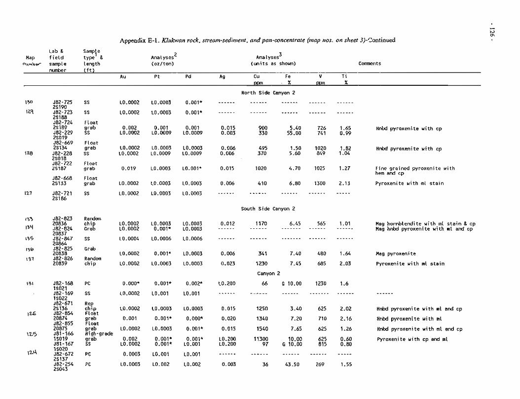
Appendix E-1. Klukwn rock, stream-sediment, and pan-concentrate (map nos. on sheet 3)-Continued
Lab & Sam~\e Map f i e l d tYPe 'I
n k w b ~ sample length ~ n a 1 yses'
(un i t s as shown)
ss
SS
Float grab SS
Float grab SS
Float grab
Float grab
ss
Random
:h,2 SS
Grab
Random chip
PC
SS
:zp Float grab Float grab High-grade grab SS
PC
PC
L0.0002
L0.0002
0.002 LO. 0002
L0.0002 LO. 0002
0.019
LO. 0002
LO. 0002
L0.0002 LO -0002
LO. 0004
L0.0002
LO. 0002
0. OOO*
L0.0002
L0.0002
0.001
L0.0002
0.002 L0.0002
0.0003
L0.0003
10.0003
LO. 0003
0.001 L0.0009
L0.0003 L0.0009
L0.0003
L0.0003
L0.0003
L0.0003 0.001'
L0.0006
0.001'
L0.0003
0.001*
L0.001
LO. 0003
0.001'
LO. 0003
0.001' 0.001*
LO.001
L0.002
0.001*
0.001*
0.001 L0.0009
LO. 0003 L0.0009
LO.OOl*
L0.0003
L0.0003
L0.0003 L0.0003
LO. 0006
L0.0003
LO. 0003
0. OO2*
L0.001
LO. 0003
o.ooo* 0.001*
0.001* LO.001
L0.001
LO. 002
- - - - - - - - - - - -
0.015 0.003
0.006 0.006
0.015
0.006
- - - - - -
0.012 - - - - - -
- - - - - -
0.006
0.023
L0.200
- - - - - -
0.015
0.020
0.015
L0.200 LO. 200
- - - - - -
0.003
North Side Canyon 2
- - - - - - - - - - - -
South Side Canyon 2
34 1 7.40
1230 7.45
Canyon 2
66 G 10.00
- - - - - - - - - - - -
Hnbd pyroxenite w i th cp
Hnbd pyroxenite u i t h cp
Fine grained pyroxenite u i t h hem and cp
Pyroxenite w i th ml s t a i n
Mag hornblendite w i th ml s t a i n & cp Mag hnbd pyroxenite w i th ml and cp
Mag pyroxenite
Pyroxenite w i th ml s t a i n
Hnbd pyroxenite w i th ml and cp
Hnbd pyroxenite w i th ml
Hnbd pyroxeni t e w i th ml and cp
Pyroxeni t e w i t h cp and m l
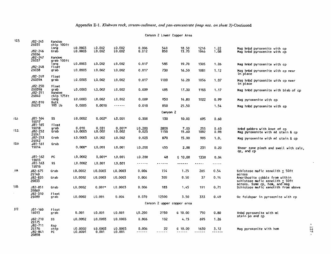
Appendix E-P . Klukwan rock, stream-sedimerzi, and pan-concentraze (map nos. on sheet 3)-Continued
Canyon 2 Lower Copper Area
Random ch ip 500f t Long L0.0003 LO.002 L0.002 0.006 540 18.50 1216 1-22 Hag hnbd pyroxenite w i th cp Grab L0.0003 L0.002 L0.002 0.012 850 13.70 1046 1.08 Hag hnbd pyroxenite w i th cp
grab lOOft i ong 10.0003 L0.002 i0.002 0.0i7 585 59.70 1305 5.26 Mag hnbd pyroxenite w i th cp Float grab L0.0003 L0.002 L0.002 0.017 730 16.50 1081 1.12 Hag hnbd pyroxenite w i th cp near
in d a c e Float grab L0.0003 L0.002 L0.002 0.017 1100 16.20 1056 1.07 Hag hnbd pysoxenite w i th cp near
in place Float grab L0.0003 L0.002 L0.002 0.009 495 17.30 1183 1.17 Hag hnkd pyroxenite w i th b leb of cp Random ch ip l r j f t 1 ong L0.0003 L0.002 L0.002 0.009 95 0 14.80 1022 0.99 Hag pyroxenite w i th cp Bulk 193 lb 0.0005 0.0010 - - - - - - 0.018 850 25.50 1.54 Hag hnW pyroxenite w i th cp
Canyon 2
Float ~~- -
grab 0.010 0.031 0.001* L0.200 2800 7.00 255 0.40 H n W gabbro w i th knot o f cp Grab L0.0003 L0.002 L0.002 0.023 1150 15.60 1092 0.98 Mag pyroxenite u i t h m l s t a ~ n & cp
Grab L0.0003 L0.002 L0.002 0.023 870 15.90 995 1.0. Hag pyroxenite wi th m l s t a i n & cp
Grab 0-OOO* L0.001 LO.001 L0.200 455 2.00 231 0.20 Shear zone pinch and sue11 w i th calc,
qz, and CP
Grab L0.0002 L0.0003 L0.0003 0.006 154 1.25 265 0.54 Schistose mafic xeno l i th + 5 0 f t 8CrOSS
Grab L0.0002 L0.0003 L0.0003 0.006 305 0.50 37 0.14 Anorthosite cobble from w i t h i n schistose mafic xeno l i th + S o f t across. some cp, hem and-mag
Crab L0.0002 0.001* L0.0003 0.006 183 1.45 191 0.71 Schistose mafic xeno i i th from above
Float grab L0.0002 LO.001 0.004 0.070 12500 3.50 333 0.49 Qz feldspar i n pyroxenite u i t h cp
Canyon 2 upper copper area
FLoat grab 0-001 LO.001 LO.001 LO. 200 2150 G 10.00 750 0.80 Hnbd pyroxenite w i th m l
s t a i n po and cp SS L0.0002 L0.0003 L0.0003 0.006 102 4.15 695 1.26
Rep ch ip L0.0002 10.0003 L0.0003 0.006 22 G 10.00 1630 3.12 Hag pyroxenite w i th hem PC LO.0001 0.001 LO.001 - - - - - - - - - - - - - - - - - - - - - - - - - - - - - -
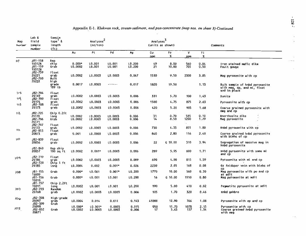
Appendix E-1. Klukwan rock, stream-sediment, andpan-concentrate (map nos. on sheet 3)-Continued
Lab & Sampie Map f i e l d type g Analyses 2
rumkef sample length (oz/ton) Analyses 3
(un i t s as shown) C m n t s
0. OOO* LO. 0002
L0.200 LO. 200
Iron sta ined mafic d i k e Fault gouge
Float grab But k h igh grade 189 l b
Hag pyroxenite u i t h cp
LO. 0003 Bulk sanple of hnbd pyroxenite with-mag cp, and ml, f l o a t and In pIace
F loat grab F loat grab F loat grab
Chip O.2ft l ong Grab
Float grab Float grab
Float grab
Rep ch ip 100 sq f t
LO. 0002
LO. 0002
L0.0002
Pyroxenite u i t h cp
Coarse grained pyroxenite u i t h mag and cp
Anorthosite d ike Mag pyroxenite
LO. 0002 L0.0002
Hnbd pyroxenite w i th cp LO. 0003
L0.0003 Coarse grained hnbd pyroxenite u i t h blebs o f cp
Segregation of massive mag i n hnW pyroxeni t e
Hnbd pyroxenite u i t h some rnl and CD
109 582-719 Float 25184 srab L0.0002 LO.0003 L0.0003 0.009 690 4.90 815 1.59 Pyroxenite w i th ml and cp 582-720 C h i p l f t 2S185 long LO. 0004 0.002 O.OOlf 0.026 2230 2.05 168 0.08 Pz feldspar v e i n w i th blebs o f
CP 1 08 581-155 Grab O.OOO* LO.001 0.001* LO. ZOO 1770 10.00 560 0.30 Mag pyroxeni t e u i t h po and cp
1 SO09 a t adzt 581-156 Grab O.OOO* LO.OO1 L0.001 LO. 200 16 G 10.00 1910 0.80 Mag pyroxenite a t e d i t 15010 581-157 Chip 2.2ft 1SOll long L0.0002 LO.001 LO.001 10,200 190 5.00 410 0.02 Pegmatite pyroxenite a t e d i t
107 582-703 Random 2S168 grab L0.0002 L0.0003 L0.0003 0.006 105 1 .TO 320 0.46 Hnbd gabbro
10 b J82-308 High-grade 28097 grab L0.0004 0.014 0.011 0.143 41000 12.90 766 2 -08 Pyroxenite u i t h ep and cp 582-309 Grab
105. 28098 LO.OOO* LO.OOl* 0.0003 0.015 950 11.70 1078 2.15 Pyroxenite w i th c 582-852 Grab L0.0002 L0.0003 L0.0003 0.006 17 5.45 127 1.34 Coarse grained h& pyroxenite 20871 w i th mag
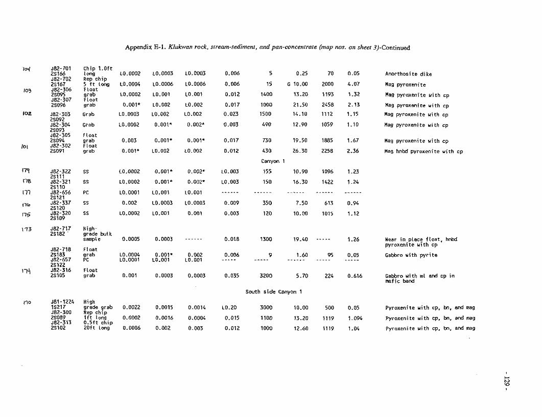
Appendix E-1. Klukwan rock, stream-sediment, md pan-concenrrate (map nos. on sheet 3)-Continued
582-701 C h i p l . 0 f t 2s 166 i ong L0.0002 LO.DDC3 L0.0003 0.005 5 0.25 70 0.05 Anorthosite d ike 582-702 Rep ch ip 2S167 5 f t long L0.0004 L0.0006 10.0006 0.006 15 6 10.00 2000 4.07 Hag pyroxenite 582-306 Fioat 2S095 grab ~0.0002 LO.001 LO.OO1 0.012 1400 13.20 1193 1.32 Hag pyroxeni t e w i th cp 582-307 Float 2S096 grab O.OGi* 10.002 LO.OC2 0.017 ! 000 21.50 2458 2.13 Hag pyroxenite u i t h cp
J82-303 Grab 23092 582-304 Grab 25093 562-305 Float 2SO94 grab 582-302 Float 2SO91 grab
0.023
0.003
0.017
0.012
L0.003
LO. 003
- - - - - -
0.009
0.003
1500
490
730
430
Canyon 1
155
150
- - - - - 350
120
1.15 Mag pyroxenite wi th cp
1.10 Hag pyroxeni t e u i t h cp
1.67 Hag pyroxenite wi th cp
2.36 Mag hnbd pyroxenite u i t h cp
J82-717 High- 2S182 ' grade bulk
sample 0.0005 0.0003 - - - - - - 0.018 1300 19.40 - - - - - 1.26 Near i n place f loa t , hnW wyroxenite u i t h m . . -r
582-718 Float 25 183 grab L0.0004 O.OOlt 0.002 0.006 9 1.60 95 0.05 Gabbro w i th p y r i t e 582-657 PC LO.C!QC!! LO.@@! LO.OO1 - - - - - - - - - - - - - - - - - - - - - - - - - - 2Sl22 582-316 Float 2S105 grab c.001 0.0003 0.0003 0.035 3200 5.70 224 0.616 Gabbro u i t h rnl end cp i n
maf i c band
South s ide Canyon 1
561-1224 High IS217 grade grab 0.0022 0.0015 0.0014 L0.20 3000 10.00 500 0.05 Pyroxeni t e w i th cp, bn, and 582-300 Rep chip 26089 l f t long 0.0002 0.0016 0.0004 0.015 f 100 13.20 1119 1.096 Pyroxenite w i th cp, bn, and mag 582-313 0.5ft chip 2Sl02 2 0 f t l o n g 0.0006 0.002 0.003 0.012 1000 12.60 1119 1.04 Pyroxenite u i t h cp, bn, and mag
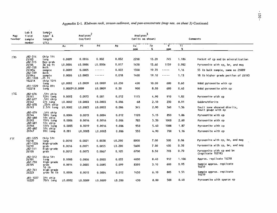
Appendix E-1. Klukwan rock, stream-sediment, and pan-concentrate (map nos. on sheet 3)-Continued
Lab & Sam!J{e Hap f i e l d type
N * M ~ sample length Ana 1 yses 2
(oz/ton) Analyses 3
(un i t s as shown) nunber ( f t )
Au Pt Pd Ag Cu Fe V T i ppn X ppn X
I70 J82-314 Chip l f t 25103 long 0.0009 0.0016 0.002 0.032 2200 13.20 745 1.186 582-315 Rep grab 25104 36 sq f t L0.0004 L0.0006 LO.0006 0.017 1450 13.60 1159 0.982 582-728 Bulk 2S193s 0.0009 0.0005 - - - - - - 0.022 1300 19.70 - - - - - 582-729 i;xle 1.16
2S194s sample 0.0006 L0.0003 - - - - - - 0.018 1400 19.10 - - - - - 1.13 J81-1228 .25 f t 1S221A ch ip 1 2 f t
long L0.0002 L0.0009 L0.0009 L0.200 450 10.00 600 0.60 581-1229 Chip 8 f t IS2210 long 0.0003*L0.0009 L0.0009 0.30 900 8.00 600 0.40
172 582-676 .5 f t ch ip 2S141 12 f t long 0.0003 0.0015 0.001 0.012 1115 4.90 910 1.82 582-677 .5 f t ch ip 2S142 4 f t long L0.0002 L0.0003 L0.0003 0.006 68 2.10 230 0.91 582-678 .25ft ch ip 2S143 2.5ft long L0.0002 10.0003 L0.0003 0.006 345 2.90 360 1.36
.5 f t c h i p l o f t long l f t ch ip 1 5 f t long l f t ch ip l l f t long l f t ch ip 9 f t long
Pocket o f cp and bn minera l izat ion
Pyroxenite u i t h cp, bn, and mag
55 Lb bulk sample, same as 2S089
18 l b higher grade p o r t i o n o f 2S193
Hnbd pyroxenite wi th cp
Hnbd pyroxenite u i t h cp
Pyroxenite u i t h cp
Fault zone sheared d i o r i t e , f a u l t gouge u i t h ep
Pyroxenite u i t h cp
Pyroxenite with cp
Pyroxenite u i t h cp
Pyroxenite wi th cp
17 1 J81-1225 Chip 5 f t IS218 l ong 0.0010 0.0021 0.0038 L0.200 8000 7.00 500 0.06 Pyroxenite with cp, bn, and mag 581-1226 High-grade IS219 grab 0.0016 0.0071 0.0055 L0.200 5600 7.00 400 0.30 Pyroxenite with cp, bn, and mag 582-311 High-grade 25100 grab 0.0012 0.0073 0.0067 0.105 6700 8.50 793 0.70 Pyroxenite u i t h cp and bn
( r e ~ l i c a t e 15219) - . J82-312 Chip 5 f t 2S101 long 0.0008 0.0006 0.0003 0.055 4000 8.40 912 1.106 Approx. rep l i ca te 15218 582-730 High-grade 2S195 grab 0.0014 0.0085 0.0085 0.099 8300 3.10 600 0.93 Sample approx. rep l i ca te
16 l b IS219 582-761 ~ i ~ h - ~ r a d e 26223 grab 16 l b 0.0004 0.0015 0.0004 0.012 1430 6.10 805 1.51 Sample approx. rep l i ca te
lS219 -
581-1227 3 f t ch ip Is220 70 f t long L0.0002 LO.0009 L0.0009 ~0.200 430 8-00 500 0.40 Pyroxenite wi th sparse cp
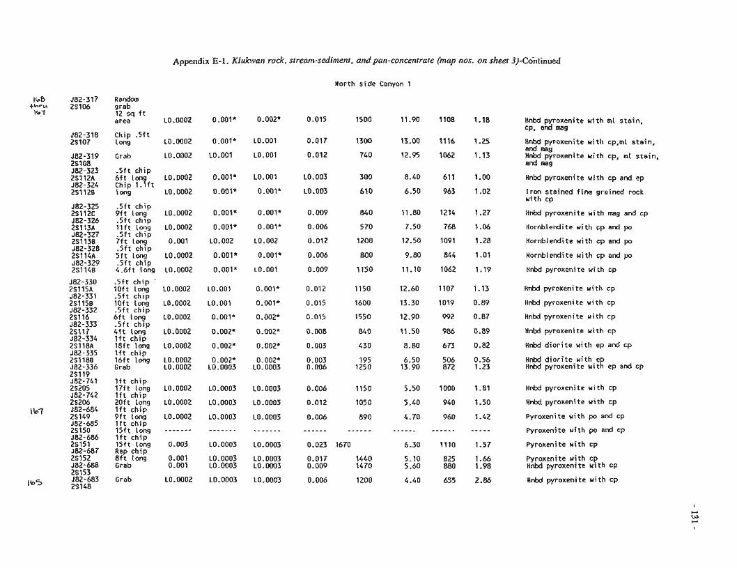
Appendix E-1. Kiuhun rock, stream-sediment, ardpQn-concentrate (map nos. on sheer 3)-Continued
North side Canyon 1
grab 12 sq f t area L0.0002 0.001* 0.002* 0.015 1500 11.90 ! ! O E 1.?8 Hn!d ~ i ~ x e n i i e with mi sta in ,
CP, and Chip .sf€ l ong L0.0002 0.001* L0.001 0.017 1300 13.00 ?I!& ! -25
Grab L0.0002 L0.001 LO.001 0.012 740 12.95 1062 1.13
HnM p j i o x e ~ i t e u i t h cp,mi stain, and mag Hnbd pyroxenite u i t h cp, ml stain, and ;nag
- 5 f t ch ip 6 f t Lon L0.0002 0.001' LO.OO1 L0.003 300 8.40 611 1-00 Chip 1.Qft long L0.0002 0.001* 0.001* LO. 003 610 6.50 963 1.02
Hnbd pyroxenite u i t h cp and ep
i r o n stained f i n e grained rock with cp
.5 f t ch ip 9 f t long .5 f t ch ip l l f t long .5 f t ch ip 7 f t long .5 f t ch ip 5 f t long .5 f t ch ip 4.6ft long
.5 f t ch ip ' l o f t long .5 f t ch ip l o f t long .5 f t ch ip 6 f t long .5 f t ch ip 4 f t long l f t ch ip 18 f t long l f t ch ip 16 f t long Grab
L0.0002
LO. 0002
0.001
L0.0002
LO. 0002
O.OOl*
o.ooa* LO. 002
0.001*
0.0011*
0.001*
0.001*
LO. 002
0.001*
L0.001
Hnbd pyroxenite w i th mag and cp
Kornblendite u i t h cp and po
Hornblendite wi th cp and po
Hornblendite wi th cp and po
KnM pyroxeii ite w i th cp
Hnbd pyroxenite u i t h cp
Hnbd pyroxenite u i t h cp
Hnbd pyroxenite u i t h cp
Hnbd pyroxenite u i t h cp
Hnbd d i o r i t e u i t h ep and cp
Hnbd d i o r i t e u i t h e Hnbd pyroxeni t e u i t/ ep and cp
1 f t ch ip 17 f t long l f t ch ip 20 f t long l f t ch ip 9 f t long l f t ch ip l S f t Long l f t ch ip 15 f t tong Rep ch ip 8 f t long Grab
HnW pyroxenite u i t h cp L0.0002
L0.0002
LO. 0002
L0.0003
LO. 0003
LO. 0003
LO. 0003
L0.0003
L0.0003
Hnbd pyroxenite w i th cp
Pyroxenite u i t h po and cp
Pyroxenite u i t h po and cp
LO. 0003 Pyroxenite u i t h cp
L0.0003 LO. 0003
Pyroxenite wi th cp Hnbd pyroxenite u i t h cp
Grab L0.0002 LO.0003 L0.0003 0.006 1200 4.40 655 2.86 Hnbd pyroxenite u i t h cp
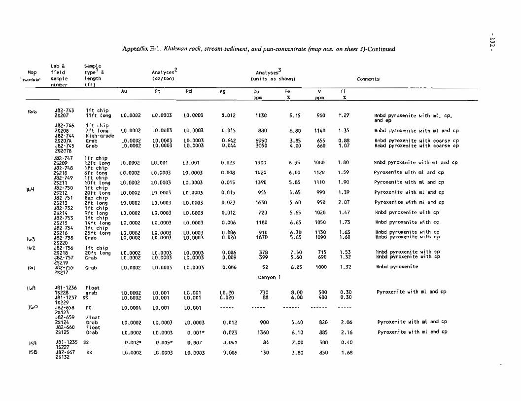
Appendix E-1. Klukwan rock, stream-sedimetit, atuipan-concentrate (map nos. on sheet 3)-Continued
Lab & Samp! e Hap f i e l d type &
nmmber sample length Analyses 3
(un i t s as shown) nunber ( f t )
Au Pt Pd Ag Cu Fe V T i
\b b 582-743 l f t ch ip 25207 l t f t long L0.0002 L0.0003 L0.0003 0.012 1130 5.15 900 1.27 Hnbd pyroxenite w i th ml. cp. . .
and ep- 682-7L6 l f t c h i o . . - - . . . 2 ~ 2 0 8 - - 7 f t ion; LO-0002 L0.0003 L0.0003 0.015 880 6.80 1140 1.35 Hnbd pyroxenite wi th ml and cp 582-744 High-grade 2S207A Grab L0.0002 L0.0003 L0.0003 0.642 6950 3.85 655 0.88 Hnbd pyroxenite u i t h coarse cp 582-745 Grab L0.0002 L0.0003 L0.0003 0.044 3050 4.00 660 1.07 Hnbd pyroxenite w i th coarse cp 252078
l f t ch ip 1 2 f t Long l f t c h i p 6 f t long l f t c h i p l o f t long l f t c h i p 2Of t long Rep c h i p 2 f t long l f t ch ip 9 f t long l f t c h i p 1 4 f t Long l f t c h i p 2 5 f t long Grab
l f t c h i p 2Oft long Grab
Grab
L0.0002
LO. 0002
L0.0002
LO. 0002
LO. 0002
LO -0002
LO. 0002
LO.001
L0.0003
L0.0003
L0.0003
L0.0003
LO. 0003
L0.0003
LO.001
L0.0003
LO. 0003
LO. 0003
LO. 0003
L0.0003
L0.0003
Hnbd pyroxenite u i t h ml and cp
Pyroxenite u i t h ml and cp
Pyroxenite u i t h ml and cp
Pyroxenite u i t h ml and cp
Pyroxenite wi th rnl and cp
Hnbd pyroxeni t e with cp
Hnbd pyroxenite u i t h cp
Hnbd pyroxenite with cp Hnbd pyroxenite wi th cp
L0.0002 LO. 0002
L0.0003 LO. 0003
Hnbd pyroxenite u i t h cp Hnbd pyroxeni t e u i t h cp
Hnbd pyroxeni t e
LO. 0003 LO. 0003
LO. 0003 L0.0003
LO. 0003 52
Canyon 1
l bq 581-1236 Float IS228 grab L0.0002 LO.001 L0.001 LO. 20 730 8.00 500 0.30 Pyroxeni t e ui t h ml and cp 581-1237 SS L0.0002 LO.001 LO.001 0.020 88 6.00 400 0.30 1 S229
582-659 Float 25124 Grab L0.0002 L0.0003 L0.0003 0.012 900 5 -40 820 2.06 582-660 Float 25125 Grab L0.0002 L0.0003 0.001' 0.023 1360 6.10 885 2.16
Pyroxeni t e with m l and cp
Pyroxeni t e wi th rnl and cp
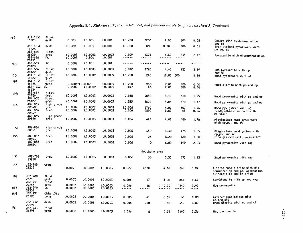
Appendix E-1. Klukwan rock, stream-sediment, and pan-concentrate (map nos. on sheet 3)-Continued
J81-1233 Float 15225 qrab LO. 200 2200
L0.200 860
Gebrc s i t h dissm;;ina:ed p and cp I r o n stained pyroxenite with po ex! cp
582-1234 Grab L0.0002 LO.001 LO.001 IS226
Float
?rb LO. 0003 0.004
LO.001
L0.0003
LO. 0009
Pyroxenite with disseminated cp
Float qrab r l o a t
Hnb p roxeni t e wi th cp and mr H P M pyroxen? t e with m l
Hnhd d i o r i t e u i t h p a i d cp
Float
AZt %$-grade grab Grab
L0.0002
L0.0002
LO. 0002 LO. 0002
LO. 0003
L0.0003
L0.0003 LO.0003
Hnbd pyroxenite u i t h cp and ep
!nX pyroxenite u i t h cp s d ep
HRW-pyx gabbro wi th in1 F e l d s ~ t h l c dike rock with ml stamn
High-grade grab LO. 0002 LO. 0003 LO. 0003 Plagioclase hnbd pyroxenite
wi th cp,po. and py
582-836 High-grade 20851 grab L0.0002 L0.0003 L0.0003
582-837 Grab L0.0002 L0.0003 L0.0003 20853 582-838 Grab L0.0002 L0.0003 L0.0003 20854
Plagioclase hnW gabbro w i th CP,po, and ml Fine grained ST!!, e d e s i t i c ?
Hnbd pyroxenite wi th mag
Southern area
582-786 Grab LO.0002 L0.0003 L0.0003 0.006 38 5.55 775 1.13 Hnbd pyroxenite with mag 25248
Grab 0.004 L0.0003 L0.0003 0.029 265 0.99 Altered hnbd d i o r i t e with d i s -
seminated-cp and po. Al te ra t ion c l i nozo is i te and c h l o r i t e
Float grab L0.0002 L0.0003 L0.0003 0.006 Float
865 1.64 Hornblendite with ep and mag
1240 2.92 Mag pyroxeni t e - - - - - grab L0.0002 L0.0003 L0.0003 0.006 SS L0.0002 L0.0003 L0.0003 - - - - - -
Chip - 3 f t 1 ong L0.0002 L0.0003 L0.0003 0.006 65 0.08 Altered lagioclase with
ep ad-cK! 450 0.82 Hnbd d ~ o r i t e u i t h ep and c1 Grab LO.0002 L0.0003 L0.0003 0.006
FLoat grab L0.0002 L0.0003 L0.0003 0.006 2100 2.36 Mag pyroxenite
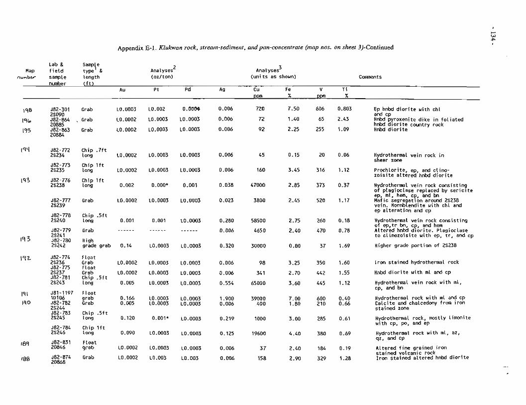
Appendix E-1. Klukwan rock. stream-sediment, and pan-concentrate (map nos. on sheet 3)-Continued
Lab & S a ~ \ e Map fietd type &
number sarrple length Analyses 2
(oz/ton) Analyses 3
(units as shown) nunber (ft)
Au Pt Pd Ag Cu Fe V Ti
1s8 582-301 Grab L0.0003 L0.002 0.0069 0.006 720 7.50 606 0.803 EP hnbd diorite with chl . .- 25090 a d cp
1% 582-864 , Grab L0.0002 L0.0003 L0.0003 0.006 72 1.40 65 2.43 H n W pyroxenite dike in foliated 20885 hnbd dior~ te country rock
195 582-863 Grab L0.0002 L0.0003 L0.0003 0.006 92 2.25 255 1.09 H n W diorite 208&4
Chip -7ft long ~0.0002
Chip lft l ong LO. 0002
Chip lft long 0.002
Grab L0.0002
Chip . 5 f t long 0.001
Grab - - - - - -
High grade grab 0.14
Float Grab L0.0002 Float .
Grab L0.0002 Chip -5ft long 0.005
Float grab 0.166 Grab 0.005
Chip .5ft long 0.120
Chip lft 1 ong 0.090
Float qrab LO. 0002
Grab LO. 0002
L0.0003
L0.0003
o.ooo*
L0.0003
0.001
- - - - - -
L0.0003
LO. 0003
L0.0003
L0.0003
L0.0003 L0.0003
0.001*
LO. 0003
LO. 0003
L0.003
LO. 0003
LO -0003
0.001
L0.0003
LO. 0003
- - - - - -
L0.0003
L0.0003
L0.0003
L0.0003
L0.0003 LO. 0003
L0.0003
L0.0003
L0.0003
L0.003
H drothermal vein rock in slear zone
Prochlorite, ep, arid clino- zoisite altered hnbd diorite
Hydrothermal vein rock consisting of plagioclase replaced by serici te ep, hem, cp, and bn Mafic segre ation around 25238 vein. Hornb?endite with chl and ep alteration and cp
Hydrothermal vein rock consisting of ep,tr bn, cp, and hem Altered hnbd diorite. Plagioclase to clinozoisite with ep, tr, and cp
Higher grade portion of 2S238
Iron stained hydrothermal rock
Hnbd diorite uith ml and cp
Hydrothermal vein rock with ml, cp, and bn
Hydrothermal rock uith ml and cp Calcite and chalcedony from iron stained zone
~ydrothermal rock, mostly limonite with cp, po, and ep
Hydrothermal rock uith ml, az, qz, and cP
Altered fine grained iron stained volcanic rock Iron stained altered hnbd diorite
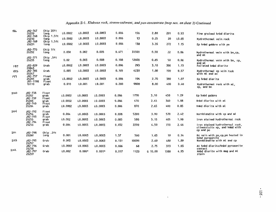
Appendix E-1. KIukwan rock, strearn-sediment, andpan-concentrate (map nos. on sheet 3)-Continued
582-767 Chip 2Oft 25229 long ~0.0002 L0.0003 L0.0003 0.006 156 2.80 201 0.53 Fine grained hnbd d i o r i t e 382-768 Chip 1.5f t 25230 l ong ~0.0002 L0.0003 L0.0003 0.006 13 0.25 20 L0.05 Hydrothermal ve in rock 582-769 Chip 1.5ft 2S231 ! oag L0.0002 LO.0003 L0.0003 0.006 138 3.35 272 1-15 Ep hnbd gsbbro u i t h po
J82-770 Chip lft 25232 ! nng 0.030 0.002 0.005 0.671 31500 0.50 22 0.06 Hydrothermal ve in u i t h bn,cp,
and rnl 582-771 Chip . 5 f t 25233 long 0.02 0.003 0.008 0.108 12600 0.65 50 0.06 Hydrothermal ve in wi th bn, cp,
and ml 582-829 Grab L0.0002 L0.0003 L0,0003 0.006 293 3.10 300 1.13 Fol ia ted hnbd d i o r i t e 20843 J82-785 Grab 0.005 L0.0003 L0.0003 0.105 4230 1-00 190 0.57 Hydrothermal ep ve in rock 2S247 w i th rnl and az 282-737 Float 25201 grab L0.0002 L0.0003 L0.0003 0.006 1 94 2.70 380 1.07 Ep hnbd d i o r i t e 581-1198 Float lDI1O greb 0.010 LO.OO1 LO.001 0.200 9800 8.00 400 0.40 Hydrothermal rock with rnl,
cp, and bn
382-736 Float 25202 grab L0.0002 L0.0003 L0.0003 0.006 1770 3.10 450 1.29 Ep hnbd gabbro J82-739 Float 2S203 grab iG.0002 10.0003 L0.0003 0.006 470 2.45 360 1.08 HnM d i o r i t e w i t h m l 582-740 Float 2S204 grab L0.0002 L0.0003 L0.0003 0.006 870 2.65 400 0.85 Hnbd d i o r i t e wi th ml
582-792 Float 25254 grab 0.004 $3.2-793 i i oat 2S255 grab L0.002 J82-794 F loat 2S256 grab 0.004
582-798 Chip . 2 f t 25260 long 0.001
582-795 Grab 0.303 2S257 582-796 Grab LO. 0002 25258 582-797 Grab LO. 002 25259
b0.0003 L0.0003 0.038 5200 3.90 570 2.42 Hornblendite wi th cp and m l
L0.0003 L0.0003 0.085 580 5.15 405 1.90 I r o n stained hydrothermal rock
i0.0003 i0.0003 0.032 2200 4.50 770 2.46 Iror: stained hhydrctherw! rock, c l i nozo is i te ep, and hnbd w i th CP and Po
L0.0003 L0.0003 1.37 560 1.65 19 0.14 Pz vein wi th py,cp,po hosted i n hnbd pyroxeni t e
L0.0003 L0.0003 0.131 10000 2.60 480 1-89 HcrnSLe.dite w i th m l e d cp
L0.0003 L0.0003 0.006 68 2.75 313 1.03 A t h n M dior i te/hnbd pyroxenite contect
0.000* 0.001* 0.017 1120 G 10.00 1580 4.95 HnW d i o r i t e w i th mag a d ml s t a i n
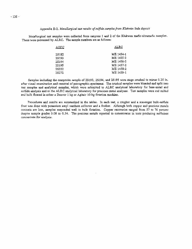
Appendix E-2. Metallurgical test results of supde samples porn Klukwan lode deposit
Metallurgical test samples were collected from canyons 1 and 2 of the Klukwan mafic-ultramafic complex. These were processed by ALRC. The sample numbers are as follows:
AOFC ALRC
Samples including the composite sample of 29193, 29194, and 25195 were stage crushed to minus 0.25 in. after visual examination and removal of petrographic specimens. The crushed samples were blended and split into test samples and analytical samples, which were submitted to ALRC analytical laboratory for base-metal and sulfide analysis and to the ALRC analytical laboratory for precious-metal analyses. Test samples were rod milled and bulk floated in either a Denver 1 kg or Agitair 10-kg flotation machine.
Procedures and results are summarized in the tables. In each test, a rougher and a scavenger bulk-sulfide float was done with potassium amyl xanthate collector and a frother. Although both copper and precious metals contents are low, samples responded well to bulk flotation. Copper recoveries ranged from 57 to 76 percent despite sample grades 0.08 to 0.34. The precious metals reported to concentrates in tests producing sufficient concentrate for analysis.
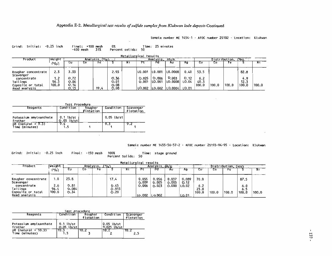
Samle nunber ME 1454-1 - AFOC n-r 2S132 - 'Locat ion: Klukuan
Grind: I n i t i a l : -0.25 inch Final: +I00 mesh 0% Time: 25 minutes -400 mesh 31% Percent so l ids: 50
Meta l lu rg ica l r e s u l t s
Test Procedure
-- -
Samole nunber ME 1455-56-57-2 - AFOC number 2S193-94-95 - Location: Klukwan
1 Analysis, o r l r .
Reagents Condi t i o n Rougher
Potassiun amylxanthate Frother
7:3:;::z>9-3)
Grind: I n i t i a l : -0.25 inch Final: -150 mesh 100% Time: stage ground Percent so l ids: 50
D is t r ibu t ion , .[o/ob. .
2.93
Condit ion
0.1 l b / s t 0.05 lb /s t 9.4
1.5
100.0
N i Cu
53.5
Scavenger . f l o t a t i o n .
Meta l lu rg ica l r e s u l t s
Co F e
F l o t a t i o n
1
Test procedure
0.025 0.001
LO.002
LO.001 Scavenger
concentrate 1 . 2 Ta i l i ngs 96.5
I I I
Product 1Uetght 1 Ana 1 ys i s . .(
Reagents Condi t i on Condition
Potassiun amylxanthate Frother
S
82.8
0.72 0.06 0.14 0.13
Coposi t e o r . t o t a l Head analysis
0.05 i b / s t l
Scavenger $ t o t e t i o n
0.006 LO.OO1
LO.002
P d
LO.001
N 1
100.0
9.3 1
Analysis, Ca/t C"/o)
I I I I
0.1 l b / s t O.Q5 Ib /s t
10.3 1.5
19.4
9.2 1
Ct!
23.8
0.81 0.084 0.34
Pt
0.055 0.009 0.006
LO. 002
D is t r ibu t ion . {o/o) .
Rougherconcentrate Scavenger
concentrate Ta i l i ngs Coposite o r t o t a l Head analys is
0.003 L0.0008
L0.0004
Au
h0.0008
0.36 0.01 0.08 0.08
Cu
70.0
6.2 23.8
100.0
1.0
2.6 96.4
100.0
10.2 3
Ag ------------ 0.40
Pd
0.056 0.005 0.023
L 0.002
N 1 Co Co
100.0
0.05 lb /s t 9 0 2 5 l b / s t
0.2 2
100.0
0.12 I 6.2 L0.04 40.3
Au
0.037 0.003 0.000
10.2 2.5
L0.01
F e A s
0.089 0.12
L0.02
L0.01
Fe
100.0
100.0
S
17.4
0.45 0.013 0.20
S
87.5
6.0 6.5
100.0
Ni
100.0
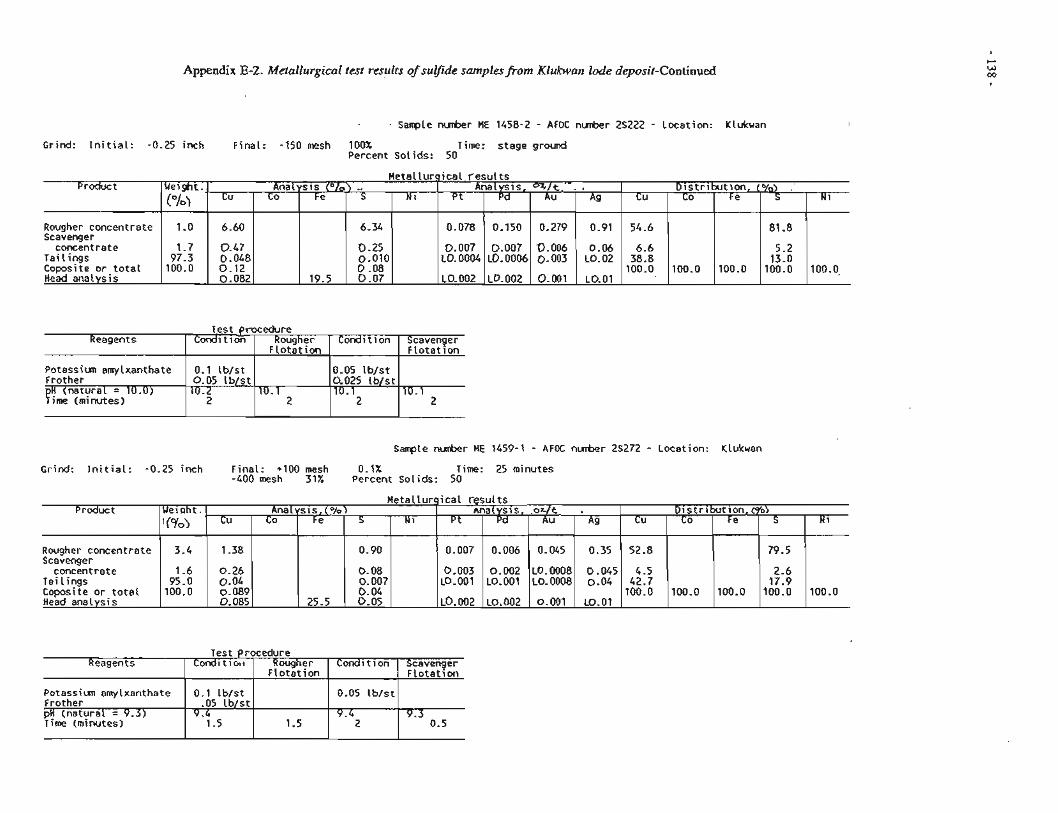
Appendix E-2. Metallurgical test results of sulfide samplesfiom Klukwan lode deposit-Continued
Sample nunber ME 1458-2 - AFOC nunber 25222 - Location: Klukwan
Grind: I n i t i a l : -0.25 inch Final: -150 mesh 100% Time: stage ground Percent Solids: 50
Metal lurg ica l r e s u l t s Product
Rougher concentrate Scavenger
concentrate Tai l ings Coposite o r t o t a l Head analysis
Test procedure
Sample nunber HE 1459-1 - AFOC nunber 25272 - Location: Klukwan
Reagents
Potassiun amylxanthate Frother
Y ~ ~ 2 Z ~ e i ~ 1 0 - 0 '
G r i n d : I n i t i a l : -0.25 inch Final: +I00 mesh 0.1% Time: 25 minutes -400 mesh 31% Percent Solids: 50
Cleight.
("10) 1.0
1.7 97.3 100.0
i 1 I I
Condition
0.1 Ib /s t 0.05 tb /s t 10.2
2
Test procedure Reagents Condi t i c n ~ Condit ion Scavenger
F lo ta t ion 1 I I I
Metal lurp ica l resu l t s
Analysis .. Analysis. %/t. .
Rougher F l o t a t i o n
10.1 2
Product
Rougher concentrate Scavenger
concentrate Tai l ings Coposite o r t o t a l Head analysis
D is t r ibu t ion , (%I '
Potassiun amylxanthate Frother pH (natural = 9.3) Time (minutes)
Ag
0.91
0.06 L0.02
L0.01
Cu
6.60
0.47 0.048 0.12 0.082
Pt
0.078
0.007 L0.0004
L0.002
Cu
54.6
6.6 38.8 100.0
Condit ion
0.05 l b / s t 0.025 l b / s t 10.1
2
S
6.34
0.25 0.010 0.08 0.07
Scavenger F lo ta t ion
10.1 2
Ueiqht .
'("lo)
3.4
1.6 95.0 100.0
0.1 l b /s t -05 l b / s t
9-4 1.5
N i Co Pd
0.150
0.007 L0.0006
L0.002
Co
100.0
Fe
19.5
Au
0.279
0.006 0.003
0.001
Analysis,(p/~) nnalysis. .or/t ,
1.5
Fe
100.0
Distr ibut ion,tgb) Cu
1.38
0.26 0.04 0.089 0.085
Pt
0.007
0.003 LO.001
~0.002
0.05 l b / s t
9.4 2
S
81 -8
5.2 13.0 100.0
Co Pd
0.006
0.002 LO.001
L0.002
Cu
52.8
4.5 42.7 100.0
9.3 0.5
Ii
100.0,
S
79.5
2.6 17.9 100.0
F e
25.5
Au
0.045
L0.0008 L0.0008
0.001
Co
100.0
N i
100.0
Ag
0.35
0.045 0.04
LO.O1
Fe
100.0
S
0.90
0.08 0.007 0.04 0.05
N 1
APPENDIX P. ANALYSES FROM TWELVlEkMILE GOLD- COPPEX PROSPECT
Appendix
F- 1
Title - Page
Analyses from Twelve-mile gold-copper prospect 140
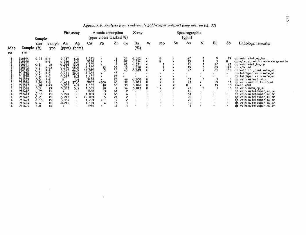
Appendix I;. Analysmfram Irivelve-mile gold-copper prospect (map nos. onfig.
Fire assay A t o m i c absorpt ion
S a m p l e (ppm unless m a r k e d %)
size S a m p l e AU Ag Cu Pb Zn Co Map Sample (ft) type ( P P ~ ) ( P P ~ ) w. no.
1 7S0594 0.05 R-S 0.137 6.6 1.35% N 2 31 2 750590 - R-5 0.068 2.5 5550 N 12 97 2 750591 0.8 CR 0.068 13.0 1.50% N 4 85 2 7S0592 0.2 R-CR 0.514 48.0 9.50% 15 58 18 2 750593 0.3 R-5 0.377 66.5 12.01% 5 10 43 2 7U1718 0.3 R - C 0.411 29.0 4.60% N 10 - 2 7U1719 0.6 R-C 0.377 8.3 1.40% N 24 - 3 750595 0.3 R-S N 1.4 3450 N 26 46 3 750596 0.05 R-5 0.651 37.0 9002 4800 66 32 3 750597 0.07 R-CR 0.308 4.9 1.10X 10 50 33 4 750598 0.3 CR 0.343 5.5 1.552 20 4 54 4 750620 0.75 CH N 1600 3 61 2 4 750621 0.15 CH 0.274 - 1.00% 3 66 6 4 750622 0 . 2 CH 0.240 - >2.00% 5 21 2 4 7S0623 0.15 CH 0.137 - 1.70% N 17 2 4 750624 0.4 CH 0.240 - 1-15% 4 13 1 4 750625 1.0 CH N 1950 N 11 1
X-ray Spectrographic
( P P ~ ) W Mo Sn As Ni Sb Lithology, r e m a r k s
qz vein w/ml az,bn qz u/kr,cp,m[, hornblende granite qz vein u/ml,bn,cp qz u/bn,ml qz vein i n jo int w/bn,ml qz-feldspar vein w/bn,ml qz-feldspar vein u/bn,ml qz vein u/fest,ml,cp qz vein u/diorite,cp,ml shear u/ml qz vein w/bn cp,ml qz vein u/fe[dspar,ml,bn qz vein u/feldspar,ml,bn qz vein w/feldspar,ml,bn qz vein u/feldspar,ml,bn qz vein u/feldspar,ml,bn qz vein u/feldspar,ml,bn
APPENDM 6. ANALYSES FROM CHILKAT PENINSULA AND ISLANDS BASALT-HOSTED PROSPECTS AND
OCCURRENCES
Appendix Title Page
G- 1 Analyses from Road Cut prospect mrface .............................. . . . . . . samples .... 142
G-2 Analytical results from DDHl and DDH3 .......... 144 G-3 Analyses from Road Cut I1 prospect ................. 145
......................... (3-4 AnalysesfromChilkatIdands 146
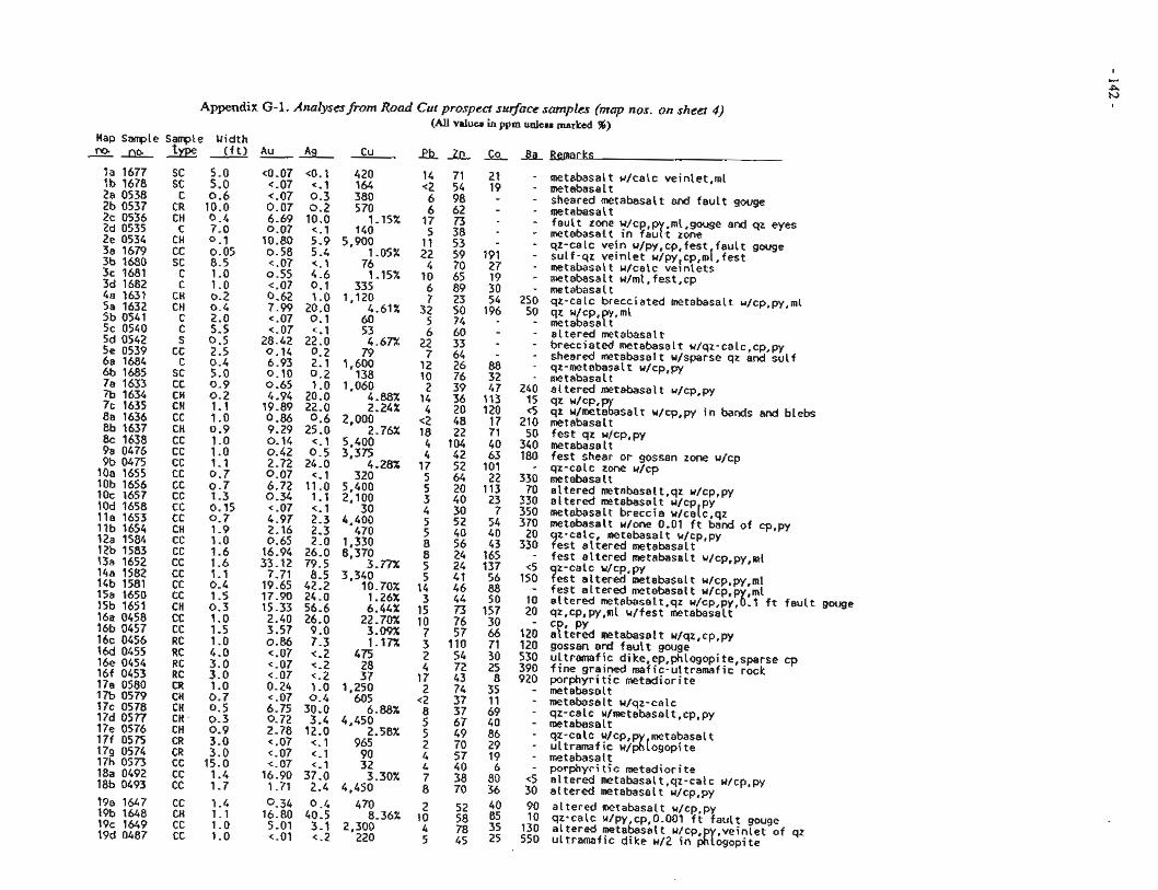
A p p d i x G-1. Analyses from Road Cut prospea surface samples (map nos. on sheet 4) (All valuer in ppm unlerr marked 96)
Hap Sample 2 J K L
la 1677 lb 1678 2a 0538 2b 0537 2c 0536 2d 0535 2e 0534 3a 1679 3b 1680 3c 1681 3d 1682 4a 1631 5a 1632 5b 0541 5c 0540 5d 0542 5e 0539 6a 1684 6b 1685 7a 1633 7b 1634 7c 1635 8a 1636 8b 1637 8c 1638 9a 0476 9b 0475 10a 1655 10b 1656 1Oc 1657 1Od 1658 lla 1653 llb 1654 12a 1584 12b 1583 13a 1652 14a 1582 14b 1581 15a 1650 15b 1651 16a 0458 16b 0457 16c 0456 16d 0455 16e 0454 16f 0453 176 0580 1% 0579 17c 0578 17d 0577 17e 0576 17f 0575 17s 0574 17h 0573 18a 0492 18b 0493
Sarrple Width type (ft) Au Ag Cu & A L Co &Bemarks
metabasalt u/calc veinlet,ml metabasal t sheared metabasalt and fault gouge metabasalt fault zone u/cp,p ,ml,gouge and qz eyes metabasal t in faurt zone qz-calc vein u/py,cp,fest fault gouge sulf-qz veinlet u/py,cp,m[,fest metabasalt u/calc veinlets metabasal t w/ml, fest,cp metabasalt qz-calc brecciated metabasalt u/cp,py,ml qz Wcp, y.ml metabasart altered metabasatt brecciated metabasalt u/qz-calc,cp,py sheared metabasalt w/sparse qz and sulf qz-metabasal t w/cp,py metabasal t altered metabasalt w/cp,py qz W/CP, qz u/met%asalt u/cp,py in bands and blebs metabaselt fest qz ulcp,p~ metabasalt fest shear or gossan zone u/cp qz-calc zone u/cp metabasalt altered metabasait,qz u/cp,py altered metebasalt w/cp py metabasatt breccia ~/ca[c,~z metabasalt w/one 0.01 ft band of cp,py
9 z-calc, metabasalt w/cp,py est altered metabasalt fest altered metabasalt u/cp,py,ml z-calc u/cp,py
Test altered metebasalt u/cp,py,ml fest altered metabasalt w/cp,p ,ml altered metabasalt,qz w/~~,~y,8.l ft fault gouge qz,cp,py,ml u/fest metebasalt C ariered PY metabasal t w/qz,cp,py
gossan and fault gouge ultramafic dike,ep,phlogopite,sparse cp fine grained mafic-u!tramafic rock porphyritic metadior~te metebasalt metabasalt w/qz-calc qz-calc w/metabasalt,cp,py metabasalt qz-calc w/cp,p metabasalt ultramaf ic u/&[ogopi te metabasalt porphyritic metadiorite altered metabasalt,qz-calc w/cp,py altered metabasalt w/cp,py
90 altered metabasalt w/cp,py 10 qz-calc w/py,cp,0.001 ft fault gouge 130 altered metabasalt u/cp veinlet of qz 550 ultramafic dike w/Z in $r6gopite
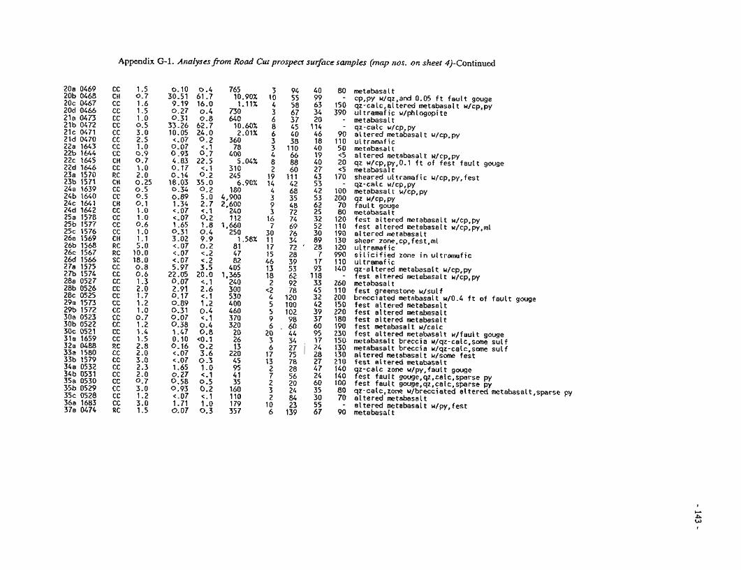
Appendix G-1. AnrsEysesJ?om Road CUS prosped sujircc samples (map nos. on sheer 4)-Continued
metabasatt cp,py u/qz,and 0.05 f t f a u l t gouge qz-caic,ai tered metabasait w/cp,py u l t ramaf ic u/phlogopite metabasal t qz-caic u/cp,py a l t e r e d metabasalt u/cp,py u l t ramaf ic mtabasai t a l t e r e d metabasal t u/cp,py qz r/cp,py,0.1 f t o f f e s t f a u l t gouge metabasai t sheared u l t r a ~ f i c w/cp,py,fest qz-calc u/cp,py metabasalt u/cp,py
9 z ~/CP,PY au l t gouge
metabasal t fes t a l te red metabasalt u/cp,py fest e l tered metabasalt u/cp,py,ml a i te red metabasalt shear zone,cp.fest,ml ul tramaf i c s i l i c i f i e d zone i n u l t ramaf i c ul tramaf i c
9 z -a l te red metabasalt u/cp,py est a l te red metabasalt w/cp,py
metabasal t f e s t greenstone w/sulf brecclated metebesalt W0.4 f t o f f a u l t gouge t e s t a l te red metabaselt fest a l te red metabasalt f e s t a t tered metabasait f e s t metabasalt w/calc fes t a l te red metebasalt u / f a u i t gouge metabasait brecc ia u/qz-calc,scm s u l f metabasalt brecc ia w/qz-calc,some s u l f a l t e r e d metabasalt w / s m f e s t f e s t e i te red m t a b a s a i t
9 z-calc zone w/py,fault gouge est f a u l t gouge,qz.calc,sparse py
f e s t f a u l t gouge,qz,calc,sparse py qz-calc,zone u/brecciated a l t e r e d metabasalt,sparse a l t e r e d metabasalt a l t e r e d metabasalt u/py, f e s t metabasal t
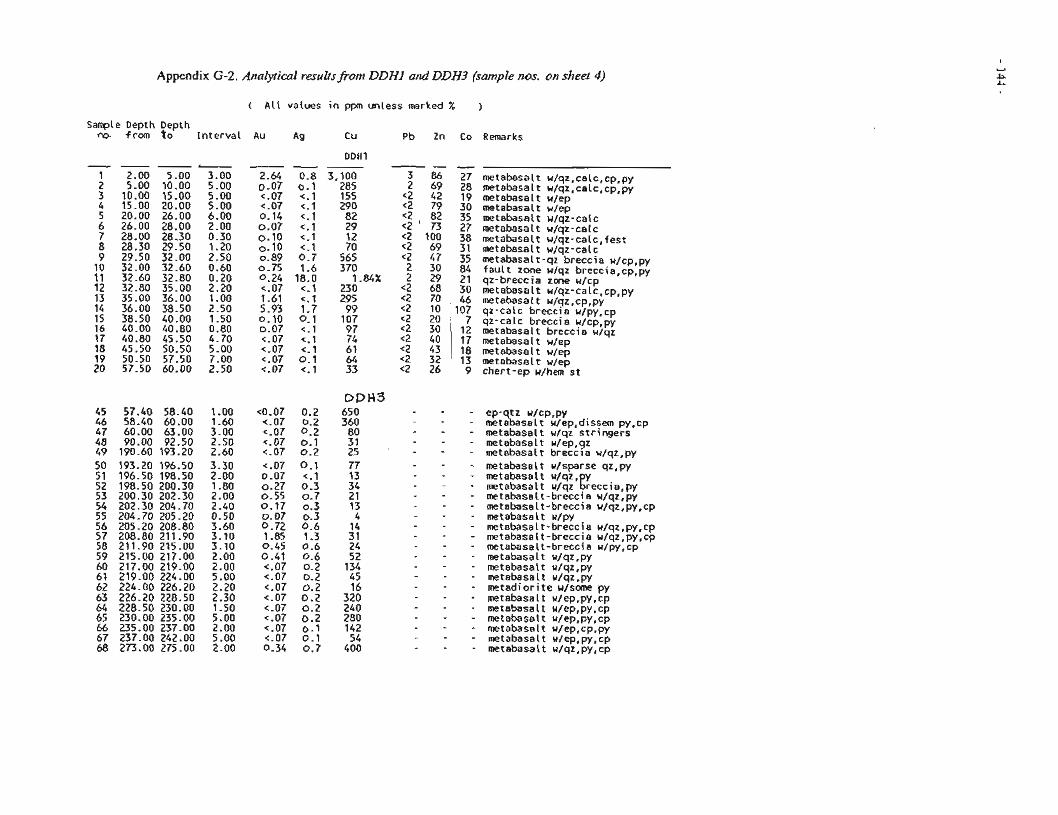
Appendix G-2. Analytical resultsfrom DDHl and DDH3 (sample nos. on sheet 4)
( A l l values i n ppm unless marked % )
.e Depth Depth f rom t o I n t e r v a l Au Ag C u Pb Zn Co Remarks
--- 3 86 27 metabasalt w/qz,calc,cp,py 2 69 28 metabasalt w/qz,calc,cp,py
~2 42 19 metabasalt wlep 2 79 30 metabasalt w/ep <2 82 35 metabasalt wlqz-calc 2 73 27 metabasalt w/qz-calc <2 100 38 metabasalt w/qz-calc,fest <2 69 31 metabasalt w/qz-calc <2 47 35 metabasalt-qz brecc ia w/cp,py 2 30 84 f a u l t zone u lqz breccia,cp,py 2 29 21 qz-breccia zone wlcp
<2 68 30 metabasalt w/qz-calc,cp,py <2 70 46 metabasalt u/qz,cp,py <2 10 107 qz-ca lc brecc ia u/py,cp
7 qz-ca lc brecc ia w/cp,py 12 metabasalt brecc ia u/qz 17 metabasalt w/ep 18 metabasalt w/ep 13 metabasa l tu lep
<2 26 9 cher t -ep w/hem s t
ep-qtz ~/CP,PY metabasalt u/ep,dissem py,cp metabasalt w/qz s t r i n g e r s metabasalt w/ep qz metabasal t b r e c l i a w/qz,py metabasalt u/sparse qz,py metabasalt w/qz, y metabasal t u/qz greccia,py metabasalt-breccia w/qz,py metabasalt-breccia w/qz,py,cp metabasa l t u/py metabasalt-breccia w/qz,py,cp metabasalt-breccia u/qz,py,cp metabasalt-breccia u/py,cp metabasalt u/qz,py metabasalt u/qz,py metabasalt u/qz,py metad io r i te u / s m py metabasalt u/ep,py,cp metabasalt u/ep,py,cp metabasalt u/ep,py,cp metabasalt u/ep,cp,py metabasalt u/ep,py,cp metabasal t u/qz,py,cp
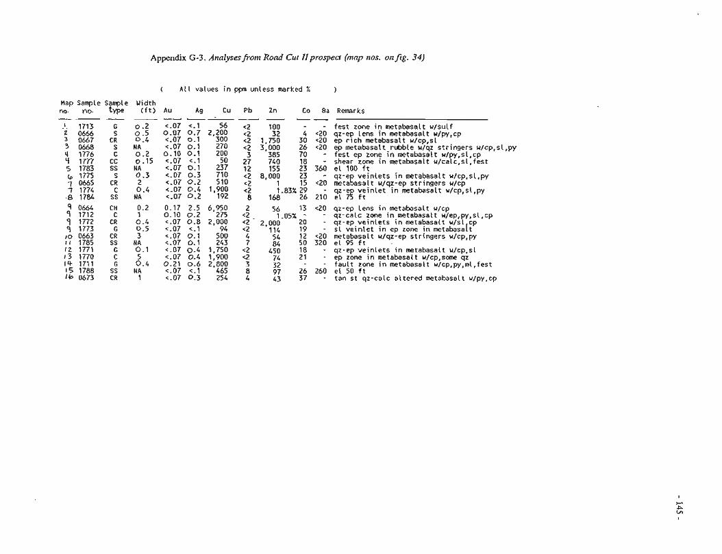
Appendix G-3. Annlysesfrom R o d Cur IIprospecl (mnp nos. onfig. 34)
( A t l values i n ppm unless marked % 1
Hap Sample Sampte Width no. no. type ( f t ) AU Ag Cu Pb Zn Co Ba Remarks _ . - - J - - -- ! 1713 6 0.2 <-07 c.1 56 <2 100 - f e s t zone i n metabasalt u /su l f 23 0666 S 0.5 0 . 0 7 0 . 7 2.200 <2 32 4 <20 qz-ep Lens in metabasalt u/py,cp
0667 CR 0.4 <.07 0- j 300 <2 1,750 30 <20 e p r i c h m e t a b a s a l t u / c p , s l 3 0668 S NA c.07 0.1 270 <2 3,000 26 <20 ep metabasalt rubble w/qz s t r ingers w/cp,sl ,py 4 1776 C 0 . 2 0 . 1 0 Q . l 200 3 385 70 - fes tepzoneinmetabasa l tu /py ,s l ,cp '-1 1777 CC 0.15 c.07 < . I 50 27 740 18 - shear zone i n metabasalt u/calc,sl,fest 5 1783 SS NA < . 0 7 0 . l 237 12 155 23 360 e l 1 0 0 f t b 1775 S 0.3 <-07 0.3 710 <2 8,000 23 - qz-e v e i n l e t s i n metabasalt w/cp,sl,py 7 0665 CR 2 c.07 0 . 2 510 <2 1 15 <2O rnetagasalt w/qz-ep s t r ingers w/cp f 1774 c 0.6 <.07 0 . 4 1,900 <2 1.83% 29 - qz-e v e i n l e t i n metabasalt w/cp,sl,py 8 1 7 8 4 SS NA <.07 0 .2 192 8 168 26 210 e l 75 C t
q 0664 CH 0.2 0.17 2.5 6,950 2 56 13 <20 qz-ep Lens in metabasalt u/cp 9 1712 C 1 0 . 1 0 0 . 2 275 <2 1.05% - - qz-calc zone i n metabasalt u/ep,py,sl,cp p 1772 CR 0.4 c.07 0.8 2,000 <2 - 2,000 20 - qz-ep v e i n l e t s i n metabasalt w/sl cp 9 1773 G 0 . 5 q.07 <.I 94 <2 114 19 - s l v e i n l e t i n ep zone i n metabasalt lo 0663 CR 3 c . 0 7 0 . 1 500 4 54 12 <20 metabasalt w/qz-ep s t r ingers w/cp,py r ; 1785 SS HA c . 0 7 0 . 1 243 7 84 50 320 e i 9 5 f i I 2 1771 G 0 . 1 <.07 0.4 1,750 <2 450 18 - qz-ep v e i n l e t s i n metabasalt w/cp,sl 1 3 1 7 7 0 C 5 c.07 0.4 1,900 <2 74 21 - epzoneinmetabasaltw/cp,someqz i + 17i1 G 0 . 4 0.21 0 . 6 2,800 3 32 - f a u l t zone in metabasalt u/cp,py,mi,fest 15 1788 SS NA c.07 <.I 465 8 97 26 260 e l 50 d t Ib 0673 CR 1 < - 0 7 0 - 3 254 4 43 37 - tan st qz-calc a l t e r e d metabasalt u/py,cp
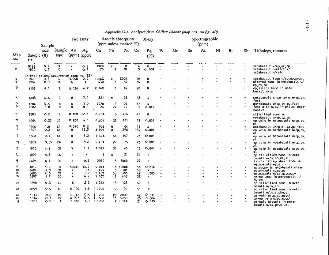
Appendix G-4. Analyses/i.om Chilkar Islands (map nos. on fig. 40)
Fire assay Atomic absorption X-ray Spectrographic
Sample (ppm unless marked %) ( P P ~ ) size Sample Au Ag Cu Pb Zn Co Ba W Mo Sn As Ni
Sample Cft) type O m ) ( P P ~ ) no.
(%I - - - - ---- - - - -
0428 0.5 S N 0.2 1920 N 8 4 N 1800 9 . 3 C N 0.1 70 3 38 5 0 .068 -
Lithology, remarks
metabasalt u/ep,qz,cp metabasalt contact u/ metabasalt w/calc
Shikosi I s land Occurrence (map No. 52) 1820 0.5 G 0.050 2.4 1.06% N 3000 18 N 1902 8.0 CR N N 430 2 24 34 N
metabasalt f low u/cp ep, y,ml a l t e r e d zone in metabesaft w/ cP,Py ep,sl I ica band i n meta- basa l t u/cp
metabasalt shear zone w/ep,py. f e s t metabasalt w/ep,cp,pr[fest f e s t d i ke w/py i n p i ow meta- basal t s i l i c i f i e d zone in metabasal t w/ep,cp,py e v e i n in metabasalt w/cp,py, mi' metabasalt w/ep,ml,cp,py,fest ep v e i n in metabasalt u/cp,py, ml ep v e i n i n metabasalt w/cp,py, ml ep v e i n in metabasalt w/cp,py, ml ep v e i n in metabasalt u/cp,py, ml ep s i l i c i f i e d zone i n meta- basal t u/py,cp,ml,sl s i l i c i f i e d ep shear zone i n metabasalt u/py,cp ep,c ,py i n metabasalt shear metsgasalt w/ep,py metabasal t u/ep,qz,cp, a z - e ~ lens i n metabasaK u/ PY. cb ep s i l i c i f i e d zone in meta- basal t w/py ,cp ep s i l i c i f i e d zone i n meta- basal t u/py,cp,bn,sI qz v e i n u/ep,cp,py,sl qz-ep v e i n u/py,cp,sl qz-calc breccia i n meta- basal t u/cp,py,sl,ml
APPENDIX H. ANA1,YTICAL RESULTS ]FROM PORCUPINE PLACER: DEPOSITS
Appendix Title Page
H-1 Trace element and gold fineness of placer gold from the Porcupine area. ............................ 148
H-2 Mineral identification of selected pan concentrates and placer samples from the Porcupine area.. ...................................... 149
H-3 R m t s of reconnaissance and channel placer sampling in the Porcupine area .................... 150
R-4 Results of site-specific bulkplacer samples collected from lower Porcupine Creek. ........... 156
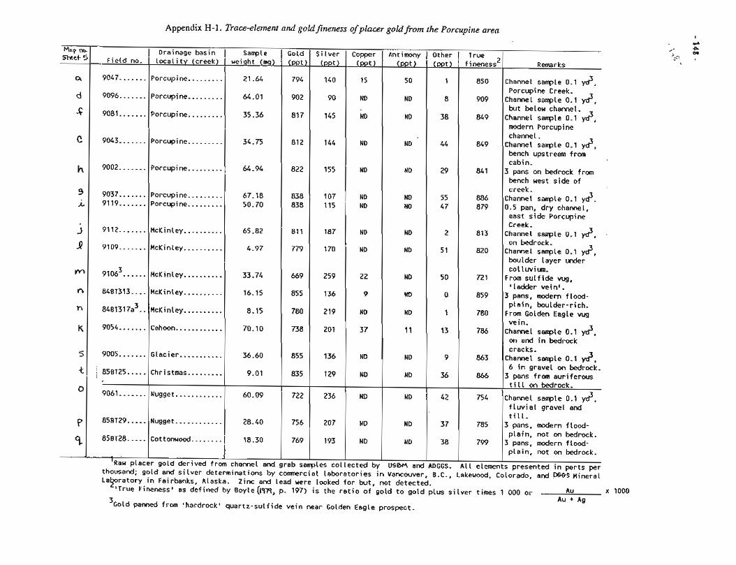
Appendix H-1. Trace-element and goldfineness of placer goldfrom the Porcupine area
old panned from 'hardrock' quartz-sulfide vein near Golden Eagle prospect.
Remarks
Channel sampleO.l y d , Porcupine Creek. Channel sample 0.1 y d , but below charnel. Channel sample 0.1 y d , modern Porcupine channel. Channel sample 0.1 y d , bench upstream from cabin. 3 pans on bedrock from bench west side of creek. Channel sample 0.1 yd. 0.5 pan, dry channel, east side Porcupine Creek. Channel sample 0.1 y d , on bedrock. Channel sample 0.1 y d , boulder layer under collwiun. Frmsulfidewg, 'ladder veino.
3 pans, d e r n flood- plain, boulder-rich. From Golden Eagle vug vein. Channel sample 0.1 2, on and in bedrock cracks. Channel semple 0.1 yd3, 6 in gravel on bedrock. 3 pans from auriferous till on bedrock.
Channel sample 0.1 y d , flwial gravel and till. 3 pans, modern flood- plain, not on bedrock. 3 pans, modern flood- plain, not on bedrock.
presented in parts per Colorado, and Mineral
La ratory in Fairbanks, ALaska. Zinc and lead uere looked for but, not detected. $True FinenessB as defined by 8oyle(ly~, p. 197) is the ratio of gold to gold plus silver times 1 000 or
Au Au + Ag x 1000
-
) Field no. --
Silver (ppt)
Drainage basin I locality (creek)
Antimony (ppt)
Copper (ppt)
50
ND
ND
ND
ND
ND ND
ND
ND
ND
ND
UD
11
ID
ND
UD
ND
ND
USbM and in Vancouver,
15
ND
ND
9047 ....... ....... 9096
9081 .......
9043 .......
Sample 1 weight (mg)
Other (ppt)
Gold (ppt)
True fineness 2
1
8
38
44
29
55 47
2
51
50
0
1
13
9
36
42
37
38
ADGGS. B.C.,
9002 .......
9037 ....... 9119 .......
9112.......
9109 .......
9106~. ..... 8487313 .... 848~317a~. .
9054 .......
9005 ....... : 85BT25 .....
9061 .......
858129 ..... 85BT28 .....
- - ' ~ a u placer
thousand;
......... Porcupine
......... Porcupine
Porcupine .........
Porcupine .........
850
909
849
849
841
886 879
813
820
721
859
780
786
863
866
754
785
799
All elements Lakeuood,
Porcupine .........
I Porcupine ......... Porcupine .........
McKinley .......... McKinley ..........
McKinley .......... McKinley .......... McKinley.. ........ Cahoon ............
Glacier ........... Christmas .........
Nugget ............
Nugget ............ Cottonuood ........
21.64
64.01
35.36
34.75
64.94
67.18 50.70
65.82
4.97
33.74
16.15
8.15
70.10
36.60
9.01
60.09
28.40
I 1 18.30
794
902
817
I gold derived from channel and
gold and silver determinations by
140
90
145
grab samples collected by comnercial laboratories
822
838 838
811
779
669
855
780
738
855
835
722
756
769
li4 I 155
107 115
187
170
259
136
219
201
136
129
236
207
193
ND
ND ND
ND
ND
22
9
ND
37
ND
NO
ND
ND
ND
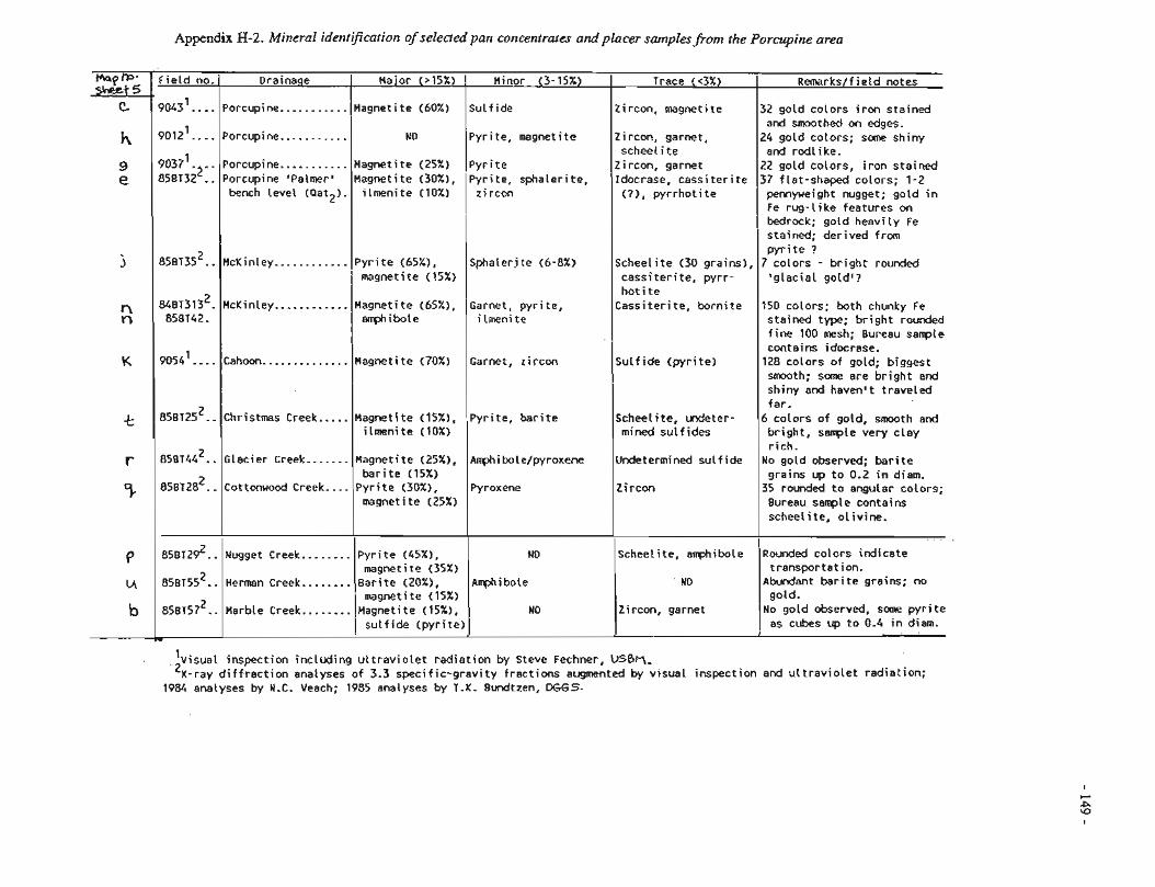
Apgendix H-2. Mineral identification of selected pan concentrates and placer samplesfrom the Porcupine area
Field no. 1 Drainage I Haior (>IS%) I Minor (3- 15%) I I
9043'. . . . IPorcupine.. . . . . . . . . . /Magnetite (60%) I Sulfide 9012'. . . . IPorcupine.. . . . . . . . . . i ND IPyrite, magnetite
Trace ( ~ 3 % ) I Remarks/field notes
9037' 858~3;~: :
Zircon, magnetite
Zircon, garnet, scheel i te Zircon, garnet Idocrase, cassiterite (?), pyrrhoti te
I
1 I
32 gold colors iron stained and smoothed on edges.
24 gold colors; some shiny end r d l i ke. 22 gotd colors, iron stained 37 flat-shaped colors; 1-2 pennyweight nugget; gold in Fe rug-like features on bedrock; goid heaviiy i e stained; derived from
Porcupine.. . . . . . . . . . Porcupine 'Palmers bench level (Pat2)-
I I I I pyrite ? 8 5 ~ ~ 3 5 ~ . . I ~ c ~ i n l e ~ ............ Pyrite (65x1, (~phalerite (6-8%) IScheelite (30 grains), 7 colors - bright rounded
Magnetite (25%) )pyrite Magnetite (30%), 1~yri te, sphaleri te, ilmenite (10%) zircon
I I magnetite (15%) I I cassiterite, pyrr- I 'glacial gold*?
'visual inspection including ultraviolet radiation by Steve Fechner, VSBt-I, 'x-ray diffraction analyses of 3.3 specific-gravity fractions augmented by visual inspection and uttraviolet radiation;
1984 analyses by N.C. Veach; 1985 analyses by T.K. Bundtzen, DGGS-
2 84BT313 . 85BT42.
9054'. . . .
8 5 ~ ~ 2 5 ~ . .
8 5 8 ~ 4 4 ~ . . 8 5 ~ ~ 2 8 ~ . -
85~?29~..
8 5 8 ~ 5 5 ~ . . 2 858157 ..
I Garnet, pyrite, i lmeni te
Garnet, zircon
Pyrite, barite
Amphibole/pyroxene
Pyroxene
49
Amphibole
McKinley ............
Cahoon.. . . . . . . . . . . . .
Christmas Creek.. . . .
Glacier Creek.. . . . . .
Cottonwood Creek. .. .
Magnetite (65"/.), a m i b o t e
Magnetite (70%)
Magnetite (IS%), ilmeni te (10%)
Magnetite (25x1, barite (15%)
Pyrite !30%!, magnetite (25%)
Rot i te Cassiterite, bornite
Sulfide (pyrite]
Scheelite, urdeter- mined sulfides
Undetermined sulfide
Z i rcon
Scheelite, amlbole
ND
!!usget Creek ........ Pyrite (45X!, 1 reikti te (35x1 Herman Creek.. . . . . . . Barite (20%),
magnetite (15%) Marble Creek ........
150 colors; both chunky Fe steined type; bright rounded fine 100 mesh; Bureau sample contains idocrase. 128 colors of gold; biggest smooth; some are bright end shiny and haven't traveied far. 6 colors of gold, smooth and bright, sample very clay rich.
No goId observed; barite grains up to 0.2 in diem.
35 rcuded to engi;!er colors; Bureau sample contains scheeiite, olivine.
R o u ~ e d colors indicate transportation.
Abundant bari te greins; no gold.
Zircon, garnet Magnetite (15X), I ND sulfide (pyrite) 1
No gold observed, some pyrite I as cubes up to C.4 in diem.
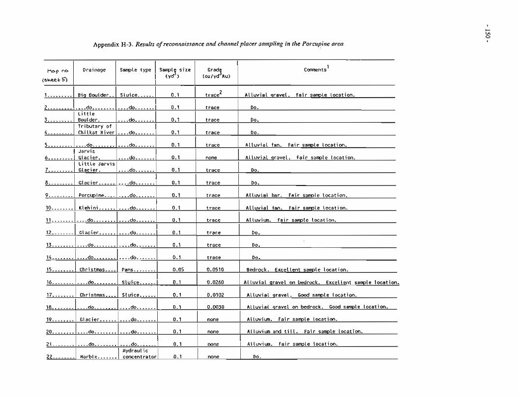
Appendix H-3. Results of reconnaissance and channel placer sampling in the Porcupine a r m
,, Drainage 1 a t Sanpl s i z e
(sheet 9 I 1 ($1 1 (o:>;$Au> 1
1 .........
2 ............. 3 .........
4 .........
Big Boulder..
5 .............
do ............ L i t t l e Boulder. Tr ibutary o f Chi lkat River
8 .........
9.. ....... 10 ........
Slu ice ......
do ............
1 1 ............ do ............
Glacier .......... Porcupine ........
Klehin i ..........
do .......
do. ...... I Jarvis
do ....... 12 ........ 13 ............
14 ............
15 ........
16 ............
17... ..... la....
19 ........ 20 ............ 21 ............ 22 ........
A l l u v i a l gravel. Fa i r sample locat ion. 0.1
t race
t race
t race
0.1
I I I I I
6 .........
7 .........
trace
t race
t race
0.0510
0.0260
0.0102
0.0030
none
none
t race 2
Do.
Do.
Do.
0.1
.... do ....... Glacier. L i t t l e Ja rv is Glacier.
do ....... do .......
0.1 t race
Glacier .......... do ............ do ............
Christmas .... do ........
Christmas .... ........ do ............
Glacier .......... do....
Do.
Do.
Do.
Bedrock. Excel lent sample locat ion.
A l l u v i a l gravel on bedrock. Excel lent sample locat ion.
A l l w i a l gravel. Good sarrple locat ion.
A l l u v i a l gravel on bedrock. Good sample Location.
Al luviun. F a i r sample locat ion.
A l luv iun and t i l l . F a i r sample location.
do ............ Marble.......
I
none
t race
0.1
I I
t race
t race
t race
0.1
0.1
Alluviun. Fa i r sample locat ion.
.... do .......
A l l u v i a l qravel. Fa i r s a m l e locat ion.
Do.
t race
Do.
A l l u v i a l bar. Fa i r sample locat ion.
A l l u v i a l fan. Fa i r sanple locat ion. do ....... 1 0.1 I
do .......
0.1
A l l u v i a l fan. Fa i r sample locat ion.
I
0.1
none I
Alluviun. F a i r sample locat ion.
none Do.
do .......
do 1 I
0.1 .... .......
.... do .......
0.1
0.1
I
do ....... do .......
Pans ........
I
0.1
0.1
0.05
Hydraulic concentrator 0.1
Slu ice ...... 0.1 I
Slu ice ...... do ....... do .......
........ do .......
0.1
0.1
0.1
0.1
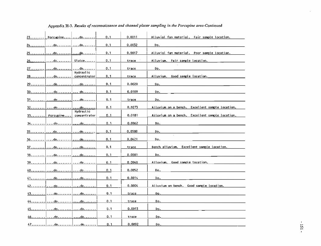
Appendix H-3. Results of reconnaissance and channel placer sampling in the Porcupine area-Continued
23 ........
24 ............
25 ............
26....
27 ............ 28 ............
I 1 I I I
Porcupine
do ............
29. ...........
do ............ do ........
30 ............ 31 ............
I ........ do ....... 1 0.1 I
....... do / 0.1
do ............
32 ............ 33 ........
I
do ....... Hydraul i c concentrator
I do ........... do........
34 ............
I
I I I do ....... 0.1
I
i I
do ........ l . . . .doOOOOO.. 0.1
.... Porcupine concentrator 0.1
0.0011
0.0032
1 A l l u v i a l fan material . Poor samle locat ion. do
0.1
0.1
0.0020 I Do.
I I I
do ....... .... do .......
do ............ Do.
A l l u v i a l fan material . Fa i r sample locat ion.
Do.
I 0.1
I 1 0.0017
1 ............ ........ dc ........ Sluice ...... 0.1 1 t r ace LIIWIYI. F a i r sanp!e locat ion.
do .......
0.0273 1 ALLlrvilm cn e bnch . Excel lent s a m l e Locetion.
0.0580 35 ............
trace
t race
0.1
0.1
0.0181
....... do
36 ............ 37 ............ 38... .........
trace 43........
Do.
Al luviun. Good sample Location.
A l luv iun on a bench. Excel lent sample Location.
do ............
Do. do ....... .... do ............ trace
0.0013
t race
do....... I
0.5
....... .,..do 0.1
.... do ....... 0.1
44......
............ 45
46 ............ 47 ............
0.0109
t race
0.1
do ............
do ............ do ............
0.1
Do.
Do.
Do.
...... do ............ ........ do
do........
do ............
Do.
Do.
do .......
Do.
0.0062
0.1
do ....... do ....... do .......
I 39 ............. do ........ I
0.0092 do.......
Do.
.... do .......
40 ............
41 ............
0.1
I I
do ............
do.. ..........
0.1 I
0.1
0.1
I 42 ........ !....do........
0.0040 A l l u v i w . Good s a m l e locat ion.
0.0421 Do.
I
Do.
Do.
A l l u v i u n on bench. Good sample locat ion.
do .......
trace
0.0052
Bench a l luv iun. Excel lent sample locat ion.
Do. 0.1
I 0.1
I
do ....... 0.1 0.0014
.... .... do... 0.1 1 0.0004 I
0.008i I
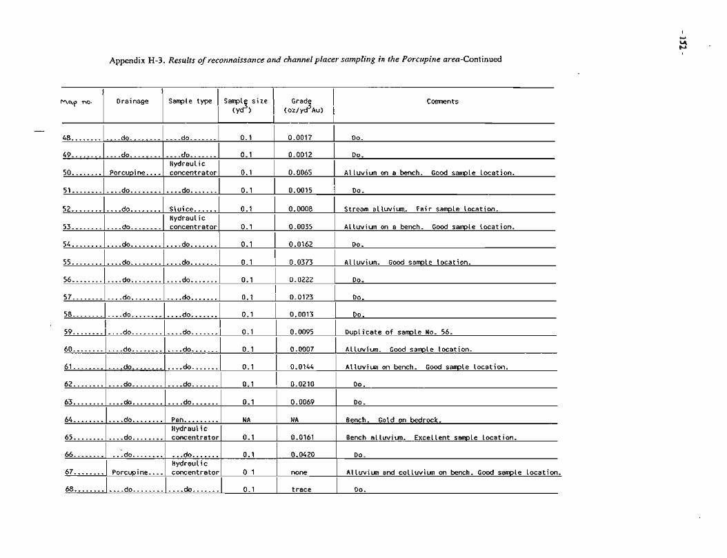
Appendix H-3. Results of reconnaissance arld chatinel placer sampling in the Porcupirie area-Continued
Comnents F R ~ a raina age ~ a o l e type / i anp l3 s i ze
I (yd )
Grad3 I (oz/yd Au) I
I I I
51 ........ [....do........l....do.......l 0.1 1 0.0015 I Do.
I
49 ............ 50 ........
.- 48 ............
I I I
54 ........ 1 .... do ........ I....do....... 1 0.1 1 0.0162 I Do.
I I I I I
do....... ..... do ....... do ............
Porcupine ....
52 ............
53 ............
I
I
0.1
I I I
do ....... Hydraul ic concentrator
I I I I I
do ........ do ........
55 ............ 56 ............
I I 0.0017
0.1
0.1
Slu ice ...... Hydraul ic concentrator
I I I I I
do ............ do........
57 ............ 58 ............
61 ............
Do.
do.......
.... do..... .. do ............ do........
0.0012
0.0065
0.1
0.1
do .......
.... do .......
I 59........(....do..--a-m.
do....
............ 62
68 ........ 1 .... do ........I.... do ....... I 0.1 I t race 1 Do.
Do.
A l luv iun on a bench. Good sample locat ion.
............ do ....... do
64 ............ 65 ............
0.0008
0.0035
Do.
Do.
.... do .......I I 0.0095 I
0.1 I
0.1
0.1
NA
0.1
Stream al luviun. Fa i r sarrple locat ion.
A l luv iun on a bench. Good sample locat ion.
Al iuviun. Good s a m l e locat ion.
Do.
0.1
0.1
Dupl icate of sample No. 56.
0.0123
0.0013
........ do ....... 0.1
do ........ do ........
do ....... Hydraul ic concentrator
0.1
0 1
........... 66
67 ........
0.0373
0.0222
0.0144 0.1
N A
0.0161
Pan......... Hydraul ic concentrator
I I I
do.. ......... Porcupine ....
Al luv iun on bench. Good sanple locat ion.
0.0210
Bench. Gold on bedrock.
Bench a l luv iun. Excel lent s a w l e Location.
I
0.0420
none
Do.
Do.
A l luv iun and c o l l u v i u n on bench. Good sample Locatiwr.
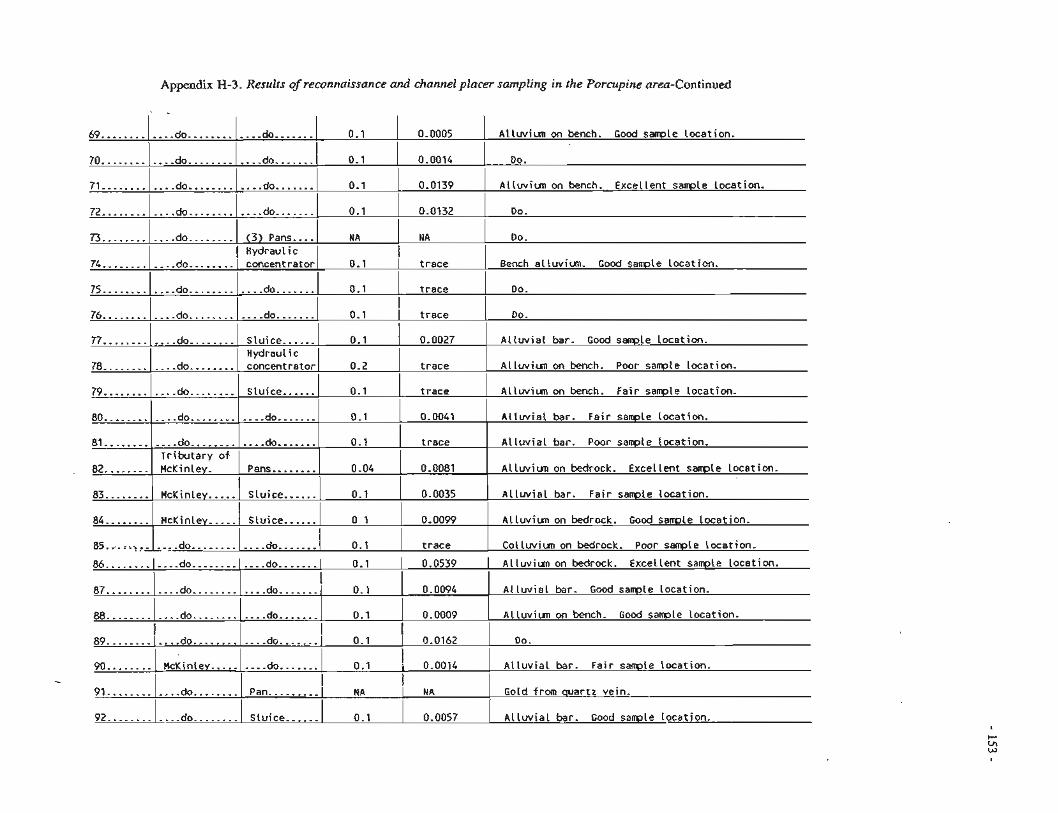
Appendix H-3. Resuits of reconnaissance and channel placer sampling in fhe Porcupine area-Continued
69 ............ 70 ............ 71 ............
72 ............ I . I x.. . . . . . . .... ao . . . . . . . . I (3) Pans.... I NA NA
I
0.0005 0.1
0.1
do ............ do ............
Alluvim on bench. Good sample location. ....... do
do .......
Do.
Bench al!uvim. Gcod samp!e tocation.
Do.
Do.
Alluvial bar. Good sample location.
Alluviun on bench. Poor sample location.
74 ............
75 ............
76 ............ 77 ............
0.0014
0.1
0.1
I
I Hydraulic do ........ [ concentrator I 0.1 trace
I
Do.
do ............
79 ............ 80... .........
81........
82 ........
83 ........
84 ........
do .......
trace
0.1
0.1
0.1
0.04
0.1
0 1
0.1
0.0139
I do ........ l....do.......
0.1
Hydraulic concentrator
do ............
0.2 I
78 ............
do ........ do ............
.... do ............ Tributary of HcKinley.
McKinley ..... McKinley .....
85...ez.,,,.,ldo........
ALluviun on bench. Excellent sample location.
do .......
trace do ........
86 ............
87 ............ 88 ............
I . Sluice......
do .......
do ....... Pans........
Sluice ...... ...... Sluice
.... ....... do
trace I
Alluviun on bench. Fair sample location.
0.0041 Alluvial bar. Fair sample location.
trace Alluvial bar. Poor sarrple location.
0 -0081 Allwiun on bedrock. Excellent sawle location.
0.0035 Alluvial bar. Fair sample location.
I 0.0132 Do.
do ............
do ........
I 0.0099
trace
0.0539
0.0094
0.0009
....... do
...... Sluice
0.1 I
0.1
I
do ............
do ............ ............ do
Alluviun on bedrock. Good sample location.
Colluviun on bedrock. Poor sample location.
Alluviun on bedrock. Excellent sample location.
Alluvial bar. Good sarrple location.
Alluvim on bench. Good sample location.
trace
0.0027
89......
...... 90.. -
91 ............ 92 ............
do ....... 1 0.1
...... do ............ ......... McKinley
do ........
do ........
Do.
Ailuvial bar. Fair sartple location.
Gold fsm quartz vein.
Alluvial bar. Good sarrple location.
do .......
do .......
0.1
0.0162
I
I 0.1
I
....... do 0.1 0.0014
....... do
Pan .........
0.1
NA I
NA I
Sluice ...... 0.1 0.0057
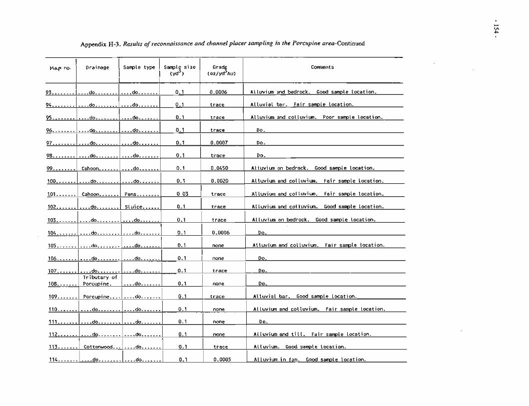
Appendix H-3. Results ofreconnaissance a d channel placer sampling in the Porcupine area-Continued
p . Drainage sample type 1 size 1 a 1 I I
I (Y ) I (OZ/Y Au)
Comnents
Alluviun and bedrock. Good sample location.
Alluvial bar. Fair sawle location.
Alluviun and colluviun. Poor sample location.
Do.
Do.
Do.
Alluviun on bedrock. Good sample location.
Alluviun and colluviun. Fair sample location.
Allwiun and colluviun. Fair sarrgle location.
Alluviun and colluviun. Good sample location.
Alluviun on bedrock. Good sample location.
Do.
105...
106 ...........
.... ....... 109 .......I Porcupine .... 1 do I 0.1 I trace I Alluvial bar. Good sample location.
0.1
0.1
0.1
0.1
0.1
0.1
0.1
0.1
do.......
.... do .......
I 93 ............ 94 ............
Do.
Do.
0.0006
trace
trace
trace
0.0007
trace
0.0450
0.0020
do ............ do........
Altuviun and collwiun. Fair sample location.
Do.
........ do ............ do ............
I I I I
107 ...........
108 .......
114 ....... 1 .... do ........ I....do....... 1 0.1 I 0.0005 1 Alluviun in fan. Good sample location.
95........
96 ............ 97 ............ 98 ............ 99... .....
100 ........... 101 ....... 102 ........... 103 ........... 104 ...........
do ............ Tributary of Porcupine.
Alluviun and colluviun. Fair sample location.
0 03
trace
none
....... do
.... ....... do
none 110 ........... Do.
Alluvium and till. Fair sample location.
Alluviun. G o d sanple location.
I
trace
none do .......
0 .1
0.1
I I I I I
none
none
trace
111.. .........
112 ........... 113. ......
.... do. ........... do ............ do......
do ............
Cahoon ........... do ............
Cahoon ....... do ........ do ............ do ............
0.1
do ............
do .......
do .......
...... do ....... do .......
do.......
do ....... Pans........
Sluice ...... do .......
....... do
I
....... do
do ............ do ............
Cottonwood
0.1
0.1
0.1
0.1 I none I
do.......
trace
trace
0.0006
0.1
do .......
do ....... ....... do.......
0.1
0.1
0.1
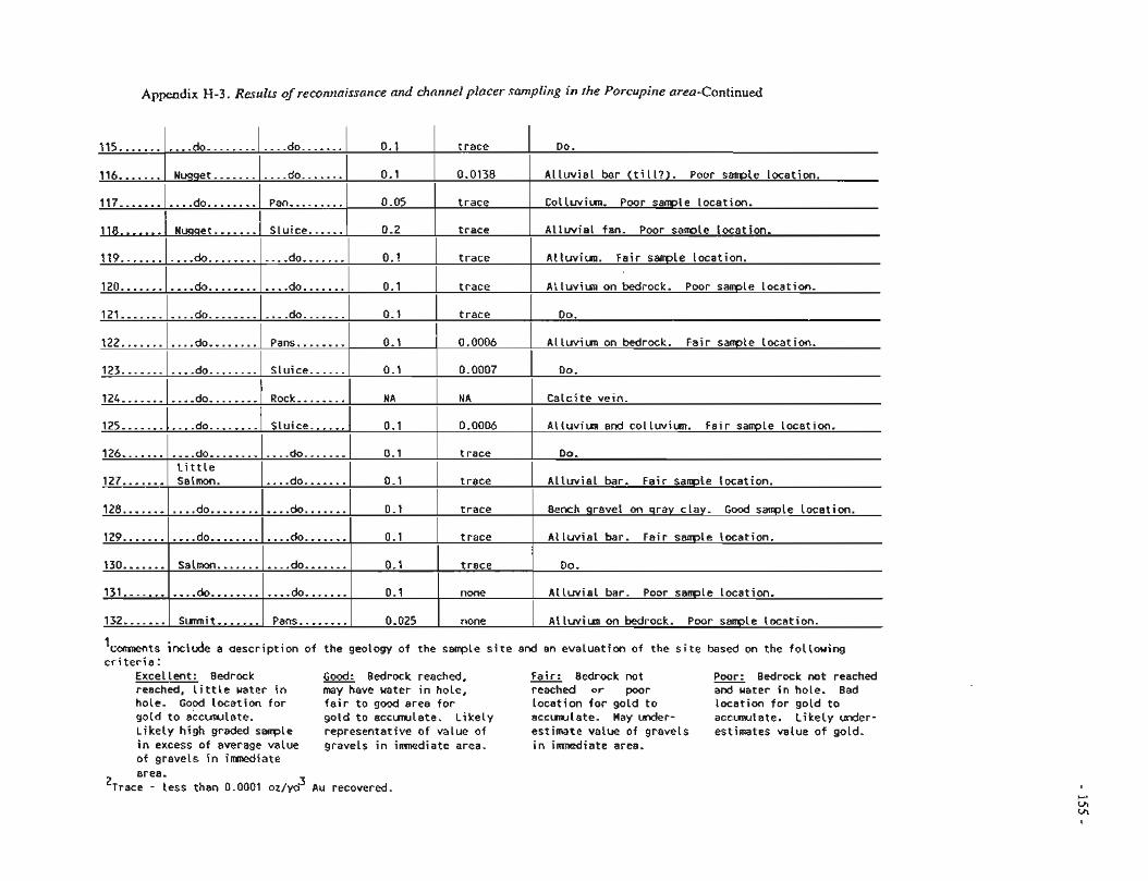
Appendix H-3. Results of reconnaissance and channel placer samplir~g in the Porcupirle area-@ontinu&
126 ....... l . . . . d 0 . . - . . - - . 1 ~ ~ ~ ~ d o ~ ~ . . ~ ~ ~ ] 0.1 1 t race I Do. I L i t t l e I I I I
127 ....... 1 Salmon. l....do.......l 0.1 1 t race I A l l u v i a l bar. Fa i r s a m l e locat ion. I I I I I
115 ........... 116 ....... 117 ...........
t race
0.0138
t race
t race
130 ....... 1 Sa lmn ....... I....do.......] 0.1 1 t race I Do. 1 I I I
Do.
A l l u v i a l bar ( t i l l ? ) . Poor sanple Location.
Colluviun. Poor sample locat ion.
A l l u v i a l fan. Poor s a m ~ l e locat ion.
128 ........... 129 ...........
131 ....... I....do........l....do.......l 0.1 none A l l u v i a l bar. Poor sample locat ion. I I I I I
ALlwiun. Fai r sanple Location.
A i l u v i m on bedrock. Poor sampie locat ion.
0.1
0.1
0.05
I 119 ....... l....d~..~.....
120.. ..... I ... .do.. .........
I ....... 118 1 Nugget. ......
do ............
Nuqqet ...........
do ........
i 3 2 ....... / Surmit ....... / Pans ........ 1 0.025 f none 1 A t l w i u n on M r o c k . Poor s a m l e Location.
I I ...... Slu ice / 0.2
....... do
....... do
Pan .........
do ............ do ............
'comments inc lude a aescr ip t ion o f the geology o f the sample s i t e and an evaluat ion of the s i t e based on the fo l low ing c r i t e r i a :
Excellent: Bedrock Good: Bedrock reached, Fair: Bedrock not - Poor: Bedrock no t reached reached, l i t t l e water i n may have water i n hole, reached o r poor and uater i n hole. Bad hole. Good loca t ion f o r f a i r t o good area f o r loca t ion f o r go ld t o locat ion f o r go ld t o go ld t o accunulate. go ld t o eccmwlete. L i k e l y accmwlate- Hay under- a c c m l a t e . L i k e l y u d e r - L i k e l y h igh graded sarrple representat ive o f value o f estimate value o f gravels estimates value o f gold. in excess o f average value gravels i n imnediate area. i n imnediate area. o f gravels i n imnediate area.
3 'irate - iess than 0.0001 oz/yo Au recovered.
121 ........... I do ............
.... do ....... I t race
do ....... do .......
I 0.1
I
.do.. ..... 0.1 I t race I
do .......
I
0.1 I t race I DO.
I I
0.1
0.1
122.......
123 ...........
124 ...........
I I I I I
t race
t race
A l luv iun on bedrock. Fa i r sample location.
Do.
Ca lc i te vein.
A l luv iun and c o l l w i u n . Fa i r sample Location.
I 0.1
Bench gravel on gray clay. Good sample locat ion.
A l l u v i a l bar. Fa i r sample locat ion.
.... do ........ do ........
0.0006
I 125 ....... l....do........
Pans........
S lu ice ......
...... Slu ice
I
0.1
I 0.0007
do ........ Rock ........ I
I A NA
0.1 1 0.0006 I
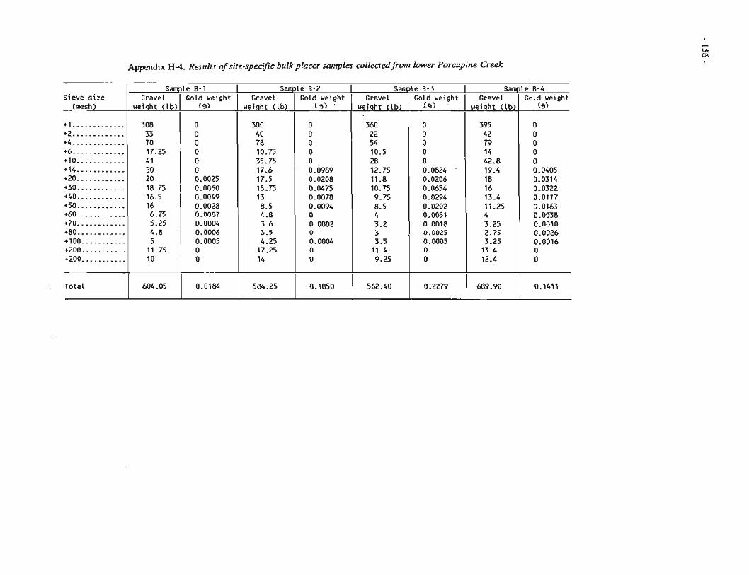
Appendix H 4 . Results of site-specific bulk-placer samples collectedfiom lower Porcupine Creek
Sieve s ize (mesh)
+1 ............. +2 ............. +4 ............. +6 ............. +lo ............ t14 ............ +20 ............ +30 ............ +40 ............ +50 ............ +60 ............ +70 ............ +80 ............ +I00 ........... +ZOO ........... .200 ...........
Total
Sample 0-1 Gravel
weight ( l b )
308 33 70 17.25 41 20 20 18.75 16.5 16 6.75 5.25
Sample Gravel
weight ( l b )
300 40 78 10.75 35.75 17.6 17.5 15.75 13 8.5 4.8 3.6 3.5 4.25 17.25 14
584.25
Gold weight (9)
0 0 0 0 0 0 0.0025
1 0.0060 0.0049 0.0028 0.0007 0.0004
8-2 Gold weight
c 3 ) '
0 0 0 0 0 0.0989 0.0208 0.0475 0.0078 0.0094 0 0.0002 0 0.0004 0 0
0.1850
Sample Gravel
ueiqht ( lb )
360 22 54 10.5 28 12.75 11.8 10.75 9.75 8.5 4 3.2 3 3.5
11 -4 9.25
562.40
4.8 1 0.0006 5 0.0005
1 1 -75 1 0
8-3 Gold weight L9)
0 0 0 0 0 0.0824 0.0206 0.0654 0.0294 0.0202 0.0051 0.0018 0.0025 0.0005 0 0
0.2279
Sample Gravel
weight ( l b )
395 42 79 14 42.8 19.4 18 16 13.4 11.25 4 3.25 2.75 3.25 13.4 12.4
689.90
10
604.05
8-4 Gold ueight
(9)
0 0 0 0 0 0.0405 0.0314 0.0322 0.0117 0.0163 0 -0038 0.0010 0.0026 0.0016 0 0
0.1411
0
0.0184