Embed Size (px)
Citation preview

PNT Interference Detection
U.S. Organizationand
Operating Concepts
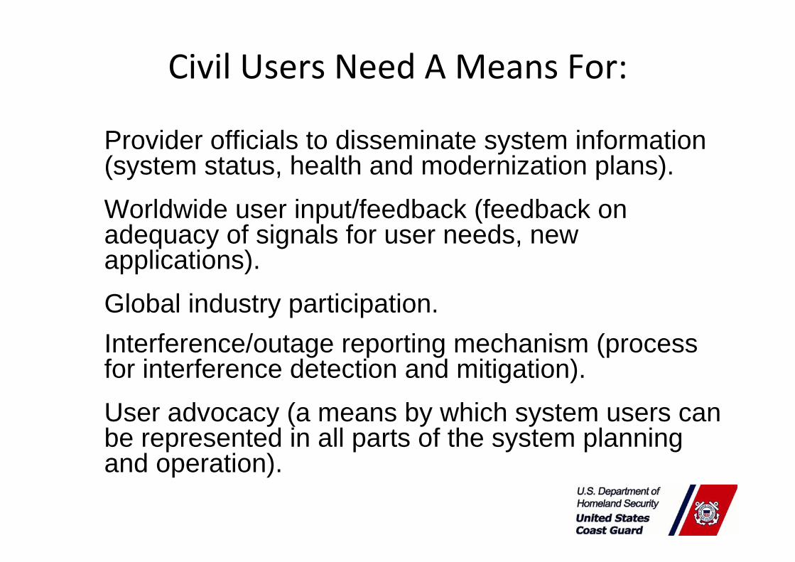
Civil Users Need A Means For:
Provider officials to disseminate system information (system status, health and modernization plans). Worldwide user input/feedback (feedback on adequacy of signals for user needs, new applications). Global industry participation.Interference/outage reporting mechanism (process for interference detection and mitigation). User advocacy (a means by which system users can be represented in all parts of the system planning and operation).

UNCLASSIFIED
Assignment of Civil Interface DutiesAssignment of Civil Interface Duties
•• 1986 1986 –– When GPS became a dualWhen GPS became a dual‐‐use (Military/Civil) system, use (Military/Civil) system, DOD formed an MOU with DOT for GPS Civil Interface. DOD formed an MOU with DOT for GPS Civil Interface.
•• DOT assigned operational interface to U.S. Coast Guard for DOT assigned operational interface to U.S. Coast Guard for dissemination of GPS operational informationdissemination of GPS operational information
•• Civil GPS Service Interface Committee (CGSIC) was formed. Civil GPS Service Interface Committee (CGSIC) was formed. This is now a DOT RITA responsibility as liaison between This is now a DOT RITA responsibility as liaison between worldworld’’s civil GPS users and U.S. GPS authorities s civil GPS users and U.S. GPS authorities

CGSIC CharterCivil GPS Service Interface Committee was chartered to be that forum.Recognized worldwide forum for effective interaction between all civil GPS users and the U.S. GPS authorities.Established and chartered to identify civil GPS user needs (e.g. navigation, timing, and positioning). Exchange information concerning GPS with the world-wide civil user community.Reports activities to the Office of the Assistant Secretary for Transportation.

5
U.S. Space‐Based PNT Organization Structure
WHITE HOUSEWHITE HOUSE
ADVISORY BOARD
Sponsor: NASA
ADVISORY BOARD
Sponsor: NASA
NATIONALEXECUTIVE COMMITTEEFOR SPACE-BASED PNT
Executive Steering GroupCo-Chairs: Defense, Transportation
NATIONALEXECUTIVE COMMITTEEFOR SPACE-BASED PNT
Executive Steering GroupCo-Chairs: Defense, Transportation
NATIONAL COORDINATION OFFICE
Host: Commerce
NATIONAL COORDINATION OFFICE
Host: Commerce
GPS International Working Group
Chair: State
GPS International Working Group
Chair: State
Engineering ForumCo-Chairs: Defense,
Transportation
Engineering ForumCo-Chairs: Defense,
Transportation
Ad HocWorking Groups
Ad HocWorking Groups
DefenseDefense
TransportationTransportation
StateState
InteriorInterior
AgricultureAgriculture
CommerceCommerce
Homeland SecurityHomeland Security
Joint Chiefs of StaffJoint Chiefs of Staff
NASANASA
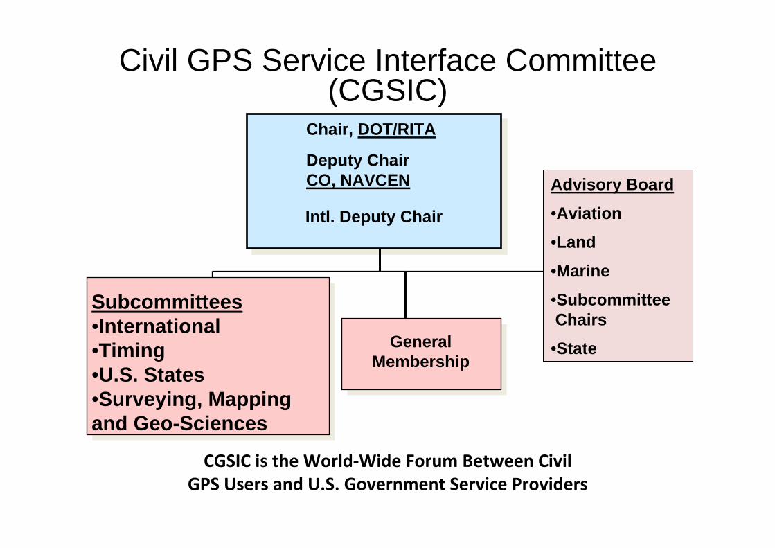
CGSIC is the World‐Wide Forum Between Civil GPS Users and U.S. Government Service Providers
Civil GPS Service Interface Committee (CGSIC)
Chair, DOT/RITA
Deputy Chair CO, NAVCEN Advisory Board
•Aviation
•Land
•Marine
•SubcommitteeChairs
•StateGeneralMembership
Subcommittees•International •Timing •U.S. States•Surveying, Mapping and Geo-Sciences
Intl. Deputy Chair

Civil LiaisonDOT Research and Innovative Technologies Agency assigned responsibility as PNT Lead for Civil GPS
Civilian liaison positions were established throughout the GPS program to safeguard civil interests:
•GPS Directorate Liaison•Civil liaison at U.S. Space Command•U.S. Coast Guard Navigation Center
Committee Co‐ChairExecutive SecretariatCoast Guard liaison at 2SOPS

NAVCEN Liaison to USAF GPSOC
• Attends Air Force Undergraduate Training for Space (5 wks)
• Provides the civil interface to GPS Operations Center.
• Works closely with DOD staff to monitor GPS satellite operations and maintenance to safeguard civil interests.
• Coordinate issue resolution between the GPS user and the DOD service providers.
• Supports civil users in resolving GPS outages by facilitating reports, coordinating findings, and disseminating results.
• Attends DOD Constellation Sustainment Assessment Team (CSAT) meetings to represent civil user input on GPS launch decisions.

OutreachAnnual meeting coAnnual meeting co‐‐located with IONlocated with ION
Subcommittee Meetings:Subcommittee Meetings:••International Information Subcommittee (UK Chair) International Information Subcommittee (UK Chair)
Annual European and Asia meetingsAnnual European and Asia meetings
••Timing (BIPM Chair)Timing (BIPM Chair)••Survey, Mapping and GeoSurvey, Mapping and Geo‐‐sciences (NGS Chair)sciences (NGS Chair)••States and Local Government (FHWA Chair)States and Local Government (FHWA Chair)
Two meetings annually in different cities around the countryTwo meetings annually in different cities around the country
Annual GPS Industry Partnership Day (LA AFB)Annual GPS Industry Partnership Day (LA AFB)
Conferences:Conferences:••Institute of Navigation (ION) GNSS ConferenceInstitute of Navigation (ION) GNSS Conference••ION Joint Navigation ConferenceION Joint Navigation Conference••European Navigation ConferenceEuropean Navigation Conference••Munich Satellite Navigation ConferenceMunich Satellite Navigation Conference

UNCLASSIFIED
Civil GPS RepresentationCivil GPS RepresentationNAVCEN provides for civil representation and advocates for civilNAVCEN provides for civil representation and advocates for civiluse of GPS at government meetings:use of GPS at government meetings:
•• GPS Constellation GPS Constellation SustainmentSustainment and Assessment Team (CSAT)and Assessment Team (CSAT)
•• GPS Interagency Forum for Operational Requirements (IFOR)GPS Interagency Forum for Operational Requirements (IFOR)
•• Civil GPS Program Management Review (PMR)Civil GPS Program Management Review (PMR)•• National PNT Engineering Forum (NPEF)National PNT Engineering Forum (NPEF)
•• DOS GPS International Working Group (GIWG)DOS GPS International Working Group (GIWG)
•• GPS Information Dissemination Coordination Team (IDCT) GPS Information Dissemination Coordination Team (IDCT)
•• United Nations International Committee on GNSS (UNUnited Nations International Committee on GNSS (UN‐‐ICG)ICG)
•• DOT and DHS POSDOT and DHS POS‐‐NavNav and Extended POSand Extended POS‐‐NavNav CommitteesCommittees
•• GPS Joint Service ReviewGPS Joint Service Review
•• Interface Control Working Group (ICWG)Interface Control Working Group (ICWG)

UNCLASSIFIED
Information FlowInformation Flow
•• Performance Standard and Interface Control Documents (ICD) Performance Standard and Interface Control Documents (ICD) provide technical information necessary to build equipment.provide technical information necessary to build equipment.
•• ISIS‐‐GPSGPS‐‐200 200 NavstarNavstar GPS Space Segment/Navigation User InterfacesGPS Space Segment/Navigation User Interfaces•• ISIS‐‐GPSGPS‐‐800 800 NavstarNavstar GPS Space Segment/User Segment L1C InterfaceGPS Space Segment/User Segment L1C Interface•• ISIS‐‐GPSGPS‐‐705 705 NavstarNavstar GPS Space Segment/User Segment L5 InterfaceGPS Space Segment/User Segment L5 Interface•• ICDICD‐‐GPSGPS‐‐060 GPS User Equipment (Phase III) Interface Control Document 060 GPS User Equipment (Phase III) Interface Control Document
for the Precise Time and Interval (PTTI)for the Precise Time and Interval (PTTI)
•• ICDICD‐‐GPSGPS‐‐240 details flow of operational information from 2SOPS to 240 details flow of operational information from 2SOPS to Triad.Triad.
•• Triad operations centers disseminate information through a varieTriad operations centers disseminate information through a variety ty of webof web‐‐sites and notification methodssites and notification methods

The GPS TriadThe GPS TriadJoint GPS User Support ServiceJoint GPS User Support Service
USAF GPSOC(military)
USCG NAVCEN(surface)
FAA NOCC(airspace)
FCC
JSCPIRT USSTRATCOM
NORAD/NORTHCOM
NTIA
Patriot Watch Customer Base/Users
13
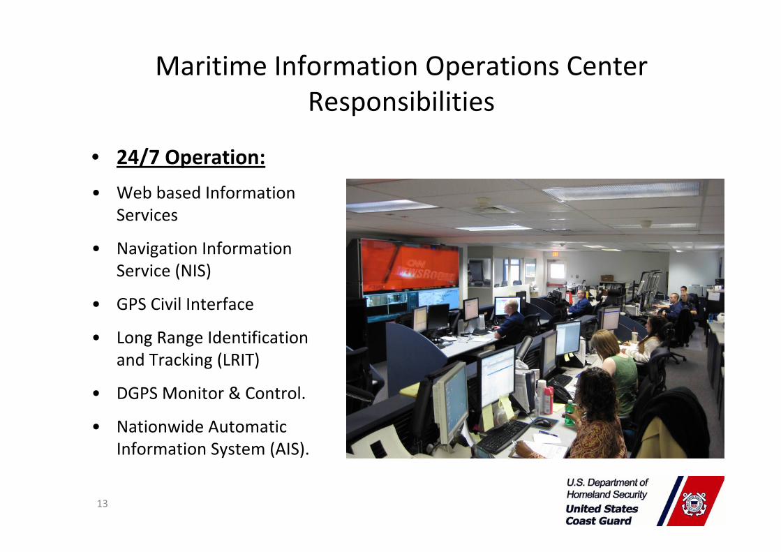
• 24/7 Operation:
• Web based Information Services
• Navigation Information Service (NIS)
• GPS Civil Interface
• Long Range Identification and Tracking (LRIT)
• DGPS Monitor & Control.
• Nationwide Automatic Information System (AIS).
Maritime Information Operations Center Responsibilities

UNCLASSIFIED
GPS CIVIL NOTIFICATIONGPS CIVIL NOTIFICATION
•• The TRIAD uses working relationships with partners to disseminatThe TRIAD uses working relationships with partners to disseminate e operational information operational information
•• NAVCEN has working relationships withNAVCEN has working relationships with•• Japan DGPS CenterJapan DGPS Center•• GLONASS Analysis CenterGLONASS Analysis Center•• Korea DGPS CenterKorea DGPS Center•• Canada: Canada: NavNav CanadaCanada•• Trinity House, UKTrinity House, UK•• Australia Air ServicesAustralia Air Services•• Et alEt al
•• Information is shared when it indicates effect to systems operatInformation is shared when it indicates effect to systems operated ed by other countries or areas of responsibility held by these by other countries or areas of responsibility held by these organizations.organizations.

UNCLASSIFIED
GPS Civil Performance GPS Civil Performance
•• The TRIAD uses DOD developed tools to predict GPS The TRIAD uses DOD developed tools to predict GPS performance impacts due to planned changes to the satellite performance impacts due to planned changes to the satellite constellation statusconstellation status
•• Enables prediction of Dilution of Precision (DOP); measure of Enables prediction of Dilution of Precision (DOP); measure of GPS user accuracy.GPS user accuracy.
•• High DOP triggers a coordinated regional user notificationHigh DOP triggers a coordinated regional user notification•• Notice to Mariners (NTM)Notice to Mariners (NTM)
•• Notice to Airman (NOTAM)Notice to Airman (NOTAM)
•• CGSIC List Server MembershipCGSIC List Server Membership

UNCLASSIFIED

UNCLASSIFIED
HD
OP
HDOP Hudson Bay 16Aug2010

www.navcen.uscg.gov

RAA2012-002: Boston Light Buoy, GPS Outage
GPS Performance Analysis
0000z - 2359z, 09 Jan 12

Analysis Overview / Assumptions
• Location of Incident:– Boston Light Buoy
• Coordinates:– Location N 42.2282° W 070.4171 °
• Date of Incident:– 2000z, 09 Jan 12
• Number of Incidents:– 1
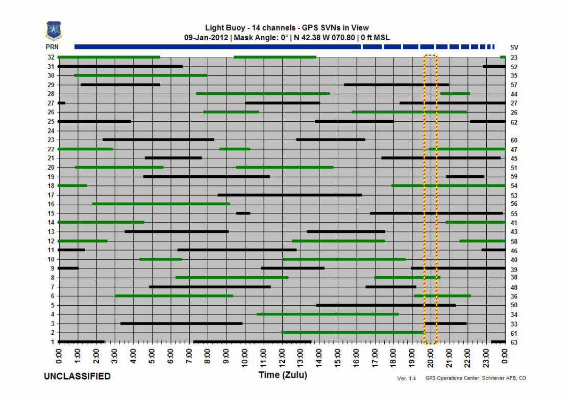
• Mask Angle:– Visibility Charts ‐ 0°– Contour and Spike Charts ‐ 5°
• Caveats:– None

Summary of Findings
• GPS Performance:– Best‐4 PDOP at 2000z, 09 Jan 12 in AOI was less than 3– Best‐4 Position Error at 2000z, 09 Jan 12 in AOI was less than 3 meters– All In View PDOP at 2000z, 09 Jan 12 in AOI was less than 2– All In View Position Error at 2000z, 09 Jan 12 in AOI was less than 2 meters
• Satellite Outages:– No outages
• Solar and Geophysical Weather:– Energetic Events: Nothing significant– Proton Events: Nothing significant– Space Environment Analysis: Nothing significant– X‐Ray Flux: Nothing significant
• EMI/RFI– No EMI/RFI events were observed at or near the locations in question.
• Other Analysis/Findings:– No other factors were found indicating a possible cause for loss or degradation of the GPS signal
over the requested area.

PDOP Max | Best 4 | Boston Light Buoy0000z-2359z, 09 Jan 2012

Position Error Max (m) | Best 4 | Boston Light Buoy0000z-2359z, 09 Jan 2012

PDOP/HDOP/Position Error Chart | Best-4 | Boston Light Buoy0000z-2359z, 09 Jan 2012

PDOP Max | All In View | Boston Light Buoy 0000z-2359z, 09 Jan 2012

Position Error Max (m) | All In View | Boston Light Buoy0000z-2359z, 09 Jan 2012

PDOP/HDOP/Position Error Chart | All In View | Boston Light Buoy0000z-2359z, 09 Jan 2012

Space Environment Analysis09 Jan 2012

Back up slides

• Protect the Nation’s 18 Critical Infrastructure & Key
Resource Sectors
• System‐of‐Systems, open architecture, multi‐
phased/multi‐layered approach
• Near real‐time situational awareness of PNT Interference
– Leverage existing mature capabilities & focus on the data, less
on system/device
– Common Data Structure for Information Sharing
– Persistent monitoring for situational awareness

Monitoring & Data Collection Processing Analysis &
Evaluation
FCC/FAA Receiver/Sensors
Crowd Sourcing
Applications
Fleet Management

Mitigation ‐‐ Resiliency
• Master Clock Distribution via Optical Networks
– Utilize existing fiber infrastructure
– Successful prototype
– Long‐haul test between pre‐determined sites to evaluate physical capabilities, baseline
– Distribution of Master Clock to specific demarcation

Department of Homeland Security
PNT Program Management [email protected]
202‐447‐3731 (O)
202‐731‐9628 (M)