Embed Size (px)
Citation preview


Policy Plan
Boyle Park Neighborhood Action Plan Area
Prepared by: Boyle Park Neighborhood Action Plan Steering Committee
City of Little Rock
Department of Planning and Development 723 W. Markham Street
Little Rock, AR 72201-6863
January, 2001

Boyle Park Neighborhood Action Plan
Area Neighborhood Associations:
Broadmoore College Terrace Point O’ Woods
(Although these Neighborhood Associations are representative of a majority of the Action Plan area not all residents of these Associations participated in the planning process. The Association Presidents were presented the Draft Document for Review and a request was made for a Champion of the Plan to proceed to the Planning Commission and the Board of Directors. One was not identified therefore, the plan has been published without acknowledgement from the Planning Commission and the Board of Directors. ) Steering Plan Committee Participants:
Sandy Edlemon Jim Fribourgh June Gillem Calvin Hanna Amanda Pannell Al Porter John T. Redd Marty Sherrill Rick Shock Maggie Thompson
City Staff: Quenton Burge, Planning and Development Chandra Foreman, Planning and Development Donna James, Planning and Development

TRAFFIC CONTROL Goals, Objectives and Action Statements (Summary) The area is surrounded on three sides by businesses, institutions, shopping centers and an interstate highway. The fourth side is covered by Boyle and Kanis Parks. University Park and the Haven Rest Cemetery are located within the Neighborhood Plan area. The Interstate (I-630) has one of the heaviest traffic loads in Arkansas while the Asher and University Avenues intersection has been cited as one of the city’s second heaviest traveled intersections. Area residents expressed concern over the amount of non-residential traffic accessing the neighborhood. A portion of the traffic from W. 12th Street, Asher and University Avenues now “cuts-through” the Boyle Park Neighborhood Plan area. S. Cleveland Street has become one of the main traffic arteries in the city. The former dirt roads, S. Cleveland Street and Boyle Park Road, now have traffic signals and humps to route and slow the heavy “cut-through” traffic in the area. In the north-south direction, Boyle Park Road via West Park Drive to W. 12th Street has been closed and W. 17th Street (Bittersweet Drive) was closed for a housing development. Then Boyle Park Road was realigned and extended to University Avenue at W. 19th Street and a traffic signal installed. Non-residential traffic now uses Berkshire, Broadmoor, S. Bryant, S. Cleveland, Glenmere and S. Hughes Streets as well as Boyle Park Road. The nearest north-south routes, other than S. University Avenue, are Fair Park Boulevard and John Barrow Road. The east-west non-residential traffic uses, for the most part, W. 32nd and Archwood Streets to W. 28th or W. 36th Streets and the alternative streets are W. 12th Street and Asher Avenue. Additional roads into the Boyle Park Neighborhood Plan area have been closed to accommodate non-residential enterprises in the last 15 years. The non-resident traffic moves rapidly over narrow roads and around parked cars which is dangerous to the driver and pedestrians alike. This traffic is gradually increasing and it includes cars, trucks, semi’s, CAT and school busses. As a result of the traffic changes the attractiveness of the Boyle Park Neighborhood Plan area is decreasing. Goal:
∗ Ensure safe and efficient movement of traffic in, around, and through the neighborhood. Objectives:
∗ Alter the traffic pattern to reduce or eliminate “cut-through” traffic in the Boyle Park Neighborhood Plan area.
Boyle Park Road: No Sidewalks Open Ditches
∗ Reduce the volume and speed of all traffic on area streets. Action Statements:
∗ Construct Boyle Park Road to Master Street Plan design standards (Careful consideration should be given to design as to not diminish safety for park users)
∗ Extend West Park Drive south to connect to Boyle Park Road to reduce the volume of cars accessing W. 12th Street via Broadmoor Drive and S. Cleveland Street
Boyle Park Area Neighborhood Action Plan – Policy Plan 1

Traffic Control Goals, Objectives and Action Statements (Page 2)
∗ Take necessary action to increase the visibility for motorists exiting from Monica Drive turning onto W. 32nd Street - (blind hill to the right)
∗ Eliminate “blind curve” on Boyle Park Road at Westpark Apartment Complex – (Remove trees on the southeast side of Boyle Park Road at West Park Apartments which block motorist view)
∗ Improve sight distance at Boyle Park Road and Broadmoor Drive
∗ Conduct a traffic study to determine the need for speed deterrent devices on: Belmont Drive between Broadmoor Drive and Glenmere Drive; W. 32nd Street from S. University Avenue to west side of the hill just past Monica Drive; Woodcliff Circle from Rosemont Drive (Southeast)
W. 32nd Street at Monica Driveto Rosemont Drive (Northwest); S. Bryant Street from Archwood Drive to Asher Avenue; W 32nd Street from S. University Avenue to S. Bryant Street
∗ Conduct a traffic study to examine possible solutions for reducing “cut-through” traffic accessing Archwood Drive via Boyle Park Road
∗ Install a traffic signal at S. Hughes Street and W. 12th Street ∗ Amend the Master Bike Plan for Boyle Park Road to a Class III facility in order to reduce dependence
on vehicles for accessing the park from within the neighborhood
Boyle Park Area Neighborhood Action Plan – Policy Plan 2
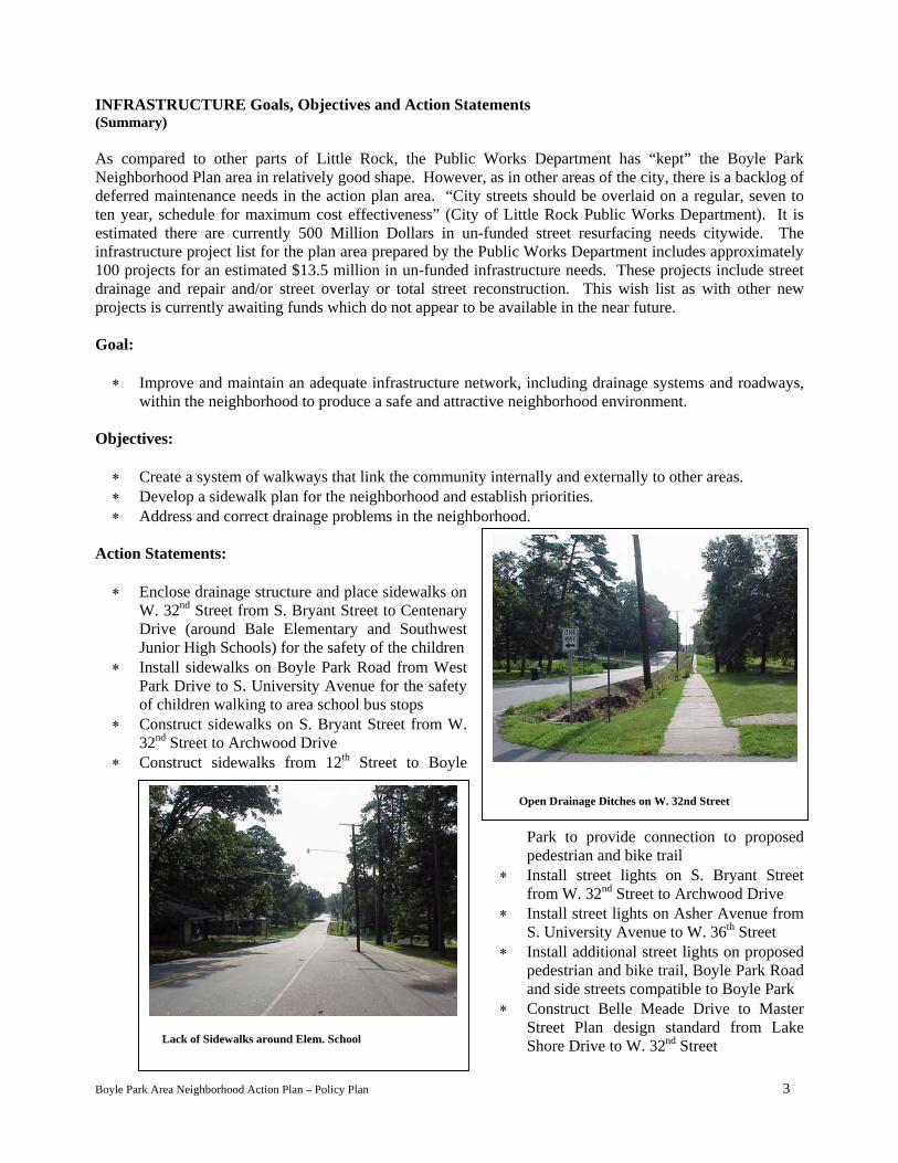
INFRASTRUCTURE Goals, Objectives and Action Statements (Summary) As compared to other parts of Little Rock, the Public Works Department has “kept” the Boyle Park Neighborhood Plan area in relatively good shape. However, as in other areas of the city, there is a backlog of deferred maintenance needs in the action plan area. “City streets should be overlaid on a regular, seven to ten year, schedule for maximum cost effectiveness” (City of Little Rock Public Works Department). It is estimated there are currently 500 Million Dollars in un-funded street resurfacing needs citywide. The infrastructure project list for the plan area prepared by the Public Works Department includes approximately 100 projects for an estimated $13.5 million in un-funded infrastructure needs. These projects include street drainage and repair and/or street overlay or total street reconstruction. This wish list as with other new projects is currently awaiting funds which do not appear to be available in the near future. Goal:
∗ Improve and maintain an adequate infrastructure network, including drainage systems and roadways, within the neighborhood to produce a safe and attractive neighborhood environment.
Objectives:
∗ Create a system of walkways that link the community internally and externally to other areas. ∗ Develop a sidewalk plan for the neighborhood and establish priorities. ∗ Address and correct drainage problems in the neighborhood.
Action Statements:
∗ Enclose drainage structure and place sidewalks on W. 32nd Street from S. Bryant Street to Centenary Drive (around Bale Elementary and Southwest Junior High Schools) for the safety of the children
∗ Install sidewalks on Boyle Park Road from West Park Drive to S. University Avenue for the safety of children walking to area school bus stops
∗ Construct sidewalks on S. Bryant Street from W. 32nd Street to Archwood Drive
∗ Construct sidewalks from 12th Street to Boyle
Park to provide connection to proposed pedestrian and bike trail
∗ Install street lights on S. Bryant Street from W. 32nd Street to Archwood Drive
∗ Install street lights on Asher Avenue from S. University Avenue to W. 36th Street
∗ Install additional street lights on proposed pedestrian and bike trail, Boyle Park Road and side streets compatible to Boyle Park
∗ Construct Belle Meade Drive to Master Street Plan design standard from Lake
nd
Boyle Park A
Lack of Sidewalks around Elem. School
rea Neighborhood Action Plan – Policy Plan
Open Drainage Ditches on W. 32nd Street
Shore Drive to W. 32 Street
3

INFRASTRUCTURE Goals, Objectives, Action Statements (Page2)
∗ Resurface Asher Avenue from S. University Avenue to W. 36th Street and install sidewalks on both sides of the roadway
∗ Control the mosquito population in the open ditches around Point O’ Wood Subdivision ∗ Reduce the flooding of Coleman Creek with restoration measures that utilizes natural functions of
stream dynamics ∗ Repair and resurface Town and Country Avenue ∗ Restoration of natural functions and stream dynamics to minimize flooding at Glenmere Drive and
Boyle Park Road drainage system which flows into the Rock Creek – (One small drain handles all the drainage from S. Cleveland Street across the Broadmoor Subdivision to Glenmere Drive. This overflow is eroding the banks of Rock Creek and Boyle Park Road.)
Boyle Park Area Neighborhood Action Plan – Policy Plan 4

HOUSING Goals, Objectives, Action Statements (Summary) The Broadmoor area of the Boyle Park Neighborhood Action Plan began developing as “America’s Finest Residential Development of Year Round Air-Conditioned Homes” in the early 1950’s. Hamilton Brack Addition, Interurban Heights Addition, College Terrace Addition, Point O’ Woods, University Park, University Park North and Broadmoor North Subdivision followed over the next 40 years. The area was predominately “built-out” by the early 1980’s. The area has or borders on large shopping areas located on three sides. There are about 30 eateries located within the plan area. Also within the area are six churches, two schools, four parks, a swimming pool, a neighborhood lake, a YWCA, a child care center and a half-way house for federal prison releases. Across University Avenue is the expanding University of Arkansas at Little Rock. The intersection of University Avenue and Asher Avenue has been noted as the second busiest intersection in the State. There were approximately 1500 residential lots final platted and currently approximately 1450 single-family residences are located in the area (according to the City Geographic Information System). The existing housing stock, although aging, has been well maintained. A neighborhood survey conducted in the area indicated what attracted persons to the neighborhood and what they liked most about the neighborhood were similar: affordability, location and proximity to work, schools, recreational activities and shopping. When asked if they could change one thing in their neighborhood the highest number of responses were more stringent and better enforcement of property maintenance standards, encourage more young families to move into the area and not allow parking on the street or on lawns. From the perspective of area residents the Boyle Park Neighborhood Action Plan area would like to continue its status of ‘a great neighborhood to live and raise a family’. Goals:
∗ To create a positive living environment for the residents and visitors to the Boyle Park Neighborhood
Action Plan area. ∗ Encourage growth, maintain and enhance the quality and affordability of existing housing. ∗ To stabilize and increase property values in the Boyle Park Neighborhood Action Plan area. ∗ Champion the neighborhood as an environment that supports independence and personal development
while recognizing and respecting the diversity of its residents. Objectives:
∗ Encourage existing renters to become home owners. ∗ Hold property owners accountable for the appearance and condition of their property as well as
accountable for sub-standard properties. ∗ Establish clear standards and expectations with absentee landlords who do not maintain their property. ∗ Review neighborhood zoning and future land use classifications for appropriateness. ∗ Review current ordinance which designates the authority of the Code Enforcement Division to enter
upon property and to determine health and safety issues.
Boyle Park Area Neighborhood Action Plan – Policy Plan 5

HOUSING Goals, Objectives, Action Statements (Page2) Action Statements:
∗ Improve the overall appearance of the neighborhood through enforcement of current and proposed regulations
∗ Require Housing and Neighborhood Programs to develop a handbook which identifies all existing Housing Code requirements (What constitutes a weed lot or an unsafe structure, What are the minimum housing code requirements, etc.) and distribute to all neighborhood associations and interested citizens
∗ Work with Housing and Neighborhood Programs and the City Attorney’s Office to review the validity of the existing Housing Code ordinance particularly the portion of the ordinance which gives authority to the Building Official to access properties for inspection
∗ Develop a list of available housing units and distribute it through various means, including a neighborhood newsletter, and to real estate agents through-out the city
∗ Market the neighborhood as an opportune area for first timout”
∗ Develop programs to educate potential home buyers of reshome (i.e. workshops on adequate insurance, simple home r
∗ Work with appropriate agencies to create incentives to enco∗ Work with Housing and Neighborhood Programs to i
rehabilitation assistance programs ∗ Work with the City of Little Rock on current and future pr
maintenance of their property ∗ Develop a database of available financing options for all inc∗ Require all rental and owner units (single-family and mul
manner (lawns and structures) ∗ Work with code enforcement officers to eliminate proper
codes ∗ Ensure out-of-town property owners maintain a local poi
codes ∗ Support legislation that will allow the City of Little Rock
town property owners (Long-Arm Statute) ∗ Work with the appropriate city department to remove non-o
front lawns ∗ Establish an ordinance that will increase the penalties for
successive violation ∗ Determine if existing future land use classifications ar
“neighborhood friendly businesses” ∗ Determine if existing zoning classifications comprom
neighborhood
Boyle Park Area Neighborhood Action Plan – Policy Plan
Residents Parking in the Street limiting Access of Emergency Vehicles
e homebuyers and young families “starting
ponsibilities of owning and maintaining a epairs) urage home ownership dentify residents who qualify for home
ograms designed to assist individuals with
ome groups ti-family) be maintained in a high-quality
ties in the area that do not meet existing
nt of contact to correct violations of city
to take enforcement action against out-of-
perating automobiles from city streets and
non-conformance incrementally for each
e best suited for future development of
ise the interest of stabilization of the
6

PARKS and RECREATION Goals, Objectives and Action Statements (Summary) There are four parks, a lake, adult leisure center, fitness center, and a YWCA in the area. The Broadmoor Association owns the lake, a park and a swimming pool. The fitness center is commercially owned while the YWCA and the adult center are quasi-publicly and publicly owned. The three city parks are Boyle Park, Kanis Park and University Park. Kanis Park is a sports park with softball, tennis and basketball areas. The basketball courts are located under the Interstate 630 Bridge. The park is well maintained and attended. University Park is the newest park with lighted tennis courts and a club house. It is well utilized especially at nights by players from all over the city. Boyle Park has a scenic area in a flood plain with four walking bridges. Photographers often use the area for “still-shots” and moving making. The southern part of the park has pavilions, and picnic tables that are no longer being used. There are two “kiddie play sets”, a couple portable restrooms and two basketball courts that are used by few. There are trails that a bicycle club uses occasionally. The northern half of the park is over-grown in weeds and brush except along Boyle Park Road. The park also has heavy vehicle traffic that travels Archwood Drive to W. 32nd Street and then to W. 36th Street to proceed north and out of the area. The park has been a staging area for burglars that prey on the neighborhood. Except for an occasional use the park is abandoned by the patrons and the Parks and Recreation Department. Kanis and University Parks are maintained with manicured lawns while Boyle Park is grown over in some areas. Goal:
∗ Create and maintain passive and active recreational activities for everyone in the community. Objective:
∗ Encourage usage of Boyle Park by area residents and the citizens of Little Rock. ∗ Encourage the City Parks Department and the Police Department to better maintain and patrol Boyle
Park. ∗ Support efforts for additional parks and recreational facilities in or around the plan area.
Action Statements:
∗ Continue to maintain Boyle Park, Kanis Park and University Park
∗ Work with the Parks and Recreation Department to eradicate the fire ant population in Boyle Park
∗ Complete planned recreational facilities within all the parks
∗ Encourage utilization of the parks within the area especially Boyle Park
∗ Construct facilities which would “draw” more activity to Boyle Park – i.e. construct soccer fields in the park to be used as practice fields for area schools, the university and area youth
∗ Increase the number of hours the Police Park Patrol spends in the area
∗ Reduce the volume of vehicular traffic using the park as∗ Maintain safe bicycle trails
Boyle Park Area Neighborhood Action Plan – Policy Plan
Adult Leisure Center
a “cut-through” street
7

ZONING AND LAND USE Goals, Objectives and Action Statements (Summary) Boyle Park Neighborhood has around 2838 (2729 occupied) housing units with 55 percent of these being owner occupied. It is possible that the neighborhood in a few years could have a higher percentage of rental housing units than owner occupied housing units should the addition of multi-family units become reality. Little Rock has 35 zoning designations that govern the use of land for commercial, industrial, office, multiple and single family housing. Any changes in these zones are acted upon by the Board of Directors. Our Neighborhood is “built-up” except for a few areas. These are: along Boyle Park Road north of Glenmere Drive to the east; Boyle Park Road to S. McKinley Street on the north; an area of undeveloped lots between W. 12th Street, S. University Avenue and S. Cleveland Street; along Leander Drive south of W. 12th Street (Kanis Road); along Rodney Parham Road at the junction with W. 12th Street. There is an area along Boyle Park Road (seven acres) under agreement with the Broadmoor Association, for single-family units only. West Park Meadows and a site on Leander Drive have proposals to add multi-family units to the area. To the east of S. Cleveland Street, a proposal has been made to replat six lots into three for future office development. A convenience store has been proposed to be built along Rodney Parham Road at W. 12th Street. Other small tracts and vacant structures allow for commercial and city buildings to potentially locate along the perimeter of the Neighborhood. While Little Rock expands in area the population remains nearly the same. The Boyle Park area has and will have increased population should the additional multi-family units be constructed. The Neighborhood could also experience even more roads being closed such as S. McKinley Street while the number of vehicles in and going through the Neighborhood grows rapidly. Boyle Park area residents were late to learn that the Federal Half-way House could be constructed on lands zoned O-3 – General Office. Since development of the ‘Half-Way’ house allowed uses under O-3 zoning have changed to require review of all new and existing half-way houses. Correctional facilities now require a conditional use in any zone. This assures public notification and Planning Commission review. A review of the Federal Correction ‘Half-Way House’ will be undertaken in 2001. Zoning has allowed builders to close off the grid of street that once existed in the area. With the increased population, traffic lights, etc. there will be an increased volume of traffic through the Neighborhood. Goal:
∗ Work toward establishing compatibility between land uses and zoning in the area, as well as compatibility of residential and non-residential uses. Try to maintain the Neighborhood as it is currently, even though zoning changes have already disrupted this goal.
Objective:
∗ Protect the residential integrity of the neighborhood by maintaining adequate separation or sufficient buffering between residential and non-residential uses.
Boyle Park Area Neighborhood Action Plan – Policy Plan 8

ZONING AND LAND USE Goals, Objectives and Action Statements ZONING AND LAND USE Goals, Objectives and Action Statements (Page 2) (Page 2) Action Statements: Action Statements:
∗ Set up a review committee to monitor rezoning request before they are presented to the Planning Commission and/or the Board of Directors
∗ Set up a review committee to monitor rezoning request before they are presented to the Planning Commission and/or the Board of Directors
∗ Ensure the Planning Department keeps the review committee informed of pending changes in the Neighborhood
∗ Ensure the Planning Department keeps the review committee informed of pending changes in the Neighborhood
∗ Encourage low density multi-family and/or single-family residential development to take place on currently vacant lands within the neighborhood
∗ Encourage low density multi-family and/or single-family residential development to take place on currently vacant lands within the neighborhood
∗ Encourage non-residential developments to be low intensity developments
∗ Encourage non-residential developments to be low intensity developments
∗ Office uses in the area should be limited to small scale medical services, legal services, financial services
∗ Office uses in the area should be limited to small scale medical services, legal services, financial services
∗ Discourage the conversion of existing single-family residential units to non-residential uses
∗ Discourage the conversion of existing single-family residential units to non-residential uses
∗ Discourage the location of traffic generating businesses within the residential areas of the neighborhood
∗ Discourage the location of traffic generating businesses within the residential areas of the neighborhood
∗ Support home based businesses which are limited to the existing guidelines of the current zoning ordinance
∗ Support home based businesses which are limited to the existing guidelines of the current zoning ordinance
∗ Keep McKinley street open ∗ Keep McKinley street open
Boyle Park Area Neighborhood Action Plan – Policy Plan
Scaled Office Use Construction
Single-Family Residents Converted to Non-Residential Uses
Low Density Residential Development
9

CRIME AND SAFETY Goals, Objectives and Action Statements Through the development process, residents expressed concern with loitering and criminal activity in and around Boyle Park. According to crime statistics criminal activity is for the most part located in the areas adjacent to Asher Avenue. The multiple routes to, from and within the neighborhood and the proximity to major arterials and expressways allow easy access and egress to perpetrators. The neighborhood has, thus far, rebuffed the crime from the surrounding neighborhoods. In the residents view there is minimal daily crime. Lawn items are targets for petty burglaries as is the case with all parts of the city. Broadmoor Association has a functioning crime watch program and break-ins have decreased. In general the neighborhood is a quiet safe place to live and work. Goal:
∗ Provide a safe and secure environment for area residents and visitors. Objective:
∗ Discourage crime throughout the neighborhood by a collaborative action. Action Statements:
∗ Reeducate residents and expand the crime watch program to the entire neighborhood ∗ Make Police Department aware of problems in the area and request an increase of patrol officers when
situations arise ∗ Educate residents of the importance of ‘knowing your
neighbor’ and reporting suspicious activity ∗ Educate residents on the importance of making their homes
safe and visible from the street (trim hedges around the structure, use reinforced dead bolts, use timers for light when residents are away from home)
∗ Continue monitoring of the activities of the “Half-Way House” to keep the residents informed
∗ Request the city enforce the noise ordinance concerning loud music from vehicles driving through the area Blocked View of Front Door by Hedges
∗ Inform area residents of Police Department phone numbers to call when requesting assistance
o Immediate Emergency Assistance – 911 o Non-Emergency Incidents – 371-4829 o Traffic Problems and Radar Enforcement Request – 918-3500 o Vacation Home Reports – 918-3500
Boyle Park Area Neighborhood Action Plan – Policy Plan 10

Existing Conditions
Boyle Park Neighborhood Action Plan Area
City of Little Rock Department of Planning and Development
April 2000
Boyle Park Area Neighborhood Action Plan – Existing Conditions 11

Introduction The Boyle Park Neighborhood Plan is designed to guide current and future development in the area in accordance with the needs and desires of the residents and business owners of the neighborhood. The study area is composed of block group 2 of census tract 21.01 and block groups 1, 3, and 4 of census tract 21.02. The neighborhood is in the Boyle Park Planning District but only consists of the northeastern third of the district. The topography of the neighborhood varies from floodplain along the Rock Creek, which runs through the western portion of the neighborhood, to gently sloping hills. The Boyle Park Neighborhood is located in central Little Rock in township 1N range 13W sections 1, 2, 12 and 13. More specifically, the physical boundaries for the neighborhood begin with Interstate 630 as the northern boundary while the eastern and southern boundaries are S. University Avenue and Asher Avenue respectively. The western boundary for the neighborhood is W. 36th Street and continues along the street to the western most boundary of Boyle Park. The western boundary continues along the western boundary of Boyle Park to W. 24th Street at which point it branches to the northwest, crosses Kanis Road and Riley Drive and meets Interstate 630 just before the Barrow Road access to the interstate. Residents of the Boyle Park Neighborhood were contacted by mail. Surveys were sent to addresses contained in the Geographic Information Systems (GIS) database at the City of Little Rock Planning and Development Division. Approximately 2,000 questionnaires (2148) were sent to residents, business owners and others with a vested interest in the neighborhood. The City attempted to survey every household in the neighborhood. Surveys returned (by the requested date of March 3, 2000) totaled 336 or 15.6% percent of households in the neighborhood. When including the surveys received after March 3, 2000 the total percentage of people’ responding to the survey is approximately 20%. (The responses received after March 3rd were not included in the analysis but the comments received from these surveys were provided to the committee for consideration in the development of the action plan.) Area History Development in the Boyle Park Neighborhood has a history that begins in the early part of the twentieth century and spans to the present. One of the first developments in the area was the donation of 243 acres in 1929 by Mr. and Mrs. John F. Boyle to the City of Little Rock for the creation of a municipal park. The corporate limits of Little Rock at the time were still several miles to the east and only pavilions and maintenance buildings were built in the park in 1936. It was not until the 1960’s that the park began to acquire more facilities. In the 1960’s dramatic change began in the area. The City had begun annexation of the area in 1954 and by 1964 a series of eight annexations had brought the entire study area within the corporate boundaries of the City. The area was primarily annexed by petition of real estate owners in the area. Historically, the area had been used for rural residential living and small area farming. Yet as early as 1953, subdivision development had occurred in the Broadmoor Addition along Hayes Street or what is today University Avenue. Population in the neighborhood totaled approximately 2,500 according to the 1960 U.S. Census. During the late 1950’s and throughout the 1960’s and 1970’s the area experienced tremendous residential and commercial development. Land use in the area was primarily dominated by single family residential use but commercial use began to arise along arterial streets and at intersections. By 1970 the area had more than doubled in population with approximately 5,500 residents. By the end of the 1970’s and early 80’s the population growth of the area began to slow significantly with only a fractional increase in population. As the graph that follows illustrates, the 1980 population of the neighborhood totaled 5,900. By 1990 the population had dropped by 20 percent to 4,800 residents.
Boyle Park Area Neighborhood Action Plan – Existing Conditions 12

B o y le P a rk N e ig h b o rh o o d P o p u la tio n 1 9 6 0 -1 9 9 0
2 5 0 05 5 0 0
5 9 0 04 8 0 0
0
2 0 0 0
4 0 0 0
6 0 0 0
8 0 0 0
1 9 6 0 1 9 7 0 1 9 8 0 1 9 9 0
Y e a r
The slowed increase and then decline of population in the neighborhood could be attributed to a combination of two factors. First, previous City research (Boyle Park District Plan, 1982) indicates that the area was largely built out by the early 1980’s. Land or lots left undeveloped were most likely so because of their position in the floodplain or location on steep slopes. As such, little room for development and growth was available. In addition to being built out, a comparison of 1960-1990 Census data reflects an aging population. The 1960 and 1970 Census of the neighborhood presents a population with a high percentage of those under the age of eighteen and persons eighteen to sixty-four with lower percentages of persons age sixty-five and older. Yet, the general trend in the neighborhood population in more recent years is a decrease in persons eighteen and under and an increase in persons eighteen to sixty-four and sixty-five and older. Considering this general trend, a decrease in population could be expected. Many of the residents are likely to be empty nesters or retired. The Boyle Park Neighborhood has been a part of the City of Little Rock for almost fifty years. In that time it has experienced widespread subdivision development and substantial population increases. Recently the neighborhood has experienced a population decrease and the withdrawal of some commercial vendors. The goal of the Boyle Park Neighborhood Action Plan is to compile a guide for future economic and social growth in the area. Annexation Activity and Subdivision Development As previously stated, the Boyle Park Neighborhood came to be a part of the City of Little Rock through a series of eight annexations in a ten-year period. (With the general election of 1959 a large portion of the area north of Asher Avenue and east of John Barrow Road/Reservoir Road became a part of the City of Little Rock.) Subdivision development in these areas spanned over approximately thirty years. The progression of residential development can be followed by referencing the final plat dates of the subdivisions. Final plat dates usually indicate when infrastructure and street systems are complete and residential lots are ready to be sold and developed. The tables listed below detail the annexation and subdivision history of the plan area. This information is pertinent to the neighborhood action plan in that it provides a general guide of how and when the area was developed. Subdivision development began in the Broadmoor Addition with the final platting of 584 residential lots in 1953. Followed by the College Terrace Addition, 96 residential lots (1955) and the Point O Woods Addition, 108 residential lots (1956). The University Park Addition and the Broadmoor North
Boyle Park Area Neighborhood Action Plan – Existing Conditions 13

Addition were both a part of the 1960’s Urban Renewal Effort. Each of these areas had residential units existing which were demolished and new subdivisions platted. The University Park North Addition began residential development in 1967 with the final platting of 196 lots. It was not until December, 1977 the Broadmoor North Subdivision was final platted and began development. Non-residential developments followed a similar pattern with the final platting of areas along S. University Avenue, W. 12th Street and Asher Avenue. Westpark Subdivision (1971) and Freeway Business Park (1994) were two of the later subdivision added to the area. Annexation Number Date Addition Name Ordinance Number Acreage
18 2-15-54 Broadmoor/ UALR Addition
9478 50.0*
20
4-11-55 College Terrace Addition
9801 52
30 9-24-56 Requa’s Addition; Town and Country Addition
10293 5.5
33 7-8-57 Block 3, Hamilton Brack Addition
10574 1.0
35 8-12-57 Point O’Woods Addition
10609 40
42 9-8-59 Maryton Park Addition 10977 19.60 43
9-22-59 General Election 10987 14208.0*
69 3-8-64 Kanis-Barrow Road Area
11520 396.00*
* Only a portion of the annexation is located in the Boyle Park Neighborhood Subdivisions/Additions Lots Final Plat Dates
Broadmoor Addition
Lots 1-584 August 21, 1953
College Terrace
Lots 1-96 February 25, 1955
Point O’ Woods Addition
Lots 1-108 July 1956
Interurban Heights Addition
Blocks 1-8, Lots 1-12 December 5, 1957
School Wood
Lots 1-29 Tract A-E August 1960
Kennil-Worth Addition
3 Lots January 11, 1962
Burk’s Addition
5 Tracts October 26, 1962
Hamilton Brack Addition
Blocks 1-11 Lots 1-12 July 12, 1963
Penergraft
Tract 1 January 15, 1965
A.G.A. Replat
Tract 1 August 17, 1966
University Park North
Lots 1-196 January 3, 1967
Westpark
Blocks A-R August 19, 1971
Rushing Tice Subdivision
Tracts 1-5 October 19, 1970
Leslye Replat
April 5, 1972
Broadmoor North
Lots 1-170 December 12, 1977
Boyle Park Area Neighborhood Action Plan – Existing Conditions 14

Future Land Use Plan The Future Land Use Plan is intended to serve as a general guide for zoning decisions. It is used to provide a reasonable prediction of the future arrangement of land uses, given the various factors impacting the use of land. The plan represents a reflection of a wide variety of considerations which influence the use of land. These include the existing land use pattern, current zoning, the existing street pattern, the Master Street Plan, environmental characteristics and community goals and objectives. There are 10 of the cities 22 future land use classifications located in the neighborhood. A large portion of
the area is classified as single-family. When
Ia(
C Zcei
B
combining all the residential future land use classifications 47.55% of the area is designated as residential. Parks and Open Space (Boyle Park and Kanis Park) and Public Institutional (Churches and University Park) when combined with residential (87.79%) leave very little for what the neighborhood might consider obtrusive uses.
Future Land Use Acreage
0
100
200
300
400
500
600
Residential Parks and OpenSpace
PublicInstitutional
Commercial Office Light Industrial0%5%10%15%20%25%30%35%40%45%50%
Acres Percent of Total Acreage
n addition to the preceding chart the following table indicates the 10 Future Land Use category designations long with the acres of each (according to the city’s GIS) and the percentage of the total acreage of the area. See Appendix II for definitions of Future Land Use Classifications.)
Classification Acres Percent of Total Acreage
Single-Family 495.35 42.11%Parks and Open Space 351.13 29.85%Public Institutional 122.23 10.39%Commercial 79.57 6.76%Multi-Family 55.28 4.70%Office 27.47 2.33%Light Industrial 22.32 1.90%Suburban Office 14.34 1.22%Mobile Home 7.89 .67%Low Density Residential .87 .07%
urrent Zoning
oning is a tool of the police power, which is the power of the government to intervene in the lives of private itizens for the protection of public health, safety, and welfare. Zoning is the basic means of land use control mployed by local governments in the United States today. Zoning divides the community into districts and mposes different land use controls on each district, specifying the allowed uses of land and buildings, the
oyle Park Area Neighborhood Action Plan – Existing Conditions 15

intensity or density of such uses, and the bulk of buildings on the land. Zoning has been around the City of Little Rock since the 1930’s. The basic ordinance in which most cities in the United States have based their zoning was from New York City which first adopted a comprehensive zoning code in 1916. The New York City model ultimately influenced local zoning controls throughout the county in the 1920’s. Although the conceptual and legal basis for zoning was laid out in the 1920’s the major impact of widespread local zoning was not really felt until the period of rapid building that followed World War II. Traditional use regulations have separated land uses into four basic categories: residential, commercial, industrial, and agriculture. The City of Little Rock has additional zoning categories including office and mining. The general classifications of zoning represented in the neighborhood plan area include Agriculture (4 acres), Commercial (115 acres), Industrial (95 acres), Office (36 acres) and Residential (1015 acres). (These acres have been approximated.) More specifically, those areas zoned for single-family account for 73.67% of the area (R-2 and R-3). (See chart below.) The I-2 (Light Industrial) zoning in an area east of S. Hughes Street, n(Cemetery Property) and south oDevelopment) exists on Vogler Strelocated at the southwestern intersectadjacent to Asher Avenue. Other cRoad, S. University Avenue near Wand adjacent to Asher Avenue. Theadjacent to W. 12th Street, two arDevelopment) located near the intersnursery located near Leander Drive.
Zoning Cl
AF C-3 C-4 I-2 O-1 O-2 O-3 PCD PDO PID POD PRD R-2 R-3 R-4 R-5 R-6
Boyle Park Area Neighborhood Action Plan – Exi
the area is located along S. University Avenue (Brandon House) and in orth of W. 12th Street to near the Rodney Parham Road intersection
f W. 12th Street to the Rock Creek. A PID (Planned Industrial et for the concrete plant. The C-4 (Commercial, Open Display) zoning is ion of Broadmoor Street and S. University Avenue and a second location ommercial zonings in the area are concentrated along Rodney Parham . 12th Street, S. University Avenue near the Asher Avenue intersection re are six areas which contain Office zoning. Two of these areas are e adjacent to Boyle Park Road and two are POD’s (Planned Office ection of S. Bryant and W. 32nd Streets. The AF (Agriculture) is a plant (See Appendix II for definitions of Zoning Classifications.)
assification Acreage Percent of Total
4.31 .34% 85.98 6.81% 5.55 .44%
90.98 7.20% 8.26 .65% 3.08 .24%
23.72 1.87% 21.45 1.70%
.15 .02% 3.05 .242%
0.6 .048% 13.42 1.06%
885.40 70.10% 45.08 3.57% 10.55 .84% 35.89 2.84% 25.48 2.02%
Area Zoning
Residential80.24%
Agriculture0.32%
Office 2.85%
Industrial7.51%
Commercial9.09%
sting Conditions 16

Historical (1990 – 1999) data indicates rezoning activity has been minimal in the area. November, 1990 a request was approved at 6501 W. 12th Street to rezone 7.69 acres of property from R-5 to O-1 to be used as a public uses. In April of 1992 a request was made to rezone 6207 Northmoor Drive from R-4 to O-3 (.25 acres) which was denied. Planned developments in the area include Freeway Business Park PCD (Planned Commercial Development) in March, 1994 for a total of 12.8 acres and in June, 1995 a PDO (Planned Development Office) was approved for 1.14 acres. Two other approved cases were Murphy-Holitic POD (Planned Office Development) on the northwest corner of W. 32nd and Bryant Streets and Lowe POD (May, 1995) located at 3210 S. Bryant Street. Recent subdivision activity includes three cases Coney replat located along Asher Avenue four lots and 5.2 acres, Freeway Business Park 9 lots and 18.17 acres and Harvest Foods (Asher Avenue Site) subdivision site plan review 1 lot of 6.84 acres. The Boyle Park District Plan was adopted April 20, 1982 by Ordinance No. 14228. Amendments to the Future Land Use Plan in the neighborhood plan area since the adoption has been minimal. An amendment to change SF to SO was approved in August, 1994 for an area on Northmoor Drive bounded by the residential structures on Garfield Drive/Charlotte Drive/Cleveland Street and the commercial on S. University Avenue. Existing Land Use The Department of Planning and Development collected land use data on a area specific basis. Data was recorded in the field based on actual observations using the “windshield” method. The area is developed with five primary uses: residential, public institutional, office, commercial and industrial. Residential developments generally fall into three categories. Single-family housing developments which have occurred during the past 25 years, apartment complexes or multi-family developments and the final is residential developments which are scattered rural or semi-rural developments. As indicated previously the plan area began developing in the mid-1950’s and by the late 1970’s was primarily “built-out”. The predominate land use in the area is single-family detached residential units although there are approximately 500 multi-family units in the area. Located in the southwestern portion of the plan area is a mobile home park with approximately 50 units. Public Institutional uses consist of public and quasi-public facilities that provide a variety of services to the community such as schools, libraries, churches, utility substations or park lands. Within the boundaries of the plan area there are three park facilities (University Park, Boyle Park and Kanis Park), two schools (Bale Elementary and Southwest Junior High) and several churches. Office, commercial and industrial uses are located along W. 12th Street, Rodney Parham Road, Asher Avenue and S. University Avenue. The following chart summarizes the current existing land uses for the area according to the cities GIS.
Boyle Park Area Neighborhood Action Plan – Existing Conditions 17

Structure Type # of Structures
% of Total
Single-Family 1459 64.10% Mobile Home 52 2.28% Multi-Family duplex 13 .57% Multi-Family (3-6 units) 57 2.50% Multi-Family (7-20 units) 9 .40% Storage – Residential 523 22.99% General Commercial 84 3.69% Auto Related Commercial 14 .62% Office 15 .66% Medical Office 3 .13% Schools – Elementary and Jr. High School 7 .31% Vocational School – Business School 2 .08% Public Institutional 13 .57% Public Institutional – Recreational Facilities 3 .13% Private Recreation 3 .13% Industrial Uses 7 .31% Industrial Uses – Storage 12 .53%
Shopping Centers/Office Buildings/Warehouse Buildings As residential development began moving west to the “suburbs”, retail development also moved to the west. In most cases residential suburbs generally provided some commercial development along major arterial
streets and this is the case with the development pattern of the plan area. Along with retail development, office development, churches and schools began “popping-up” in the area. Commercial rents in the area vary from $5.50 per square foot to $10.00 per square foot. This is comparable rents to other parts of the city but is less than areas west of I-430. The occupancy rate of 79% is somewhat less than the overall occupancy rate citywide of 85%. Office rents of $6 to $12 is also comparable to other parts of the
city once again less than the area west of I-430. The occupancy rate of 82% is just above the citywide average of 81%. Warehouse rents compare to other areas of the city but the occupancy rate (99%) is extremely higher than the city average of 78%.
0
200000
400000
Commercial Office Warehouse
Non-Residential Occupancy of the Plan Area
Total Leased
The following information is provided by the Arkansas Business Report, Office-Retail-Warehouse, Lease Guide (1999). The information reported does not represent a 100 percent survey of the properties in the area. In addition Arkansas Business makes no effort to independently verify the information of the survey. For more information contact Jeff Williams, Editor Arkansas Business at 501-372-1443.
Boyle Park Area Neighborhood Action Plan – Existing Conditions 18

Use Center Name Property Address Total Sq.
Ft. Available
Sq. Ft. Available
$ / Sq. Ft.
C 6801 W. 12th Street 15695 0 $8 C 1216 University Avenue C University Plaza 1400 University Avenue 17,650 0 $10 C Broadmoor Shopping Center 2908 University Avenue 77367 11667 $8.75 C UALR Shopping Center 3400 University Avenue 16000 4800 $8.50-$10 C Town & Country Shopping
Center 3500 University Avenue 69016 46123 $5.50-$7
C 6419 Asher Avenue 9600 0 $6 C Asher Avenue Shopping Center 6420 Asher Avenue 132000 $9 C 6100 W. 12th Street O 6701 & 6705 W. 12th Street 56700 3640 $8.50 O 7107 W. 12th Street 10000 0 $12 O 1200 West Park 10000 3500 $10-$12 O West Park Executive Building 7011 W. 12th Street O 1300 West Park 12900 1500 $8 O 1400 West Park 10000 0 $7 W 6805 W. 12th Street 30000 0 $5.50 W 6807 W. 12th Street 20700 0 $5.50 W 1220 West Park 4500 1500 $8 W All Electric Supply 1301 West Park W All Electric Supply 1419 West Park 8000 W 1601 West Park 48290 0 $5 W 1500 West Park 38000 0 NA W 1501 West Park 113000 0 Varies C – Commercial; O – Office; W – Warehouse New Construction and Reinvestment in the Area New construction in the area has been limited over the past 10 years. There has been only one single-family unit permitted (1997) in the area. New non-residential activity has been active with at least one project permitted each year with the exception of 1997. As indicated previously the area began developing in the late 1960’s and continued into the early 1980’s. The area is predominately “built-out”, leaving little new construction potential. An area south of W. 12th Street and west of S. University Avenue has available vacant lands zoned for office development. The second area with a “large tract” of available land for development is in the western portion of the plan area near Leander Drive. A portion of this area was previously zoned for a PRD (Planned Residential Development) the remainder is zoned R-2 single-family district.
Boyle Park Area Neighborhood Action Plan – Existing Conditions 19

Building Permit Data Date Landuse Type Address Sq. Footage Construction
Cost Feb-90 Express Oil Change 6011 W. 12th Street $35,000 Sep-91 Adult Center 6401 W. 12th Street $650,000 Mar-92 Town & Country 3500 S. University Avenue $86,000 Apr-93 Health of 1209 Vogler Street $50,000 Jul-94 University Wholesale Florist 1501 Garfield Drive $430,000 Nov-94 Safelite Auto Glass 1306 S. University Avenue $350,000 Jul-95 Freeway Storage 18 Freeway Drive $750,000 Oct-95 Ray Lusk Plumbing Co. 921 Rushing Circle $9,000 Apr-96 Freeway Storage 18 Freeway Drive $412,000 Sep-97 Single Family House 11 Roane Circle $160,000 Sep-98 Office Building 1524 S. Garfield Drive 9,000 $270,000 Jul-99 Fuel Islands – Harvest Foods 6910 Asher Avenue $220,000 Nov-99 Wal-Greens 3720 S. University Avenue 15,070 $1,289,827 Nov-99 Pizza Hut – Rebuild 2912 S. University Avenue 3,520 $400,000 The area experienced two demolitions. One single-family unit at 3124 Ware Street in March of 1992 and one commercial structure at 2912 S. University Avenue (Pizza Hut) in August, 1999. A new Pizza Hut facility is currently under construction at the previous location (and has since opened). Residential renovation and addition activity for the area includes single-family and multi-family permits issued. Permit activity for the years of 1990 – 1999 has been reviewed. When comparing average renovation construction dollars only single-family units were examined. The area contains several larger apartment complexes which did permit renovation activity but addition activity was only reported for single-family units in the area. Of the renovation construction dollars permitted in 1991, $253,440 was for multi-family renovations. The total number of units was not reported. Of this $195,440 was expended at the Westpark Drive apartment complex as a result of fire damage. The Town and County Apartments permitted renovation activity in 1991 ($58,000), 1993 ($65,000) and in 1998 ($42,000) for repair of fire damaged units.
Year Renovation Construction Dollars Permitted
Average Renovation Single-Family
Addition Construction Dollars Permitted
Average Addition Single-Family
1990 $27,651 $13,825 $8,000 $1,3351991 $290,840 $18,700 $20,000 $20,0001992 $9,840 $3,280 $67,620 $11,2701993 $111,848 $6,695 $0 $01994 $87,000 $21,750 $14,800 $7,4001995 $50,330 $8,715 $4,100 $4,1001996 $68,397 $11,400 $20,000 $10,0001997 $55,065 $11,766 $31,000 $1,0351998 $134,226 $17,745 $44,200 $22,1001999 $89,500 $7,460 $150,003 $30,000
Boyle Park Area Neighborhood Action Plan – Existing Conditions 20

Reinvestment in the area can be
neexin Foavduex CA ThroStMdoUnUndoScShdo M TharThde A a sa mbofroW A prsp
Bo
illustrated by the amount of renovation and addition funds expended. Renovation activity usually represents where housing stock “lags behind”. In a majority of the cases the funds expended for renovations were to “bring the house up to code” or “fire damage”. Funds expended for an addition in living space to the structure usually indicates a strong commitment to the
ighborhood. There is no true pattern to examine the “commitment to the neighborhood” with the penditure of addition funds increasing in 1991 and decreasing in 1992 etc. with the exception of funds creasing in 1998 and in 1999.
Reinvestment in the Neighborhood
$0
$20,000
$40,000
1990 1991 1992 1993 1994 1995 1996 1997 1998 1999
Average Renovation Single-Family Average Addition Single-Family
r comparison of renovation and addition activity citywide activity for 1999 was used. Citywide the erage value of renovation activity for 1999 was $17,107 and the average addition funds expended citywide ring 1999 was $43,988. The neighborhood is comparatively below the city averages on both funds pended for renovation activity and funds expended for addition activity.
TA Bus Service
ree routes service portions of the area. The Baptist Medical Center, University Avenue and Rosedale bus utes. The Baptist medical center route starts downtown travels along W. Capitol Avenue to S. Battery reet, south along S. Battery Street to W. 12th Street traveling west along W. 12th Street to the Baptist edical Center “circling around” the facility and back to W. 12th Street to travel the same route east to wntown. University Avenue route travels W. 28th Street through the University of Arkansas Campus to S. iversity Avenue, west along Asher Avenue to S. Bryant Street, north to W. 32nd Street and east to S. iversity Avenue then north on S. University Avenue to W. 28th Street. The third route, Rosedale, starts wntown and travels along S. Broadway Street to W. 20th Street, traveling S. Wolfe Street, W. 21st Street, S. hiller Street to W. Roosevelt Road/Asher Avenue/Colonel Glenn Road. Then traveling north on ackleford Road to W. 36th Street east to Katherine/Potter Streets south to Asher Avenue and back to wntown.
aster Street Plan Street Classifications
ere are four Master Street Plan classification of streets other than residential or local streets within the plan ea. These are collector streets, minor arterial streets, principal arterial streets and a freeway/expressway. e following briefly describes these classifications and their functions along with the streets which are signated to each classification.
collector street is the traffic connection from residential streets to arterial streets or to activity centers, with econdary function of providing access to adjoining property. Street design speed is generally 30 mph with inimum pavement width of (back of curb to back of curb) 31’ or 36’. Sidewalks are to be constructed on
th sides and 5’ wide in commercial areas or one sidewalk 4’ wide in residential area (a minimum of 5’ m back of curb). The area contains six collector streets – Hughes Street, Bryant Street, Cleveland Street, . 32nd Street, Boyle Park Road and Leander Street.
minor arterial street provides the connections to and through an urban area. Their primary function is to ovide short distance travel within the urbanized area. Roadways are usually four travel lanes and design eed is 40 mph. Sidewalks are required on both sides of the roadway five feet wide and located at the
yle Park Area Neighborhood Action Plan – Existing Conditions 21
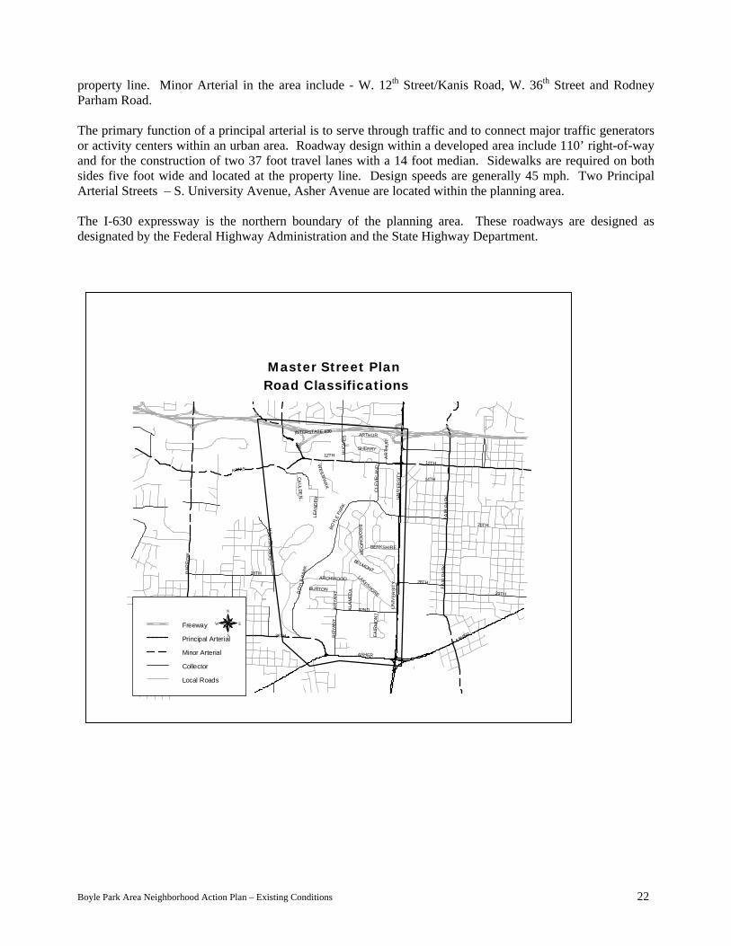
property line. Minor Arterial in the area include - W. 12th Street/Kanis Road, W. 36th Street and Rodney Parham Road. The primary function of a principal arterial is to serve through traffic and to connect major traffic generators or activity centers within an urban area. Roadway design within a developed area include 110’ right-of-way and for the construction of two 37 foot travel lanes with a 14 foot median. Sidewalks are required on both sides five foot wide and located at the property line. Design speeds are generally 45 mph. Two Principal Arterial Streets – S. University Avenue, Asher Avenue are located within the planning area. The I-630 expressway is the northern boundary of the planning area. These roadways are designed as designated by the Federal Highway Administration and the State Highway Department.
Bo
INTERSTATE 630
UN
IVER
SITY
CLE
VELA
ND
BOYL
E PA
RK
LAKESHOREBO
YLE
PAR
K
32ND
BR
YAN
T
BERKSHIRE
KANIS
WESTPAR
K
ARCHWOOD
BELMONT
36TH
ASHER
FAIR
MO
NT
BR
YAN
T
ALA
MED
ABURTON
BR
OAD
MO
OR
CAUL DE
N
LEA
NDE R
AR
T HU
R
SHERRY
ARTHUR
HU
GH
ES
28TH
FAIR
PA
RKFA
I R P
AR K
12TH
ASHER
29TH
20TH
14TH
28TH
DO
RC
HES
TER
WAL
KER
BAR
RO
W
UN
IVER
SITY
12TH
Master Street Plan Road Classifications
Freeway
Principal Arterial
Minor Arterial
Collector
Local Roads
N
EW
S
le Park Area Neighborhood Action Plan – Existing Conditions 22 y

Bike Paths, Bike Routes, Bikeways There are two Class I and two Class III bicycle facilities located within the neighborhood. A Class I bikeway is the total separation between automobile traffic and bicyclist. In some cases these facilities are constructed when connections are needed and no roadway exists. This is the case within the action plan area. The Rock Creek and the I-630 bikeways are each constructed adjacent to “creek beds”. The Rock Creek bikeway connects the I-630 Trail to the Mabelvale Pike Trail. The I-630 Trail connects Shackleford Road to Fair Park. Class III bikeways have no special signage and use existing vehicular area with no physical separation between automobile traffic and bicyclist. The Boyle Park bikeway and the 12th Street bikeway each exist in the plan area. The Boyle Park bikeway connects the Boyle Park trail to the UALR Trail. The 12th Street bikeway connects the Rock Creek Trail to Pine and Cedar Streets.
INTERSTATE 630
UN
IVER
SITY
CLE
VELA
ND
BOYL
E PA
RK
LAKESHOREBO
YLE
PAR
K
32ND
BR
YAN
T
BERKSHIRE
KANIS
WESTPAR
K
ARCHWOOD
BELMONT
36TH
ASHER
FAIR
MO
NT
BR
YAN
T
ALA
MED
ABURTON
BR
OAD
MO
OR
CAUL DE
N
LEA
NDE R
AR
T HU
R
SHERRY
ARTHUR
HU
GH
ES
28TH
FAIR
PA
RKFA
I R P
AR K
12TH
ASHER
29TH
20TH
14TH
28TH
DO
RC
HES
TER
WAL
KER
BAR
RO
W
UN
IVER
SITY
12TH
Designated Bike Routes
Bike RouteN
EW
S
Boyle Park Area Neighborhood Action Plan – Existing Conditions 23

Master Parks Plan Boyle Park (W. 36th Street and Boyle Park Road) occupies 243 acres of densely-wooded, gently-rolling land situated along the Rock Creek. In 1929, Mr. And Mrs. John F. Boyle donated this land to the City of Little Rock for the creation of a municipal park. The National Park Service in cooperation with the Arkansas State Parks Commission prepared the original master plan in 1936. Development of the park was accomplished as a project of the CCC and WPA programs. Several of the park’s structures were cited as model examples in the 1936 issue of “Park Structures and Facilities”, a manual published by the U.S. Department of the Interior. A special feature of the park is a 20-station fitness course constructed in 1981. Other features within the facility include playgrounds, bike path/jogging trail, fitness course, basketball courts, picnic tables, restrooms, 7567 square feet (3 buildings) in pavilions and 8176 square feet in maintenance buildings. Kanis Park (Rodney Parham Road/Mississippi Street and I-630) occupies 46 acres of level to gently-sloping land also along the Rock Creek. This tract of land was acquired from the E.D. Kanis family in 1968. The park was developed extensively in 1969 and in 1979 a link in the city bike path system was extend through the park. The facility contains a softball diamond, playground equipment, bike path/jogging trail, basketball court, tennis courts, picnic tables, restrooms and a 1200 square foot pavilion. University Park (W. 12th Street and S. Cleveland Street) occupies 24 acres of level to gently-sloping land. The site for University Park was acquired by the City of Little Rock from the Little Rock Housing Authority. The park was developed in 1979 and is a part of a joint-planning complex known as the “University Park -–Recreation and Education Facilities Complex”. The member agencies of this planning consortium are: the City of Little Rock, the Elizabeth Mitchell Children’s Home, the Little Rock School District, the Young Women’s Christian Association, and the Little Rock Boy’s Club. These agencies formed a review board which hired a consultant to coordinate plans for the overall development of the multi-agency complex. Rebsamen Tennis Center, which includes 13 tennis courts and special facilities for professional exhibition matches, is the major feature of University Park. In addition the city constructed the University Park Adult Leisure Center in 1991. This facility hosts events for senior citizens, and services the needs for meeting space for city and non-city events.
INTERSTATE 630
UN
IVER
SITY
CLE
VELA
ND
BOYL
E PA
RK
LAKESHOREBO
YLE
PAR
K
32ND
BR
YAN
T
BERKSHIRE
KANIS
WESTPAR
K
ARCHWOOD
BELMONT
36TH
ASHER
FAIR
MO
NT
BR
YAN
T
ALA
MED
ABURTON
BR
OAD
MO
OR
CAUL DE
N
LEA
NDE R
AR
T HU
R
SHERRY
ARTHUR
HU
GH
ES
28TH
FAIR
PA
RKFA
I R P
AR K
12TH
ASHER
29TH
20TH
14TH
28TH
DO
RC
HES
TER
WAL
KER
BAR
RO
W
UN
IVER
SITY
12TH
Parks System Master Plan
PK/OS PARK/OPEN SPACE
N
EW
S
Boyle Park Area Neighborhood Action Plan – Existing Conditions 24

Broadmoor Property Owners Association also maintains a private park facility to service the needs of area residents. The park facility includes a pavilion, playgrounds, picnic tables, swimming pool and a lake. The Park Systems Master Plan includes a network of trails through-out the city. One such trail is located along the Rock Creek extending north and south of the neighborhood plan area. Currently a small portion of the property adjacent to the Rock Creek (referring to proposed trails within the neighborhood plan area) is owned by the city. Area Schools There are two schools located within the plan area, an elementary school and a junior high school (both located on S. Bryant Street near W. 32nd Street). By law, an elementary school must provide the basic needs of education for children, which makes it an ideal foundation in a vibrant neighborhood. In neighborhoods, schools serve as organizational components by providing not only the educational needs, the school facility also serves as an integral part of the community’s cohesion. By permitting classrooms, cafeterias, and other facilities to be used after-hours, residents within a community can gather for events such as neighborhood alert meetings or neighborhood organization meetings. Also, outdoor facilities and indoor gyms provide after-hour recreation and non-structured open space. In an attempt to ensure educational opportunities and equality for all children, the Little Rock School District is subdivided into school attendance zones. In general, children who are enrolled in the public school system are assigned to attend school based upon their address of residence. For the 1999-2000 school year, the Little Rock School District redrew the attendance zones to accommodate the “middle” school concept which shifts six graders from elementary schools to the junior high schools and ninth graders from junior high schools to high schools. The “middle” school or junior high school now consists of sixth, seventh and eighth graders. Elementary school-aged children in the Boyle Park plan area who are enrolled in the public school system attend Bale Elementary School. Likewise, the junior high school-aged children attend Southwest Junior High School. High school aged students attend Parkview Arts/Science Magnet School located just outside the plan area. In the past, the boundaries of the attendance zones changed due to fluctuations in the numbers and addresses of children enrolled in the public school system. In general, these boundaries, were not drawn along neighborhood lines, in order to promoted integration between neighborhoods. A large percentage of the student population traveled by bus or private vehicle to their assigned school. The neighborhood school concept is intended to allow children to remain in their neighborhood for educational needs. Crime Data The data entered in this section is separated into eight different categories for the purpose of clarification: assault, burglary, criminal mischief, disturbance, robbery, runaway/missing, sexual crimes, theft, and other. In order to understand these categories, it is best to detail what criminal offenses were included in each category. From crime reports, all offenses listed as “Sexual” crimes are a compilation of offenses listed as rape, fondling and sexual misconduct. “Theft” crimes include shoplifting, larceny, pocket picking, till tapping, lost/stolen property, lost/stolen ID etc. “Robbery,” “Burglary,” “Assault,” criminal “Mischief,” “Runaway/Missing,” and “Disturbance” were taken from data entries of the same categorization. Other includes “Arson,” “Drugs and Alcohol Related” and “Suicide”. According to information provided by the Little Rock Police Department, crime in the area tends to be concentrated in certain areas. Most predominantly, the major center of crime is located along Asher Avenue and S. University Avenue around area merchants. Most of the sexual misconduct and some of the criminal
Boyle Park Area Neighborhood Action Plan – Existing Conditions 25
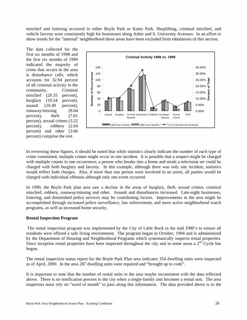
mischief and loitering occurred in either Boyle Park or Kanis Park. Shoplifting, criminal mischief, and vehicle larceny were consistently high for businesses along Asher and S. University Avenues. In an effort to show trends for the "internal" neighborhood these areas have been excluded from tabulations of this section. The data collected for the first six months of 1998 and the first six months of 1999 indicated the majority of crime that occurs in the area is disturbance calls, which accounts for 32.94 percent of all criminal activity in the community. Criminal mischief (20.35 percent), burglary (10.54 percent), assault (10.40 percent), runaway/missing (8.64 percent), theft (7.61 percent), sexual crimes (3.22 percent), robbery (2.64 percent) and other (3.66 percent) comprise the rest.
Criminal Activity 1998 vs. 1999
0
20
40
60
80
100
120
140
Assault Burglary CriminalMischief
Disturbance Robbery Runaway/ Missing
SexualCrimes
Theft0.00%
5.00%
10.00%
15.00%
20.00%
25.00%
30.00%
35.00%
1999 First 6 Months 1998 First 6 Months % of Total 98 & 99 Combined
In reviewing these figures, it should be noted that while statistics clearly indicate the number of each type of crime committed, multiple crimes might occur in one incident. It is possible that a suspect might be charged with multiple counts in one occurrence; a person who breaks into a home and steals a television set could be charged with both burglary and larceny. In this example, although there was only one incident, statistics would reflect both charges. Also, if more than one person were involved in an arrest, all parties would be charged with individual offenses although only one event occurred. In 1999, the Boyle Park plan area saw a decline in the areas of burglary, theft, sexual crimes, criminal mischief, robbery, runaway/missing and other. Assault and disturbances increased. Late-night businesses, loitering, and diminished police services may be contributing factors. Improvements in the area might be accomplished through increased police surveillance, law enforcement, and more active neighborhood watch programs, as well as increased home security. Rental Inspection Program The rental inspection program was implemented by the City of Little Rock in the mid 1990’s to ensure all residents were offered a safe living environment. The program began in October, 1994 and is administered by the Department of Housing and Neighborhood Programs which systematically inspects rental properties. Since inception rental properties have been inspected throughout the city and in some areas a 2nd Cycle has begun. The rental inspection status report for the Boyle Park Plan area indicates 354 dwelling units were inspected as of April, 2000. In the area 287 dwelling units were repaired and “brought up to code”. It is important to note that the number of rental units in the area maybe inconsistent with the data reflected above. There is no notification process to the city when a single-family unit becomes a rental unit. The area inspectors must rely on “word of mouth” to pass along this information. The data provided above is to the
Boyle Park Area Neighborhood Action Plan – Existing Conditions 26

best of the Department of Housing and Neighborhood Programs Code Enforcement Officer which services the areas knowledge of rental units available. Infrastructure Projects As in other parts of the city, there is a backlog of deferred maintenance needs on the streets in the Boyle Park plan area. According to Public Works Department, city streets should be overlaid on a regular seven to ten-year schedule for maximum cost effectiveness. The Infrastructure Project List, created by the Department of Public Works, reflects a ten-year overlay schedule for area streets. Costs vary by type of street. The list assumes that “substandard” streets are brought up to standard during the overlay process. The entire listing is included following this section. Currently Public Works has identified approximately 100 projects for “roughly” $13.5 million in unfunded infrastructure projects located in the plan area. Projects range from signalization, street reconstruction to drainage. Two areas which have been identified as need signalization are W. 12th Street at S. Hughes Street and a calming signal on Broadmoor Drive at Berkshire Drive. Substandard Streets Generally, this means that the street lacks curb and gutter or is chip sealed instead of paved. This does not refer to streets that do not meet the current city design standards for width or curb radii, etc. Public Works Department lists most of the streets in the area as having existing pavement of asphalt and existing drainage of curbs. The exception to this statement is Boyle Park Road which has surface treatment and asphalt mix and ditches or ditches and curbs mixed in very few areas. The second exception to this statement is in the area of the College Terrace Neighborhood Association (an area south of Lakeshore Drive/Archwood Drive and north of Asher Avenue). Five of the eight projects listed with surface treatment and asphalt mix pavement and ditches for drainage are located in this area. S. McKinley Street and Caulden Drive are listed to have no existing drainage and S. Cleveland Street is listed to have a combination of curbs and ditches to serve for drainage. Two projects have been identified solely as drainage projects. Point O Woods Drive at Berkshire Drive (adjacent to University Avenue) and three areas along W. 12th Street, Sherry Drive, Faye Court and S. Hughes Street. It is important to note the listing of infrastructure projects provided by Public Works does not include sidewalks for the area. The area has very few sidewalks present. Currently the city policy states that it is the responsibility of the property owner to construct and maintain sidewalks. Sidewalks were not required by the developer at the time the subdivisions developed during the 60’s and 70’s as a result sidewalks were never put in place. Cut-Through Traffic Cut-through traffic is defined as non-residential traffic using neighborhood streets as a short-cut because of congestion or the absence of arterial routes. There are three areas of concern located within the neighborhood, S. Cleveland Street to Boyle Park Road, Berkshire Drive/Archwood Drive to Boyle Park Road and W. 32nd Street to S. Bryant Street. These streets allow motorist to connect to Asher Avenue and avoid S. University Avenue as well as the S. University Avenue/Asher Avenue intersection. From a driver’s standpoint, these alternate routes would allow for free-flow movement avoiding the primary arterial roadway which is scattered with curb-cuts which increase congestion.
Boyle Park Area Neighborhood Action Plan – Existing Conditions 27