Embed Size (px)
Citation preview

Port Credit Harbour West Parks Engineering Studies & Environmental Assessment
October 24, 2012
Public Information Centre # 2Welcome To

Port Credit Harbour West ParksPublic Information Centre No. 2
October 24, 2012Study Objectives
To gain community input on:• park area alternatives• preliminary preferred options• preliminary large block concept plan
This Public Information Centre (PIC) will:• provide a summary of what we heard at the June 19,
2012 Public Information Centre • present information for review and comment:
• park area alternatives• preliminary preferred options for park infrastructure• park large block concept plan
• present study process and the schedule
Public Information Centre Purpose
Three parks frame Port Credit’s west harbour and provide great opportunities for passive and active recreation, boating and fi shing. The three urban parks offer a dynamic opportunity for interaction and enjoyment of the city’s water edge.
The 2008 Waterfront Parks Strategy established a series of objectives, program requirements and concepts for the Port Credit Harbour West parks. This study will assess the shoreline, natural heritage and infrastructure needs of the parks to inform the concept design and planning of the park redevelopment.
Study Purpose
Preliminary Large Block Concept Plan - Waterfront Parks Strategy, 2008
Port Credit Memorial Park (West) Marina Park J.C. Saddington Park
To gain community input on:• park area alternatives• preliminary preferred options• preliminary large block concept plan
This Public Information Centre (PIC) will:• provide a summary of what we heard at the June 19,
2012 Public Information Centre • present information for review and comment:
• park area alternatives• preliminary preferred options for park infrastructure• park large block concept plan
• present study process and the schedule
Public Information Centre Purpose

Port Credit Harbour West ParksPublic Information Centre No. 2
October 24, 2012Study Approach
Key Deliverables• approval in principle for shoreline, natural heritage
and infrastructure improvements• large block concept plan
UNDERSTANDING THE CONTEXT
data collection on existing conditions
identifi cation of challenges & opportunitiesidentifi cation of infrastructure needs
stakeholder meeting Public Information Centre #1~to review existing conditions & challenges/opportunities
public review of documentation
Public Information Centre #2~to review the evaluation of options + refi ned large block concept plan
ongoing consultation
confi rmation of challenges & opportunities
draft & fi nal report
development & evaluation improvement options
refi nement of large block concept plan
identifi cation of positive & negative effects of proposed improvements
DECISIONS & DOCUMENTATIONISSUES & OPTIONS
TECHNICAL WORK
PUBLICCONSULTATION
Technical StudiesLarge Block Concept Plan
Detailed design and construction*
*subject to budget review and other planning initiatives
Technical StudiesLarge Block Concept Plan
Key Deliverables• approval in principle for shoreline, natural heritage
and infrastructure improvements• large block concept plan
UNDERSTANDING THE CONTEXT
data collection on existing conditions
identifi cation of challenges & opportunitiesidentifi cation of infrastructure needs
stakeholder meeting Public Information Centre #1~to review existing conditions & challenges/opportunities
public review of documentation
Public Information Centre #2~to review the evaluation of options + refi ned large block concept plan
ongoing consultation
confi rmation of challenges & opportunities
draft & fi nal report
development & evaluation improvement options
refi nement of large block concept plan
identifi cation of positive & negative effects of proposed improvements
DECISIONS & DOCUMENTATIONISSUES & OPTIONS
TECHNICAL WORK
PUBLICCONSULTATION
Next Steps
2008
ENVIRONMENTAL ASSESSMENTTODAY
Waterfront Parks StrategyBig Picture Planning
Site Specifi c Planning
Detailed DesignandConstruction

Port Credit Harbour West ParksPublic Information Centre No. 2
October 24, 2012
Municipal infrastructure projects such as shoreline improvements to the Port Credit Harbour West Parks must follow the Municipal Class Environmental Assessment (Class EA) process.
The study approach for this project has been designed to incorporate the phases of the Class EA.
The Municipal Class Environmental Assessment process is a key part of the planning process for municipal infrastructure projects that have potential for effects on the environment. The process is focused on:
• providing traceable and easy to understand decision-making• involving the public• considering alternatives
Municipal Class Environmental Assessment
Study ApproachGeneral Class EA Process
Study Approach - Details Shown on Panel 2
Phase 1Identify and Describe the Problem(s)
Phase 2Alternative Planning Solutions Phase 5
Implementation
Phase 3*Alternative Design Concept For the Preferred Solution
*The following are considered Schedule C projects and therefore need to go through Phase 3 and Phase 4 of the Municipal Class EA: construction of new shoreline works, such as off-shore breakwaters, shore-connected breakwaters, groynes and sea walls.
Phase 4*Environmental Study Report
Phase 1Identify and Describe the Problem(s)
Phase 2AlternativePlanningSolutions
Phase 3Alternative Design Concepts For the Preferred Solution
Phase 4EnvironmentalStudy Report
Phase 5Implementation
• Identify reasonable alternative planning solutions
• Evaluate the alternative solutions, taking into consideration environmental and technical factors.
• Identify a preferred solutions to the problem(s).
• Identify alternative designs to implement the preferred solution.
• Inventory natural social/cultural and economic environments
• Identify the impact of the alternative designs after mitigation.
• Evaluate alternative designs
• Identify a preferred design
• Compile an Environmental Study Report (ESR)
• Place ESR on public record for review for 30 days
• Notify the public and governement agencies of completion of the ESR and the Part II Order provision in the EA Act.
• Proceed to construction of the project.
• Monitor environmental provisions and commitments.
Problem Statement Preferred Solution Preferred Design ESR
Agency and StakeholderConsultation
Agency and StakeholderConsultation
UNDERSTANDING THE CONTEXT
DECISIONS & DOCUMENTATIONISSUES & OPTIONSUNDERSTANDING
THE CONTEXTDECISIONS &
DOCUMENTATIONISSUES & OPTIONS

Port Credit Harbour West ParksPublic Information Centre No. 2
October 24, 2012
Decision Making
Study Approach
This project involves the comparison of different ways to improve the parks. When considering options it is important to have a clear set of things to consider or ‘evaluation criteria’, as presented below.
This set of criteria have been developed for use in comparing the park area alternatives and are based on consideration of all aspects of the natural environment, socio-economic and cultural environment, technical investigations and cost.
Port Credit Harbour West Parks Criteria for Evaluating Options
Criteria Groups Evaluation Criteria Natural Environment Opportunity to improve fish habitat Opportunity to increase areas of naturalization Potential for impact to aquatic or terrestrial habitat during construction Potential to impact species at risk in Ontario protected by the Endangered Species Act, 2007 Potential for impact to water quality Potential for improvement to connectivity Socio-Economic and Cultural Environment Potential for disruption during construction Potential for disruption during operation Potential for improvement to pedestrian connectivity Opportunity to enhance park/waterfront enjoyment (including flexibility for programming) Opportunity to improve safety Opportunity to improve economic benefits to the community Cultural heritage character Technical Level of protection provided from wave, river and ice conditions Design life/ maintenance requirements Potential for contamination issues Potential impact on utilities Constructability Cost Relative cost differences (including capital, property, operational and maintenance)

Port Credit Harbour West ParksPublic Information Centre No. 2
October 24, 2012
• approximately 1 hectare (2.47 acres)
• approximately 327 metres of shoreline (1073 feet)
• Mississauga Canoe and Don Rowing Clubs lease facilities at the north end of the park
• open green space is used as a viewing area for river activities
• approximately 1.27 hectares (3.13 acres)
• approximately 264 metres of shoreline (866 feet)
• lighthouse that contains the Region of Peel’s Front Street Pumping Station, as well as offi ces for the Port Credit BIA and public washrooms
• charter boats occupy several timber docks at the north end of the site
• public launch ramps are used for both motorized and non motorized boats
• south section of the park is currently a gravel parking lot
• within the Old Port Credit Village Heritage Conservation District
• Waterfront Trail
• Location of Salmon Derby
Project Context
• approximately 10 hectares (25 acres)
• approximately 810 metres of shoreline (2,658 feet)
• City leases the park from Credit Valley Conservation
• park was constructed in the 1970s and primarily consists of lake fi ll
• great proximity and views to Lake Ontario
• family oriented activity areas, including children’s play facilities, picnic facilities, a pond and public washrooms
• multi-use trails
• Waterfront Trail
• within the Old Port Credit Village Heritage Conservation District
• approximately 193 metres of shoreline (633 feet)
• City leases a 6 metre wide easement around the perim-eter of the 20 storey apartment building from Credit Valley Conservation
• links Marina and J.C. Saddington Parks on the western bank of the Credit River
Port Credit Memorial Park (West)
J.C. Saddington Park
Marina Park
Rivergate Easement

Port Credit Harbour West ParksPublic Information Centre No. 2
October 24, 2012June Consultation Summary
Thank you for your engaged involvement at the Stakeholder Meeting (May 22nd, 2012) and the Public Information Centre #1 (June 19th, 2012), as well as your feedback forms, comments and e-mails.
The key issues and comments raised included:
• importance of waterfront/riverfront accessibility• the need to improve park facilities and programs• importance of the boat launch and commercial fi sheries
activities at Marina Park Port Credit Memorial Park (West)
• Great multi-functional open space
• Preserve existing mature trees
• Enhance the tree canopy while respecting views to the river
• Improve connections to the river by opening up views
• Increase public accessibility to water
• Soften the shoreline treatment to absorb wave action
• Consider park programming enhancements
• Canoe and rowing clubs train primarily on the river north of Lakeshore Road bridge
• Club regattas are a tourism draw
• Boating community helps to keep the river clean and free of debris
• Keep launching of public non-motorized boats separate from club launch areas
• Additional landscaping may impede large boats at the Don Rowing Club that need the room available to launch the boats
• New underpass connection to Marina Park
• Incorporate the carved totem pole into the park redevelopment plan
Key Comments and Discussion Highlights
The key issues and comments raised included:
• importance of waterfront/riverfront accessibility• the need to improve park facilities and programs• importance of the boat launch and commercial fi sheries
activities at Marina Park

Port Credit Harbour West ParksPublic Information Centre No. 2
October 24, 2012June Consultation Summary
Marina Park
• Great boat launch location for access to both the river and lake• Active harbour – offers focal point/vibrancy• Important community fi shing nucleus• Fish disposal/cleaning location is an excellent service• Proximity of parking to boat launch is important• Users of launch ramps like the current location –easy to launch,
parking convenient• A lot of activity/congestion on the river, but boaters work together to
minimize affect• To reduce confl icts between non-motorized boats and motorized
boats consider separation of non-motorized and motorized boat launch
• Parking improvements – parking busy and unorganized for boat trailers
• Commercial fi shing and boat launches have cultural and heritage signifi cance
• Atlantic salmon fi shery is growing so use of this area will also grow• Improve existing facilities • Consider landscape improvements• Built structures would impede views
J.C. Saddington Park
• Well liked multi-purpose park • Increase access to the lake • Improve the park including the pond and
washrooms• Add food services at the park• Consider potential locations for a boat
launch• Provide signage• Improve park connectivity from adjacent
neighbourhoods• Concerns with walkway on the Rivergate
easement and how it will relate to the existing building
Other Comments • Concerns with sedimentation and river depth and potential dredging
• Consider streetscape improvements in the study• Maintain existing park programs• East/west connection on the north side of
Lakeshore Road to connect Port Credit Memorial Park East and West
• Consider new tourism/economic opportunities (pedi-cabs/buggies/rent-by-hour non-motorized watercrafts)
• Improve parking opportunities in the parks• Maintain opportunities for on shore fi shing• Repurpose the old pumping station (fi sh hatchery)
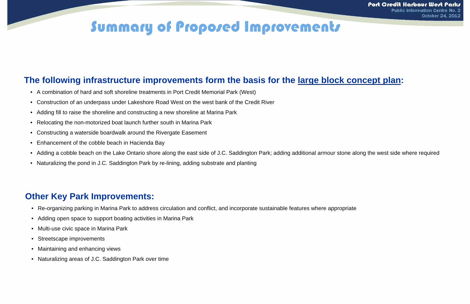
The following infrastructure improvements form the basis for the large block concept plan:• A combination of hard and soft shoreline treatments in Port Credit Memorial Park (West)
• Construction of an underpass under Lakeshore Road West on the west bank of the Credit River
• Adding fill to raise the shoreline and constructing a new shoreline at Marina Park
• Relocating the non-motorized boat launch further south in Marina Park
• Constructing a waterside boardwalk around the Rivergate Easement
• Enhancement of the cobble beach in Hacienda Bay
• Adding a cobble beach on the Lake Ontario shore along the east side of J.C. Saddington Park; adding additional armour stone along the west side where required
• Naturalizing the pond in J.C. Saddington Park by re-lining, adding substrate and planting
Summary of Proposed Improvements
Other Key Park Improvements:• Re-organizing parking in Marina Park to address circulation and conflict, and incorporate sustainable features where appropriate
• Adding open space to support boating activities in Marina Park
• Multi-use civic space in Marina Park
• Streetscape improvements
• Maintaining and enhancing views
• Naturalizing areas of J.C. Saddington Park over time
Port
Cre
dit
Ha
rbou
r Wes
t Pa
rks
Pub
lic In
form
atio
n C
entr
e N
o. 2
Oct
ober
24
, 201
2
Larg
e Bl
ock
Con
cep
t Pl
an

Project Implementation
Potential Impact of Park Infrastructure Improvements City Commitment to Minimizing Potential ImpactsImproved habitat in some areas • Design concepts enhance habitat in many locations
Improved park experience • Improved park connection; water’s edge access incorporated into proposed improvements
Truck traffic associated with fill and/or stone transport • Material deliveries to be scheduled during regular business hours • Traffic control to be used if necessary
Impact on near shore fish habitat • Timing of in-water construction to be scheduled to minimize impacts in fishing
Potential conflict with boating activities • Construction to be scheduled during the non-boating season where possible; boat launching may need to be temporarily moved to Lakefront Promenade Park
• A water use circulation plan to be prepared during detailed design
Dust and noise during construction • Construction to be scheduled during regular business hours• Noise by-laws to be adhered to • Dust management to be put in place where necessary
Limited access to the waterfront and pond during construction • Appropriate signage and fencing to be put in place for safety• Construction to be phased over time and completed as quickly as possible
Potential for spills/sedimentation • Fuelling of construction equipment away from the water• Exposed soils to be covered immediately
Potential for increased wave refraction in Credit River • Addition of cribs and live stakes at Port Credit Memorial Park (West) will minimize the potential for increased wave refraction

Port Credit Harbour West ParksPublic Information Centre No. 2
October 24, 2012
1. Preparation of the Environmental Report.
2. Public review period (30 days) of the Environmental Report.
3. Finalize the Environmental Report.
4. Finalize Large Block Concept Plan.
Key ContactsWork to be Completed Fall 2012 - Winter 2013
Timeline
Jane Darragh, OALA, MCIP, RPP Eha Naylor, OALA, MCIP, RPPPlanner, Park Planning Section Project ManagerParks and Forestry Division Dillon Consulting LimitedCommunity Services Department 235 Yorkland Boulevard Suite 800City of Mississauga Toronto, ON, M2J 4Y8905-615-3200 ext. 4946 416-229-4647 ext. [email protected] [email protected]
www.mississauga.ca/portcreditharbourwestparks
Jan Feb Mar Apr May Jun Jul Aug Sep Oct Nov Dec Jan Understanding the ContextShoreline InvestigationNatural Heritage CharacterizationSite Servicing InvestigationStructural InvestigationIssues and OptionsIdentify Problems/OpportunitiesIdentify Improvement OptionsPublic Information Centre #1Evaluate Improvement OptionsDevelop ConceptsPublic Information Centre #2DocumentationPrepare Environmental Study ReportPrepare Large Block Concept Plan
Next Steps
1. Preparation of the Environmental Report.
2. Public review period (30 days) of the Environmental Report.
3. Finalize the Environmental Report.
4. Finalize Large Block Concept Plan.

• Upgrades could include stone revetment; sea walls; steel sheet piles; and concrete structures
• Less opportunity for naturalization and habitat• Enhance access and visibility of the river and
activities on the river • Design life between 25 to 50 years; likely low
maintenance
Combination
Hard Shore
ALTERNATIVESDo Nothing Natural Shore Hard Shore Combination (Natural and
Hard Shore)
Natural Environment
Socio-Economic and Cultural Environment
Technical
Construction Cost for the Park Area N/A Moderate to High
($600,000)Moderate to High
($600,000)Moderate to High
($600,000)
SummaryThe combination alternative is preferred as it provides the best opportunity to enhance the park for a variety of users and can provide a good mix of hard shore and soft shore to meet the technical needs and the naturalization objectives. The “do nothing” alternative misses out on the opportunity to improve the shoreline use and thus, is least preferred.
Port Credit Memorial Park (West) ShorelinePort Credit Memorial Park (West) ShorelineAlternatives Considered
Do Nothing
Natural Shore
Evaluation of Alternatives
• Existing concrete slab revetments will remain• No changes or impacts to the Natural
Environment • No change or disruption to the Socio-Economic
and Cultural Environment; misses opportunity to improve shoreline use
• Existing structure will continue to deteriorate
• Upgrades include live cribs and live stakes• Softening the shoreline increases potential fish
habitat • Allows for educational components • Protection from wave, river and ice conditions low
to moderate • Design life between 10 to 20 years
• Combination of both natural and hard shore • Habitat opportunities in some areas• Can appeal to a variety of users • Moderate protection provided from wave, river
and ice conditions • Areas with different design life and maintenance
requirements
Least Preferred
Most Preferred
Preferred
LEGEND

Port Credit Memorial Park (West)Port Credit Memorial Park (West)LLarge Block Concept Planarge Block Concept Plan

Port Credit Memorial Park (West) ShorelinePort Credit Memorial Park (West) Shoreline
Shoreline Cross Sections
Section C LAKESHORE ROAD UNDERPASS
Section B1 SOFT SHORE OPTION
Section B3 HARD SHORE OPTION
Section B2 SOFT SHORE OPTION
Section B4 HARD SHORE OPTION
Section B
Section C
Section AA
Section AA BOAT CLUBS - HARD SHORE
Section A2 HARD SHORE OPTION
+-
+-
Section A2
+-
+-
+-
+-

• Indirect crossing at lights will remain• No changes or impacts to the Natural Environment • No change or disruption to the Socio-Economic and
Cultural Environment • Limits continuous circulation between the two parks • Limited technical challenges • Does not provide safe access across Lakeshore
Road West
• Upgrades include concrete ramp under Lakeshore Road with access ramps at both sides
• Potential to negatively impact water quality and fish habitat during construction
• Minimal, if any impact to traffic and park users during construction
• Provides continuous, safer pedestrian connectively between two parks
• Easy to moderate construction• Regular maintenance required
Overpass
Underpass
Least Preferred
ALTERNATIVESDo Nothing At Grade Underpass Overpass
Natural Environment
Socio-Economic and Cultural Environment
Technical
Approximate Cost (Capital) N/A Low($100,000)
Moderate($200,000)
Very High($4,000,000)
SummaryThe underpass is preferred as it provides the needed safe connection with limited construction challenges, moderate maintenance needs and has the least impact on park uses during construction and operation. While the existing condition and at-grade crossing have limited technical challenges and impacts to the Natural Environment, they do not provide the safe access across Lakeshore Road West required to better connect the parks.
Port Credit Memorial Park (West) ConnectionPort Credit Memorial Park (West) ConnectionAlternatives Considered
Do Nothing
At Grade
Evaluation of Alternatives
Most Preferred
Preferred
• Upgrades include lights and a crosswalk • No changes or impacts to the Natural Environment • Limited impact to the community and park users
during construction • Modest improvement to pedestrian connectivity;
some safety concerns remain • Easy to construct• Limited maintenance anticipated
• Upgrades include an overpass with ramps or elevator • No changes or impacts to the Natural Environment • Construction requires temporary closure of existing
pedestrian crossing of the Credit River • Provides continuous, safe pedestrian connectively
between two parks • Access ramps could use valuable park space • Difficult construction• Long-term maintenance required
LEGEND
(Source: City of Burnaby, 2008)
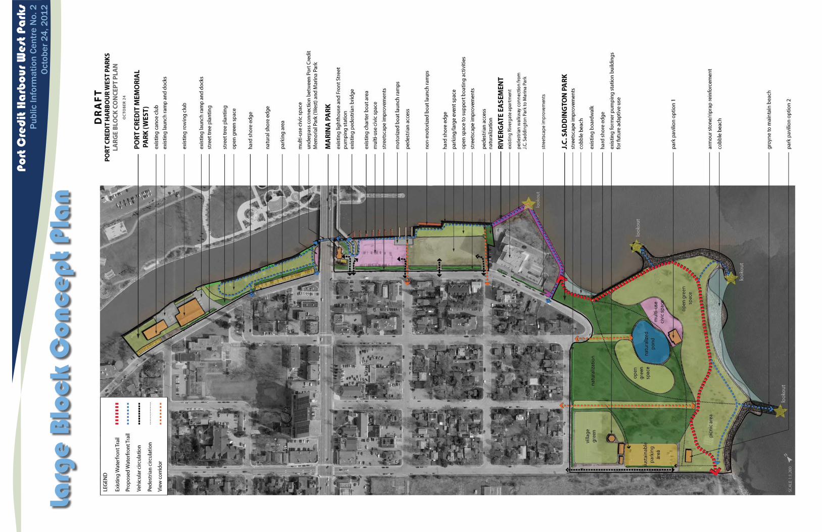
• Raise elevation and improve shore wall throughout
• Opportunity to increase vegetation and landscaping throughout
• Disruption of whole park during construction• Potential for improved off-season programming • Design life 25 to 50 years• Extent of maintenance likely low • 2-3 month longer construction period
Flood Proof North & South Ends
ALTERNATIVESDo Nothing Do Nothing at North End & Flood
Proof South End Flood Proof North & South Ends
Natural Environment
Socio-Economic and Cultural Environment
Technical
Approximate Cost (Capital) N/A Moderate($500,000)
High($1,000,000 to $1,500,000 – not including backshore grading)
SummaryFlood proofing all of Marina Park is preferred in the long term as it allows for year round usability and opportunity for enhancement. Flood proofing in the south end is proposed in the short term. The “do nothing”option is least preferred as sections of the existing shoreline protection have failed.
Marina Park ShorelineMarina Park ShorelineAlternatives Considered
Do Nothing
Do Nothing at North End & Flood Proof South End
Evaluation of Alternatives
• Leave current site layout and programs• No changes or opportunity to improve the Natural
Environment • Potential for park areas to flood and south end of
park will continue to erode• Current site layout and functions are not
welcoming to non-fishing community and tourists
• Raise elevation and improve shore wall at south end • Opportunity to increase vegetation and landscaping
where elevation is raised • Minimal disruption at north end during construction• Design life 25 to 50 years• Extent of maintenance is likely low
Least Preferred
Most Preferred
Preferred
LEGEND

Marina Park & Marina Park & RivergateRivergate EasementEasementLLarge Block Concept Planarge Block Concept Plan

Marina Park ShorelineMarina Park Shoreline
Shoreline Cross Sections
Section D1 EXISTING SHORE WALL WITH NEW CAP
Section D
Section ESections F1
Section F1 and/or F3
Section E EXISTING LAUNCH RAMP
Section F1 MARINA PARK SHORELINE Section F2 NON-MOTORIZED LAUNCH Section F3 MARINA PARK SHORELINE*
+-
Sections F2
*hard shore required for stabilization but is naturalized where possible
Section D2 PROPOSED SHORE WALL WITH NEW CAP

• Development of an elevated fixed walkway along the shore
• Increased turbidity and sedimentation in Credit River during construction
• Significant improvement in continuous connectivity along the water’s edge between J.C. Saddington Park and Marina Park
• Enhances the waterfront trail experience • Design life 25 to 50 years; maintenance
would be required
Shoreline Connection
ALTERNATIVESDo Nothing/Enhance Streetscape Link Shoreline Connection
Natural Environment
Socio-Economic and Cultural Environment
Technical
Construction Cost for the Park Area Low ($150,000)
High($2,500,000)
Summary The shoreline connection is preferred as it enhances the experience for trail users and provides some opportunity for aquatic habitat enhancement.
Rivergate Easement Pedestrian Rivergate Easement Pedestrian ConnectionConnection
Alternatives ConsideredDo Nothing/Enhance Streetscape Link
Evaluation of Alternatives
• Enhancement of streetscape link; improve signage
• No changes to the Natural Environment including no opportunity to increase naturalization
• Away from water’s edge• Minimal maintenance required
Least Preferred
Most Preferred
Preferred
LEGEND
(Source: Steve Creek, 2010)
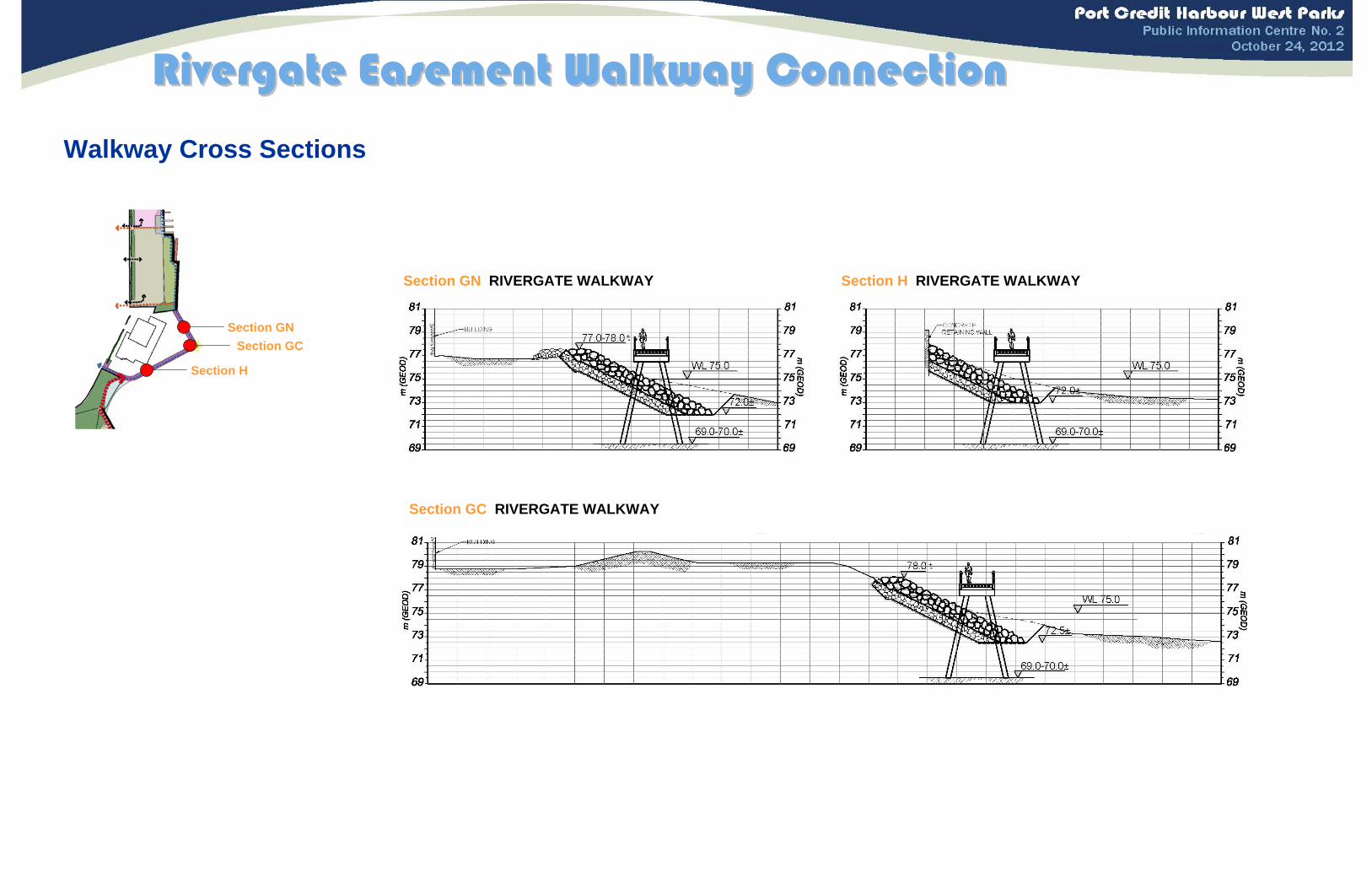
Rivergate Easement Walkway ConnectionRivergate Easement Walkway Connection
Walkway Cross Sections
Section GNSection GC
Section H
Section GN RIVERGATE WALKWAY Section H RIVERGATE WALKWAY
Section GC RIVERGATE WALKWAY
+-
+-

• Existing stacked and rough random placed armour stone remains
• No changes or impacts to the Natural Environment • No change or disruption to the Socio-Economic and
Cultural Environment however, it misses out on the opportunity to enhance the park and waterfront
• Existing shoreline only provides a moderate level of protection
• Upgrades include placement of cobble where suitable and improved revetment through remainder
• Greater enhancement of riparian vegetation and potential to improve wildlife habitat
• Safer access to the water’s edge • Allows for some flexibility in
programming• Design life 25 to 50 years; beach will
require ongoing maintenance • A cobble beach is feasible at the
location given the water depths and wave exposure
Cobble Beach
ALTERNATIVESDo Nothing Improve Existing Cobble Beach
Natural Environment
Socio-Economic and Cultural Environment
Technical
Approximate Cost (Capital) Low and Periodic Moderate to High($550,000)
High($3,000,000)
Summary Including a cobble beach, where appropriate, is preferred as it allows for the creation of diversity in wildlife habitat and provides improved safe access to the water’s edge.
J.C. Saddington Park ShorelineJ.C. Saddington Park ShorelineAlternatives Considered
Do Nothing
Improve Existing
Evaluation of Alternatives
• Upgrades include placement of stone in upper parts of revetment
• Enhancement of riparian cover in selected areas; potential to improve wildlife habitat
• No change in access to water’s edge • Design life 25 to 50 years; low maintenance requirements
Least Preferred
Most Preferred
Preferred
LEGEND
(Source: Terry McDonald, 2010)

J.C. Saddington ParkJ.C. Saddington ParkLLarge Block Concept Planarge Block Concept Plan

+-
J.C. Saddington Park ShorelineJ.C. Saddington Park Shoreline
Shoreline Cross Sections
Section I
Section LSection N
Section I COBBLE BEACH
Section N HARD SHORESection M1 GROYNE
Section L COBBLE BEACH
Section M2 GROYNE
+-
Section M1 & M2

• Maintaining urban water features (e.g. wading pool, skating rink); adding landscaping around the pond
• Landscaping would provide limited improvement to wildlife habitat and function
• Provides significant flexibility for programming
• Provides an opportunity to incorporate cultural heritage themes
• Shorter design life and potentially more maintenance (between seasons)
• Improvements to existing pond infrastructure would be needed
Urban/Concrete
Least Preferred
ALTERNATIVESDo Nothing Naturalized Urban/Concrete
Natural Environment
Socio-Economic and Cultural Environment
Technical
Construction Cost for the Park Area N/A Moderate
($400,000)
Moderate($400,000*)
*cost may vary depending on design features
Summary A naturalized pond is preferred as it provides improved habitat and an opportunity to introduce a natural area into the Port Credit Waterfront.
J.C. Saddington Park PondJ.C. Saddington Park Pond
Alternatives Considered
Naturalized
Evaluation of Alternatives
Most Preferred
Preferred
• Altering surfaces and depths, and re-lining of pond to support naturalized environment
• Vegetation and plantings in and around the pond to promote a naturalized system and increase wildlife habitat and function
• Provides some opportunity to improve water quality • Does not provide an opportunity to improve the cultural
heritage character • Longer design life and potentially less maintenance
LEGEND
Do Nothing • Existing pond will remain • No changes or impacts to the Natural Environment • No change or disruption to the Socio-Economic and Cultural
Environment
(Source: www.melanieotg.ca, 2011)
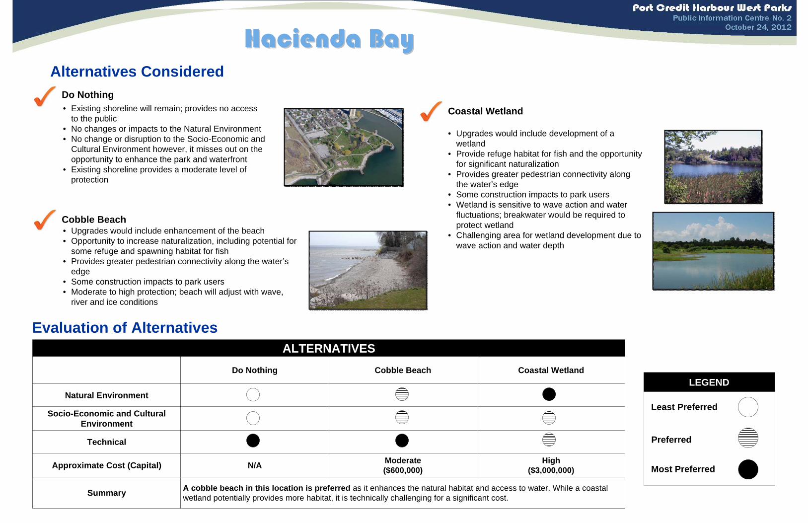
• Existing shoreline will remain; provides no access to the public
• No changes or impacts to the Natural Environment • No change or disruption to the Socio-Economic and
Cultural Environment however, it misses out on the opportunity to enhance the park and waterfront
• Existing shoreline provides a moderate level of protection
• Upgrades would include development of a wetland
• Provide refuge habitat for fish and the opportunity for significant naturalization
• Provides greater pedestrian connectivity along the water’s edge
• Some construction impacts to park users • Wetland is sensitive to wave action and water
fluctuations; breakwater would be required to protect wetland
• Challenging area for wetland development due to wave action and water depth
Coastal Wetland
ALTERNATIVESDo Nothing Cobble Beach Coastal Wetland
Natural Environment
Socio-Economic and Cultural Environment
Technical
Approximate Cost (Capital) N/A Moderate ($600,000)
High($3,000,000)
Summary A cobble beach in this location is preferred as it enhances the natural habitat and access to water. While a coastal wetland potentially provides more habitat, it is technically challenging for a significant cost.
Hacienda BayHacienda BayAlternatives Considered
Do Nothing
Cobble Beach
Evaluation of Alternatives
• Upgrades would include enhancement of the beach • Opportunity to increase naturalization, including potential for
some refuge and spawning habitat for fish • Provides greater pedestrian connectivity along the water’s
edge • Some construction impacts to park users • Moderate to high protection; beach will adjust with wave,
river and ice conditions
Least Preferred
Most Preferred
Preferred
LEGEND

• Current location at Marina Park • No changes or impacts to the Natural Environment • No change or disruption to the Socio-Economic and
Cultural Environment • Sheltered from waves; potential for boat generated
waves
• Move non-motorized boat launch to Port Credit Memorial Park (West)
• Decreased opportunity for areas of naturalization • Increase vehicular traffic on Front Street North• Decreased congestion and conflicts between motorized
and non-motorized boats in Marina Park• Sheltered from open lake; small potential for boat
generated waves• Potential conflict with clubs
Hacienda Bay
Port Credit Memorial Park (West)
Least Preferred
ALTERNATIVESDo Nothing Marina Park Port Credit Memorial Park
(West) Hacienda Bay
Natural Environment
Socio-Economic and Cultural Environment
Technical
Approximate Cost (Capital) N/A Low($50,000)
Low($50,000)
Low($50,000*)
*cost may vary depending on Hacienda Bay design details
Summary A separate non-motorized boat launch at Marina Park is the preferred alternative as it has the potential to improve the current on-land conflicts and keeps the boating use in Marina Park.
NonNon--Motorized Boat LaunchMotorized Boat LaunchAlternatives Considered
Do Nothing
Marina Park
Evaluation of Alternatives
Most Preferred
Preferred
• Separate non-motorized boat launch location at Marina Park
• Increased turbidity and sedimentation during construction• Reducing congestion and conflict on site • Requires shore parallel floating dock
• Move non-motorized boat launch to Hacienda Bay• Decreased opportunity for areas of naturalization • Closer to parking but park space needed for loading and
drop-off• Decreased congestion and conflicts between motorized
and non-motorized boats in Marina Park• Semi-sheltered from open lake; greater exposure to wave
action
LEGEND