Embed Size (px)
Citation preview
!
!
!
!
!
!
!
!
!
!
!
!!
!! ! ! ! ! !
!!
!!
!
!
!
!
!
!
!
!
!
!
!
!
!
!!
!!
!!
!!
!!
!!
!
!
!
!
!
!
!
!
!
!
!
!
!
!
!
!!
!!
!!!!!!
!!
!
!
!
!
!
!
!
!
!
!
!
!
!
!
!!
!!
!!
!!
!!
!!
!
!
!
!
!!
!!
!!
!!
!!
!!
!!
!!
!!
!!
!!
!!
!!
!!
!!
! !!
!!
!!
!!
!!
!!
!!
!!
!!
!!
!!
!!
!!
!!
!!
!!
!!
!!
!!
!!
!!
!!
!!
!!
!!
!!
!!
!!
!!
!!
!!
!!
!!
! !!
!!
!!
!!
!!
!!
!!
!!
!!
!!
!!
!!
!!
!!
!!
!
!!
!!
!!
!!
!!
!!
!!
!!
!!
!!
!!
!!
!!
!!
!!
!!
!!
!!
!!
!!
!!
!!
!!
!!
!!
!!
!!
!!
!!
!!
!!
!!
!!
!!
!
!
!
!
!!
!!
! ! ! !!
!!
!
!
!
!
!
!
!
!
!
!
!
!
!
!!
!!
!!
!!
!!
!!
!
!
!
!
!
!
!
!
!
!
!
!
!
!
!!
!!!!!!
!!
!
!
!
!
!
!
!
!
!
!
!
!
!!
!!
!!
!!
!!
!!
!
!
!
!
!
!
!
!
!
!
Ð
Ð
ÐÐÐÐÐ Ð
Ð
Ð
Ð
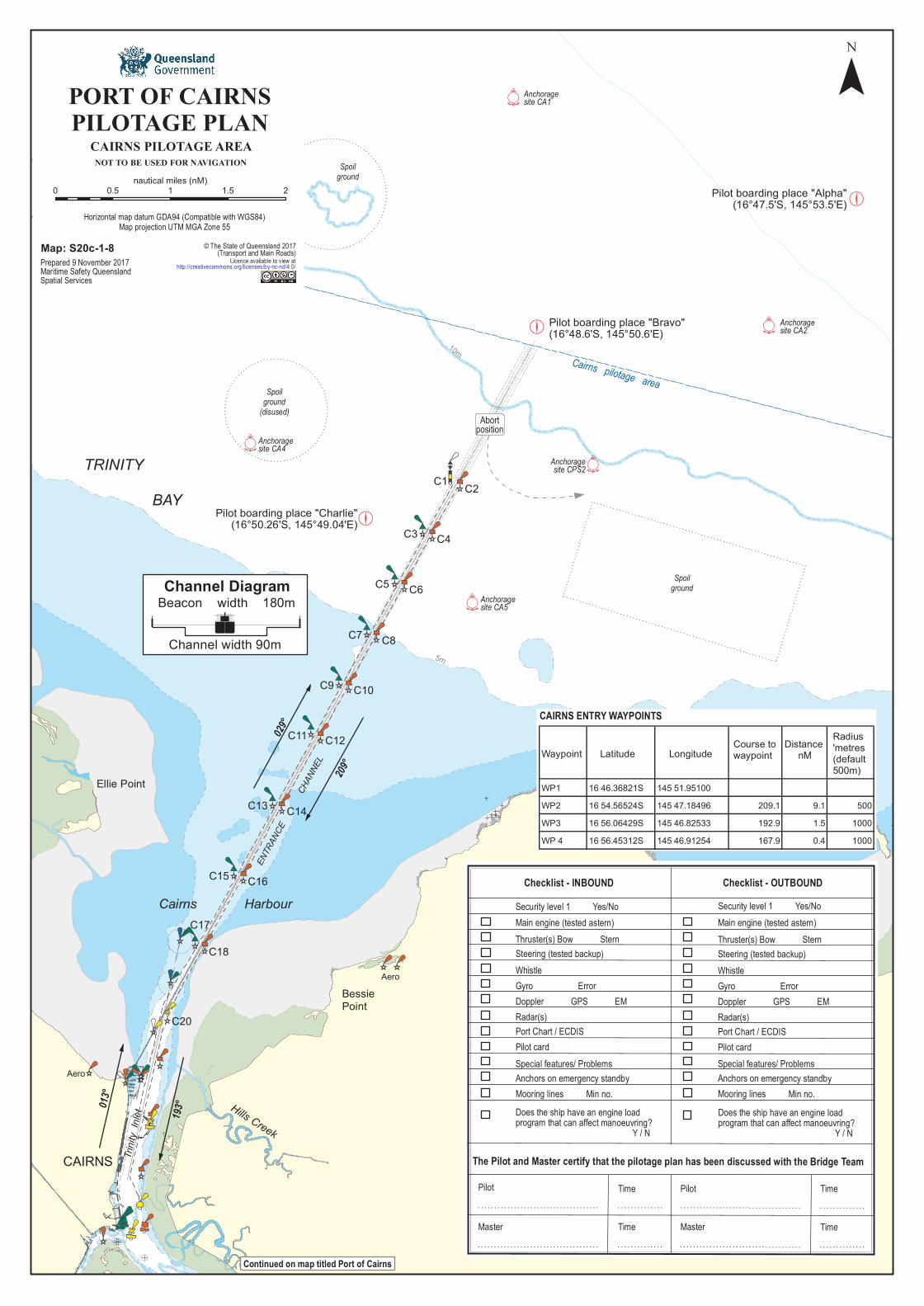
Cairns pilotage area
Pilot boarding place "Bravo"(16°48.6'S, 145°50.6'E)
TRINITY BAY
False Cape
BessiePoint
Hills Creek
Trinit
y Inl
et
CAIRNS
Ellie Point
Cairns Harbour
C20
C18
C17
C16C15
C14C13
C12C11
C10C9
C8C7
C6C5
C4C3
C2C1
029°
209°
ENTR
ANCE
C
HANN
EL
193°013
°
Spoilground
(disused)
Spoilground
10m
5m
Aero
Abortposition
Anchoragesite CA5
Anchoragesite CA4Anchoragesite CPS2
Pilot boarding place "Charlie"(16°50.26'S, 145°49.04'E)
Spoilground
Anchoragesite CA1
Anchoragesite CA2
Pilot boarding place "Alpha"(16°47.5'S, 145°53.5'E)
Aero
¯
Map: S20c-1-8Prepared 9 November 2017Maritime Safety QueenslandSpatial Services
© The State of Queensland 2017(Transport and Main Roads)Licence available to view athttp://creativecommons.org/licenses/by-nc-nd/4.0/
Channel DiagramBeacon width 180m
Channel width 90m
0 0.5 1 1.5 2nautical miles (nM)
PORT OF CAIRNSPILOTAGE PLAN
CAIRNS PILOTAGE AREANOT TO BE USED FOR NAVIGATION
Horizontal map datum GDA94 (Compatible with WGS84)Map projection UTM MGA Zone 55
WaypointRadius'metres(default500m)
Distance nM
Course towaypointLongitudeLatitude
CAIRNS ENTRY WAYPOINTS
Continued on map titled Port of Cairns
! ! ! ! ! ! ! ! ! ! ! ! ! ! ! ! ! ! ! ! ! ! ! ! ! ! ! ! ! ! ! ! ! ! ! ! !
! ! ! ! ! ! ! ! ! ! ! ! ! ! ! ! ! ! ! ! ! ! ! ! ! ! ! ! ! ! ! ! ! ! ! ! !
! ! ! ! ! ! ! ! ! ! ! ! ! !
! ! ! ! ! ! ! ! ! ! ! ! ! !
! ! ! ! ! ! ! ! ! ! ! ! ! ! ! ! ! ! ! ! ! ! ! ! ! ! ! ! ! ! ! ! ! ! ! ! !
! ! ! ! ! ! ! ! ! ! ! ! ! ! ! ! ! ! ! ! ! ! ! ! ! ! ! ! ! ! ! ! ! ! ! ! ! ! ! ! ! ! ! ! ! ! ! ! ! ! !
! ! ! ! ! ! ! ! ! ! ! ! ! !
Pilot
Master
Time
Time
Time
Time
Pilot
Master
The Pilot and Master certify that the pilotage plan has been discussed with the Bridge Team
Does the ship have an engine loadprogram that can affect manoeuvring? Y / N
Checklist - INBOUND Checklist - OUTBOUND
Main engine (tested astern)Thruster(s) Bow SternSteering (tested backup)WhistleGyro ErrorDoppler GPS EMRadar(s)Port Chart / ECDISPilot cardSpecial features/ ProblemsAnchors on emergency standbyMooring lines Min no.
Main engine (tested astern)Thruster(s) Bow SternSteering (tested backup)WhistleGyro ErrorDoppler GPS EMRadar(s)Port Chart / ECDISPilot cardSpecial features/ ProblemsAnchors on emergency standbyMooring lines Min no.
Security level 1 Yes/No Security level 1 Yes/No
Does the ship have an engine loadprogram that can affect manoeuvring? Y / N
WP1 16 46.36821S 145 51.95100WP2 16 54.56524S 145 47.18496 209.1 9.1 500WP3 16 56.06429S 145 46.82533 192.9 1.5 1000WP 4 16 56.45312S 145 46.91254 167.9 0.4 1000

C20
T1
T2
T4
T6
T8
Cairns Harbour
Marlin Marina
Hills Creek
StaffordPoint
Magazine Creek
Firewood Creek
Trinity Inlet
SenrabPoint
PORTSMITH
CAIRNSCITY
Leadin
g light
s 013°
03' (T
)
0m
2m 5m
0m
2m
5m
10m
5m2m
Fl Y 1.5s
Q (F day) Occas& Fl Y 4s
Fl R 2.5sFR
Dir Iso 4s WRG18m 11M FRFG
Fl R 4s
Fl R 1.5s
Fl Y 2.5s
Fl R 3sFl Y 3s
Fl R 2.5s
FGFR
AdmiraltyIsland
Small craftanchorages
Small craft anchorage area
8.3m
8.3m
193°
10.5m
6.0m
9.3m
10.0m
8.4m
6.3m
3.3m
9.3m
8.4m8.4m8.4m
8.4m8.4m
T10
Fl Y 4s
S2T7
Buoysmarkslipway
013°
Aero
Small craft
anchorage area
Tropical ReefSlipway
HMAS Cairns
BSE CairnsSlipway
Fl G 5s
Smith
s Cree
k
C18Fl R 4sC17
Fl G 4sHarbour rear leadF Bu & Fl G 3s
Harbour front leadF Bu & Fl G 3s
12
3
54
678
11
10
12
Sailfis
h Quay
Marlin
Whar
f
¯
PORT OF CAIRNSVessel .....................................................
PILOTAGE PLAN - ARRIVAL
PORT OF CAIRNSVessel .....................................................
PILOTAGE PLAN - REMOVAL/DEPARTURECairns VTS listens continuously on VHF 12 VHF 16.Should any emergency arise, call Cairns VTS on VHF 12 for assistance.The bridge team will be required to plot vessel's position as required byMaritime Safety Queensland and International Regulations.The pilotage passage will be monitored by VTS Cairns.
PORT OF CAIRNS0 0.1 0.2 0.3 0.4 0.5
nautical miles (nM)
Prepared 9 November 2017Maritime Safety QueenslandSpatial Services
Cairns VTS listens continuously on VHF 12 VHF 16.Should any emergency arise, call Cairns VTS on VHF 12 for assistance.The bridge team will be required to plot vessel's position as required byMaritime Safety Queensland and International Regulations.The pilotage passage will be monitored by VTS Cairns.
Continued on map titled Port of Cairns pilotage plan
Continued on map titled Smiths Creek Continued on map titled Trinity Inlet
Map: S20c-1-8 reverse
Mooring lines
1 - 6 10°27.28'/190°27.28'7 - 8 10°15.52'/190°15.52'10 3°58.53'/ 183°58.53'12 351°35.25' /171°35.25'
Sailfish Quay 5 - 7 12°41.67'/192°41.67'
Berth Headings
0.9m or10% of draft if it is greater
Fairway Harbour
LAT+ Tide
Avl Water- Draft
UKC
PilotDatePassage
Draft in metres
Berth
Wind
TideF ATime Height
DIR SPRemarks:
Minimum UKC
TugsDefectsPilot card yes no
yes noBollard pull Position
Channels (VHF)
Tide Time Height
Vessels up to 30000GRT
Vessels over 90000GRTVessels over 40000GRTVessels up to 40000GRT
2.0m1.5m1.3m
PropulsionTuskerGiru
47T47T
Az.D.Az.D.
0.6mSwing Basin
16 - 12 - 6
GaboWoona 47T
47T Az.D.Az.D.
FairwayHarbour
LAT+ Tide
Avl Water- Draft
UKC
PilotDatePassage
Wind
TideF ATime Height
DIR SPRemarks:
TugsDefectsPilot card yes no
yes noBollard pull Position
Channels (VHF)
Tide Time Height
PropulsionTuskerGiru
47T47T
Az.D.Az.D.Draft in metres
Minimum UKC
Vessels up to 30000GRT
Vessels over 90000GRTVessels over 40000GRTVessels up to 40000GRT
2.0m1.5m1.3m0.9m or
10% of draft if it is greater0.6mSwing Basin
16 - 12 - 6
WoonaGabo
47T47T
Az.D.Az.D.
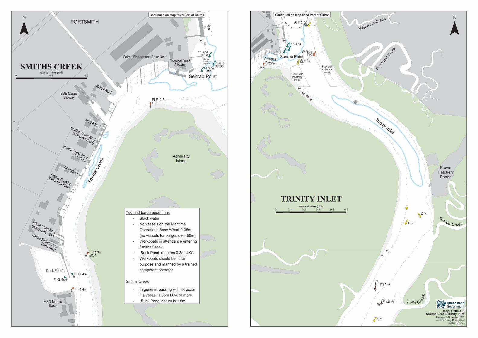
Trinity Inlet
SmithsCreek
Magazine Creek
Firewood
Creek
Fall s C reek
Seelee C reek
Fl R 3s
Fl Y 3sT7
T10
T8Fl Y 2.5s
S2Small craftanchorage
areas
Small craftanchorage
areas
Q Y
Q Y
Fl (2) 15s
Q Y
Fl (2) 4s
Praw nHatcheryPon ds
Sen rab Poin t
Fl G 5s
Sen rab Poin t
PORTSMITH
Fl R 2.5s
Adm iraltyIslan d
Smiths
Cree
k
12 10.5m
S2
BuoysmarkslipwayTropical ReefSlipway
BSE CairnsSlipway
Fl G 5s
Fl G 5s
Fl G 5s
Cairns Fishermans Base No 1
NQEA No 1
NQEA No 2Smiths Creek No 1(Masons Wharf)Smiths Creek No 2(C C Con)
DPI WharfCairns CruisingYacht Squadron
Barge ramp No 2Cairns FishermansBase No 2
Barge ramp No 1
'Duck Pond'
MSQ MarineBase
Fl R 3sSC4
Fl G 4sFl G 4s
Fl R 4s
TRS5
TRS1
TRS3
¯ ¯
Tug an d barge operation s - Slack water - No vessels on the Maritim e Operation s Base Wharf 0-35m (n o vessels for barges over 50m )
- Workboats in atten dan ce en terin g Sm ith s Creek
- ‘Duck Pon d’ requires 0.3m U KC - Workboats should be fit for purpose an d m an n ed by a train ed com peten t operator.
Sm ith s Creek - In gen eral, passin g will n ot occur if a vessel is 35m LOA or m ore.
- ‘Duck Pon d’ datum is 1.5m
Continued on map titled Port of Cairns Continued on map titled Port of Cairns
Prepared 9 November 2017Maritime Safety Queensland
Spatial Services
Map: S20c-1-8Smiths Creek/Trinity Inlet
SMITHS CREEK0 0.1 0.2
n autical m iles (n M)
TRINITY INLET0 0.1 0.2 0.3 0.4 0.5
n autical m iles (n M)