Embed Size (px)
Citation preview
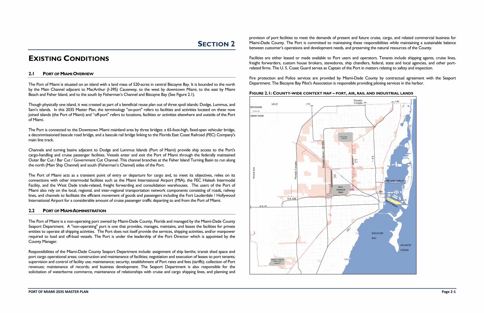
PORT OF MIAMI 2035 MASTER PLAN Page 2-1
SECTION 2
EXISTING CONDITIONS
2.1 PORT OF MIAMI OVERVIEW
The Port of Miami is situated on an island with a land mass of 520-acres in central Biscayne Bay. It is bounded to the north
by the Main Channel adjacent to MacArthur (I-395) Causeway, to the west by downtown Miami, to the east by Miami
Beach and Fisher Island, and to the south by Fisherman’s Channel and Biscayne Bay (See Figure 2.1).
Though physically one island, it was created as part of a beneficial reuse plan out of three spoil islands: Dodge, Lummus, and
Sam’s islands. In this 2035 Master Plan, the terminology "on-port" refers to facilities and activities located on these now
joined islands (the Port of Miami) and “off-port" refers to locations, facilities or activities elsewhere and outside of the Port
of Miami.
The Port is connected to the Downtown Miami mainland area by three bridges: a 65-foot-high, fixed-span vehicular bridge,
a decommissioned bascule road bridge, and a bascule rail bridge linking to the Florida East Coast Railroad (FEC) Company's
main line track.
Channels and turning basins adjacent to Dodge and Lummus Islands (Port of Miami) provide ship access to the Port's
cargo-handling and cruise passenger facilities. Vessels enter and exit the Port of Miami through the federally maintained
Outer Bar Cut / Bar Cut / Government Cut Channel. This channel branches at the Fisher Island Turning Basin to run along
the north (Main Ship Channel) and south (Fisherman’s Channel) sides of the Port.
The Port of Miami acts as a transient point of entry or departure for cargo and, to meet its objectives, relies on its
connections with other intermodal facilities such as the Miami International Airport (MIA), the FEC Hialeah Intermodal
Facility, and the West Dade trade-related, freight forwarding and consolidation warehouses. The users of the Port of
Miami also rely on the local, regional, and inter-regional transportation network components consisting of roads, railway
lines, and channels to facilitate the efficient movement of goods and passengers including the Fort Lauderdale / Hollywood
International Airport for a considerable amount of cruise passenger traffic departing to and from the Port of Miami.
2.2 PORT OF MIAMI ADMINISTRATION
The Port of Miami is a non-operating port owned by Miami-Dade County, Florida and managed by the Miami-Dade County
Seaport Department. A "non-operating" port is one that provides, manages, maintains, and leases the facilities for private
entities to operate all shipping activities. The Port does not itself provide the services, shipping activities, and/or manpower
required to load and off-load vessels. The Port is under the leadership of the Port Director which is appointed by the
County Manager.
Responsibilities of the Miami-Dade County Seaport Department include: assignment of ship berths; transit shed space and
port cargo operational areas; construction and maintenance of facilities; negotiation and execution of leases to port tenants;
supervision and control of facility use; maintenance; security; establishment of Port rates and fees (tariffs); collection of Port
revenues; maintenance of records; and business development. The Seaport Department is also responsible for the
solicitation of waterborne commerce, maintenance of relationships with cruise and cargo shipping lines, and planning and
provision of port facilities to meet the demands of present and future cruise, cargo, and related commercial business for
Miami-Dade County. The Port is committed to maintaining these responsibilities while maintaining a sustainable balance
between customer’s operations and development needs, and preserving the natural resources of the County.
Facilities are either leased or made available to Port users and operators. Tenants include shipping agents, cruise lines,
freight forwarders, custom house brokers, stevedores, ship chandlers, federal, state and local agencies, and other port-
related firms. The U. S. Coast Guard serves as Captain of the Port in matters relating to safety and inspection.
Fire protection and Police services are provided by Miami-Dade County by contractual agreement with the Seaport
Department. The Biscayne Bay Pilot's Association is responsible providing piloting services in the harbor.
FIGURE 2.1: COUNTY-WIDE CONTEXT MAP – PORT, AIR, RAIL AND INDUSTRIAL LANDS
PORT OF MIAMI 2035 MASTER PLAN Page 2-2
2.3 LAND USES
Land uses are established by Miami-Dade County or the adjacent Municipalities. They are all reflected in the County’s
Comprehensive Land Use Plan. The entire Port is classified as “Terminal” which allows for a broad range of uses and
activities.
This section provides an inventory of existing land uses in areas immediately adjacent to the Port and existing internal land
uses within each of the Port's functional areas. An inventory and analysis of shoreline uses and conflicts, the need for water-
dependent and water-related uses, and areas in need of redevelopment are also provided.
2.3.1 URBAN CONTEXT AND SURROUNDING LAND USES
The Port of Miami is the primary water-dependent land use in Downtown Miami, occupying a prominent location
immediately east of the Miami Central Business District (CBD).
The pattern of land uses surrounding the Port of Miami is characterized as a mixture of low, medium, and high-density
residential, commercial, office, and park / recreation uses (See Figure 2.2).
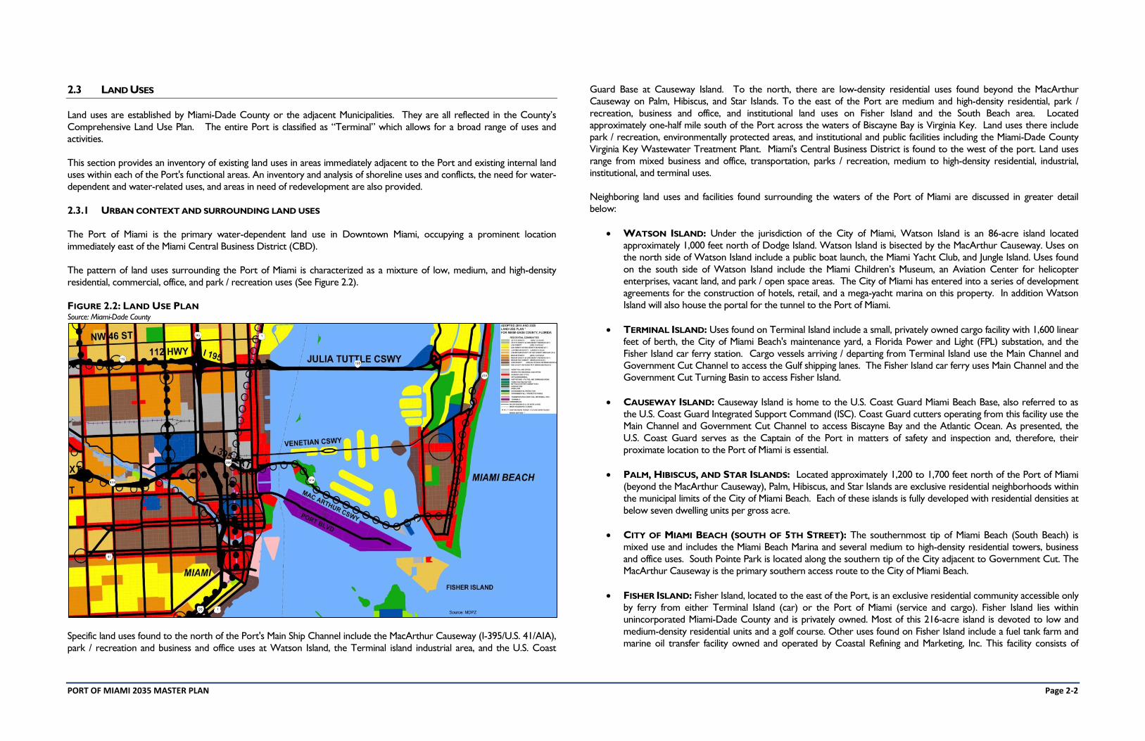
FIGURE 2.2: LAND USE PLAN Source: Miami-Dade County
Specific land uses found to the north of the Port's Main Ship Channel include the MacArthur Causeway (I-395/U.S. 41/AIA),
park / recreation and business and office uses at Watson Island, the Terminal island industrial area, and the U.S. Coast
Guard Base at Causeway Island. To the north, there are low-density residential uses found beyond the MacArthur
Causeway on Palm, Hibiscus, and Star Islands. To the east of the Port are medium and high-density residential, park /
recreation, business and office, and institutional land uses on Fisher Island and the South Beach area. Located
approximately one-half mile south of the Port across the waters of Biscayne Bay is Virginia Key. Land uses there include
park / recreation, environmentally protected areas, and institutional and public facilities including the Miami-Dade County
Virginia Key Wastewater Treatment Plant. Miami's Central Business District is found to the west of the port. Land uses
range from mixed business and office, transportation, parks / recreation, medium to high-density residential, industrial,
institutional, and terminal uses.
Neighboring land uses and facilities found surrounding the waters of the Port of Miami are discussed in greater detail
below:
WATSON ISLAND: Under the jurisdiction of the City of Miami, Watson Island is an 86-acre island located
approximately 1,000 feet north of Dodge Island. Watson Island is bisected by the MacArthur Causeway. Uses on
the north side of Watson Island include a public boat launch, the Miami Yacht Club, and Jungle Island. Uses found
on the south side of Watson Island include the Miami Children’s Museum, an Aviation Center for helicopter
enterprises, vacant land, and park / open space areas. The City of Miami has entered into a series of development
agreements for the construction of hotels, retail, and a mega-yacht marina on this property. In addition Watson
Island will also house the portal for the tunnel to the Port of Miami.
TERMINAL ISLAND: Uses found on Terminal Island include a small, privately owned cargo facility with 1,600 linear
feet of berth, the City of Miami Beach's maintenance yard, a Florida Power and Light (FPL) substation, and the
Fisher Island car ferry station. Cargo vessels arriving / departing from Terminal Island use the Main Channel and
Government Cut Channel to access the Gulf shipping lanes. The Fisher Island car ferry uses Main Channel and the
Government Cut Turning Basin to access Fisher Island.
CAUSEWAY ISLAND: Causeway Island is home to the U.S. Coast Guard Miami Beach Base, also referred to as
the U.S. Coast Guard Integrated Support Command (ISC). Coast Guard cutters operating from this facility use the
Main Channel and Government Cut Channel to access Biscayne Bay and the Atlantic Ocean. As presented, the
U.S. Coast Guard serves as the Captain of the Port in matters of safety and inspection and, therefore, their
proximate location to the Port of Miami is essential.
PALM, HIBISCUS, AND STAR ISLANDS: Located approximately 1,200 to 1,700 feet north of the Port of Miami
(beyond the MacArthur Causeway), Palm, Hibiscus, and Star Islands are exclusive residential neighborhoods within
the municipal limits of the City of Miami Beach. Each of these islands is fully developed with residential densities at
below seven dwelling units per gross acre.
CITY OF MIAMI BEACH (SOUTH OF 5TH STREET): The southernmost tip of Miami Beach (South Beach) is
mixed use and includes the Miami Beach Marina and several medium to high-density residential towers, business
and office uses. South Pointe Park is located along the southern tip of the City adjacent to Government Cut. The
MacArthur Causeway is the primary southern access route to the City of Miami Beach.
FISHER ISLAND: Fisher Island, located to the east of the Port, is an exclusive residential community accessible only
by ferry from either Terminal Island (car) or the Port of Miami (service and cargo). Fisher Island lies within
unincorporated Miami-Dade County and is privately owned. Most of this 216-acre island is devoted to low and
medium-density residential units and a golf course. Other uses found on Fisher Island include a fuel tank farm and
marine oil transfer facility owned and operated by Coastal Refining and Marketing, Inc. This facility consists of
PORT OF MIAMI 2035 MASTER PLAN Page 2-3
approximately ten acres of land containing fifteen above-ground fuel storage tanks. Coastal provides fuel bunkering
services (barge or truck) for ships berthing at the Port of Miami and the private terminals found along the Miami
River.
VIRGINIA KEY is located approximately one half mile south of the Port; this is an 863-acre island under the
jurisdiction of the City of Miami and Miami-Dade County. This island contains a variety of public and private land
uses including the Miami-Dade County Central District Wastewater Treatment Plant, a spoil disposal area
previously used for port dredge material, the Bill Sadowski Critical Wildlife Area, Rosenstiel School of Marine, and
Atmospheric Science, Mast Academy, restaurants, marinas, and the Miami Seaquarium parks and recreation areas.
The Bill Sadowski Critical Wildlife Area, at its nearest point, is located more than 100 feet southeast of South
Channel. This area serves as a refuge for migrating birds and is a special manatee protection area. This is further
discussed in the later Environmental section of the report.
DOWNTOWN MIAMI'S CENTRAL BUSINESS DISTRICT (CBD) is characterized by four neighborhoods: Central
Business, Brickell, Park West, and Media and Entertainment. These areas are proximate to the port and include
Bicentennial and Bayfront Parks, Flagler Street, PAC, American Airlines Arena, Government Center, and Mary
Brickell Village.
BAYSIDE MARKETPLACE is a retail and entertainment complex located on a City of Miami-owned waterfront site
adjacent to Bayfront Park. Its 235,000-square-feet of leasable area are devoted to food and specialty retailing. The
Bayside complex also includes the 200-slip Miami Marina. Bayside Marketplace is a significant destination for visitors
to South Florida, including cruise ship passengers and crew passing through the Port of Miami.
AMERICAN AIRLINES ARENA is located at the entrance to the Port and is the home for the Miami Heat, as well
as a venue for a variety of other entertainment activities such as concerts. The arena seats 20,000 people and can
accommodate 1,200 cars in the underground parking garage.
BICENTENNIAL PARK was built in the 1970s on the site of the Port's original waterfront location. Since its
dedication in 1976, the park has remained largely underutilized and has been inadequately maintained. This area is
now reprogrammed to be “Museum Park” and the future home of several major museums.
BISCAYNE BOULEVARD CONDOMINIUM DEVELOPMENTS includes more than 2,000 new residential units in
buildings on the west side of Biscayne Boulevard across from Bicentennial Park, American Airlines Arena, and
Bayfront Park. Downtown Miami has developed many new residential buildings over the past ten years with the
opening of several major properties adjacent to the Port of Miami within the downtown core. They include 50
Biscayne, Marquis, Ten Museum, 900 Biscayne, Marina Blue, and others to the south and north along the same
roadway and throughout the downtown area.
THE MIAMI RIVER’S mouth enters Biscayne Bay just southwest of the Port of Miami. Vessels plying their trade to
and from the Miami River must access through the South Channel or via the lntracoastal Waterway. As the
administrator of waterborne commerce for Miami-Dade County, the Seaport Department has an affiliated interest
in the Miami River. The Miami River Commission, acting as the official clearinghouse for public policy and projects
relating to the river, has spearheaded efforts to improve and maintain the river. Ongoing Miami River projects
include the Miami River Greenway, continuation of dredge and cleaning of the river’s tributaries, and maintaining
the mixed-use nature of the river.
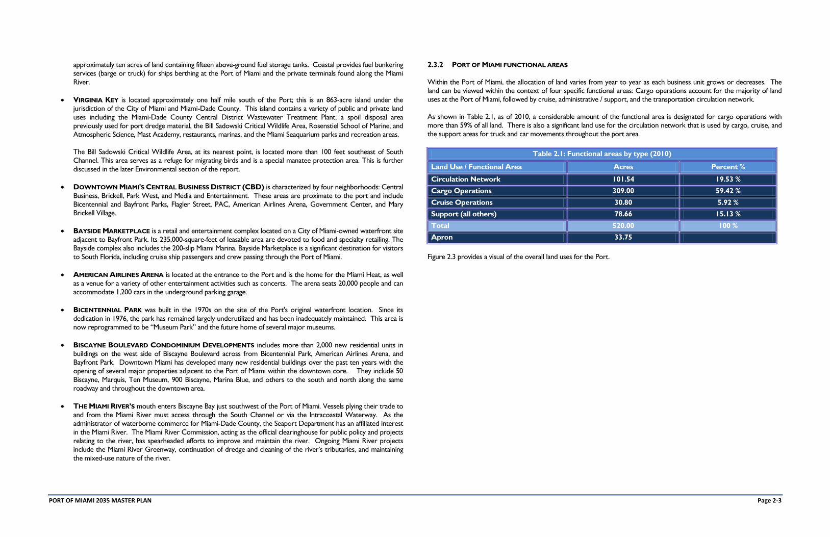
2.3.2 PORT OF MIAMI FUNCTIONAL AREAS
Within the Port of Miami, the allocation of land varies from year to year as each business unit grows or decreases. The
land can be viewed within the context of four specific functional areas: Cargo operations account for the majority of land
uses at the Port of Miami, followed by cruise, administrative / support, and the transportation circulation network.
As shown in Table 2.1, as of 2010, a considerable amount of the functional area is designated for cargo operations with
more than 59% of all land. There is also a significant land use for the circulation network that is used by cargo, cruise, and
the support areas for truck and car movements throughout the port area.
Table 2.1: Functional areas by type (2010)
Land Use / Functional Area Acres Percent %
Circulation Network 101.54 19.53 %
Cargo Operations 309.00 59.42 %
Cruise Operations 30.80 5.92 %
Support (all others) 78.66 15.13 %
Total 520.00 100 %
Apron 33.75
Figure 2.3 provides a visual of the overall land uses for the Port.
PORT OF MIAMI 2035 MASTER PLAN Page 2-4
FIGURE 2.3: FUNCTIONAL AREAS
PORT OF MIAMI 2035 MASTER PLAN Page 2-5
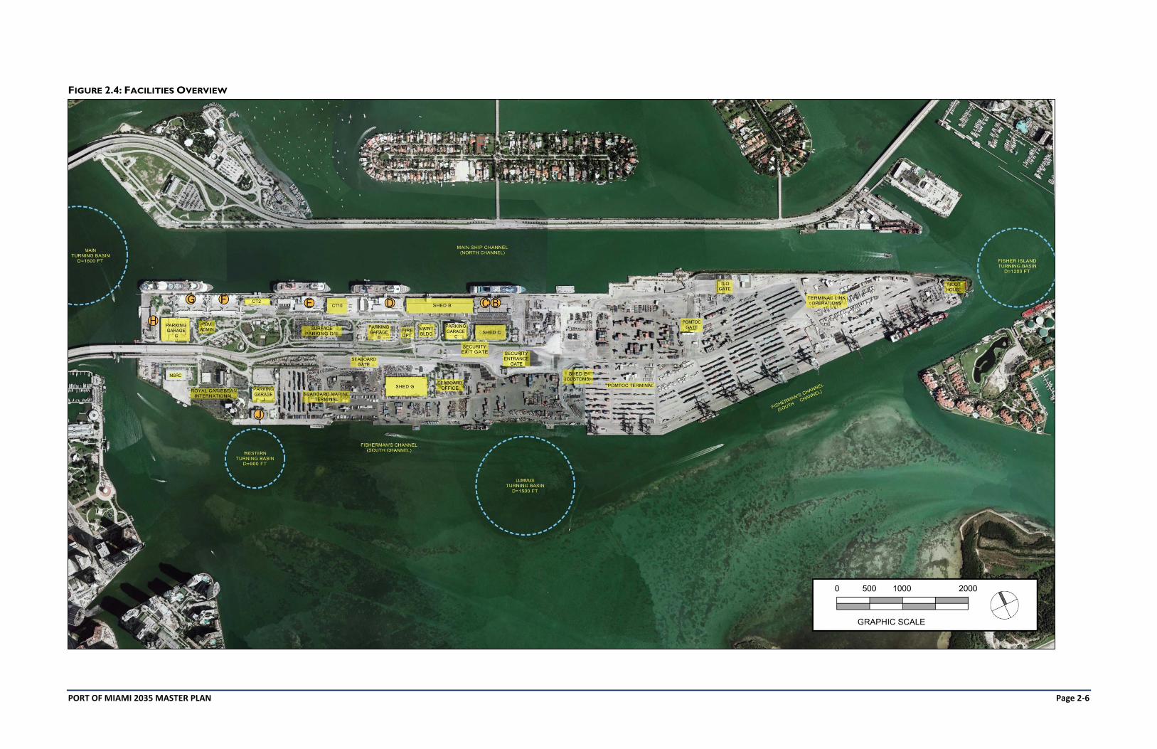
2.4 FACILITIES
Figure 2.4 shows the overall layout of the Port of Miami and defines several of the key areas, structures, and basins that
make up the operations of the facility. Since the inception of the Port, there has been continual change to develop and
enhance the Port to meet new business needs, growth, changes in the industry, functional and security requirements, and
meet the demands of the Users of the Port. In the past few years, transit sheds A and D have been demolished. Shed B is
being used mainly for cruise line provisioning for terminal B-C, Shed C is scheduled to be demolished and is currently
providing some break-bulk storage area, and Shed G - Cold storage has been partially demolished.
Additionally, the Port of Miami is currently moving forward with the renovations and improvements to Cruise Terminals D
& E and F & G, while also contemplating new projects to support future growth and support its customer base.
Future Port Capital Improvement Projects such as the tunnel, rail improvements, channel deepening, parking structures,
terminals, gate enhancements, etc. as well as the Seaboard Cargo Yard Master Plan will further develop the Port in the
short to mid-term to meet the needs of the users and provide the platform for growth of local commerce.
PORT OF MIAMI 2035 MASTER PLAN Page 2-6
FIGURE 2.4: FACILITIES OVERVIEW
PORT OF MIAMI 2035 MASTER PLAN Page 2-7
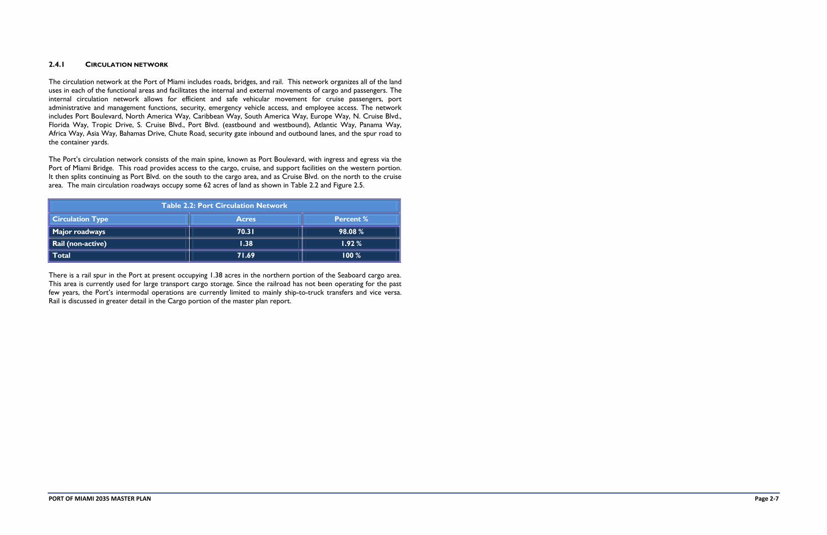
2.4.1 CIRCULATION NETWORK
The circulation network at the Port of Miami includes roads, bridges, and rail. This network organizes all of the land
uses in each of the functional areas and facilitates the internal and external movements of cargo and passengers. The
internal circulation network allows for efficient and safe vehicular movement for cruise passengers, port
administrative and management functions, security, emergency vehicle access, and employee access. The network
includes Port Boulevard, North America Way, Caribbean Way, South America Way, Europe Way, N. Cruise Blvd.,
Florida Way, Tropic Drive, S. Cruise Blvd., Port Blvd. (eastbound and westbound), Atlantic Way, Panama Way,
Africa Way, Asia Way, Bahamas Drive, Chute Road, security gate inbound and outbound lanes, and the spur road to
the container yards.
The Port’s circulation network consists of the main spine, known as Port Boulevard, with ingress and egress via the
Port of Miami Bridge. This road provides access to the cargo, cruise, and support facilities on the western portion.
It then splits continuing as Port Blvd. on the south to the cargo area, and as Cruise Blvd. on the north to the cruise
area. The main circulation roadways occupy some 62 acres of land as shown in Table 2.2 and Figure 2.5.
Table 2.2: Port Circulation Network
Circulation Type Acres Percent %
Major roadways 70.31 98.08 %
Rail (non-active) 1.38 1.92 %
Total 71.69 100 %
There is a rail spur in the Port at present occupying 1.38 acres in the northern portion of the Seaboard cargo area.
This area is currently used for large transport cargo storage. Since the railroad has not been operating for the past
few years, the Port’s intermodal operations are currently limited to mainly ship-to-truck transfers and vice versa.
Rail is discussed in greater detail in the Cargo portion of the master plan report.
PORT OF MIAMI 2035 MASTER PLAN Page 2-8
FIGURE 2.5: ROADWAY CIRCULATION NETWORK
PORT OF MIAMI 2035 MASTER PLAN Page 2-9
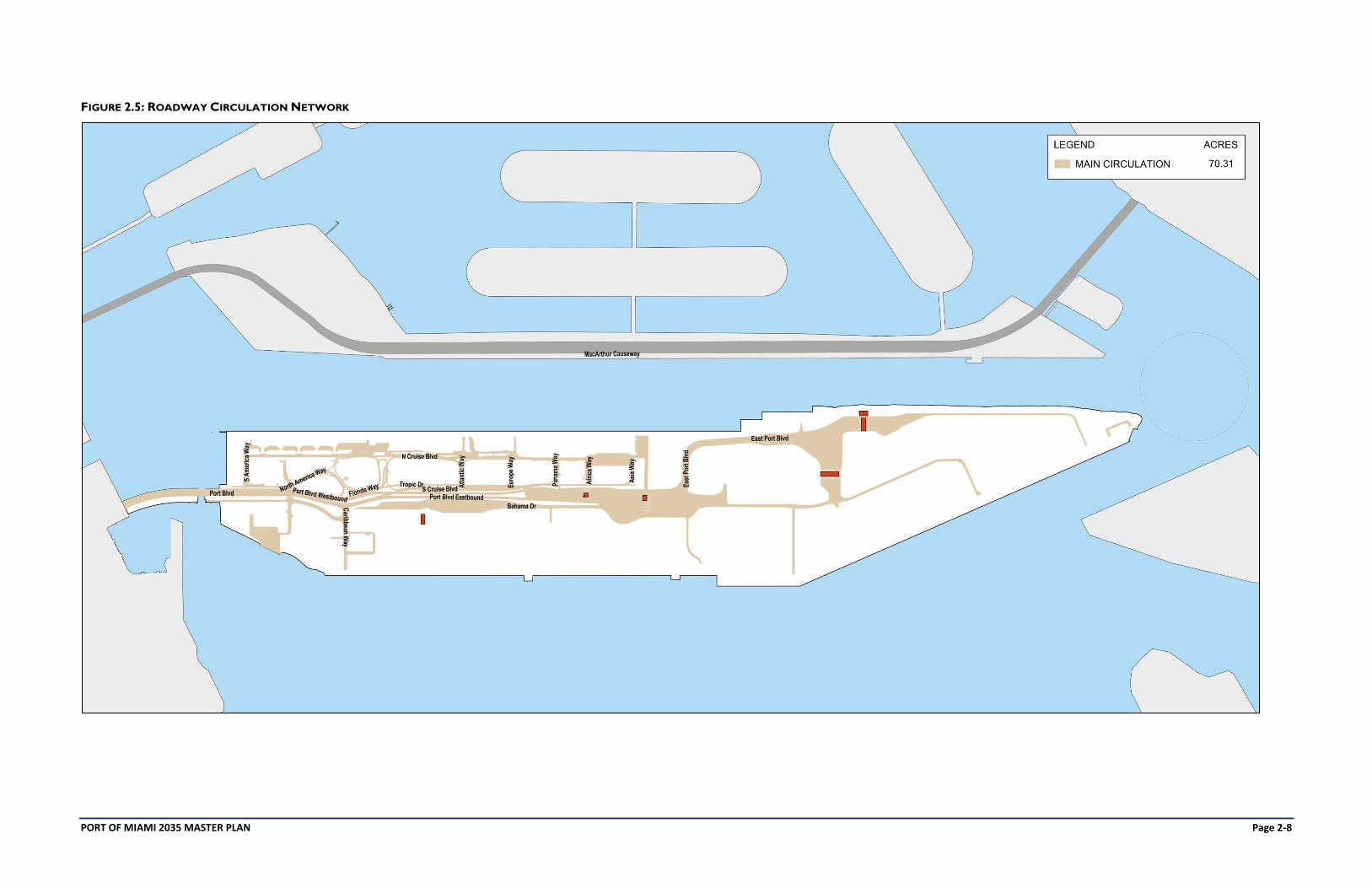
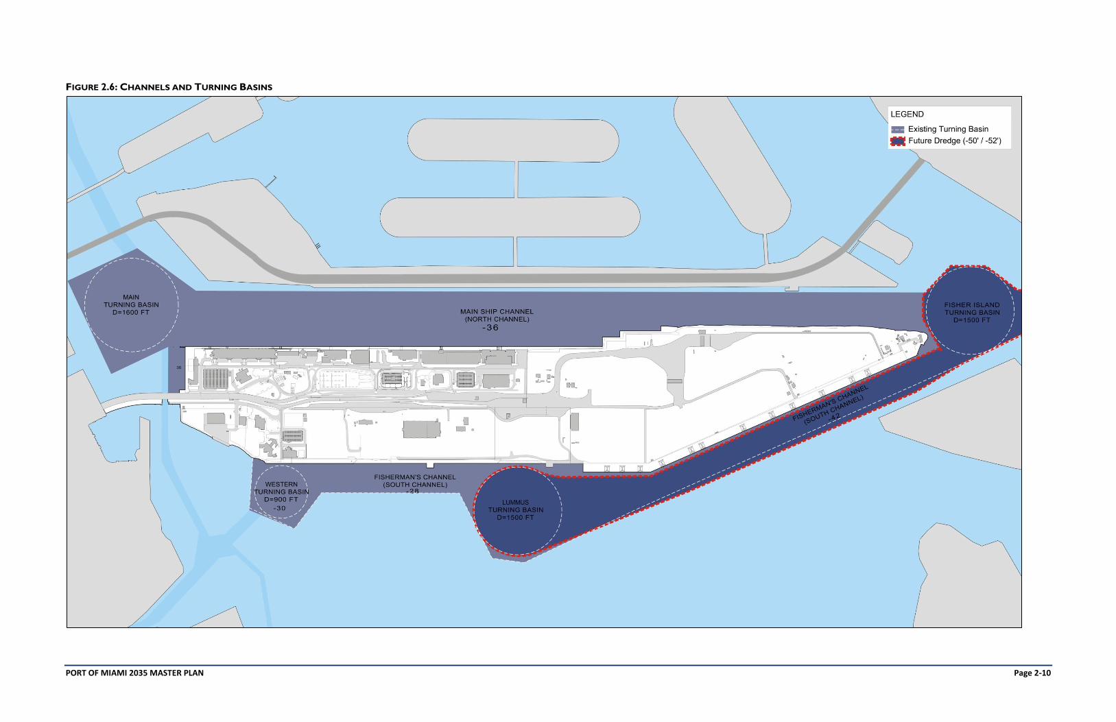
2.4.2 CHANNELS AND TURNING BASINS
The Port's principal shipping channels and turning basins are shown in Figure 2.6 and Table 2.3. These waterways
provide access to berthing areas at the Port as well as to the Miami River cargo operations and the lntracoastal
Waterway. Ships approaching from the Atlantic Ocean enter the Port of Miami through Outer Bar Cut and travel
northwest through Bar Cut to Government Cut and its 1,200-foot radius Fisher Island turning basin. Ships can
continue along the northern side of the Port along Main Ship Channel which terminates in the 1,600-foot Main
turning basin. Alternatively, ships can proceed west at the Fisher Island Turning Basin and along the Port's South
Channel which terminates in the 900-foot diameter Western Turning Basin. The South Channel also has a 1,500-
foot diameter Lummus Turning Basin at the juncture of Dodge and Lummus Islands.
A number of smaller channels in the Port vicinity feed vessels into Port channels. These include the Intracoastal
Waterway and the Miami River Channel. The depths of these channels vary from 10 to 20 feet. The only open
Anchorage at the Port of Miami lies in the Atlantic Ocean about 1.5 nautical miles outside the Outer Bar Cut.
The Port is scheduled to undergo future deepening from its existing -42-foot depth to between -50 and -52 feet in order to
accommodate the next generation of new post-Panamax cargo vessels capable of transiting the Panama Canal once that
expansion project is completed in 2014. During the dredge, other improvements to the channels will be made including
widening the Fisher Island turning basin to 1,500-feet in diameter. Sea grass and artificial reef mitigation is explained further
in Section 7.3.
This is reflected in Figure 2.6 as an on-going Port project.
PORT OF MIAMI 2035 MASTER PLAN Page 2-10
FIGURE 2.6: CHANNELS AND TURNING BASINS
PORT OF MIAMI 2035 MASTER PLAN Page 2-11
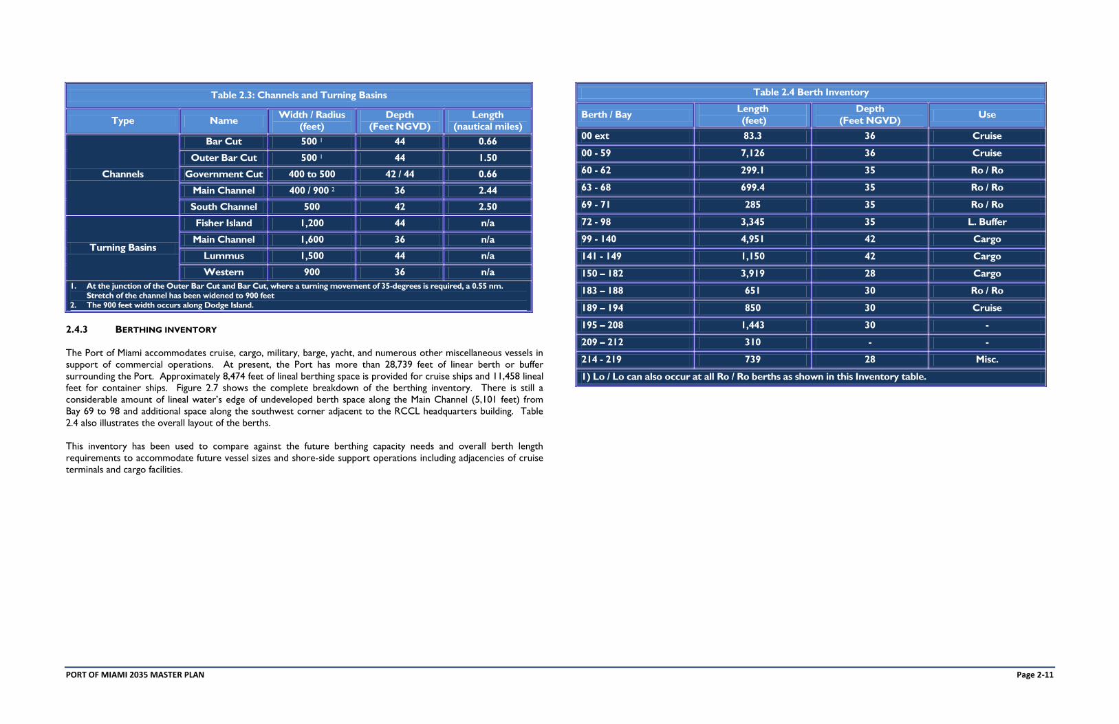
Table 2.3: Channels and Turning Basins
Type Name Width / Radius
(feet)
Depth
(Feet NGVD)
Length
(nautical miles)
Channels
Bar Cut 500 1 44 0.66
Outer Bar Cut 500 1 44 1.50
Government Cut 400 to 500 42 / 44 0.66
Main Channel 400 / 900 2 36 2.44
South Channel 500 42 2.50
Turning Basins
Fisher Island 1,200 44 n/a
Main Channel 1,600 36 n/a
Lummus 1,500 44 n/a
Western 900 36 n/a
1. At the junction of the Outer Bar Cut and Bar Cut, where a turning movement of 35-degrees is required, a 0.55 nm.
Stretch of the channel has been widened to 900 feet
2. The 900 feet width occurs along Dodge Island.
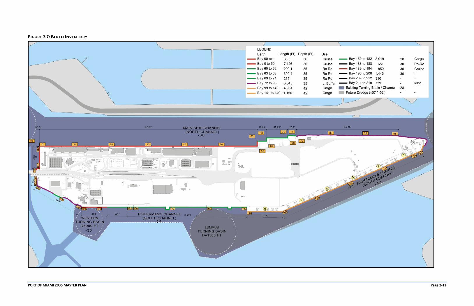
2.4.3 BERTHING INVENTORY
The Port of Miami accommodates cruise, cargo, military, barge, yacht, and numerous other miscellaneous vessels in
support of commercial operations. At present, the Port has more than 28,739 feet of linear berth or buffer
surrounding the Port. Approximately 8,474 feet of lineal berthing space is provided for cruise ships and 11,458 lineal
feet for container ships. Figure 2.7 shows the complete breakdown of the berthing inventory. There is still a
considerable amount of lineal water’s edge of undeveloped berth space along the Main Channel (5,101 feet) from
Bay 69 to 98 and additional space along the southwest corner adjacent to the RCCL headquarters building. Table
2.4 also illustrates the overall layout of the berths.
This inventory has been used to compare against the future berthing capacity needs and overall berth length
requirements to accommodate future vessel sizes and shore-side support operations including adjacencies of cruise
terminals and cargo facilities.
Table 2.4 Berth Inventory
Berth / Bay Length
(feet)
Depth
(Feet NGVD) Use
00 ext 83.3 36 Cruise
00 - 59 7,126 36 Cruise
60 - 62 299.1 35 Ro / Ro
63 - 68 699.4 35 Ro / Ro
69 - 71 285 35 Ro / Ro
72 - 98 3,345 35 L. Buffer
99 - 140 4,951 42 Cargo
141 - 149 1,150 42 Cargo
150 – 182 3,919 28 Cargo
183 – 188 651 30 Ro / Ro
189 – 194 850 30 Cruise
195 – 208 1,443 30 -
209 – 212 310 - -
214 - 219 739 28 Misc.
1) Lo / Lo can also occur at all Ro / Ro berths as shown in this Inventory table.
PORT OF MIAMI 2035 MASTER PLAN Page 2-12
FIGURE 2.7: BERTH INVENTORY
PORT OF MIAMI 2035 MASTER PLAN Page 2-13
2.5 CARGO
The Port of Miami is a general cargo port with strict limitations on handling certain types of bulk products. Principal cargos
passing through the port include fruits and vegetables, apparel and textiles, non-refrigerated food products / groceries,
paper, electronic equipment, stone, clay and cement tiles, construction and industrial equipment, trucks, buses, and
automobiles.
Four types of cargo operations occur at the Port:
Roll-on / roll-off (Ro / Ro) container operations;
Lift-on / lift-off (Lo / Lo) container operations;
Mixed-use bulk cargo operations; and,
Vehicle exports.
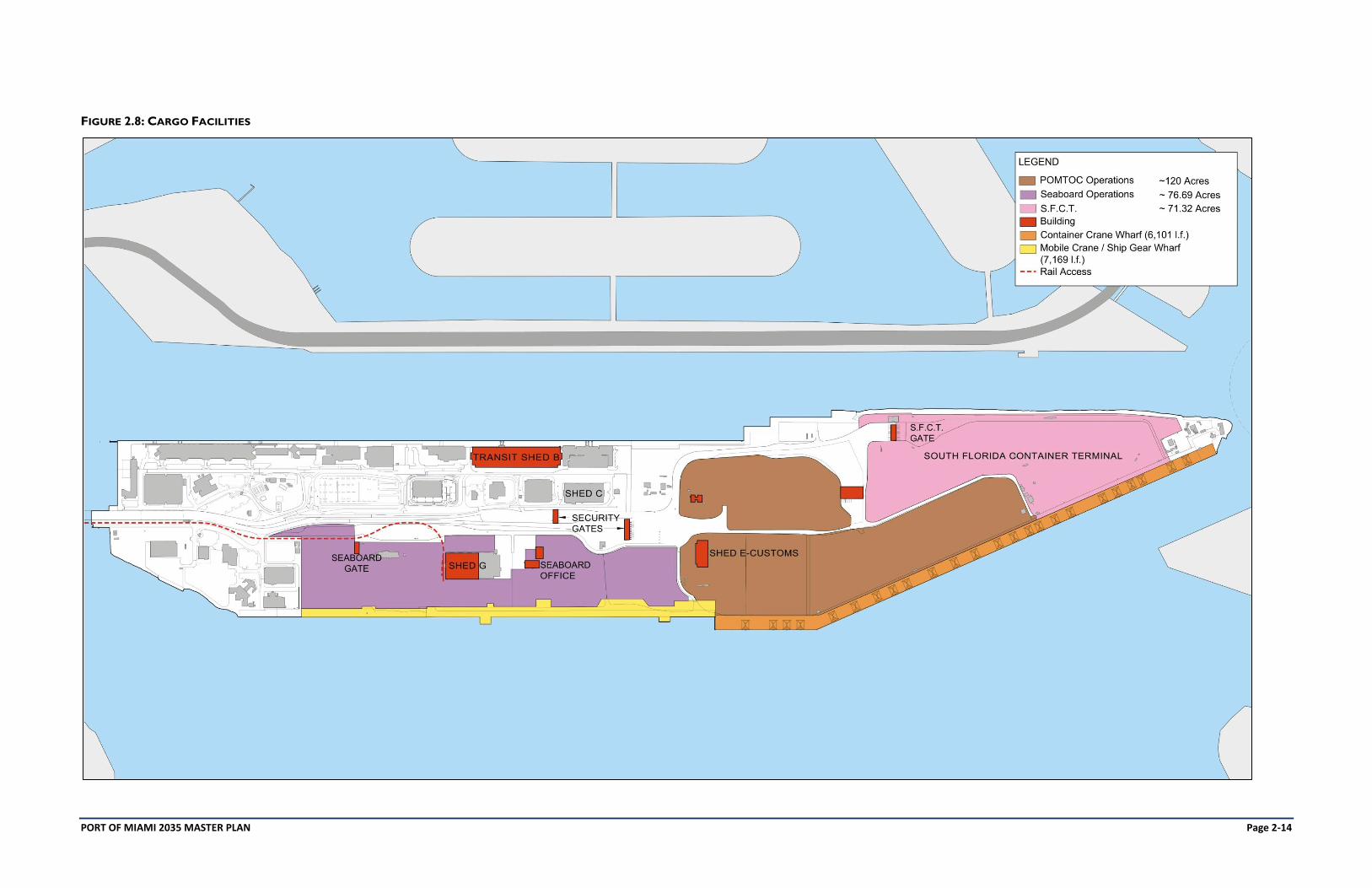
The Port allows container lines and/or stevedores to operate at the port. At present there are three major terminal
operators at the Port:
SEABOARD MARINE - is an ocean transportation company that provides direct, regular service between the
United States and the Caribbean Basin, Central America, and South America. Established in 1983, Seaboard
Marine is a wholly-owned subsidiary of Seaboard Corporation. Seaboard now serves nearly forty ports in over
twenty five countries. Seaboard Marine’s facilities include a private terminal of 76.69 acres and it is currently
redeveloping its cargo yard facilities under a long-term lease for a specified amount of land. This is a non-3rd Party
operator.
SOUTH FLORIDA CONTAINER TERMINAL (SFCT) is a joint venture terminal operator and stevedoring
company between Terminal Link (CMA CGM) and APM Terminals. This unit operates on 71.32 acres. The facility
has been operating in the Port of Miami for over 20 years; it is formerly known as APM. This is an open 3rd Party
operator.
PORT OF MIAMI TERMINAL OPERATING COMPANY (POMTOC) has been operating at the Port for more
than 10 years on 120 acres. POMTOC serves over 30 ocean carriers and handles over 200,000 TEU’s annually.
This is an open 3rd Party operator.
The Port is continuing to implement elements of the 2020 Cargo Master Plan through its Capital Improvements Program.
This includes the continued expansion of berths and upland areas to assist in improving functionality and efficiencies of the
operators. The cargo operations are also supported by a series of gate structures for inbound and outbound traffic to
track containers and conduct safety inspections on trucks (typical yard operation), and provide security through the Port
and Customs authorities (typical port operation). Each yard has an independent gate complex as well as those provided for
by the Port in the main circulation network. Currently the Port, in conjunction with the container operators, is assessing
the potential for some consolidation of efforts to further enhance the Port throughput capacity.
The main cargo projects to date include dredging deeper in order to meet the future new post-Panamax cargo vessels that
can easily reach the Port following the expansion of the Panama Canal, new Tunnel providing for increased ingress and
egress capacity for cargo with direct access to the main highway system, rail, cargo gate expansion with new inbound and
outbound lanes, software modernization to increase throughput efficiencies, and a possible consolidation of gate functions
to expedite processing times, replacing rip-rap with new bulkheads to accommodate additional vessels for cargo
operations, stronger storm protection, and cargo yard improvements to increase overall efficiencies.
The fumigation yard, which has a mandated safety ring prohibiting uses in close proximity, and the Customs and Border
Patrol facilities will be relocated in the short to mid-term from their present locations.
Table 2.5 and Figure 2.8 identify the current cargo operational areas and support facilities.
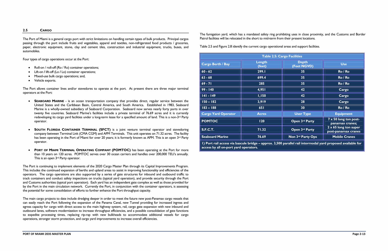
Table 2.5: Cargo Facilities
Cargo Berth / Bay Length
(feet)
Depth
(Feet NGVD) Use
60 - 62 299.1 35 Ro / Ro
63 - 68 699.4 35 Ro / Ro
69 - 71 285 35 Ro / Ro
99 - 140 4,951 42 Cargo
141 - 149 1,150 42 Cargo
150 – 182 3,919 28 Cargo
183 – 188 651 30 Ro / Ro
Cargo Yard Operator Acres User Type Equipment
POMTOC 120 Open 3rd Party 7 x 50 long ton post-
panamax cranes;
2 x 65 long ton super
post-panamax cranes S.F.C.T. 71.32 Open 3rd Party
Seaboard Marine 76.69 Non 3rd Party Ops Mobile Cranes
1) Port rail access via bascule bridge – approx. 3,500 parallel rail intermodal yard proposed available for
access by all on-port yard operators.
PORT OF MIAMI 2035 MASTER PLAN Page 2-14
FIGURE 2.8: CARGO FACILITIES
PORT OF MIAMI 2035 MASTER PLAN Page 2-15
2.6 CRUISE
The Port of Miami serves as a primary port of embarkation / debarkation (home port) for the Caribbean region and is
mostly used by the top three cruise lines in the world - Carnival Corporation (principal Miami brand – Carnival Cruise
Line), Royal Caribbean Cruise Lines (Royal Caribbean International, Celebrity Cruises and Azamara Club Cruises) and
Norwegian Cruise Line. Cruise operations occur on the north side of the island.
Cruise facilities located in this area includes six cruise terminals with 724,684 square feet of interior operational space,
cruise berths, cruise ship loading and support aprons, customs inspection and storage areas, provisioning spaces, and
parking areas (see Figure 2.9). Additionally, Terminal J is located on the Southwest side of the Port and is able to
accommodate cruise vessels up to 800 feet in length based upon current pilot standards. The landside portion of cruise
terminal operations, including parking, comprises approximately 52 acres. Table 2.6 illustrates the characteristics and sizes
of the present cruise terminals at the Port.
Table 2.6: Cruise Terminals
Terminal Interior Facility Size
(square feet) Primary Tenant
Passenger
Capacity
Year Built /
Refurbished
B 91,782 NCL 5,000 1980 / 2010
C 91,782 NCL 5,000 1980 / 2010
D 115,000 CCL 4,000 + 2007
E 115,000 CCL 4,000 + 2007
F 127,500 RCCL 4,000 + 1999
G 127,500 RCCL 4,000 + 1999
J 56,120 SMALL SHIP 1,500 1988
Since their inception in the early 1970’s all of the Port’s cruise terminals have been remodeled or redeveloped to
accommodate increasing passenger ship capacities and user demand. Government inspection functions have also been
added. All of the cruise terminal facilities have modern gangway systems to meet the cruise vessel shell door requirements.
The following are major upgrades or changes implemented to the terminals:
TERMINALS B AND C - refurbished in 2010 utilizing green performance standards for the use by NCL for their
new large ship “Epic”.
TERMINALS F AND G – Built in 1999 these are allocated to RCCL. The Port of Miami plans to renovate these
facilities to meet long-term cruise needs.
TERMINALS D & E – Built in 2007, they are allocated to Carnival Corporation. These facilities are currently being
renovated to meet future vessel capacity and passenger demands for completion in 2012.
TERMINAL J is used by luxury brand cruise lines with smaller ships.
The continued growth in the size of vessels affects the Port's ability to handle the mega-vessel passenger throughput. As
discussed, and as shown as a major part of this 2035 Master Plan, some of these facilities will require renovations in the
future to accommodate this increased demand.
One of the major issues for the Port of Miami at present and over the long-term is the ability to accommodate larger
cruise vessels of 1,200 feet in length with larger passenger capacities. The current layout of the terminals does not provide
for flexibility to accomplish this. This element is further discussed in the sections that follow.
PORT OF MIAMI 2035 MASTER PLAN Page 2-16
FIGURE 2.9: CRUISE FACILITIES
PORT OF MIAMI 2035 MASTER PLAN Page 2-17
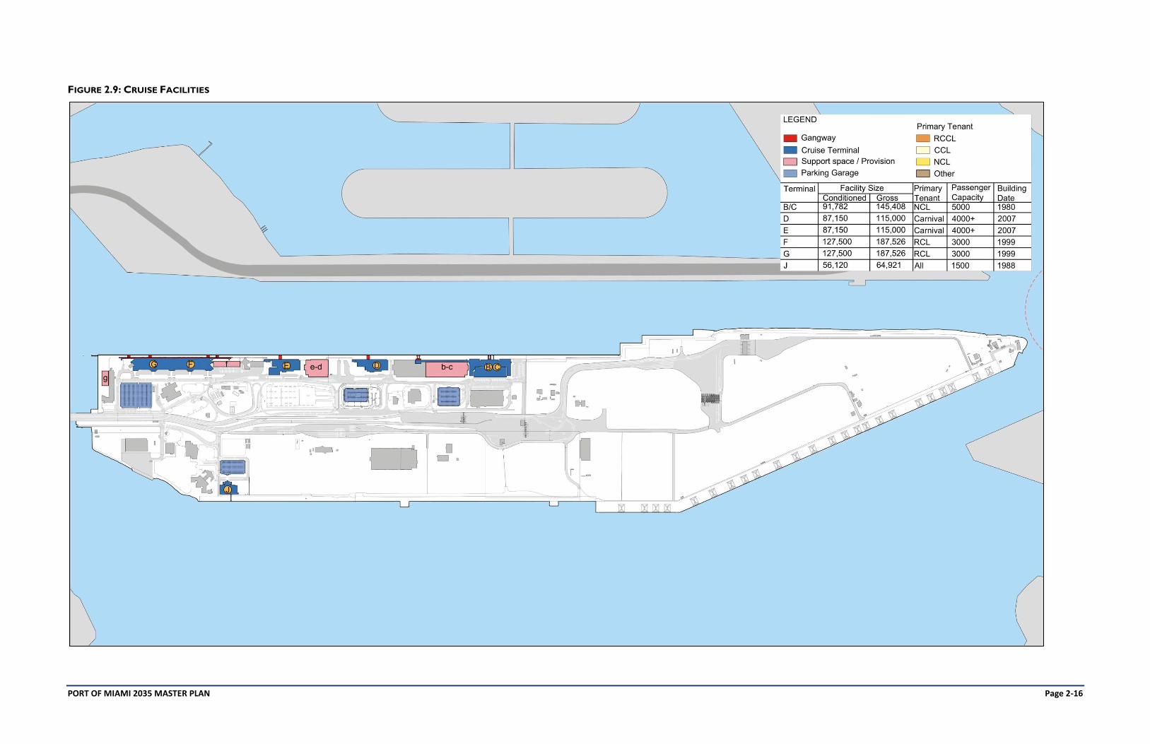
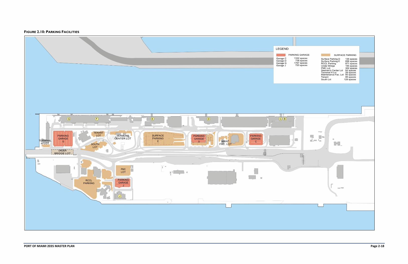
2.7 PARKING FACILITIES
Parking at the Port of Miami for cruise ship passengers, visitors, and employees is provided in surface lots and structured
parking facilities throughout the Port. With the addition of Garage D in 2010 (864 spaces), the Port provides a total of
4,557 structured parking spaces and 791 surface spaces for cruise operations, 871 spaces for RCCL office parking and
another 882 spaces for tenant, government, and visitor parking. These smaller lots associated with security, CBP, Port of
Miami services, and others for operational concerns of the Port are located adjacent to the Miami World Trade Center
and other key areas throughout the Port. The inventory of the parking facilities is shown in Table 2.7.
Table 2.7: Parking Inventory
Type Garage Facility Capacity (spaces) Uses
Structured
Garage
Parking
C 1,332 Cruise
D 738 Cruise
G 1,709 / 58 Cruise / Govt.
J 720 Cruise
Surface Lots
D 135 Cruise
E 656 Cruise
PMC 302 Seaboard / Visitor
RCCL 871 RCCL
Under Bridge / Office 195 POM / CBP / Visitor
Tenant 85 POM Tenants
Seamen’s Center 64 Visitor
South Lot 128 Visitor
Maintenance Bldg. 80 POM / Visitor
Terminal H 28 POM / CBP
Generally, cruise passenger parking lots are located across from the cruise passenger terminals along Cruise Blvd.
However, since cruise volumes are not balanced among cruise terminals, the passenger parking demand and availability is
misaligned. Since the parking structures are individual and not connected, this creates operational issues between
passengers walking to and from their vehicles. The inventory of the port parking facilities is shown in Figure 2.10.
PORT OF MIAMI 2035 MASTER PLAN Page 2-18
FIGURE 2.10: PARKING FACILITIES
PORT OF MIAMI 2035 MASTER PLAN Page 2-19
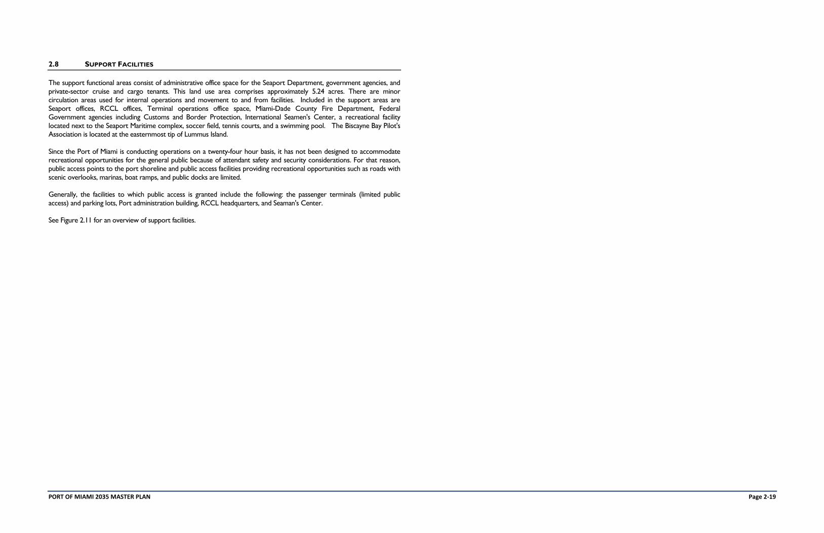
2.8 SUPPORT FACILITIES
The support functional areas consist of administrative office space for the Seaport Department, government agencies, and
private-sector cruise and cargo tenants. This land use area comprises approximately 5.24 acres. There are minor
circulation areas used for internal operations and movement to and from facilities. Included in the support areas are
Seaport offices, RCCL offices, Terminal operations office space, Miami-Dade County Fire Department, Federal
Government agencies including Customs and Border Protection, International Seamen's Center, a recreational facility
located next to the Seaport Maritime complex, soccer field, tennis courts, and a swimming pool. The Biscayne Bay Pilot's
Association is located at the easternmost tip of Lummus Island.
Since the Port of Miami is conducting operations on a twenty-four hour basis, it has not been designed to accommodate
recreational opportunities for the general public because of attendant safety and security considerations. For that reason,
public access points to the port shoreline and public access facilities providing recreational opportunities such as roads with
scenic overlooks, marinas, boat ramps, and public docks are limited.
Generally, the facilities to which public access is granted include the following: the passenger terminals (limited public
access) and parking lots, Port administration building, RCCL headquarters, and Seaman's Center.
See Figure 2.11 for an overview of support facilities.
PORT OF MIAMI 2035 MASTER PLAN Page 2-20
FIGURE 2.11: SUPPORT FACILITIES
PORT OF MIAMI 2035 MASTER PLAN Page 2-21
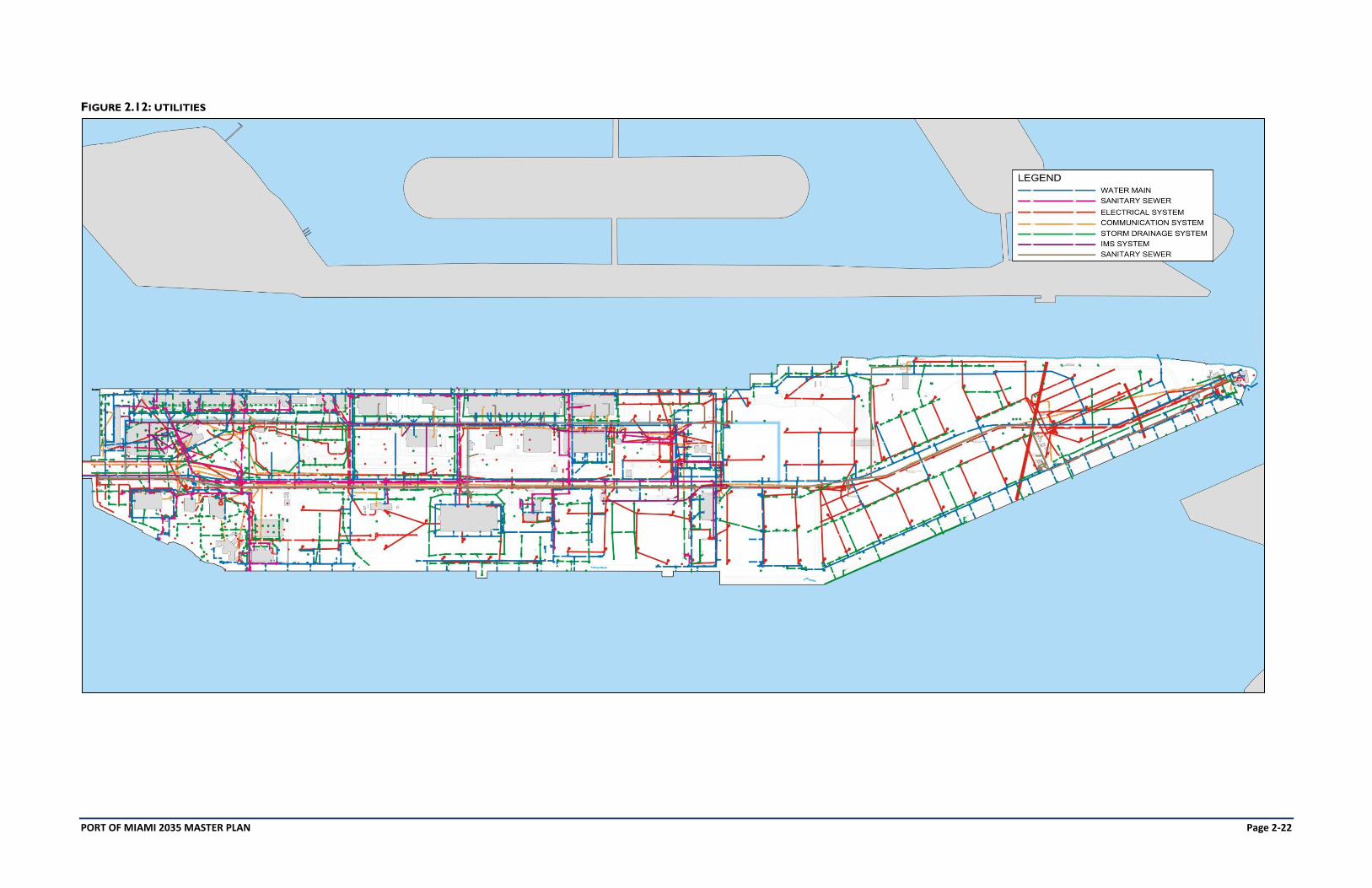
2.9 UTILITIES – WATER, SANITARY SEWER, ELECTRIC, COMMUNICATION, STORM DRAINAGE, IMS
Existing utility infrastructure facilities at the Port of Miami include potable water, sanitary sewer, electric, and
telecommunication and drainage systems. Each of these systems presently has adequate capacity to accommodate the
present demands. Future needs for these infrastructure facilities related to the recommended plan for port expansion
through the year 2035 are evaluated in Section 7.
The Seaport Department owns and operates the water distribution system on the Port. The 20-inch water transmission
main connection to downtown is owned by WASD and is part of a loop system to Fisher Island and Virginia Key. This 20-
inch water transmission main extends from downtown to both Dodge and Lummus Islands and links with existing 20-inch
mains on Fisher Island and Virginia Key. This loop allows the Port and those adjacent users to be served from both
directions, thereby eliminating the vulnerability of a single direction supply main. A network of pipelines with sizes ranging
from one to twenty inches in diameter, off of the 20-inch water main, provide domestic and fire protection service to the
Port. The primary users of potable water at the Port of Miami are cruise ships, cargo ships, and support facilities.
Cruise and cargo ships which use the vast majority of potable water are supplied via hose connections at all berths.
Potable water is sold to cruise and cargo ships.
The Seaport Department owns and operates the wastewater collection system, transmission mains, and the on-port pump
stations. The existing sanitary sewage system includes 6 pump stations and a wastewater collection system consisting of
eight and ten inch gravity lines and properly spaced manholes.
The Port’s main pump station is a dry-well/wet-well type with two pumps, each rated at a capacity of 720,000 gallons per
day (GPD). This pump station, located approximately southeast of the intersection of Port Boulevard and Europe Way,
pumps into the WASD collection system through an existing eight inch force main running along Port Boulevard.
Wastewater generated at the Port is collected and routed to the WASD system for treatment at its Central District
Wastewater Treatment Plant on Virginia Key. The rated capacity of the plant can accommodate the present wastewater
flows generated by the Port. Wastewater flows are generated almost entirely from the offices and terminals at the Port of
Miami. Currently, cruise and cargo ships do not discharge their wastewater into the Port’s collection system.
The existing drainage system at the Port of Miami has been developed in tandem with the evolution of the Port from its
initial construction on Dodge Island in 1960 to its expansion to Lummus Island after 1979. The system was designed to
conform to standards in place at the time of physical development.
The drainage system at the Port of Miami consists of an interconnected series of drainage wells, surface ponding storage,
retention basins, and pollution-retardant basins with several emergency overflow discharge connections to Biscayne Bay.
Where possible, surface water runoff is routed either through grass swales or overland flow into catch basins that are
interconnected into a series of drainage wells.
All new drainage systems are being designed to handle a 25-year, 24-hour duration storm in compliance with the Miami-
Dade County Public Works Department policies. Additional runoff storage is being provided on the ground surface.
Grassed swales with retention basins are being incorporated where open space is available, such as the southwest complex
on Dodge Island. Upgrade of these systems is ongoing.
The drainage system is designed to retain at least the first inch of runoff within the well system prior to emergency
overflow to Biscayne Bay. Pollution-retardant basins act to retain greases, oils, and other pollutants within the system,
thereby diminishing the potential degradation of the water quality within Biscayne Bay.
The operation and maintenance of the surface water drainage system is the responsibility of the Miami-Dade County
Seaport Department.
Florida Power and Light (FPL) is the primary power provider for Port of Miami operations. The power is provided from
two 13.2-kilovolt feeders on Dodge Island. There is also an on-port substation on the eastern portion of Lummus Island
and a cogeneration facility providing electricity and chilled water for the Port.
All existing communications facilities are provided by AT&T which expands its service to meet Port needs. A state-of-the-
art fiber optic ring (IMS) runs throughout the Port to provide for enhanced communications.
See Figure 2.12 for an overview of all Port of Miami utilities.
PORT OF MIAMI 2035 MASTER PLAN Page 2-22
FIGURE 2.12: UTILITIES