Embed Size (px)
Citation preview

37 Empire Road, Parktown, 2193 P.O. Box 291803, Melville, 2109
Tel : (011) 482-4131 Fax : (011) 482-9959
E-Mail : [email protected]
URBAN DYNAMICS
T O W N P L A N N I N G R E P O R T
PORTION 133 GEDULD 123 IR, SPRINGS
PROPOSED MIXED INDUSTRIAL DEVELOPMENT: FUEL CELLS PLANT
EKURHULENI METROPOLITAN MUNICIPALITY

TABLE OF CONTENT
1. INTRODUCTION AND BACKGROUND ............................................................................ 1
2. PROPERTY PARTICULARS .............................................................................................. 2
2.1 PROPERTY DESCRIPTION, OWNERSHIP AND SIZE ................................................................... 2 2.2 LOCALITY ................................................................................................................................ 2 2.3 TITLE CONDITIONS & SERVITUDES ......................................................................................... 4 2.4 EXISTING ZONING ................................................................................................................... 4 2.5 EXISTING LAND USE ................................................................................................................ 5 2.6 SURROUNDING ZONING ........................................................................................................... 6 2.7 SURROUNDING LAND USE ....................................................................................................... 7
3. DEVELOPMENT PROPOSAL ........................................................................................... 7
3.1 LAYOUT PLAN ......................................................................................................................... 8 3.2 TOWN PLANNING ISSUES ...................................................................................................... 10 3.3 TOWN PLANNING PROCEDURE FOR TOWNSHIP ESTABLISHMENT TO BE LODGED AT A LATER
PHASE OF THE PROPOSED DEVELOPMENT ....................................................................................... 11
4. NEED AND DESIRABILITY ............................................................................................. 13
3.1 NEED ..................................................................................................................................... 14 3.2 DESIRABILITY ........................................................................................................................ 14 3.3 MOTIVATION IN TERMS OF THE DEVELOPMENT PRINCIPLES OF THE SPATIAL PLANNING AND
LAND USE MANAGEMENT (SLPUMA) ACT NO 16 OF 2013 ........................................................... 17 3.3.1 IMPLICATIONS OF THE ACT ON THE PROPOSED DEVELOPMENT............................................ 17
5. CONCLUSION ................................................................................................................. 19
LIST OF ANNEXURES

Annexure A : Locality Plan Annexure B : Title Deed Annexure C : Zoning Plan LIST OF FIGURES p Figure 1: Regional Location of Portion 133 Geduld 123 IR .......................................................... 1 Figure 2: Aerial view of site .............................................................................................................. 3 Figure 3: Regional Context of site.................................................................................................... 4 Figure 4: Proposed Layout of Portionc133 Geduld 123 IR ........................................................... 8 Figure 5: Sasol Gas Pipeline Network ........................................................................................... 10 Figure 6: Map showing dolomitic area of site .............................................................................. 11 Figure 7: Industrial and Business footprint of Region D ............................................................ 15 Figure 8: Extract from RSDF 2015 ................................................................................................. 16 LIST OF TABLES
p Table 1: Property Descriptions, Ownership and Size .................................................................... 2 Table 2: Existing Zoning of Portion 133 Geduld 123 IR ................................................................ 4 Table 3: Surrounding Zonings .......................................................................................................... 6 Table 4: Timeframe for Township Establishment ....................................................................... 13
March 2018
Portion 133 Geduld 123 IR: Town Planning Report Page 1
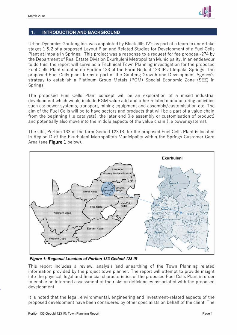
1. INTRODUCTION AND BACKGROUND Urban Dynamics Gauteng Inc. was appointed by Black Jills JV’s as part of a team to undertake stages 1 & 2 of a proposed Layout Plan and Related Studies for Development of a Fuel Cells Plant at Impala in Springs. This project was a response to a request for fee proposal-274 by the Department of Real Estate Division Ekurhuleni Metropolitan Municipality. In an endeavour to do this, the report will serve as a Technical Town Planning investigation for the proposed Fuel Cells Plant situated on Portion 133 of the Farm Geduld 123 IR at Impala, Springs. The proposed Fuel Cells plant forms a part of the Gauteng Growth and Development Agency’s strategy to establish a Platinum Group Metals (PGM) Special Economic Zone (SEZ) in Springs. The proposed Fuel Cells Plant concept will be an exploration of a mixed industrial development which would include PGM value add and other related manufacturing activities such as: power systems, transport, mining equipment and assembly/customisation etc. The aim of the Fuel Cells will be to have sectors and products that will be a part of a value chain from the beginning (i.e catalysts), the later end (i.e assembly or customisation of product) and potentially also move into the middle aspects of the value chain (i.e power systems). The site, Portion 133 of the farm Geduld 123 IR, for the proposed Fuel Cells Plant is located in Region D of the Ekurhuleni Metropolitan Municipality within the Springs Customer Care Area (see Figure 1 below).
This report includes a review, analysis and unearthing of the Town Planning related information provided by the project town planner. The report will attempt to provide insight into the physical, legal and financial characteristics of the proposed Fuel Cells Plant in order to enable an informed assessment of the risks or deficiencies associated with the proposed development. It is noted that the legal, environmental, engineering and investment-related aspects of the proposed development have been considered by other specialists on behalf of the client. The
Ekurhuleni
Figure 1: Regional Location of Portion 133 Geduld 123 IR

March 2018
Portion 133 Geduld 123 IR: Town Planning Report Page 2
technical aspects should be considered in the context of this bigger picture and may require further inter-advisory liaison.
2. PROPERTY PARTICULARS This section of the memorandum contains all the relevant information with regards to the property and its surrounds. Reference will be made to documents such as the Title Deed and the Zoning Plan in the annexures to this report. The objective of this section is to provide a summary and overview of the supplied and gathered information and therefore assimilate the information for ease of reference and to create a better understanding of the site. It is anticipated that this will feed into a wider Due Diligence for project funding, marketing and implementation. This section is divided into the following sub-sections relating to the following: - Locality; - Existing and Surrounding Land Uses; - Existing and Surrounding Zoning; and - Legal Issues Portion 133 of the farm Geduld 123 IR, represents land which is currently partially developed and partially vacant and zoned “Industrial 1” in terms of the Ekurhuleni Town Planning Scheme, 2014. Town Planning Status: The land is currently zoned Use Zone 8: “Industrial 1”. The purposes for which the land may be used include; Industries, Offices, Commercial Purposes, Showrooms, Motor Dealers, Panel Beaters, Builder’s Yards, Service Industries, Fitment centres, Motor Workshops, Light Industries and Auctioneers. The Zoning Plan is attached hereto as Annexure C. Development Status: Portion 133 of the farm Geduld 123 IR has a formal development status on the southern part of the portion. The site is partially developed with mining offices, a football pitch, golf driving range and treatment pond. The northern part of the portion is vacant and undeveloped. Legal Status: The land is registered vide the Transfer Title Deed 67314/1993 in favour of Impala Platinum Limited. All restrictive title conditions will be dealt with in the sections below. 2.1 PROPERTY DESCRIPTION, OWNERSHIP AND SIZE Below please find a table summarising the property descriptions, ownership and size of the subject erven: Table 1: Property Descriptions, Ownership and Size
ERF DESCRIPTION REGISTERED OWNER TITLE DEED DESCRIPTION
SIZE ha
Portion 133 Geduld 123 IR
Impala Platinum Limited
T67314/1993
29,1882ha
Attached hereto as Annexure B please find copy of the Title Deed. 2.2 LOCALITY On a regional scale, Portion 133 of the farm Geduld is located in Region D of Ekurhuleni Metropolitan Municipality.

March 2018
Portion 133 Geduld 123 IR: Town Planning Report Page 3
The property is situated directly south of a railway station. The site is situated directly west of East Geduld Road, directly north of Cowles Street and Impala Refineries. At a regional level the site is surrounded by major road networks such as the N12 which situated 16km north of the site. The N17 is situated 8km south of the site and the R29 is situated 2,5km west of the site, as seen in Figure 3. The R59 is also situated 5km south of the site. Furthermore, the site is located 10km north of the Nuffield Industrial node and 1,5km of the Enstra Industrial area. Figure 2: Aerial view of site
Site
Site
R29
N17
N12
R51

March 2018
Portion 133 Geduld 123 IR: Town Planning Report Page 4
Attached hereto as Annexure A, please find a copy of the Aerial Locality Plan for the site. 2.3 TITLE CONDITIONS & SERVITUDES Portion 133 Geduld 123 IR has restrictive title conditions, mostly related to servitudes. These conditions; a) relating to historic mining rights, b) relating to coal mining rights,c) and d) relating to an Eskom Powerline servitude and e) relating to a water pipeline servitude are reflected in the Title Deed T67313/1993 and are stipulated as follows:
a) Subject to Mynpacht No. 481/1899
b) That portion being Mineral Area No.5 of the former Remaining Extent of the farm Geduld 123, Registration Division IR, Transvaal, measuring 3349,2912 hectares (whereof the property hereby transferred forms a portion) is subject to the following condition: “Het eigendom hieronder gehouden is onderworpen en gerechtigd tot de termen van zeker Notariele Akte No. 51/1927S met aangehechte dokumenten met betrekking tot koolrechten, zoals meer ten volle zal blijken uit Notariele Akte No. 51/1927S op 26 Januarie 1927”
c) The former Remaining Extent of the farm Geduld 123, Registration Division IR,
Transvaal, measuring 1994,5655 hectares (whereof the property hereby transferred forms a portion) is subject to a servitude to convey electricity in favour Eskom together with ancillary rights and subject to conditions as will more fully appear from Notarial Deed K3480/76S registered on 3 December 1976.
d) The former Remaining Extent of the farm Geduld 123, Registration Division IR, Transvaal, measuring 1965,4858 hectares (whereof the property hereby transferred forms a portion) is subject to a servitude to convey electricity in favour of Eskom together with ancillary rights and subject to conditions as will more fully appear from Notarial Deed K2874/1978S registered on 21 November 1978.
e) The former Remaining Extent of the farm Geduld 123, Registration Division IR, Transvaal, measuring 1965,8458 hectares (whereof the property hereby transferred forms a portion is subject to a servitude for water pipe lines indicated by the figure ABCDEFGHKLM on diagram S.G No. A8919/70 in favour of Sappi Limited together with ancillary rights and subject to conditions, as will more fully appear from Notarial Deed K2874/1978S registered on 21 Novmber 1978.
Furthermore, conditions; f, g,h,i,j,k,l,m,n and o, also relate to servitudes on the property. While the conditions relate to servitudes, these will not be a hindrance to the proposed mixed use industrial development and they will be incorporated in the township establishment based on the Land Surveyor certificate and conveyancer certificate. 2.4 EXISTING ZONING The property is currently zoned as follows in terms of the Ekurhuleni Town Planning Scheme, 2014: Table 2: Existing Zoning of Portion 133 Geduld 123 IR
USE ZONE “Industrial 1”
Figure 3: Regional Context of site

March 2018
Portion 133 Geduld 123 IR: Town Planning Report Page 5
PRIMARY RIGHTS Industries, Offices, Commercial Purposes, Showrooms, Motor Dealers, Panel Beaters, Builder’s Yards, Service Industries, Fitment centres, Motor Workshops, Light Industries and Auctioneers
CONSENT RIGHTS Noxious Industries, Places of Entertainment, Waste Disposal Sites, Brick Making, Filling Stations, Special Uses.
HEIGHT 2 storeys COVERAGE 70% FAR As per scheme PARKING 1 bay per first 1000m2 floor area, or part thereof and 2 bays per every
1000m2 floor area hereafter DENSITY n/a BUILDING LINE As per scheme
The zoning of the site as “Industrial 1” is beneficial because it allows a wide scope of land use rights and an opportunity for consent use of more heavier/noxious industrial activities as well as ancillary uses. The Zoning Plan for the farm portion is attached hereto as Annexure C. 2.5 EXISTING LAND USE Portion 133 of the farm Geduld is currently partially developed with Impala mining offices, a football pitch, golf driving range and treatment pond.

March 2018
Portion 133 Geduld 123 IR: Town Planning Report Page 6
Figure 3: Portion 133 Geduld 123 IR land use 2.6 SURROUNDING ZONING The surrounding zonings are indicated on the Zoning Plan which is attached as Annexure C. The properties situated north of the site are zoned “Agricultural” and “Mining Land”. The properties situated south of the site are zoned “Residential 1”, “Public Open Space” and “Private Open Space”. The property situated east of the site is zoned “Industrial 1”. The property situated west of the site is zoned “Agricultural” The site, Portion 133 Geduld 123 IR, is zoned “Industrial 1”. The zonings of the erven adjacent to the site are indicated in the table below: Table 3: Surrounding Zonings
PROPERTY USE ZONE NORTH Portion 190 Geduld 123 IR Agricultural
RE 67 Geduld 123 IR Mining Land RE 36 Geduld 123 IR Mining Land Portion 191 Geduld 123 IR Agricultural
Mining Offices
Football pitch
Golf Driving Range
Treatment pond

March 2018
Portion 133 Geduld 123 IR: Town Planning Report Page 7
EAST Portion 134 Geduld 123 IR Industrial 1 SOUTH Erf 222 East Geduld Public Open Space WEST RE 223 East Geduld Public Open Space
RE 135 Geduld 123 IR Industrial 1 2.7 SURROUNDING LAND USE The area is dominated by industrial buildings used for mining related industrial activities. The properties situated north of the site are vacant. The properties situated south of the site are used for residential houses and open spaces as well as some industrial activities. The property situated east of the site is used for platinum refinery and related activities. The property situated west of the site is vacant. The surrounding land uses area based on our interpretation of the buildings apparent use which is not always very clear or evident from viewing the structure.
3. DEVELOPMENT PROPOSAL The Ekurhuleni metro covers the largest industrial concentration in South Africa and in Sub-Saharan Africa. The economy of Ekurhuleni grow from the apartheid legacy of mineral-oriented industrialisation and the growth of an urban labour pool to supply the mines. Ekurhuleni’s growth was mainly based in the main concentration of gold mining in the country and this is reflected in the structure of manufacturing. In 1996, Ekurhuleni accounted for 37% of South African output of machinery and 33% of metal products due to the then thriving mining market. Since then the economic performance of Ekurhuleni has declined with the mining sectors and unemployment has increased rapidly. It is for this reason that the regeneration of the industrial base of Ekurhuleni is vital. Currently industry in Ekurhuleni is concentrated and mostly based on intermediate products such as machinery and metal products and consumer goods such as food products and consumer chemicals. Industry in the metro does not consist much of capital intensive upstream indudtries such as non-ferrous metals, basic chemical and basic iron and steel. As an alternative the metro rather uses basic metals and basic chemicals that are produced elsewhere in South Arica as material inputs for higher-value added and labour intensive manufacturing. Given that there is a need for the revitalisation of the industrial sector in Ekurhuleni, the Gauteng Growth and Development Agency has strategised the expansion programme for the Gauteng Industrial Development Zone (GIDZ) Implementation. The focus of the strategy is on the mineral beneficiation sector, broader light manufacturing and high value low mass manufacturing. The aim of the strategy is to enhance benefication of products for export, resulting in increased contribution of the GIDZ to Gauteng’s economy and the GDP of South Africa. The proposed mixed industrial development (Fuell Cell Plant) forms a part of the GGDA’s GIDZ strategy as it is included in the proposed PGM Value-Add SEZ in Springs. In light of the above, it is proposed to develop a Fuel Cell Plant on Portion 133 Geduld 123 IR, which forms a part of the Gauteng Growth and Development Agency’s strategy to establish a Platinum Group Metals (PGM) Special Economic Zone (SEZ) in Springs.

March 2018
Portion 133 Geduld 123 IR: Town Planning Report Page 8
3.1 LAYOUT PLAN The proposed Fuel Cells Plant concept will be an exploration of a mixed industrial development which would include PGM value add and other related manufacturing activities such as: power systems, transport, mining equipment and assembly/customisation etc. The aim of the Fuel Cells will be to have sectors and products that will be a part of a value chain from the beginning (i.e catalysts), the later end (i.e assembly or customisation of product) and potentially also move into the middle aspects of the value chain (i.e power systems). The proposed layout, which can be implemented in phases, is depicted in the figure below.
The proposed layout for the mixed use industrial development can be motivated in terms of all existing policy guidelines and legal frameworks in mind. It is motivated that the proposed development (layout) takes into consideration the following factors and principles: Locational Advantage The Ekurhuleni RSDF states that as a priority, infill residential development should be promoted in all strategically located vacant areas that are suitable for development. The subject land is ideally located and is identified for densification and industrial development on the RSDF Plan, furthermore; the subject land falls well within the demarcated urban edge for the Ekurhuleni Metropolitan Municipality. Focussed Public and Private Investment The Gauteng Spatial Development Framework (GSDF) limits development to areas located within a provincial urban edge. This development area falls within this urban edge and can be considered a strategic infill opportunity to focus public and private investment in an
Figure 4: Proposed Layout of Portionc133 Geduld 123 IR

March 2018
Portion 133 Geduld 123 IR: Town Planning Report Page 9
accountable and suitable manner. The site benefits from the fact that it is prioritised by the GGDA for PGM SEZ implementation and can therefore give private investors and incentive to invest in the project. Economic Upliftment A project like this will create positive spin-offs in terms of job creation for the construction period of the project and the industrial activities thereafter. This economic opportunity is likely to establish long-term sustainable economic growth both in terms of skilled and unskilled labour and further in terms of the establishment of permanent business and economic growth opportunities in the Geduld, Springs area. Localisation Economies The site is located directly adjacent to the Impala Refineries Industrial area as well as in close proximity to the Nuffield Industrial node (10km) and 1,5km of the Enstra Industrial area (1,5km). The site will therefore stand to benefit from having the same type of industries (especially the Impala platinum refinery) within its vicinity in terms of infrastructure, labor pooling and knowledge spill overs. Localisation of economies is also beneficial for security in the area, Road Network/ Access The proposed development is served by an existing tarred road network with convenient access to major road networks. The site is situated 16km north of the site. The N17 is situated 8km south of the site and the R29 is situated 2,5km west of the site. The R59 is also situated 5km south of the site. These major road networks serves as linkages that connect the site to other parts of Ekurhuleni (Benoni, Boksburg, Springs, OR Tambo airport), Johannesburg and Gauteng as a whole. The is an existing access to the sourthern developed part of the site that is taken of Cowles Street, which can potentially be linked to the internal road network on the proposed layout. The access to the proposed mixed use industrial development is proposed from East Geduld Road, on the eastern boundary of the site (as seen in Figure 4). Rail Freight System There is a railway line that is situated on the northern boundary of the site. The railway line is a big advantage for the site because it means that the proposed industrial development will be able to make use of freight rail to transport goods to and from the site and this can be done incorporating railway sidings into the more detailed design of the development. This will lessen the pressure of having to transport goods by trucks and will in turn reduce road maintenance. A rail system is viewed as a cheaper means of transporting goods to ports and this will benefit the investor and/or manufacturing/industrial company. Stand sizes Due to the fact that the proposed development is of a mixed use industry, the erf sizes are made big enough to accommodate the big building structures that industrial land uses often require. The erf sizes range from a minimum of 0,77ha to 1,5ha. This will also ensure that a variety of industries are included in the development because depending on the type of industry, the erf size requirement will differ. Cosolidation/subdivision Due to the nature of the proposed mixed use industrial development, it can be developed in phases, which means that portions can be subdivided or consolidated and be given rights to occupy and use to different owners or investors. This will be beneficial because it will enable

March 2018
Portion 133 Geduld 123 IR: Town Planning Report Page 10
different stakeholders to invest in the development and have control over what they want to do on their respective portions. Security Security plays a major role in industrial developments especially because of the size of the structures and magnitude of equipment that is housed there. It is therefore proposed that there are stringent security measures implemented with the proposed development. Having the entire development bounded off, with one proposed access is one measure to control how and by who the site is accessed. Further steps to take for security will have to be incorporated in the systems that will be operational on site. Security measures will have to be physical and through networks. Sasol Gas Pipeline Network The sasol gas pipeline network runs on the eastern boundary of the site. Taking into consideration that the proposed development is for industry, having a connection to get gas onto the site would be a valuable contribution to the industrial activities that would be on site. This is an existing infrastructure opportunity that can be optimised on and potentially save costs.
The proposed layout has sought to maximise on the existing site attributes of Portion 133 Geduld 123 IR in order to demonstrate the viability of the proposed mixed use industrial development in this. The proposed Fuel Cell plant is feasible for investment and implementation because of its many location, infrastructural and legislative advatages. 3.2 TOWN PLANNING ISSUES A previous report that was done on the Gauteng Growth and Development Agency PGM Springs SEZ (by Kaiser EDP, Zimmerman Design and Moore Strephens) for an SEZ assessment as an input of an SEZ feasibility in 2017 highlighted the following in terms of town planning related issues with regards to the site.
• The site is a farm portion, with a zoning that allows for various industrial activities to occur. Currently there is a single industrial use that is being used on the site; mining offices and the establishment of the propose fuel cell plant will introduce various other
Site
Figure 5: Sasol Gas Pipeline Network

March 2018
Portion 133 Geduld 123 IR: Town Planning Report Page 11
industrial uses. Due to the fact that the land has been handed over to council, the mixed industrial development may not require a Township Establisment to be lodged at the beginning of developing some of the portions. While this may be the case initially, at a later stage when more various land uses are introduced and developed on the site, a Township Establishment application will have to be submitted. Doing the Township Establishment at a later stage will not have any negative impacts on the development, but will instead allow the developer the option to develop and service stands in phases.
• Central to the township establishment application will be the; Environmental assessment, Geotechnical assessment, Traffic assessment, Outline Scheme Report and a general assessment of the availability of bulk infrastructure. These reports will all need to be consolidated in order to have a holistic approach towards the mixed used industrial development.
• A large portion of the site is covered by dolomite (indicated by the red in Figure 5 below) and this will necessitate thorough geotechnical investigations to be done prior to development.
• The title deed of the property explicitly states that the property is subject to mining rights and therefore the application will have to be circulated to the Department of Mineral Resources for comments.
3.3 TOWN PLANNING PROCEDURE FOR TOWNSHIP ESTABLISHMENT TO BE LODGED AT A LATER PHASE OF THE PROPOSED DEVELOPMENT
As mentioned previously, due to the fact that the land has been handed over to council, the mixed industrial development may not require a Township Establisment to be lodged at the beginning of developing some of the portions. While this may be the case initially, at a later stage when more various land uses are introduced and developed on the site, a Township Establishment application will have to be submitted. The town planning process that will be
Figure 6: Map showing dolomitic area of site

March 2018
Portion 133 Geduld 123 IR: Town Planning Report Page 12
followed for the township establishment of the mixed use industrial development (fuell cell plant), is detailed below:
3.3.1 A comprehensive application for Township Establishment in terms Section 96 of the Town Planning and Townships Ordinance, 1986 (Ordinance 15 of 1986) will be prepared and submitted to the Local Authority for internal and external circulation for a period of 60 days during which all stakeholders and service departments are afforded an opportunity to comment on the proposed townships.
3.3.2 The applications for Township Establishment will be advertised in the Gauteng
Provincial Gazette, Beeld and Citizen Newspapers for two consecutive weeks (14 days) and a 28 day comment period for outside objections will be applicable.
3.3.3 After all comments are received and all objections or concerns are addressed and necessary amendments to the layouts are done, the applications will be referred to an Area Planner to prepare the recommendation report to the Agenda’s Committee (Area Managers Meeting).
3.3.4 Thereafter, the application will have to be approved by the various Ekurhuleni
Metropolitan Municipality committees, namely:
▪ The Development Facilitation Committee (DFC), ▪ City Manager’s Committee, ▪ Mayoral Cluster Committee, ▪ Mayoral Committee, and ▪ Council Meeting
3.3.5 After approval in principle by the various committees, the applications will be
referred for draft conditions of establishment in order to reserve erf numbers.
3.3.6 Thereafter the Town Planner will assist the Land Surveyor in lodging the General Plans at the Surveyor General for approval in terms of Section 101 of the Ordinance.
3.3.7 After approval of the General Plans and after all pre-registration requirements of the Local Authority have been met including approval of ETOPS Annexures, a Section 101 certificate will be issued by the Local Authority authorizing the project Attorney to open a township register.
3.3.8 After a notice in terms of Section 103 of the Ordinance has been issued by the Registrar of Deeds as proof that the township registers were opened, the townships will be proclaimed in the Gauteng Provincial Gazette.
3.3.9 We also wish to confirm that an Environmental Specialist has been appointed for this development and that there has been some work done to date. As such, the process for environmental authorization will run separately but concurrent with the Town Planning process as set out below.
3.3.10 The abovementioned process with reasonable timeframes for township establishment applications, are set out in the table below:

March 2018
Portion 133 Geduld 123 IR: Town Planning Report Page 13
Table 4: Timeframe for Township Establishment Action Necessary Number of days Timeframe
PREP
ARAT
ION
Consultation and preparation of applications (depending on availability of specialist reports)
28 days
1 MONTH Submission of applications for township establishment 1 day
CIRC
ULAT
ION
Advertisements 14 days
Conc
urre
nt
3 MONTHS Objection Period 28
days
Internal and External Circulation 60 days
Reply to Objections 30 days
APPR
OVAL
Allocation to Planner at council 14 days
6 MONTHS Possible waiting period 90 days Preparation of Approval (Report) 60 days Approval (Signature) 14 days
POST
APP
ROVA
L
Draft and pre-proclamation conditions of establishment 30 days
6 MONTHS
Erf numbers 7 days Final pre-proclamation conditions of establishment 21 days
Preparation and Approval of General Plans 45 days
Preparation of ETOPS Annexure’s 14 days
Section 101 Certificates 21 days Opening of Township Registers 28 days Proclamation Section 103 certificate
4. NEED AND DESIRABILITY The section of the report seeks to motivate the proposed Fuel Cell Plant in terms of the need and desirability of the proposal.

March 2018
Portion 133 Geduld 123 IR: Town Planning Report Page 14
3.1 NEED
The proposed Fuel Cell Plant, will be a mixed industrial development for the purposes of PGM value add and other manufacturing related activites, forming a part of the greater Springs PGM SEZ strategy by the Gauteng Growth and Development Agency.
There is a need for the proposed mixed industrial development because it is a part of a broader economic development strategy of the Gauteng Province to grow the econmy and create jobs. It will also further strengthen the industrial component of the East Rand and enable the creation of economic and employment opportunities in proximity to residential areas, such as East Geduld, Rowhill and Petersfield all of which are located within the vicinity of the proposed development.
Care was taken to ensure that the proposed industrial development sensibly integrates with the surrounding urban development pattern. Two access points are identified to fully integrate the development with surrounding areas and the major road network. Sufficient open space corridors will be provided that will enhance pedestrian movement throughout the development.
Furthermore, According to the Ekurhuleni MSDF 2015, manufacturing is the highest contributor towards the Metro’s economic growth. A lot of these industrial activities are taking place more centrally around Boksburg and Benoni and at the eastern towns of Brakpan; Springs and Nigel. The proposed Fuel Cell Plant in Geduld, Springs is thus strategically placed in the heart of the existing and emerging revitalisation of these industrial activities. The proposed development eill be well integrated into the existing urban structure and will represent an infill development, thereby promoting urban compaction and densification. The proposed development will also complement the existing industrial uses in the Geduld area. 3.2 DESIRABILITY National Development Plan The National Development Plan (NDP) offers a long-term perspective for the development of South Africa aimed at eliminating poverty and reducing inequality by 2030. The importance of creating sustainable human settlements is emphasised by the NDP. The key target for human settlements as described by the plan includes:
More people living closer to their places of work. Better quality public transport. More jobs in or close to dense urban townships. Clear strategy for densification of cities through land use planning and focused
strategy on the housing gap.
The proposed mixed industrial development will offer various employment opportunities in close proximity to residential neighbourhoods. It can be interpreted that the proposed development will assist in realising the vision of the National Development Plan by creating a development that is compact and that offers employment opportunities. Gauteng Spatial Development Framework 2011 Gauteng Spatial Development Framework (GSDF) aims to achieve an equitable and sustainable urban system and structure the urban form. The GSDF does not replace municipalities SDF but enables the creation of a coherent framework, which forms the basis for future development and decision-making processes (e.g. policy, resources and socioeconomic profiles).

March 2018
Portion 133 Geduld 123 IR: Town Planning Report Page 15
The framework aims to achieve the following for the province: Functional efficiency (so that individual elements work together as a whole); Environmental harmony; (creating development processes and forms that are
environmentally sustainable); A sense of place (creating a place that is recognisably distinct, strengthens local
identity, and simultaneously plays its role within the wider urban system); and Socio-economically sustainable (is viable, enabling economic growth and expansion
and supports all social activities and the development of its communities). The proposed mixed use industrial development will encourage the above mentioned principles as it will take a holistic approach towards delivering a development that is efficient and socio-economically sustainable. Regional Spatial Development Framework (Region D) The development site is situated within the demarcated Urban Edge of Ekurhuleni Metropolitan Municipality and is part of the “Industrial” footprint of Region D in terms of the approved RSDF for Region D, (2015).
Figure 7: Industrial and Business footprint of Region D The Ekurhuleni RSDF states that as a priority, infill residential development should be promoted in all strategically located vacant areas that are suitable for development. The
Site

March 2018
Portion 133 Geduld 123 IR: Town Planning Report Page 16
subject land is ideally located and is identified for densification and industrial development on the RSDF Plan, furthermore; the subject land falls well within the demarcated urban edge for the Ekurhuleni Metropolitan Municipality.
The RSDF seeks to protect the existing Industrial area given that the industrial areas of Ekurhuleni generate the bulk of employment and economic activity in Ekurhuleni. These areas should therefore be protected from potential negative influences such as informal
Site
Figure 8: Extract from RSDF 2015

March 2018
Portion 133 Geduld 123 IR: Town Planning Report Page 17
settlements established in close proximity to the industrial areas and potential illegal land invasion. The site is located within an area with a high number industrial activities, thus the land could be at risk of invasion from informal settlers as a result of the increasing shortage of housing stock, especially close to economic opportunities. It can therefore be concluded, that it would be a matter of urgency and prove desirable that the land be densified for development. The RSDF further determines a more accurate and better defined urban edge so as to exclude as much land as possible. A tighter urban edge increases development pressure on land within the edge, such as that of the subject site. Thus resulting in speeding the process of infill development and optimal utilisation of resources. This would have positive spin-offs relating to increasing the chances of achieving a viable, sustainable public transport system.
3.3 MOTIVATION IN TERMS OF THE DEVELOPMENT PRINCIPLES OF THE SPATIAL PLANNING AND LAND USE MANAGEMENT (SLPUMA) ACT NO 16 OF 2013 The Spatial Planning Land Use Management (SPLUMA) Act intends to provide a uniform framework for spatial planning and land use management in the republic. It seeks to promote consistency and uniformity in procedures and decision-making in spatial planning. The objectives of the Act are:
Provide for a uniform, effective and comprehensive system of spatial planning and land use management for the Republic;
Ensure that the system of spatial planning and land use management promotes social and economic inclusion;
Provide for development principles and norms and standards; Provide for the sustainable and efficient use of land; Provide for cooperative government and intergovernmental relations amongst the
national, provincial and local spheres of government; and Redress the imbalances of the past and to ensure that there is equity.
Given that the proposed Fuel Cell is implemented, a Township Establishment application would need to be submitted and will adhere to the SPLUMA principles in the following manner.
3.3.1 IMPLICATIONS OF THE ACT ON THE PROPOSED DEVELOPMENT The application of the SPLUMA principles applies to all organs of state and other authorities responsible for implementation of legislation regulating the use and development of land. The following principles, with relevant sub principles, apply to spatial planning, land development and land use management. These principles are discussed below: (i) Consider all current and future costs to all parties for the provision of infrastructure and social services in land developments The application will be circulated both internally and externally to different government departments, Municipal Owned Entities (MOE) and parastatals (Eskom, Telkom, Transnet etc.) for technical coordination and consultation. (ii) Promote land development in locations that are sustainable and limit urban sprawl In many instances, the legacy of Apartheid planning practices have resulted in sprawling urban areas characterized as being uneconomical and offering one-dimensional opportunities

March 2018
Portion 133 Geduld 123 IR: Town Planning Report Page 18
to residents. The proposed development is partly classified as infill development in terms of the Gauteng Spatial Development Framework on vacant land within the urban environment. The proposed development therefore will contribute to the re-engineering of the existing urban form, the establishment of a more compact city and also contribute to the optimization of the use of existing infrastructure such as bulk sewer lines, bulk roads and water. a) Principle of Efficiency, whereby (i) Land development optimises the use of existing resources and infrastructure This principle calls for the optimization of investment already made in terms of existing development of services infrastructure. Due to the fact that the site is partially developed, there area some basic services that are already available on the site and in surrounding townships and this development will seek to optimize on the infrastructure already provided in the area but will also necessitate upgrading the bulk services and infrastructure in the area. The fact that it partly represents infill land development in an urban setting will ensure that the existing resources are optimized. e) Principle of good administration (i) All spheres of government ensure an integrated approach to land use and land development that is guided by the spatial planning and land use management systems as embodied in this Act; The development builds upon the principles and legislative framework governing development in the Gauteng Province and Ekurhuleni Metropolitan Municipality, such as the: National Development Plan; Breaking New Grounds: Comprehensive Plan for Development of Sustainable Human Settlements; Gauteng Spatial Development Framework (GSDF) 2011 and the Municipal Spatial Development Framework. The above legislations are aimed at promoting human settlements that are integrated, offering employment opportunities to previously disadvantaged individuals in order to address the distorted apartheid cities. The proposed development is in line with the spatial planning and land use management systems of the Ekurhuleni Metropolitan Municipality and promotes the development objective of the Gauteng Province as it will be providing employment opportunities to the surrounding residential neighbourhoods. (iii) The requirements of any law relating to land development and land use are met timeously; The application for the Township Establishment of Portion 133 Geduld 123 IR will be made in terms of Section 96 of the Town Planning and Townships Ordinance, 1986 (Ordinance 15 of 1986), as read together with the Ekurhuleni Town Planning Scheme, 2014 and the Spatial Planning and Land Use Management Act, 2013. (iv) The preparation and amendment of spatial plans, policies, land use schemes as well as procedures for development applications, include transparent processes of public participation that afford all parties the opportunity to provide inputs on matters affecting them; and Particulars of the application would lie for inspection during normal office hours at the office of the Area Manager: Land Use Management, 3rd Floor, Boksburg Civic Care Area, Trichardts Road, Boksburg, from the date of submission. (v) Policies, legislation and procedures must be clearly set in order to inform and empower members of the public.

March 2018
Portion 133 Geduld 123 IR: Town Planning Report Page 19
The above principles call for a transparent and clear public participation process with all parties adhering to allocated timeframes. The public would be be given a chance to object, make representations and comment on the development. The proposed development would be advertised in the Bleed, Citizen Newspapers and Provincial Gazette, informing the public of the development and relevant contact person to acquire information. Site notices would also be visibly placed around the site, to ensure all members of the public have sufficient resources to make informative decisions.
5. CONCLUSION
According to the Ekurhuleni MSDF 2015, manufacturing is the highest contributor towards the Metro’s economic growth. A lot of these industrial activities are taking place more centrally around Boksburg and Benoni and at the eastern towns of Brakpan; Springs and Nigel.
The proposed mixed use industrial development, which will be a fuel cell plant, is thus strategically placed in the heart of the existing and emerging revitalisation of these industrial activities in Springs.
It is envisaged that the proposed development of Potion 133 Geduld 123 IR will create job opportunities while also contributing to the growth of the economy.
It is our opinion that, from a town planning view, the proposed mixed use industrial development is feasible and will not only benefit the province and Ekurhuleni metro, but will benefit existing and future residents in the area as well as benefit urban integration and infill development as it will assist with the overall development strategies of the Ekurhuleni Metropolitan Municipality.
***************************