Embed Size (px)
Citation preview

Portsmouth Harbor and Piscataqua River New Hampshire and MaineNew Hampshire and MaineNavigation Improvement Project
Port Safety Forum Briefing16 September 2015
Jennifer Flanagan
16 September 2015In Partnership with NH PDA-Division of
Ports & HarborsProject ManagerNew England District
US Army Corps of EngineersBUILDING STRONG®

Project SponsorState of New Hampshire Pease Development AuthorityState of New Hampshire – Pease Development Authority
Division of Ports and Harbors (New Hampshire Port Authority)
• Geno J. Marconi, Director, New Hampshire Port Authority
• David R Mullen Executive Director Pease Development Authority• David R. Mullen, Executive Director, Pease Development Authority
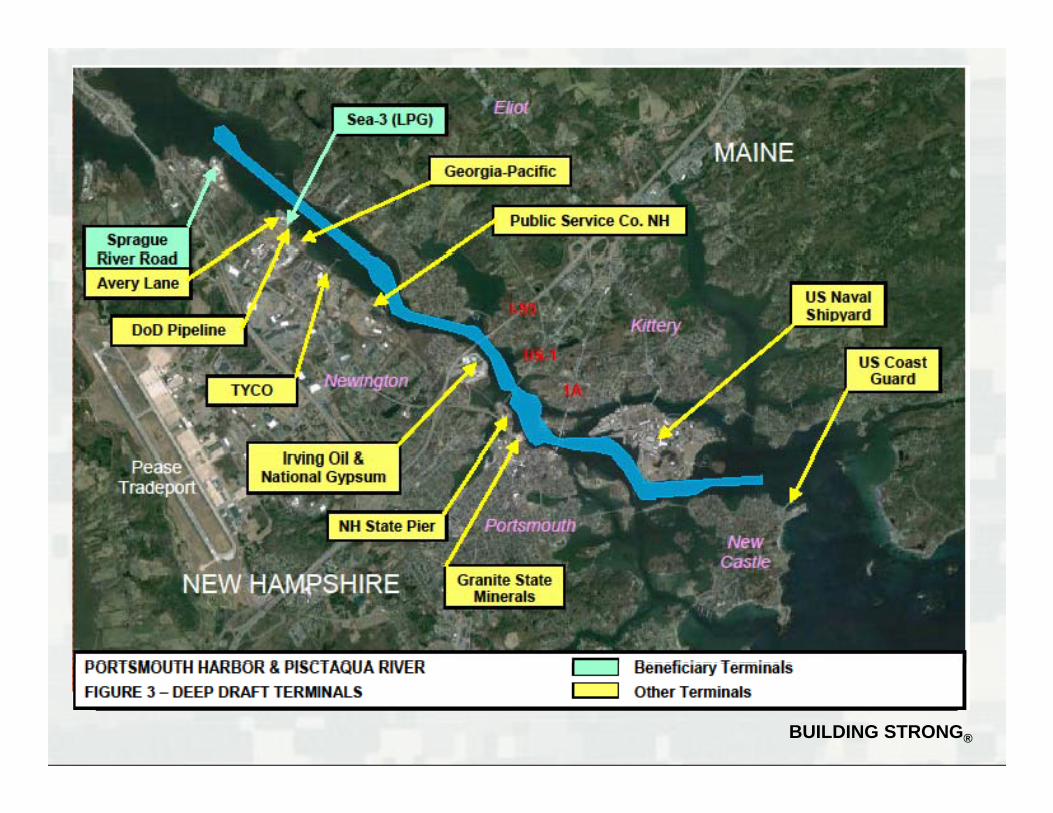
Avery Lane - Sea-3 LPG Terminalbelow Upper Turning Basin
BUILDING STRONG®
below Upper Turning Basin
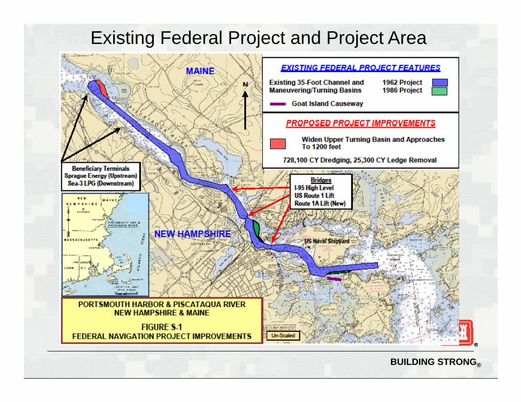
Existing Federal Project and Project Area
BUILDING STRONG®
Why Improve Portsmouth Harbor?y Portsmouth is New Hampshire’s Largest Port and Only Deep Draft Port
The 1964-66 Project (1962 R&HA) – 35-foot channel, 400 feet wide, designed for 35,000 DWT bulk carriers
The 1990-92 Modification (WRDA86) – Improved the Downstream Reaches below and Between the Bridges –– designed for 40-45,000 DWT bulk carriers. g gState of NH was Sponsor. Channel entrance reach widened opposite Naval Shipyard Channel widened along Badgers Island Turning/Maneuvering Area between Lift Bridges Expanded Upper Harbor Improvements not economically justified at that time.
2014 Upper Harbor Improvements – Ships continued to increase in size Users 2014 Upper Harbor Improvements – Ships continued to increase in size. Users looking to widen upper turning area so that upper terminals can also safely receive 45,000 DWT carriers up to 800 feet long.
BUILDING STRONG® 4
BUILDING STRONG®
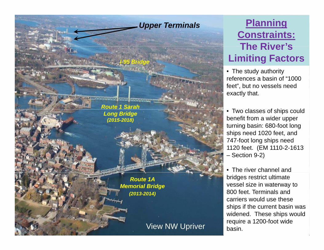
Upper Terminals Planning Constraints: The River’s
I-95 Bridge
The River s Limiting Factors
• The study authority references a basin of “1000
Route 1 Sarah
references a basin of 1000 feet”, but no vessels need exactly that.
T l f hi ldLong Bridge (2015-2018)
• Two classes of ships could benefit from a wider upper turning basin: 680-foot long ships need 1020 feet, and 747-foot long ships need747-foot long ships need 1120 feet. (EM 1110-2-1613 – Section 9-2)
• The river channel and Route 1A
Memorial Bridge(2013-2014)
bridges restrict ultimate vessel size in waterway to 800 feet. Terminals and carriers would use these
BUILDING STRONG®View NW Upriver
ships if the current basin was widened. These ships would require a 1200-foot wide basin.
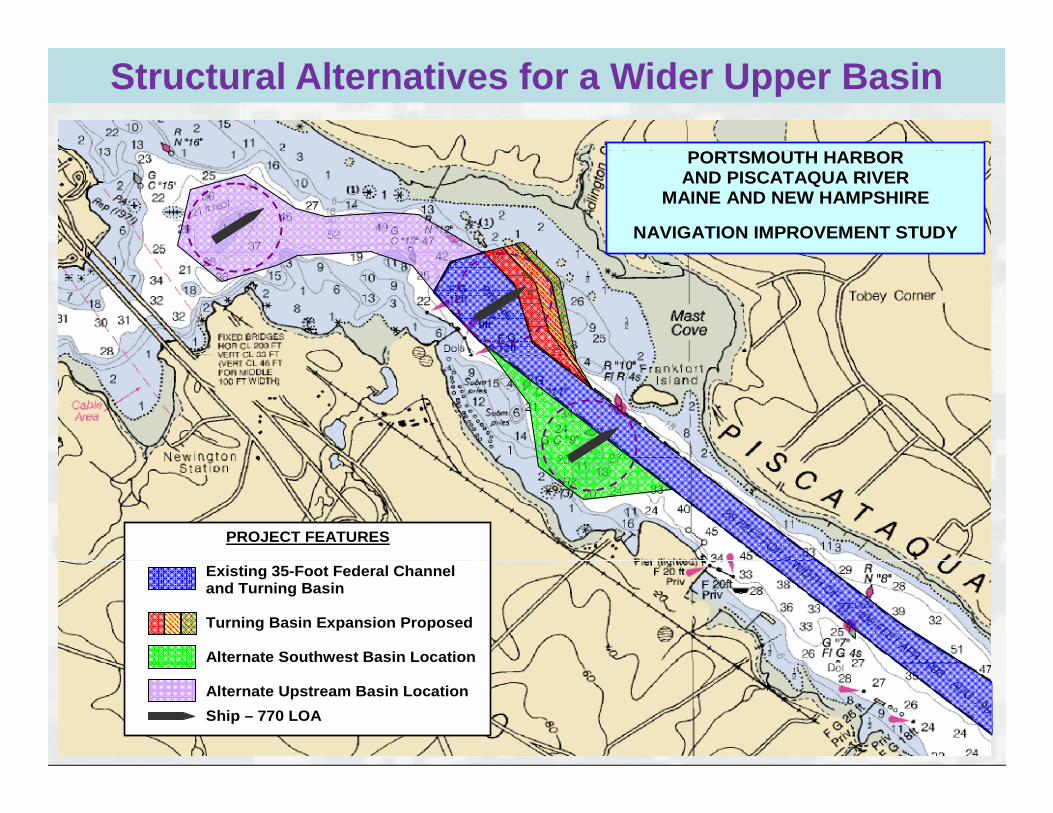
Structural Alternatives for a Wider Upper Basin
PORTSMOUTH HARBOR AND PISCATAQUA RIVER
MAINE AND NEW HAMPSHIRE
NAVIGATION IMPROVEMENT STUDY
PROJECT FEATURES
Existing 35-Foot Federal Channel and Turning Basin Turning Basin Expansion Proposed Alternate Southwest Basin Location
BUILDING STRONG®
Alternate Upstream Basin Location
Ship – 770 LOA

Recommended Plan Detail
Widen existing upper turning basin to 1200 feetturning basin to 1200 feet
Retain existing 35-foot j t d thproject depth
728,100 CY sandy glacial , y gtill plus 25,300 CY rock
Ocean Placement ofOcean Placement of dredged material and rock.
BUILDING STRONG®
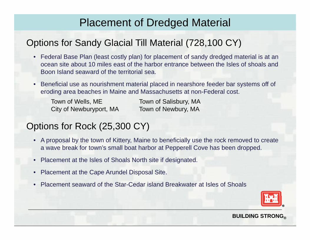
Placement of Dredged Material
Options for Sandy Glacial Till Material (728 100 CY)Options for Sandy Glacial Till Material (728,100 CY)• Federal Base Plan (least costly plan) for placement of sandy dredged material is at an
ocean site about 10 miles east of the harbor entrance between the Isles of shoals and Boon Island seaward of the territorial sea.
• Beneficial use as nourishment material placed in nearshore feeder bar systems off of eroding area beaches in Maine and Massachusetts at non-Federal cost.
Town of Wells, ME Town of Salisbury, MAyCity of Newburyport, MA Town of Newbury, MA
Options for Rock (25,300 CY)• A proposal by the town of Kittery, Maine to beneficially use the rock removed to create
a wave break for town’s small boat harbor at Pepperell Cove has been dropped.
• Placement at the Isles of Shoals North site if designated.
• Placement at the Cape Arundel Disposal Site.
• Placement seaward of the Star-Cedar island Breakwater at Isles of Shoals
BUILDING STRONG®
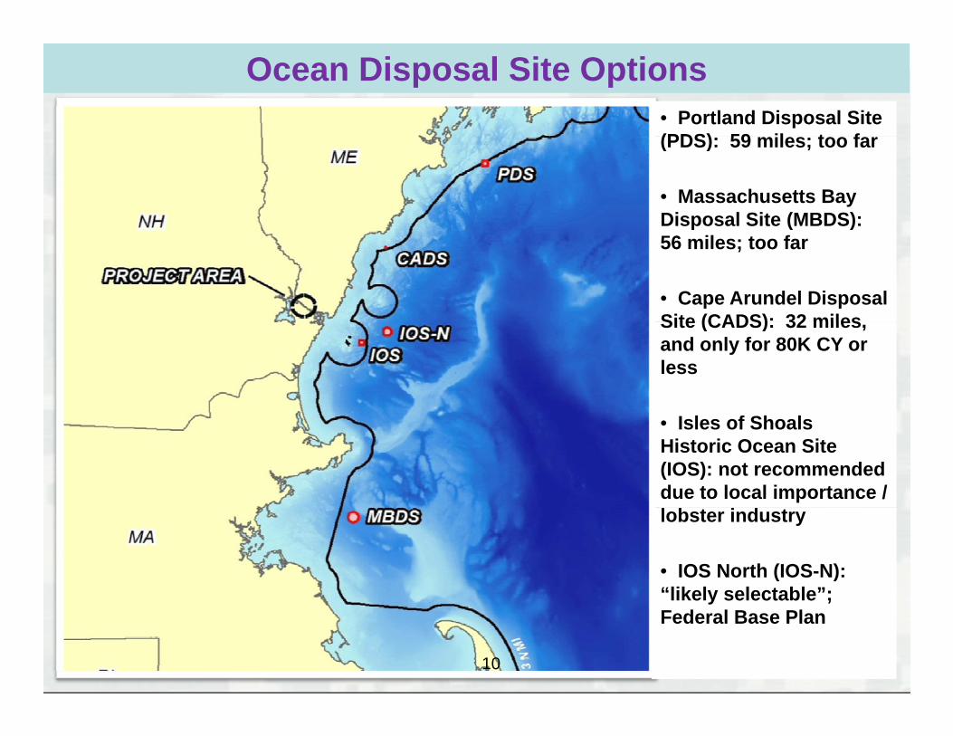
Ocean Disposal Site Options• Portland Disposal Site (PDS) 59 il t f(PDS): 59 miles; too far
• Massachusetts Bay Disposal Site (MBDS): p ( )56 miles; too far
• Cape Arundel Disposal Site (CADS): 32 milesSite (CADS): 32 miles, and only for 80K CY or less
• Isles of Shoals Historic Ocean Site (IOS): not recommended due to local importance / lobster industry
• IOS North (IOS-N): “likely selectable”;
BUILDING STRONG®
likely selectable ; Federal Base Plan
10
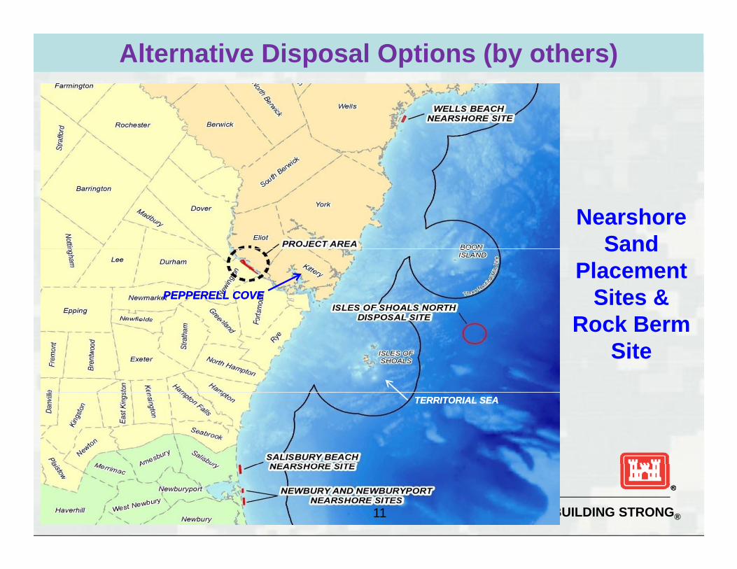
Alternative Disposal Options (by others)
Nearshore SandSand
Placement Sites &
Rock BermPEPPERELL COVEPEPPERELL COVE
Rock Berm Site
TERRITORIAL SEATERRITORIAL SEA
BUILDING STRONG®11
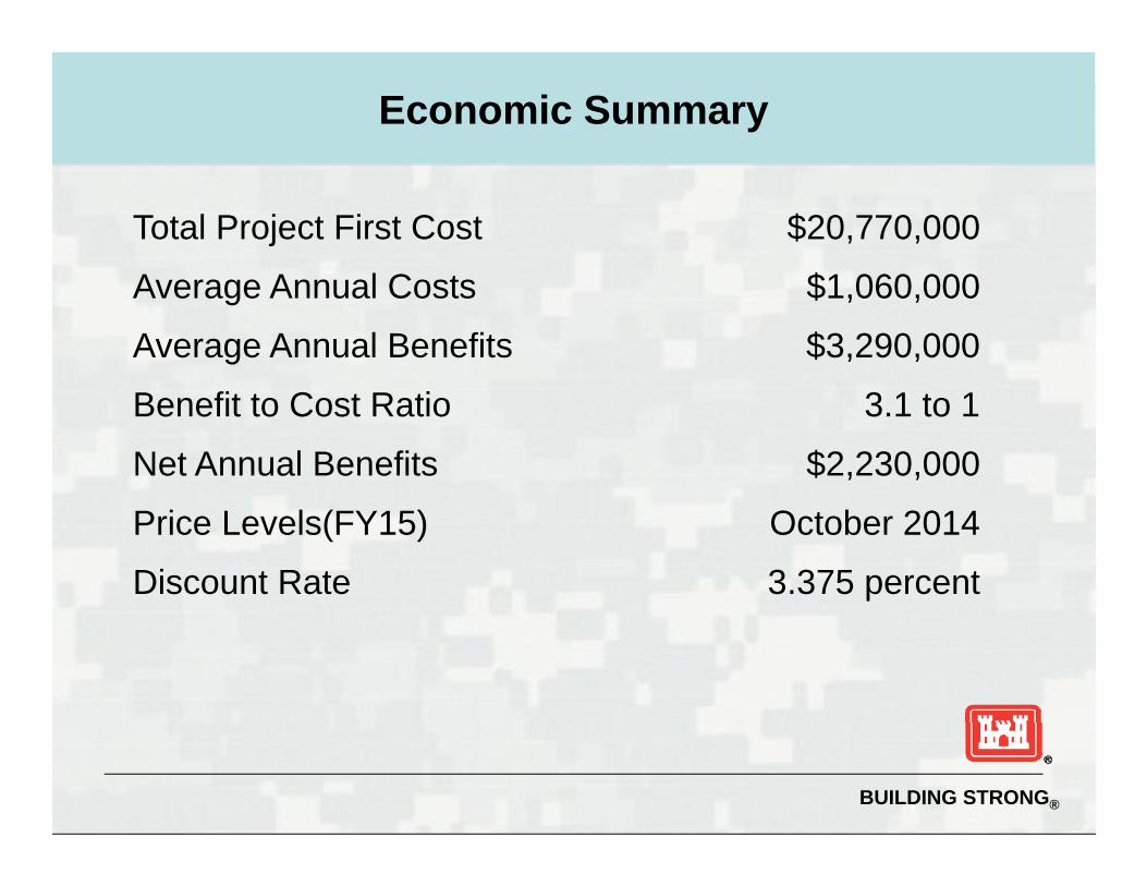
Economic Summary
Total Project First Cost $20,770,000
A A l C t $1 060 000Average Annual Costs $1,060,000
Average Annual Benefits $3,290,000
Benefit to Cost Ratio 3.1 to 1
Net Annual Benefits $2,230,000
Price Levels(FY15) October 2014
Discount Rate 3.375 percent
BUILDING STRONG®

PED Phase requires additional investigations / refinement of
PED Phase
PED Phase requires additional investigations / refinement of construction methods.
Explore subsurface ledge areas in the expanded turning basin to better- Explore subsurface ledge areas in the expanded turning basin to better determine the horizon between the glacial till and bedrock.
- Hydrographic survey of the proposed enlarged turning basinHydrographic survey of the proposed enlarged turning basin.
- Develop rock removal plan to minimize impacts to listed species, particularly from blasting.p y g
- Coordination with resource/regulatory agencies in our preparation of an Environmental Assessment for this project.
- Be prepared to use Isles of Shoals North ocean placement site; prepare Ocean Dumping Act Section 103 Site Selection memo for EPA concur.
BUILDING STRONG®13
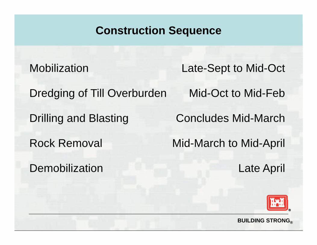
Construction Sequence
Mobilization Late-Sept to Mid-Oct
Dredging of Till Overburden Mid-Oct to Mid-Feb
Drilling and Blasting Concludes Mid-March
Rock Removal Mid-March to Mid-April
Demobilization Late AprilDemobilization Late April
BUILDING STRONG®

Project Implementation Schedule
P j t A d b th Ci il W k R i B d 21 A t 2014Project Approved by the Civil Works Review Board 21 August 2014
Chief of Engineers Report Signed 8 February 2015
Assistant Secretary of the Army Transmits Reports to Congress 15 June 2015
Design Agreement Execution mid October 2015
Project Partnering Agreement Execution* TBDj g g
Contract Award* TBD
Contract Completion* TBD
* Project requires Authorization in order to receive funding.
BUILDING STRONG®
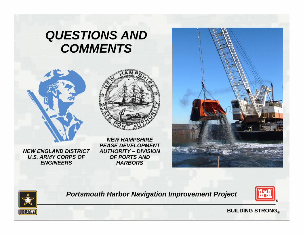
QUESTIONS AND COMMENTS
NEW ENGLAND DISTRICT U.S. ARMY CORPS OF
ENGINEERS
NEW HAMPSHIRE PEASE DEVELOPMENT AUTHORITY – DIVISION
OF PORTS AND HARBORSENGINEERS HARBORS
BUILDING STRONG®
Portsmouth Harbor Navigation Improvement Project