Embed Size (px)
Citation preview

US Army Research, Development and Engineering Command- Supporting the Objective Force -
Technology to the Warfighter Quicker
2004 COMMAND AND CONTROL RESEARCH AND TECHNOLOGY SYMPOSIUM15-18 June 2004
Positioning, Navigation and Timing (PNT):The Foundation of Command and Control
Presented By:Mr. Paul Olson, Chief, Positioning/Navigation and Timing Branch, Command and Control Directorate
(C2D), Communication-Electronics Research, Development and Engineering Center (CERDEC)[email protected]
Co-AuthorsDr. Raymond Filler, Mr. Steven Ganop, Dr. Stanley Sokolowski
US Army, Command and Control Directorate (C2D)
Major William FischerUS Army, Project Manager for Navigation Systems

PNT: The Foundation of Command and Control
Introduction
Positioning/Navigation (Pos/Nav) and Timing information is very critical to most military operations; paramount to Command and Control.
This Paper addresses
Evolving Role of PNT on the Battlefield
Army PNT User Requirements and Lessons Learned
Current PNT Shortfalls
Ongoing US Army Technology Program – Advanced Pos/Nav and Tracking the Future Force.

Expanding Role of Pos/Nav and Timing on a Digitized Battlefield
Traditional Role of position information is for own platformpilotage and low rate, non-automated Situation Awareness via Voice CommsEvolving Role of position information is as a shared resource. Automated high frequency position reporting provides a common blue force deployment picture, adds context to modern digital battlefield systems to enhance
Maneuver and Maneuver ControlLogisticsIntel Data FusionAir DefenseFire SupportMunitions Emplacement
The accuracy and availability of position and motion information directly affects the future Army’s C2 and Operational effectiveness.

Field Manual No. 100-14 : Defn. Situation Awareness
Situational Awareness
“ability to have accurate and real-time information on friendly, enemy, neutral, and noncombatant locations; a common, relevant picture of the battlefield scaled to specific level of interest and special need.

Joint Pub 1-02 : Defn. Command and Control
Command and Control
“The exercise of authority and direction by a properly designated commander over assigned and attached forces in the accomplishment of the mission. Command and control functions are performed through an arrangement of personnel, equipment, communications, facilities, and procedures employed by a commander in planning, directing, coordinating, and controlling forces and operations in the accomplishment of the mission.”
Conclusion: The better the situational awareness information, the better the decisions that the commander will make, and hence, the better execution of that mission.

Lessons Learned And User Requirements for PNTInside The Army, June 30, 2003, Pg. 1
“….an after-action report first reported last week by Inside the Army stated that a majority of soldiers brought their own commercial GPS receivers…”
TRADOC PAM 525-66 Force Operating Capabilities, Jan 2003FOC-03-01: Command and Control: (6) FOC-05-01: Mounted/Dismounted Maneuver: FOC-05-03: Operations in Urban and Complex Terrain: FOC-06-01: NLOS Lethality: (13) (e)
Operational Requirements Documents:Operational Requirements Documents for the Future Combat Systems (FCS)Land Warrior Capability Development Document (CDD) for Ground Soldier System, Block III
Essentially these can be summed up as
“Requirement: An Affordable Precise PNT Capability for All Environments/Conditions”

“'Friendly Fire' Deaths Traced to Dead Battery, Taliban Targeted, but U.S. Forces Killed”
The deadliest "friendly fire" incident of the war in Afghanistan was triggered in December by the simple act of a U.S. Special Forces air controller changing the battery on a Global Positioning System device he was using to target a Taliban outpost north ofKandahar, a senior defense official said yesterday. Three Special Forces soldiers were killed and 20 were injured when a 2,000-pound, satellite-guided bomb landed, not on the Taliban outpost, but on a battalion command post occupied by American forces and a group of Afghan allies, including Hamid Karzai, now the interim prime minister….”
By Vernon LoebWashington Post Staff WriterSunday, March 24, 2002; Page A21
Inaccurate information may impose devastating consequences.
Impact of Inaccurate Pos/Nav/Timing Information

GPS is great… but it has some limitations
Multipath = Position ErrorMultipath =
Position Error
Interference = No Service
Interference = No Service
Blockage =No Service Blockage =No Service

“…. Once hailed as the only navigation system necessary for aviation and other modes of civil transportation, the role of GPS has been reevaluated in the last few years. GPS is accepted as an increasingly important component in the nation's transportation infrastructure, but it is no longer seen as a single-source solution ....”Volpe Journal 2003: Transportation and Security
The Volpe National Transportation Systems Center, US DOT
DOT understands the importance of GPS as part of the national infrastructure and recognizes the need for backups. Similarly so
should the Department of Defense.
US Department of Transportation : On GPS as a single source solution

Available Backups to GPS
Externally Referenced
Positioning/Navigation Systems/Sensors which are based on sources external to the platform.
Examples include Loran and other types of RF Ranging.
System errors are generally consistent over time and distance traveled.
Limitations are the availability of observations from the source.
Self-Contained
Positioning/Navigation Systems/Sensors whose functions are soley based on observations experienced by the platform.
Examples include Inertial Navigation Systems and other types of Dead Reckoning systems.
System errors generally degrade with respect to time and/or distance traveled.

Need more than one tool in the toolbox
Different Jobs Require Different Tools andSome Jobs Require Multiple Tools

Need more than one tool in the toolbox
Software G
PS
Software G
PS
RF
Positioning/RangingRF
Positioning/RangingMEMS IMUMEMS IMU
Networked
Assisted
NavigationNetworked
Assisted
Navigation
System Integration Technology
System Integration Technology
Different Jobs Require Different Tools andSome Jobs Require Multiple Tools
Pedom
etry/D
ead
Recko
ning
Pedom
etry/D
ead
Recko
ning

CurrentCommercial system
C/A code onlyCell Phone
Demonstrated with SINCGARS
Ongoing DevelopmentDevelop P/Y Code Algorithms (Military) Interface with or embed in military radio system
FutureInvestigations into the entre’ in Network Centric Warfare
ImprovedPositionAccuracy
Operates inDegraded
Environment
Based onCommercialTechnology
Tactical Internet(e.g. EPLRS,SINCGARS)
LocationServer
SA & GPS
Aiding Data
SA Reports &
Data for Aiding
GPSSatellites
GPS Rcvr
Network Assisted GPS
ShortenedAcquisition
Time

“Dead Reckoning” Device Enhancements
LimitationsRequires careful control of stride, i.e. walking upright and “rocking steady”Cannot distinguish between steps that result in horizontal movement and vertical movement
EnhancementsImproved Human Motion Modeling to account for running, crawling, pacing, crab-walking, etc.Additional sensors and/or improved sensor processing for the detection of vertical motion to compensate for stair climbing
The Land Warrior Nav subsystem uses measurements of distance traveled (DT) and heading to calculate position. DT is measured using an accelerometer triad to detect and count user steps.

Lightweight
ContinuousOperation
Leveraging fromMissile/Munitions
Optimizing forSoldier/Vehicles
GPS Calibrates
Inertial Errors
1000 2000 3000 4000 5000 6000 7000 8000 9000
-4
-3
-2
-1
0
1
2
3
4
Attitude Error with ADXL Gyro (deg)
Time (sec)
PitchRollHeading
Integration of MEMS Inertials with GPS
No Electronic Signature

Self Contained Navigation System Performance
Self Contained navigation systems have errors that drift with time and/or distance traveled.Lower quality systems are adequate for short duration missions (missiles/munitions).Higher quality systems are required for longer missions (soldiers, vehicles, aircraft) and require integration with precision velocity aiding.
Continuous Precision Velocity Aiding
Err
or G
row
th
Time or Distance Traveled
Low Quality Inertiale.g. 1.0-100 deg/hr
Dead Reckoning Devicee.g. 1.0 % DT
High Quality Inertiale.g. 0.01 – 0.4 deg/hr
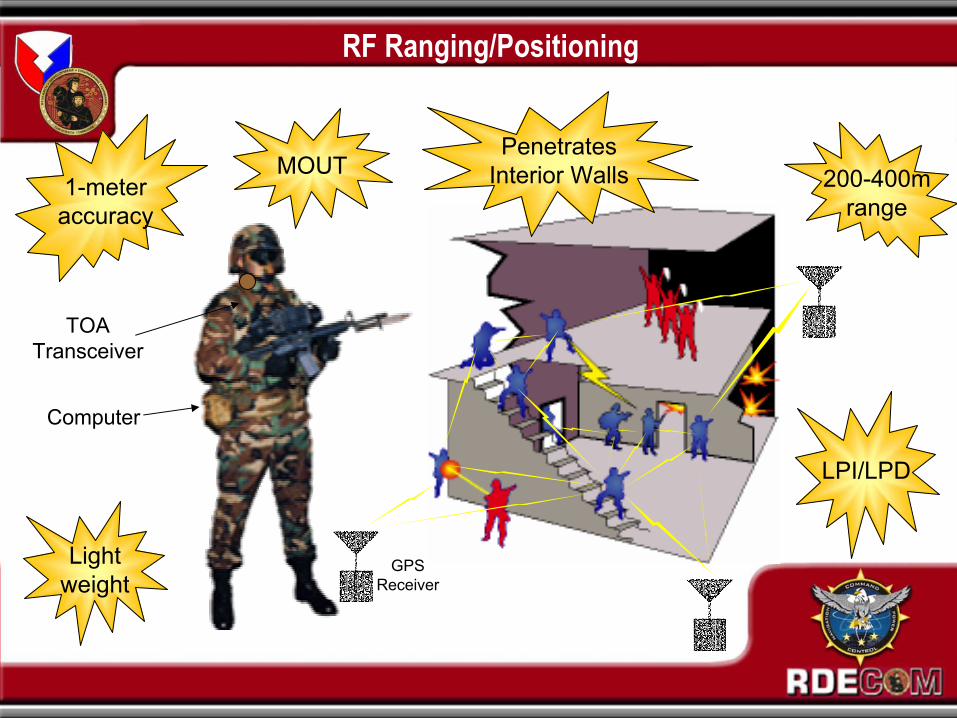
Lightweight
1-meteraccuracy
MOUT
Computer
TOATransceiver
RF Ranging/Positioning
Penetrates Interior Walls
LPI/LPD
200-400mrange
GPSReceiver

PNT: The Foundation of Command and ControlSummary
Positioning, Navigation and Timing (PNT) information is enormously important to the Warfighter, the Commander, and hence to all Command and Control.
Size, Weight, Power and Cost have been traditionally performancelimiting factors in PNT equipment.
CERDEC undergoing efforts to overcome these limiting factors by employing:
Advanced MEMS IMUs
Software GPS Receivers
Employ RF Ranging
Datalinks to Assist GPS Performance
Merging Communication and Navigation Functions
Positioning, Navigation, and Timing:The Foundation of Command and Control
You bet – and More.

Assured Positioning/Navigation
RF Positioning/Ranging
RF Positioning/Ranging
Network AssistedNavigation
Network AssistedNavigation
SystemIntegrationTechnology
SystemIntegrationTechnology
Improved MEMS IMUsfor Soldiers and Ground Vehicles
Improved MEMS IMUsfor Soldiers and Ground Vehicles
Software GPSReceivers
Software GPSReceivers
Pedometry/Dead Reckoning
Pedometry/Dead Reckoning