Embed Size (px)
Citation preview

1 June 2013.
In cooperation with the City of Cambridge, Massachusetts, CDM Smith has prepared this Post Construction Evaluation Report to evaluate changes in the Concord Avenue corridor, from Blanchard Road to Alewife Brook Parkway, between pre- and post-construction conditions of the Concord Avenue Roadway and Water Main Improvements Project (Project).
The Project included the installation of raised cycle tracks, rapid pedestrian warning flashers, green space, pavement markings, and reconstruction of existing sidewalks to be ADA/AAB compliant. The purpose of this report is to document pre- and post-construction pedestrian and bicycle travel conditions along the corridor, and the effect these changes have had on vehicle speeds, bicycle activity and yielding to pedestrians.
Concord Avenue is located between Alewife Brook Parkway and Blanchard Road and serves as an east-west connection between the towns of Belmont, Cambridge and Boston. The Project corridor along Concord Avenue is approximately 3,700 feet long (0.70 miles). The south side of the roadway runs along the Fresh Pond Reservation while land uses north of the roadway are a mix of retail, industrial and office. There is also a private elementary/middle school located at the corner of Concord Avenue and Spinelli Place. Figure 1 illustrates the project location.
The purpose of the Project was to install a new water main along Concord Avenue and provide improved pedestrian and bicyclist accommodations. Specific goals include:
• Provision of a dedicated bicycle travel way in both directions
• Provision of an improved walking surface for pedestrians
• Provision of improved crossing areas for pedestrians and bicyclists
• Encouragement of reduced motor vehicle speeds along the corridor
[HEADING 1_SECTION TITLE]
POST CONSTRUCTION EVALUATION REPORT CONCORD AVENUE CAMBRIDGE, MASSACHUSETTS

Concord Avenue Post Construction Evaluation Report
2
May 2013
Fresh Pond
Fresh Pond Reservation
Alewife Brook Parkway
Blanchard Road
Figure 1 Aerial photo of the project corridor, courtesy of CDM Smith
Spinelli Place
Moulton Street
Wheeler Street
Fawcett Street
Smith Place
Concord Avenue

Concord Avenue Post-Construction Evaluation Report
3
May 2013
Pre-and Post-Construction Conditions
Pre-construction Conditions Concord Avenue was constructed in 1934, and until the last decade, consisted of a four lane roadway with two lanes in each direction, and sidewalks on both sides.
In 2000, the travel lanes of the corridor were re-striped to provide 5’-wide bicycle shoulders along both sides by eliminating one of the two westbound travel lanes. This resulted in a 3-lane cross section, two lanes eastbound and one lane westbound.
In 2004 one of the eastbound lanes on Concord Avenue west of Spinelli Place was converted into an exclusive left turn lane with a painted median extending back to the intersection with Blanchard Avenue. In addition a median island was painted on the east leg of the intersection to shadow the westbound left turn.
Post-construction Conditions Construction of the Project began in early 2010 and was substantially completed in early 2012. Following the water main installation, the following major surface components were constructed:
Raised cycle tracks on both sides of the roadway to create horizontal and vertical separation between bicyclists and motor vehicle traffic.
Reduced overall pavement width by relocating the existing granite curbing closer to the travel lane to encourage reduced motor vehicle speeds
Connected the existing Fresh Pond Reservation multi-use trail with the new cycle track.
Construction of cement concrete sidewalks and pedestrian crossing areas.
The pre- and post-construction conditions along the corridor are summarized in Table 1. Pre- and Post- construction condition photos are illustrated in the Appendix.
Concord Avenue looking east (photo courtesy Cambridge Historical Commission)
Concord Avenue looking west (2009)
Pedestrians, bicyclists and vehicles on Concord Avenue looking west (2012)

Concord Avenue Post-Construction Evaluation Report
4
May 2013
Table 1: Pre- versus Post-Construction Conditions along Concord Avenue
Pre-Construction Conditions Post Construction Conditions
Curb-to-curb pavement width:
44 feet, west of Spinelli Place
44 feet, east of Spinelli Place
Curb-to-curb pavement width:
25 feet, west of Spinelli Place
34 feet, east of Spinelli Place
5-foot wide asphalt bicycle lanes (level with the travel way)
5-foot wide asphalt raised cycle tracks (3-inch to 6-inch granite curb reveal)
7 to 8-foot cement concrete sidewalks in varying conditions; non-ADA compliant driveway aprons and pedestrian ramps
5-foot minimum cement concrete sidewalk with a 2-foot wide scored buffer between walking area and cycle track area; ADA compliant driveway aprons and pedestrian ramps
Unsignalized crosswalks at Spinelli Place, Smith Place and Fawcett Street
Crossing areas supplemented with “shark tooth” yield markings and R1-5L “Yield Here to Pedestrians” signing
Spinelli Place – scored concrete median island (flush)
Fawcett Street, Smith Place –push-button activated flashing pedestrian warning devices
Additional features of the project included:
All sidewalk furniture (signs, hydrants, street lights, etc.) along the Reservation side (south side) of Concord Avenue was relocated behind the new sidewalk to facilitate snow removal
All sidewalk furniture along the north side was maintained between the sidewalk area and the raised cycle track area (within the 2-foot wide scored buffer).
A landscaped area was provided between the travel way and the cycle track along the north side of Concord Avenue between Spinelli Place and Blanchard Road to enhance the walking and bicycling experience.
Existing and proposed trees located within the sidewalk area were treated with a rubberized porous walking surface to accommodate pedestrians and cyclists without damaging existing healthy trees.

Concord Avenue Post-Construction Evaluation Report
5
May 2013
Pre- vs. Post-Construction Analysis Overall data collection efforts following construction completion were performed by CDM Smith in September and October 2012.
Turning Movement Count Collection CDM Smith collected post-construction turning movement data at the following locations during the week of September 10, 2012:
a. Concord Avenue/Blanchard Road/Griswold Street b. Concord Avenue/Smith Place c. Concord Avenue/Mouton Street d. Concord Avenue/Fawcett Street e. Concord Avenue/ Wheeler Street
Data was collected for motor vehicles, pedestrians, and bicyclist during the weekday morning (7am to 10am) and weekday evening (4pm to 7pm) peak hours. Table 2 summarizes the increase in traffic volume during the morning and evening peak hours from pre- to post-construction. A full account of the turning movement data can be found in the Appendix.
Table 2: Pre- versus Post-Construction Changes in Peak Hour Vehicle Volumes
Intersection Increase in Volume
Northbound Approach
Southbound Approach
Westbound Approach
Eastbound Approach
Blanchard Road/ Griswold Street
AM 4% 32% -17% -6% PM -13% 19% -3% 15%
Smith Place AM - -17% 1% 16% PM - 9% -18% 15%
Moulton Street AM -27% 54% -2% 11% PM 39% 19% -13% 11%
Fawcett Street AM - 30% -9% 14% PM - -12% -17% 16%
Wheeler Street AM - -17% 11% 25% PM - 4% -1% 15%
Beyond the traffic volume data, three main areas of analysis were performed on the Concord Avenue corridor to compare pre- and post-construction conditions with respect to pedestrians, bicyclists and motorists: vehicle speeds, sidewalk and cycle track use, and pedestrian yielding.
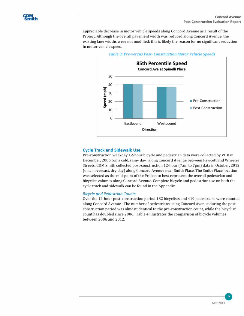
Vehicle Speeds Pre-construction speed data on Concord Avenue were collected and documented in a Vollmer Associates report dated July, 2005 near the intersection at Spinelli Place. Post-construction speed data were collected in September, 2012 at the Spinelli Place intersection as well as two additional locations along Concord Avenue. The September 2012 data were collected using 96-hour Automatic Traffic Recorder (ATR) counts and included motor vehicle classification and speeds. Figure 2 illustrates the speed data collection locations and the complete data results are included in the Appendix.
Table 3 illustrates the results of the post-construction speed data as compared with the pre-construction data collected in 2005. The speed data collection indicates there is no
Concord Avenue Post-Construction Evaluation Report
6
May 2013
appreciable decrease in motor vehicle speeds along Concord Avenue as a result of the Project. Although the overall pavement width was reduced along Concord Avenue, the existing lane widths were not modified; this is likely the reason for no significant reduction in motor vehicle speed.
Table 3: Pre-versus Post- Construction Motor Vehicle Speeds
Cycle Track and Sidewalk Use Pre-construction weekday 12-hour bicycle and pedestrian data were collected by VHB in December, 2006 (on a cold, rainy day) along Concord Avenue between Fawcett and Wheeler Streets. CDM Smith collected post-construction 12-hour (7am to 7pm) data in October, 2012 (on an overcast, dry day) along Concord Avenue near Smith Place. The Smith Place location was selected as the mid-point of the Project to best represent the overall pedestrian and bicyclist volumes along Concord Avenue. Complete bicycle and pedestrian use on both the cycle track and sidewalk can be found in the Appendix.
Bicycle and Pedestrian Counts Over the 12-hour post-construction period 182 bicyclists and 419 pedestrians were counted along Concord Avenue. The number of pedestrians using Concord Avenue during the post-construction period was almost identical to the pre-construction count, while the bicyclist count has doubled since 2006. Table 4 illustrates the comparison of bicycle volumes between 2006 and 2012.
0
10
20
30
40
50
Eastbound Westbound
Spee
d (m
ph)
Direction
85th Percentile Speed Concord Ave at Spinelli Place
Pre-Construction
Post-Construction

Concord Avenue Post-Construction Evaluation Report
7
May 2013
Table 4: Pre- vs. Post-Construction 12-hour Bicycle Counts
Although there has been an overall increase in the number of daily bicyclists, the data collected during the morning and peak hours do not illustrate a noticeable difference between pre- and post-construction conditions. Table 5 illustrates a comparison between bicycle counts during the morning and evening peak hours. The overall daily increase, but insignificant peak hour change, indicates that the new cycle tracks may be favored more by recreational bicyclists than by commuters. It is recommended that additional bicyclist data be collected over the coming years to see if commuter volumes increase.
Table 5: Pre- versus Post-Construction Peak Hour Bicyclist Count
Direction 2006 Count1 2012 Count
AM Peak PM Peak AM Peak PM Peak Eastbound 16 11 14 8 Westbound 7 20 9 20
1Source - Figure 2c.4: 2006 Existing Bike Volumes, VHB, 2007
0
20
40
60
80
100
Westbound Eastbound
Num
ber o
f Bic
ycle
s Direction of Travel
12-Hour Bicycle Counts
Pre-construction
Post-construction

Concord Avenue Post Construction Evaluation Report
8
May 2013
Figure 2 data collection points
2012 Speed data collection point
2012 Speed data collection point
2005/2012 Speed data collection point
2006 Bicyclist and pedestrian data collection point
2012 Bicyclist and pedestrian data collection point

Concord Avenue Post-Construction Evaluation Report
9
June 2013
One consistent observation during the 2012 post-construction count is that bicyclists prefer to use the cycle track versus on-road bicycling. Of the 182 bicyclists observed during the 12-hour period, only one did not use the cycle track or sidewalk. This rider instead chose to ride in a motor vehicle travel lane on the road. Another observation made during the count was that school-aged children that bike to/from school tend to use the southern cycle track regardless of the direction they may be heading.
Direction of Travel
Pedestrians During the 2012 collection period, approximately three quarters of pedestrians observed during the post-construction period were located on the north side of Concord Avenue, where there is a greater concentration of varied land use. The direction of travel was almost a 50/50 split with 52% eastbound and 48% westbound.
Post construction, of the 419 pedestrians counted, only 13, or 3.1%, were observed walking within the cycle track area and not the sidewalk area. During the count it was also observed that pedestrian use of the cycle tracks occurred either during the lunch hour when pedestrians were walking in large groups, or where existing trees or shrubbery had narrowed the ‘available’ sidewalk width.
Bicyclists The post-construction collection period data demonstrates that approximately 57% of bicyclists utilized the south side of Concord Avenue. This is a change from the pre-construction collection period, which observed a majority of bicyclists on the north side of the road. This uneven split is likely due to the connection between the cycle track and the existing multi-use trail located around the Fresh Pond Reservation and further confirms the assessment that the cycle tracks are utilized more by recreational riders than by commuters. The direction of travel was split almost 50/50, with 53% eastbound and 47% westbound, which closely mirror the 2006 VHB pre-construction count.
Bicyclists traveling opposite the direction of vehicular traffic, or contra-flow, were observed on both sides of Concord Avenue. Contra-flow bicyclists within the cycle tracks are considered those travelling westbound while on the southern side of the road or travelling eastbound while on the north side. Contra-flow riders represented 12% and 16 % of the total cyclists on the north side and south sides of Concord Avenue, respectively.
Pedestrian-Bicyclist conflicts Following substantial construction completion, it was noted that passengers alighting and boarding buses along the corridor would do so in the cycle track and potentially create unnecessary pedestrian-bicyclist conflicts. Therefore, the cycle tracks were painted green at the location of bus stops, so that pedestrians would
Concord Avenue (2012)

Concord Avenue Post-Construction Evaluation Report
10
June 2013
be more aware of the potential presence of bicyclists and bicyclists would be alerted to yield to pedestrians. The green paint is the same paint used to mark areas where motor vehicles cross over existing bicycle lanes. In addition to the green painted area, a sign indicating “Bikes must yield at bus stops” was created to make encourage bicyclists to yield to pedestrians alighting and boarding buses along the corridor.
“Bikes Yield at Bus Stops” Sign
Painted cycle track with sign at Smith Place along Concord Avenue
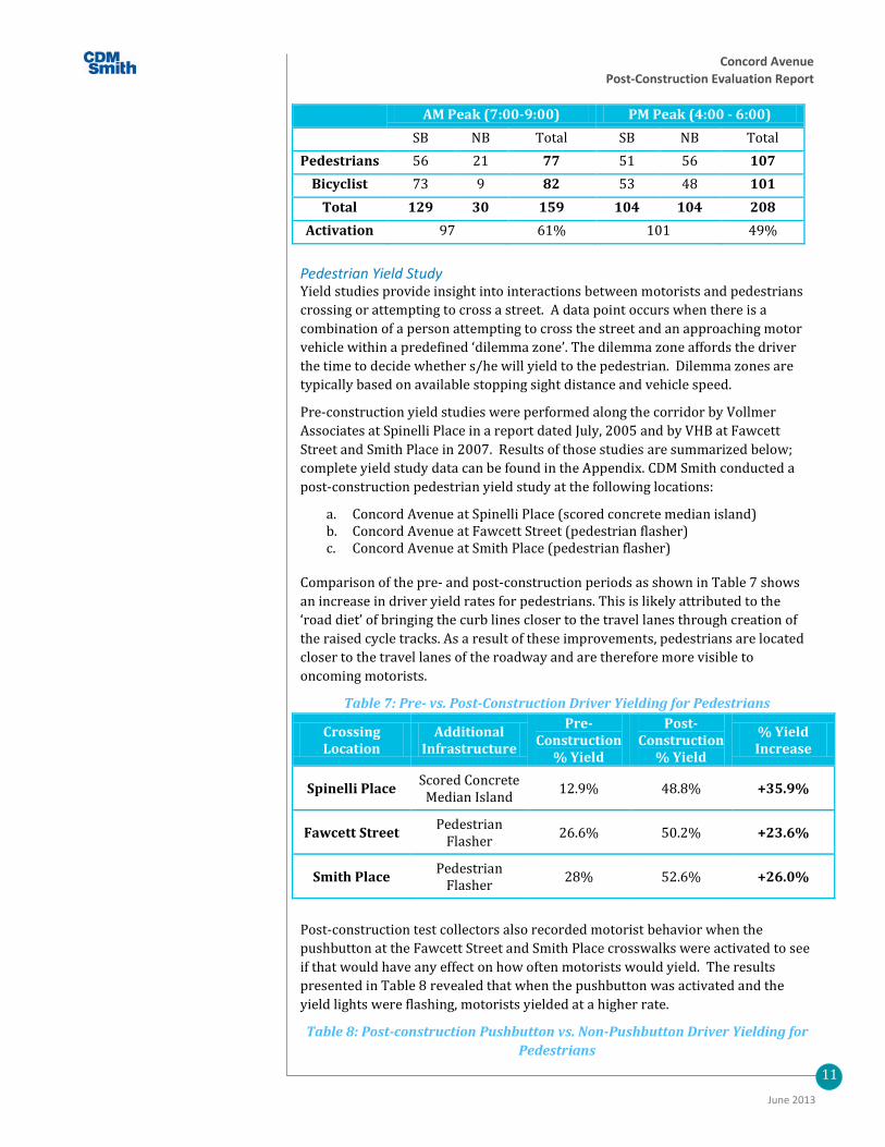
Wheeler Street Crossing Count data was also collected at the signalized crosswalk west of Wheeler Street during the week of September 10, 2012.
This crosswalk experiences high use during both the morning and evening peak hours. The use of the crosswalks is split nearly evenly between pedestrians and bicyclists regardless of the time of day, with 77 pedestrians and 82 bicyclists in the morning and 107 pedestrians and 101 bicyclists in the evening.
Although there is a pedestrian push button to activate the traffic signals, during the morning, 61% of pedestrians and bicyclists activate the pushbutton to facilitate their crossing; during the evening the pushbutton is activated by only 49% of crossing pedestrians or bicyclists. Table 6 summarizes pedestrian and bicyclist volumes during the morning and evening peak hours.
Table 6: Wheeler Street Crosswalk Pedestrian and Bicyclist Peak Hour Count
Concord Avenue Post-Construction Evaluation Report
11
June 2013
AM Peak (7:00-9:00) PM Peak (4:00 - 6:00) SB NB Total SB NB Total
Pedestrians 56 21 77 51 56 107 Bicyclist 73 9 82 53 48 101
Total 129 30 159 104 104 208 Activation 97 61% 101 49%
Pedestrian Yield Study Yield studies provide insight into interactions between motorists and pedestrians crossing or attempting to cross a street. A data point occurs when there is a combination of a person attempting to cross the street and an approaching motor vehicle within a predefined ‘dilemma zone’. The dilemma zone affords the driver the time to decide whether s/he will yield to the pedestrian. Dilemma zones are typically based on available stopping sight distance and vehicle speed.
Pre-construction yield studies were performed along the corridor by Vollmer Associates at Spinelli Place in a report dated July, 2005 and by VHB at Fawcett Street and Smith Place in 2007. Results of those studies are summarized below; complete yield study data can be found in the Appendix. CDM Smith conducted a post-construction pedestrian yield study at the following locations:
a. Concord Avenue at Spinelli Place (scored concrete median island) b. Concord Avenue at Fawcett Street (pedestrian flasher) c. Concord Avenue at Smith Place (pedestrian flasher)
Comparison of the pre- and post-construction periods as shown in Table 7 shows an increase in driver yield rates for pedestrians. This is likely attributed to the ‘road diet’ of bringing the curb lines closer to the travel lanes through creation of the raised cycle tracks. As a result of these improvements, pedestrians are located closer to the travel lanes of the roadway and are therefore more visible to oncoming motorists.
Table 7: Pre- vs. Post-Construction Driver Yielding for Pedestrians
Crossing Location
Additional Infrastructure
Pre-Construction
% Yield
Post-Construction
% Yield
% Yield Increase
Spinelli Place Scored Concrete Median Island 12.9% 48.8% +35.9%
Fawcett Street Pedestrian Flasher 26.6% 50.2% +23.6%
Smith Place Pedestrian Flasher 28% 52.6% +26.0%
Post-construction test collectors also recorded motorist behavior when the pushbutton at the Fawcett Street and Smith Place crosswalks were activated to see if that would have any effect on how often motorists would yield. The results presented in Table 8 revealed that when the pushbutton was activated and the yield lights were flashing, motorists yielded at a higher rate.
Table 8: Post-construction Pushbutton vs. Non-Pushbutton Driver Yielding for Pedestrians

Concord Avenue Post-Construction Evaluation Report
12
June 2013
Crossing Location
Pushbutton Not Activated
% Yield
Pushbutton Activated % Yield
% Yield Increase
Fawcett Street 43.1% 57.4% +14.3%
Smith Place 50.3% 54.8% +4.5%
The data summarized in Table 9 shows that the direction in which the pedestrian is crossing may make a difference in yielding distance. Northbound pedestrians were afforded an average stopping distance of 100 feet while southbound pedestrians found motorists yielding at an average distance of 55 feet. This disparity could be due to the visibility of pedestrians on one side of the street being higher than the other. However, it is more likely that the disparity occurs due to the presence of two travel lanes versus one.
Table 9: Stopping Distance at Pedestrian Crossings
Crossing Location
Average Stopping Distance Northbound
Average Stopping Distance Southbound
Spinelli Place 90 ft 65 ft
Fawcett Street 75 ft 70 ft
Smith Place 100 ft 55 ft
It is important to note that even though motorists are clearly more likely to yield if the warning flashers are activated, this did not necessarily create a change in average stopping distance. Table 10 summarizes the average stopping distances recorded when pedestrians did and did not utilize the pushbutton.
Table 10: Pushbutton vs. Non-Pushbutton Stopping Distance at Pedestrian Crossings
Crossing Location
Pushbutton Not Activated Avg. Stopping distance
Pushbutton Activated Avg. Stopping Distance
Fawcett Street 75 ft 70 ft
Smith Place 70 ft 80 ft
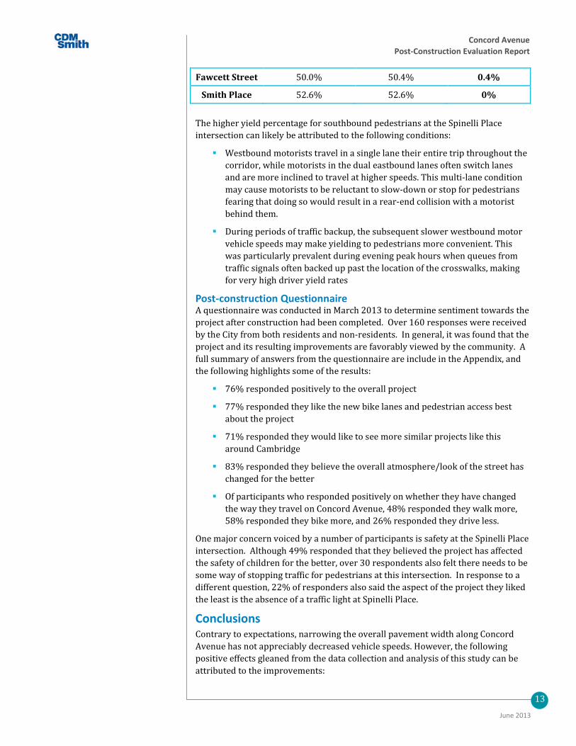
Although not recorded in the pre-construction VHB study, the post-construction yield study makes note of the direction pedestrians are traveling in. As shown in Table 11, this data shows a higher yield rate for pedestrians traveling southbound at the Spinelli Place intersection. There was no noticeable difference at either the Fawcett Street or Smith Place intersections between pedestrian direction and average vehicle stopping distance.
Table 11: Pre- vs. Post-Construction Pedestrian Travel Directions
Crossing Location
% Yield Southbound Pedestrians
% Yield Northbound Pedestrians
Difference in Yield %
Spinelli Place 56.5% 42.4% 14.1%
Concord Avenue Post-Construction Evaluation Report
13
June 2013
Fawcett Street 50.0% 50.4% 0.4%
Smith Place 52.6% 52.6% 0%
The higher yield percentage for southbound pedestrians at the Spinelli Place intersection can likely be attributed to the following conditions:
Westbound motorists travel in a single lane their entire trip throughout the corridor, while motorists in the dual eastbound lanes often switch lanes and are more inclined to travel at higher speeds. This multi-lane condition may cause motorists to be reluctant to slow-down or stop for pedestrians fearing that doing so would result in a rear-end collision with a motorist behind them.
During periods of traffic backup, the subsequent slower westbound motor vehicle speeds may make yielding to pedestrians more convenient. This was particularly prevalent during evening peak hours when queues from traffic signals often backed up past the location of the crosswalks, making for very high driver yield rates
Post-construction Questionnaire A questionnaire was conducted in March 2013 to determine sentiment towards the project after construction had been completed. Over 160 responses were received by the City from both residents and non-residents. In general, it was found that the project and its resulting improvements are favorably viewed by the community. A full summary of answers from the questionnaire are include in the Appendix, and the following highlights some of the results:
76% responded positively to the overall project
77% responded they like the new bike lanes and pedestrian access best about the project
71% responded they would like to see more similar projects like this around Cambridge
83% responded they believe the overall atmosphere/look of the street has changed for the better
Of participants who responded positively on whether they have changed the way they travel on Concord Avenue, 48% responded they walk more, 58% responded they bike more, and 26% responded they drive less.
One major concern voiced by a number of participants is safety at the Spinelli Place intersection. Although 49% responded that they believed the project has affected the safety of children for the better, over 30 respondents also felt there needs to be some way of stopping traffic for pedestrians at this intersection. In response to a different question, 22% of responders also said the aspect of the project they liked the least is the absence of a traffic light at Spinelli Place.
Conclusions Contrary to expectations, narrowing the overall pavement width along Concord Avenue has not appreciably decreased vehicle speeds. However, the following positive effects gleaned from the data collection and analysis of this study can be attributed to the improvements:

Concord Avenue Post-Construction Evaluation Report
14
June 2013
Relocating the existing curb inward five-feet on either side of Concord Avenue has improved the visibility of pedestrians waiting on the curb at each pedestrian crossing.
The installation of flashing pedestrian warning devices at the unsignalized Smith Place and Fawcett Street crossings have increased the percentage of motorists yielding to pedestrians.
The provision of raised cycle tracks along Concord Avenue has resulted in an overall increase in daily bicycle activity.
Peak hour (commuter) bicycle volumes have not increased appreciably.
The installation of the cycle track better connects users to the multi-use trail along the Fresh Pond Reservation on the south side of the roadway.
Based on the questionnaire results, the community sees the project as having a positive effect on safety for bicyclists, pedestrians, and motorists. Many respondents indicated they have increased their biking and walking activities in the area as a result.