Embed Size (px)
Citation preview

June 28th - 30th 2017, Liptovsky Jan, Slovakia, EU
104
POTENTIAL OF SATELLITE-BASED EARTH OBSERVATION USE IN LOGISTICS
LENORT Radim, WICHER Pavel, STAŠ David, HOLMAN David
ŠKODA AUTO UNIVERSITY, Mlada Boleslav, Czech Republic, EU, [email protected]
Abstract
The paper presents study of the satellite-based Earth Observation use in logistics and supply chain
management. The study includes global market analysis (market perspectives, main market players, and sector segmentation), value-added services and products analysis, and logistics and supply chain
management applications analysis based on concrete case studies.
Keywords: Satellite-based Earth Observation, logistics, industrial company
1. INTRODUCTION
Nowadays, the satellite-based Earth Observation (EO) has many successful applications in a relative large
number of branches. It is based on satellite imaging technology, which enables to acquire optical or radar images of the Earth's surface with reasonable time and resolution. Thus, use of satellite-based EO appears
as very promising technology also in the area of logistics and supply chain management.
The aim of the paper is to analyse possibilities of the satellite-based EO in logistics and supply chain
management.
2. GLOBAL MARKET ANALYSIS
2.1. Market Perspectives
The satellite-based Earth Observation (EO) belongs, and will belong in the future, among very dynamic and
fast-growing world markets. This fact can be illustrated not only on the basis of historical data, but especially forecasts of leading international market research organizations. Northern Sky Research (NSR), a global
leader in Satellite & Space Market Research and Consulting Services, expects that projects data, value-added services, information products, and big data analytics from satellite-based EO will represent a $43 billion
opportunity over the next decade [1].
Technavio, a leading market research company with global coverage, states that by January 2014, around
190 EO satellites were orbiting the planet and this number is expected to increase to more than 350 satellites by the end of 2022. Technavio’s market research analyst predicts the global satellite-based EO market to grow
steadily at the Compound Annual Growth Rate of more than 14 % during the forecasted period [2].
2.2. Market Players
According to Technavio, the global satellite-based EO market is moderately competitive due to the presence of few large players [2]:
• Airbus Defence and Space
• DigitalGlobe
• DMC International Imaging (DMCii)
• ImageSat International
• MDA

June 28th - 30th 2017, Liptovsky Jan, Slovakia, EU
105
Currently, two-thirds of high-resolution commercial EO data sales come from only two companies: Airbus
Defence and Space and DigitalGlobe [3].
2.3. Sector Segmentation
EO data, value added services and products are utilized in sectors as follows [2]:
• Defence
• Weather forecast and meteorological application
• Location-Based Services (LBS)
• Energy
• Agriculture
• Insurance
• Mining and oil and gas
• Transport and logistics
• Telecommunication and utilities
• Living resources
• Disaster management
The defence sector accounted for more than 36 % of the market shares during 2015 and is expected to witness
a steady growth during the next decade [2].
3. VALUE-ADDED SERVICES AND PRODUCTS ANALYSIS
A comprehensive analysis of the satellite-based EO value-added services and products offered by 8 main market players enables categorization of these services and products into 11 groups. Based on Airbus Defence
and Space group pallet of services and products [4] they can be defined as follow:
• New images of a specific area - creation of the requested quality images of specific area in the future.
This group can be divided into next 3 categories: (1) ASAP (as soon as possible), (2) specific day from the future, and (3) series of images if a customer need to see changes.
• Historical images of a specific area - all mentioned companies have big archives of satellite images and offer access to them.
• Base maps - this kind of images usually display wider areas like states or counties. Base maps can provide a background of geographical context for the specific maps which customers want to create.
• Elevation images and maps - present elevation images, maps and models, which provides highly accurate height information (3D information).
• Infrared images - usage of infrared part of the optic spectrum.
• Images with detected changes - offering to spot, monitor and notify changes in the specific area or set of images. Analysis is usually performed by a special software and/or the team of trained analytics.
• Outputs with deep analysis - special analyses according to customer needs.
• Special software applications - there is several highly specific ready to use software on the market.
Customers can just buy the final software product and filled it up with their own imagery data.
• Special customize solutions & software - there is also possibility to cooperate on developing new
software or application, which will be built exactly for specific customer needs.
• Data services - all companies mentioned some variance in the delivering of products, mainly it is through
clouds, FTPs, hard disks, DVD. Some of them also provide data storage on their own servers.
• Training - training of customer employees in different kinds of tasks linked with satellite imaging. Mostly
in analysis of the satellite images or usage of the specialized software products and applications.

June 28th - 30th 2017, Liptovsky Jan, Slovakia, EU
106
4. LOGISTICS AND SCM APPLICATIONS ANALYSIS
Based on a deep analysis of 73 specific applications by main 8 market players, 9 applications related to logistics and supply chain management were identified. From these application, can be selected 4
representatives, which are described below.
4.1. ISI KINGFISHER
ISI KINGFISHER is a system developed by ImageSat International (ISI). The system combines sophisticated Artificial Intelligence and human expertise into a multi-layer, multi-sensor maritime intelligence solution, which
provide coverage of enormous and dispersed surfaces and deliver vessel-specific insights and alerts. The system is used for sovereignty control, counter terrorism and piracy, counter trafficking, counter IUU fishing,
and environmental protection [5].
Used technology:
• Very high resolution radar and optical satellite imagery
• Coastal radar
• Other maritime data sources
Benefits from the logistics viewpoint:
• Automatic identification and classification of vessels (see Figure 1).
Figure 1 Vessel identification [5]
4.2. Airport Mapping Databases
High-quality Airport Mapping Databases (AMDBs) for international civil and military aviation markets are
developed by MDA. Employing satellite-based EO techniques, MDA collects accurate aerodrome information and constructs geospatial databases that meet the quality and accuracy requirements for airports around the world (see Figure 2) [6].
Used technology:
• Radar satellite imagery
• Aerial photography

June 28th - 30th 2017, Liptovsky Jan, Slovakia, EU
107
Benefits from the logistics viewpoint:
• Accurate aerodrome information
• Taxi routes optimization
• Flow efficiency maximization
• Runway incursions minimization
• Increasing safety
Figure 2 Airport Mapping Databases [6]
4.3. Land Intelligence Products
MDA has developed the several geospatial
intelligence products. From the logistics and supply chain management perspective are usable two of
them [7]:
• Change Classification Products - identification
and classification of changes resulting in an intuitive colour-coded image product (see Figure 3)
• Human Activity Product - detection of minute changes in the ground reflectivity, indicating
potential areas of human activity
Used technology:
• High resolution optical imagery
• Radar satellite imagery
• Specialized software
Benefits from the logistics viewpoint:
• Detecting and tracking moving vessels and vehicles
• Detecting routes of vehicle traffic
4.4. Remote Sensing Metrics Support
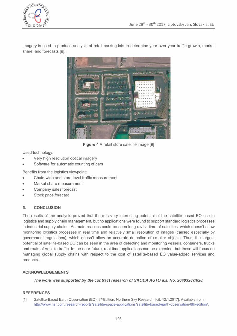
Remote Sensing Metrics (RSM), headquartered in Chicago, United States, provides corporations, investors
and government clients with data focusing on retail parking lot traffic to help measure chain-wide and store-level traffic and market-share, and forecast company sales and stock price. Airbus Defence and Space produces weekly Pléiades imagery of key retail stores in the United States for RSM (see Figure 4). This
Figure 3 Change classification [8]
June 28th - 30th 2017, Liptovsky Jan, Slovakia, EU
108
imagery is used to produce analysis of retail parking lots to determine year-over-year traffic growth, market
share, and forecasts [9].
Figure 4 A retail store satellite image [9]
Used technology:
• Very high resolution optical imagery
• Software for automatic counting of cars
Benefits from the logistics viewpoint:
• Chain-wide and store-level traffic measurement
• Market share measurement
• Company sales forecast
• Stock price forecast
5. CONCLUSION
The results of the analysis proved that there is very interesting potential of the satellite-based EO use in logistics and supply chain management, but no applications were found to support standard logistics processes
in industrial supply chains. As main reasons could be seen long revisit time of satellites, which doesn’t allow monitoring logistics processes in real time and relatively small resolution of images (caused especially by
government regulations), which doesn’t allow an accurate detection of smaller objects. Thus, the largest potential of satellite-based EO can be seen in the area of detecting and monitoring vessels, containers, trucks
and routs of vehicle traffic. In the near future, real time applications can be expected, but these will focus on managing global supply chains with respect to the cost of satellite-based EO value-added services and
products.
ACKNOWLEDGEMENTS
The work was supported by the contract research of SKODA AUTO a.s. No. 26403287/628.
REFERENCES
[1] Satellite-Based Earth Observation (EO), 8th Edition, Northern Sky Research, [cit. 12.1.2017]. Available from: http://www.nsr.com/research-reports/satellite-space-applications/satellite-based-earth-observation-8th-edition/.

June 28th - 30th 2017, Liptovsky Jan, Slovakia, EU
109
[2] Global Satellite-based Earth Observation Market 2016-2020, Technavio, [cit. 12.1.2017]. Available from: http://www.technavio.com/report/global-machine-machine-m2m-and-connected-devices-satellite-based-earth-observation-market.
[3] LAL B., SYLAK-GLASSMAN E.J., MINEIRO M.C., GUPTA N., PRATT L.M., AZARI A.R. Global Trends in Space. Volume 2: Trends by Subsector and Factor that Could Disrupt Them. Institute for Defence Analyses, 2015.
[4] Airbus Defence and Space, [cit. 12.1.2017]. Available from: http://www.intelligence-airbusds.com/.
[5] ImageSat International, [cit. 11.7.2017]. Available from: http://www.imagesatintl.com/solutions-services/maritime-situational-awareness/.
[6] MDA, [cit. 11.7.2017]. Available from: http://mdacorporation.com/geospatial/international/markets/aviation.
[7] MDA, [cit. 11.7.2017]. Available from: http://mdacorporation.com/geospatial/international/markets/defence-and-security/land-intelligence-products.
[8] MDA, RADARSAT-2 Information Products, 2015. Available from: http://mdacorporation.com/docs/default-source/brochures/geospatial-services/radarsat-2-information-products-11502r11.pdf?sfvrsn=6.
[9] Airbus Defence and Space, Pléiades Imagery Supports RS Metrics in Measuring Sales Trends for Wall Street, 2015. Available from: http://www.intelligence-airbusds.com/utils/download?file=r39891_405_casestudy_business_intelligence_rsmetrics_en.pdf.