Embed Size (px)
Citation preview

Bristol Bay SCP: PPOR June 2001 Change 1, February 2013
BRISTOL BAY SUBAREA CONTINGENCY PLAN
POTENTIAL PLACES OF REFUGE
SECTION PART ONE INTRODUCTION ................................................................................................... H-1 A. Purpose and Scope .............................................................................................. H-1 B. How the Document was Developed .................................................................... H-2 C. How to Use the Potential Places of Refuge Section ............................................ H-5 D. Who to Contact for Input .................................................................................... H-5
Tables and Figures Risk Assessment Maps: Figure H-1: Composite Map of All Risk Factors Combined................................... H-7 Figure H-2: Locations of Major Oil Spill Events ..................................................... H-8 Figure H-3: Locations of Spill Response Hubs/Equipment .................................... H-9 Figure H-4 Location of Noncrude Carrier Routes .................................................... H-10 Figure H-5: Logistics................................................................................................ H-11 Figure H-6: Locations of Frequent Fishing Vessel Traffic ...................................... H-12 Figure H-7: Locations of Cruise Ship and Ferry Traffic .......................................... H-13 Figure H-8: Locations of bulk fuel facilities ............................................................ H-14 Table H-1: Site Assessment Matrix Key ................................................................ H-15 Table H-2: Site Assessment Matrix ....................................................................... H-16
PART TWO PPOR INDEX & MAPS ....................................................................................... H-17 PPOR Index Map .................................................................................................... H-17 PPOR Map 1 ........................................................................................................... H-19 PPOR Map 2 ........................................................................................................... H-21 PPOR Map 3 ........................................................................................................... H-23
PART THREE REFERENCES ...................................................................................................... H-25

Bristol Bay SCP: PPOR June 2001 Change 1, February 2013
(This page intentionally blank)

Bristol Bay SCP: PPOR-Part One H-1 June 2001 Change 1, February 2013
POTENTIAL PLACES OF REFUGE: PART ONE – INTRODUCTION A. PURPOSE AND SCOPE This Potential Places of Refuge (PPOR) section supplements information found elsewhere in the Bristol Bay Subarea Contingency Plan for Oil and Hazardous Substances Spills and Releases, commonly referred to as the Bristol Bay Subarea Contingency Plan (SCP). Information about sensitive areas associated with PPOR may be found in the Sensitive Areas - Section D of the SCP. Information about response strategies to protect sensitive areas and areas of public concern associated with PPOR may be found in the Geographic Response Strategies – Section G of the SCP. A “place of refuge” is defined as a location where a vessel needing assistance can be temporarily moved to, and where actions can then be taken to stabilize the vessel, protect human life, reduce a hazard to navigation, and/or protect sensitive natural resources and other uses of the area (e.g., subsistence harvesting, commercial fishing, recreational boating). A place of refuge may include constructed harbors, ports, natural embayments, or offshore waters. This section identifies potential docking, anchoring, and mooring locations that may be selected as Places of Refuge in the Bristol Bay Subarea. Actual designation of a Place of Refuge will always be an incident-specific decision made by the U.S. Coast Guard Captain of the Port (COTP) for Bristol Bay. The Bristol Bay Subarea has thousands of miles of environmentally sensitive coastline. In addition to sensitive shoreline habitats such as marshes, sheltered tidal flats, and exposed tidal flats, Bristol Bay supports a number of sensitive biological resources including birds, fish and shellfish, and marine mammals. The local communities are heavily reliant on marine resources for their livelihood and subsistence. Because of this unique relationship with the marine environment, much of the coast is utilized for subsistence activities and is extremely sensitive to the impacts of marine commerce, especially oil spills. Additional information about identification of sensitive areas and resources may be found in Section D of the SCP. Additional information about protection of sensitive areas may be found in Section G of the SCP. In the Bristol Bay Subarea there are extensive commercial fisheries. Much of the marine commerce focuses on the support of this industry. The remaining marine commerce includes the resupplying of the communities and industry during the ice-free period of the summer and fall. With climate change precipitating the ongoing reduction in sea ice and the subsequent expansion of the operating season, it is likely that shipping and industrial activities will increase throughout the Arctic and subarctic areas. This activity will see a corresponding rise in marine commerce utilizing a variety of different types of vessels. Fuel barges, freighters, container ships, drilling ships, tankers and cruise ships operating in, and transiting through Bristol Bay may become more routine. Bristol Bay is a unique operating environment, with limited infrastructure, extreme weather and few protected anchorages. Shallow waters extend for miles offshore in the northern part of the subarea, while deep, narrow fjords are common on the southern side of the Alaska Peninsula. These considerations affect the ability to accommodate stricken vessels of any size in these waters. The protection offered in most of the sites listed is limited and available only under certain circumstances outlined in the plans. In developing this section consideration was given to typical anchorage sites near communities. These are well-known areas that have access to some of the limited infrastructure in the area that may affect repairs and assist in the response. It is widely acknowledged that there is no perfect docking, mooring or anchoring site for all vessels in all situations. A vessel’s length and draft are major determining factors when considering a site for

Bristol Bay SCP: PPOR-Part One H-2 June 2001 Change 1, February 2013
refuge. Deep draft vessels, such as oil tankers and cruise ships, cannot be taken to certain locations. It is widely acknowledged that there is no perfect docking, mooring or anchoring, site for all vessels in all situations. A vessel’s length and draft are major determining factors when considering a site for refuge. Deep draft vessels, such as oil tankers and cruise ships, cannot be taken to certain locations. Some ports and bays may have shallow approaches and deep draft ships cannot enter these locations. Shallower draft vessels, such as fishing vessels and supply vessels may be able to utilize these ports. For the purposes of this section, vessels have been divided into four categories: Deep Draft II Vessels are vessels with lengths up to and greater than 1000 feet and
typically have drafts of 40-60 feet. The predominant deep draft vessels that may operate in the Bristol Bay subarea are container ships and tankers that are designed to the New Panamax dimensions.
Deep Draft I Vessels are vessels with lengths up to and greater than 1000 feet and typically have drafts of 20-40 feet. The predominant deep draft vessels of this type that may operate in the Bristol Bay subarea are container ships and tankers.
Light Draft Vessels are vessels up to 450 feet in length and have drafts to 20 feet. Freighters, catcher processors, ferries and ocean going tugs are the most common light draft vessels operating in Bristol Bay. Shallow Draft Vessels are less than 300 gross tons and have drafts less than 15 feet.
The information in this section may be used for a vessel of any size that has suffered an incident, which creates a need for a temporary place of safe refuge, but it is focused on deep draft and light draft size vessels. Shallow draft sites were identified as assets for responding to PPOR incidents.
B. HOW THE PPOR DOCUMENTS WERE DEVELOPED This section was developed in 2012 by a Work Group of interested and knowledgeable stakeholders in keeping with the Alaska Regional Response Team's "Guidelines for Places of Refuge Decision-Making," (Alaska Federal/State Preparedness Plan for Response to Oil and Hazardous Substance Discharges/Releases, Annex O). The Work Group arrived at a consensus on the potential places of refuge and submitted this document to the Subarea Committee for approval and inclusion in the Bristol Bay Subarea Contingency Plan. The Work Group participants represented the following organizations:
Alaska Department of Environmental Conservation Alaska Department of Natural Resources Alaska Department of Fish and Game Alaska Marine Pilots Association Vitus Marine Bristol Bay Native Corporation The City of Dillingham

Bristol Bay SCP: PPOR-Part One H-3 June 2001 Change 1, February 2013
U.S. Coast Guard U.S. Department of the Interior – Offices of Environmental Policy and Compliance, Fish and Wildlife Service, and National Park Service U.S. Environmental Protection Agency U.S. Department of Commerce
NOAA National Marine Fisheries Service
First Step: Risk Identification The first step of the PPOR process identified 14 candidate sites (anchorages, moorings, docks/ piers) within the Bristol Bay subarea. The Workgroup began by researching available information to determine major risk factors. Maps were developed, depicting the following risk and logistical information:
• A composite map of all risk factors combined (Figure H-1); • Locations of major oil spill events (Figure H-2) • Locations of spill response hubs/equipment (Figure H-3); • Location of noncrude carrier routes (Figure H-4); • Locations of Logistical Support (Figure H-5); • Locations of frequent fishing vessel traffic (Figure H-6); • Locations of cruise ship and ferry traffic (Figure H-7); • Locations of bulk fuel facilities (Figure H-8)
Second Step: Feasibility The second step led to the identification of 14 PPOR sites within the Bristol Bay subarea, in addition to existing infrastructure. A site assessment matrix (Table H-2) and key (Table H-1) were developed. The matrix consists of identified sites in each row with information about risk factors and site selection criteria in the columns. The information presented for each site includes:
• PPOR identification; • Response Zone #; • Type of Berth; • Location Name; • Latitude; • Longitude; • Maximum Vessel Depth • Anchoring Swing Room or Dock Face in feet; • Depth at dock face: • Depth at anchorage; • Bottom Type; • Exposure to predominant wind and sea conditions; • Conflicting uses; • Ability to boom; • GRS in the area; • Sensitive Resources; • Distance to population centers; and

Bristol Bay SCP: PPOR-Part One H-4 June 2001 Change 1, February 2013
• Distance to alternate PPOR. The PPOR identification method begins with a “DII”, “DI” “L” or “S” which indicates the appropriate size vessel for the site. Following the letter is a number which indicates the response zone in which the site is located. This is then followed by a number which is a unique site identifier with no importance attached to the magnitude of the number. The site assessment matrix contains potentially suitable emergency anchorage, docking and moorage locations based on operational factors such as water depth, swing room, exposure/protection, and navigational approach. Sites are grouped by the individual response zones and then by the maximum vessel size category suitable for the site. Third Step: Factors to Consider Step 3 identified specific factors that should be considered as part of the site assessment process. These factors include:
• Distance from population and logistics centers; • Proximity to environmentally sensitive areas, wildlife resources, threatened or
endangered species or habitats, and/or historic properties; • Uses, such as fisheries, subsistence use, tourism and recreational use, and the location of
public or private facilities; • Response factors such as booming feasibility and the proximity to existing Geographic
Response Strategy (GRS) sites; and • The distance from the closest alternative PPOR.
Fourth Step: Review and Comment Step 4 afforded the work group and stakeholders in the area the opportunity to review and comment on the draft documents. In this review, the workgroup ensured that information critical to their area of expertise is included.

Bristol Bay SCP: PPOR-Part One H-5 June 2001 Change 1, February 2013
C. HOW TO USE THE POTENTIAL PLACES OF REFUGE SECTION
The "Guidelines for Places of Refuge Decision-Making" (Annex O of the Unified Plan) will be used for places of refuge decision-making in the Bristol Bay subarea. http://dec.alaska.gov/spar/perp/plans/uc/Annex%20O%20(Jan%2010).pdf Part Two of this document contains site-specific information for the PPOR in the Bristol Bay subarea. An index map at the beginning of this section shows the location of the PPOR maps. Each PPOR map consists of two parts: 1) a map page showing a locator map, and detailed nautical charts; and 2) a table page providing site information and local site conditions. All geographic data was collected using Mercator Projection, North American Datum 1983.
D. WHO TO CONTACT FOR INPUT Comments and recommendations on these PPOR are welcomed. Please send your comments to either of the following agencies:
Alaska Department of Environmental Conservation Prevention and Emergency Response Program
555 Cordova Street Anchorage, AK 99501
United States Coast Guard Captain of the Port for Western Alaska
510 L Street-Suite 100 Anchorage, Alaska 99501-1946

Bristol Bay SCP: PPOR-Part One H-6 June 2001 Change 1, February 2013
(This page intentionally blank)

Figure H-1: Composite Map of All Risk Factors Combined
Bristol Bay SCP: PPOR-Part One H-7 June 2001 Change 1, February 2013

Bristol Bay SCP: PPOR-Part One H-8 June 2001 Change 1, February 2013
Figure H-2: Locations of Major Oil Spill Events

Figure H-3: Locations of Response Equipment
Bristol Bay SCP: PPOR-Part One H-9 June 2001 Change 1, February 2013

Figure H-4: Locations of Noncrude Carrier Routes
Bristol Bay SCP: PPOR-Part One H-10 June 2001 Change 1, February 2013

Bristol Bay SCP: PPOR-Part One H-11 June 2001 Change 1, February 2013
Figure H-5: Logistics

Figure H-6: Locations of Frequent Fishing Vessel Traffic
Bristol Bay SCP: PPOR-Part One H-12 June 2001 Change 1, February 2013

Figure H-7: Locations of Cruise Ship and Ferry Traffic
Bristol Bay SCP: PPOR-Part One H-13 June 2001 Change 1, February 2013

Figure H-8: Locations of Bulk Fuel Storage
Bristol Bay SCP: PPOR-Part One H-14 June 2001 Change 1, February 2013

Table H-1: Site Assessment Matrix Key
Bristol Bay SCP: PPOR-Part One H-15 June 2001 Change 1, February 2013

Bristol Bay SCP: PPOR-Part One H-16 June 2001 Change 1, February 2013
Table H-2: Site Assessment Matrix
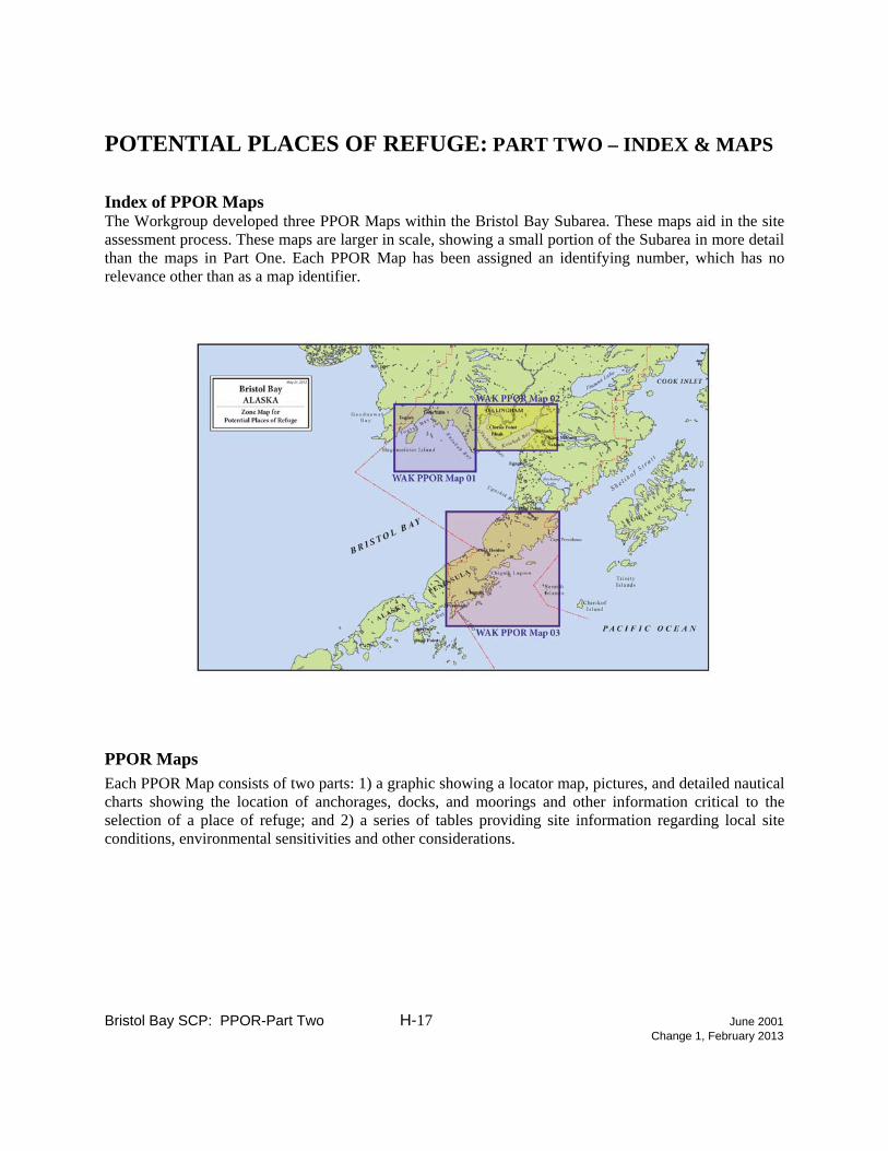
POTENTIAL PLACES OF REFUGE: PART TWO – INDEX & MAPS Index of PPOR Maps The Workgroup developed three PPOR Maps within the Bristol Bay Subarea. These maps aid in the site assessment process. These maps are larger in scale, showing a small portion of the Subarea in more detail than the maps in Part One. Each PPOR Map has been assigned an identifying number, which has no relevance other than as a map identifier. PPOR Maps Each PPOR Map consists of two parts: 1) a graphic showing a locator map, pictures, and detailed nautical charts showing the location of anchorages, docks, and moorings and other information critical to the selection of a place of refuge; and 2) a series of tables providing site information regarding local site conditions, environmental sensitivities and other considerations.
Bristol Bay SCP: PPOR-Part Two H-17 June 2001 Change 1, February 2013

Bristol Bay SCP: PPOR-Part Two H-18 June 2001 Change 1, February 2013
(This page intentionally blank)

Bristol Bay SCP: PPOR-Part Two H-19 June 2001 Change 1, February 2013

Bristol Bay SCP: PPOR-Part Two H-20 June 2001 Change 1, February 2013
Bristol Bay SCP: PPOR-Part Two H-21 June 2001 Change 1, February 2013

Bristol Bay SCP: PPOR-Part Two H-22 June 2001 Change 1, February 2013

Bristol Bay SCP: PPOR-Part Two H-23 June 2001 Change 1, February 2013

Bristol Bay SCP: PPOR-Part Two H-24 June 2001 Change 1, February 2013

Bristol Bay SCP: PPOR-Part Three H-25 June 2001 Change 1, February 2013
POTENTIAL PLACES OF REFUGE: PART THREE – REFERENCES Alaska Regional Response Team. October 2004. Alaska Federal/State Preparedness Plan for Response to Oil and Hazardous Substance Discharges/Releases, Annex O, Guidelines for Places of Refuge Decision-Making. Dept of Commerce - National Oceanic & Atmospheric Administration (NOAA), National Ocean Survey can provide detailed hydrographic charts of PPOR locations upon request. Contact Dave Neander, [email protected], (206) 526-6949, NOAA/ORR, 7600 Sand Point Way, NE, Seattle, WA 98115. Useful Websites The "Guidelines for Places of Refuge Decision-Making" Annex O of the Unified Plan http://dec.alaska.gov/spar/perp/plans/uc/Annex%20O%20(Jan%2010).pdf) Alaska Dept. of Environmental Conservation, Bristol Bay GRS Information http://www.dec.state.ak.us/spar/perp/grs/bb/home.htm Alaska Dept. of Environmental Conservation, Bristol Bay Subarea Contingency Plan. http://www.dec.state.ak.us/spar/perp/plans/scp_bb.htm Alaska Dept. of Natural Resources. Bristol Bay Public Access Atlas. http://www.dnr.state.ak.us/mlw/planning/easmtatlas/ Alaska Dept. of Natural Resources, Bristol Bay Subarea maps including, general maps, land use and management maps, biologically sensitive area maps, most environmentally sensitive area maps, environmentally sensitive index maps, and geographic response strategies. http://www.asgdc.state.ak.us/maps/cplans/subareas.html#bristol U.S Bureau of Land Management. Alaska Land Information System. http://www.ak.blm.gov/alis/

Bristol Bay SCP: PPOR-Part Three H-26 June 2001 Change 1, February 2013
(This page intentionally blank)