Embed Size (px)
Citation preview
Ground based dual-polarization radars provide physical insight into the
development and interpretation of spaceborne precipitation measurements
POTENTIAL ROLE OF DUAL- POLARIZATION RADAR IN THE VALIDATION OF
SATELLITE PRECIPITATION MEASUREMENTSRationale and Opportunities
BY V. CHANDRASEKAR, ARTHUR HOU, ERIC SMITH, V. N. BRINGI, S. A. RUTLEDGE, E. GORGUCCI, W. A. PETERSEN,
AND GAIL SKOFRONICK JACKSON
R eliable global quantitative precipita-
tion measurement is critically important
for a variety of applications, including flood
forecasting, numerical weather prediction, understanding
the evolution of hurricanes and severe storms, and tracking
of long-term trends in global precipitation and water supply. When
combined with comprehensive ground validation and calibration, satellite
observations offer practical prospects for acquiring accurate and global datasets
especially over oceans and remote regions. Since the advent of satellite sensing of clouds
and precipitation there has been much progress in terms of instrumentation and algorithm
development. The Tropical Rainfall Measuring Mission (TRMM), launched in 1997, represents an
advanced active and passive remote sensing system to measure precipitation. Each precipitation
satellite mission requires thorough ground validation to test instrument and algorithm performance.
With the success of the TRMM and the plans for TRMM’s successor mission, the Global Precipitation
Measurement mission (GPM), the current era represents
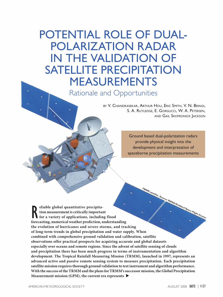
TRMM satellite. Source: NASA/Goddard Space Flight Center
1127AUGUST 2008AMERICAN METEOROLOGICAL SOCIETY |
the “golden age” of microwave precipitation remote
sensing (National Research Council 2006, 2007).
Yet, even with the success of TRMM, more com-
plete coverage is needed, both spatially and tempo-
rally. TRMM only samples tropical precipitation (±35°
latitude) and has an orbit period of about 92 min with
an approximate repeat cycle of 40 days (Chang et al.
1999). Additional coverage is needed for short-term
finescale applications such as hydrology, and for im-
proving and validating GCM models. The Committee
on Earth Observation Satellites (CEOS), the interna-
tional coordinating body for earth observing satellite
systems (available online at www.ceos.org), declared
precipitation to be an important measurement and
they identify GPM as a prototype of the Global Earth
Observation System of Systems (GEOSS).
The GPM mission is an international satellite
mission to provide accurate precipitation measure-
ments around the globe every 2 to 4 h (available
online at http://gpm.gsfc.nasa.gov). The GPM mission
concept is centered on the deployment of a Core
Observatory satellite with an active dual-frequency
(Ka/Ku band) precipitation radar and a passive
GPM Microwave Imager (GMI) with wideband
(10–183 GHz) capabilities (Shimizu et al. 2006). The
core satellite (±65° latitude) will serve as a precipita-
tion physics observatory and will provide the calibra-
tion standard for a global constellation of dedicated
and operational passive microwave sensors. The
baseline GPM constellation is envisioned to com-
prise conically scanning radiometers such as GMI,
Global Change Observing Mission (GCOM)-W, and
Special Sensor Microwave Imager/Sounder (SSMIS),
supplemented by cross-track sounders, such as
Advanced Technology Microwave Sounder (ATMS)
and Microwave Humidity Sensor (MHS) over land.
GPM is currently a partnership between the National
Aeronautics and Space Administration (NASA) and
the Japan Aerospace Exploration Agency (JAXA),
with opportunities for participation of additional
partners via constellation satellites. The anticipated
launch date of the GPM Core spacecraft is expected
to occur in 2013.
GPM is a science mission with integrated ap-
plications goals for advancing the knowledge of
the global water/energy cycle variability as well
as improving weather, climate, and hydrological
prediction capabilities through more accurate and
frequent measurements of global precipitation. The
dual-frequency precipitation radar (DPR) aboard
the GPM core satellite is expected to improve our
knowledge of precipitation processes relative to the
single-frequency radar used in TRMM by providing
greater dynamic range, more detailed information
on microphysics, and better accuracies in rainfall
and liquid water content retrievals. The DPR will
be able to provide information on rain and snow
distributions over a wide range of precipitation
intensities (from ~0.2 to about 110 mm h–1). This
information will not only give us insight into micro-
physical processes but also provide bulk properties
of the precipitation, such as water f lux (rain rate)
and water content. The dual-frequency returns will
also allow us to distinguish regions of liquid, frozen,
and mixed-phase precipitation. Overall, the com-
bination of Ka and Ku bands should significantly
improve the detection thresholds for light rain and
snow relative to TRMM. The improved accuracy and
more detailed microphysical information from the
dual-wavelength radar can also be used to constrain
the cloud model database to be used in simultane-
ous precipitation retrievals from the brightness
temperature measurements by the multichannel
radiometer on the GPM Core. These radiometric
improvements should be transferable to the constel-
lation radiometers where simultaneous radar data
are not available.
Validation is an integral part of all satellite pre-
cipitation missions. The process of validation is a
cross-cutting effort covering many areas all the way
from sensor development to ending with the end us-
ers products. Ground validation helps to character-
ize errors, quantify measurement uncertainty, and,
most importantly, provide insight into the physical
and statistical basis of the retrieval algorithms. The
GPM validation falls in the general class of valida-
tion and integration of information from a variety of
spaceborne observing platforms with ground-based
measurements and data assimilation efforts. For
TRMM, the validation activity included elements
AFFILIATIONS: CHANDRASEKAR, BRINGI, AND RUTLEDGE—Colorado State University, Fort Collins, Colorado; HOU, SMITH, AND SKOFRONICK JACKSON—NASA Goddard Space Flight Center, Greenbelt, Maryland; GORGUCCI—Istituto di Scienze dell’ Atmosfera e del Clima (CNR), Rome, Italy; PETERSEN—NASA Marshall Space Flight Center, Huntsville, AlabamaCORRESPONDING AUTHOR: V. Chandrasekar, Colorado State University, 1373 Campus Delivery, Fort Collins, CO 80523-1373E-mail: [email protected]
The abstract for this article can be found in this issue, following the table of contents.DOI:10.1175/2008BAMS2177.1
In final form 15 February 2008©2008 American Meteorological Society
1128 AUGUST 2008|
such as pointwise validation of spaceborne radar
measurements, statistical validation of the precipi-
tation products, and validation for understanding
precipitation processes. For GPM, the traditional ap-
proaches are planned with the addition of validation
sites designed specifically to 1) perform statistical
validation of retrieved satellite surface precipitation
products, 2) investigate precipitation processes, and
3) validate integrated hydrology applications.
Dual-polarization weather radar is a very powerful
validation tool that can be used to address a number
of important questions that arise in the validation
process, especially those associated with precipitation
microphysics and algorithm development. Beginning
with the early introduction of circular polarization
measurements by McCormick and Hendry (1975) and
the subsequent advancement of linear polarization
measurements by Seliga and Bringi (1976), polariza-
tion diversity radars have consistently advanced all
three areas of interest for cross validation of space-
borne measurements, namely, the understanding of
precipitation processes, calibration, and quantitative
precipitation estimation (QPE). The introduction of
differential phase measurements advanced the QPE
applications (Seliga and Bringi 1978; Sachidananda
and Zrnic 1987; Chandrasekar et al. 1990), whereas
the microphysical characterization has advanced
significantly to the level of producing hydrometeor
classification products (Straka et al. 2000; Liu and
Chandrasekar 1998, 2000; Vivekanandan et al. 1999).
Dual-polarization radar measurements were also
used to advance the radar calibration for quantitative
applications, using the self-consistency principle of
the polarization diversity measurements (Gorgucci
et al. 1992; Scarchilli et al. 1996). Thus, the dual-
polarization measurements have played a significant
role in several areas of importance to cross validation
of satellite observation of precipitation.
The following describes the various aspects of
the dual-polarization weather radar specifically
in the context of validating spaceborne precipita-
tion estimates. This paper is organized as follows:
the next section provides brief background on the
dual-polarization weather radars, along with the
discussion of various types of dual-polarization
radar measurements. The different implementa-
tion of dual-polarization radars involves different
technologies and they are also summarized. In the
section “Application of dual-polarization radar to
rainfall microphysical retrievals,” the applications
of dual-polarization radars for rainfall microphysi-
cal research is reviewed, especially in the context
of spaceborne application. A brief background of
the TRMM program space-based measurement of
precipitation is discussed in the section “Progress on
validation of TRMM precipitation measurement with
dual-polarization radars” along with the advance-
ment made during the TRMM era in cross validation
of satellite measurements. Potential applications of
dual-polarimetric radar in the GPM era are sum-
marized in section 5.
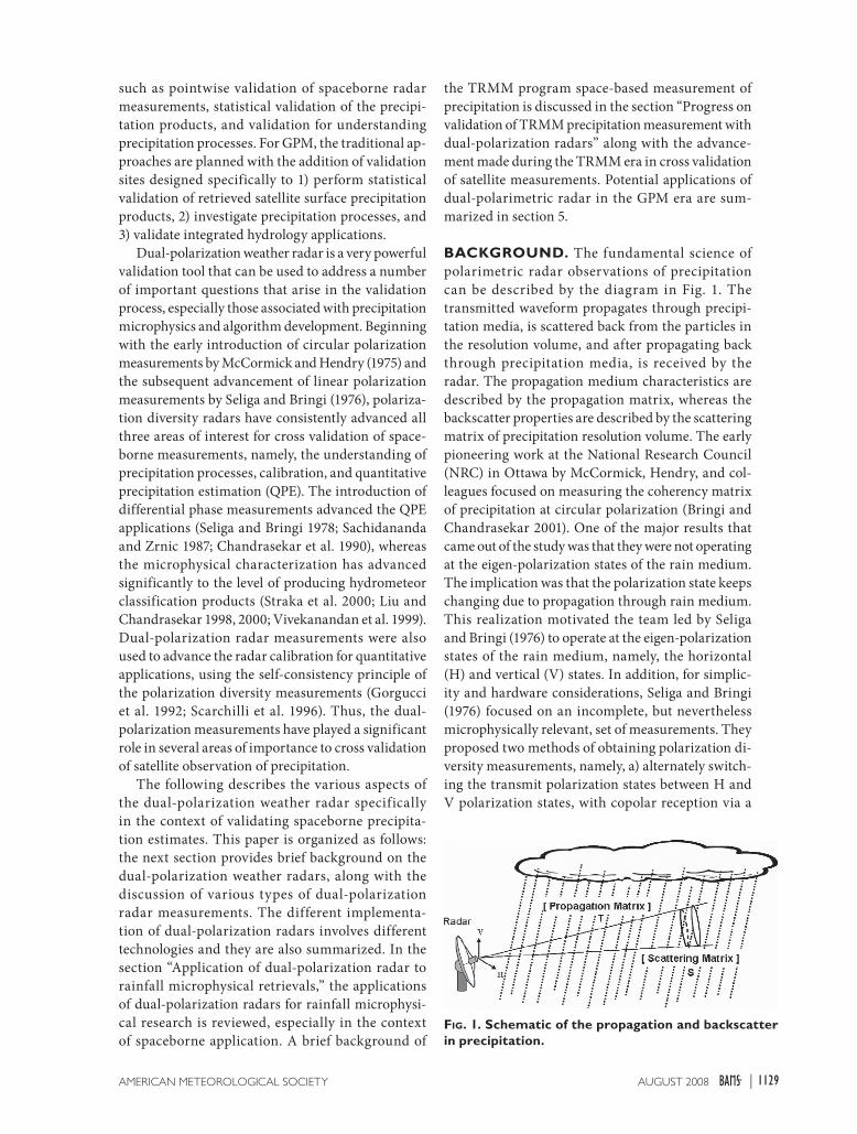
BACKGROUND. The fundamental science of
polarimetric radar observations of precipitation
can be described by the diagram in Fig. 1. The
transmitted waveform propagates through precipi-
tation media, is scattered back from the particles in
the resolution volume, and after propagating back
through precipitation media, is received by the
radar. The propagation medium characteristics are
described by the propagation matrix, whereas the
backscatter properties are described by the scattering
matrix of precipitation resolution volume. The early
pioneering work at the National Research Council
(NRC) in Ottawa by McCormick, Hendry, and col-
leagues focused on measuring the coherency matrix
of precipitation at circular polarization (Bringi and
Chandrasekar 2001). One of the major results that
came out of the study was that they were not operating
at the eigen-polarization states of the rain medium.
The implication was that the polarization state keeps
changing due to propagation through rain medium.
This realization motivated the team led by Seliga
and Bringi (1976) to operate at the eigen-polarization
states of the rain medium, namely, the horizontal
(H) and vertical (V) states. In addition, for simplic-
ity and hardware considerations, Seliga and Bringi
(1976) focused on an incomplete, but nevertheless
microphysically relevant, set of measurements. They
proposed two methods of obtaining polarization di-
versity measurements, namely, a) alternately switch-
ing the transmit polarization states between H and
V polarization states, with copolar reception via a
FIG. 1. Schematic of the propagation and backscatter in precipitation.
1129AUGUST 2008AMERICAN METEOROLOGICAL SOCIETY |
single receiver, and b) simultaneous transmission and
reception (STAR) mode using dual-channel receivers.
The late 1970s were prior to the digital revolution,
and the alternate switching of polarization along
with copolar signal reception with a single receiver
was much cheaper to implement compared to the
two-receiver mode of implementation. Subsequently,
many research radar installations upgraded their
radars to dual-polarization capability, including the
University of Chicago–Illinois State Water Survey
(CHILL) radar, National Center for Atmospheric
Research (NCAR) CP-2, and the Chilbolton radar.
Most of the activities in the United States were con-
centrated on making detailed copolar and cross-polar
measurements and interpreting these data by devel-
oping simplified microphysical models.
In the meantime, in the late 1980s the research
team at the German Aerospace Research Estab-
lishment (DLR) embarked on a fairly aggressive
program to develop a polarization diversity radar
to make measurements at arbitrary polarization
states (Schroth et al. 1988). They also installed a
unique polarization switch and polarizer such that
the receive polarization states could be controlled
independent of the transmit polarization states. By
then several teams, including the DLR and Colorado
State University–CHILL (CSU–CHILL), started
pursuing the complete set of measurements from
linear polarization states.
Though the initial Next Generation Weather
Radars (NEXR AD) were not dual polarized,
polarization research initiated at the National
Severe Storms Laboratory (NSSL), along with the
overwhelming results from other radar installations
mentioned above, led to the deployment of a proto-
type dual-polarization radar for the U.S. National
Weather Service (Doviak et al. 2000). Similarly,
several European countries have initiated deploy-
ment of dual-polarization radars for operational
applications, indicating the maturity of the science
and applications (Parent et al. 2005). Commercial
entities, including several stations in the broadcast
meteorological sector, have also recognized the
operational QPE benefits of dual-polarimetric radar
and have begun upgrade to C-band dual-polarimetry
[e.g., the joint University of Alabama at Huntsville
(UAH)–WHNT-TV Advanced Radar for Meteoro-
logical and Operational Research (ARMOR) radar;
Petersen et al. 2007]. Thus, dual-polarization radars
have come a long way from early research to opera-
tional application. The Joint Polarization Experiment
(JPOLE; Ryzhkov et al. 2005) evaluated the opera-
tional applications of dual-polarization radar from
a weather service perspective and the potential
demonstrated by the various observations of dual
polarization since the early 1980s have resulted in a
decision by the National Weather Service to upgrade
the Weather Service radars [Weather Surveillance
Radar-1988 Doppler (WSR-88D)] to dual polarization
(available online at www.roc.noaa.gov).
In a conventional single-polarization radar the
reflectivity factor is related to the backscatter cross
section of the individual precipitation particles
through the particle size distribution. The various
parameters measured from the dual-polarization
radars are essentially the various elements of the
dual-polarization covariance matrix (DPCV) of pre-
cipitation (Bringi and Chandrasekar 2001). If a radar
can measure all elements of the dual-polarization
covariance matrix, then it is termed a fully polari-
metric radar. Many dual-polarization radars measure
only a subset of the elements of the dual-polarization
covariance matrix. Most of the definitions of the
various dual-polarization measurements are avail-
able in various research articles and textbooks (e.g.,
Bringi and Chandrasekar 2001). The equivalent
radar reflectivity factor at each polarization is given
by the diagonal elements of the covariance matrix,
proportional to the volumetric radar cross section.
An extension of this ref lectivity measurement to
dual polarization with the distinction of radar cross
section of particles and reflectivities between hori-
zontal and vertical polarization states results in the
differential reflectivity (Zdr
). Here, Zdr
is defined as
the ratio of reflectivities at horizontal and vertical
polarization:
(1)
where Zh, Z
v are the radar reflectivity factors mea-
sured at horizontal and vertical polarization. The
copolar correlation coefficient is defined as the
correlation between the radar-received signals at
horizontal and vertical polarization; it is a complex
number possessing a magnitude from zero to one and
is denoted by the symbol ρco
to indicate the copolar
correlation coefficient.
In addition to measuring reflectivities at the same
polarization state transmitted by the radar, the sys-
tems can be configured to measure the received power
at the polarization state orthogonal to the transmitted
polarization state. This was routinely accomplished
in circular polarization operation (McCormick and
Hendry 1975), but not common with linear polariza-
tion states. When the cross-polar power is measured
1130 AUGUST 2008|
at the linear polarization state, then it is converted
to an equivalent reflectivity factor and the ratio of
copolar to crosspolar reflectivity is termed as linear
depolarization ratio (LDR). Here, Zh, Z
dr, and LDR are
real (power) measurements, whereas ρco
is complex,
associated with a magnitude and a phase. As the elec-
tromagnetic wave from the radar propagates through
precipitation, then the dual-polarization signals are
modified due to propagation effects, such as dif-
ferential attenuation and differential phase between
the H and V polarization states. At radar frequencies
where the attenuation is negligible such as S band, the
main impact of propagation through precipitation is
the differential phase. In the presence of propagation,
the phase of ρco
is modified as
Arg[ρco
] = ϕdp
+ δhv
, (2)
where φdp
is the differential phase due to propagation,
and δhv
is the differential phase due to backscatter.
The differential propagation phase is proportional to
the water content along a rain path and is one of the
important parameters measured by dual-polarization
radar (Seliga and Bringi 1978; Jameson 1985).
The term dual-polarization radar does not
uniquely refer to a specific radar configuration or a
set of measurements. Several configurations of dual-
polarization radars are available depending on the
measurement goals and choice of polarization states.
The covariance matrix forms a complete set of mea-
surements and several research radars are configured
for this measurement. In the early 1980s a number of
single-polarized research radars were modified for
limited dual-polarization measurements in the linear
horizontal/vertical polarization states, for measuring
differential reflectivity and later differential phase.
These measurements involved only copolar signals,
and the system requirements were not very stringent
(Wang and Chandrasekar 2006) and significant
practical results (such as rain-rate estimation and hail
detection) were obtained fairly quickly.
The most general dual-polarization radar can be
described as the system that has both polarization
agility on transmit and polarization diversity on
receive mode. Polarization agility refers to the ability
to change the transmitted polarization state between
any two orthogonal states on a pulse-to-pulse basis,
whereas polarization diversity refers to the ability to
simultaneously receive two orthogonal polarization
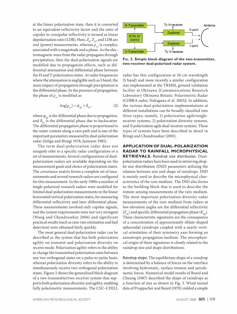
states. Figure 2 shows the generalized block diagram
of a two-transmitter/two-receiver system that sup-
ports both polarization diversity and agility, enabling
fully polarimetric measurements. The CSU–CHILL
radar has this configuration at 10-cm wavelength
(S band) and more recently a similar configuration
was implemented at the TRMM, ground validation
facility at Okinawa [Communications Research
Laboratory Okinawa Bistatic Polarimetric Radar
(COBRA radar; Nakagawa et al. 2003)]. In addition,
the various dual-polarization implementations at
different installations can be broadly classified into
three types, namely, 1) polarization agile/single-
receiver systems, 2) polarization diversity systems,
and 3) polarization agile dual-receiver systems. These
types of systems have been described in detail in
Bringi and Chandrasekar (2001).
APPLICATION OF DUAL-POLARIZATION RADAR TO RAINFALL MICROPHYSICAL RETRIEVALS. Raindrop size distribution. Dual-
polarization radars have been used in retrieving drop-
let size distribution (DSD) parameters utilizing the
relation between size and shape of raindrops. DSD
is mainly used to describe the microphysical char-
acteristics of the rain medium. The DSD also forms
as the building block that is used to describe the
remote sensing measurements of the rain medium.
The most important polarization diversity radar
measurements of the rain medium from radars at
low-elevation angles are the differential reflectivity
(Zdr
) and specific differential propagation phase (Kdp
).
These characteristic signatures are the consequence
of a concentration of approximately oblate-shaped
spheroidal raindrops coupled with a nearly verti-
cal orientation of their symmetry axes forming an
anisotropic propagation medium. The microphysi-
cal origin of these signatures is closely related to the
raindrop size and shape distributions.
Raindrop shape. The equilibrium shape of a raindrop
is determined by a balance of forces on the interface
involving hydrostatic, surface tension and aerody-
namic forces. Numerical model results of Beard and
Chuang (1987) described the shape of raindrops as
a function of size as shown in Fig. 3. Wind tunnel
data of Pruppacher and Beard (1970) yielded a simple
FIG. 2. Simple block diagram of the two-transmitter, two-receiver dual-polarized radar system.
1131AUGUST 2008AMERICAN METEOROLOGICAL SOCIETY |
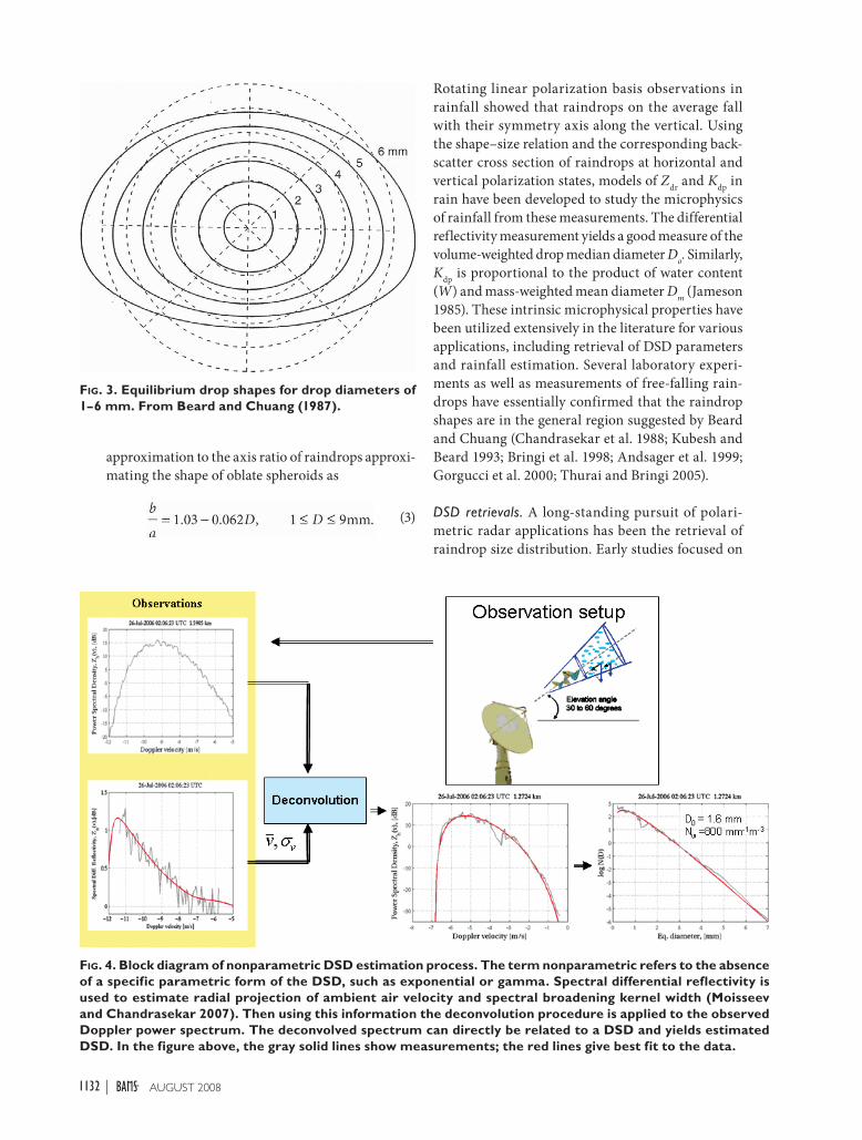
approximation to the axis ratio of raindrops approxi-
mating the shape of oblate spheroids as
(3)
Rotating linear polarization basis observations in
rainfall showed that raindrops on the average fall
with their symmetry axis along the vertical. Using
the shape–size relation and the corresponding back-
scatter cross section of raindrops at horizontal and
vertical polarization states, models of Zdr
and Kdp
in
rain have been developed to study the microphysics
of rainfall from these measurements. The differential
reflectivity measurement yields a good measure of the
volume-weighted drop median diameter Do. Similarly,
Kdp
is proportional to the product of water content
(W) and mass-weighted mean diameter Dm
(Jameson
1985). These intrinsic microphysical properties have
been utilized extensively in the literature for various
applications, including retrieval of DSD parameters
and rainfall estimation. Several laboratory experi-
ments as well as measurements of free-falling rain-
drops have essentially confirmed that the raindrop
shapes are in the general region suggested by Beard
and Chuang (Chandrasekar et al. 1988; Kubesh and
Beard 1993; Bringi et al. 1998; Andsager et al. 1999;
Gorgucci et al. 2000; Thurai and Bringi 2005).
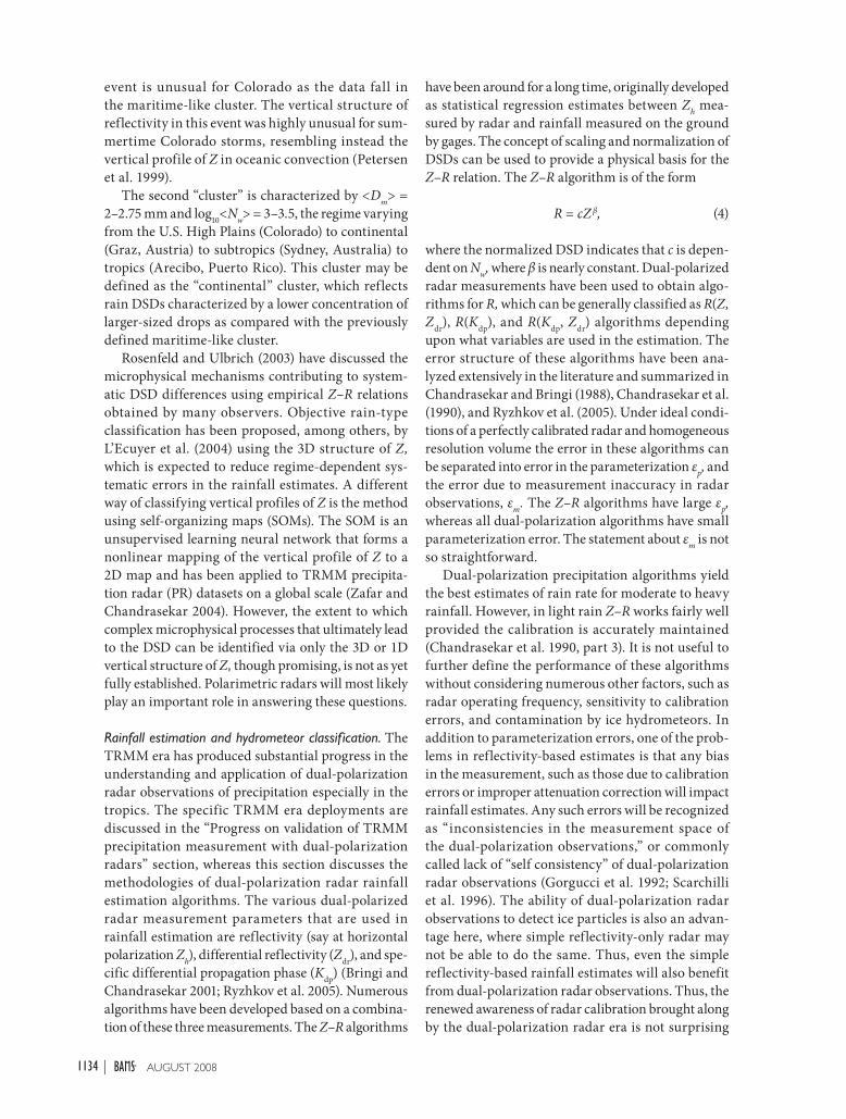
DSD retrievals. A long-standing pursuit of polari-
metric radar applications has been the retrieval of
raindrop size distribution. Early studies focused on
FIG. 3. Equilibrium drop shapes for drop diameters of 1–6 mm. From Beard and Chuang (1987).
FIG. 4. Block diagram of nonparametric DSD estimation process. The term nonparametric refers to the absence of a specific parametric form of the DSD, such as exponential or gamma. Spectral differential reflectivity is used to estimate radial projection of ambient air velocity and spectral broadening kernel width (Moisseev and Chandrasekar 2007). Then using this information the deconvolution procedure is applied to the observed Doppler power spectrum. The deconvolved spectrum can directly be related to a DSD and yields estimated DSD. In the figure above, the gray solid lines show measurements; the red lines give best fit to the data.
1132 AUGUST 2008|

the estimates of drop median diameter Do or the
mass-weighted mean diameter Dm
. Fairly simple
power-law-based retrievals have been developed in
the literature both based on theoretical considerations
as well as empirical deductions (Seliga and Bringi
1976; Aydin et al. 1987; Goddard and Cherry 1984).
Therefore dual-polarization measurements provide
fairly simple retrievals of DSD parameters. Gorgucci
et al. (2001, 2002) developed algorithms for retrieving
rain rate (R) as well as the parameters of a gamma
DSD, namely, Do, N
w, and μ using the effective shape
concept in combination with the measurement pair
(Zh, Z
dr). The functional relationship between Z
dr and
Do is developed from the underlying microphysical
relation between the mean axis ratio of raindrops
and their size.
Once Do is retrieved, then the other parameters of
the DSD can be retrieved, such as the intercept of the
normalized form of a gamma distribution (Gorgucci
et al. 2002). The statistics of the parameter sets Do,
Nw are important in the development of algorithms.
Bringi et al. (2003) used the DSD retrieval method
to scale the process to world-wide application over
different climatic regimes. While the above are
parametric retrievals, nonparametric retrievals of
DSDs are also possible combining the advantages of
a Doppler and polarimetric radar as demonstrated
by Moisseev and Chandrasekar (2007). Figure 4
shows the nonparametric DSD retrieval from dual-
polarization spectral analysis.
The variability of the DSD across different cli-
matic regimes can be demonstrated by examining
the variability of mean <Nw> versus mean <D
m>,
where angle brackets denote averages. For example,
Fig. 5a shows such data retrieved from disdrometer
measurements as well as from polarimetric radar
data for stratiform rain. A large extent of the data
for Fig. 5 came from the globally diverse ground
validation observations of the TRMM program. For
stratiform rain there appears to be a clear inverse
relation between log10
(<Nw>) and <D
m>; in fact, it is
quite remarkable that a straight-line fit results from
the composite disdrometer and radar retrievals, these
data encompassing a number of regimes from near
equatorial to the U.S. High Plains. From a micro-
physical perspective, stratiform rain results via the
melting of snowflakes and/or tiny graupel or rimed
particles. If the bright-band is “strong,” then it likely
reflects melting of larger, low-density and dry snow-
flakes into relatively larger raindrops, whereas if the
bright band is “weak” then it may reflect the melting
of tiny, compact graupel or rimed snow particles
(Waldvogel et al. 1995). In essence, the large, low-
density snowflakes lead to DSDs that have smaller
<Nw> and larger <D
m> relative to the tiny, compact
graupel or rimed snow particles.
Figure 5b shows similar results for convective
rain. There appears to be a cluster of data points
with <Dm
> = 1.5–1.75 mm and log10
<Nw> = 4–4.5,
the regime varying from near equatorial (Papua New
Guinea) to subtropics (Florida, Brazil) to oceanic
[Tropical Ocean and Global Atmosphere Coupled
Ocean–Atmosphere Response Experiment (TOGA
COARE), Kwajalein, South China Sea Monsoon
Experiment (SCSMEX)]. This cluster may be re-
ferred to as a “maritime”-like cluster where rain
DSDs are characterized by a higher concentration
of smaller-sized drops. The Fort Collins f lash f lood
FIG. 5. The average value of log10(Nw) (with ±1σ standard deviation bars) vs average Dm from disdrometer data and radar retrievals as indicated for (a) stratiform rain and (b) convective rain. Also, the blue dashed horizon-tal lines at constant log10(Nw) are the values used for stratiform and convective fixed Z–R relations, while the red dashed ones are derived from TRMM 2A25 initial values. Note that the unit of Nw is mm–1 m–3.
1133AUGUST 2008AMERICAN METEOROLOGICAL SOCIETY |
event is unusual for Colorado as the data fall in
the maritime-like cluster. The vertical structure of
reflectivity in this event was highly unusual for sum-
mertime Colorado storms, resembling instead the
vertical profile of Z in oceanic convection (Petersen
et al. 1999).
The second “cluster” is characterized by <Dm
> =
2–2.75 mm and log10
<Nw> = 3–3.5, the regime varying
from the U.S. High Plains (Colorado) to continental
(Graz, Austria) to subtropics (Sydney, Australia) to
tropics (Arecibo, Puerto Rico). This cluster may be
defined as the “continental” cluster, which reflects
rain DSDs characterized by a lower concentration of
larger-sized drops as compared with the previously
defined maritime-like cluster.
Rosenfeld and Ulbrich (2003) have discussed the
microphysical mechanisms contributing to system-
atic DSD differences using empirical Z–R relations
obtained by many observers. Objective rain-type
classification has been proposed, among others, by
L’Ecuyer et al. (2004) using the 3D structure of Z,
which is expected to reduce regime-dependent sys-
tematic errors in the rainfall estimates. A different
way of classifying vertical profiles of Z is the method
using self-organizing maps (SOMs). The SOM is an
unsupervised learning neural network that forms a
nonlinear mapping of the vertical profile of Z to a
2D map and has been applied to TRMM precipita-
tion radar (PR) datasets on a global scale (Zafar and
Chandrasekar 2004). However, the extent to which
complex microphysical processes that ultimately lead
to the DSD can be identified via only the 3D or 1D
vertical structure of Z, though promising, is not as yet
fully established. Polarimetric radars will most likely
play an important role in answering these questions.
Rainfall estimation and hydrometeor classification. The
TRMM era has produced substantial progress in the
understanding and application of dual-polarization
radar observations of precipitation especially in the
tropics. The specific TRMM era deployments are
discussed in the “Progress on validation of TRMM
precipitation measurement with dual-polarization
radars” section, whereas this section discusses the
methodologies of dual-polarization radar rainfall
estimation algorithms. The various dual-polarized
radar measurement parameters that are used in
rainfall estimation are reflectivity (say at horizontal
polarization Zh), differential reflectivity (Z
dr), and spe-
cific differential propagation phase (Kdp
) (Bringi and
Chandrasekar 2001; Ryzhkov et al. 2005). Numerous
algorithms have been developed based on a combina-
tion of these three measurements. The Z–R algorithms
have been around for a long time, originally developed
as statistical regression estimates between Zh mea-
sured by radar and rainfall measured on the ground
by gages. The concept of scaling and normalization of
DSDs can be used to provide a physical basis for the
Z–R relation. The Z–R algorithm is of the form
R = cZ β, (4)
where the normalized DSD indicates that c is depen-
dent on Nw, where β is nearly constant. Dual-polarized
radar measurements have been used to obtain algo-
rithms for R, which can be generally classified as R(Z,
Zdr
), R(Kdp
), and R(Kdp
, Zdr
) algorithms depending
upon what variables are used in the estimation. The
error structure of these algorithms have been ana-
lyzed extensively in the literature and summarized in
Chandrasekar and Bringi (1988), Chandrasekar et al.
(1990), and Ryzhkov et al. (2005). Under ideal condi-
tions of a perfectly calibrated radar and homogeneous
resolution volume the error in these algorithms can
be separated into error in the parameterization εp, and
the error due to measurement inaccuracy in radar
observations, εm
. The Z–R algorithms have large εp,
whereas all dual-polarization algorithms have small
parameterization error. The statement about εm
is not
so straightforward.
Dual-polarization precipitation algorithms yield
the best estimates of rain rate for moderate to heavy
rainfall. However, in light rain Z–R works fairly well
provided the calibration is accurately maintained
(Chandrasekar et al. 1990, part 3). It is not useful to
further define the performance of these algorithms
without considering numerous other factors, such as
radar operating frequency, sensitivity to calibration
errors, and contamination by ice hydrometeors. In
addition to parameterization errors, one of the prob-
lems in reflectivity-based estimates is that any bias
in the measurement, such as those due to calibration
errors or improper attenuation correction will impact
rainfall estimates. Any such errors will be recognized
as “inconsistencies in the measurement space of
the dual-polarization observations,” or commonly
called lack of “self consistency” of dual-polarization
radar observations (Gorgucci et al. 1992; Scarchilli
et al. 1996). The ability of dual-polarization radar
observations to detect ice particles is also an advan-
tage here, where simple reflectivity-only radar may
not be able to do the same. Thus, even the simple
reflectivity-based rainfall estimates will also benefit
from dual-polarization radar observations. Thus, the
renewed awareness of radar calibration brought along
by the dual-polarization radar era is not surprising
1134 AUGUST 2008|
(Joe and Smith 2001; Notes from Short Course on
Weather Radar Calibration, AMS Annual Meeting,
San Antonio, Texas, January 2007).
Apart from this, the measurements of Kdp
and Zdr
have their own advantages. Here Kdp
is obtained from
only phase measurements, and they are completely
immune to radar calibration problems (as opposed to
reflectivity measurements). The advantage of Kdp
in
comparison to Zh mirrors that of frequency or phase
modulation (FM) versus amplitude modulation (AM),
because Kdp
is based on phase measurements. At the
same time, similar to the problem of FM when the
signal is weak, at low rain rates Kdp
has large measure-
ment errors. The measurement Kdp
has numerous
advantages as enumerated in Zrnic and Ryzhkov
(1996). Similarly, Zdr
is a relative power measurement
and it can be calibrated to high accuracy compared to
reflectivity (Hubbert and Pratte 2007). Thus, Kdp
- and
Zdr
-based rainfall estimates are immune to absolute
calibration errors. The JPOLE evaluation showed
that the polarimetric rainfall algorithms tuned for
the JPOLE produced negligible bias as well as lower
random error when compared to standard WSR-88D
rainfall products.
All the above discussion pertains to pointwise
rainfall estimation. The range cumulative differ-
ential phase does natural integration of Kdp
. This
feature lends itself to estimation of the area integral
of rainfall rate, which can be estimated from direct
differential phase measurements instead of having to
compute Kdp
. This technique to compute area inte-
grated of rainfall rate was introduced and evaluated
by Raghavan and Chandrasekar (1994), Ryzhkov et al.
(2000), and Bringi et al. (2001). These papers clearly
demonstrate the advantage of dual-polarization mea-
surements for rainfall estimation. The JPOLE results
also show similar advantages.
Numerous experiments have shown the improved
estimates of dual-polarization rainfall estimates
(Seliga et al. 1981; Aydin et al. 1995; Bringi et al.
2004; Ryzhkov et al. 2005; Schuur et al. 2001); the
best advantage has been demonstrated in extreme
events such as a flash flood. The polarimetric radar
estimates of the Fort Collins f lash f lood showed
clearly that in extreme events the dual-polarization
rainfall estimates perform very well (Brandes et al.
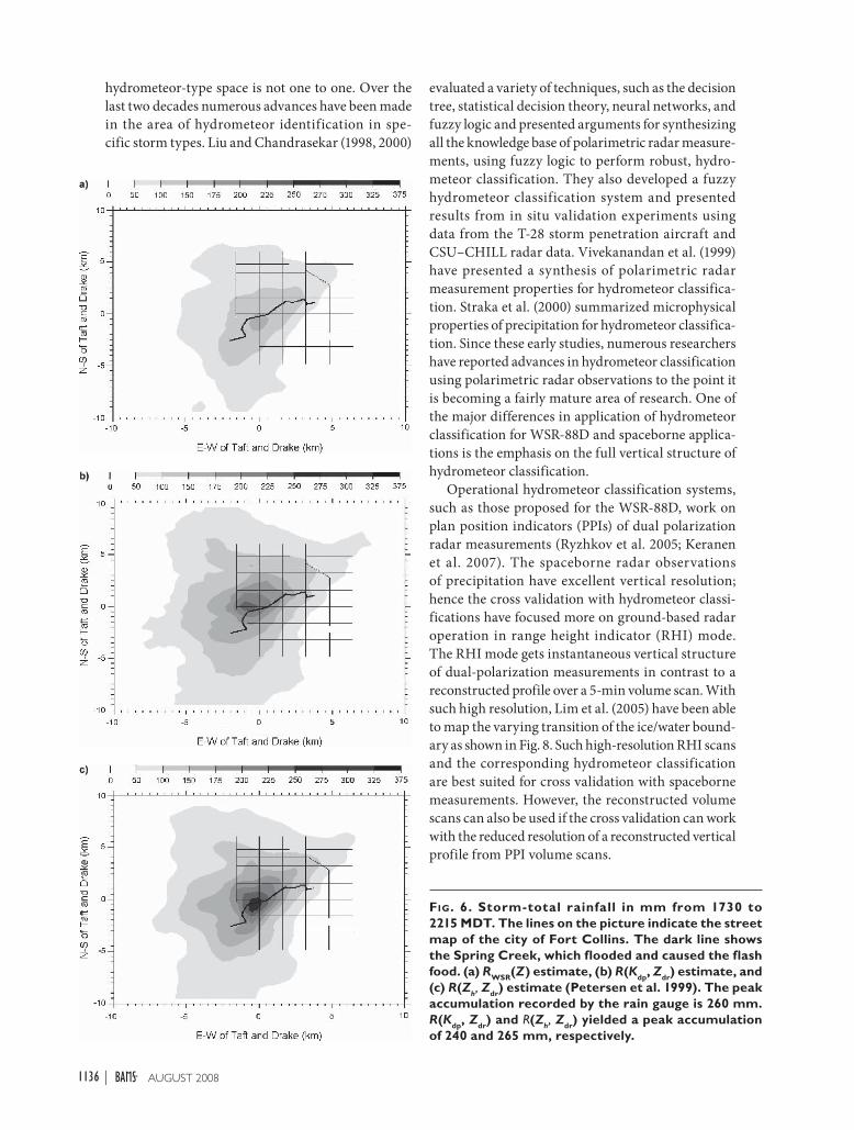
1997; Petersen et al. 1999). Figure 6 shows the rainfall
accumulation contours of R(Kdp
, Zdr
), R(Zh, Z
dr), and
NEXRAD Z–R to be compared against gage-based
contours for the Fort Collins flash flood event. The
corresponding rain gauge measurements yielded
a peak accumulation of 260 mm; R(Kdp
, Zdr
) and
R(Zh, Z
dr) yielded peak accumulation of 240 and
265 mm, respectively. It can be clearly seen from Fig. 6
that the polarimetric radar algorithms gave the best
estimate of rainfall.
A direct application of the polarimetric radar
algorithms will be difficult with ice contamination.
To account for this, hydrometeor classification and
rainfall estimation have been applied together as a
combined process to classify precipitation, before
quantification. This philosophy has led to the devel-
opment of blended algorithms (Petersen et al. 1999;
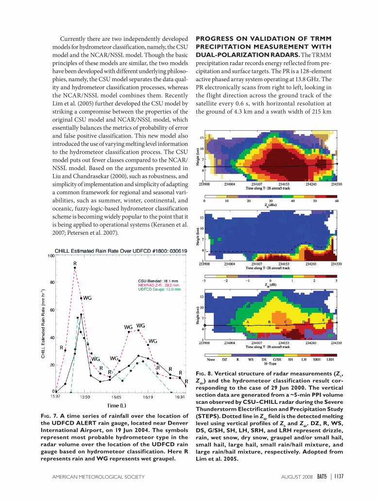
Cifelli et al. 2002). As an example, Fig. 7 shows a
time series of rainfall over the location of the Urban
Drainage and Flood Control District (UDFCD)
Automated Local Evaluation in Real Time (ALERT)
rain gauge, located near Denver International
Airport, on 19 June 2004. The time period shown
extends from 1547 local time (170.901 Julian day
UTC) to 1633 local time (170.942 Julian day UTC).
The green line shows the actual rain gauge trace and
the red and black lines represent rain-rate estimates
over the gauge using CHILL radar data in combina-
tion with the standard NEXRAD Z–R relationship
(red line) and blended polarimetric algorithm as
discussed above (black line). The latter method makes
use of Zdr
and Kdp
, in addition to Zh, to determine the
optimum rainfall estimator at each grid point in the
radar domain. The symbols represent the most prob-
able hydrometeor type in the radar volume over the
location of the UDFCD rain gauge, based on hydro-
meteor classification: “R” represents rain and “WG”
represents wet graupel. Note that the polarimetric
algorithm does a much better job at reproducing the
gauge estimate of rainfall, compared to the standard
ref lectivity-based technique. Because the blended
algorithm utilizes differential phase and differential
ref lectivity information in addition to Zh, it can
detect the likely presence of precipitation ice (e.g., wet
graupel) and adjust the rainfall retrieval algorithm to
produce more reliable estimates of rainfall.
Hydrometeor classif ication. Polarimetric radar mea-
surements are sensitive to the types, shapes, and size
distributions as well as fall behaviors of hydrometeors
in a radar resolution volume. As a result, extensive
information about the microphysics of hydromete-
ors is contained in the polarization diversity radar
measurements. The ability to classify hydrometeors
has a wide variety of applications, such as initializa-
tion and validation of cloud microphysical models,
choice of the right algorithm for precipitation
estimation, and evaluation of assumptions made in
the precipitation retrieval processes. The mapping
from polarimetric radar measurement space and
1135AUGUST 2008AMERICAN METEOROLOGICAL SOCIETY |
evaluated a variety of techniques, such as the decision
tree, statistical decision theory, neural networks, and
fuzzy logic and presented arguments for synthesizing
all the knowledge base of polarimetric radar measure-
ments, using fuzzy logic to perform robust, hydro-
meteor classification. They also developed a fuzzy
hydrometeor classification system and presented
results from in situ validation experiments using
data from the T-28 storm penetration aircraft and
CSU–CHILL radar data. Vivekanandan et al. (1999)
have presented a synthesis of polarimetric radar
measurement properties for hydrometeor classifica-
tion. Straka et al. (2000) summarized microphysical
properties of precipitation for hydrometeor classifica-
tion. Since these early studies, numerous researchers
have reported advances in hydrometeor classification
using polarimetric radar observations to the point it
is becoming a fairly mature area of research. One of
the major differences in application of hydrometeor
classification for WSR-88D and spaceborne applica-
tions is the emphasis on the full vertical structure of
hydrometeor classification.
Operational hydrometeor classification systems,
such as those proposed for the WSR-88D, work on
plan position indicators (PPIs) of dual polarization
radar measurements (Ryzhkov et al. 2005; Keranen
et al. 2007). The spaceborne radar observations
of precipitation have excellent vertical resolution;
hence the cross validation with hydrometeor classi-
fications have focused more on ground-based radar
operation in range height indicator (RHI) mode.
The RHI mode gets instantaneous vertical structure
of dual-polarization measurements in contrast to a
reconstructed profile over a 5-min volume scan. With
such high resolution, Lim et al. (2005) have been able
to map the varying transition of the ice/water bound-
ary as shown in Fig. 8. Such high-resolution RHI scans
and the corresponding hydrometeor classification
are best suited for cross validation with spaceborne
measurements. However, the reconstructed volume
scans can also be used if the cross validation can work
with the reduced resolution of a reconstructed vertical
profile from PPI volume scans.
FIG. 6. Storm-total rainfall in mm from 1730 to 2215 MDT. The lines on the picture indicate the street map of the city of Fort Collins. The dark line shows the Spring Creek, which flooded and caused the flash food. (a) RWSR(Z) estimate, (b) R(Kdp, Zdr) estimate, and (c) R(Zh, Zdr) estimate (Petersen et al. 1999). The peak accumulation recorded by the rain gauge is 260 mm. R(Kdp, Zdr) and R(Zh, Zdr) yielded a peak accumulation of 240 and 265 mm, respectively.
hydrometeor-type space is not one to one. Over the
last two decades numerous advances have been made
in the area of hydrometeor identification in spe-
cific storm types. Liu and Chandrasekar (1998, 2000)
1136 AUGUST 2008|
Currently there are two independently developed
models for hydrometeor classification, namely, the CSU
model and the NCAR/NSSL model. Though the basic
principles of these models are similar, the two models
have been developed with different underlying philoso-
phies, namely, the CSU model separates the data qual-
ity and hydrometeor classification processes, whereas
the NCAR/NSSL model combines them. Recently
Lim et al. (2005) further developed the CSU model by
striking a compromise between the properties of the
original CSU model and NCAR/NSSL model, which
essentially balances the metrics of probability of error
and false positive classification. This new model also
introduced the use of varying melting level information
to the hydrometeor classification process. The CSU
model puts out fewer classes compared to the NCAR/
NSSL model. Based on the arguments presented in
Liu and Chandrasekar (2000), such as robustness, and
simplicity of implementation and simplicity of adapting
a common framework for regional and seasonal vari-
abilities, such as summer, winter, continental, and
oceanic, fuzzy-logic-based hydrometeor classification
scheme is becoming widely popular to the point that it
is being applied to operational systems (Keranen et al.
2007; Petersen et al. 2007).
PROGRESS ON VALIDATION OF TRMM PRECIPITATION MEASUREMENT WITH DUAL-POLARIZATION RADARS. The TRMM
precipitation radar records energy reflected from pre-
cipitation and surface targets. The PR is a 128-element
active phased array system operating at 13.8 GHz. The
PR electronically scans from right to left, looking in
the f light direction across the ground track of the
satellite every 0.6 s, with horizontal resolution at
the ground of 4.3 km and a swath width of 215 km
FIG. 7. A time series of rainfall over the location of the UDFCD ALERT rain gauge, located near Denver International Airport, on 19 Jun 2004. The symbols represent most probable hydrometeor type in the radar volume over the location of the UDFCD rain gauge based on hydrometeor classification. Here R represents rain and WG represents wet graupel.
FIG. 8. Vertical structure of radar measurements (Zh, Zdr) and the hydrometeor classification result cor-responding to the case of 29 Jun 2000. The vertical section data are generated from a ~5-min PPI volume scan observed by CSU–CHILL radar during the Severe Thunderstorm Electrification and Precipitation Study (STEPS). Dotted line in Zdr field is the detected melting level using vertical profiles of Zh and Zdr. DZ, R, WS, DS, G/SH, SH, LH, SRH, and LRH represent drizzle, rain, wet snow, dry snow, graupel and/or small hail, small hail, large hail, small rain/hail mixture, and large rain/hail mixture, respectively. Adopted from Lim et al. 2005.
1137AUGUST 2008AMERICAN METEOROLOGICAL SOCIETY |

(Fig. 9). Each PR scan contains 49
rays sampled over an angular sector
of 34°. For any given ray, the instru-
ment begins recording samples at
a fixed distance from the satellite
and records a certain number of
samples along the ray. The starting
distance and the number of samples
are different for each ray. Rays other
than the nadir ray also sample below
the ground surface. The purpose of
this extension below the surface is
to clearly detect the location of the
surface.
The TRMM satellite has a circu-
lar nonsynchronous orbit with an
altitude of approximately 350 km.
This orbit allows the TRMM satel-
lite to pass over each part of the
surface of the Earth at a different
local time daily. The precipita-
tion radar parameters are listed in
Table 1. Iguchi et al. (2000) describe
the details of the algorithms used
by TRMM PR for attenu-
ation correction and rain-
fall estimation. Similarly
Kummerow et al. (2000)
describe the radiometer al-
gorithm for rainfall estima-
tion. The basic principle of
the TRMM PR algorithm
is described in Fig. 10. The
fundamental assumptions
of the TRMM PR retrieval
is the attenuation and rain-
fall rate are modeled as
power laws with reflectivity
governed by the propaga-
tion integral equation using
the surface reference as
boundary condition. The
path-integrated attenuation
estimate is subsequently
used to tune the coeffi-
cients of the power-law
relations used between re-
flectivity and attenuation.
The attenuation-corrected
reflectivity is used for rain-
fall estimate. The TRMM
PR algorithm (commonly
referred to as 2A25) also
TABLE 1. Precipitation radar parameters (adopted from TRMM Precipitation Radar Instruction Manual 2004).
Radar type Active phased array radar
Frequency 13.796 and 13.802 GHz (two-channel frequency agility)
Swath width About 215 km
Observable range Over 20 km
Range resolution 250 km
Horizontal resolution 4.3 km (nadir)
Sensitivity S/N per pulse ≥0 dB for 0.5 mm h–1 rain at rain top
Independent samples 64
Data rate 93.5 kbps
Weight 465 kg
Power 213 W
Antenna type 128-element slotted wave guide array antenna
Beam width 0.71° × 0.71°
Aperture 2.1 m × 2.1 m
Scan angle ±17°
Gain About 47.4 dB
Transmitter type Solid State Power Amplifier (SSPA) and Low Noise Amplifier (LNA) (128 channels)
Peak power Over 700 W
Pulse width 1.6 μsec × 2 ch
Pulse repetition frequency 2776 Hz
Dynamic range About 81.5 dB
FIG. 9. The observation concept of the PR (adopted from TRMM Precipitation Radar Instruction Manual 2004).
1138 AUGUST 2008|
adjusts for nonuniform
beam filling (NUBF). When
the rainfall rate is low the
surface reference is not re-
liable to compute the total
attenuation and a simple
iterative model is used for
attenuation correction and
rainfall estimation.
The TRMM program op-
erates many validation sites
around the globe. In addi-
tion, extensive field cam-
paigns were also conducted.
Among the validation sites,
the site in Darwin, Austra-
lia, has operated a C-band
dual-polarization Doppler
radar (C-POL) for an ex-
tended period. In addition,
the C-POL radar was de-
ployed during the SCSMEX.
Substantial contributions to rain microphysics and
rainfall algorithm development were contributed by
research and observations from this site. The impact of
raindrop oscillations and Kdp
-based rainfall algorithm
for tropics were demonstrated fairly early from this
site (Keenan et al. 1998). These concepts were further
developed into fundamental contributions to rainfall
microphysics. The C-POL data were also used to vali-
date the rain-profiling algorithm developed for ground
polarimetric radars. Among the other sites, the Texas
and Florida Underflights Experiment (TEFLUN-B)
and the TRMM Large-Scale Biosphere–Atmosphere
Experiment (TRMM LBA) both had full deployment
of the National Center for Atmospheric Research
S-POL radar, which is an S-band dual-polarization
Doppler radar (Carey et al. 2001; Cifelli et al. 2004;
Chandrasekar et al. 2003). Both deployments resulted
in development of methodologies for interpretation
of PR observations, evaluation of DSD assumptions,
precipitation regime classification, validation of PR
attenuation correction algorithms, and area rainfall
estimates. Nakagawa et al. (2004) presented similar
applications from the ground site in Okinawa.
In addition, a series of coordinated comparisons
have been made between TRMM PR observations
and ground polarimetric radar. Chandrasekar et al.
(2003) conducted careful pointwise comparisons
between TRMM PR and ground radar (GR) to show
the potential of ground polarimetric radars to assess
the attenuation correction process based on common
data framework between ground radars and TRMM
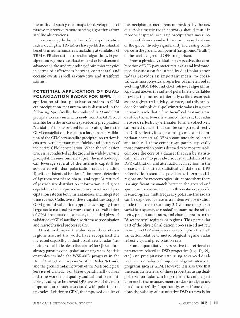
PR (Bolen and Chandrasekar 2003). Figure 11 shows
the schematic of comparing spaceborne and ground-
based radar observations. Figures 12a and 12b show a
vertical profile comparison of the various parameters
measured by the ground polarimetric radar, such as
reflectivity, differential reflectivity, LDR, and copolar
correlation, namely, compared against the TRMM
radar observations. Similar comparisons with C-band
polarimetric radars are shown in Fig. 12c. These com-
parisons were used to evaluate the accuracy of attenu-
ation correction done by the operational TRMM PR
algorithm. Direct intercomparison between TRMM
PR and ground-based radar is a challenging task.
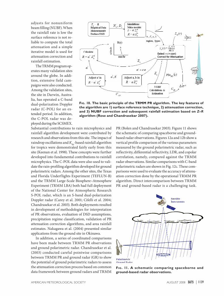
FIG. 10. The basic principle of the TRMM PR algorithm. The key features of the algorithm are 1) surface reference technique, 2) attenuation correction, and 3) NUBF correction and subsequent rainfall estimation based on Z–R algorithm (Rose and Chandrasekar 2007).
FIG. 11. A schematic comparing spaceborne and ground-based radar observations.
1139AUGUST 2008AMERICAN METEOROLOGICAL SOCIETY |

Difference in viewing aspects between Earth and
space observations, propagation paths, frequencies,
resolution volume size, and time synchronization
mismatch between space and ground-based obser-
vations can contribute to discrepancies in point-by-
point intercomparison (Bolen and Chandrasekar
2003). TRMM PR has been remarkably stable with
respect to calibration of the system as evidenced
by the active radar calibrator (Akihiro et al. 2004).
The Active Radar Calibrator (ARC)-based calibra-
tion system established the TRMM PR calibration
to an accuracy of within 1 dB. With the TRMM PR
being very stable and with advanced cross-validation
procedures, which account for frequency difference,
view angle, distortion, etc., the cross validation can be
really used for algorithm performance evaluation.
The normalized gamma DSD model was used by
Chandrasekar et al. (2003) to conduct microphysical
comparisons on a pixel basis from TRMM PR and
ground polarimetric radar. The Do retrieval algo-
rithm was presented in their paper. This concept
was extended to a global scale where global maps of
DSD estimates were constructed in Chandrasekar
et al. (2005). This global map is a further scale-up of
the DSD reported from different climatic region by
Bringi et al. (2003). Wilheit et al. (2007) have shown
FIG. 12. Example of ground-based observations and RSD estimates from data using TRMM LBA. (a) Vertical profile of GR reflectivity with location of PR beam indicated by solid vertical lines drawn to scale. (b) GR polarimetric observations along PR ray cor-responding to the ray as indicated in (a). From left to right, the dashed line is LDR, solid line with x’s is Kdp (scaled by a factor of 10), solid line with circles is Zdr (scaled by 10), black squares are PR measured (attenuated) reflectivity, white squares are PR attenu-ation corrected reflectivity, stars are GR measured reflectivity, and the dotted line is the cross-correlation coefficient between GR return signal horizontal and vertical polarization states, ρco (scaled by 100). In this plot, PR attenuation is observed to be about 7 dB with reference to GR measurements. In all panels, solid horizontal lines indicate the 0°C isocline altitude and the PR clutter level (certain), as derived from the TRMM data products, respectively. These types of pro-files were used to evaluate the accuracy of attenuation correction by the TRMM operational algorithm, while the accompanying dual-polarization measurements provide auxiliary information about the prevailing microphysics for interpretation of the cross valida-tion. (c) The (horizontally averaged) vertical profile of measured and corrected reflectivity from PR along with Zh, Zdr, and Kdp from the C-Pol GR. These data are for the Darwin ocean event of 3 Feb 2000. The Z match is quite good; it can be noted that average Zdr in the lower rain layer is around 0.8 dB, with Kdp reaching 1.5° km–1, indicating, on average, a maritime DSD with larger concentration of relatively smaller size. The scope of the comparison is similar to Fig. 12b.
1140 AUGUST 2008|
the utility of such global maps for development of
passive microwave remote sensing algorithms from
satellite observations.
In summary, the limited use of dual-polarization
radars during the TRMM era have yielded substantial
benefits in numerous areas, including a) validation of
TRMM PR attenuation correction algorithms, b) pre-
cipitation regime classification, and c) fundamental
advances in the understanding of rain microphysics
in terms of differences between continental and
oceanic events as well as convective and stratiform
storms.
POTENTIAL APPLICATION OF DUAL-POLARIZATION RADAR FOR GPM. The
application of dual-polarization radars to GPM
era precipitation measurements is discussed in the
following. Specifically, the combined DPR and GMI
precipitation measurements made from the GPM core
satellite form the nexus of a spaceborne precipitation
“validation” tool to be used for calibrating the entire
GPM constellation. Hence to a large extent, valida-
tion of the GPM core satellite precipitation retrievals
ensures overall measurement fidelity and accuracy of
the entire GPM constellation. When the validation
process is conducted at the ground in widely varying
precipitation environment types, the methodology
can leverage several of the intrinsic capabilities
associated with dual-polarization radar, including
1) self-consistent calibration; 2) improved detection
of hydrometeor phase, shape, and type; 3) retrieval
of particle size distribution information; and 4) via
capabilities 1–3, improved accuracy in retrieved pre-
cipitation rate (on both instantaneous and integrated
time scales). Collectively, these capabilities support
GPM ground validation approaches ranging from
large-scale national network statistical validation
of GPM precipitation estimates, to detailed physical
validation of GPM satellite algorithms at precipitation
and microphysical process scales.
At national network scales, several countries/
regions around the world have recognized the
increased capability of dual-polarimetric radar (i.e.,
the four capabilities described above) for QPE and are
already pursuing dual-polarization upgrades. Specific
examples include the WSR-88D program in the
United States, the European Weather Radar Network,
and the ground radar network of the Meteorological
Service of Canada. For these operationally driven
radar networks data quality and calibration moni-
toring leading to improved QPE are two of the most
important attributes associated with polarimetric
upgrades. Relative to GPM, the improved quality of
the precipitation measurement provided by the new
dual-polarimetric radar networks should result in
more widespread, accurate precipitation measure-
ments with lower standard error over many locations
of the globe, thereby significantly increasing confi-
dence in the ground component (i.e., ground “truth”)
of the satellite–ground QPE comparison.
From a physical validation perspective, the com-
bination of DSD parameter retrievals and hydrome-
teor classification facilitated by dual-polarization
radars provides an important means to cross-
validate microphysical properties parameterized in
evolving GPM DPR and GMI retrieval algorithms.
As stated above, the suite of polarimetric variables
provides the means to internally calibrate/correct/
assure a given reflectivity estimate, and this can be
done for multiple dual-polarimetric radars in a given
network, such that a “uniform” calibration stan-
dard for the network is attained. In turn, the radar
network ref lectivity estimates form a collectively
calibrated dataset that can be compared directly
to DPR ref lectivities (assuming consistent com-
parison geometries). When continuously collected
and archived, these comparison points, especially
those comparison points deemed to be most reliable,
compose the core of a dataset that can be statisti-
cally analyzed to provide a robust validation of the
DPR calibration and attenuation correction. In the
process of this direct statistical validation of DPR
reflectivities it should be possible to discern specific
regions and/or meteorological situations where there
is a significant mismatch between the ground and
spaceborne measurements. In this instance, specific
research-grade multifrequency polarimetric radars
can be deployed for use in an intensive observation
mode (i.e., free to scan any 3D volume of space at
variable frequency as needed) to examine the reflec-
tivity, precipitation rates, and characteristics in the
“discrepancy” regimes or regions. This particular
part of the physical validation process need not rely
heavily on DPR overpasses to accomplish the DSD
validation relative to meteorological regime, radar
reflectivity, and precipitation rate.
From a quantitative perspective the retrieval of
parameters related to DSD properties (e.g., Do, N
w,
etc.) and precipitation rate using advanced dual-
polarimetric radar techniques is of great interest to
programs such as GPM. However, it is also true that
the accurate retrieval of these properties using dual-
polarization radar can be problematic and subject
to error if the measurements and/or analyses are
not done carefully. Importantly, even if one ques-
tions the validity of quantitative DSD retrievals for
1141AUGUST 2008AMERICAN METEOROLOGICAL SOCIETY |
a given radar, there remain qualitative aspects of the
dual-polarimetric measurements that lend them-
selves readily to precipitation retrieval algorithm
validation. For example, at the most basic qualitative
level the fundamental ability of dual-polarization
radar to distinguish between liquid, ice, and mixed
water phases in the vertical structure of precipita-
tion is likely to play a crucial role in the develop-
ment of both dual-frequency radar algorithms as
well as combined radar–radiometer algorithms. The
delineation between the water phases is currently an
outstanding problem in the retrieval of precipita-
tion rates from passive microwave sensors. To this
end, cloud-resolving models capable of generating
realistic synthetic hydrometeor profiles, including
the mixed phase, are important to the process of
algorithm development and testing. As part of this
process dual-polarization radar-diagnosed profiles of
hydrometeors and hydrometeor phases can be linked
to radar-derived precipitation rates and then used to
verify the general characteristics of simulated cloud
model microphysics used in the algorithm develop-
ment process.
In summary, the ability of the dual-polarization
radar to supply both basic qualitative information
related to hydrometeor phase/type information (in
three dimensions) coupled with the potential for more
advanced quantitative retrieval of DSD properties is
of great interest to GPM. It is also important to note
that because the aforementioned data are typically
collected by polarimetric radars possessing scan-
ning agility, variable area coverage, and temporal
continuity of operation (especially true of research
radars), the data represent more than just “snapshot”
retrievals of the precipitation. Samples of the pre-
cipitation characteristics and rates can be retrieved
over the entire life cycle of given precipitation events
and over large areas, making dual-polarimetric
radar a valuable analytic instrument for future GPM
applications.
ACKNOWLEDGMENTS. The authors acknowledge
support from NASA, the National Science Foundation,
and the Italian Space Agency via grants over the years
that have contributed to the research results presented in
this article.
REFERENCESAkihiro, M., T. Nobuhiro, K. Hiroshi, and T. Toyoyuki,
2004: Calibration of the TRMM Precipitation Radar
using the active radar calibrator (ARC). J. Remote
Sens. Soc. Japan, 24, 367–377.
Andsager, K., K. V. Beard, and N. F. Laird, 1999: Labora-
tory measurements of axis ratios for large raindrops.
J. Atmos. Sci., 56, 2673–2683.
Aydin, K., H. Direskeneli, and T. A. Seliga, 1987: Dual-
polarization radar estimation of rainfall parameters
compared with ground-based disdrometer measure-
ments: October 29, 1982, Central Illinois experiment.
IEEE Trans. Geosci. Remote Sens., GE-25, 834–844.
—, V. N. Bringi, and L. Liu, 1995: Rain-rate estimation
in the presence of hail using S-band specific dif-
ferential phase and other radar parameters. J. Appl.
Meteor., 34, 404–410.
Beard, K. V., and C. Chuang, 1987: A new model for
the equilibrium shape of raindrops. J. Atmos. Sci.,
44, 1509–1524.
Bolen, S. M., and V. Chandrasekar, 2003: Methodology
for aligning and comparing spaceborne radar and
ground-based radar observations. J. Atmos. Oceanic
Technol., 20, 647–659.
Brandes, E. A., J. Vivekanandan, and J. W. Wilson, 1997:
Radar rainfall estimates of the Buffalo Creek flash
flood using WSR-88D and polarimetric radar data.
Preprints, 28th Conf. on Radar Meteorology, Austin,
TX, Amer. Meteor. Soc., 123–124.
Bringi, V. N., and V. Chandrasekar, 2001: Polarimetric
Doppler Weather Radar: Principles and Applications.
Cambridge University Press, 636 pp.
—, —, and R. Xiao, 1998: Raindrop axis ratios and
size distributions in Florida rainshafts: An assess-
ment of multiparameter radar algorithms. IEEE
Trans. Geosci. Remote Sens., 36, 703–715.
—, G.-J. Huang, V. Chandrasekar, and T. D. Keenan,
2001: An areal rainfall estimator using differential
propagation phase: Evaluation using a C-band radar
and a dense gauge network in the tropics. J. Atmos.
Oceanic Technol., 18, 1810–1818.
—, V. Chandrasekar, J. Hubbert, E. Gorgucci, W. L.
Randeu, and M. Schoenhuber, 2003: Raindrop size
distribution in different climatic regimes from dis-
drometer and dual-polarized radar analysis. J. Atmos.
Sci., 60, 354–365.
—, T. Tang, and V. Chandrasekar, 2004: Evaluation of
a new polarimetrically based Z–R relation. J. Atmos.
Oceanic Technol., 21, 612–623.
Carey, L. D., R. Cifelli, W. A. Petersen, S. A. Rutledge,
and M. A. F. Silva Dias, 2001: Characteristics of
Amazonian rain measured during TRMM-LBA.
Preprints, 30th Int. Conf. on Radar Meteorology,
Munich, Germany, Amer. Meteor. Soc., 682–684.
Chandrasekar, V., and V. N. Bringi, 1988: Error structure
of multiparameter radar and surface measurements
of rainfall. Part I: Differential reflectivity. J. Atmos.
Oceanic Technol., 5, 783–795.
1142 AUGUST 2008|

—, W. A. Cooper, and V. N. Bringi, 1988: Axis ratios
and oscillations of raindrops. J. Atmos. Sci., 45,
1323–1333.
—, V. N. Bringi, N. Balakrishnan, and D. S. Zrnic,
1990: Error structure of multiparameter radar and
surface measurements of rainfall. Part III: Specific
differential phase. J. Atmos. Oceanic Technol., 7,
621–629.
—, S. M. Bolen, and E. Gorgucci, 2003: Microphysi-
cal cross validation of spaceborne radar and ground
polarimetric radar. IEEE Trans. Geosci. Remote Sens.,
41, 2153–2165.
—, W. Li, and B. Zafar, 2005: Estimation of rain-
drop size distribution from spaceborne radar
observations. IEEE Trans. Geosci. Remote Sens.,
43, 1078–1086.
Chang, A. T. C., L. S. Chiu, C. Kummerow, J. Meng,
and T. T. Wilheit, 1999: First results of the TRMM
microwave imager (TMI) monthly oceanic rain
rate: Comparison with SSM/I. Geophys. Res. Lett.,
26, 2379–2382.
Cifelli, R., W. A. Petersen, L. D. Carey, and S. A.
Rutledge, 2002: Radar Observations of the Kinemat-
ic, Microphysical, and Precipitation Characteristics
of Two MCSs in TRMM-LBA. J. Geophys. Res, 107,
doi:10.1029/2000JD0000264.
—, L. C. Carey, W. A. Petersen, and S. A. Rutledge,
2004: An ensemble study of wet season convection in
Southwest Amazon: Kinematics and implications for
diabatic heating. J. Climate, 17, 4692–4707.
Doviak, R. J., V. Bringi, A. Ryzhkov, A. Zahrai, and
D. Zrnic, 2000: Considerations for polarimetric
upgrades to operational WSR-88D radars. J. Atmos.
Oceanic Technol., 17, 257–278.
Goddard, J. W. F., and S. M. Cherry, 1984: The ability
of dual-polarization radar (copolar linear) to predict
rainfall rate and microwave attenuation. Radio Sci.,
19, 201–208.
Gorgucci, E., G. Scarchilli, and V. Chandrasekar, 1992:
Calibration of radars using polarimetric techniques.
IEEE Trans. Geosci. Remote Sens., 30, 853–858.
—, —, and —, 2000: Measurement of mean rain-
drop shape from polarimetric radar observations. J.
Atmos. Sci., 57, 3406–3413.
—, —, —, and V. N. Bringi, 2001: Rainfall
estimation from polarimetric radar measurements:
Composite algorithms immune to variability in rain-
drop shape-size relation. J. Atmos. Oceanic Technol.,
18, 1773–1786.
—, V. Chandrasekar, V. N. Bringi, and G. Scarchilli,
2002: Estimation of raindrop size distribution
parameters from polarimetric radar measurements.
J. Atmos. Sci., 59, 2373–2384.
Hubbert, J., and F. Pratte, 2007: Differential reflectiv-
ity calibration for NEXRAD. Proc. IGARSS 2006,
Denver, CO, IGARSS, 519–522.
Iguchi, T., T. Kozu, R. Meneghini, and K. Okamoto,
2000: A new hybrid surface reference method for
the TRMM Precipitation Radar. Proc. IGARSS 2000,
Honolulu, HI, IGARSS, 1346–1348.
Jameson, A. R., 1985: Microphysical interpretation of
multi-parameter radar measurements in rain. Part
III: Interpretation and measurement of propagation
differential phase shift between orthogonal linear
polarizations. J. Atmos. Sci., 42, 607–614.
Joe, P., and P. L. Smith, 2001: Summary of the radar
calibration workshop. Preprints, 30th Radar Meteo-
rology Conf., Munich, Germany, Amer. Meteor. Soc.,
3.1. [Available online at http://ams.confex.com/ams/
pdfpapers/21882.pdf.]
Keenan, T., K. Glasson, F. Cummings, T. S. Bird,
J. Keeler, and J. Lutz, 1998: The BMRC/NCAR
C-Band Polarimetric (C-POL) radar system. J. Atmos.
Oceanic Technol., 15, 871–886.
Keranen, R., E. Saltikoff, V. Chandrasekar, S. Lim, J.
Holmes, and J. Selzler, 2007: Real-time hydrome-
teor classification for the operational forecasting
environment. Preprints, 33rd Radar Meteorology
Conf., Cairns, Australia, Amer. Meteor. Soc., P11B.11.
[Available online at http://ams.confex.com/ams/
pdfpapers/123476.pdf.]
Kubesh, R. J., and K. V. Beard, 1993: Laboratory mea-
surements of spontaneous oscillations for moderate-
size raindrops. J. Atmos. Sci., 50, 1089–1098.
Kummerow, C., and Coauthors, 2000: The status of the
tropical rainfall measuring mission (TRMM) after
two years in orbit. J. Appl. Meteor., 39, 1965–1982.
L’Ecuyer, T. S., C. Kummerow, and W. Berg, 2004:
Toward a global map of raindrop size distribu-
tions. Part I: Rain-type classification and its im-
plications for validating global rainfall products. J.
Hydrometeor., 5, 831–849.
Lim, S., V. Chandrasekar, and V. N. Bringi, 2005: Hydro-
meteor classification system using dual-polarization
radar measurements: Model improvements and in
situ verification. IEEE Trans. Geosci. Remote Sens.,
43, 792–801.
Liu, H., and V. Chandrasekar, 1998: An adaptive neural
network scheme for precipitation estimation from
radar observations. Proc. IGARSS 1998, Seattle, WA,
IGARSS, 1895–1897.
—, and —, 2000: Classification of hydromete-
ors based on polarimetric radar measurements:
Development of fuzzy logic and neuro-fuzzy systems,
and in situ verification. J. Atmos. Oceanic Technol.,
17, 140–164.
1143AUGUST 2008AMERICAN METEOROLOGICAL SOCIETY |
McCormick, G. C., and A. Hendry, 1975: Principles for
the radar determination of the polarization proper-
ties of precipitation. Radio Sci., 10, 421–434.
Moisseev, D. N., and V. Chandrasekar, 2007: Nonpara-
metric estimation of raindrop size distributions
from dual-polarization radar spectral observations.
J. Atmos. Ocean. Technol., 24, 847–855.
Nakagawa, K., H. Hanado, S. Sato, and T. Iguchi,
2003: Development of the CRL Okinawa Bistatic
Polarimetric Radar. J. Commun. Res. Lab., 49,
225–231.
—, —, N. Takahashi, S. Satoh, T. Iguchi, and
K. Fukutani, 2004: Polarimetric rainfall observa-
tions with COBRA in the rainy season. Proc. Sixth
Int. Sympo. on Hydrological Applications of Weather
Radar, Melbourne, Australia, Australian Bureau of
Meteorology.
National Research Council, 2006: Assessment of the
Benefits of Extending the Tropical Rainfall Measuring
Mission. National Academies Press, 103 pp.
—, 2007: NOAA’s Role in Space-Based Global Precipita-
tion Estimation and Application. National Academies
Press, 142 pp.
Parent, J., P. Tabary, and M. Guimera, 2005: The
Panthere project and the evolution of the French
operational radar network and products: Rain-
estimation, Doppler winds and dual-polarisation.
Preprints, 32nd Conf. on Radar Meteorology,
Albuquerque, NM, Amer. Meteor. Soc., 14R.6.
[Available online at http://ams.confex.com/ams/
pdfpapers/96217.pdf.]
Petersen, W. A., and Coauthors, 1999: Mesoscale and
radar observations of the Fort Collins flash flood of
28 July 1997. Bull. Amer. Meteor. Soc., 80, 191–216.
—, K. R. Knupp, D. J. Cecil, and J. R. Mecikalsi,
2007: The University of Alabama Huntsville THOR
Center instrumentation: Research and operational
collaboration. Preprints, 33rd Int. Conf. on Radar
Meteorology, Cairns, Australia, Amer. Meteor.
Soc.,5.1. [Available online at http://ams.confex.com/
ams/pdfpapers/123410.pdf.]
Pruppacher, H. R., and K. V. Beard, 1970: A wind tunnel
investigation of the internal circulation and shape of
water drops falling at terminal velocity in air. Quart.
J. Roy. Meteor. Soc., 96, 247–256.
Raghavan, R., and V. Chandrasekar, 1994: Multiparam-
eter radar study of rainfall: Potential application
to area–time integral studies. J. Appl. Meteor., 33,
1636–1645.
Rose, C. R., and V. Chandrasekar, 2007: Systems
Engineering Analysis of a TRMM PR-Like Rainfall
Retrieval Algorithm. IEEE Trans. Geosci. Remote
Sens., 45 (2), 426–434.
Rosenfeld, D., and C. W. Ulbrich, 2003: Cloud micro-
physical properties, processes, and rainfall estima-
tion opportunities. Radar and Atmospheric Science:
A Collection of Essays in Honor of David Atlas, R. M.
Wakimoto and R. Srivastava, Eds., Amer. Meteor.
Soc., 237–258.
Ryzhkov, A., D. Zrnic, and R. Fulton, 2000: Areal
rainfall estimates using differential phase. J. Appl.
Meteor., 39, 263–268.
—, T. J. Schuur, D. W. Burgess, P. L. Heinselman, S. E.
Giangrande, and D. S. Zrnic, 2005: The Joint Polar-
ization Experiment: Polarimetric rainfall measure-
ments and hydrometeor classification. Bull. Amer.
Meteor. Soc., 86, 809–824.
Sachidananda, M., and D. S. Zrnic, 1987: Rain rate esti-
mates from differential polarization measurements.
J. Atmos. Oceanic Technol., 4, 588–598.
Scarchilli, G., E. Gorgucci, V. Chandrasekar, and
A. Dobaie, 1996: Self-consistency of polarization
diversity measurement of rainfall. IEEE Trans.
Geosci. Remote Sens., 34, 22–26.
Schroth, A., M. Chandra, and P. Meischner, 1988:
C-band coherent polarimetric radar for propaga-
tion and cloud physics research. J. Atmos. Oceanic
Technol., 5, 803–822.
Schuur, T. J., A. V. Ryzhkov, D. S. Zrnic, and M.
Schoenhuber, 2001: Drop size distributions measured
by a 2D video disdrometer: Comparison with dual-
polarization data. J. Appl. Meteor., 40, 1019–1034.
Seliga, T. A., and V. N. Bringi, 1976: Potential use of
the radar ref lectivity at orthogonal polarizations
for measuring precipitation. J. Appl. Meteor., 15,
69–76.
—, and —, 1978: Differential reflectivity and differ-
ential phase shift: Applications in radar meteorology.
Radio Sci., 13, 271–275.
—, —, and H. H. Al-Khatib, 1981: A preliminary
study of comparative measurement of rainfall rate
using the differential ref lectivity radar technique
and a raingauge network. J. Appl. Meteor., 20,
1362–1368.
Shimizu, S., R. Oki, M. Kachi, M. Kojima, T. Iguchi, and
K. Nakamura, 2006: Development and validation of
spaceborne dual-frequency precipitation radar for
GPM. Proc. IGARSS 2006, Denver, CO, IGARSS,
29–31.
Straka, J. M., D. S. Zrnic, and A. V. Ryzhkov, 2000: Bulk
hydrometeor classification and quantification using
polarimetric radar data: Synthesis of relations. J.
Appl. Meteor., 39, 1341–1372.
Thurai, M., and V. N. Bringi, 2005: Drop axis ratios from
a 2D video disdrometer. J. Atmos. Oceanic Technol.,
22, 966–978.
1144 AUGUST 2008|
TRMM Precipitation Radar Instruction Manual, cited
2004: Tropical Rainfall Measuring Mission (TRMM)
precipitation radar algorithm instruction manual,
version 2.0. [Available online at www.eorc.nasda.go.jp/
TRMM/document/pr_manual/pr_manual2.pdf.]
Vivekanandan, J., S. M. Ellis, R. Oye, D. S. Zrnic, A. V.
Ryzhkov, and J. Straka, 1999: Cloud microphysics
retrieval using S-band dual-polarization radar mea-
surements. Bull. Amer. Meteor. Soc., 80, 381–388.
Waldvogel, A., W. Henrich, and W. Schmid, 1995:
Raindrop size distributions and radar reflectivity
profiles. Preprints, Conf. on Radar Meteorology, Vail,
CO, Amer. Meteor. Soc., 26–28.
Wang, Y., and V. Chandrasekar, 2006: Polarization
isolation requirements for linear dual-polarization
weather radar in simultaneous transmission mode
of operation. IEEE Trans. Geosci. Remote Sens., 44,
2019–2028.
Wilheit, T., V. Chandrasekar, and W. Li., 2007: Impact
of uncertainty in the drop size disatribution on
oceanic retrievals from passive microwave ob-
servations. IEEE Trans. Geosci. Remote Sens., 45,
3160–3164.
Zafar, B. J., and V. Chandrasekar, 2004: SOM of space
borne precipitation radar rain profiles on global
scale. Proc. IGARSS 2004, Anchorage, IGARSS,
925–928.
Zrnic, D. S., and A. Ryzhkov, 1996: Advantages of rain
measurements using specific differential phase. J.
Atmos. Oceanic Technol., 13, 454–464.
1145AUGUST 2008AMERICAN METEOROLOGICAL SOCIETY |